

Data Gap Analysis for Estimation of Agricultural Return Flows in the Upper Gunnison River Basin, Colorado
Links
- Document: Report (2.86 MB pdf) , HTML , XML
- Database: USGS data base USGS water data for the Nation: U.S. Geological Survey National Water Information System database
- NGMDB Index Page: National Geologic Map Database Index Page (html)
- Download citation as: RIS | Dublin Core
Abstract
The Gunnison River and many tributaries in the Upper Gunnison River Basin provide water to irrigate agricultural crops. The application of irrigation water can recharge some aquifers locally by water percolating below the root zone and eventually flowing back to the stream or river through the subsurface. Diverting surface water for irrigation reduces streamflow during the irrigation season but can provide temporary storage of water and supplement streamflow after the snowmelt runoff season. Understanding the timing and quantity of agricultural return flows could help resource managers make informed decisions and adapt to potential changes in water management and availability that could affect irrigation practices. In 2024, the U.S. Geological Survey, in cooperation with the Upper Gunnison River Water Conservancy District, began a study to characterize agricultural return flows in the Upper Gunnison River Basin by using endmember mixing analysis and developing a groundwater model. Both approaches require data from multiple sources, but data gaps exist in the East River study reach and other reaches of interest (Ohio Creek, Tomichi Creek, and Cochetopa Creek). The East River Basin, which is the initial focus of the study, has fewer data gaps than the other basins. Data gaps could be addressed by installing additional surface water and groundwater monitoring sites, making regular streamflow measurements on tributaries, and completing tests to characterize local aquifer properties.
Introduction
The Colorado River provides water for millions of people and agricultural uses in several States; however, imbalances among supply and consumption, climate change, and drought have led to water shortages and low storage in major reservoirs (Bureau of Reclamation, 2012; Schmidt and others, 2023). Because the 2007 Interim Guidelines for Lower Basin Shortages and Coordinated Operations for Lake Powell and Lake Mead are set to expire on December 31, 2026, there is the potential for changes in the management of water in the Colorado River Basin (Fleck and Castle, 2022; Bureau of Reclamation, 2023).
The Gunnison River is a major tributary in the Colorado River headwaters. Agriculture is the greatest consumptive use of water in the Gunnison River Basin, where canals and ditches divert water from streams to more than 250,000 irrigated acres (Gunnison Basin Roundtable, 2022). In some areas, the application of irrigation water can recharge aquifers locally by water percolating below the root zone and eventually flowing back to the stream or river through the subsurface. Diverting surface water for irrigation reduces streamflow during the irrigation season but can provide temporary storage of water and supplement streamflow after the spring snowmelt runoff season when flows are high (Fernald and others, 2010; Gordon and others, 2020; Ferencz and Tidwell, 2022; Ketchum and others, 2023). Understanding the timing and quantity of agricultural return flows in the Gunnison River Basin could help resource managers make informed decisions and adapt to potential future changes in water management and availability that could affect irrigation practices.
In 2024, the U.S. Geological Survey (USGS) began a study in cooperation with the Upper Gunnison River Water Conservancy District to characterize surface water and groundwater interactions, specifically agricultural return flows along an East River study reach, in the Upper Gunnison River Basin, Colorado. The study objectives are to complete an endmember mixing analysis (Christophersen and Hooper, 1992) to estimate the timing and amounts of agricultural return flow and to create a groundwater model to simulate recharge, discharge to surface water, and surface-water and groundwater interactions (Bakker and others, 2016; Leaf and Fienen, 2022). Although the East River is the focus of this study, work could be expanded to other basins in the future, and reaches of interest have been identified on Ohio Creek, Tomichi Creek, and Cochetopa Creek (fig. 1). The East River study reach was selected within an area of irrigated land with existing USGS streamgages to represent the upstream and downstream ends of the reach and minimal tributary inflow. Data are collected for the study by monitoring flows within the study reach, irrigation ditches, and tributaries; monitoring groundwater levels; and analyzing the chemical composition of surface water and groundwater.
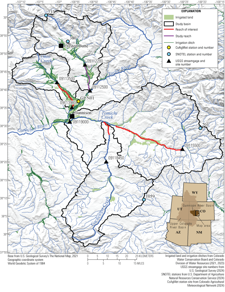
Map showing locations of East River study reach and Ohio Creek, Tomichi Creek, and Cochetopa Creek reaches of interest, U.S. Geological Survey (USGS) streamgage sites, and irrigation ditches in irrigated land in the Upper Gunnison River Basin, Colorado. CoAgMet, Colorado Agricultural Meteorological Network; SNOTEL, Snow Telemetry Network.
Purpose and Scope
The purpose of this report is to describe the available information and data gaps for modeling groundwater and surface water interactions, specifically the estimation of agricultural return flows, in the East River, Ohio Creek, Tomichi Creek, and Cochetopa Creek, within the Upper Gunnison River Basin (fig. 1). Although the East River is the focus of this study, Ohio Creek, Tomichi Creek, and Cochetopa Creek also provide water for irrigation and could be used as study areas for estimating agricultural return flows. The data gap analysis in this report uses existing datasets and results from previously published studies. Datasets and reports available for the study basins were identified and reviewed for their utility in estimating agricultural return flows. The absence of information or datasets of beneficial use was designated as a data gap. The information provided in this report could be useful for supporting selection of additional sites and study planning.
Study Area Description
The East River, Ohio Creek, Tomichi Creek, and Cochetopa Creek (table 1) are mountainous headwater streams within the Upper Gunnison River Basin, which drains about 10,350 square kilometers of the Upper Colorado River Basin in southwestern Colorado (U.S. Geological Survey, 2019). Land cover in the Upper Gunnison River Basin is primarily characterized by evergreen forest (38.5 percent), shrub and scrubs (32.6 percent), and deciduous forest (12.0 percent; Dewitz and U.S. Geological Survey, 2021). Snowmelt is the dominant source of water, with monsoon storms also contributing high-intensity but short-lasting precipitation in the summer months (Carroll and others, 2020a). The climate in the Upper Gunnison River Basin is continental subarctic (Peel and others, 2007), with long winters followed by brief, temperate summers that support the growth of hay and other pasture grasses (Dewitz and U.S. Geological Survey, 2021). The East River, Ohio Creek, Tomichi Creek, and Cochetopa Creek provide water for irrigation (Upper Gunnison River Water Conservancy District, 2019). Canals and ditches divert water from streams (fig. 1) to pastures where it is applied using flood irrigation practices. The irrigation season is generally from May through October (Upper Gunnison River Water Conservancy District, 2019).
Table 1.
Study basins within the Upper Gunnison River Basin, Colorado.[Data from U.S. Geological Survey, 2019. NAVD 88, North American Vertical Datum of 1988]
Previous Studies
Regional models have been completed or are planned for areas that include the study basins of the East River, Ohio Creek, Tomichi Creek, and Cochetopa Creek (Colorado Water Conservation Board and Colorado Division of Water Resources, 2016; U.S. Geological Survey, 2018). The State of Colorado has developed StateMod, a surface-water model that represents streamflow, diversions, reservoir operations, and other water management policies to simulate changes in water management (Colorado Water Conservation Board and Colorado Division of Water Resources, 2016). A version of StateMod has been calibrated as a water-resources planning model for the Gunnison River Basin from 1975 through 2013 and includes basin-specific data on water rights and diversions from streams. Diversions with water rights fewer than 9 cubic feet per second were aggregated within subbasins (except for the Tomichi Creek Basin, which was considered a basin of interest and modeled in more detail than other areas). The Gunnison River Basin StateMod includes scenarios for irrigation return flow from fields close to (about 183 meters [m]) and far from (about 457 m) a stream using generalized aquifer properties averaged from 10 sites throughout the basin. The model estimates the timing of return flow (on the surface and in the subsurface) by assuming that 78.6 percent of return flow from close fields and 60.4 percent of return flow from far fields enters the stream during the same month the water was diverted (Colorado Water Conservation Board and Colorado Division of Water Resources, 2016). Smaller amounts of return flow enter the stream in later months (Colorado Water Conservation Board and Colorado Division of Water Resources, 2016). StateMod files and datasets are available for download (Colorado Water Conservation Board and Colorado Division of Water Resources, 2024b) and can be used for developing new models for study reaches. The USGS plans to develop a regional model for groundwater and surface-water interactions in the Upper Colorado River Basin, which includes the Gunnison River Basin (U.S. Geological Survey, 2018; Sweetkind and others, 2023; Lopez and others, 2024).
The East River Basin was designated as a Watershed Function Scientific Focus Area by the U.S. Department of Energy in 2015 to study hydrological-biogeochemical dynamics (Kakalia and others, 2021). Researchers from many organizations have contributed to data collection in the East River Basin as a community testbed (Hubbard and others, 2018; Kakalia and others, 2021). Data from sensors, cameras, surveys, continuous monitoring, and discrete samples support research on multiple topics, including snowmelt, drought, nutrients, and surface-water and groundwater interactions (Varadharajan and others, 2019; Kakalia and others, 2021). Although a large amount of information is available (Kakalia and others, 2021), the East River community testbed efforts have generally focused on the part of the basin north of Crested Butte, Colo., whereas the East River study reach and other reaches of interest for this USGS study are south of Crested Butte (fig. 1).
Data collected as part of the Watershed Function Scientific Focus Area were used in the development of an integrated hydrologic model of the East River Basin (Carroll and others, 2023, 202410) using the USGS groundwater and surface water flow model (GSFLOW) (Markstrom and others, 2008), which integrates the MODFLOW model (Harbaugh, 2005; Niswonger and others, 2011) and the Precipitation-Runoff Modeling System, a physical-process hydrologic model (Markstrom and others, 2015). The GSFLOW model was calibrated with data from 1986 to 2022 and tracks water from the atmosphere through the subsurface at a resolution of 100 m and with daily time steps. It includes a three-dimensional groundwater flow component that extends 400 m below the ground surface (Carroll and others, 2023, 2024). The GSFLOW model and other studies from the Watershed Function Scientific Focus Area (Carroll and others, 2018, 2019, 2020b, 2024) have been used to evaluate the occurrence, distribution, and characteristics of groundwater within the headwaters of the East River Basin. Topography, snowpack, and vegetation structure have important effects on groundwater recharge in the basin (Carroll and others, 2018). Endmember mixing analysis using stable isotopes of calcium, strontium, uranium, and sulfate as tracers showed that groundwater is the source of roughly one-third of the streamflow leaving the Upper East River Basin annually, with the remainder of the stream water sourced from shallow, subsurface flow (interflow) and surface runoff (Carroll and others, 2018). During a drought, interflow and runoff contributions to streamflow decrease, and the supply from groundwater becomes more critical to maintaining in-channel flows (Carroll and others, 2019). However, these dry-year groundwater contributions are drawn from old, deep aquifers that recharge slowly, especially after extremely dry conditions (Carroll and others, 2020b, 2024). The effects of irrigation on groundwater storage and recharge were not included in the GSFLOW modeling done for the headwaters of the East River (Carroll and others, 2024). The GSFLOW model files are available for download (Carroll and others, 2023) and could be used to help develop a model for the East River study reach. Markstrom and others (2012) also used the Precipitation Runoff Modeling System to simulate hydrology in the East River Basin and examined the response to potential future climate projections. The models indicate that groundwater recharge, storage, and streamflow in the East River Basin could decline during warming conditions (Markstrom and others, 2012; Carroll and others, 2024).
Data Availability and Data Gaps
The overall objectives of the study are to characterize agricultural return flows in the East River Basin by using endmember mixing analysis and developing a groundwater model. Streamflow data and other data on water entering and leaving the system are necessary for both types of analysis. The groundwater model could be built using MODFLOW and related packages (Bakker and others, 2016; Leaf and Fienen, 2022), which need data from multiple sources, including information on water chemistry, streamflow, surface-water use, aquifer characteristics, groundwater levels, precipitation, and evapotranspiration (ET). This section characterizes the availability of datasets in the study region and identifies gaps where data are absent.
Surface Water
Continuous monitoring of streamflow, water temperature, and specific conductivity at the upstream and downstream ends of a study reach provides essential information on streamflow and water composition, which can change rapidly and frequently. The USGS operates several active streamgages in the study area (fig. 1); there are two each on the East River (USGS site numbers 09112200 and 09112500), Ohio Creek (USGS site numbers 09113500 and 09113980), and Tomichi Creek (USGS site numbers 09115500 and 09119000), and one on Cochetopa Creek (USGS site number 09118450) (U.S. Geological Survey, 2024). The East River and Ohio Creek reaches each have an upstream and downstream streamgage bracketing the study reach, but Tomichi and Cochetopa Creeks do not have upstream and downstream streamgages to bracket the study reach, which is a data gap. The streamgage near the mouth of Tomichi Creek (USGS site number 09119000; fig. 1) is not an ideal downstream endpoint for the Tomichi Creek reach because of the long distance and large amount of tributary inflow, including Cochetopa Creek, between the streamgage at the mouth of the creek and the upstream streamgage (USGS site number 09115500). Although there is an existing streamgage (USGS site number 09118450) on Cochetopa Creek (fig. 1), it is not an ideal candidate for an upstream endpoint because of its distance from irrigated land. Both East River streamgages have sensors for the measurement of water temperature and specific conductance, but streamgages on the other study reaches do not (table 2). Another data gap is the absence of streamflow monitoring on tributaries that contribute to flow within the study reaches.
Table 2.
Summary of U.S. Geological Survey streamgages at proposed endpoints for study reaches.[Site information from U.S. Geological Survey (2024). NA, not applicable; USGS, U.S. Geological Survey]
Irrigation ditches are an important component of surface-water flow in the study basins. The Colorado Division of Water Resources (CDWR) maintains records of water diverted for irrigation across the State. Diversions are not monitored continuously; instead, data on water diverted for irrigation are provided by water users or recorded by the water commissioner during site visits. Typically, sites are visited monthly during the irrigation season, and the same diversion rate is reported for each day between site visits. This method of measuring diversions does not capture daily variation in flows (Upper Gunnison River Water Conservancy District, 2019). Some ditches deliver unused tail water directly back to source streams (Upper Gunnison River Water Conservancy District, 2019), and the amount of tail water is not measured. The lack of continuous monitoring of irrigation ditches for diversions and tail water is a data gap.
Data gaps related to surface water could be addressed by the installation of new streamgage monitoring sites. Streamgages could be installed to monitor streamflow, water temperature, and specific conductance at the upstream and downstream ends of reaches of interest. Because the installation and maintenance of streamgages can be difficult, it is likely not feasible to install streamgages on all tributaries. Instead, streamflow measurements could be made several times per year on selected tributaries to characterize the variety of flows. Similarly, sensors for continuous flow monitoring could be installed on selected irrigation ditches at existing monitoring points (for example, flumes used to measure diversions) and downstream locations where unused tail water can enter streams (Upper Gunnison River Water Conservancy District, 2019). Ditches that move water across the boundaries of the study reach could be especially important for monitoring. If continuous monitoring is not possible, flow measurements could be made regularly to characterize the variety of flows and compare the measurements to values recorded by the CDWR.
Groundwater
The regional geology and aquifer systems of the Upper Gunnison River Basin have been described by the USGS and the Colorado Geological Survey (Tweto, 1979; Giles, 1980; Robson and Banta, 1995; Barkmann and others, 2020; Sweetkind and others, 2023). Parts of all four study reaches overlie Quaternary alluvial deposits that form shallow alluvial aquifers (Giles, 1980; Barkmann and others, 2020). Alluvium in this mountainous region is found along rivers and major tributaries and is generally thin, narrow, and discontinuous (Robson and Banta, 1995), which is especially true for Cochetopa Creek compared to the other study reaches (fig. 2). Regionally, groundwater levels measured in wells completed in alluvium are generally less than 30 feet below the land surface (Giles, 1980; Barkmann and others, 2020), and the aquifer thickness ranges from 10 to 140 feet (Giles, 1980). Other major aquifers in the region include Cretaceous and Jurassic sandstones and shales (Giles, 1980; Robson and Banta, 1995; Barkmann and others, 2020; Sweetkind and others, 2023).
The USGS has developed a digital hydrogeologic framework model of the Upper Colorado River Basin to use in planned groundwater modeling. The spatial dataset includes files that define the elevation, thickness, and extent of seven hydrogeologic units, including alluvium (Sweetkind and others, 2023). This dataset and others developed for USGS groundwater modeling in the Upper Colorado River Basin (U.S. Geological Survey, 2018: Lopez and others, 2024) could be incorporated in local models developed for study reaches in the Upper Gunnison River Basin. Although regional characterizations exist, the lack of information on tests to characterize local aquifer properties near the study reaches is a data gap.
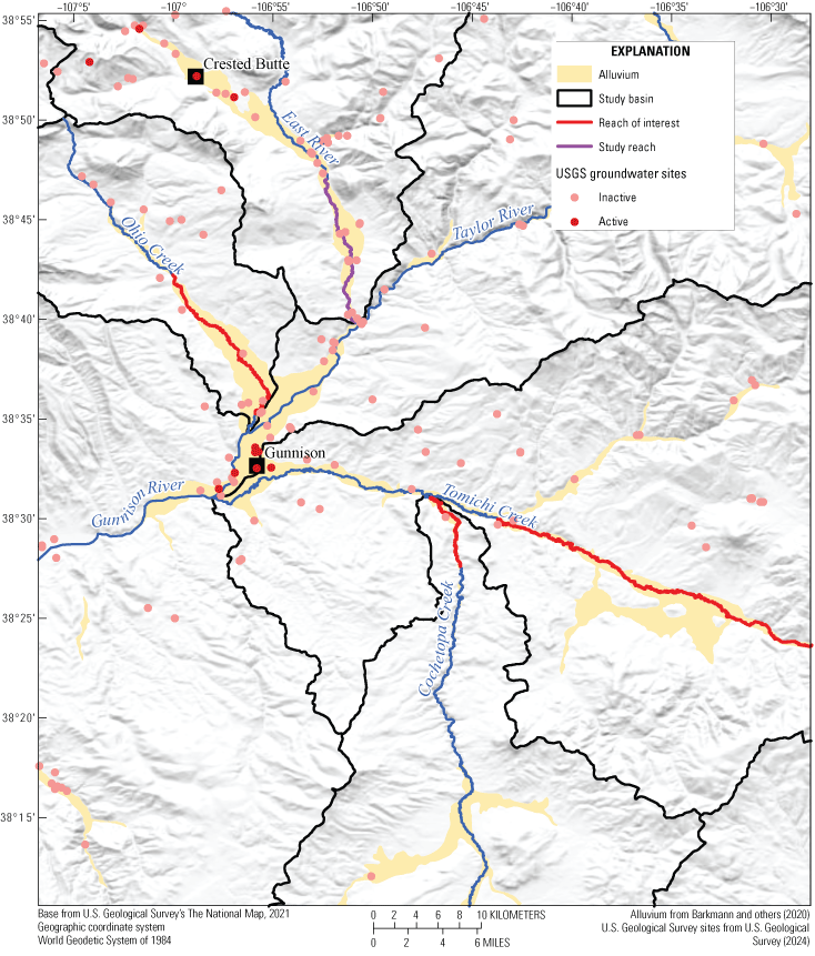
Map showing locations of U.S. Geological Survey (USGS) groundwater sites and alluvium in the study region.
Groundwater-level and chemistry data can provide beneficial information about groundwater recharge and composition. The groundwater monitoring network for this study is planned to consist of 15–20 shallow groundwater monitoring sites—5 near the East River study reach plus additional monitoring sites close to the other reaches of interest to provide information for the Upper Gunnison River Basin and to support potential interpretation and modeling of the other reaches if the study is expanded. There are only four active USGS groundwater monitoring sites in the East River Basin, and all are upstream from the study reach (fig. 2; U.S. Geological Survey, 2024). Other active USGS groundwater monitoring sites are near the city of Gunnison. There are several inactive USGS groundwater monitoring sites near study reaches, and the condition of the wells is unknown. USGS and CDWR records indicate that these inactive groundwater monitoring sites were mainly private wells used for domestic water supply and were not installed by the USGS (Colorado Water Conservation Board and Colorado Division of Water Resources, 2024a). These sites provide good spatial coverage in the East River Basin, but there are fewer sites along the other study reaches. Most of the sites have only one or two records of groundwater level, typically measured between 1960 and 1990 (U.S. Geological Survey, 2024). Similarly, many of the groundwater monitoring sites have records of only one or two chemistry samples, collected at the time of groundwater-level measurements (U.S. Geological Survey, 2024). The small number of measurements and chemistry samples is not sufficient for meaningful statistical analysis. The USGS groundwater sites contribute to a temporal data gap, where data were collected in the past but are no longer being collected, and a spatial data gap, where data exist but are not sufficient to characterize the study area.
Many other private wells have been installed in the study basins, mainly for domestic water use, and records are available from the CDWR (Barkmann and others, 2020; Colorado Water Conservation Board and Colorado Division of Water Resources, 2024a); however, geophysical logs and groundwater-level measurements are not available for all wells. Private wells, including the inactive USGS groundwater monitoring sites, could be considered for inclusion in a monitoring network if access permissions are obtained and the condition of the wells is evaluated and deemed acceptable for use in the study. However, gaining reliable access to private wells can be challenging and could present problems for consistent data collection. If wells are not accessible or not in usable condition, new shallow groundwater monitoring sites could be installed.
In addition to evaluating existing groundwater monitoring sites or installing new sites as necessary, data gaps could be addressed by completing pumping tests to gather data on aquifer properties. Small-scale slug and single-well pumping tests could be completed to quantify variability in hydrologic properties within individual study reaches (Kruseman and de Ridder, 1970). Larger-scale, multiwell pumping tests could be completed if the study is expanded beyond the East River study reach.
Precipitation and Evapotranspiration
In addition to datasets associated with the East River Watershed Function Scientific Focus Area (Kakalia and others, 2021; de Boer and others, 2023), data on precipitation, ET, and climate are collected by other monitoring sites within the basins (for example, U.S. Department of Agriculture Natural Resources Conservation Service, 2024; Colorado Agricultural Meteorological Network, 2024) and remote sensing (for example, Funk and others, 2015; Climate Hazards Center, 2024; NASA, 2024). On-the-ground precipitation data are available from the Natural Resources Conservation Service Snow Telemetry Network (SNOTEL) stations, which measure accumulated precipitation, snow depth, snow water equivalent, and temperature. Two SNOTEL stations are near the East River (station numbers 737 and 380), and the Tomichi Creek and Cochetopa Creek Basins each have one SNOTEL station (station numbers 701 and 1059, respectively; fig. 1). All four stations are located upstream from the study reaches and at higher elevations (fig. 1; U.S. Department of Agriculture Natural Resources Conservation Service, 2024). The Ohio Creek Basin does not have a SNOTEL station. Estimates of precipitation can be obtained from the Climate Hazards Group InfraRed Precipitation with Station dataset, which uses satellite imagery and station data to create gridded precipitation datasets with 0.5×0.5-degree resolution and multiple time steps, including daily (Funk and others, 2015; Climate Hazards Center, 2024).
Estimating ET is important for understanding the consumptive use of water by crops (Evenson and others, 2018; Melton and others, 2022). Precipitation, air temperature, humidity, wind speed, and solar radiation are measured at a Colorado Agricultural Meteorological Network (CoAgMet) station located near Gunnison (station GUN01; fig. 1). These measurements are used in the CoAgMet crop water use tool to estimate ET for a variety of crop types with user-selected planting dates and a modified Penman method (Colorado Agricultural Meteorological Network, 2024). This station is near Ohio Creek and may not be representative of conditions in the other study basins, which do not have CoAgMet stations.
Other sources for ET data are the Moderate Resolution Imaging Spectroradiometer and the OpenET platform. The Moderate Resolution Imaging Spectroradiometer uses satellite data and the Penman-Monteith equation to estimate ET for 8-day, monthly, or annual intervals with a spatial resolution of 0.5 kilometer (NASA, 2024). OpenET provides satellite-based ET data for the Western United States calculated at the field scale, with a spatial resolution of 30 m×30 m. The platform provides ET values computed at daily, monthly, and annual time steps with widely used models and a single ensemble value of ET (Melton and others, 2022; OpenET, 2023). Comparison of OpenET data with ground-based estimates throughout the United States showed strong overall agreement (Melton and others, 2022). The use of satellite-based data allows for estimating ET across larger areas than the site-specific estimates provided by stations such as CoAgMet (Evenson and others, 2018; Melton and others, 2022).
Data Gaps for Estimation of Agricultural Return Flows
Data gaps exist in each study basin and could be addressed to improve the estimation of agricultural return flows (table 3) through endmember mixing analysis (Christophersen and Hooper, 1992) and development of a groundwater model to simulate surface-water and groundwater interactions (Bakker and others, 2016; Leaf and Fienen, 2022). The East River is the focus area of this study and has fewer data gaps than the other reaches of interest because of existing monitoring sites (U.S. Geological Survey, 2024) and modeling that has been done in the East River Basin (for example, Carroll and others, 2023, 2024). Some data gaps could be addressed by installing new streamgages or by making regular streamflow measurements on selected tributaries and irrigation ditches. Because most of the USGS groundwater sites in the area are inactive and have unknown conditions, installation of new groundwater sites may be needed. Installing new surface-water or groundwater sites and accessing privately owned land to make measurements require landowner permissions, which could be a limiting factor in collecting data.
Table 3.
Data gaps for estimating agricultural return flows in the study basins.[NA, not applicable; X, data gap has been identified for the basin]
Summary
The Gunnison River and tributaries in the Upper Gunnison River Basin provide water to irrigate agricultural crops. In some areas, the application of irrigation water can recharge aquifers locally by water percolating below the root zone and eventually flowing back to the stream or river through the subsurface. Diverting surface water for irrigation reduces streamflow during the irrigation season but can provide temporary storage of water and supplement streamflow after the snowmelt runoff season. Understanding the timing and quantity of agricultural return flows could help resource managers make informed decisions and adapt to potential changes in water management and availability that could affect irrigation practices.
In 2024, the U.S. Geological Survey (USGS) began a study, in cooperation with the Upper Gunnison River Water Conservancy District, to characterize surface water and groundwater interactions, specifically agricultural return flows along an East River study reach, in the Upper Gunnison River Basin, Colorado. The study objectives are to complete an endmember mixing analysis to estimate the timing and amounts of agricultural return flow and to create a groundwater model to simulate recharge, discharge to surface water, and surface-water and groundwater interactions. Although the East River is the focus of this study, work could be expanded to other basins in the future, and reaches of interest have been identified on Ohio Creek, Tomichi Creek, and Cochetopa Creek.
This report describes available information and data gaps for modeling groundwater and surface water interactions, specifically the estimation of agricultural return flows, in the East River, Ohio Creek, Tomichi Creek, and Cochetopa Creek. Multiple sources of information related to precipitation and evapotranspiration are available and could be used in modeling agricultural return flows. The East River study reach has USGS streamgages at its upstream and downstream ends. The absence of USGS streamgages with sensors to monitor water temperature and specific conductance are data gaps for the other reaches of interest. In all the study basins, the lack of data on irrigation diversions, tail water return flows, and tributary flows is a data gap. Other data gaps related to groundwater are the lack of active USGS groundwater monitoring sites near the East River study reach and the other reaches of interest, the unknown condition of inactive monitoring sites, and the lack of data on aquifer properties. Surface-water data gaps could be addressed by installing new monitoring sites and by making regular flow measurements on selected tributaries and irrigation ditches. Groundwater data gaps could be addressed by installing new monitoring sites, evaluating existing sites, and completing pumping tests to characterize aquifer properties.
References Cited
Bakker, M., Post, V., Langevin, C.D., Hughes, J.D., White, J.T., Starn, J.J., and Fienen, M.N., 2016, Scripting MODFLOW model development using Python and FloPy: Ground Water, v. 54, no. 5, p. 733–739, accessed February 20, 2024, at https://doi.org/10.1111/gwat.12413.
Barkmann, P.E., Broes, L.D., Palkovic, M.J., Hopkins, J.C., Bird, K.S., Sebol, L.A., and Fitzgerald, F.S., 2020, ON-10 Colorado Groundwater Atlas: Colorado Geological Survey web page, accessed July 26, 2024, at https://coloradogeologicalsurvey.org/water/colorado-groundwater-atlas/.
Bureau of Reclamation, 2012, Colorado River Basin water supply and demand study—Executive summary: Bureau of Reclamation, 28 p., accessed June 10, 2024, at https://www.usbr.gov/watersmart/bsp/docs/finalreport/ColoradoRiver/CRBS_Executive_Summary_FINAL.pdf.
Bureau of Reclamation, 2023, Notice of intent to prepare an environmental impact statement and notice to solicit comments and hold public scoping meetings on the development of post-2026 operational guidelines and strategies for Lake Powell and Lake Mead: Federal Register, v. 88, no. 116, p. 39455–39458, accessed July 1, 2023, at https://www.federalregister.gov/documents/2023/06/16/2023-12923/notice-of-intent-to-prepare-an-environmental-impact-statement-and-notice-to-solicit-co mments-and.
Carroll, R.W.H., Bearup, L.A., Brown, W., Dong, W., Bill, M., and Williams, K.H., 2018, Factors controlling seasonal groundwater and solute flux from snow-dominated basins: Hydrological Processes, v. 32, no. 14, p. 2187–2202, accessed May 22, 2024, at https://doi.org/10.1002/hyp.13151.
Carroll, R.W.H., Deems, J.S., Niswonger, R., Schumer, R., and Williams, K.H., 2019, The importance of interflow to groundwater recharge in a snowmelt-dominated headwater basin: Geophysical Research Letters, v. 46, no. 11, p. 5899–5908, accessed May 22, 2024, at https://doi.org/10.1029/2019GL082447.
Carroll, R.W.H., Gochis, D., and Williams, K.H., 2020a, Efficiency of the summer monsoon in generating streamflow within a snow‐dominated headwater basin of the Colorado River: Geophysical Research Letters, v. 47, no. 23, article e2020GL090856, 10 p., accessed September 17, 2024, at https://doi.org/10.1029/2020GL090856.
Carroll, R.W.H., Manning, A.H., Niswonger, R., Marchetti, D., and Williams, K.H., 2020b, Baseflow age distributions and depth of active groundwater flow in a snow‐dominated mountain headwater basin: Water Resources Research, v. 56, no. 12, article e2020WR028161, 19 p., accessed May 22, 2024, at https://doi.org/10.1029/2020WR028161.
Carroll, R.W.H., Niswonger, R.G., Ulrich, C., Varadharajan, C., Siirila-Woodburn, E.R., and Williams, K.H., 2023, Groundwater and surface water flow (GSFLOW) model files for the East River, Colorado: Water Function SFA ESS-DIVE repository, accessed November 14, 2024, at https://doi.org/doi:10.15485/1998576.
Carroll, R.W.H., Niswonger, R.G., Ulrich, C., Varadharajan, C., Siirila-Woodburn, E.R., and Williams, K.H., 2024, Declining groundwater storage expected to amplify mountain streamflow reductions in a warmer world: Nature Water, v. 2, no. 5, p. 419–433, accessed May 23, 2024, at https://doi.org/10.1038/s44221-024-00239-0.
Christophersen, N., and Hooper, R.P., 1992, Multivariate analysis of stream water chemical data—The use of principal components analysis for the end-member mixing problem: Water Resources Research, v. 28, no. 1, p. 99–107, accessed February 20, 2024, at https://doi.org/10.1029/91WR02518.
Climate Hazards Center, 2024, Climate Hazards Center InfraRed Precipitation with Station data (CHIRPS): University of California, Santa Barbara Climate Hazards Center web page, accessed November 14, 2024, at https://www.chc.ucsb.edu/data.
Colorado Agricultural Meteorological Network, 2024, Evapotranspiration: Colorado State University—Colorado Climate Center website, accessed September 17, 2024, at https://coagmet.colostate.edu/et_main.php.
Colorado Water Conservation Board and Colorado Division of Water Resources, 2016, Gunnison River Basin water resources planning model user’s manual: Colorado’s Decision Support Systems, 221 p., accessed June 2024 at https://dnrweblink.state.co.us/cwcb/0/doc/200073/Electronic.aspx?searchid=d8eca6f8-7cfe-4ddf-9788-5886fd932c8c.
Colorado Water Conservation Board and Colorado Division of Water Resources, 2021, Division 4—Gunnison: Colorado’s Decision Support Systems geodatabase, accessed March 2024 at https://cdss.colorado.gov/gis-data/division-4-gunnison.
Colorado Water Conservation Board and Colorado Division of Water Resources, 2023, GIS data by category—DWR irrigation ditches: Colorado’s Decision Support System geodatabase, accessed March 2024 at https://cdss.colorado.gov/gis-data/gis-data-by-category.
Colorado Water Conservation Board and Colorado Division of Water Resources, 2024a, CDSS data & tools: Colorado’s Decision Support Systems web page, accessed November 14, 2024, at https://dwr.state.co.us/Tools.
Colorado Water Conservation Board and Colorado Division of Water Resources, 2024b, StateMod: Colorado’s Decision Support Systems web page, accessed November 14, 2024, at https://cdss.colorado.gov/software/statemod.
de Boer, G., White, A., Cifelli, R., Intrieri, J., Abel, M.R., Mahoney, K., Meyers, T., Lantz, K., Hamilton, J., Curier, W., Sedlar, J., Cox, C., Hulm, E., Riihimaki, L.D., Adler, B., Bianco, L., Morales, A., Wilczak, J., Elston, J., Stachura, M., Jackson, D., Morris, S., Chandrasekar, V., Biswas, S., Schmatz, B., Junyent, F., Reithel, J., Smith, E., Schloesser, K., Kochendorfer, J., Meyers, M., Gallager, M., Longenecker, J., Olheiser, C., Bytheway, J., Moore, B., Calmer, R., Shupe, M.D., Butterworth, B., Helflin, S., Palladino, R., Feldman, D., Williams, K., Pinto, J., Osborn, J., Costa, D., Hall, E., Herrera, C., Hodges, G., Soldo, L., Stierle, S., and Webb, R.S., 2023, Supporting advancement in weather and water prediction in the Upper Colorado River Basin—The SPLASH campaign: Bulletin of the American Meteorological Society, v. 104, no. 10, p. E1853–E1874, accessed December 13, 2024, at https://doi.org/10.1175/BAMS-D-22-0147.1.
Dewitz, J., and U.S. Geological Survey, 2021, National Land Cover Database (NLCD) 2019 products (ver. 2.0): U.S. Geological Survey data release, accessed October 7, 2024, at https://doi.org/10.5066/P9KZCM54.
Evenson, E.J., Jones, S.A., Barber, N.L., Barlow, P.M., Blodgett, D.L., Bruce, B.W., Douglas-Mankin, K., Farmer, W.H., Fischer, J.M., Hughes, W.B., Kennen, J.G., Kiang, J.E., Maupin, M.A., Reeves, H.W., Senay, G.B., Stanton, J.S., Wagner, C.R., and Wilson, J.T., 2018, Continuing progress toward a National assessment of water availability and use: U.S. Geological Survey Circular 1440, 64 p., accessed September 23, 2024, at https://doi.org/10.3133/cir1440.
Ferencz, S.B., and Tidwell, V.C., 2022, Physical controls on irrigation return flow contributions to stream flow in irrigated alluvial valleys: Frontiers in Water, v. 4, article 828099, 17 p., accessed May 2024 at https://doi.org/10.3389/frwa.2022.828099.
Fernald, A.G., Cevik, S.Y., Ochoa, C.G., Tidwell, V.C., King, J.P., and Guldan, S.J., 2010, River hydrograph retransmission functions of irrigated valley surface water-groundwater interactions: Journal of Irrigation and Drainage Engineering, v. 136, no. 12, p. 823–835, accessed May 2024 at https://doi.org/10.1061/(ASCE)IR.1943-4774.0000265.
Fleck, J., and Castle, A., 2022, Green light for adaptive policies on the Colorado River: Water, v. 14, no. 1, 16 p., accessed June 10, 2024, at https://doi.org/10.3390/w14010002.
Funk, C., Peterson, P., Landsfeld, M., Pedreros, D., Verdin, J., Shukla, S., Husak, G., Rowland, J., Harrison, L., Hoell, A., and Michaelsen, J., 2015, The climate hazards infrared precipitation with stations—A new environmental record for monitoring extremes: Scientific Data, v. 2, article 150066, 21 p., accessed October 7, 2024, at https://doi.org/10.1038/sdata.2015.66.
Giles, T.F., 1980, Reconnaissance of ground-water resources in the vicinity of Gunnison and Crested Butte, West-central Colorado: U.S. Geological Survey Open-File Report 80–12, 2 maps, accessed July 23, 2024, at https://doi.org/10.3133/ofr8012.
Gordon, B.L., Paige, G.B., Miller, S.N., Claes, N., and Parsekian, A.D., 2020, Field scale quantification indicates potential for variability in return flows from flood irrigation in the high altitude western U.S.: Agricultural Water Management, v. 232, article 106062, 12 p., accessed July 3, 2024, at https://doi.org/10.1016/j.agwat.2020.106062.
Gunnison Basin Roundtable, 2022, Gunnison Basin implementation plan: Colorado Water Conservation Board, 41 p., accessed November 2023 at https://dnrweblink.state.co.us/cwcbsearch/0/edoc/216709/Gunnison_BIP_Volume1_2022.pdf.
Harbaugh, A.W., 2005, MODFLOW-2005—The U.S. Geological Survey modular ground-water model—The ground-water flow process: U.S. Geological Survey Techniques and Methods book 6, chap. A16, accessed December 12, 2024, at https://doi.org/10.3133/tm6A16.
Hubbard, S.S., Williams, K.H., Agarwal, D., Banfield, J., Beller, H., Bouskill, N., Brodie, E., Carroll, R., Dafflon, B., Dwivedi, D., Falco, N., Faybishenko, B., Maxwell, R., Nico, P., Steefel, C., Steltzer, H., Tokunaga, T., Tran, P.A., Wainwright, H., and Varadharajan, C., 2018, The East River, Colorado, watershed—A mountainous community testbed for improving predictive understanding of multiscale hydrological-biogeochemical dynamics: Vadose Zone Journal, v. 17, no. 1, p. 1–25, accessed July 3, 2024, at https://doi.org/10.2136/vzj2018.03.0061.
Kakalia, Z., Varadharajan, C., Alper, E., Brodie, E.L., Burrus, M., Carroll, R.W.H., Christianson, D.S., Dong, W., Hendrix, V.C., Henderson, M., Hubbard, S.S., Johnson, D., Versteeg, R., Williams, K.H., and Agarwal, D.A., 2021, The Colorado East River community observatory data collection: Hydrological Processes, v. 35, no. 6, article e14243, 11 p., accessed July 3, 2024, at https://doi.org/10.1002/hyp.14243.
Ketchum, D., Hoylman, Z.H., Huntington, J., Brinkerhoff, D., and Jencso, K.G., 2023, Irrigation intensification impacts sustainability of streamflow in the Western United States: Communications Earth & Environment, v. 4, article 479, 8 p., accessed January 22, 2024, at https://doi.org/10.1038/s43247-023-01152-2.
Leaf, A.T., and Fienen, M.N., 2022, Modflow-setup—Robust automation of groundwater model construction: Frontiers in Earth Science (Lausanne), v. 10, 11 p., accessed February 20, 2024, at https://doi.org/10.3389/feart.2022.903965.
Lopez, S.F., Knight, J.E., Tilman, F.D., Masbruch, M.D., Wise, D.R., Jones, C.J., and Miller, M.P., 2024, Database of surface water diversion sites and daily withdrawals for the Upper Colorado River Basin, 1980–2022: Scientific Data, v. 11, 10 p., accessed February 26, 2025, at https://doi.org/10.1038/s41597-024-04123-0.
Markstrom, S.L., Hay, L.E., Ward-Garrison, D.C., Risley, J.C., Battaglin, W.A., Bjerklie, D.M., Chase, K.J., Christiansen, D.E., Dudley, R.W., Hunt, R.J., Koczot, K.M., Mastin, M.C., Regan, R.S., Viger, R.J., Vining, K.C., and Walker, J.F., 2012, Integrated watershed-scale response to climate change for selected basins across the United States: U.S. Geological Survey Scientific Investigations Report 2011–5077, 134 p., accessed October 10, 2024, at https://doi.org/10.3133/sir20115077.
Markstrom, S.L., Niswonger, R.G., Regan, R.S., Prudic, D.E., and Barlow, P.M., 2008, GSFLOW—Coupled ground-water and surface-water flow model based on the integration of the Precipitation-Runoff Modeling System (PRMS) and the Modular Ground-Water Flow Model (MODFLOW-2005): U.S. Geological Survey Techniques and Methods book 6, chap. D1, 240 p., accessed December 12, 2024, at https://doi.org/10.3133/tm6D1.
Markstrom, S.L., Regan, R.S., Hay, L.E., Viger, R.J., Webb, R.M., Payn, R.A., and LaFontaine, J.H., 2015, PRMS-IV, the precipitation-runoff modeling system, version 4: U.S. Geological Survey Techniques and Methods book 6, chap. B7, 158 p., accessed December 12, 2024, at https://doi.org/10.3133/tm6B7.
Melton, F.S., Huntington, J., Grimm, R., Herring, J., Hall, M., Rollison, D., Erickson, T., Allen, R., Anderson, M., Fisher, J.B., Kilic, A., Senay, G.B., Volk, J., Hain, C., Johnson, L., Ruhoff, A., Blankenau, P., Bromley, M., Carrara, W., Daudert, B., Doherty, C., Dunkerly, C., Friedrichs, M., Guzman, A., Halverson, G., Hansen, J., Harding, J., Kang, Y., Ketchum, D., Minor, B., Morton, C., Ortega-Salazar, S., Ott, T., Ozdogan, M., ReVelle, P.M., Schull, M., Wang, C., Yang, Y., and Anderson, R.G., 2022, OpenET—Filling a critical data gap in water management for the Western United States: Journal of the American Water Resources Association, v. 58, no. 6, p. 971–994, accessed September 11, 2024, at https://doi.org/10.1111/1752-1688.12956.
National Aeronautics and Space Administration [NASA], 2024, MODIS land—Evapotranspiration: National Aeronautics and Space Administration web page, accessed October 7, 2024, at https://modis-land.gsfc.nasa.gov/ET.html.
Niswonger, R.G., Panday, S., and Ibaraki, M., 2011, MODFLOW-NWT, a Newton formulation for MODLFOW-2005: U.S. Geological Survey Techniques and Methods book 6, chap. A37, accessed December 12, 2024, at https://doi.org/10.3133/tm6A37.
OpenET, 2023, OpenET methodologies: Open ET web page, accessed September 11, 2024, at https://openetdata.org/methodologies/.
Peel, M.C., Finlayson, B.L., and McMahon, T.A., 2007, Updated world map of the Köppen-Geiger climate classification: Hydrology and Earth System Sciences, v. 11, no. 5, p. 1633–1644, accessed September 17, 2024, at https://doi.org/10.5194/hess-11-1633-2007.
Robson, S.G., and Banta, E.R., 1995, Ground water atlas of the United States—Arizona, Colorado, New Mexico, Utah: U.S. Geological Survey Hydrologic Investigations Atlas 730–C, 32 p., accessed September 16, 2024, at https://pubs.usgs.gov/ha/ha730/gwa.html.
Schmidt, C., Yackulic, C.B., and Kuhn, E., 2023, The Colorado River water crisis—Its origin and the future: WIREs Water, v. 10, no. 6, article e1672, 11 p., accessed June 10, 2024, at https://doi.org/10.1002/wat2.1672.
Sweetkind, D.S., Masbruch, M.D., Longley, P.C., Smout, B., and Goldberg, J., 2023, Digital hydrogeologic framework model of the Upper Colorado River Basin, Western U.S.: U.S. Geological Survey data release, accessed September 10, 2024, at https://doi.org/10.5066/P96WFS3T.
Tweto, O., 1979, Geologic map of Colorado: U.S. Geological Survey, 1 sheet, scale 1:500,000, accessed September 11, 2024, at https://pubs.usgs.gov/publication/70211263.
Upper Gunnison River Water Conservancy District, 2019, Upper Gunnison River Basin watershed assessment and management planning—Phase I: Colorado Water Conservation Board, prepared by Trout Unlimited, High Country Conservation Advocates, Lake Fork Valley Conservancy, Wilson Water Group, and Alpine Environmental Consulting, 533 p., accessed May 22, 2024, at https://ugrwcd.org/wp-content/uploads/2020/03/191226-CWCB-Final-Report-Phase-I-.pdf.
U.S. Department of Agriculture Natural Resources Conservation Service, 2024, National Water and Climate Center’s snow and water interactive map: Natural Resources Conservation Service web page, accessed September 10, 2024, at https://www.nrcs.usda.gov/resources/data-and-reports/snow-and-water-interactive-map.
U.S. Geological Survey, 2018, Colorado Plateau regional groundwater availability: U.S. Geological Survey web page, accessed August 7, 2024, at https://www.usgs.gov/centers/utah-water-science-center/science/colorado-plateau-regional-groundwater-availability.
U.S. Geological Survey, 2019, StreamStats: U.S. Geological Survey web page, accessed July 22, 2024, at https://streamstats.usgs.gov/ss/.
U.S. Geological Survey, 2024, USGS water data for the Nation: U.S. Geological Survey National Water Information System database, accessed September 19, 2024, at https://doi.org/10.5066/F7P55KJN.
Varadharajan, C., Agarwal, D.A., Brown, W., Burrus, M., Carroll, R.W.H., Christianson, D.S., Dafflon, B., Dwivedi, D., Enquist, B.J., Faybishenko, B., Henderson, A., Henderson, M., Hendrix, V.C., Hubbard, S.S., Kakalia, Z., Newman, A., Potter, B., Steltzer, H., Versteeg, R., Williams, K.H., Wilmer, C., and Wu, Y., 2019, Challenges in building an end-to-end system for acquisition, management, and integration of diverse data from sensor networks in watersheds—Lessons from a mountainous community observatory in East River, Colorado: IEEE Access, v. 7, p. 182796–182813, accessed July 3, 2024, at https://doi.org/10.1109/ACCESS.2019.2957793.
Datums
Horizontal coordinate information is referenced to the World Geodetic System 1984 (WGS 84).
Vertical coordinate information is referenced to the North American Vertical Datum of 1988 (NAVD 88). Elevation, as used in this report, refers to distance above the vertical datum.
Publishing support provided by the Science Publishing Network,
Denver Publishing Service Center
For more information concerning the research in this report, contact the
Director, USGS Colorado Water Science Center
Box 25046, Mail Stop 415
Denver, CO 80225
(303) 236–4882
Or visit the Colorado Water Science Center website at
Disclaimers
Any use of trade, firm, or product names is for descriptive purposes only and does not imply endorsement by the U.S. Government.
Although this information product, for the most part, is in the public domain, it also may contain copyrighted materials as noted in the text. Permission to reproduce copyrighted items must be secured from the copyright owner.
Suggested Citation
Gidley, R.G., Miller, Q.M., and Belcher, W.R., 2025, Data gap analysis for estimation of agricultural return flows in the Upper Gunnison River Basin, Colorado: U.S. Geological Survey Open-File Report 2025-1009, 12 p., https://doi.org/10.3133/ofr20251009.
ISSN: 2331-1258 (online)
Study Area
| Publication type | Report |
|---|---|
| Publication Subtype | USGS Numbered Series |
| Title | Data gap analysis for estimation of agricultural return flows in the Upper Gunnison River Basin, Colorado |
| Series title | Open-File Report |
| Series number | 2025-1009 |
| DOI | 10.3133/ofr20251009 |
| Publication Date | April 14, 2025 |
| Year Published | 2025 |
| Language | English |
| Publisher | U.S. Geological Survey |
| Publisher location | Reston VA |
| Contributing office(s) | Colorado Water Science Center |
| Description | Report: iv, 12 p.; Database |
| Country | United States |
| State | Colorado |
| Other Geospatial | Upper Gunnison River basin |
| Online Only (Y/N) | Y |