

Using High-Resolution Geospatial Imagery and Data To Document the Evolution of the Wilderness Breach That Was Created by Hurricane Sandy in 2012 at Fire Island National Seashore, New York
Links
-
Documents:
- Report (6.57 MB pdf) , HTML , XML
- Report (186 MB pdf) - High-resolution version
- Data Release: USGS data release - Inlet shorelines, Wilderness Breach, Fire Island, NY
- NGMDB Index Page: National Geologic Map Database Index Page (html)
- Download citation as: RIS | Dublin Core
Abstract
The U.S. Geological Survey’s National Civil Applications Center obtained remote sensing data and imagery collected from 1939 through 2023 to monitor changes at Fire Island National Seashore, New York. On October 29, 2012, an inlet was created during Hurricane Sandy on Fire Island that remained open for 10 years. This inlet, named the “Wilderness Breach,” formed at the same location where an inlet had previously existed and remained open from 1763 to 1825. This report documents the morphological changes that occurred at the Wilderness Breach during the 10-year existence of this feature.
Introduction
Fire Island is a 48-kilometer-long barrier island, paralleling the south shore of Long Island, New York, extending from Fire Island Inlet eastward to Moriches Inlet (figs. 1, 2). The coastline is shaped by the interaction of ocean wave erosion and the predominantly westward lateral movement of sediment along the coast from Montauk Point on the eastern headlands of Long Island to Breezy Point Tip on the western end of the island. The central area of Fire Island is a dynamic location, with changes occurring daily as the shoreline is continually shaped and reworked by the lateral current of the Atlantic Ocean.
The study area of this report focuses on the Wilderness Breach, located in the Otis Pike Fire Island High Dune Wilderness area of Fire Island National Seashore. The area is bounded by the Atlantic Ocean on the southeast and Bellport Bay on the northwest, which is in the eastern section of Great South Bay. As required by Public Law 96–585 passed by Congress on December 23, 1980, this section of Fire Island is designated a “wilderness”; the National Park Service maintains its pristine condition and limits human influences.
A study in 1985 estimated that there have been 28 inlets through Fire Island over the past 300 years (Leatherman, 1985). This same study surmised that the most probable place for a future breach on Fire Island was at the Old Inlet location (fig. 2). The Wilderness Breach that formed on October 29, 2012, after Hurricane Sandy passed nearby, existed at the same location that an earlier breach named “The Old Inlet” occupied from 1763 to 1825 (Bolger, 2017). The Old Inlet was navigable and provided a passage for cargo and fishing vessels to travel to and from Bellport and the Atlantic Ocean (Brown, 2013). According to Brown (2013), “Further research via old maps showed that in the 1790’s [sic] it was referred to as ‘The New Inlet at South Haven,’ … gaining the name The Old Inlet only after it was closed by two ship wrecks in the 1820s.” After 1820, the inlet quickly closed through natural sediment transport processes, remaining closed until overwash and erosion from Hurricane Sandy reopened the breach. The dynamics of this section of Fire Island provide an ideal environment for inlet formation and closure.
The dynamics that form and close inlets also influence the morphology and environment of the back bay area behind Fire Island. Shortly after the Wilderness Breach opened in 2012, a flood shoal delta began to form north of the inlet, creating a dynamic feature that morphed and finally stabilized along with the structure of the inlet. The inlet allowed ocean water to mix more easily with brackish bay water, influencing salinity, temperature, and oxygen levels (National Park Service [NPS], 2016a). Remote sensing is an ideal tool for studying these changing features and provides a comprehensive view of their structure and migration through time.
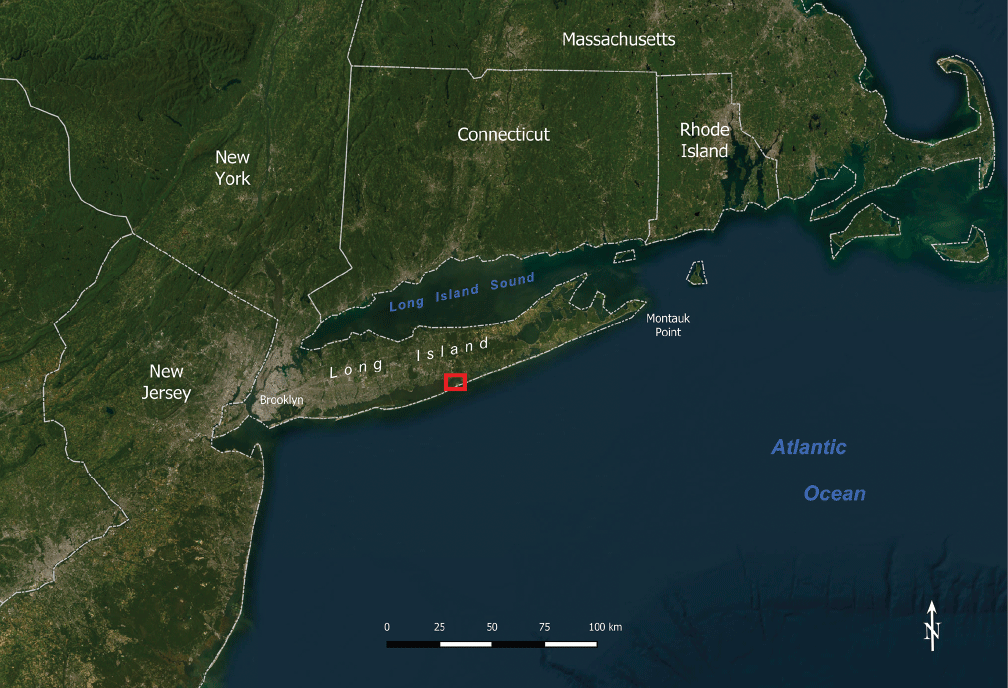
Landsat satellite image showing the location of the study area on Fire Island, which parallels the south shore of Long Island, New York. The red box indicates the study area where an inlet, the Wilderness Breach, formed on October 29, 2012, after Hurricane Sandy passed nearby. The scale bar is in kilometers (km).
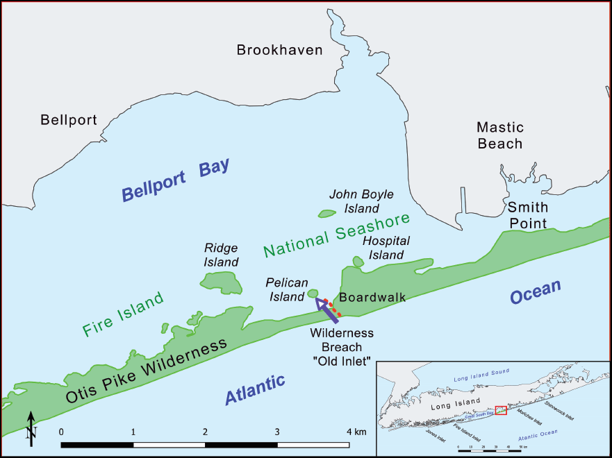
Location map of the study area near the Wilderness Breach on Fire Island, New York. The inset map shows the location of Fire Island parallel to the south shore of Long Island and a red box indicating the study site. The scale bar is in kilometers (km).
Remote Sensing Data
Since the Wilderness Breach formed in 2012, a significant amount of remote sensing data has been collected over the breach. Appendix 1 provides a list of some of the data that are available about this site, and appendix 2 provides the images identified in appendix 1. The U.S. Army Air Corps (predecessor of the U.S. Air Force) collected aerial photography over Fire Island on April 11, 1939. This imagery provides details on how the island looked prior to the changes at Smith Point, just east of the site where the Wilderness Breach occurred (fig. 2.1 in app. 2).
Declassified CORONA and HEXAGON images shown in figures 2.2 and 2.3 in appendix 2 provide a detailed look at the study area during a period of relative stability on the island. The manmade changes at Smith Point are observed upcurrent from the location of the future breach.
The U.S. Geological Survey’s National Civil Applications Center (NCAC) has been collecting high-resolution panchromatic imagery over Fire Island since 1998 as part of the Global Fiducials Library (GFL) program (https://www.usgs.gov/global-fiducials-library-data-access-portal). The GFL is a collaborative effort by Federal civil agencies, academia, and the intelligence community. The goal of the GFL is to build and maintain a long-term record of data over environmentally important sites to support scientists and policymakers.
Analysis of imagery collected during the 14 years prior to November 2012 shows minimum change. The GFL image collected March 8, 2012, is figure 2.4 of appendix 2; it provides a detailed record of the conditions on Fire Island at the Otis Pike Fire Island High Dune Wilderness area prior to the breach being cut across the island in late 2012 during Hurricane Sandy.
This study primarily focuses on commercial high-resolution satellite data collected by Maxar, under contract to the National Geospatial-Intelligence Agency, over the site from 2012 through 2023 (figs. 2.5–2.16 in app. 2). Maxar data are collected by a series of satellites including WorldView–1, WorldView–2, WorldView–3, and GeoEye–1. The satellites collect high-resolution (30 centimeters to 1.23 meters ground sample distance) panchromatic and multispectral imagery (MSI). The resolution of the imagery and systematic collection schedule provided high-resolution data of the area and enabled detailed analysis of features at the site. The MSI proved useful as a tool for highlighting features at the site not readily observable in the true color or panchromatic imagery.
Morphologic Changes
Wilderness Breach Dynamics
WorldView–1 imagery collected over the Wilderness Breach site on November 03, 2012, shows the newly formed inlet measuring a maximum of 72 meters wide (table 1). In order to better understand and document the changes in the inlet, remote sensing data were assembled covering each year from 2012 through 2023. These images were used as a base to provide an annual data source for measuring breach shoreline change during the 10-year existence of the inlet (fig. 3). The shoreline in the breach area was digitized to create a vector line for each year that imagery was collected during the existence of the inlet (Fisher, 2025). The Wilderness Breach opened at the narrowest section of the central part of Fire Island where the low terrain and the absence of dunes provided an ideal path for hurricane overwash and breach formation. A boardwalk (fig. 2) that led from the ocean beach to the back bay near Pelican Island also provided a buffer to channel wave action across this section of the island. The lack of vegetation under the boardwalk may have been a contributing factor to erosion from storm surge washover since there was little vegetation to slow the wave action (Bolger, 2017).
Table 1.
Inlet widths, obtained by using shoreline data, for the Wilderness Breach, Fire Island National Seashore, New York, 2012–2022.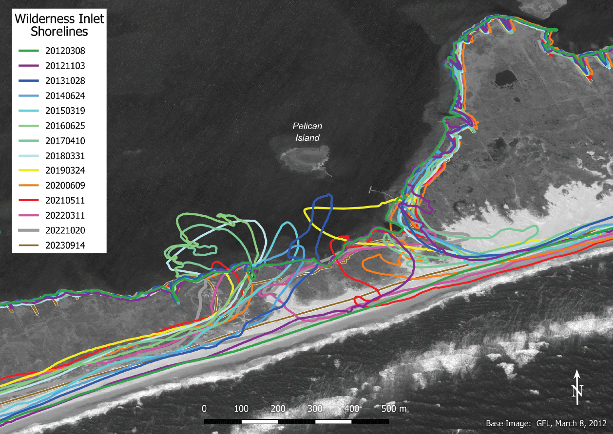
Satellite image map showing shorelines at the Wilderness Breach, Fire Island National Seashore, New York, 2012–2023. The image is from the Global Fiducials Library (https://www.usgs.gov/global-fiducials-library-data-access-portal), and it was collected on March 8, 2012. The scale bar is in meters (m).
The widths of the inlet from 2012 through 2022 are listed in table 1. The width of the inlet for each year was obtained by simply measuring a line on the imagery across the inlet at the narrowest section of the inlet. This technique provided a reliable measurement of the size of the inlet for each year as shown in the imagery. These data reveal that the inlet grew in width during the first 4 years, reaching a maximum width of 440 meters in 2016, when it stabilized. A series of storms in the 2013–2014 winter season affected the inlet (NPS, 2016b), forcing it to migrate to the west and deepening its channel. These changes can be observed in figures 2.6 (October 28, 2013) and 2.7 (June 24, 2014) in appendix 2.
As described by the NPS (2016b), “Longshore transport, also called littoral drift, is one of many natural processes controlling the movement of sediment to, from, and across Fire Island and impacting the barrier island’s shape and position over time.” Prevailing winds flow off the Atlantic Ocean from the southeast toward the northwest. Waves thus typically approach from the southeast and cause sediment to move westward along the ocean side of Fire Island’s shoreline. Processes such as littoral drift and winds cause sand to move and reform the landscape. “Natural processes controlling the shape of the barrier island also influence[d] the shape and position of the wilderness breach” (NPS, 2016b). As a result of natural sediment transport processes and erosion from ocean waves (heightened by storms), the Wilderness Breach migrated west, which is typical of breaches on Long Island. This migration continued through 2017, when the movement stabilized. The migration may have stabilized, but the ocean currents responsible for westward sediment transport did not change.
Flood Shoal Delta Formation
When the Wilderness Breach opened in 2012, sand and sediment were moved from the ocean beach into Great South Bay (fig. 2). Wave energy and currents reworked the sand into flood and ebb shoals, accumulating on the bay side (flood) and ocean side (ebb) of the breach (NPS, 2016b). During the 10-year existence of the breach, these shoals widened the island (fig. 3) and provided platforms for the growth of new salt marshes and other habitats that enhanced the resilience of the barrier island to future storms and sea-level rise. While localized erosion occurred immediately west of the inlet, the ebb shoal that formed on the ocean side remained relatively small and stable, indicating that the breach did not interrupt the sediment transport system. The flood shoal delta that formed on the bay side of the inlet quickly grew in size from 2013 through 2016 (table 2), with the front edge of the delta extending past Ridge Island and John Boyle Island into Bellport Bay (fig. 2). It remained stable until late 2022 when the inlet closed, ending sediment transport into the bay. Between 2020 and December 2023, the area of the flood shoal delta decreased in size from 2,755,327 square meters (m2) to 1,291,971 m2. WorldView MSI was utilized to highlight the flood shoal delta on selected dates from 2013 through 2023 (fig. 4).
Table 2.
Area of flood shoal delta obtained by using vector outline data from multispectral images of the Wilderness Breach, Fire Island National Seashore, New York, 2013–2022.[Multispectral images used to obtain the measurements are in figure 4. GSD, ground sample distance]
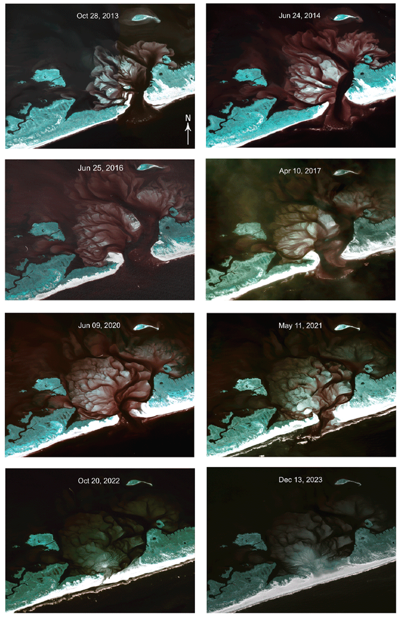
A collection of eight WorldView–2 multispectral images of the flood shoal delta at the Wilderness Breach, Fire Island National Seashore, New York. The images were collected on October 28, 2013; June 24, 2014; June 25, 2016; April 10, 2017; June 9, 2020; May 11, 2021; October 20, 2022; and December 13, 2023. The colors in the multispectral images represent differences in reflectance values of the material that is shown. The benefit of this imagery is being able to clearly see fine-grained material that has a brighter color against more compacted stable material that is highlighted in aqua. White represents a higher reflectance value in the imagery. The brighter white in the imagery represents coarser material such as fine-grained sand particles that do not hold together well and are susceptible to erosion. The light-green coloring represents a more stable landscape that has a healthy vegetation covering that holds the sediment together and will tolerate overwash better than the fine-grained beach material. The reddish-brown coloring represents submerged material that has accumulated in the shoal delta. This material is typically fine grained, loosely distributed, and very susceptible to erosion and movement during wave or tidal flow changes.
Analysis of the MSI data was done by using several modules (tools) available through the Orfeo ToolBox program. This program provided a method to manipulate the bands in the data through an extension in QGIS. This was done to highlight submerged topographic features and enhance the clarity of the data. This was performed by reordering the bands to highlight submerged features (bands 3-green, 2-blue, 1-coastal) and applying a contrast stretch to spread the values over a wider spectrum to enhance the dynamic range of the imagery. This results in a clearer image providing higher details of the submerged features in the flood shoal delta. This method proved to be robust for highlighting features normally obscured by the murky water in the bay.
Outlines for the flood shoal delta were obtained by using the “Line Segment Detection” module in the Orfeo ToolBox program. This application detects linear features in imagery by computing gradient and level lines to detect aligned points in a region. This provided a semi-automated method to digitize the outlines of the flood shoal delta for the dates of interest. The vector lines generated from this process were used to calculate the area of the flood shoal delta.
These images reveal that while the overall shape and morphology of the flood shoal delta remained constant, the area and extent of the feature changed over time in relation to the size of the inlet opening that provided sediment to allow this feature to grow or shrink in size. Once the Wilderness Breach began to close in 2022, the flood shoal delta correspondingly began to shrink.
A comparison of tide gage data from before and after the breach opened indicates that the changes in mean high water levels are small relative to the normal tidal range (NPS, 2016c). Water levels near the breach increased less than 2.50 centimeters. The tide gage measurements demonstrate that close to the breach, in Bellport Bay, the timing of high and low tides occurred approximately 20–35 minutes earlier in the tidal cycle than before the breach opened. Continuous monitoring of the tides and breach itself consistently showed that the breach in no way contributed to flooding that resulted from several major Nor’easter storms that hit the region (Brown, 2013). The natural stabilization of the breach in 2016 also inhibited storm surge flood water from overwhelming the bay tides. Historical data showed that storm surges and tidal fluctuations during Nor’easter storms in the decade from 2012 to 2022, were in line with historic patterns of beach dynamics for this region. The data also showed that this breach was improving the ecology of the Great South Bay, especially in the eastern section.
Ecological Resilience
The formation of the Wilderness Breach provided a unique opportunity to observe the life cycle of a breach and understand the dynamics of this environment. Breaches are important for bay and barrier island ecosystem function, wherein tide and storm-driven flows flush bay water, increase salinity, dilute contaminants, and provide otherwise unavailable migration pathways for fish and other biota (U.S. Geological Survey, 2019). The fresh exchange of oxygenated water from the Atlantic Ocean into the bay at the Wilderness Breach provided a mechanism to flush the bay of contaminants that chronically plague these waters. In areas north of Bellport Bay, many older houses used septic systems and were not served by municipal wastewater treatment facilities (Schwalm, 2013). Brown and red tides are a byproduct of Long Island’s high population density so close to the coast. Prior to the opening of the breach, the Great South Bay was flushing itself of toxins only once every 100 days (Schwalm, 2013). With the opening of the Wilderness Breach providing an infusion of turbulent water from the Atlantic Ocean, the flush rate dropped to once every 40 days. With the closure of the inlet in late 2022, it remains to be seen if the health of bay waters returns to their pre-Hurricane Sandy levels.
Results and Discussion
Remote sensing data collected over Fire Island has provided an 84-year time-series of observations of the ever-changing dynamics of the island and the formation and demise of the Wilderness Breach inlet that occurred there. The formation of the Wilderness Breach in 2012 provided scientists with a unique opportunity to monitor and study the full existence of a barrier island breach. Remote sensing data is a valuable tool to study the dynamics of this feature and how it impacted the surrounding environment. The health of the waters in Bellport Bay can be directly observed in the clarity of the multispectral imagery collected over that region. The flood shoal delta that formed behind the Wilderness Breach in 2013 highlighted the behavior of the tidal waters that flowed in and out of Bellport Bay through the breach. Longshore sediment, being transported to the west, initially collected in the inlet and was pushed shoreward by ocean waves. The flood shoal delta grew until it reached an equilibrium with the amount of sediment being transported into the bay and out during the daily tidal cycle. Likewise, the western side of the inlet shoreline grew until it reached an equilibrium with the amount of laterally deposited sediment that was being transported southwestward along the shore. This equilibrium allowed the sediment to gradually be deposited on the east side of the inlet, until it enabled the shoreline to expand southwestward, closing off the inlet. Even during a period of frequent major Nor’easter storms that caused extensive erosion of the shoreline, lateral transport of sediment allowed the inlet to be sealed shut, resulting in a contiguous shoreline once again. Given the delicate nature of this location and the vulnerability of the coast to frequent storms and potential interruptions of lateral sediment transport, it remains to be seen how long this section of shoreline will remain closed. Although the Wilderness Breach has closed, the beach in the area is low in elevation (Hapke and others, 2017) and has a visibly lower profile than before Hurricane Sandy. The area remains a likely site to develop a new breach in the event of future severe storms.
References Cited
Bolger, T., 2017, Fire Island breach stable 5 years after Sandy, study finds: Long Island Press, accessed February 15, 2024, at https://www.longislandpress.com/2017/10/11/fire-island-breach-stable-5-years-after-sandy-study-finds/.
Brown, M., 2013, The New Inlet, then and now: Save the Great South Bay Inc. web page, accessed February 15, 2024, at https://savethegreatsouthbay.org/cleaner-water/the-new-inlet-then-and-now/.
Fisher, G.B., 2025, Inlet shorelines, Wilderness Breach, Fire Island, NY: U.S. Geological Survey data release, https://doi.org/10.5066/P1382HXH.
Hapke, C.J., Nelson, T.R., Henderson, R.E., Brenner, O.T., and Miselis, J.L., 2017, Morphologic evolution of the wilderness area breach at Fire Island, New York: 2012–15: U.S. Geological Survey Open-File Report 2017–1116, 17 p., accessed February 15, 2024, at https://doi.org/10.3133/ofr20171116.
Leatherman, S.P., 1985, Geomorphic and stratigraphic analysis of Fire Island, New York: Marine Geology, v. 63, nos. 1–4, p. 173–195, accessed February 15, 2024, at https://www.sciencedirect.com/science/article/abs/pii/0025322785900830?via%3Dihub.
National Park Service [NPS], 2016a, The Fire Island Wilderness Breach—Ecological resilience in the Great South Bay: National Park Service web page, accessed February 15, 2024, at https://www.nps.gov/articles/the-fire-island-wilderness-breach-ecological-resilience-in-the-great-south-bay.htm.
National Park Service [NPS], 2016b, The Fire Island Wilderness Breach—Shifting shorelines and shoals: National Park Service web page, accessed February 15, 2024, at https://home.nps.gov/articles/the-fire-island-wilderness-breach-shifting-shorelines-and-shoals.htm.
National Park Service [NPS], 2016c, The Fire Island Wilderness Breach—Water quality and levels: National Park Service web page, accessed February 15, 2024, at https://www.nps.gov/articles/the-fire-island-wilderness-breach-water-quality-and-levels.htm.
Schwalm, A., 2013, New Fire Island breach could be beneficial unless government fills it in: Wired.com, January 18, 2013, accessed February 15, 2024, at https://www.wired.com/2013/01/fire-island-breach-helpful/.
U.S. Geological Survey, 2019, Breach evolution—Coastal system change at Fire Island, New York: U.S. Geological Survey website, accessed February 15, 2024, at https://www.usgs.gov/centers/spcmsc/science/breach-evolution-coastal-system-change-fire-island-new-york.
Recommended Reading
Bolger, T., 2012, Long Island barrier beach breaches $7M to fix: Long Island Press, accessed February 15, 2024, at https://archive.longislandpress.com/2012/11/18/long-island-barrier-beach-breaches-7m-to-fix/.
Bolger, T., 2023, Eye on Fire Island—Old Inlet closes anew: Fire Island News, accessed February 15, 2024, at https://www.fireislandnews.com/eye-on-fi/eye-on-fire-island.
Flagg, C.[N.], [undated], Hurricane Sandy’s impact on eastern Fire Island: Stony Brook University library report, 5 p., accessed February 15, 2024, at https://repo.library.stonybrook.edu/xmlui/bitstream/handle/11401/64244/sandy_photos_001.pdf?sequence=1.
Flagg, C.N., AlNajjar, M., McSweeney, J., and Wilson, T., [undated], The Great South Bay Project: Stony Brook University, School of Marine and Atmospheric Sciences website, accessed February 15, 2024, at http://po.msrc.sunysb.edu/GSB/.
Flagg, C.N., Flood, R., and Wilson, R., 2014, The continuing evolution of the Old Inlet breach: Stony Brook University library report, 5 p., accessed February 15, 2024, at https://bpb-us-e1.wpmucdn.com/you.stonybrook.edu/dist/e/5074/files/2021/03/Inlet_Report_11.pdf.
Hinrichs, C., Flagg, C.N., and Wilson, R.E., 2018, Great South Bay after Sandy—Changes in circulation and flushing due to New Inlet: Estuaries and Coasts, v. 41, p. 2172–2190, accessed December 17, 2024, at https://doi.org/10.1007/s12237-018-0423-6.
James, W., 2013, On Long Island coast, An unexpected gift from Hurricane Sandy: The Atlantic, November 2013, accessed February 15, 2024, at https://www.theatlantic.com/national/archive/2013/11/on-long-island-coast-an-unexpected-gift-from-hurricane-sandy/281423/.
Leatherman, S.P., 1989, Role of inlets in geomorphic evolution of the South Shore barriers of Long Island, New York, USA: Environmental Management, v. 13, no. 1, p. 109–115, accessed February 15, 2024, at https://doi.org/10.1007/BF01867592.
National Park Service [NPS], 2013, Status of Old Inlet breach on Fire Island: National Park Service news release, March 27, 2013, accessed February 15, 2024, at https://www.nps.gov/fiis/learn/news/status-of-old-inlet-breach-on-fire-island.htm.
Southbaysail.com, [undated], The breach at Old Inlet—Salinity: Southbaysail.com web page, accessed February 15, 2024, at http://www.southbaysail.com/the-breach-at-old-inlet---salinity.html.
Thrasybule, L., 2016, The Fire Island Wilderness Breach—Help or hindrance?: U.S. Geological Survey web page, accessed November 26, 2024, at https://www.usgs.gov/news/fire-island-wilderness-breach-help-or-hindrance.
U.S. Army Corps of Engineers [USACE], 2019, Fire Island to Montauk Point, NY—Hurricane and storm damage reduction: U.S. Army Corps of Engineers Fact Sheet, accessed February 15, 2024, at https://www.nad.usace.army.mil/Media/Fact-Sheets/Fact-Sheet-Article-View/Article/1862932/fire-island-to-montauk-point-ny/.
U.S. Army Corps of Engineers [USACE], [undated], Fire Island inlet to Montauk Point reformulation study: U.S. Army Corps of Engineers web page, accessed February 15, 2024, at https://www.nan.usace.army.mil/Missions/Civil-Works/Projects-in-New-York/Fire-Island-to-Montauk-Point/.
U.S. Geological Survey, 2017, USGS tracks evolution of a Fire Island hurricane-generated breach: U.S. Geological Survey web page, accessed November 26, 2024, at https://www.usgs.gov/programs/cmhrp/news/usgs-tracks-evolution-fire-island-hurricane-generated-breach.
U.S. Geological Survey, 2019a, Beach change envelope—Coastal system change at Fire Island, New York: U.S. Geological Survey web page, accessed November 26, 2024, at https://www.usgs.gov/centers/spcmsc/science/beach-change-envelope-coastal-system-change-fire-island-new-york.
U.S. Geological Survey, 2019b, Geology and sediment availability—Coastal system change at Fire Island, New York: U.S. Geological Survey web page, accessed November 26, 2024, at https://www.usgs.gov/centers/spcmsc/science/geology-and-sediment-availability-coastal-system-change-fire-island-new-york.
U.S. Geological Survey, 2019c, Hurricane Sandy—Coastal system change at Fire Island, New York: U.S. Geological Survey web page, accessed November 26, 2024, at https://www.usgs.gov/centers/spcmsc/science/hurricane-sandy-coastal-system-change-fire-island-new-york.
U.S. Geological Survey, 2019d, Long-term change—Coastal system change at Fire Island, New York: U.S. Geological Survey web page, accessed November 26, 2024, at https://www.usgs.gov/centers/spcmsc/science/long-term-change-coastal-system-change-fire-island-new-york.
U.S. Geological Survey, 2019e, Nearshore—Coastal system change at Fire Island, New York: U.S. Geological Survey web page, accessed November 26, 2024, at https://www.usgs.gov/centers/spcmsc/science/nearshore-coastal-system-change-fire-island-new-york.
U.S. Geological Survey, 2019f, Oceanside beaches and dunes—Coastal system change at Fire Island, New York: U.S. Geological Survey web page, accessed November 26, 2024, at https://www.usgs.gov/centers/spcmsc/science/oceanside-beaches-and-dunes-coastal-system-change-fire-island-new-york.
U.S. Geological Survey, 2019g, Open ocean/marine—Coastal system change at Fire Island, New York: U.S. Geological Survey web page, accessed November 26, 2024, at https://www.usgs.gov/centers/spcmsc/science/open-oceanmarine-coastal-system-change-fire-island-new-york.
U.S. Geological Survey, 2019h, Other storm impacts—Coastal system change at Fire Island, New York: U.S. Geological Survey web page, accessed November 26, 2024, at https://www.usgs.gov/centers/spcmsc/science/other-storm-impacts-coastal-system-change-fire-island-new-york.
Williams S J., and Foley, M.K., 2007, Recommendations for a barrier island breach management plan for Fire Island National Seashore, including the Otis Pike High Dune Wilderness Area, Long Island, New York: National Park Service Technical Report NPS/NER/NRTR–2007/075, 16 p., accessed February 15, 2024, at https://www.usgs.gov/publications/recommendations-a-barrier-island-breach-management-plan-fire-island-national-seashore. [See also https://npshistory.com/publications/fiis/nrtr-2007-075.pdf.]
Appendix 1. Summary of Imagery Used in This Study and Shown in Appendix 2
Table 1.1.
Details of images provided in appendix 2 to depict the area around the Wilderness Breach, Otis Pike Fire Island High Dune Wilderness, Fire Island National Seashore, New York.[Terms: app., appendix; cm, centimeter; m, meter]
| Figure in app. 2 |
Date image was collected | Image source and sensor system | Resolution, ground sample distance |
|---|---|---|---|
| 2.1 | April 11, 1939, after a category 3 hurricane in 1938 |
U.S. Army Air Corps, aerial photography | Unknown |
| 2.2 | March 11, 1970 | Declassified KH–4B (CORONA) satellite image | 1.82 m |
| 2.3 | September 10, 1982 | Declassified KH–9 (HEXAGON) satellite image | 0.61 m |
| 2.4 | March 08, 2012, before Hurricane Sandy |
Global Fiducials Library panchromatic image | 1 m |
| 2.5 | November 03, 2012, after Hurricane Sandy |
Maxar WorldView–1 panchromatic image | 52 cm |
| 2.6 | October 28, 2013 | Maxar WorldView–2 ortho natural color image | 59 cm |
| 2.7 | June 24, 2014 | Maxar WorldView–2 ortho natural color image | 57 cm |
| 2.8 | March 19, 2015 | Maxar WorldView–2 ortho natural color image | 53 cm |
| 2.9 | June 25, 2016 | Maxar WorldView–2 ortho natural color image | 51 cm |
| 2.10 | April 10, 2017 | Maxar WorldView–2 ortho natural color image | 55 cm |
| 2.11 | March 31, 2018 | Maxar WorldView–3 visible near-infrared image | 40 cm |
| 2.12 | March 24, 2019 | Maxar GeoEye–1 ortho natural color image | 52 cm |
| 2.13 | June 09, 2020 | Maxar WorldView–2 ortho natural color image | 59 cm |
| 2.14 | May 11, 2021 | Maxar WorldView–2 ortho natural color image | 49 cm |
| 2.15 | October 20, 2022 | Maxar WorldView–2 ortho natural color image | 64 cm |
| 2.16 | December 13, 2023 | Maxar WorldView–2 ortho natural color image | 57 cm |
Appendix 2. Remote Sensing Imagery Depicting the Area Around the Wilderness Breach, Fire Island National Seashore, New York
-
• ortho natural color image: “Ortho” means that the imagery has been orthorectified to align with ground features so that it is geometrically correct. “Ortho natural color” means that the image is a natural color image (composed of three color bands) that is geometrically correct.
-
• panchromatic image: A panchromatic image is black and white.
-
• visible near-infrared (VNIR) image: A visible near-infrared image captures light at the visible (400–700 nanometers) and near-infrared (700–1,000 nanometers) wavelength portion of the electromagnetic spectrum. It combines the full visible spectrum with an adjacent portion of the infrared spectrum. The use of enhanced multispectral analysis enables researchers to improve the classification of land and aquatic features.
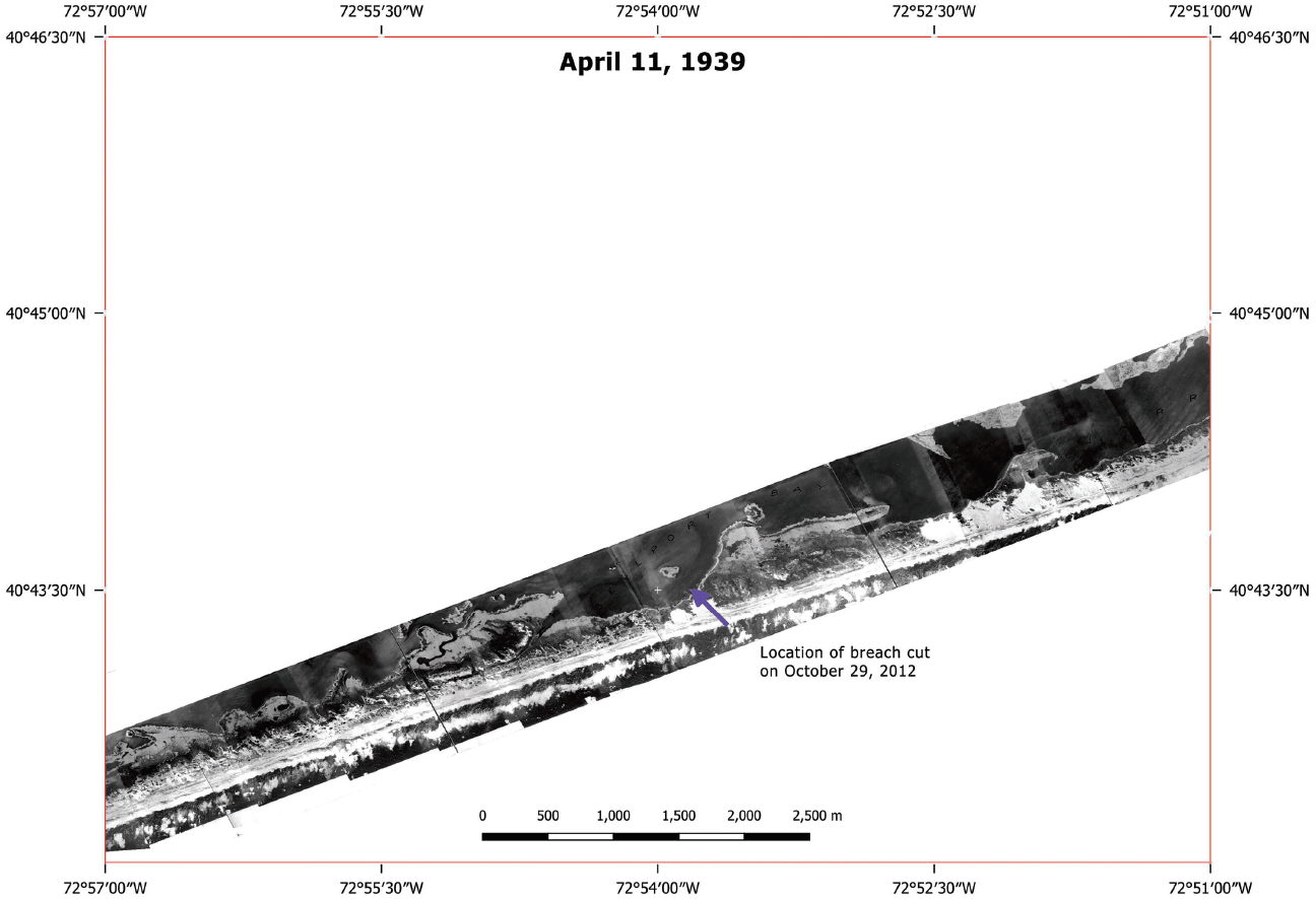
Aerial photography of part of Fire Island National Seashore, New York, collected by U.S. Army Air Corps, April 11, 1939, after a category 3 hurricane hit New York, Long Island, Fire Island, and New England on September 21, 1938. A blue arrow added to the black-and-white photomosaic indicates the location of the Wilderness Breach that cut Fire Island on October 29, 2012. The scale bar is in meters (m). The resolution is unknown.
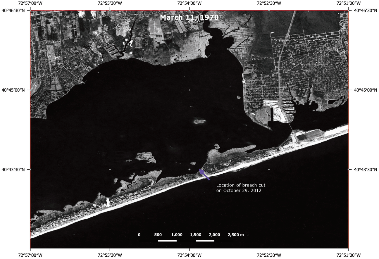
Declassified KH–4B (CORONA) satellite imagery of part of Fire Island National Seashore, New York, collected March 11, 1970. A blue arrow indicates the location of the Wilderness Breach that cut Fire Island on October 29, 2012. The scale bar is in meters (m). The resolution is 1.82 m ground sample distance (GSD).
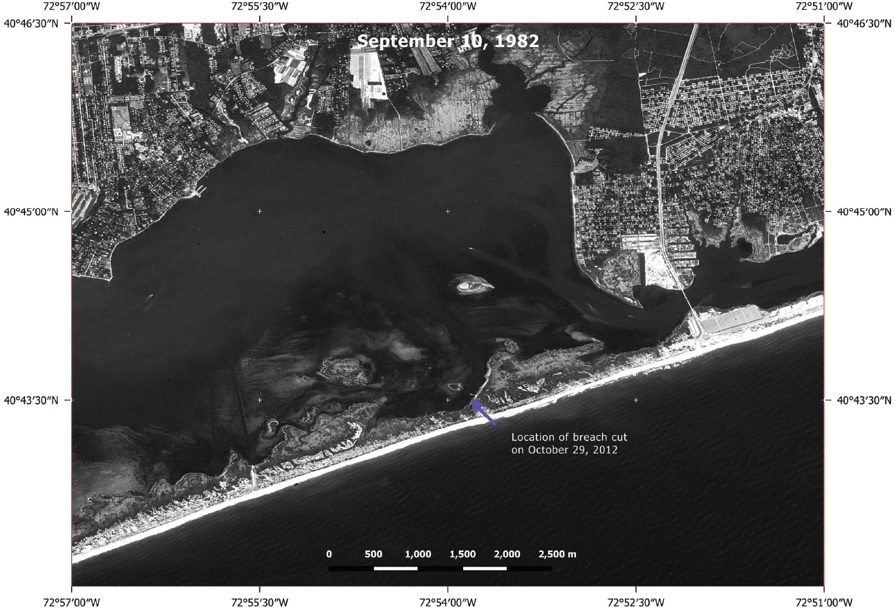
Declassified KH–9 (HEXAGON) satellite imagery of part of Fire Island National Seashore, New York, collected September 10, 1982. A blue arrow indicates the location of the Wilderness Breach that cut Fire Island on October 29, 2012. The scale bar is in meters (m). The resolution is 0.61 m ground sample distance (GSD).
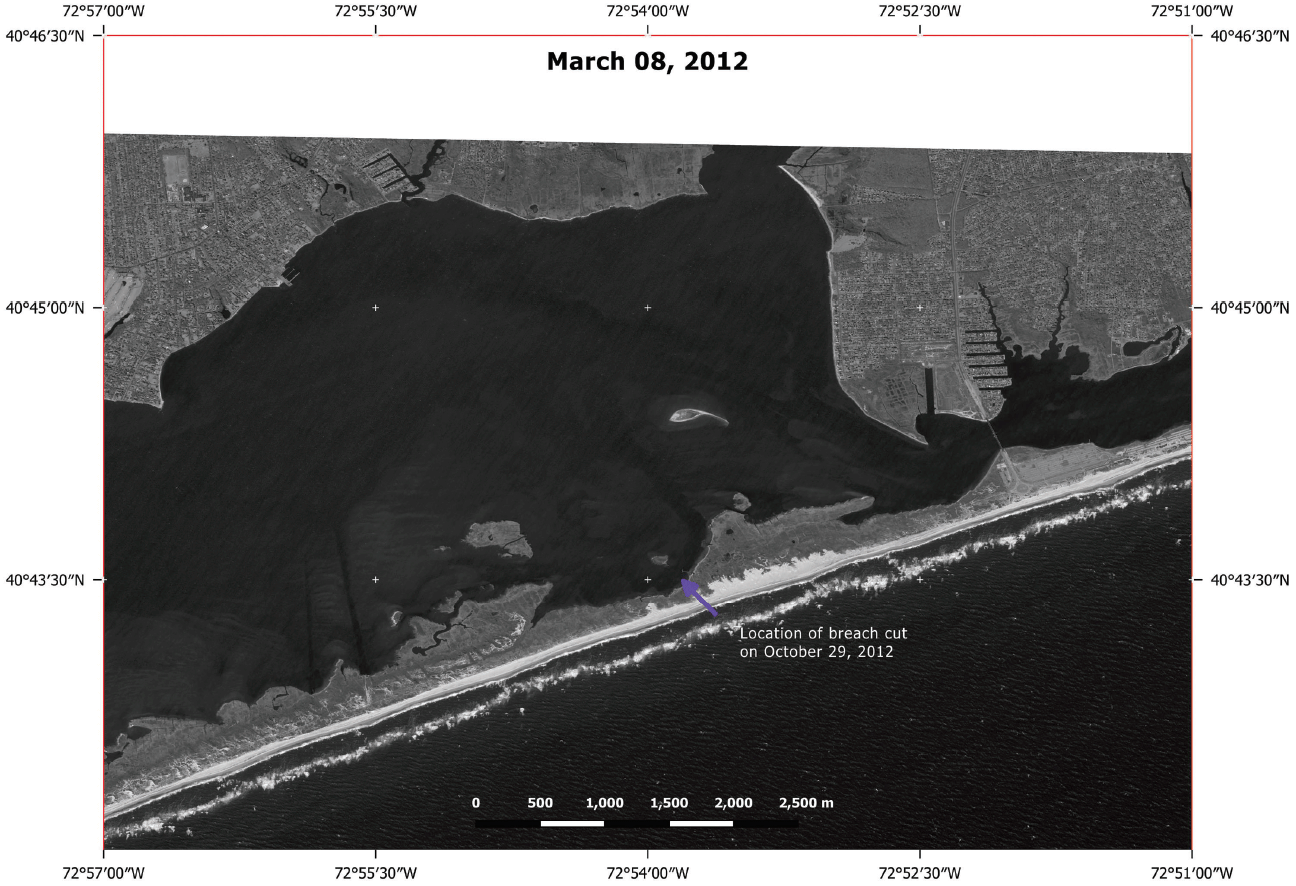
Global Fiducials Library panchromatic imagery of part of Fire Island National Seashore, New York, collected March 08, 2012, before Hurricane Sandy created the Wilderness Breach of Fire Island on October 29, 2012. A blue arrow indicates the location of the Wilderness Breach. The scale bar is in meters (m). The resolution is 1 m ground sample distance (GSD).
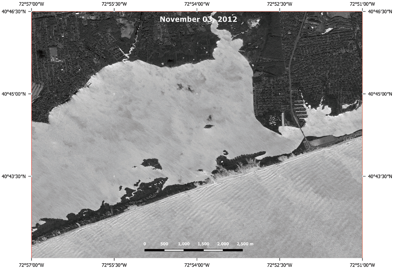
Maxar WorldView–1 panchromatic image of part of Fire Island National Seashore, New York, collected November 03, 2012, after Hurricane Sandy created the Wilderness Breach of Fire Island on October 29, 2012. The scale bar is in meters (m). The resolution is 52 centimeters ground sample distance (GSD).
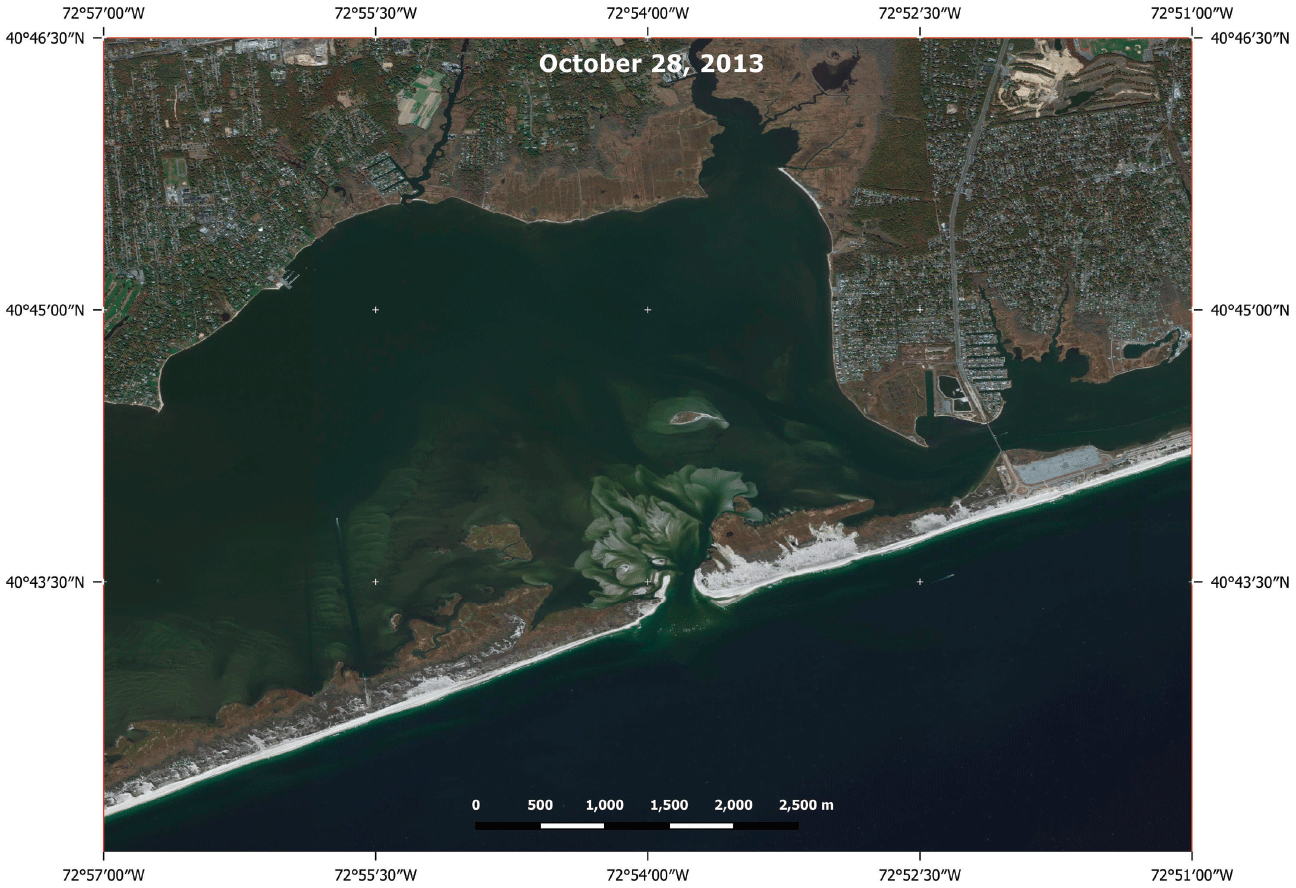
Maxar WorldView–2 ortho natural color image of part of Fire Island National Seashore, New York, collected October 28, 2013. The image shows the flood shoal delta north of the Wilderness Breach. The scale bar is in meters (m). The resolution is 59 centimeters ground sample distance (GSD).
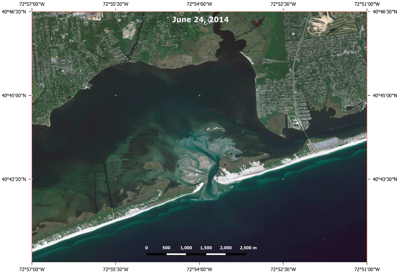
Maxar WorldView–2 ortho natural color image of part of Fire Island National Seashore, New York, collected June 24, 2014. The scale bar is in meters (m). The resolution is 57 centimeters ground sample distance (GSD).
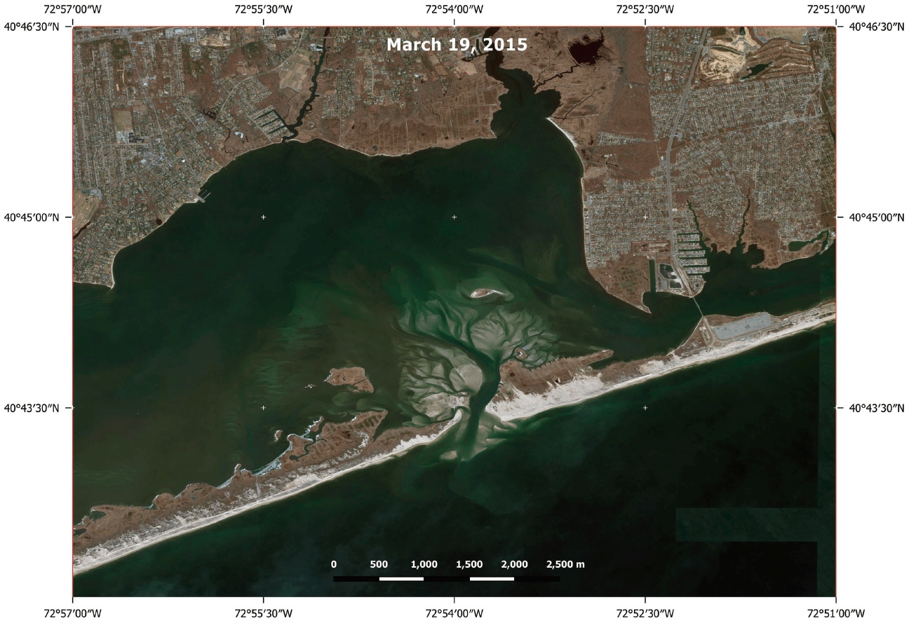
Maxar WorldView–2 ortho natural color image of part of Fire Island National Seashore, New York, collected March 19, 2015. The scale bar is in meters (m). The resolution is 53 centimeters ground sample distance (GSD).
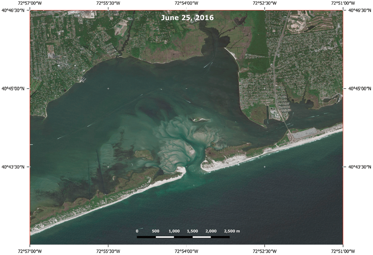
Maxar WorldView–2 ortho natural color image of part of Fire Island National Seashore, New York, collected June 25, 2016. The scale bar is in meters (m). The resolution is 51 centimeters ground sample distance (GSD).
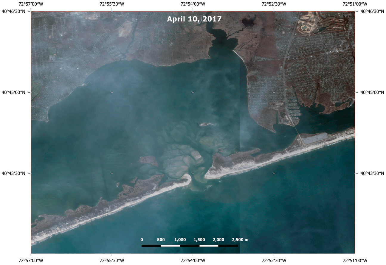
Maxar WorldView–2 ortho natural color image of part of Fire Island National Seashore, New York, collected April 10, 2017. The scale bar is in meters (m). The resolution is 55 centimeters ground sample distance (GSD).
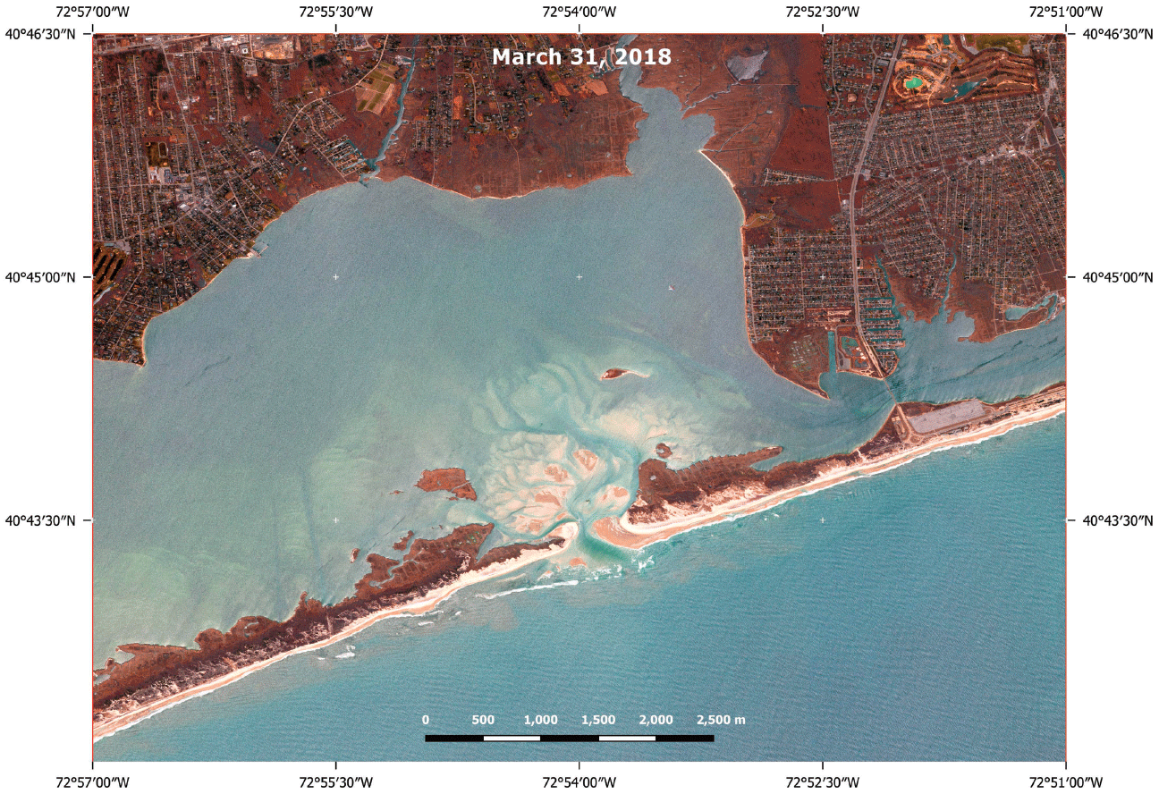
Maxar WorldView–3 visible near-infrared (VNIR) image of part of Fire Island National Seashore, New York, collected March 31, 2018. The scale bar is in meters (m). The resolution is 40 centimeters ground sample distance (GSD).
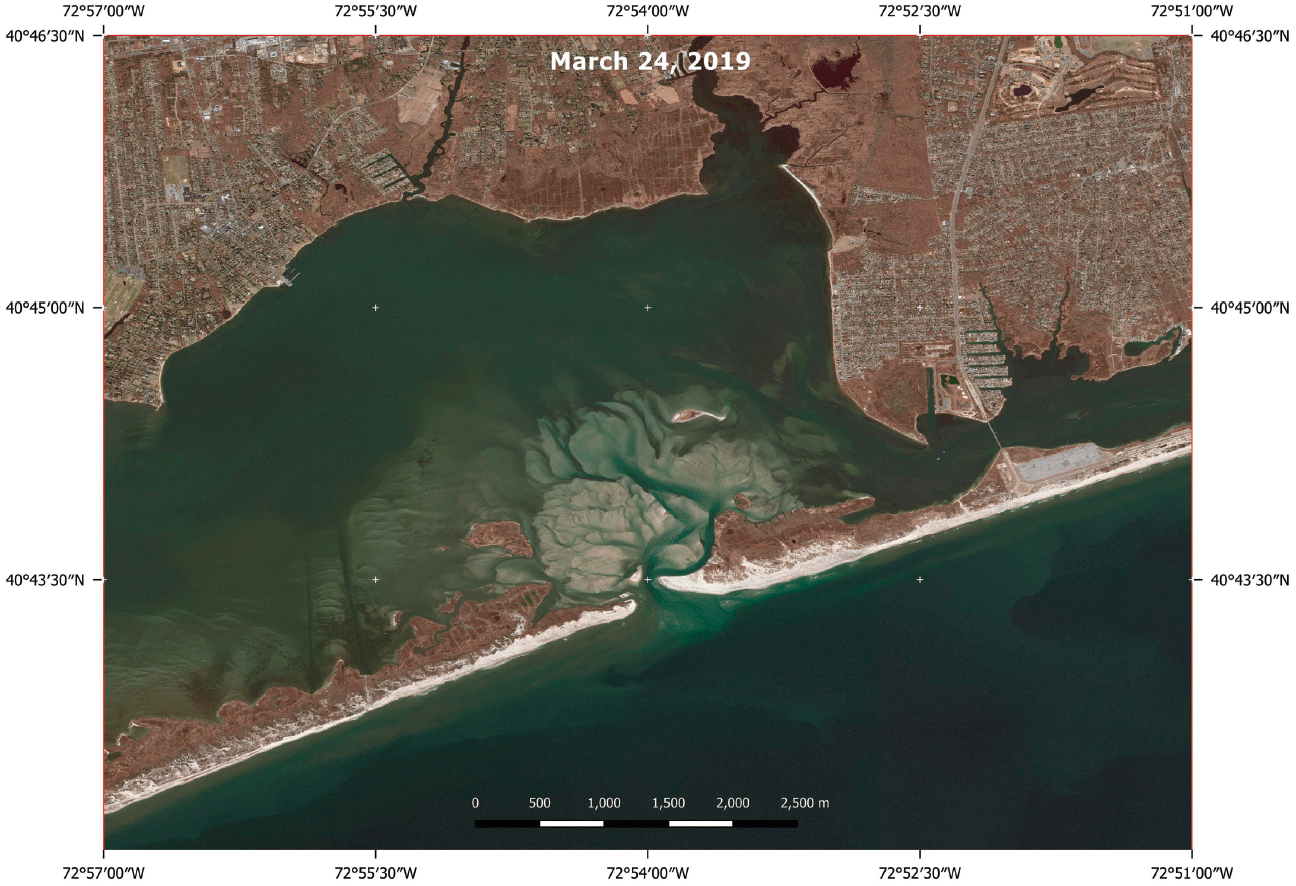
Maxar GeoEye–1 ortho natural color image of part of Fire Island National Seashore, New York, collected March 24, 2019. The scale bar is in meters (m). The resolution is 52 centimeters ground sample distance (GSD).
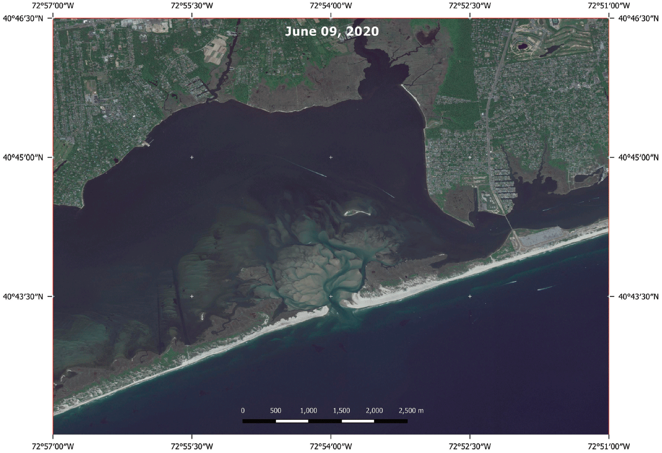
Maxar WorldView–2 ortho natural color image of part of Fire Island National Seashore, New York, collected June 09, 2020. The scale bar is in meters (m). The resolution is 59 centimeters ground sample distance (GSD).
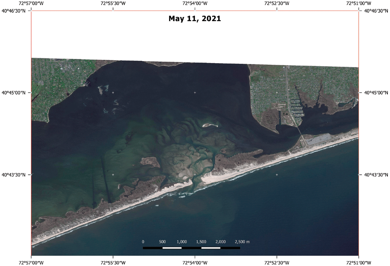
Maxar WorldView–2 ortho natural color image of part of Fire Island National Seashore, New York, collected May 11, 2021. The scale bar is in meters (m). The resolution is 49 centimeters ground sample distance (GSD).
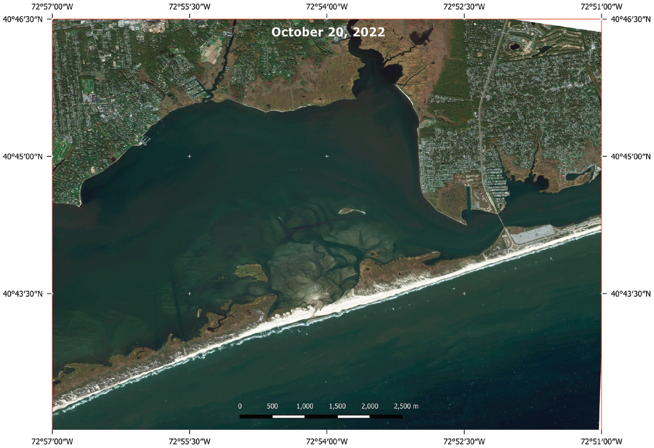
Maxar WorldView–2 ortho natural color image of part of Fire Island National Seashore, New York, collected October 20, 2022. The scale bar is in meters (m). The resolution is 64 centimeters ground sample distance (GSD).
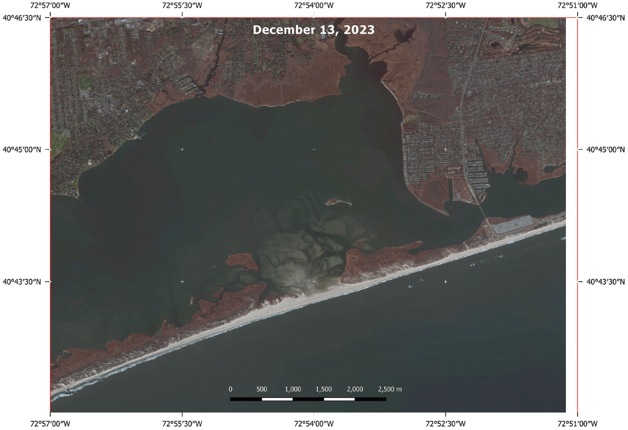
Maxar WorldView–2 ortho natural color image of part of Fire Island National Seashore, New York, collected December 13, 2023. The scale bar is in meters (m). The resolution is 57 centimeters ground sample distance (GSD). The Wilderness Breach had closed in late 2022.
For additional information, contact:
Director, National Civil Applications Center
U.S. Geological Survey
12201 Sunrise Valley Drive, MS 562
Reston, VA 20192
Publishing support provided by the
USGS Science Publishing Network’s
Reston Publishing Service Center,
Sacramento Publishing Service Center, and
Denver Publishing Service Center
Disclaimers
Any use of trade, firm, or product names is for descriptive purposes only and does not imply endorsement by the U.S. Government.
Although this information product, for the most part, is in the public domain, it also may contain copyrighted materials as noted in the text. Permission to reproduce copyrighted items must be secured from the copyright owner.
Suggested Citation
Fisher, G.B., 2025, Using high-resolution geospatial imagery and data to document the evolution of the Wilderness Breach that was created by Hurricane Sandy in 2012 at Fire Island National Seashore, New York: U.S. Geological Survey Open-File Report 2025–1020, 27 p., https://doi.org/10.3133/ofr20251020.
ISSN: 2331-1258 (online)
ISSN: 0196-1497 (print)
Study Area
| Publication type | Report |
|---|---|
| Publication Subtype | USGS Numbered Series |
| Title | Using high-resolution geospatial imagery and data to document the evolution of the Wilderness Breach that was created by Hurricane Sandy in 2012 at Fire Island National Seashore, New York |
| Series title | Open-File Report |
| Series number | 2025-1020 |
| ISBN | 978-1-4113-4607-9 |
| DOI | 10.3133/ofr20251020 |
| Publication Date | May 22, 2025 |
| Year Published | 2025 |
| Language | English |
| Publisher | U.S. Geological Survey |
| Publisher location | Reston, VA |
| Contributing office(s) | National Civil Applications Center |
| Description | Report: iv, 27 p.; Data Release |
| Country | United States |
| State | New York |
| Other Geospatial | Fire Island National Seashore, Wilderness Breach |
| Online Only (Y/N) | N |
| Additional Online Files (Y/N) | Y |