

Grand Canyon River Alert System—Implementing an Emergency Alert System for Wilderness Recreation
Links
- Document: Report (24.9 MB pdf) , HTML , XML
- Download citation as: RIS | Dublin Core
Acknowledgments
The authors gratefully acknowledge the U.S. Geological Survey Community for Data Integration, Risk Research and Applications Community of Practice for providing funding to complete the work presented here as part of the fiscal year 2023 request for proposals. The contributions of the National Weather Service, Coconino County Emergency Management department, and National Park Service staff, including Megan C. Taylor, Brian Klimowski, Joelle A. Baird, Lisa Hendy, Tim Carter, and Wes Dison were greatly appreciated and provided the critical assistance that enabled the launch of the Grand Canyon River Alert System. Special thanks to the participants of the Grand Canyon River Users Stakeholder Workshop and especially to Lynn Hamilton, Executive Director of Grand Canyon River Guides. The authors would also like to thank the reviewers of this manuscript, Eric D. Williams, Marie Peppler, and Sara K. McBride, who helped to greatly improve it.
Any use of trade, firm, or product names is for descriptive purposes only and does not imply endorsement by the U.S. Government.
Abstract
The Grand Canyon River Alert System (GCRAS) provides government-issued emergency alerts to wilderness recreationalists in the Grand Canyon, who are often outside the bounds of cellular signal reception. GCRAS is a collaboration between the U.S. Geological Survey (Grand Canyon Monitoring and Research Center), National Weather Service, Coconino County Emergency Management, and National Park Service. Technological advances in satellite communications have improved satellite signal availability in remote areas and increased the reliability of satellite communications using personal devices such as commercially available satellite messaging devices. These advancements have presented an opportunity to create a novel emergency alert system designed primarily for backcountry visitors to provide improved communications for periods of increased risk and potentially dangerous situations in the backcountry. GCRAS is designed specifically for the distinctive needs of satellite messaging devices and features reduced character count messages, short-code signup capability, and the ability to unsubscribe at any time. After a positive test of the system in March 2024, the system went live to the public and has been used more than two dozen times in 2024 to inform boaters and hikers of hazards (such as debris flows and flash floods) in the Grand Canyon. Satellite signal availability and device response time varies based on location and service provider, but initial testing showed messages arriving within 2–10 minutes. Although GCRAS was developed specifically for the Grand Canyon, the GCRAS framework could be applied to other wilderness areas. It can be used by emergency management authorities, land-management agencies, search and rescue units, and those concerned with public safety to help increase communication with people visiting or living in areas that are outside the signal of more traditional emergency-notification methods, such as cellular, wireless emergency alerts, and sirens.
Introduction
Emergency alerts have been issued by emergency management authorities (EMA) for decades using a variety of mediums, including radio, television, short message service (SMS), email, and more (Moore, 2009, 2010). SMS emergency alerts are commonly issued in areas with cellular signal to disseminate a range of information, including weather forecasts, crime updates, hazard notifications (including for debris flows and flash floods), and event-related information. SMS alert systems commonly send messages to audiences based on either a user’s location or subscription to a list (National Academies of Science, Engineering, and Medicine, 2018). These mass notification systems are commonly used by emergency management departments, State and local governments, and schools and universities to provide alerts to either a user list of subscribers or the general public, regardless of their location (Rave Mobile Safety, 2025a). In contrast, most weather-related SMS alerts are automated and location-based, leading to significant gaps in coverage in areas lacking cellular service.
Every year, more than 1.7 million people spend the night in National Park Service (NPS) managed backcountry wilderness areas, with approximately 740,000 of those nights being in the Mountain West region and Alaska (National Park Service, 2023), where cellular signals are especially weak, sporadic, or entirely absent (Federal Communications Commission, 2022). Safe response to hazards, particularly weather-related hazards, may rest on an individual or group’s preparation and ability to negotiate backcountry conditions. Communication in remote areas, outside of cellular signal coverage, is often limited to satellite phones, radio, emergency transponders, and other long-range communication methods. Recently, emergency satellite transmitters and satellite messaging devices (SMD) have been used more frequently among back-country recreationalists, including those engaged in hiking, backpacking, boating, climbing, and canyoneering.
Although emergency satellite transmitters are primarily designed for outbound communication with search-and-rescue units in life-threatening emergencies, SMDs, which are also emergency satellite transmitters, have additional non-emergency communication capabilities. Depending on the specific device and service provider, SMDs can enable backcountry users to send text messages, check weather reports, and send their current location to friends and family. Messages sent by SMDs are sent as SMS text messages that can be received and replied to by a standard cellular phone. In recent years, signal availability for SMDs has improved as low-earth-orbit satellite networks have become denser. This has enabled messages to be sent and received in short periods of time, even in rugged landscapes like the Grand Canyon region. Adoption of SMDs by backcountry visitors in the Grand Canyon has enabled the development of a unique emergency alert system for those recreating in remote areas.
The Grand Canyon River Alert System (GCRAS) builds off existing SMS subscription-based emergency alert infrastructure but meets the specific needs of SMDs by including a maximum character count, short-code subscription, and character-only messages. This enables EMAs responsible for the Grand Canyon region to send SMS alerts to backcountry recreationalists using SMDs. GCRAS alert messaging is provided by National Weather Service (NWS), NPS, or Bureau of Reclamation staff, depending on the nature of the alert. Alerts are then reviewed and disseminated by Coconino County Emergency Management (CCEM) staff who have the authority to send messages.
One of the challenges in developing GCRAS was establishing a protocol for connecting weather-related emergency alerts with commonly used recreation sites. EMAs responsible for creating and issuing alerts, especially location-based weather alerts, may ignore wilderness areas where cellular signal is not present because of a lack of recipients. Additionally, information specific to recreation, such as locations of commonly used campsites, may not be readily accessible to EMAs. A secondary benefit of developing GCRAS, beyond providing a new method of alerting, has been improved data sharing and communication between organizations that allows for more effective alerts for backcountry recreationalists. U.S. Geological Survey (USGS) Grand Canyon Monitoring and Research Center personnel provided NWS staff with watershed maps, locations of commonly used campsites, and associated river miles (Gushue, 2019; Grams and others, 2024; Byerley and others, 2024; Griffiths and others, 2024). This led to the creation of weather-related alerts not only for specific watersheds, but also by river miles where drainages meet the Colorado River. These alerts help recreational users, who often link river miles to campsite locations, to be better informed of areas that may be susceptible to hazards (such as debris flows and flash floods).
During the initial test of this system for the 2024 commercial river season in the Grand Canyon region, GCRAS improved communication between EMAs and backcountry visitors in the Grand Canyon and was widely adopted by private hikers, private boaters, commercial river companies, and government employees working in the field. Throughout this initial test year, the GCRAS subscription list grew to over 800 individual subscribers. In this report, we further discuss GCRAS’ background and system design as well as the identified issues and limitations realized so far with this system. The goal of GCRAS is not only to provide alerts to backcountry recreationalists in the Grand Canyon but also to serve as a framework for the dissemination of emergency alerts by EMAs in other wilderness areas where SMDs are commonly used.
Background
The Grand Canyon River Alert System (GCRAS) emerged out of a growing awareness of the intersection between weather-related hazards, visitor-use patterns, and advances in satellite communication technologies. Weather-related risks to people in the Grand Canyon can be particularly high at debris fans where tributaries enter the Colorado River corridor (fig. 1). Debris fans are formed by the accumulation of material from repeated debris flows that originate in steep-gradient tributary headwaters (Webb and others, 1989). Debris fans are a focal point for visitors because they create nearly all the large rapids for which the Grand Canyon is famous (Howard and Dolan, 1981). Debris fans are also useful locations for campsites because they provide relatively flat areas for camping in the otherwise steep and rugged canyon environment. Also associated with the debris fans are zones of low streamflow velocity, or eddies, and alluvial sandbars (Schmidt, 1990). Eddies and sandbars provide calm water for boat parking and soft sand for comfortable camping (Hadley and others, 2018). Tributary canyons can also be popular places for hiking. People camping on debris fans may be susceptible to hazards from debris flows and flash floods, which can be especially common when the North American Monsoon (NAM) is active. Known locally as the summer monsoon season, this phenomenon is a seasonal shift in wind patterns occurring typically from July through mid-September in the southwestern United States that can produce brief periods of highly localized and intense rainfall (Adams and Comrie, 1997). These storms can cause flash floods and debris flows that may carry large amounts of mud and boulders onto debris fans, creating potentially dangerous conditions for campers.
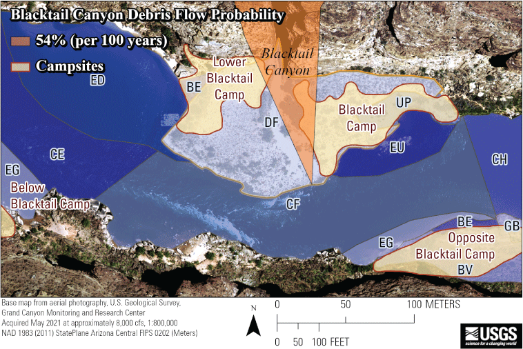
Imagery showing Grand Canyon overlayed with known campsites, Blacktail Canyon drainage, and mapped geomorphic units. These units include undifferentiated eddy bar (BE), vegetated undifferentiated eddy bar (BV), channel adjacent eddy (CE), channel adjacent debris fan (CF), channel (CH), debris fan (DF), eddy downstream from debris fan (ED), eddy associated with gravel bar (EG), eddy upstream from debris fan (EU), gravel bar (GB), and undifferentiated eddy bar upstream from constriction (UP).
In the fall 2022, the USGS began to develop a communication plan to help better inform backcountry recreationalists of the hazards associated with debris flows and flash floods in the Grand Canyon. In September 2023, the USGS organized a Colorado River user stakeholder workshop to help identify the most effective methods of presenting debris flow and flash flood hazard information. Participants included staff from Federal agencies (USGS, NPS and NWS), local emergency management officials (CCEM), Tribal representatives, environmental advocates, private boater association members, and commercial river guides. The USGS presented background information on specific themes that addressed the topic of debris flows and flash floods from different perspectives including geomorphology, mapping, existing datasets, and potential forms of hazard communication. Stakeholders were split into the following breakout groups that aligned with the stakeholders’ expertise: emergency services, recreation, mapping and analysis products, and scientific communication and community outreach. After the breakout sessions concluded, the top three communication ideas from each breakout group were reported to the larger stakeholder group and synthesized to a single list. Dot voting was used to rank potential communication strategies by perceived importance and effectiveness. Each stakeholder was allocated three votes; however, not all stakeholders used the full number of votes available to them. The idea that received the most dot votes was to develop an emergency alert system using SMD transmissions (fig. 2).
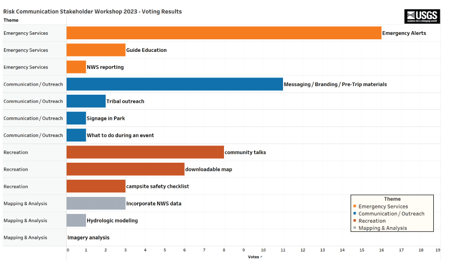
Graph showing dot voting results of individual risk communication topics, grouped by theme, from the Colorado River user-stakeholder workshop in fall 2023.
Building off the stakeholder workshop, the USGS established a working group of EMAs who would be responsible for data sharing, alert development, and alert dissemination to implement an emergency alert system specific to the needs of SMDs and backcountry visitors in Grand Canyon. The group included USGS, NWS, CCEM and NPS staff. The USGS provided expertise in satellite communication technology and applied geospatial data analysis that integrated river campsites, tributary drainages, geomorphic units at campsites, and the Colorado River Mile System to produce more meaningful datasets to be used in the alert system (Gushue, 2019). NWS and CCEM staff provided expertise in emergency alert creation and dissemination. NPS employees provided knowledge of backcountry hazard message development and backcountry recreationalist education.
From December 2023 through March 2024, the working group held a series of meetings to better understand how emergency alerts are generated and distributed by CCEM, what tools CCEM and NWS could use to provide alerts for the Grand Canyon region, and how existing alert-generation practices could be modified to meet the specific needs of SMDs. By March 2024, the GCRAS framework was established, and initial testing of the system was done. All subscribed SMDs received a test alert message within 10 minutes of transmission, although some received the message within 2 minutes. On March 31, 2024, the alert system was presented to the Grand Canyon commercial river guide community at the Grand Canyon River Guides Annual Guide Training Seminar, marking its live deployment.
System Framework
The GCRAS framework uses a modified subscription list method for sending alerts with a defined character count, short-code signup capability, and a focus on highly synthesized information. Although GCRAS caters to the specific needs of SMDs, it is also compatible with standard cellular devices and email addresses, enabling emergency alerts to be received by individuals who are not in the backcountry, such as family members and managers of commercial guide companies. GCRAS is designed to be flexible and compatible with as many devices and service providers as possible; it primarily does this by meeting the needs of devices with the lowest character count per message limitations. By doing so, GCRAS can easily incorporate existing and future forms of satellite-based communication, such as emerging low-earth-orbit cellular technology.
GCRAS uses a subscription-list design because of the challenges of incorporating the geographic position of SMDs with existing location-based emergency alert systems. Traditionally, cellular devices are located automatically based on connections to cellular towers or known locations of individuals (National Academies of Sciences, Engineering, and Medicine, 2018). Alerts are then sent to cellular devices that are within proximity to cellular towers and specifically for areas that may be susceptible to hazards such as debris flows and flash floods. By contrast, identifying the location of SMDs for the purposes of broadcasting emergency alerts can be challenging for several reasons. First, SMD locations are identified using Global Positioning Systems (GPS), but alerting agencies do not readily have access to the location data of these devices. Second, GPS location accuracy decreases in areas where view of the sky is narrow, such as the Grand Canyon, which makes it hard to pinpoint the location of the device accurately in these conditions. Additionally, SMDs have limited battery life, and backcountry recreationalists may keep their device off for most of the day, restricting real-time location identification. By implementing a single subscription-list design, alerts can be sent simultaneously to all those in the backcountry. Although this approach may lead to recreationalists receiving some irrelevant messages, it can help ensure that all subscribed backcountry users receive all alerts. The alerts provide information on conditions across the entire Grand Canyon region, and so these messages will include areas where subscribers are currently traveling or may plan to visit. The combination of a single subscription list and alerts broadcast across the entire region streamlines the communication of alerts and the system design.
Subscribing to GCRAS using a traditional cellular device or email address can be done using the smart911 website or mobile application (Smart911, 2025). However, this subscription method is not compatible with SMDs because of differences in how these devices handle SMS messages. Most SMDs cannot receive an inbound satellite message from a given phone number without first sending an outbound message to that same number. This policy has been enabled by most SMD service providers to prevent spam. Additionally, the phone number associated with an SMD may not be readily known by the user, and if known, the number assigned to a device can change over time. Policies related to phone number consistency vary between service providers. To overcome these challenges, GCRAS implements a short-code signup method (fig. 3). Short codes are low character count words or phrases that when received by a specific phone number trigger an action, such as subscribing or unsubscribing from a list. By sending an outbound short code from an SMD to the GCRAS signup phone number, the SMD is initiating contact and can therefore receive inbound messages from that same number. The GCRAS short-code signups and emergency alert disseminations are conducted by the same phone number.
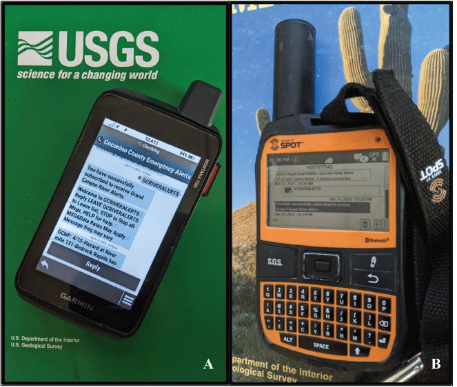
Images of satellite messaging devices showing the subscription signup process for Grand Canyon River Alert System emergency alerts. A, Garmin inReach device, which uses the Iridium satellite network, subscribed to the alert system. B, SPOT device using the Globalstar satellite network and which is also subscribed to the alerts. Photographed images by Thomas M. Gushue of the U.S. Geological Survey.
Message design and character count are critical for effective dissemination of alerts to SMDs. Alerts sent to a phone number associated with an SMD are first run through a filter managed by the satellite service provider. Communications that are from unrecognized phone numbers or are not compatible with SMDs will not reach the device. Non-compatible messages can include those with too many characters, internet links, images, or other non-character content, depending on the satellite service provider. Device users may or may not receive an error message related to an invalid inbound message. The acceptable character count also varies depending on the manufacturer of the device and the service provider. When developing GCRAS, we tested SPOT and Garmin inReach devices, which use the Globalstar and Iridium satellite networks, respectively. SPOT devices were the most limited with respect to message character count. Messages longer than 128 characters were not received. To ensure that all GCRAS-subscribed devices can successfully receive alerts, we have restricted GCRAS alerts to 128 characters (fig. 4). Multiple messages per alert may be utilized if 128 characters are insufficient. An important consideration for this method is that SMDs may occasionally receive inbound messages in an incorrect order. If multiple messages are required, specific message number references are to be added to each message (for example, “1 of 2,” “2 of 2”). References to dates and times of alert events are useful as well. The timestamp for an inbound message on an SMD will reference the time the device received it and not when the alert was issued. Without this function, an alert message from earlier in the day may be received as though it is a current event if a user had powered off their device during the day. Additionally, many SMD service plans limit the number of custom messages that a device can receive before a user incurs an additional charge. GCRAS emergency alerts are considered by service providers to be custom messages and count against a user’s total message limit. Therefore, unless deemed necessary by CCEM, alert messages are restricted to a single 128-character message to reduce the total number of alert messages received.
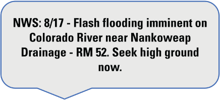
Image showing an alert issued by the National Weather Service on August 17, 2024. Alert message is less than 128 characters and includes the issuing organization, date of event, hazard event, hazard location and call to action.
SMDs commonly receive messages using a mailbox check method. This method involves temporary storage of inbound messages in a virtual mailbox that can be queried by the device and is hosted by satellite service providers. For devices that are always on, this mailbox check may be constantly working in the background, enabling the receipt of real-time messages. When devices are powered down, satellite service providers queue inbound messages in the virtual mailbox until the next time the device is powered on or a mailbox check is requested. At this point, all messages from the last power down will be sent to the device. This behavior may create an issue for recreationalists who choose to turn off their device at the end of a trip and leave it off for several weeks or months after that. GCRAS alert messages may accumulate in the virtual mailbox and result in the device receiving multiple out of date and non-relevant alerts the next time it is powered on. These alerts can count against a user’s custom message count and possibly result in overage fees. Recreationalists can unsubscribe from GCRAS at any time to prevent unwanted messages.
GCRAS messaging is provided by NWS, NPS, or Reclamation officials to CCEM depending on the nature of the event. In general, weather-related hazards are provided by NWS, public safety and boating hazards are provided by NPS, and dam-related issues are provided by Reclamation. All alert messaging is communicated to CCEM, which ensures that the message meets GCRAS specification, including character count and message relevance. CCEM then disseminates the alert message to the GCRAS subscription list (fig. 5). Alert system testing during the 2024 commercial river season yielded more than 24 different alert events, with most of the weather-related alerts pertaining to flash flooding during the North American monsoon season (fig. 6).
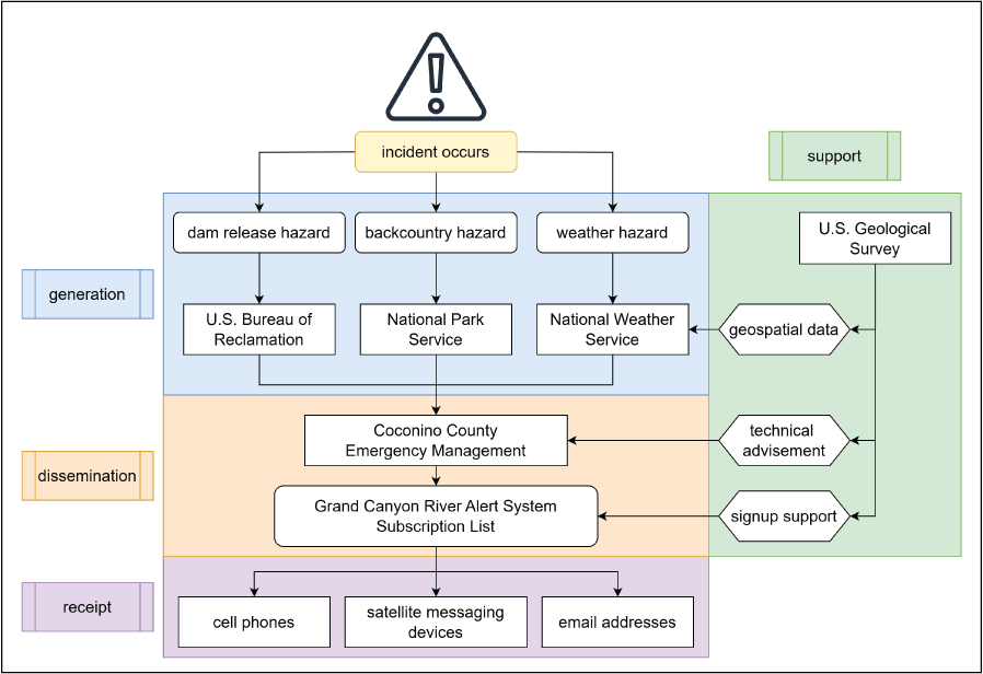
Flowchart showing the types of alerts generated in the Grand Canyon River Alert system, the responsibilities of organizations involved in alert message dissemination, and how the messages can be received.
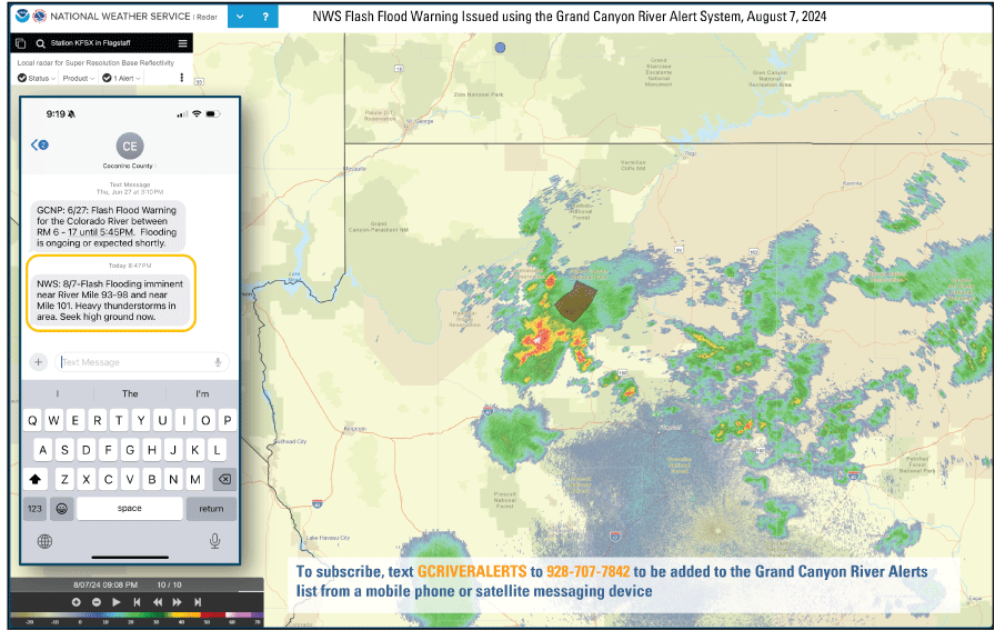
Image of a mobile device alert and map of the Grand Canyon region showing flash-flood warning issued by the National Weather Service using the Grand Canyon River Alert System on August 7, 2024.
System Challenges and Limitations
Developing and implementing GCRAS involved overcoming multiple technical challenges and working across EMA boundaries to enable data sharing and develop standard methods of communicating alerts in the Grand Canyon region. Although GCRAS deployment has been an overall success, the system has several challenges and limitations. These challenges are specific to incorporating SMDs in existing emergency-alert infrastructure and include dealing with message receipt failure, SMD phone number shifts, signal availability, and typical user habits.
A key challenge in incorporating SMDs in a subscription-list design using a short-code signup method is that SMD outbound message format differs between devices and service providers. Short-code processing software used by CCEM telecommunications, and commonly used by alerting agencies across the United States, has very strict character limits. It is possible that some SMDs automatically include additional characters or information in their outbound messages, such as a link to the user’s location or a signature value. If additional characters beyond the short code are sent to the GCRAS signup phone number, list subscription will fail. Users in this case will not receive a response of any kind from the short-code signup phone number. This has the potential to result in users falsely thinking they are signed up for GCRAS. In most cases, these accessory characters attached to outbound SMD messages can be removed by adjusting the device messaging configuration. Once signed up for GCRAS, accessory characters can be reenabled because they do not affect a device’s ability to receive alerts or messages but do affect subscription or cancellation messages. As an example, Garmin InReach devices can now subscribe to GCRAS (as of April 2025) without having to modify device messaging configuration settings through the Garmin website.
Successful receipt of GCRAS alerts depends on an SMD having a static phone number associated with it. This number is recorded by GCRAS during the signup process and alerts are then sent back out to it. If this number changes, the SMD will not receive alert messages and will have to resubscribe to the list. This change may not be apparent to the recreationalist and result in alerts that were unknowingly not received. Different service providers have different policies regarding phone numbers associated with SMDs. Some have a fixed phone number associated with each device that never changes, others change numbers at sporadic intervals, and others maintain fixed phone numbers while a service contract is in place but change numbers when a service contract lapses. Service providers do not advertise how long a phone number is valid for a given SMD, but based on our initial testing, they appear to remain static for at least 30 days. GCRAS allows users to resubscribe at any time to ensure that they will receive alerts if they think their number may have changed.
Although SMDs are designed to work in extremely remote locations such as the Grand Canyon, inherent limitations are associated with them that may prevent a user from receiving GCRAS alerts. Signal availability, especially in narrow canyons, may delay receipt of messages by hours or even days. Most commercially available SMDs are designed with enough battery life to be powered on for multiple days, but a backcountry recreationalist on an extended trip may turn their device on or off at various intervals to prolong battery life. To address this issue, GCRAS issues alerts for immediate hazards and ones that are forecasted. For forecasted hazards, a user can turn on their device once or twice a day and still be informed about pending hazardous weather or conditions through GCRAS.
Conclusions
Although development of the Grand Canyon River Alert System (GCRAS) originated from an effort to help better inform backcountry recreationalists in the Grand Canyon about debris flow and flash flood hazards, this framework could apply to the dissemination of emergency alerts in other wilderness areas across the globe. By tailoring existing emergency alert messaging methods to the specific needs of satellite messaging devices, GCRAS can allow for a new type of technology, satellite messaging devices, to receive emergency alerts, expanding how emergency management authorities can communicate with people in the backcountry. The GCRAS framework includes a subscription-list design, short-code signups, alerts with a limited character count, a focus on hazard proximity to recreation locations, and a simple unsubscribe feature to prevent over-messaging when satellite messaging devices are not in use. GCRAS is designed to increase information sharing between emergency management authorities and backcountry recreationalists and to better inform recreationalists of hazardous situations (including debris flows and flash floods).
The GCRAS was made available as a soft release that recruited subscribers initially through the Grand Canyon River Guides’ association before the beginning of the 2024 commercial river season which goes from April 1 through September 15 in Grand Canyon National Park. Given the importance of this new system, the signup information was shared more widely by the National Park Service (NPS) to private boating permit holders and other recreationalists through informational handouts, signage within Grand Canyon National Park, and through a public-facing NPS web page hosted on Grand Canyon National Park’s website (National Park Service, 2025). After the initial launch of the system on March 31, 2024, NPS disseminated several hazardous condition alerts, including alerts on dangerous obstructions to river travel and missing persons within the park. During the 2024 commercial river season and the initial use of GCRAS, there were a total of 29 alerts issued, with the majority being weather-related alerts of potential or imminent flash flooding issued by the National Weather Service during the summer monsoon season. After the 2024 commercial river season, Coconino County Emergency Management sent out a voluntary feedback survey for subscribers to the GCRAS. The results of the survey can help guide future use of the Grand Canyon River Alert System.
References Cited
Adams, D.K., and Comrie, A.C., 1997, The North American monsoon: Bulletin of the American Meteorological Society, v. 78, no. 10, 17 p., last accessed on June 7, 2024, at https://doi.org/10.1175/1520-0477(1997)078<2197:TNAM>2.0.CO;2.
Byerley, E.P., Gushue, T.M., and Grams, P.E., 2024, Geomorphic attributes of campsites adjacent to the Colorado River in Grand Canyon, AZ: U.S. Geological Survey data release, last accessed on November 19, 2024, at https://doi.org/10.5066/P1CJJPXD.
Federal Communications Commission, 2022, Federal Communications Commission national broadband map: Federal Communications Commission web page, last accessed on June 12, 2024, at https://broadbandmap.fcc.gov.
Grams, P.E., Ross, R.P., Byerley, E.P., and Gushue, T.M., 2024, Geomorphic map of alluvial and tributary deposits for the Colorado River in Grand Canyon, Arizona - May 2009: U.S. Geological Survey data release, https://doi.org/10.5066/P18YVP6Z.
Griffiths, P.G., Webb, R.H., Melis, T.S., Byerley, E.P., and Gushue, T.M., 2024, Debris flow probabilities of ungaged tributaries to the Colorado River in Grand Canyon, AZ: U.S. Geological Survey data release, last accessed on November 22, 2024, at https://doi.org/10.5066/P135MVPH.
Gushue, T.M., 2019, Colorado river mile system, Grand Canyon, Arizona: U.S. Geological Survey data release, last accessed on December 5, 2024, at https://doi.org/10.5066/P9IRL3GV.
Hadley, D.R., Grams, P.E., and Kaplinski, M.A., 2018, Quantifying geomorphic and vegetation change at sandbar campsites in response to flow regulation and controlled floods, Grand Canyon National Park, Arizona: River Research and Applications, v. 34, no. 9, p. 1208–1218, last accessed on August 16, 2024, at https://doi.org/10.1002/rra.3349.
Howard, A., and Dolan, R., 1981, Geomorphology of the Colorado River in the Grand Canyon: The Journal of Geology, v. 89, no. 3, p. 269–298, accessed June 7, 2024, at https://doi.org/10.1086/628592.
Moore, L.K., 2009, Emergency Alert System (EAS) and All-Hazard Warnings: Washington, DC, Congressional Research Service, last accessed on April 8, 2025, at https://ntrl.ntis.gov/NTRL/dashboard/searchResults/titleDetail/PB2009113330.xhtml.
National Academies of Sciences, Engineering, and Medicine, 2018, Emergency alert and warning systems—Current knowledge and future research directions: Washington D.C., The National Academies Press, 142 pages, accessed July 24, 2024, at https://www.doi.org/10.17226/24935.
National Park Service, 2023, Welcome to visitor use statistics: National Park Service web page, last accessed on July 19, 2024, at https://irma.nps.gov/Stats/.
National Park Service, 2025, Grand Canyon river alerts—An emergency alert system designed for satellite texting devices: National Park Service web page, accessed April 8, 2025, at https://www.nps.gov/grca/planyourvisit/colorado-river-emergency-alerts.htm.
Rave Mobile Safety, 2025a, Mass notifications solutions: Rave Mobile Safety web page, accessed May 12, 2025, at https://www.ravemobilesafety.com/solutions/mass-notification/.
Smart911, 2025b, Smart911 Sign Up web page, accessed on April 8, 2025, at https://www.smart911.com/smart911/login.action.
Schmidt, J.C., 1990, Recirculating flow and sedimentation in the Colorado River in Grand Canyon, Arizona: The Journal of Geology, v. 98, no. 5, p. 709–724, accessed June 7, 2024, at https://doi.org/10.1086/629435lP.
Webb, R.H., Pringle, P.T., and Rink, G.R., 1989, Debris flows from tributaries of the Colorado River, Grand Canyon National Park, Arizona: U.S. Geological Survey Professional Paper 1492, p. 39, accessed on June 7, 2024, at https://pubs.er.usgs.gov/publication/pp1492.
For more information about this publication, contact
Director, U.S. Geological Survey Southwest Biological Science Center
2255 N. Gemini Drive
Flagstaff, Arizona 86001
For additional information, visit https://www.usgs.gov/centers/southwest-biological-science-center
Publishing support provided by the Tacoma and Baltimore Service Centers
Disclaimers
Any use of trade, firm, or product names is for descriptive purposes only and does not imply endorsement by the U.S. Government.
Although this information product, for the most part, is in the public domain, it also may contain copyrighted materials as noted in the text. Permission to reproduce copyrighted items must be secured from the copyright owner.
Suggested Citation
Thomas, J.E., Gushue, T.M., Byerley, E., and Grams, P., 2025, Grand Canyon River Alert System—Implementing an emergency alert system for wilderness recreation: U.S. Geological Survey Open-File Report 2025–1027, 9 p., https://doi.org/10.3133/ofr20251027.
ISSN: 2331-1258 (online)
Study Area
| Publication type | Report |
|---|---|
| Publication Subtype | USGS Numbered Series |
| Title | Grand Canyon River Alert System—Implementing an emergency alert system for wilderness recreation |
| Series title | Open-File Report |
| Series number | 2025-1027 |
| DOI | 10.3133/ofr20251027 |
| Publication Date | June 25, 2025 |
| Year Published | 2025 |
| Language | English |
| Publisher | U.S. Geological Survey |
| Publisher location | Reston, VA |
| Contributing office(s) | Southwest Biological Science Center |
| Description | vi, 9 p. |
| Country | United States |
| State | Arizona |
| Online Only (Y/N) | Y |