

Collaborative Drought Science Planning in the Colorado River Basin
Links
- Document: Report (9.41 MB pdf) , HTML , XML
- Download citation as: RIS | Dublin Core
Acknowledgments
The success of the 2023 Codesign Workshop Series could not have been achieved without the committed effort by all workshop participants, facilitators, and Actionable and Strategic Integrated Science and Technology team members. We are grateful for the thoughtful insights and input by the many stakeholders and partners who willingly contributed their time to discuss their science needs to manage the ongoing drought conditions in the Colorado River Basin and adjacent areas; the subject matter experts who provided vital information regarding the state of the science and sharing their expertise and knowledge on many different subjects discussed during the workshop series; the core team members for their time, thoughtful planning, brainstorming, synthesis, and curation of workshop information in their science portfolios; and the U.S. Geological Survey (USGS) deputy science directors, science advisors, and program managers for providing input and additional support during the workshop series through their attendance and presentations of the greater vision behind the workshop and for helping codesign project ideas and project concepts. The authors extend their appreciation to USGS scientists Katharine Dahm, Stephanie Gordon, and Emma Dietrich for reviewing and providing thoughtful suggestions and comments on the original draft report. The 2023 Codesign Workshop Series was supported and funded by the USGS.
Abstract
The U.S. Geological Survey (USGS) is using collaborative, interdisciplinary planning to develop data and tools needed to optimize the management of water resources and land use by resource management agencies during an ongoing, multidecadal drought in the Colorado River Basin. The USGS Actionable and Strategic Integrated Science and Technology team works to build relationships with resource management agencies and other stakeholders who can benefit from the use of USGS data and products. In 2023, the Actionable and Strategic Integrated Science and Technology team hosted a series of collaborative workshops to bring together representatives of resource management agencies and other stakeholders (any person or entity with interests in a resource or location) with USGS program managers, scientists, and multidisciplinary subject matter experts to codevelop concepts for interdisciplinary drought science and technology projects to address pressing needs related to drought in the Colorado River Basin. Workshop participants identified current and recent scientific data that could be shared through a centralized online data portal. Workshop participants also identified drought science and technology needs and developed project concepts to address those science needs. Participants categorized project concepts based on their potential to develop short-, mid-, and long-term drought science data and tools, provide for the spatial or temporal expansion of ongoing USGS science projects, and address high-priority science needs. Participants developed nine project concepts: (1) understanding shifting ecohydrologic baselines, (2) San Juan River Basin synthesis, (3) incorporating dynamic land cover into hydrologic models, (4) aridification compared to drought, (5) surface water-groundwater interactions, (6) cascading effects of drought on dust, (7) cascading effects of drought on water availability, (8) cascading effects of drought on socioeconomic factors, and (9) the value of water in the Colorado River Basin. This report provides an overview of the 2023 Codesign Workshop Series, synthesized outcomes from workshop materials and discussions, and science project concepts that emerged from the collaborative meetings that will continue to be refined into science project proposals through codevelopment processes. This report also highlights lessons learned and next steps needed to receive feedback and testing of the USGS Science Collaboration Portal, continue collaboration to develop detailed specifics and steps for short-term wins, develop interdisciplinary project proposals, and implement science planning and studies.
Introduction
The Colorado River Basin, which covers all of Arizona and parts of California, Colorado, Nevada, New Mexico, Utah, and Wyoming and extends into northern Mexico (fig. 1), is experiencing long-term drought, increased demand and competition for water, increased risks from natural hazards, and increased effects of climate change (Monroe and others, 2025). The U.S. Geological Survey (USGS) performs research and monitoring to improve understanding of Earth processes and how they are changing to help solve complex problems facing resource managers, including the effects of drought on ecosystems and human society. USGS science related to drought includes data collection and monitoring of aquatic and terrestrial (land surface) systems; assessment of patterns, trends, drivers, and effects of drought; development and application of predictive models of natural resources; and delivery of information and decision-making tools to interested and affected parties. These include Federal, Tribal, State, and local agencies; nongovernmental organizations; and others who use this information to anticipate, assess, react to, and mitigate drought conditions and effects.
Multidecadal drought is a grand challenge that can be addressed by integrating technologies, data, knowledge, and models across disciplines, facilitated by new science and technologies (Jenni and others, 2017; Dahm and others, 202310). In 2020, the USGS initiated the Actionable and Strategic Integrated Science and Technology (ASIST) initiative in response to the need to build interdisciplinary connections and scientific knowledge related to drought conditions and associated effects in the Colorado River Basin (Dahm and others, 2023). Multifaceted drivers of drought and its effects on human and natural systems in the Colorado River Basin require an interdisciplinary approach to provide the data, tools, communication, and technologies necessary to address multiple cross-cutting science issues (Anderson and others, 2022). The ASIST team seeks to address the grand challenges for integrated USGS science documented in Jenni and others (2017): natural resource security; societal risk from existing and emerging threats; smart infrastructure development; anticipatory science for changing landscapes; and development of integrative and modular science, data, models, and tools.
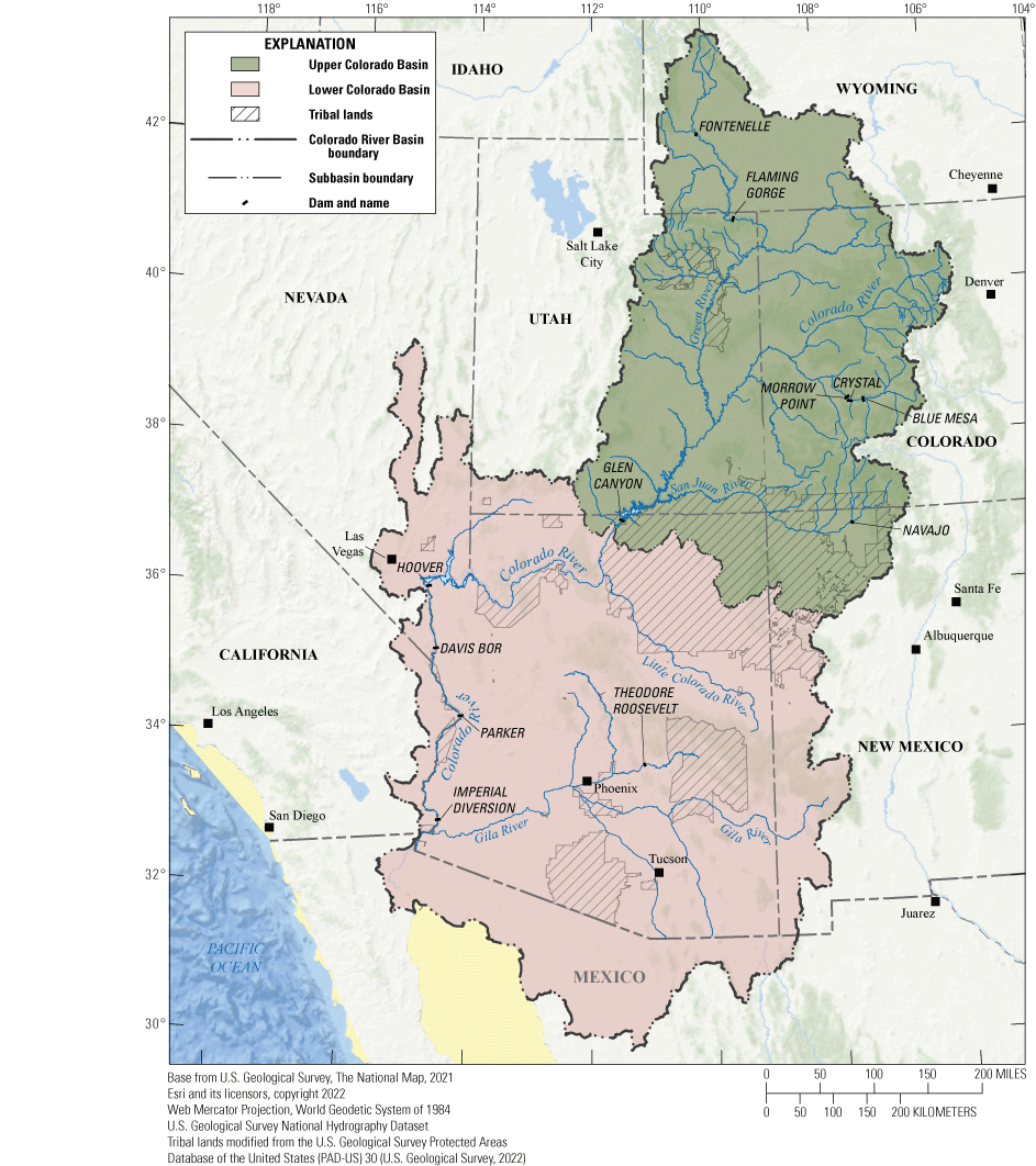
Map of the Colorado River Basin showing Tribal lands, subbasins, dams, and major tributaries.
The ASIST team—a multidisciplinary team of USGS regional science coordinators, scientists, and technology experts—is tasked to help the USGS increase the development of integrated, interdisciplinary science, data, models, and tools to address key science challenges related to large-scale drought effects within the Colorado River Basin. Information about the Colorado River Basin ASIST Initiative is available at https://www.usgs.gov/special-topics/colorado-river-basin/about-colorado-river-basin-asist-initiative. The ASIST team has gained invaluable experience performing science needs assessments and hosting and facilitating meetings and workshops to support interdisciplinary science and expand engagement and development of scientific collaborations between interested and affected parties and USGS scientists studying drought. During 2023, the ASIST team structured and facilitated a series of workshops to further the codevelopment of interdisciplinary drought science and technology project concepts for the Colorado River Basin. The ASIST team is in its third year of providing dedicated support for USGS scientists, science centers, programs, partners, and stakeholders (any person or entity with interests in a resource or location; Tillery, House, and others, 2022) seeking to expand and codevelop interdisciplinary science and technology projects related to drought in the Colorado River Basin. Previous activities have opened the door to collaboratively developing reliable and actionable scientific services and products for resource managers.
Report Purpose and Scope
The purpose of this report is to (1) inform workshop participants, USGS leadership and scientists, and agencies and organizations with responsibilities or interest in the Colorado River Basin of the outcomes from the 2023 Codesign Workshop Series; (2) describe the collaborative engagement process used to understand drought science needs and development of codeveloped science project ideas and concepts; (3) present the resulting codeveloped drought science project concepts; (4) highlight science data that may address identified drought science needs that will be included in the USGS Science Collaboration Portal for the Colorado River Basin (https://colorado-river-portal.usgs.gov/); and (5) describe lessons learned from the 2023 Codesign Workshop Series and the resulting best practices to improve the design of future workshops and team processes. The information in this report may help guide other regional or local interdisciplinary science teams to advance their collaborative science discussions and codevelopment of interdisciplinary science in the Colorado River Basin and other watersheds experiencing complex environmental challenges.
This report is organized into three sections. The first section describes an overview of the workshop process, workflow, and methods, including the preparatory use of stakeholder needs assessments to develop the workshop structure and participant list, the facilitation processes throughout the workshop, and methods used to synthesize the participant responses. The second section describes the synthesized workshop outcomes. The third section describes lessons learned and identifies potential next steps for developing the workshop outcomes into project proposals.
Workshop and Synthesis
This section (1) discusses the previous ASIST activities and workshops that played a crucial role in shaping the purpose and structure of the 2023 Codesign Workshop Series; (2) outlines the workshop objectives, core team structure, and selection process for participant roles; and (3) provides details about the workshop workflow, including daily and weekly schedules, activities, milestones, and accomplishments. This section also identifies the resources used during the workshops and summarizes and synthesizes the information gathered, which is discussed further in the subsequent sections.
Foundations for Codevelopment
One goal for the ASIST team is to ensure that the science developed through ASIST efforts meets the needs of stakeholders affected by long-term drought in the Colorado River Basin. The ASIST team iteratively builds on previous activities to better understand stakeholder science needs in the Colorado River Basin, the state of USGS science and the challenges and solutions associated with integrating drought science, and existing USGS capabilities and approaches to deliver drought science and data to a growing number of interested stakeholders and partners. Two of the foundational accomplishments, the Stakeholder Needs Assessment and the 2021 Science and Technology Collaboration Meetings (fig. 2), were especially important in structuring the 2023 Codesign Workshop Series. The Stakeholder Needs Assessment included the review of more than 200 recently published sources to characterize more than 400 stakeholder science needs and concerns of stakeholders related to drought (Frus and others, 2021). Information from the Stakeholder Needs Assessment was used to identify suitable stakeholders and their science needs that directly related to priority science topics as identified from the 12 science and technology series of meetings held in 2021. The 2021 Science and Technology Collaboration Meetings included a wide range of multidisciplinary USGS scientists and managers discussing complex, integrated science challenges and solutions related to drought in the Colorado River Basin. The 2021 Science and Technology Collaboration Meetings highlighted opportunities for ASIST to facilitate science integration in the Colorado River Basin by prioritizing specific research topics, connecting scientists across disciplines, and reducing barriers to stakeholder engagement and data access (Monroe and others, 2025). The Stakeholder Needs Assessment and the 2021 Science and Technology Collaboration Meetings were used to identify internal and external participants for the 2023 Codesign Workshop Series, develop core team drought themes and research topics, and explore the use of applying whiteboards, using polling, and planning and formatting virtual breakout and listening sessions.
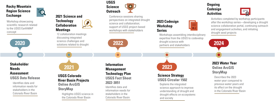
Timeline depicting previous Actionable and Strategic Integrated Science and Technology (ASIST) team engagement activities and publications from 2020 through 2024 that were used to inform the structure and objectives of the 2023 Codesign Workshop Series. The timeline shows incorporated outcomes (items below timeline) from previous engagement activities (items above timeline) and products. Lessons learned from the 2023 Codesign Workshop Series will be applied when the ASIST team organizes the second phase of activities, which includes the development of project proposals. USGS, U.S. Geological Survey.
Overview of Workshop Structure and Participants
The 2023 Codesign Workshop Series was designed to bring together interdisciplinary expertise associated with select stakeholders; USGS leadership, program managers, and scientists; and internal and external subject matter experts to identify drought science needs and drought and climate-based datasets and codevelop drought science project ideas and project concepts for the Colorado River Basin. Workshop objectives included the following: (1) discussing and understanding stakeholder drought science needs, (2) discussing and summarizing the state of drought science in the Colorado River Basin, (3) prioritizing drought science needs, (4) codeveloping project ideas and concepts, (5) identifying important drought and climate science data to be included in a new USGS collaborative science data portal for the Colorado River Basin, and (6) identifying lessons learned from the 2023 Codesign Workshop Series and creating a list of best practices to improve the design and structure of future codevelopment workshops and team processes.
The workshop was structured around three core teams focused on one of three drought-related topic questions previously identified from the 2021 Science and Technology Collaboration Meetings (Monroe and others, 2025).
-
1. Core team 1—Ecological drought: What are the most severe effects of hydrologic drought to Colorado River Basin ecosystems (river and upland areas)?
-
2. Core team 2—Drought mitigation intelligence: How can science inform planning and management when dealing with extreme drought conditions affecting the Colorado River Basin long term?
-
3. Core team 3—Cascading drought effects: How can science inform cascading and compounding hazards being experienced in the Colorado River Basin as secondary or tertiary effects resulting from the long-term drought conditions?
The 2023 Codesign Workshop Series included 67 participants from across the Nation (fig. 3) who were assigned to one of the three core teams. Two core teams were led by seven USGS scientists, and the third core team was led by eight USGS scientists, with the scientists representing multiple USGS science centers and offices. These scientists were either self-nominated or nominated by their science centers. Stakeholders and internal and external subject matter experts and internal USGS leadership and program managers were invited to participate in discussions and feedback sessions with core team members (table 1). Each core team included one or two ASIST facilitators to orient workshop participants and explain the objectives of agenda activities and the virtual formatting and tools that were expected to be used during discussions, breakout sessions, and core team work sessions. A list of potential stakeholders was identified from the Stakeholder Needs Assessment (Frus and others, 2021), the 2021 Science and Technology Collaboration Meetings (Monroe and others, 2025), the 2020 and 2022 USGS Rocky Mountain Region Science Exchanges (Tillery, Anderson, and others, 2022; Anderson and Tillery, 2022; Peterson and others, 2023), and through professional affiliations. The ASIST team emailed invitations to stakeholders with information about the purposes, goals, and dates of the workshop, why they were selected, and their anticipated participation and roles. Stakeholders were also invited to suggest colleagues. The ASIST team followed up with stakeholders who responded positively and contacted several suggested colleagues. The interested stakeholder participants (29) were then invited to a preworkshop orientation. External and USGS subject matter experts were identified by the expertise that was needed to discuss the state of the science for a broad range of science needed by partners and stakeholders. Stakeholders were assigned to core teams based on drought topic questions and their science needs associated with drought and general type of agency focus. Internal and external subject matter experts were assigned to core teams based on drought topic questions and their expertise. Two external information and technology experts were assigned to all core teams. The broad range of expertise and levels of experience of all workshop participants brought unique and diverse perspectives to each team. Given the challenging and complex issue of drought, these perspectives were critical to developing integrated science project ideas and concepts.
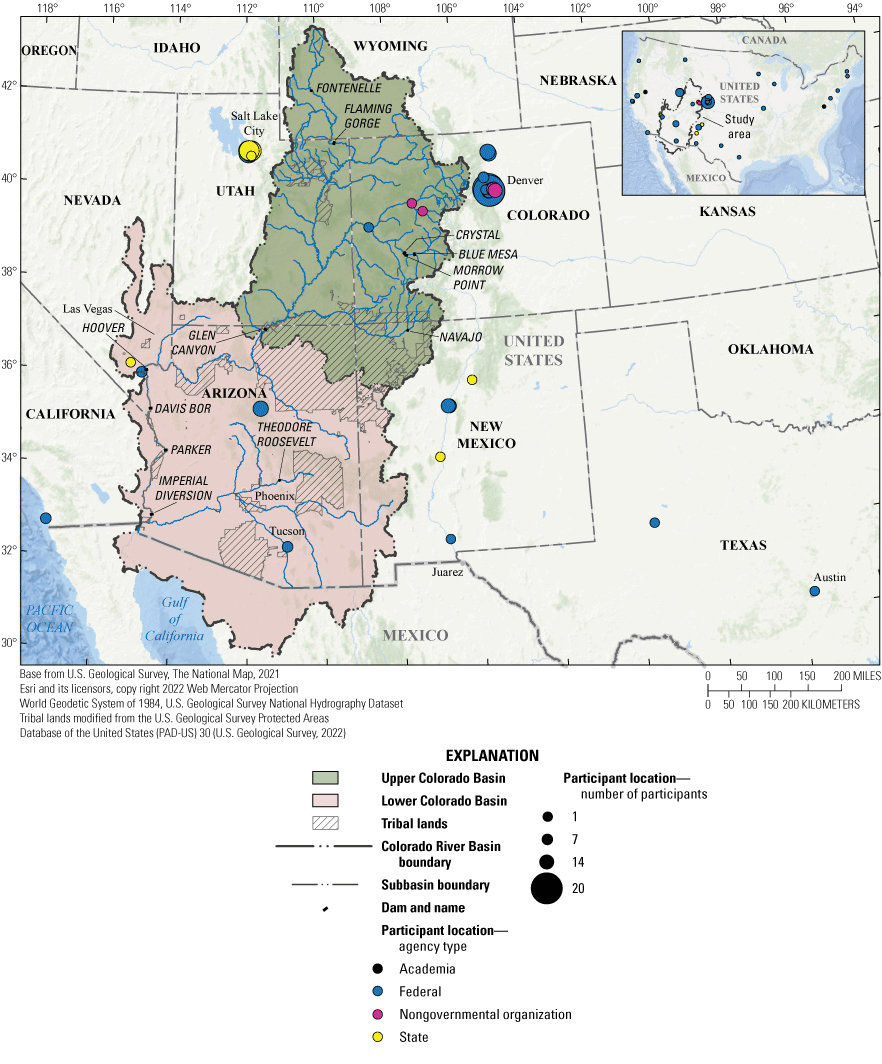
Map of the Colorado River Basin showing the locations, agency type, and number of participants who participated in the 2023 Codesign Workshop Series.
Table 1.
The 2023 Codesign Workshop Series participants grouped by their core team association and their participant role.[Numbers in parentheses indicate the number of participants with the same affiliation and position. ACIO, Associate Chief of Information Officer; AZWSC, Arizona Water Science Center; BLM, Bureau of Land Management; CAWSC, California Water Science Center; COWSC, Colorado Water Science Center; CRBFC, Colorado River Basin Forecasting Center; DOI, Department of the Interior; EPA, U.S. Environmental Protection Agency; FORT, Fort Collins Science Center; FWS, U.S. Fish and Wildlife Service; GECSC, Geosciences and Environmental Change Science Center; GGGSC, Geology, Geophysics, and Geochemistry Science Center; GMEGSC, Geology, Minerals, Energy, and Geophysics Science Center; IMPD, Integrated Modeling and Prediction Division; IWA, Integrated Water Availability; MD-DE-DC WSC, Maryland-Delaware-D.C. Water Science Center; NASA, National Aeronautics and Space Administration; NHMA, Natural Hazards Mission Area; NIC, National Innovation Center; NMWSC, New Mexico Water Science Center; NOAA, National Oceanic and Atmospheric Administration; NPS, National Park Service; NRCS, Natural Resources Conservation Service; NVWSC, Nevada Water Science Center; NWS, National Weather Service; Reclamation, Bureau of Reclamation; SBSC, Southwest Biological Science Center; SME, subject matter expert; SMEE-IMT, subject matter experts in information management technology external to USGS; SMEI-IMT, subject matter experts in information management technology internal to USGS; U.S., United States; Corps, U.S. Army Corp of Engineers; USDA, U.S. Department of Agriculture; USGS, U.S. Geological Survey; UTWSC, Utah Water Science Center; WGSC, Western Geographic Science Center; WMA, Water Mission Area; WYMTWSC, Wyoming-Montana Water Science Center]
The general workflow for the 2023 Codesign Workshop Series is depicted in figure 4. Group discussions with all workshop participants were typically followed by individual core team work sessions where core team members further deliberated on session outcomes and added daily and weekly session activity outcomes in their team portfolios. Collaborative sessions with stakeholders were generally followed by individual core team ideation, where they discussed, compiled, and synthesized feedback on science and data needs and science priorities previously discussed by stakeholders and subject matter experts. An iterative process followed as core teams worked on daily work session activities and then shared their progress back to all workshop participants at the end of the day and weekly accomplishments at the end of each week. Feedback from these daily and weekly updates provided opportunities for course corrections and revisions. In addition, core team members met with USGS program managers and internal and external subject matter experts to refine science project ideas and project concepts until the final workshop milestones were achieved at the end of the workshop series (fig. 5). Large group discussions at the end or beginning of the daily schedule fostered cross-team connections on project ideas and identification of common themes from stakeholders. This process ensured that specific, nonredundant project concepts were developed within each core team. Core teams also used their science portfolios to document weekly takeaways and weekly lessons that were used during weekly meetings to revise agendas, discussions, and recommendations for best practices at future ASIST workshops.
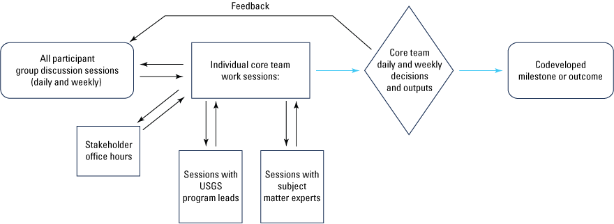
Workflow diagram of the 2023 Codesign Workshop Series daily and weekly sessions showing the process flow and iterations of engagement and feedback resulting in the codevelopment of workshop milestones. Oval rectangles reflect the starting and ending points of the process flow. Rectangle boxes reflect discussions and ideation. The diamond indicates where decisions were made and either shared back to workshop participants or progressed as a codeveloped milestone or outcome. Double black arrows represent discussion input and feedback. The black single arrow represents feedback on core team decisions and milestones. The blue arrows reflect the direction of process steps associated with decisions and the completion of milestones and other workshop outputs. USGS, U.S. Geological Survey.
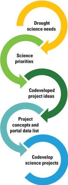
Diagram showing the milestones of the 2023 Codesign Workshop Series. Workshop participants first worked on learning more about stakeholder science needs. Science needs were then prioritized based on input by stakeholders, U.S. Geological Survey program managers, and internal and external subject matter experts. Codeveloped project ideas were then formulated to address prioritized science needs and expanded into project concepts. Available data were identified that could immediately be provided to address some stakeholder needs. Participants completed the first four milestones during the workshop series and will complete the conversion of project concepts into science project proposals as funding opportunities become available. Figure modified from a presentation figure that was used to help explain workshop flow and milestones during the workshop. Original figure developed by Jessica Driscoll (U.S. Geological Survey).
Table 2 provides a detailed list of the weekly schedule, daily workshop activities, and associated participant groups. The first week of the workshop series included activities that were designed to learn about the workshop structure and team participants, along with team-building activities for core team members. The primary focus during the first week was to (1) learn more about the invited stakeholders’ priority drought science and data needs, (2) identify existing science gaps and immediate science delivery needs, (3) learn more about USGS mission area science priorities and current activities and shared priorities between the USGS and stakeholders, and (4) formulate science project ideas and compile information in their team portfolios. Core team discussions between stakeholders occurred throughout the week through planned discussions and daily and weekly updates. Drought topic questions were provided to stakeholders prior to the workshops to facilitate and focus the discussion on their specific science needs and potential opportunities for future collaboration in drought science projects.
Table 2.
Overview of the 2023 Codesign Workshop Series weekly schedule, daily activities, and participant groups.[Roster of participants for each workshop day. All, all workshop participants; CT, core team; IP, USGS program managers internal participants; SME, subject matter experts; SMEE, subject matter experts external to USGS; SMEE-IMT, subject matter experts in information management technology external to USGS; SMEI, subject matter experts internal to USGS; SMEI-IMT, subject matter experts in information management technology internal to USGS; SP, stakeholder participants; USGS, U.S. Geological Survey]
Individual core team members continued discussions of stakeholder needs and science project ideas during the second week. Core teams refined science project ideas after meeting with internal and external subject matter experts and continued to evaluate existing science and technology capabilities. Core team members prioritized the identified science gaps and identified immediate actions to improve science delivery and communication. Individual core teams also focused on identifying targeted timeframes in which science gaps could be addressed. Ideation followed synthesis, and each core team grouped science project ideas by immediate, short-, mid-, and long-term actions. Each core team continued to organize all information associated with their discussions, work sessions, and synthesis activities into team portfolios. After additional iterations between stakeholders, USGS program managers, and internal and external subject matter specialists, science project ideas were prioritized by core team members. The prioritized list of science project ideas was presented to all participants for additional feedback at the end of the week. Core teams also used the prioritized list to begin drafting science project concepts.
At the end of week 2, core teams focused on synthesizing feedback and finalizing the list of project ideas. Activities during the third week of the workshop series included (1) completing science project concepts from the prioritized project ideas; (2) finalizing a list of completed science products for immediate inclusion in a USGS science collaboration portal; and (3) documenting weekly takeaways, lessons learned, and other information in science portfolios.
A list of core team weekly accomplishments is presented in table 3. The process used for project concept development during the workshop differs from the typical approach that begins with a predefined project scope in mind and seeks partners and funding to garner support. By first listening to stakeholders express their need for science to manage resources and make science-informed decisions for their organizations in the Colorado River Basin, the core teams focused on the delivery of data and information to stakeholders that would make an immediate difference in their management of natural resources.
Table 3.
List of 2023 Codesign Workshop Series core team weekly accomplishments.[Workshop participants were assigned to one of three core teams that were charged with understanding drought science needs and identifying project ideas and short-, mid-, and long-term science project concepts that can later be developed into funded science projects]
Workshop Resources and Information Gathered
The ASIST team used digital tools to share information with workshop participants and guide discussion activities. Each workshop took place virtually on a collaborative platform with full access to polling options, breakout rooms, and chat functionality. The ASIST team created a website that included group resources and individual pages for each core team. Workshop participants were provided daily and weekly agendas; links to team meetings and breakout rooms; biographical information about core team members, stakeholders, and subject matter experts; background materials; and recordings of presentations. Each core team had a separate web-based folder for team document sharing and organization. We used several information templates during the workshop to facilitate knowledge transfer across teams and during postworkshop synthesis activities. The templates included a document for daily notetaking organized by week, day, and session; a virtual whiteboard with virtual sticky notes for simultaneous viewing and editing by core team members to collaborate and share ideas during core team breakout sessions; and preformatted presentation slides and documents to share summaries of each team’s key concepts and takeaways throughout the workshop series. Key takeaways from each workshop session, including outcomes from group discussions and whiteboard exercises, were summarized at the end of each week and reported back to all workshop participants.
All materials and recordings developed during the workshop were archived for postworkshop reference and documentation purposes. Online polls were periodically administered to gauge the outlook of the core team members and facilitate discussion of the workshop framework and changes to the workshop agenda and activities as each week progressed. The polls provided an anonymous format for team members to submit candid responses. Team-building activities promoted trust amongst workshop participants and core teams and allowed open and inclusive core team brainstorming sessions. Some participating stakeholders held office hours outside of the scheduled workshop agenda for core team members to pose additional questions and get feedback on specific project ideas or data needs.
Workshop Outcomes
Each of the core team portfolios was reviewed and synthesized by the report authors to find common key takeaways for each week of the workshop series. Weekly core team accomplishments are summarized in table 3.
Key Takeaways from Week 1
Week 1 of the workshop series first focused core team members on team-building activities to identify their knowledge, experience, and skills. Presentations and discussions with stakeholders first centered on the codevelopment approach, and then core team members and subject matter experts listened to stakeholders discuss their drought-related science needs. Each core team then met with their assigned subject matter experts to further discuss stakeholder science needs, science gaps, and ideas to leverage existing science data or approaches. Discussion outcomes, thoughts, questions, and ideas were organized as science portfolios from which the initial project ideas were drafted for each team’s drought-related topic question. Core teams also identified common themes across all groups through their weekly cross-communication sharing activities.
Common Themes
Common themes that were brought up for discussion by participants included the need for monitoring networks with more representative sites and additional instruments and environmental sensors to expand the monitoring of stream and groundwater flows, consumptive water use, water quality, and air quality with better forecasting capabilities, along with the use of consistent methodologies throughout the Colorado River Basin. Participants also identified the need to evaluate current and historic monitoring networks and existing instrumentation to identify gaps and long-term record capabilities that would help maximize the benefit of new monitoring stations and instrument placement. Centralized, easily navigable, and transparent tools to access data and interpret science products were discussed, with emphasis on the need for new mechanisms for data and science dissemination and visualizations aligned with decision-making timelines. Stakeholders also stressed the need for more synthesis and interpretive products that provide information about the cascading effects of drought and climate across spatial scales (local, subbasin, and basin) and make comparisons of current ecohydrological conditions with past conditions (for example, predrought and long-term averages). It was determined that the cultural, economic, and sociological effects of drought could be more comprehensive with the addition of traditional ecological knowledge and adaptive management solutions. Long-term and continued engagement with stakeholders and Tribal community members that includes codevelopment of science projects, training, and science empowerment was also discussed as a need.
Foundational Challenges
Hydrological drought (characterized by a shortage of water in rivers, lakes, reservoirs, and groundwater caused by long-term meteorological drought) within the Colorado River Basin raises several challenges that were conveyed by workshop participants. As previously mentioned, the need for more monitoring across the Colorado River Basin was a recurring topic, with particular emphasis on areas affected by ecological degradation from mining or other land-use activities. The availability of long-term, stable funding for monitoring is an ongoing challenge that has led to gaps in data coverage and slow responsiveness to management-driven monitoring needs. This challenge is further exacerbated by the lack of information on the interconnectivity between terrestrial and aquatic processes in the Colorado River Basin system and how resource management decisions may create cascading effects throughout the system. Without sufficient monitoring in place, it is difficult to target restoration activities and evaluate their effectiveness.
Several stakeholders used specific place-based examples to convey monitoring and science needs in direct support of decision making. These examples included monitoring and remote sensing techniques to detect invasive species, interconnectivity of hydrologic and terrestrial systems, and real-time tracking of ecosystem responses to management actions in specific locations in the Colorado River Basin. Beyond the foundational data capture and dissemination, several stakeholders noted a key role of the USGS in delivering interpretive science. However, the dissemination of interpretive science products was identified as a major challenge because of inconsistent funding, publication requirements, and staffing. Similarly, differences between models used by the USGS and State and Federal land management agencies limit the direct applicability of USGS science in a management context. These differences in models also make it challenging to provide consistent information on system dynamics relative to long-term drought effects and future climate scenarios, draw reliable conclusions or make accurate forecasts, and determine ecological tipping points that are essential for developing effective management strategies.
Applying lessons learned from one scale to another, such as place-based studies to broader basin or regional assessments, is difficult to accomplish. Several stakeholders emphasized thinking beyond the Colorado River Basin boundaries, citing drought effects observed around the Great Salt Lake in Utah and the Salton Sea in California (dust generation), secondary ecological effects of desalinization activities (the process of removing salts and other minerals from water) in California, and co-occurring effects of fire throughout the western United States. These broader issues will continue to be a challenge to address without U.S. Department of the Interior-level initiatives to centralize data resources and promote integrated “big-data” assessments. At all scales, developing strong relationships between the USGS and stakeholders is essential. However, funding for building and sustaining these relationships is not widely available, further adding to the difficulties placed on individual scientists to maintain relationships while delivering high-quality and responsive science.
Key Takeaways from Week 2
Week 2 of the workshop series focused on reviewing, revising, and discussing week 1 portfolios and codeveloped project ideas, drafting new ideas to fill identified gaps, prioritizing project ideas, and transforming higher priority project ideas into project concepts. These activities were accomplished by continued feedback from stakeholders and the sharing of project ideas and discussions with subject matter experts. Subject matter experts provided their knowledge and perspectives based on new technology and innovative approaches and the state of the science for each of the three drought focal topics. Refer to the “Overview of Workshop Structure and Participants” section of this report for information on the three topics. Input and discussion topics on the state of the science included science studies, data, models, communication tools, and known expertise. Priority science needs were identified and sorted into immediate, short-term, mid-term, and long-term actions based on input by subject matter experts. The collective outcome from the week 2 activities included codeveloped project concepts with project timeframes, lists of ideas that span current multidisciplinary science topics, and lists of additional priority science gaps and needs.
Common Themes
Themes discussed by subject matter experts mirrored several highlighted by external stakeholders, namely the need for more integrated, interpretive science across temporal and spatial scales and improved and centralized data access and science resources. However, the issue of information overload for users was brought up as a key challenge associated with a centralized repository. Nonstationarity and persistence of hydroclimatic periods (for example, lengths of wet and dry periods) were also brought up as important challenges for future modeling and management projects. Discussions also emphasized the challenges associated with a “one-size-fits-all” approach, noting essential boots-on-the-ground and interpersonal community dynamics typical of local-scale studies. Communicating the relevance and importance of larger, regional-scale science is a challenge, and creative solutions to convey the broader context while being sensitive to local needs and concerns are essential.
State of the Science
The discussions on the state of the science between core team members and subject matter experts included relevant scientific studies, data, and models related to the three drought topical questions, new communication tools, and known expertise capacity. There was a strong consensus among subject matter experts and core team members that the USGS is doing broadly applied science relevant to numerous stakeholders across the Colorado River Basin and across USGS mission areas. Participants also identified numerous scientific studies occurring in the Colorado River Basin that are addressing drought and climate change. However, many of these studies or associated data are limited spatially and temporally, or in disciplinary scope, making it challenging to understand more complex drought processes or predrought conditions.
Workshop participants identified numerous projects being implemented at basin-sized scales (for example, the San Juan River Basin in Arizona, Colorado, New Mexico, and Colorado, and the Yampa River Basin in Colorado and Wyoming [refer to fig. 3]) and discussed long-term USGS monitoring activities related to streamflow. However, to effectively evaluate drought and climate change effects on water resources, water quality data and other interdisciplinary data are needed. Continuous water quality data are limited to what can be reliably measured with existing multiparameter sensors that have broader capabilities to measure cations, anions, and metals. Core team members and subject matter experts agreed that additional measurements could be applied at strategic locations across the Colorado River Basin. Existing records for climate, streamflow, and groundwater rely on multiple sites with short time series that may limit applications to spatially model drought cycles and predrought conditions. Like the strategic use of continuous sensors, more of these sites could be strategically established throughout the Colorado River Basin.
There are numerous models that can be used to quantify changes to water availability and use and how these changes may affect ecosystem function (aquatic and terrestrial). However, there remains a need to further integrate models across disciplines to fully appreciate subtle and complex changes that need to be understood by regulators and managers to inform decisions and support long-term planning. Workshop participants acknowledged that the scale of current modeled data output often reflects coarse outcomes with applications at larger landscapes and typically does not capture processes at local scales. However, participants also recognized recent advancements that apply predictive-based models to plan for drought occurrence and drought effects in the Colorado River Basin and elsewhere. Predictive models have improved from the incorporation of higher resolution meteorologic, hydrologic, and remotely sensed data. Other advancements are associated with machine learning models that are showing promise in predicting streamflow and groundwater drought onset with higher accuracy than existing National-scale, physically based models. Pairing artificial intelligence with machine learning has resulted in model outcomes that may be able to address more complex questions.
Workshop participants also identified numerous studies designed to better understand the cascading effects of drought. Although these studies address important knowledge gaps, participants noted that these studies typically reflect applied studies of a single discipline, reflect short temporal periods, or are very localized, which limits understanding of cascading effect processes occurring across the Colorado River Basin. For example, unlike USGS efforts to monitor water quality and quantity, monitoring of dust generation and transport is not standardized across the agency, and such studies struggle to obtain long-term funding support.
Science and Capability Gaps
Applying new technologies to long-term monitoring efforts can prove challenging. Equipment and implementation costs, lack of trained users of the technology, and poor interoperability with legacy data are a few examples of these challenges. However, despite challenges, team participants recommended the incorporation of new technologies that would have clear long-term benefits to better understand water quality condition changes resulting from drought. For example, they identified the expansion of real-time water quality constituent monitoring, including the use of new sensors capable of monitoring metals and emerging contaminants such as microplastics, as well as per- and polyfluorinated substances, which are known as forever chemicals (Bell and others, 2023).
Team participants also provided several examples of filling science and data gaps by strategically leveraging ongoing efforts. One example is the collection of water quality samples from additional research and monitoring sites that are strategically placed to detect early signs of environmental change. This kind of approach could also apply to determining how drought and land-use cover changes affect streamflow permanence (the degree to which rivers and streams maintain surface-flow conditions). Additional monitoring at key sites for water quality or streamflow sampling could fill spatial and temporal gaps. Team participants noted that when large basin studies integrate data across a region, process-level information needed to inform local land-use decisions is often lost. Team members suggested that more data connectivity across different basin scales could reveal collateral effects of drought, such as changes in water quality and fish populations.
Key Takeaways from Week 3
The emphasis of week 3 was on synthesizing stakeholder needs and subject matter expertise into project concepts. The week opened with each core team presenting their proposed projects to workshop participants for feedback and refinement. Project ideas were also presented to available stakeholders and subject matter experts. Teams were asked to reflect upon their project concepts relative to the other core teams and answer several questions, including identifying common themes, recommending methods to improve science delivery, and presenting recommendations for future actions at short, intermediate, and long timescales.
Common Themes
Common themes addressed through week 3 activities included areas of potential scientific study and methods for improving science delivery. All core teams thought it was important to identify and integrate existing data and projects relevant to drought in the Colorado River Basin, and to make those data more useful to stakeholders through visualizations, predictive modeling, and interactive decision-support tools. All teams also identified the benefits of scale-dependent, long-term monitoring networks, while also recognizing limited funding for those efforts. Other common themes included the need to consider nonstationarity in predictive and conceptual modeling, the benefits of considering water quality and water quantity holistically, and the need to investigate the effects of groundwater-surface water interactions on overall water availability.
Core teams identified two specific areas of scientific study. First, all teams identified the general need for consideration of socioeconomic effects or ecosystem services as important to future research efforts, while also noting that expertise in that area was minimal among the core team members. Second, the topic of dust was also identified as an important area of study, with a need for increased and long-term monitoring and research regarding effects on human populations and ecological systems, because long-term drought and aridification are expected to increase in the Colorado River Basin.
Immediate Actions and Recommendations
After final project refinements and discussions with stakeholders, subject matter experts, and other workshop participants, core teams were asked to identify actions to be taken in the near term to improve science delivery. Each of the core teams identified an immediate need to gather and organize existing Colorado River Basin data and science products in a centralized location available to the public. They agreed that a centralized data hub coupled with bibliographies of ongoing drought-related science in the Colorado River Basin would improve access and use of existing data and publications. Teams also indicated that steps should be taken to make new science products accessible to a wider audience, with emphasis on exploring alternatives to traditional reports and scientific journal articles. These alternatives could include fact sheets and geonarratives, which are web applications that combine interactive web maps with narrative text, images, and multimedia content. Teams also provided recommendations for actions to be taken at short, intermediate, and long timescales using an iterative and adaptive process. A common theme across different timescales and project concepts was that iterative and adaptive processes will produce the best science to meet management needs.
Teams suggested supporting informal networks of individuals and institutions by creating new and strengthening existing connections between USGS scientists, external scientists, and other stakeholders. These networks are likely to increase transparency and ensure equitable access to information, data, and ongoing scientific efforts. Teams emphasized the importance of cataloging past and ongoing relevant projects and science prior to embarking on new studies. They also recommended introducing coproduction principles into performance evaluations and other performance metrics to encourage accountability and participation.
A stand-alone recommendation was made to increase the accessibility and digestibility of USGS science products by using nontraditional formats such as interactive dashboards and maps, improving and focusing data visualizations for a wider audience, and providing data exploration opportunities without the need for large data downloads that may be technologically prohibitive. Additional recommendations included using information that was collected during earlier activities to identify knowledge gaps and enhancing monitoring networks and data collection to encompass underrepresented environments.
Long-Term Recommendations
Long-term recommendations focused primarily on administrative and foundational tasks that could support future coproduction efforts. Those recommendations included continued development of new relationships with diverse groups of stakeholders to support long-term monitoring efforts. Recommendations were also made for internal USGS actions that would enable and potentially enhance coproduction activities. For example, one team recommended creating an internal USGS boundary organization (similar to ASIST) that could facilitate interaction between USGS science and stakeholders. Another team suggested committing additional funding to after-project training and supporting knowledge transfer to improve science communication and end-user accessibility and use.
Summary of Science Delivery and Communication Needs
There was considerable overlap in the identified science needs and approaches to addressing these needs that were developed by the three core teams as the workshop progressed. Four main improvements needed for science delivery and communication were identified by the core teams: (1) development of a centralized, one-stop science portal; (2) development of timely, relevant, actionable science products; (3) guidance on application of data and science products; and (4) considerations for supporting findable, accessible, interoperable, and reusable principles (FAIR Principles).
-
1. Development of a centralized, one-stop science portal—From sessions with stakeholders during the workshop, core teams identified a need to bring together data from different sources into an integrated knowledge framework. The development of a data hub for USGS data and applicable models is one approach to addressing this need. The science hub would help align science delivery, including direct access to raw data from the USGS, with links to available data from stakeholders and other publicly available resources. The data hub could act as a virtual framework that allows multiple collaborators to work toward data synthesis, producing interpretive results. The data hub should also provide a platform for the integration and interpretation of multiple data sources to better address the science needs across a broad range of end users and communities, as well as access to plain language communication of science through fact sheets, geonarratives, and online tools. It should be noted that, although the sharing of data from across the Colorado River Basin can be improved through the integration of USGS data with data and models from Federal and non-Federal sources, housing non-USGS data on a USGS-hosted data hub may present U.S. Department of the Interior science integrity issues in the absence of rigorous internal review. Alternatively, providing a virtual library of links to external data and data products would enhance the data hub and uphold the science integrity policy. Hosting external data temporarily for integration working groups would also be an effective implementation of the data hub.
In parallel with the 2023 Codesign Workshop Series, the ASIST team completed a series of interviews and presentations with USGS science center directors and their geospatial data managers from across the western United States to understand existing USGS science and data delivery capabilities and mechanisms relevant to drought. Information from the interviews was then used to plan and host the Integrated Drought Science Summit during May 16–18, 2023, at the Esri auditorium in Redlands, California. The meeting was held in collaboration with data specialists and data visualization specialists from Esri as part of the USGS Esri enterprise agreement. Common themes identified from this effort included increased needs for data management, data visualization, and assistance to incorporate innovations in online platforms. The ASIST team incorporated these themes into planning and identified additional important data that could be included in an expanded USGS data portal. The results of the interviews were also used to codevelop a vision for the conceptualized USGS Science Collaboration Portal.
-
2. Development of timely, relevant, and actionable science products—Stakeholders need relevant, actionable, timely, interdisciplinary science information to inform adaptive resource management strategies in response to the effects of the multidecadal drought in the Colorado River Basin. Adoption of coproduction approaches (Selby and others, 2023) in collaboration with other agencies and nonprofit organizations can help identify common management-relevant questions and data needs that can support more interested parties in the Colorado River Basin. USGS scientists should consider stakeholder timelines for decision making when scoping projects that would produce data at relevant spatial and temporal scales. Different audiences approach science delivery tools with different expectations and levels of expertise in using technology. These differences need to be addressed in project communications and data delivery. Outreach to underserved communities, which often are the most severely affected by environmental problems and may have limited access to science information, should be prioritized. Increased engagement is particularly needed with Tribal Nations to collaboratively develop projects that are relevant to management needs. There is an ongoing ASIST Tribal engagement process that is intended to address this need. Information on the Tribal engagement series regarding drought in the Colorado River Basin is available at https://www.usgs.gov/special-topics/colorado-river-basin/news/tribal-engagement-series-drought-colorado-river-basin.
-
3. Guidance on application of data and science products—USGS partners and stakeholders require more technical guidance on the availability of data management tools and models. The coproduction process can be used to understand user preferences and patterns for digital information, data discovery, and delivery. ScienceBase (https://www.usgs.gov/tools/sciencebase), a platform that was established in 2016 as a mandatory repository for USGS data, contains a wide range of relevant data, but many stakeholders are not aware of its existence. Models and data management tools developed by USGS personnel are not broadly communicated and are challenging to discover. Having a region-specific catalog of data, models, and data management tools would help communicate the availability of USGS information. The OpenET portal (https://etdata.org/), which was developed by multiple organizations, including the USGS, provides easily accessible, satellite-based estimates of evapotranspiration for improved water management across the western United States. The OpenET portal has the potential to be a powerful tool for water management decisions in the Colorado River Basin.
-
4. Adherence to findable, accessible, interoperable, and reusable principles (FAIR Principles)—More user-friendly interfaces would be advantageous to partners, stakeholders, and the public. Science delivery and communications are largely developed for the larger scientific community (for example, USGS scientific investigation reports and peer-reviewed journal papers). Such products can contain very useful data and scientific interpretations; however, they are not widely accessible, and complex or nuanced content may not be well understood by policy makers, resource managers, and the public. The USGS also produces circulars (a synthesis of understanding about processes, geographic areas, issues, or USGS programs) and fact sheets, which are written in plain language and are intended to inform a broader community of decision makers and interested parties. Changing protocols for online data access have led to improvements in science delivery. For example, USGS water data downloads through the USGS National Water Information System (https://waterdata.usgs.gov/nwis?) were notoriously challenging for infrequent end users. In response, access to data has been migrated to the USGS National Water Dashboard (https://dashboard.waterdata.usgs.gov/app/nwd/?region=lower48), which has greatly simplified data access for both experienced and infrequent users.
Workshop Science Delivery
Core teams were asked to provide a summary of their discussions regarding limitations and challenges for science delivery improvements in the Colorado River Basin. The limitations and challenges identified consisted of the following: (1) interdisciplinary cooperation; (2) limitations on bandwidth, accessibility, and efficiency for large datasets; (3) need to adapt to dynamically emerging priorities; (4) compatibility and consistency of data; (5) maintenance and operation of online tools and resources; and (6) challenges to providing tools for forecasting and scenario testing.
-
1. Interdisciplinary cooperation—Interdisciplinary cooperation within the USGS is needed to further guide and set specific needs for study activities and goals. There is often a lack of communication between USGS programs about studies that may overlap in intent or approach. These studies may include local-scale data collection and interpretation that could benefit from collaborative analysis. Some immediate collaborative issues could be resolved with a database of USGS science programs and cooperators that are working within the Colorado River Basin. Differences in business models and budget access between different USGS mission areas can sometimes limit interdisciplinary work between USGS hydrologists, geologists, geographers, economists, biologists, ecologists, chemists, geophysicists, and other disciplines.
-
2. Limitations on bandwidth, accessibility, and efficiency for large datasets—The ability to update and deliver large datasets, including gridded time series and geospatial data, in a timely manner and in user-accessible formats is critical to inform management decisions for stakeholders and resource managers. A data hub can help make geographically linked ScienceBase data releases more discoverable. However, incorporating data from external sources into a USGS-hosted hub may be problematic. Collaborative data integration spaces, including ArcGIS Online (https://www.arcgis.com/index.html), facilitate data access by acting as central repositories and enabling seamless sharing between organizations. These spaces typically offer tools for data preparation, transformation, and integration and are designed to enable collaboration, allowing multiple organizations to work together on shared data.
-
3. Need to adapt to dynamically emerging priorities—The USGS must operate with the flexibility to adapt to emerging priorities that can be driven by natural disasters (for example, fires and floods), environmental effects directly caused by humans (for example, mine wastewater spills), or Congressional mandates. The sudden shift in priorities can limit the completion of studies and availability of data, and funding is not always available to follow up on emergency response work. The review process that ensures the quality of data and interpretive science can also affect the timeliness of science communication.
-
4. Compatibility and consistency of data—Data and interpretive results from varied sources often have different spatiotemporal scales, methodologies, and formats that present challenges for end users. Tools are needed for more efficient, intuitive access. Earlier ScienceBase data releases are not universally compatible for georeferencing the information, and data in pre-ScienceBase (published prior to 2016) reports that are needed to understand drought effects are not easily discoverable. There is a lack of consensus on the terminology to use for drought studies, including the definition of aridification and what constitutes a drought by ecological, hydrological, and social metrics. Consumptive water-use data that are available from State and Federal agencies are challenging to interpret across the region. Information on diversions, including reservoirs and canals, is challenging to access and is not consistent across the Colorado River Basin. Mismatch of units, time steps, and other metadata between sources can limit data use in models. Supporting information, including historic photographs or land-use information, is lost in older reports.
-
5. Maintenance and operation of online tools and resources—Available long-term funding for data collection, database management, quality assurance and quality control, and distribution is needed. Monthly costs associated with housing large datasets in the cloud (cloud object storage), along with usage costs for applications that incorporate the architecture of data lakes (large raw data datasets) and data warehouses to pursue durable approaches to data management, may be substantial.
-
6. Challenges to providing tools for forecasting and scenario testing—The lack of strategically placed monitoring locations can constrain hydrologic forecasts. More comprehensive data and improved data integration with newer modeling approaches are needed to improve streamflow and groundwater drought forecasting. Knowledge of dynamic vegetation composition and cover is needed for a variety of drought models. These data are available through commercial websites, but awareness of portals for satellite imagery is limited within individual working groups. Better communication of available geospatial tools needs to be facilitated. Improvements are needed in the application of machine learning tools to keep models and forecasts updated. The USGS needs durability and access to emerging data management tools to respond to the dynamic need of providing science to support management needs in a changing climate regime.
Proposed Projects
Project ideas were developed by the core teams after listening sessions with stakeholders and input from USGS subject matter experts. The core teams were organized around topical questions associated with hydrologic drought effects, science to inform planning and management, and understanding the cascading effects of drought in the Colorado River Basin. Project ideas developed by the three core groups intersected all topical-related issues such as dust, fire, and water supply at multiple spatial scales (local to regional) and temporal scales (immediate, short-, mid-, and long-term). Nine project concepts were proposed by the core groups, each designed to address stakeholder needs communicated through facilitated discussions (table 4).
Table 4.
Summary descriptions of codeveloped science project concepts (short-, mid-, and long-term science project concepts that can later be developed into funded science projects), products, and potential codevelopment stakeholders.Understanding Shifting Ecohydrological Baselines
Ecohydrology is the study of the interactions between water and ecological systems. An ecohydrological shift refers to a significant change in the interactions between ecological systems (such as vegetation and wildlife) and hydrological processes (such as water availability, movement, and quality) within a given landscape. The objective of this project is to better understand what ecohydrological baselines are affected by prolonged drought and how information and data can be used to identify patterns of shifts across the Colorado River Basin. For example, a spatiotemporal hydrologic framework could be developed using snowpack and streamflow data combined with regional-scale precipitation models to evaluate current and potential future effects of drought on ecosystem health. Remote sensing data, including vegetation indices and soil moisture, could be used to evaluate shifting vegetation patterns. The proposed project could then use data collected for decades to create a model for projected drought effects and identify priority habitats that are vulnerable. Understanding ecohydrological shifts allows land management agencies to make informed decisions regarding land-use planning and resource management and can help agencies implement adaptive management strategies that are responsive to ongoing environmental changes. This project addresses stakeholder needs for more effective public-facing access to data and information delivery. Stakeholders could include the agencies that need more predictive information on ecosystem change, including the Bureau of Reclamation, Bureau of Land Management, National Park Service, and U.S. Fish and Wildlife Service. Stakeholders from the U.S. Environmental Protection Agency, the consulting firm Stantec (Denver, Colorado), the nonprofit organization Sageland Collaborative (Salt Lake City, Utah), and the philanthropic organization Walton Family Foundation (Bentonville, Arkansas) demonstrated an interest in identifying and communicating the effects of regional drought.
San Juan River Basin Synthesis
The objective of the San Juan River Basin synthesis project is to determine how ongoing drought has affected the cumulative effects of land management practices on water availability, water quality, and fisheries integrity. A nested subbasin approach would be used to address regional patterns at the basin scale, with specific processes (for example, metal input from natural background and mining activity) investigated in lower order subbasins. Existing USGS datasets, including streamflow, water quality, land-use coverage, and chemistry data from Lake Powell sediment cores, would be integrated with ecosystem data from the U.S. Fish and Wildlife Service to evaluate how the drought cycle has affected streamflow, trace-metal source areas, and sedimentation that affect the San Juan River Basin. Partners for this project may include the Navajo Nation, Arizona, New Mexico, and Utah; the Jicarilla Apache Nation, New Mexico; the Ute Mountain Ute Tribe; the Southern Ute Indian Tribe of the Southern Ute Indian Reservation, Colorado; the U.S. Fish and Wildlife Service; the Bureau of Reclamation; the U.S. Environmental Protection Agency; the nonprofit organization Trout Unlimited (Durango, Colorado); and State environmental agencies in Colorado, New Mexico, and Utah.
Incorporating Dynamic Land Cover into Hydrologic Models
Changes in vegetation coverage after megafires may have a profound effect on hydrologic cycling. Few hydrologic models incorporate dynamic land cover data into snow-to-flow modeling. Researchers recognize that long-term drought and aridification drive changes in land use and land cover with cascading effects on flow forecasts. Dynamic land-surface coverage, including land-use and vegetation patterns, hydrology, and landscape ecology, across multiple spatial and temporal scales can be integrated with efforts, including the proposed “Understanding Shifting Ecohydrologic Baselines” project, to provide a holistic approach to watershed modeling. The resulting information would provide water managers and policy makers with more accurate short- and long-term streamflow forecasts while reflecting changes in vegetation cover.
Aridification Compared to Drought
The objective of this project is to determine if the reduction in precipitation (and the resulting hydrological and ecological changes) in the Colorado River Basin is a temporally discrete drought or has progressed to aridification with resultant irreversible ecological changes. The first steps of this project include adopting a universally accepted definition of aridification based on interdisciplinary studies that have already developed metrics that can be evaluated using USGS data. This project can occur over multiple spatial scales to determine whether aridification is apparent across the Colorado River Basin or is spatially discrete. Hydrological and snowpack datasets can be combined with hydrologic modeling to look at the long-term trends of water supply. Including an ecological perspective using long-term monitoring of piñon-juniper woodland, sagebrush steppe, grassland, and montane ecosystems would provide metrics on soil moisture and vegetation loss that would integrate well with hydrologic monitoring. An outcome of this project would be to define the effects of drought and (or) aridification as a potential driver of environmental change in the Colorado River Basin. Partners for this project could include the Bureau of Reclamation, Bureau of Land Management, National Park Service, and Utah Department of Natural Resources.
Surface Water-Groundwater Interactions
This project concept is focused on improving the understanding of surface water and groundwater interactions and their effect on streamflow generated from snowmelt. The exchange between hydrologic compartments can help inform water management, including reservoir releases and conservation measures intended to support riparian sustainability and streambank water storage. A multiyear evaluation of the interaction between snowmelt, surface water, and groundwater would determine how the hydrologic cycle varies between wet and dry years. The project focus would be on the stream-reach scale with specific locations determined by potential partners, including the National Park Service, Bureau of Reclamation, New Mexico Bureau of Geology and Mineral Resources, and nonprofit organizations Aspen Global Change Institute (Basalt, Colorado) and Sageland Collaborative (Salt Lake City, Utah). The project as conceived would require new chemical tracers at the stream-reach scale. Chemical tracers can provide quantitative or qualitative estimates of recharge and identify sources of recharge, velocities, and travel times of water movement. Existing data from USGS studies could be synthesized to identify data gaps in the Colorado River Basin that require tracer studies and create a regional perspective across daily, annual, or decadal timescales for identifying critical stream reaches.
Cascading Effects of Drought on Dust
Decades of USGS studies in the Colorado River Basin have demonstrated that soil destabilization through land management practices and drought has resulted in the production of dust with deleterious effects on human and ecosystem health. Monitoring by the USGS and agency partners has quantified dust effects in the vicinity of uranium mining near Grand Canyon National Park, landscape-scale dust generation from recreational and energy extraction activities in the Colorado Plateau in Utah, and the effect of dust on the acceleration of snowmelt in the Rocky Mountains. There is an immediate need for data organization and improved data access that caters to data discovery relative to common dust questions and stakeholder needs. Development of an integrated, continuous dust monitoring network would help inform land management practices for States, the Bureau of Land Management, the National Park Service, and the Natural Resources Conservation Service.
Cascading Effects of Drought on Water Availability
Decreases in water availability can have substantial effects on hydroelectric power generation, ecosystem health, and socioeconomic aspects of human societies. However, there are substantive gaps in understanding the effects of decreased surface-water availability on groundwater resources. Some of these gaps are associated with representative monitoring sites that are insufficiently distributed spatially and vertically across groundwater gradients. Understanding surface water and groundwater interactions in the Colorado River Basin is increasingly important. A better understanding of the cascading effects of drought and (or) aridification on water availability and the cascading effects of reduced water availability would provide helpful information for planning adaptation measures to address long-term severe drought.
Cascading Effects of Drought on Socioeconomic Factors
The socioeconomic factors associated with long-term drought in the Colorado River Basin are complex and interconnected. Addressing these challenges requires a comprehensive approach that considers water management, agricultural practices, economic stability, and community resilience. Decreases in water availability can have substantial effects on hydroelectric power generation, ecosystem health, and socioeconomic aspects of human societies. Additionally, there are substantive gaps in understanding the effects of decreased surface-water availability on groundwater resources and their socioeconomic importance to maintaining agriculture in the Colorado River Basin. Drought conditions can significantly reduce crop yields and affect livestock health, leading to economic losses for farmers and ranchers. In addition, agricultural producers may face higher costs for irrigation, feed, and water purchases, which can strain their financial viability and lead to increased food prices. Job losses in agriculture can cascade to farm-related industries and local economies. Drought can reduce water levels in lakes and rivers, affecting recreational activities such as boating, fishing, and tourism, which are vital to local economies.
Socioeconomic analyses related to water quantity and availability and drought impacts (including increased irrigation costs, reduced crop yields, and loss of farm income) in the Colorado River Basin would help address many known gaps. Socioeconomic studies could also be used to find additional solutions to increased competition among water users. These studies could also be used to determine how water transmission transfers that are below costs can be a burden to others inside and outside of the Colorado River Basin. Ultimately, a socioeconomic approach developed by the USGS, the Bureau of Reclamation, and State partners could help guide prioritization of water-resource allocation between domestic, industrial, agricultural, and commercial uses and potentially reduce conflicts between States, agricultural users, and urban areas.
Ongoing and Upcoming Activities
This section discusses ongoing and upcoming activities related to (1) developing a collaborative data portal for the Colorado River Basin; (2) creating best practices for organizing collaborative workshops, engaging internal and external participants, and codeveloping science ideas and science projects; and (3) initiating other activities to develop project proposals and future outreach and engagement with workshop participants and new stakeholders.
Integrating Science through a Collaboration Portal
The development of a centralized science portal for the Colorado River Basin to disseminate data, form science connections, create communities, and act as a forum for science collaboration was a known stakeholder need recognized by science centers during the science delivery interviews. The USGS Science Collaboration Portal for the Colorado River Basin was created as a stakeholder engagement platform where two-way communication is the foundation, rather than a one-way communication model that is typical of standard web pages. The contribution from the 2023 Codesign Workshop Series consisted of specific case examples for science and data that could be delivered through the portal (table 5). This information was used to identify the initial content and functionality for the centralized portal and highlighted the need to develop an online format that facilitated interactivity through a community-based structure. The portal is a resource to:
-
• Optimize use and discoverability of USGS science in the Colorado River Basin;
-
• Support decision making for partners and stakeholders;
-
• Communicate the success, value, and effect of science;
-
• Provide information needs ranging from spatially broad and common needs to local or specific needs for users; and
-
• Contribute to data visualization and storytelling.
Table 5.
Examples of available online resources, data, and science information that have been added to the U.S. Geological Survey (USGS) Science Collaboration Portal based on suggestions by the 2023 Codesign Workshop Series participants—these examples are organized by five interdisciplinary subjects (atmosphere and climate, ecology, fire, land use land cover, and water resources) to illustrate the organization of data in the portal.[APRSWXNET/CWOP, Automatic Position Reporting System as a WX NETwork/Citizen Weather Observation Program; ASIST, Actionable and Strategic Integrated Science and Technology; CONUS, conterminous United States; NWS, National Weather Service; PRISM, Parameter-elevation Regressions on Independent Slopes Model; RAWS, Remote Automated Weather Stations; SNOTEL, SNOw TELemetry]
| Title or identifier | Brief description | Website | Data type |
|---|---|---|---|
| PRISM | Climate visualizations and gridded climate data for CONUS | https://prism.oregonstate.edu/ | Online gridded data (CONUS) |
| PurpleAir | Point (sensor) data for air quality | https://community.purpleair.com/t/purpleair-data-download-tool/3787 | Map tool and online data |
| MesoWest | Interactive map for viewing and retrieving stations’ climate (RAWS, NWS, SNOTEL, APRSWXNET/CWOP) | https://mesowest.utah.edu/ | Interactive map tool and online data |
| NatureServe ArcGIS Online | Map viewer for imperiled vascular plants and species richness | https://geohub-natureserve.opendata.arcgis.com/ | Single map image, limited download (raster data, .png, .jpeg, .tiff) |
| Sagebrush Ecosystem Data Viewer | Data viewer for spatial datasets developed by the USGS and partners | https://doi.sciencebase.gov/sedv/ | Viewable data layers and associated metadata, and links to data for download |
| National Phenology Network | Data for a suite of historical, real-time, and forecasted phenology map products | https://www.usanpn.org/data | Online map viewer, customized online data |
| Wildfire hazard potential | Wildfire hazard potential for the conterminous United States aggregated from States to block groups and 50-kilometer hex bins | https://colorado-river-portal.usgs.gov/maps/7b67417ceb5249cbb5fc904469d5d716/explore?location=45.270219%2C-121.235533%2C7.08 | Web map visualization, vector data accessed with Esri logon |
| Burn severity viewer | Interactive map portal to online data from various sources | https://burnseverity.cr.usgs.gov/viewer/ | Geospatial data for burn perimeter, burn intensity |
| Burned Area Emergency Response (BAER) burn severity data | Publicly available data for individual fires, including prefire and postfire imagery | https://burnseverity.cr.usgs.gov/baer/baer-imagery-support-data-download | Portal to online geospatial data (vector and raster formats) |
| Moderate Resolution Imaging Spectroradiometer (MODIS) vegetative indices Normalized Difference Vegetation Index (NDVI) and Enhanced Vegetation Index (EVI) | Data used to monitor global vegetation conditions and land cover changes at 16-day intervals at 250 meters | https://earthexplorer.usgs.gov/ | Online geospatial data, .tiff raster files with 250-meter grid resolution |
| National Land Cover Database (NLCD) | National land cover information at the national scale for a wide variety of environmental, land management, and modeling applications | https://www.sciencebase.gov/catalog/item/655ceb8ad34ee4b6e05cc51a | Gridded 30-meter data for CONUS |
| GAP-LANDFIRE National Terrestrial Ecosystems dataset | Dataset that includes detailed vegetation and land cover patterns for the continental United States | https://www.usgs.gov/programs/gap-analysis-project/science/land-cover-data-download | Gridded geospatial data (.tiff format) for CONUS |
| National Resources Conservation Service data | Interactive map tool providing graphs, visualizations, and access to data: snow, precipitation, soil moisture, streamflow, and reservoirs | https://nwcc-apps.sc.egov.usda.gov/imap/ | Map tool, graphics, and online data (.csv format) |
| USGS National Water Dashboard | Interactive map tool providing access to water data: streamflow, groundwater, water quality, and precipitation | https://dashboard.waterdata.usgs.gov/app/nwd/en/ | Map tool, graphics, and online data (.csv format) |
| USGS National Map Viewer | Interactive map tool providing access to geospatial data: elevation, imagery, and hydrography | https://apps.nationalmap.gov/viewer/ | Various online datasets for the United States (raster and vector formats) |
A key feature of the portal includes the ability to post comments, have discussions about data, and join both private and public communities. Other features of the portal include the ability to search and access a curated list of spatial data layers, view the data layers on an interactive map, explore a set of communities with specific themes, and explore other projects and featured stories from within the Colorado River Basin. The evolution of the portal will be driven by continued stakeholder engagement and feedback on site content, structure, and functionality.
Best Practices for Workshop Engagement and Codevelopment
A postworkshop survey was distributed to all USGS core team participants and facilitators to gather feedback on the workshop experience and opportunities to improve future workshops. In large part, the participants who responded to the postworkshop survey reported that the workshops were a valuable use of their time and efforts, their team appreciated and respected team members, and they were able to build robust scientific concepts by incorporating the diverse skillsets and perspectives represented by their core team and stakeholders. Interactions with stakeholders through both formal workshop sessions and more informal office hours were also described as being helpful. Core team members described the length of the workshop as being reasonable, with sufficient time to complete documentation of workshop materials and templates and to collaborate effectively. However, they indicated that they could have used additional time for the following activities: (1) processing and synthesizing information from stakeholders and subject matter experts; (2) brainstorming, prioritizing, and refining project concepts; and (3) working across core teams when project ideas and concepts overlapped. Suggestions for workshop engagement and codevelopment best practices were as follows:
-
• Ensure that the virtual meeting format is effective and facilitates greater diversity in location, expertise, responsibilities, and priorities—virtual meetings provide a uniformity of experience and participation compared to hybrid meetings.
-
• Use seed questions to improve the flow of conversation, and use the format of breakout sessions to encourage open discussion, impromptu questions, and spontaneous sharing of ideas.
-
• Be flexible to adjust the agenda content and length to encourage group feedback.
-
• Allow teams to self-regulate for breaks during brainstorming sessions based on their group dynamic, momentum, and participant needs.
-
• Use facilitators and notetakers in breakout groups to perform vital roles of keeping teams on track and documenting group collaborations and outcomes.
-
• Repeat information on session-specific tasks, key outcomes, and common interests of workshop participants—starting and ending each day with a summary of major outcomes from the day and a plan for the next day is important for emphasizing conclusions and additional work to be done.
-
• Get daily feedback from participants to address questions, prompt key discussions, or swiftly resolve issues.
-
• Foster personal comfort and connections by using small groups and sharing with the larger groups.
Outreach and Engagement
Future outreach and engagement with workshop participants and a broader range of stakeholders is needed to continue efforts on the Science Collaboration Portal, with emphasis on feedback and testing of site content, structure, and functionality, along with identification of additional data needs. Additional outreach and engagement with USGS scientists and interested stakeholders are also needed to advance project concepts into science actions. Each of the nine project concepts directly identified short-term goals or objectives to advance science or generate products beneficial to stakeholders. Short-term deliverables identified for each project concept included literature reviews and syntheses that would be structurally formatted to address pressing drought information and serve as a knowledge base to develop concepts into one or more project proposals. Other examples of short-term deliverables included data releases, models that can run newly incorporated data, and fact sheets or other information that can help inform stakeholders of existing information. Future outreach and engagement will be used to develop detailed steps for short-term objectives and deliverables and to develop project proposals. Each project concept may be associated with one or more project proposals to address immediate, short-, and long-term science objectives.
The ASIST team also plans to engage USGS scientists to determine if existing research can fill identified science gaps or be leveraged to strengthen observations across space and time directly. Leveraging existing capabilities often leads to improved efficiencies and quicker results. Expansion of current science efforts might require additional outreach and engagement with existing stakeholders who are already involved with or supporting ongoing science studies. Engagement with new stakeholders might be needed if current science efforts were to expand to locations other than the Colorado River Basin. Other ASIST team outreach and engagement activities to advance project concept proposals could include the following:
-
• Aligning concept proposals and study objectives with USGS mission areas and regional priorities
-
• Determining stakeholder interest in developing or supporting project proposals and science planning and coproducing and implementing drought-based studies
-
• Developing listening sessions with interested parties from individual Tribes that would like to collaborate with the USGS on drought characterization and adaptation in the Colorado River Basin—part of this engagement could be used to share information and project concepts of the portal
-
• Continuing outreach through presentations at science conferences, collaborative workshops, and meetings with stakeholders through 2026
Conclusion
The U.S. Geological Survey (USGS) is actively addressing the multidecadal drought in the Colorado River Basin through a collaborative, interdisciplinary approach aimed at developing the necessary science, data, and tools to support and optimize the management of water resources and land use by resource management agencies. The Actionable and Strategic Integrated Science and Technology team hosted three collaborative workshops (February 27–March 3, 2023; March 27–March 31, 2023; and April 24–April 28, 2023) to convene interdisciplinary expertise from stakeholders (any person or entity with interests in a resource or location), USGS leadership, program managers, scientists, and internal and external subject matter experts. The goal was to identify drought science needs, explore drought and climate-based datasets, and codevelop project ideas and concepts related to drought science for the Colorado River Basin.
The purpose of this report is to inform workshop participants, USGS scientists and leadership, and agencies and organizations with responsibilities or interests in the Colorado River Basin about the outcomes of the 2023 Codesign Workshop Series. This report describes the collaborative engagement process used to understand drought science needs and presents the resulting codeveloped drought science project concepts. Additionally, this report highlights select existing scientific data that may help address identified drought science needs, which will be included in the USGS Science Collaboration Portal. This report also shares lessons learned from the 2023 Codesign Workshop Series and outlines best practices to enhance the design of future codevelopment workshops and team processes.
The information and insight that was collaboratively gathered from participants during the 2023 Codesign Workshop Series achieved the objectives of identifying needed improvements to science delivery, communication, and initiating the development process between the core team and stakeholder participants. At the end of the workshop, project concepts were conveyed to participants for feedback. After the workshop, project concepts were communicated to USGS scientists and leadership, existing partners, and the larger community of stakeholders in the Colorado River Basin through conference presentations, summary products, and collaborative discussions. Outcomes from the workshop have guided next steps, including the design and development of the USGS Science Collaboration Portal, Tribal engagements, research proposal development, and the prioritization and funding of selected seed projects. As additional funding becomes available, select projects that are in alignment with funding, administrative, and stakeholder priorities are anticipated to move forward through collaboration and coproduction with partners to accomplish the short-term goals identified for the projects.
References Cited
Anderson, E.D., Erxleben, J.R., Qi, S.L., Monroe, A.P., and Dahm, K.G., 2022, U.S. Geological Survey Colorado River Basin Actionable and Strategic Integrated Science and Technology (ASIST)—Information Management Technology Plan: U.S. Geological Survey Fact Sheet 2022–3051, 4 p., accessed January 12, 2024, at https://doi.org/10.3133/fs20223051.
Anderson, P.J., and Tillery, A.C., 2022, Presented abstracts from the U.S. Geological Survey 2020 Rocky Mountain Region Science Exchange (September 15–17, 2020): U.S. Geological Survey Open-File Report 2022–1040, 23 p., accessed January 12, 2024, at https://doi.org/10.3133/ofr20221040.
Beier, P., Hansen, L.J., Helbrecht, L., and Behar, D., 2016, A how-to guide for coproduction of actionable science: Conservation Letters, v. 10, no. 3, p. 288–296, accessed January 12, 2024, at https://doi.org/10.1111/conl.12300.
Bell, M., Gray, E, and Beisner, K.R., 2023, Assessment of per- and polyfluoroalkyl substances in water resources of New Mexico: U.S. Geological Survey web page, accessed January 16, 2024, at https://www.usgs.gov/index.php/centers/new-mexico-water-science-center/science/assessment-and-polyfluoroalkyl-substances-water#overview.
Brown, S., 2021, Machine learning, explained: Massachusetts Institute of Technology Sloan School of Management web page, accessed January 16, 2024, at https://mitsloan.mit.edu/ideas-made-to-matter/machine-learning-explained?utm_source=mitsloangooglep&utm_medium=social&utm_campaign=machinelearnexp&gad _source=1&gclid=EAIaIQobChMIi9Dc59PigwMVhxStBh0DSAoCEAMYASAAEgI1CvD_BwE.
Cambridge Dictionary, 2024a, Co-development: Cambridge Dictionary web page, accessed January 12, 2024, at https://dictionary.cambridge.org/us/dictionary/english/co-development.
Cambridge Dictionary, 2024b, Dynamic: Cambridge Dictionary web page, accessed January 12, 2024, at https://dictionary.cambridge.org/us/dictionary/english/dynamic.
Cambridge Dictionary, 2024c, Ideation: Cambridge Dictionary web page, accessed January 12, 2024, at https://dictionary.cambridge.org/us/dictionary/english/ideation?q=Ideation.
Choi, B.C.K., and Pak, A.W.P., 2006, Multidisciplinarity, interdisciplinarity and transdisciplinarity in health research, services, education and policy—1. Definitions, objectives, and evidence of effectiveness: Clinical and Investigative Medicine, vol. 29, no. 6, p. 351–364, accessed January 12, 2024, at https://pubmed.ncbi.nlm.nih.gov/17330451/.
Dahm, K.G., Hawbaker, T., Frus, R.J., Monroe, A.P., Bradford, J.B., Andrews, W.J., Torregrosa, A., Anderson, E.D., Dean, D., and Qi, S.L., 2023, Colorado River Basin Actionable and Strategic Integrated Science and Technology Project—Science strategy: U.S. Geological Survey Circular 1502, 57 p., accessed January 12, 2024, at https://doi.org/10.3133/cir1502.
Flinterman, J.F., Teclermariam-Mesbah, R., Broerse, J.E.W., and Bunders, J.F.G., 2001, Transdisciplinary—The new challenge for biomedical research: Bulletin of Science, Technology & Society, v. 21, no. 4, p. 253–266, accessed January 16, 2024, at https://doi.org/10.1177/027046760102100403.
Frus, R.J., Hawbaker, T.J., Anderson, E.D., Anderson, P.J., Andrews, W.J., Bradford, J.B., Dean, D.J., Duniway, M.C., Horton, R.J., Jones, D.K., Monroe, A.P., Qi, S.L., Skinner, C., Thomas, K.A., Tillery, A.C., Torregrosa, A., and Dahm, K.G., 2021, A snapshot of stakeholder science needs related to drought in the Colorado River Basin: U.S. Geological Survey data release, accessed January 16, 2024, at https://doi.org/10.5066/P9CTXP26.
Jenni, K.E., Goldhaber, M.B., Betancourt, J.L., Baron, J.S., Bristol, R.S., Cantrill, M., Exter, P.E., Focazio, M.J., Haines, J.W., Hay, L.E., Hsu, L., Labson, V.F., Lafferty, K.D., Ludwig, K.A., Milly, P.C., Morelli, T.L., Morman, S.A., Nassar, N.T., Newman, T.R., Ostroff, A.C., Read, J.S., Reed, S.C., Shapiro, C.D., Smith, R.A., Sanford, W.E., Sohl, T.L., Stets, E.G., Terando, A.J., Tillitt, D.E., Tischler, M.A., Toccalino, P.L., Wald, D.J., Waldrop, M.P., Wein, A., Weltzin, J.F., and Zimmerman, C.E., 2017, Grand challenges for integrated USGS science—A workshop report: U.S. Geological Survey Open-File Report 2017–1076, 94 p., accessed January 16, 2024, at https://doi.org/10.3133/ofr20171076.
Mackay, D.S., 2019, Ecohydrology—What’s in a name?: Eos web page, accessed January 12, 2024, at https://doi.org/10.1029/2019EO123093.
Monroe, A.P., Alexander, J.S., Anderson, E.D., Anderson, P.J., Andrews, W.J., Driscoll, J.M., Frus, R.J., Hevesi, J.A., Jones, D.K., Thomas, K.A., Tillery, A.C., Torregrosa, A., and Dahm, K.G., 2025, U.S. Geological Survey Colorado River Basin science and technology collaboration meetings on drought (2021)—Synthesis of findings: U.S. Geological Survey Circular 1551, 17 p., accessed April 9, 2025, at https://doi.org/10.3133/cir1551.
National Drought Mitigation Center, 2024, Types of drought: National Drought Mitigation Center University of Nebraska-Lincoln web page, accessed January 12, 2024, at https://drought.unl.edu/Education/DroughtIn-depth/TypesofDrought.aspx.
National Ocean Service, 2024: What are microplastics?: National Oceanic and Atmospheric Administration National Ocean Service web page, accessed January 16, 2024, at https://oceanservice.noaa.gov/facts/microplastics.html.
Peterson, D.E., French, K.L., Oden, J.H., Anderson, P.J., Titus, T.N., Dahm, K.G., Driscoll, J.M., and Andrews, W.J., 2023, U.S. Geological Survey Rocky Mountain Region 2022 Science Exchange, showcasing interdisciplinary and state-of-the-art USGS science: U.S. Geological Survey Fact Sheet 2023–3017, 6 p., accessed June 26, 2024, at https://doi.org/10.3133/fs20233017.
Riper, C. van, Powell, R., Wagtendonk, J.W. van, Machlis, G., Galipeau, R., Riper, C.J. van, and Ruschkowski, E. von, 2012, Integrated science and interdisciplinary research for parks and protected areas, in Weber, S., ed., Rethinking protected areas in a changing world—Proceedings of the 2011 George Wright Society conference on parks, protected areas, and cultural sites: George Wright Society, p. 350–355, accessed January 16, 2024, at http://www.georgewright.org/1161vanriper.pdf.
Schaeffer, D.J., Herricks, E.E., and Kerster, H.W., 1988, Ecosystem health—1. Measuring ecosystem health: Environmental Management, v. 12, p. 445–455, accessed March 13, 2024, at https://doi.org/10.1007/BF01873258.
Selby, L.B., Carter, S.K., Haby, T.S., Wood, D.J.A., Bamzai-Dodson, A., Anderson, P.J., Herrick, J.E., Samuel, E.M., and Tull, J.C., 2023, What does coproduction look like in the public lands context?: Bureau of Land Management, 1 p., accessed January 12, 2024, at https://www.ntc.blm.gov/krc/uploads/1189/01Coproduction.pdf.
Tillery, A.C., Anderson, P.J., Andrews, W.J., Dahm, K., Haines, S.S., Horton, R.J., O’Leary, D., Taylor, R.D., Thomas, K.A., and Torregrosa, A., 2022, Rocky Mountain Region Science Exchange 2020—EarthMAP and the Colorado River Basin: U.S. Geological Survey Circular 1483, 10 p., accessed January 12, 2024, at https://doi.org/10.3133/cir1483.
Tillery, A.C., House, S.F., Frus, R.J., Qi, S.L., Jones, D.K., and Andrews, W.J., 2022, Addressing stakeholder science needs for integrated drought science in the Colorado River Basin: U.S. Geological Survey Fact Sheet 2022–3010, 4 p., accessed January 12, 2024, at https://doi.org/10.3133/fs20223010.
Tripp, B., and Shortlidge, E.E., 2019, A framework to guide undergraduate education in interdisciplinary science: CBE—Life Sciences Education, v. 18, no. 2, 12 p., accessed May 30, 2025, at https://doi.org/10.1187/cbe.18-11-0226.
U.S. Department of Agriculture Southwest Climate Hub, 2024, Megadrought and aridification in the Southwest United States: U.S. Department of Agriculture Southwest Climate Hub web page, accessed January 16, 2024, at https://www.climatehubs.usda.gov/hubs/southwest/topic/megadrought-and-aridification-southwest-united-states.
U.S. Geological Survey, 2019, What is hydrology?: U.S. Geological Survey web page, accessed July 22, 2023, at https://www.usgs.gov/special-topics/water-science-school/science/what-hydrology.
U.S. Geological Survey, 2022, Protected Areas Database of the United States (PAD-US) 3.0 (ver. 2.0, March 2023): U.S. Geological Survey Gap Analysis Project database, accessed January 12, 2024, at https://doi.org/10.5066/P9Q9LQ4B.
U.S. Geological Survey, 2023a, Droughts: U.S. Geological Survey Thesaurus web page, accessed July 22, 2023, at https://apps.usgs.gov/thesaurus/term-simple.php?thcode=2&code=284.
U.S. Geological Survey, 2023b, Hazards: U.S. Geological Survey Thesaurus web page, accessed July 22, 2023, at https://apps.usgs.gov/thesaurus/term-simple.php?thcode=2&code=531.
U.S. Geological Survey, 2023c, Invasive species: U.S. Geological Survey Thesaurus web page, accessed July 22, 2023, at https://apps.usgs.gov/thesaurus/term-simple.php?thcode=2&code=602.
U.S. Geological Survey, 2023d, Modeling: U.S. Geological Survey Thesaurus web page, accessed July 22, 2023, at https://apps.usgs.gov/thesaurus/term-simple.php?thcode=2&code=2285.
U.S. Geological Survey, 2023e, Natural resources: U.S. Geological Survey Thesaurus web page, accessed July 22, 2023, at https://apps.usgs.gov/thesaurus/term-simple.php?thcode=2&code=777.
U.S. Geological Survey, 2023f, Phenology: U.S. Geological Survey Thesaurus web page, accessed July 22, 2023, at https://apps.usgs.gov/thesaurus/term-simple.php?thcode=2&code=1796.
Glossary
- actionable science
“Data, analyses, syntheses, projections, and tools that can support decisions in natural resource management” (Beier and others, 2016, p. 289).
- aridification
A long-term transition of the climate and hydrology of a region to drier conditions, as opposed to shorter-term, episodic droughts (U.S. Department of Agriculture Southwest Climate Hub, 2024 [https://www.climatehubs.usda.gov/hubs/southwest/topic/megadrought-and-aridification-southwest-united-states])
- codevelopment
“The process of developing something new together with one or more other people or organizations” (Cambridge Dictionary, 2024a [https://dictionary.cambridge.org/us/dictionary/english/co-development])
- coproduction
“A highly effective approach to producing actionable science through collaboration between researchers, scientists, specialists, planners, managers, and related stakeholders to inform policy and management decisions” (Selby and others, 2023, p. 1)
- drought
“Extended periods of moisture deficit over a sizeable area sufficient to have an adverse effect on vegetation, animals, or man” (U.S. Geological Survey, 2023a [https://apps.usgs.gov/thesaurus/term-simple.php?thcode=2&code=284])
- dynamic
“Continuously changing or developing” (Cambridge Dictionary, 2024b [https://dictionary.cambridge.org/us/dictionary/english/dynamic])
- ecohydrology
“The study of the connections between living things and water resources” (Mackay, 2019, p. 1)
- ecological drought
“A prolonged and widespread deficit in naturally available water supplies, including changes in natural and managed hydrology, that create multiple stresses across ecosystems” (National Drought Mitigation Center, 2024 [https://drought.unl.edu/Education/DroughtIn-depth/TypesofDrought.aspx])
- ecosystem health
A measure of an ecosystem's ability to function within acceptable limits, indicating the absence of disease or failure (Schaeffer and others, 1988)
- hazards
Potential dangers from natural processes (such as earthquakes, floods, and climate change) and human effects on the environment (U.S. Geological Survey, 2023b [https://apps.usgs.gov/thesaurus/term-simple.php?thcode=2&code=531])
- hydrology
“The science that encompasses the occurrence, distribution, movement and properties of the waters of the Earth and their relationship with the environment” (U.S. Geological Survey, 2019 [https://www.usgs.gov/special-topics/water-science-school/science/what-hydrology])
- ideation
“The activity of forming ideas in the mind” (Cambridge Dictionary, 2024c [https://dictionary.cambridge.org/us/dictionary/english/ideation?q=Ideation])
- integrated science
“A cumulative approach of scientific study that synthesizes the perspectives of the individual disciplines and integrates them during all phases of the approach to a question or problem, with the results having an influence on policy and management decisions” (Riper and others, 2012, p. 351)
- interdisciplinary science
“The collaborative process of integrating knowledge/expertise from trained individuals of two or more disciplines—leveraging various perspectives, approaches, and research methods/methodologies—to provide advancement beyond the scope of one discipline’s ability” (Tripp and Shortlidge, 2019, p. 5)
- invasive species
“Plant, animal, or microbe species that are nonnative (or alien) to the ecosystem under consideration and whose introduction causes or is likely to cause economic or environmental harm, or harm to human health” (U.S. Geological Survey, 2023c [https://apps.usgs.gov/thesaurus/term-simple.php?thcode=2&code=602])
- machine learning
“A subfield of artificial intelligence that gives computers the ability to learn without explicitly being programmed” (Brown, 2021 [https://mitsloan.mit.edu/ideas-made-to-matter/machine-learning-explained?utm_source=mitsloangooglep&utm_medium=social&utm_campaign=machinelearnexp&gad _source=1&gclid=EAIaIQobChMIi9Dc59PigwMVhxStBh0DSAoCEAMYASAAEgI1CvD_BwE])
- microplastics
“Plastic pieces less than 5 millimeters long which can be harmful to our ocean and aquatic life” (National Ocean Service, 2024 [https://oceanservice.noaa.gov/facts/microplastics.html])
- models
“Human-constructed representations of processes, phenomena, or objects so that the behaviors, characteristics, and relationships among things that are being studied can be understood without exhaustive data collection and analysis” (U.S. Geological Survey, 2023d [https://apps.usgs.gov/thesaurus/term-simple.php?thcode=2&code=2285])
- multidisciplinary science
Research in which scientists of a variety of disciplines collaborate in one research program without integration of concepts or methodologies, with the degree of integration between disciplines being restricted to linking of research results (Flinterman and others, 2001; Choi and Pak, 2006)
- natural resources
“Stocks of anything naturally occurring that have a beneficial use for man, including economic, nutritional, recreational, aesthetic, and other benefits” (U.S. Geological Survey, 2023e [https://apps.usgs.gov/thesaurus/term-simple.php?thcode=2&code=777])
- phenology
“Study of the response of organisms to seasonal or interannual changes in the environment” (U.S. Geological Survey, 2023f [https://apps.usgs.gov/thesaurus/term-simple.php?thcode=2&code=1796])
- stakeholder
“Anyone with a vested interest in a resource or a location” (Tillery, House, and others, 2022, p. 2)
For more information concerning the research in this report, contact the
Director, USGS Fort Collins Science Center
2150 Centre Ave., Bldg. C
Fort Collins, CO 80526-8118
(970) 226-9100
Or visit the Fort Collins Science Center website at:
https://www.usgs.gov/centers/fort
Publishing support provided by the Science Publishing Network,
Denver, Reston, and Sacramento Publishing Service Centers
Disclaimers
Any use of trade, firm, or product names is for descriptive purposes only and does not imply endorsement by the U.S. Government.
Although this information product, for the most part, is in the public domain, it also may contain copyrighted materials as noted in the text. Permission to reproduce copyrighted items must be secured from the copyright owner.
Suggested Citation
Anderson, P.J., Godaire, J.E., Jones, D.K., Andrews, W.J., Torregrosa, A.A., Bell, M.T., Holloway, J.M., Blakowski, M.A., Hevesi, J.A., and Qi, S.L., 2025, Collaborative drought science planning in the Colorado River Basin: U.S. Geological Survey Open-File Report 2025–1041, 32 p., https://doi.org/10.3133/ofr20251041.
ISSN: 2331-1258 (online)
Study Area
| Publication type | Report |
|---|---|
| Publication Subtype | USGS Numbered Series |
| Title | Collaborative drought science planning in the Colorado River Basin |
| Series title | Open-File Report |
| Series number | 2025-1041 |
| DOI | 10.3133/ofr20251041 |
| Publication Date | August 20, 2025 |
| Year Published | 2025 |
| Language | English |
| Publisher | U.S. Geological Survey |
| Publisher location | Reston VA |
| Contributing office(s) | Fort Collins Science Center |
| Description | vi, 32 p. |
| Country | Mexico, United States |
| State | Arizona, California, Colorado, Nevada, New Mexico, Utah, Wyoming |
| Other Geospatial | Colorado River basin |
| Online Only (Y/N) | Y |