

New U-Pb Geochronology and Geochemistry of Paleozoic Metaigneous Rocks from Western Yukon and Eastern Alaska, Cross-Border Synthesis, and Implications for Tectonic Models
Links
- Document: Report (13 MB pdf) , HTML , XML
- Data Release: USGS Data Release - New U-Pb geochronology and geochemistry of Paleozoic metaigneous rocks from western Yukon and eastern Alaska
- Version History: Version History (2 KB txt)
- NGMDB Index Page: National Geologic Map Database Index Page (html)
- Download citation as: RIS | Dublin Core
Abstract
The tectonic evolution of and relation between the Yukon-Tanana terrane and the Lake George assemblage, as well as other associated tectonic assemblages in western Yukon and eastern Alaska, have been debated for decades. The Yukon-Tanana terrane is widely considered to be an allochthonous rifted fragment derived from the Laurentian continental margin, whereas the Lake George assemblage and associated assemblages are currently interpreted to be part of the parautochthonous continental margin of western North America (Laurentia). To address these topics, we present 40 new U-Pb zircon ages and 20 new whole-rock geochemical analyses. We incorporate these data into a new compilation of available geological mapping for a large area that straddles the Alaska-Yukon border, together with 34 previously published U-Pb age determinations and an extensive geochemical database of metaigneous rocks from Late Devonian to Early Mississippian and middle to late Permian assemblages in this area.
Magmatism in the Lake George assemblage and related assemblages occurred in two pulses from about 371 to 360 and from about 358 to 347 million years ago (Ma); geochemical discrimination diagrams indicate a large crustal component, possibly indicative of arc magmatism, for felsic metaigneous rocks and a range of tectonic environments for mafic rocks. Magmatism in the Fortymile River and related assemblages, and parts of the Nasina assemblage—all parts of the Yukon-Tanana terrane—are mainly Early Mississippian and span a crystallization age range from about 361 to 343 Ma; geochemical discrimination diagrams for these rocks indicate primarily arc geochemical signatures for both mafic and felsic rocks. Middle to late Permian crystallization ages (about 261–253 Ma) are indicated for felsic metaigneous rocks in the Klondike assemblage and some of the felsic metaigneous rocks in the Nasina assemblage. Based on our mapping, we propose the existence of a possible unconformity between the Mississippian and Permian felsic metavolcanic rocks within the Nasina assemblage that is marked by sporadic occurrences of stretched-pebble conglomerate.
Our combined database supports the well-established model of a magmatic arc comprising the Fortymile River and Finlayson assemblages of the rifted Yukon-Tanana terrane continental fragment on which a middle to late Permian arc (Klondike assemblage) was later built. The assemblages of the Yukon-Tanana terrane were subsequently intruded by Late Triassic to Early Jurassic granitoids, presumably during reaccretion of the Yukon-Tanana terrane to the continental margin. Permian and Late Triassic to Early Jurassic intrusions have not been mapped in the now structurally lower plate Lake George assemblage; their absence is one of the lines of evidence that have been used to support the parautochthonous, rather than allochthonous, origin of the Lake George assemblage and related assemblages. Our new data, together with previously published ranges of igneous crystallization ages and geochemical tectonic signatures of the Late Devonian to Early Mississippian magmatic rocks in the Lake George assemblage and associated assemblages and in the Fortymile River, Nasina, and correlated assemblages of the Yukon-Tanana terrane, indicate that the currently accepted interpretation of the Lake George assemblage and associated rocks being part of parauthochthonous North America is not the only possible interpretation of this tectonic entity. Approximately half of the dated intrusive rocks in the Lake George assemblage are contemporaneous with the metaigneous rocks of the Yukon-Tanana terrane arc (<361 Ma). We speculate that our approximately 361 Ma U-Pb age for quartz syenite in part of the North American continental margin in south-central Yukon defines the beginning of rifting of the Laurentian margin. Although the currently favored model of prolonged middle Paleozoic subduction and extension in both the Yukon-Tanana terrane and parautochthonous North America allows for simultaneous middle Paleozoic magmatism on both sides of the Slide Mountain Ocean, we now propose an alternative hypothesis in which the Lake George assemblage represents a deeper part of the rifted Yukon-Tanana terrane arc. If this is the case, the absence of Permian and Late Triassic to Early Jurassic arc rocks in the Lake George assemblage could be explained either by the arcs of these ages not being wide enough to have affected the Lake George assemblage or by tectonic displacement of these arc rocks away from the Lake George assemblage.
Our approximately 259 Ma U-Pb zircon age and geochemical analyses of metarhyolite in the Seventymile terrane in Alaska, which comprises remnants of the back-arc basin that separated the Yukon-Tanana terrane from the Laurentian continental margin, confirm the presence of a late middle Permian volcanic arc component to the terrane. Our approximately 319 Ma U-Pb zircon age from the Chicken assemblage (as redefined in this study) in eastern Alaska, combined with previously reported fossil ages and a U-Pb zircon age from this assemblage, indicate that it is a Late Mississippian to Early Pennsylvanian arc assemblage. We propose several other relatively young, locally developed arc assemblages outboard of the ancient continental margin of Laurentia that may correlate with the Chicken assemblage, but we consider its origin to remain an enigma.
Introduction
The allochthonous Yukon-Tanana terrane comprises a large area underlain by Paleozoic pericratonic assemblages made up of supracrustal and intrusive rocks that extend from east-central Alaska through southern Yukon and into northernmost British Columbia, Canada (Mortensen, 1992; Foster and others, 1994; Dusel-Bacon and others, 2006; Nelson and others, 2006) (fig. 1). The eastern part of the Yukon-Tanana Upland in eastern Alaska and the adjacent Yukon Plateau in western Yukon are underlain by polydeformed, metamorphosed continental margin rocks, arc-related strata, and related plutonic bodies ranging in age from Devonian to Permian. These rocks have been divided into assemblages according to schema developed in various areas both within and external to the study area, leaving unit definitions and interrelations unclear. Limited exposure and the fact that these assemblages cross an international boundary and have been mapped by different groups have made regional correlations challenging.
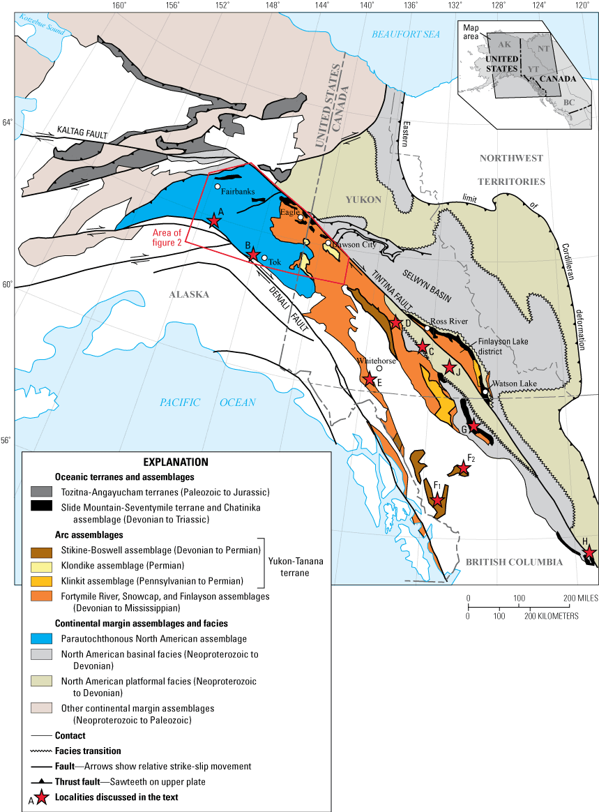
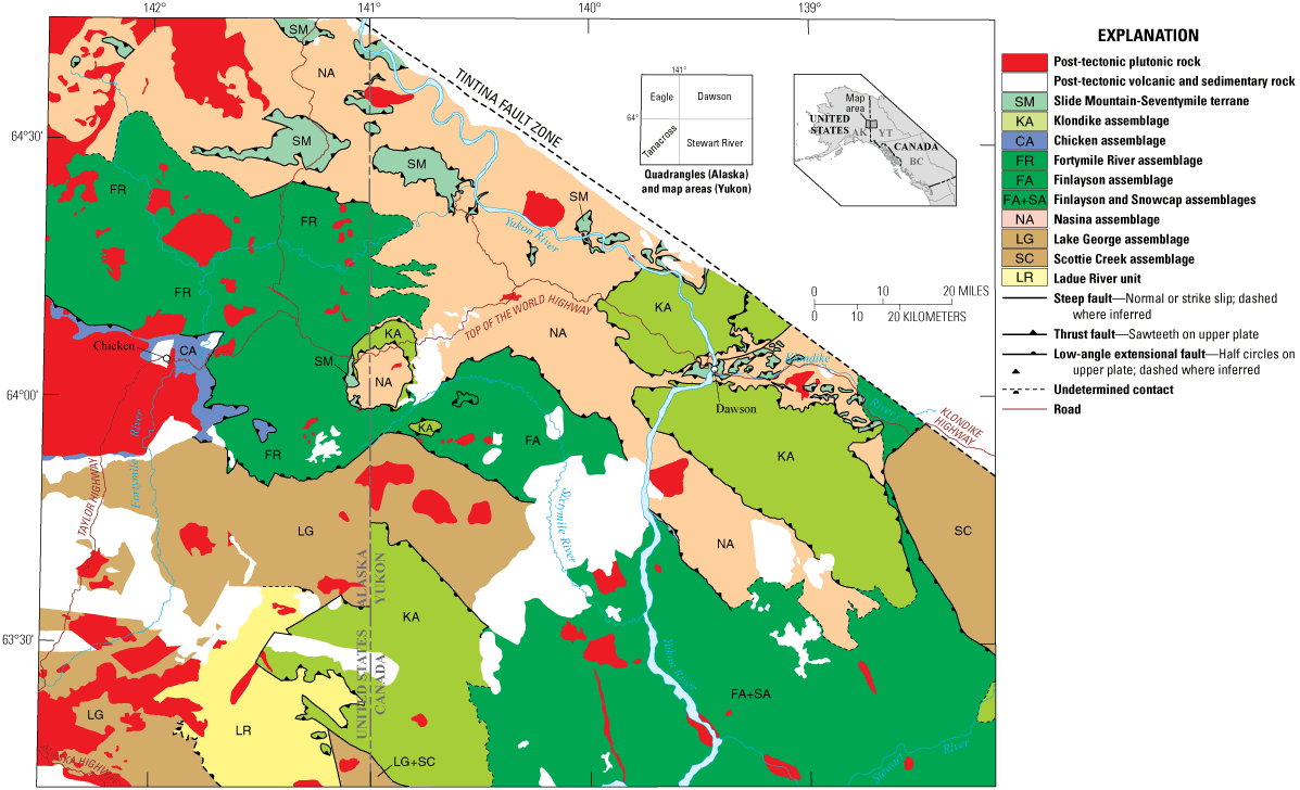
Map of Paleozoic tectonic assemblages of the northern Cordillera in Alaska and northwestern Canada (modified from Dusel-Bacon and others, 2006, 2015; Nelson and others, 2006). Red outline shows location of figure 2. Stars show localities discussed in the text: A, Bonnifield mining district, northern Alaska Range; B, Delta mining district, central Alaska Range; C, Location of syenite dating sample in Pelly Mountains, Cassiar Platform, southern Yukon; D, Glenlyon map area, southern Yukon, and location of the Dunite Peak ophiolite; E, Takhini assemblage, southern Yukon; F1 and F2, Iskut area, northwestern British Columbia; G, Sylvester allochthon, northern British Columbia; H, Germansen Landing area, southern British Columbia; J, Cassiar terrane, southern Yukon.
The Yukon-Tanana terrane was rifted from and later reaccreted to the continental margin of northwestern Laurentia. The Laurentian continental margin assemblages include the North American basinal facies of the Paleozoic Selwyn basin on the northeast side of the Tintina Fault and the Cassiar terrane (fig. 1) platformal facies that forms the southwest side of the Tintina Fault in the western Pelly Mountains of southeastern Yukon (Nelson and others, 2006). The Slide Mountain-Seventymile terrane (fig. 1) represents remnants of a back-arc basin that separated the Yukon-Tanana terrane from the Laurentian continental margin for much of the late Paleozoic (for example, Nelson and others, 2006). Prior to 2006, the crystalline rocks of the extensive parautochthonous North American continental margin assemblage (fig. 1) were generally regarded as being part of the allochthonous Yukon-Tanana terrane, and the combined parautochthonous North American plus Yukon-Tanana terrane assemblages were interpreted as a thin tectonic flap thrust over autochthonous North America (for example, Tempelman-Kluit, 1979; Churkin and others, 1982; Mortensen, 1992). However, a major regional tectonic synthesis published in 2006 (Colpron and others, 2006a; Dusel-Bacon and others, 2006; Nelson and others, 2006) revised the terminology for terranes and assemblages in east-central Alaska and western Yukon. In this revised scheme, the Yukon-Tanana terrane term applied solely to the components at the higher structural levels in easternmost Alaska and adjacent Yukon, which are widely accepted as being allochthonous. The structurally lower components (parautochthonous North American assemblage) were interpreted to be the parautochthonous continental margin of western North America (Laurentia). Both the Yukon-Tanana terrane and parautochthonous North America assemblages have been dextrally offset hundreds of kilometers by the bounding Tintina and Denali strike-slip fault systems. Approximately 430 kilometers (km) of mostly Eocene displacement has occurred on the Tintina Fault System (Gabrielse and others, 2006) and about 370 km of displacement has occurred on the Denali Fault System since the Early Cretaceous, primarily in the middle Tertiary (Dodds, 1995; Lowey, 1998). Based on stratigraphic and structural correlations, many workers have proposed that, prior to dextral displacement on the Tintina Fault, continental margin terranes north of the thrust north of Fairbanks (fig. 2) (Wickersham-White Mountains-Livengood terranes; Moore and Box, 2016), and the adjoining assemblages in east-central Alaska, including what we show as parautochthonous North American assemblage, would have been adjacent to the Selwyn basin of the North American continental margin (fig. 1) (Weber and others, 1985, 1992; Weber, 1990; Beaudoin and others, 1994; Dover, 1994; Murphy and Abbott, 1995; Gabrielse and others, 2006; Mair and others, 2006; Murphy, 2019). Precambrian detrital zircons from the Wickersham grit unit of Weber and others (1985) also support a North American source for detritus in this unit (Bradley and others, 2007).
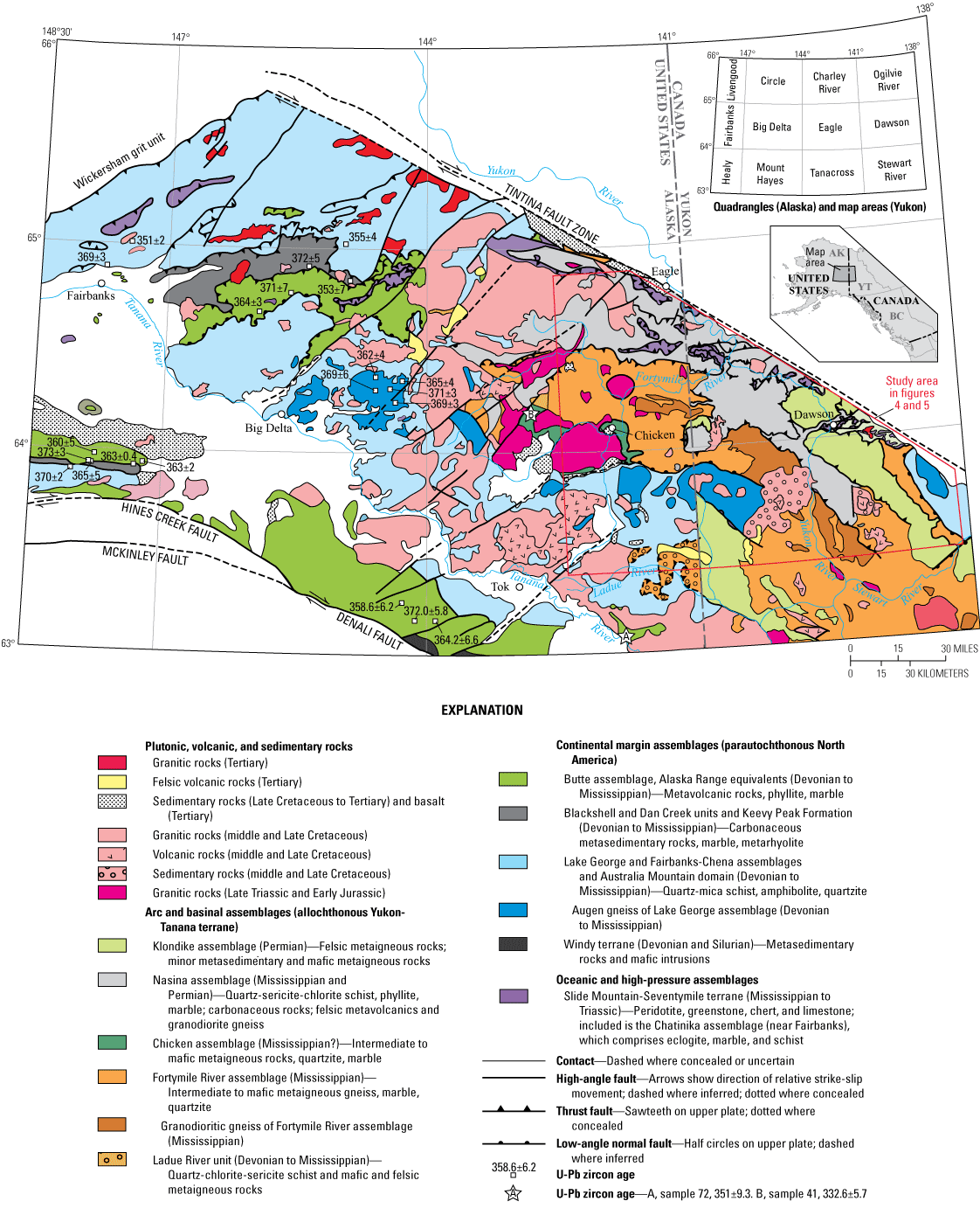
Generalized geologic map of western Yukon and eastern Alaska showing Mesozoic and Cenozoic granitoids; Paleozoic arc, basinal, and continental margin assemblages; oceanic rocks; and locations of previously determined U-Pb zircon ages (in mega-annum [Ma]) outside of the study area (modified from Dusel-Bacon and others, 2017). Geology in Alaska modified from Foster (1992) and Dusel-Bacon and others (2002, 2006) and in Yukon from Mortensen (1988, 1996), Gordey and Ryan (2005), and additional geologic mapping by Mortensen from 1983–2012. References for U-Pb zircon ages (white squares) are given by Dusel-Bacon and others (2006) and updated U-Pb ages for two samples in the Healy quadrangle of the Alaska Range are given by Dusel-Bacon and others (2012) and Slack and others (2019). References for U-Pb zircon ages for samples 41 (star labeled B) and 72 (star labeled A) are given in table 1. Uncolored areas are Neoproterozoic and younger sedimentary rocks north of the Tintina Fault and Quaternary surficial deposits elsewhere. Red outline shows the location of figures 4 and 5, which we have updated from the geology mapped here.
The rationale for this two-component interpretation of the geology in east-central Alaska was proposed on the basis of differing (1) deformational histories and metamorphic cooling ages with primarily Early Jurassic ages recorded in upper plate (Yukon-Tanana terrane) tectonites and Early Cretaceous ages in lower plate tectonites (parautochthonous North American assemblage) (Pavlis, 1989; Hansen, 1990; Hansen and others, 1991; Hansen and Dusel-Bacon, 1998; Dusel-Bacon and others, 2002); (2) ages of magmatic episodes (Permian, Late Triassic, and Early Jurassic subduction-associated magmatic episodes recorded in the Yukon-Tanana terrane, but absent in the parautochthonous North American assemblage); and (3) whole-rock trace-element compositions of mafic and felsic metaigneous rocks indicating within-plate (extensional) tectonic affinities for some Late Devonian to Early Mississippian metaigneous rocks in parautochthonous North America, as opposed to arc- and back-arc-like tectonic affinities for Yukon-Tanana terrane rocks in east-central Alaska (Dusel-Bacon and Cooper, 1999; Dusel-Bacon and others, 2004, 2006).
A more recent line of possible evidence for differing histories of the proposed parautochthonous and allochthonous components is the differing ages for detrital zircon spectra in the two components. Detrital zircon age spectra from parautochthonous units in the northern Alaska Range and western Yukon-Tanana Upland have major Paleoproterozoic (about 1.8 giga-annum [Ga]) and subdominant Neoarchean (about 2.6 Ga) peaks, secondary peaks between those ages, a few samples with minor Mesoproterozoic peaks, and no Paleozoic populations (Dusel-Bacon and others, 2017). The zircon populations of these samples match those from Neoproterozoic to Ordovician North American passive margin strata from British Columbia (Gehrels and Pecha, 2014). In contrast, detrital zircons from Early Mississippian to late Paleozoic strata in the allochthonous Yukon-Tanana terrane from central Yukon to southern British Columbia have Archean, Paleoproterozoic, and minor Mesoproterozoic populations that resemble those from the inferred parautochthonous rocks, but differ from them in that they also include Phanerozoic populations with Devonian and Early Mississippian ages (Gleeson and others, 2000; Colpron and others, 2006b; Murphy and others, 2006; Nelson and Gehrels, 2007; Holm-Denoma and Jones, 2016).
Late Devonian and Early Mississippian metaigneous rocks make up a fundamental component of the crystalline rocks in both the Yukon-Tanana terrane and parautochthonous North American assemblage of the Yukon-Tanana Upland in east-central Alaska and the Yukon Plateau in adjacent Yukon (fig. 2). The age, composition, and tectonic origins of these metaigneous rocks have been addressed in many previous studies (for example, Dusel-Bacon and Aleinikoff, 1985; Mortensen, 1990, 1992; Hansen and Dusel-Bacon, 1998; Dusel-Bacon and others 2004, 2006; Piercey and others, 2006; Ruks and others, 2006). Based on U-Pb zircon data available at the time, Dusel-Bacon and others (2006) suggested that middle Paleozoic magmatism, locally bimodal with extensional trace-element signatures, began earlier in the parautochthon and continued later in the allochthon. Of 32 total U-Pb zircon ages for metaigneous rocks interpreted to be part of the parautochthon in those areas reported by Dusel-Bacon and others (2006), 24 are between 372±6 and 360±5 mega-annum (Ma) (including one previously younger age reanalyzed subsequent to that paper), and 8 are between 359±6 and 347±5 Ma. In contrast, Dusel-Bacon and others (2006) reported generally younger, mainly Mississippian (361±3 to 341±5 Ma) ages for metaigneous rocks in the eastern Yukon-Tanana Upland (Fortymile River and Nasina assemblages).
This paper provides 40 new U-Pb zircon ages and 20 geochemical results for an extensive suite of metaigneous rocks and one undeformed dike from throughout the Yukon-Tanana terrane and parautochthonous North American assemblage in western Yukon and eastern Alaska. In addition, we have compiled recent mapping of the region by a variety of authors, along with all previously published ages, into an integrated map. Our work clarifies the character and geochemistry of assemblages and their relations, serves as a new test for the parautochthonous versus allochthonous interpretation for the parautochthonous North American assemblage, and provides a basis for future studies in the region. Our new U-Pb zircon ages are discussed together with many other published U-Pb ages for Paleozoic rocks in the study area from previous studies, including those by Mortensen (1990), Day and others (2002), Ruks and others (2006), Beranek and Mortensen (2011), Solie and others (2014, 2019), van Staal and others (2018), and Todd and others (2019). A substantial number of additional U-Pb zircon ages from the area have been produced by J.J. Ryan and others at the Geological Survey of Canada, and by M.M. Allan at the Mineral Deposit Research Unit at the University of British Columbia. These two groups of ages have been compiled as part of the Yukon Geochronology database (Yukon Geological Survey, 2020a). Altogether there are currently 74 U-Pb zircon ages available for Paleozoic metaigneous rock units in the study area.
For purposes of discussion, we use the geologic time scale age divisions of the International Chronostratigraphic Chart, version 2020/01 (Cohen and others, 2013, updated). However, instead of the 358.9±0.4 Ma age for the Devonian-Mississippian boundary cited by Cohen and others (2013), for which there are biostratigraphic problems, in this paper we use an age of 361 Ma, based on a Re-Os age for black shales that indicates an age of 361.3±2.4 Ma for a section in the western Canada sedimentary basin (Selby and Creaser, 2005), which closely agrees with a U-Pb zircon age of 360.7±0.7 Ma (Trapp and others, 2004) for a well-studied section in Germany.
Tectonic Setting
The quartz-rich composition of the supracrustal metaclastic rocks, and the common presence of Neoarchean and Paleoproterozoic detrital zircon ages from metasedimentary rocks (Nelson and Gehrels, 2007; Piercey and Colpron, 2009; Gehrels and Pecha, 2014; Dusel-Bacon and others, 2017) and zircon inheritance ages in felsic igneous rocks (Aleinikoff and others 1986; Dusel-Bacon and Aleinikoff, 1996; Dusel-Bacon and Williams, 2009) in both the parautochthonous North American assemblage and Yukon-Tanana terrane are consistent with these rocks having formed by recycling of old crust along the northwestern continental margin of Laurentia. In addition, geochemical studies of metaigneous rocks from throughout the Yukon-Tanana terrane and parautochthonous North American assemblage show strong contamination of mantle-derived magmas by felsic continental crust, as well as derivation of some felsic igneous suites primarily by melting of continental crust (for example, Piercey and others, 2006).
Late Devonian to Early Mississippian magmatism in the northern Cordillera occurred during a tectonic scenario that evolved from rifting of a continental fragment (Yukon-Tanana terrane) from the northwestern margin of Laurentia to subsequent arc and back-arc magmatism in both the Yukon-Tanana terrane and parautochthonous North American assemblage above a northeast-dipping (present coordinates) subduction zone (Nelson and others, 2002; Dusel-Bacon and others, 2006, 2013; Piercey and others, 2006) (fig. 3A). The model also explained the occurrence of middle Paleozoic submarine hydrothermal deposits across the components of this entire tectonic regime (for example, Piercey and others, 2001; Nelson and others, 2002; Dusel-Bacon and others, 2012). In this model, the northeast-dipping subduction, combined with slab rollback, resulted in extension of the broad continental margin and formation of a back-arc basin in which the Slide Mountain Ocean separated the rifted Yukon-Tanana terrane from the parautochthonous North American assemblage for much of the late Paleozoic (fig. 3A, B) (for example, Nelson and others, 2006). A recently proposed hypothesis (van Staal and others, 2018; Parsons and others, 2019123) argues that the Slide Mountain-Seventymile terrane (the Slide Mountain and Seventymile names apply to the oceanic terrane in Yukon and Alaska, respectively) also includes parts of a middle Permian intra-oceanic arc that formed as a result of east-dipping subduction in a suprasubduction-zone setting within the Slide Mountain Ocean basin, between the Yukon-Tanana terrane and western Laurentia.
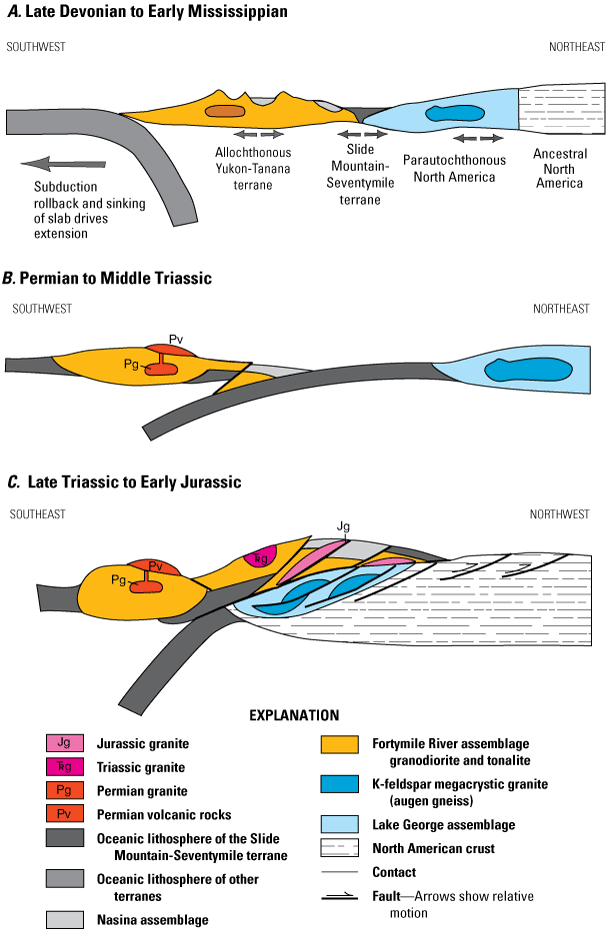
Schematic model for tectonic evolution of western Yukon and eastern Alaska from the Late Devonian to Early Jurassic. A, Middle Paleozoic widespread extension and accompanying magmatism across a broad margin of western Laurentia. Modified from Nelson and others (2002), based on data available from Dusel-Bacon and others (2006, 2013). B, Middle Permian to Middle Triassic west-dipping subduction beneath the outboard Yukon-Tanana terrane. C, Late Triassic closure of most, if not all, of the Slide Mountain Ocean, development of a new east-dipping subduction zone, and associated Late Triassic plutonism in the Yukon-Tanana terrane. In Alaska, continued Early Jurassic subduction beneath the continental margin resulted in orogen-parallel (top-to-the-northwest) thrusting, internal imbrication within both the Yukon-Tanana terrane in the upper plate and parautochthonous North American assemblages in the lower plate, intrusion of syn-kinematic to slightly post-kinematic intrusions, and rapid cooling of upper plate rocks approximately 186 million years ago (Dusel-Bacon and others, 2002, 2015).
In the late Permian, subduction polarity changed to west-dipping (present coordinates) subduction of the Slide Mountain Ocean lithosphere beneath the Yukon-Tanana terrane, resulting in continental-arc magmatism only in the upper plate Yukon-Tanana terrane (Mortensen, 1992; Dusel-Bacon and others, 2006; Piercey and others, 2006; Ruks and others, 2006; Beranek and Mortensen, 2011; fig. 3B). This subduction geometry culminated with closure of the Slide Mountain Ocean and collision between the Yukon-Tanana terrane and the Laurentian margin, producing the Klondike orogeny in the latest Permian to earliest or Middle Triassic (Beranek and Mortensen, 2011).
By the Late Triassic and Early Jurassic, most, if not all, of the Slide Mountain Ocean basin had closed and a new southeast-dipping subduction zone had developed, as indicated by arc granitoids of this age in the Yukon-Tanana terrane in Alaska (Dusel-Bacon and others, 2002; 2015) and Yukon (Johnston and others, 1996; Colpron and others, 2016; Sack and others, 2020) (fig. 3C). There are no documented examples of Late Triassic to Early Jurassic calc-alkaline plutons that intrude rocks inferred to be part of parautochthonous North America that originated east of the Slide Mountain-Seventymile terrane (Hansen and Dusel-Bacon, 1998; Dusel-Bacon and others, 2002, 2015). Early Jurassic subduction beneath the continental margin resulted in orogen-parallel (top-to-the-northwest) thrusting and internal imbrication within both the Yukon-Tanana terrane in the upper plate and parautochthonous North American assemblage in the lower plate (Hansen and Dusel-Bacon, 1998; Dusel-Bacon and others, 2002, 2015). Slide Mountain-Seventymile oceanic rocks now structurally overlie or are imbricated with the parautochthonous North American assemblage and Yukon-Tanana terrane.
Regional Tectonic Assemblages
Our study area is located within the Yukon-Tanana Upland and the adjacent Yukon Plateau in eastern Alaska and western Yukon, respectively (fig. 2). The region is mainly underlain by variably deformed and metamorphosed volcanic, sedimentary, and plutonic rocks, all of which have been intruded by Mesozoic and early Paleogene intrusions and locally overlain by Cretaceous and early Cenozoic volcanic and sedimentary strata. The metamorphic rocks have been divided into several distinct tectonic assemblages. The concept of “tectonic assemblages” was proposed by Gabrielse and others (1991) who described them as a grouping of related units into assemblages that reflect specific tectonic or depositional environments and may comprise one or more formations from a single region or from several separate regions. Colpron and others (2006a) utilized the terminology in describing four Paleozoic tectonic assemblages within the Yukon-Tanana terrane of Yukon and northern British Columbia that correspond to coherent lithologic successions, each of which records a distinct geodynamic setting (continental margin, arc or back-arc basin, and ocean basin). We follow and expand on that terminology herein.
The tectonic assemblages shown in figure 2 are based on map relations, lithology, geochronology, geochemistry, and, in some cases, metamorphic grade and cooling history (Foster and others, 1994, Dusel-Bacon and others, 1995, 2006; Mortensen, 1996; Hansen and Dusel-Bacon, 1998; Colpron and others, 2006a). The assemblages are divided into parautochthonous assemblages of North America, allochthonous assemblages of the Yukon-Tanana terrane, and oceanic Slide Mountain-Seventymile terrane plus high-pressure metamorphic (eclogite) Chatinika assemblage (Dusel-Bacon and others, 2006). The parautochthonous assemblages are interpreted to be primarily continental margin assemblages, whereas the allochthonous assemblages are interpreted to be primarily arc and basinal assemblages; both assemblages were intruded by middle Paleozoic granitoids (shown as dark blue for the parautochthonous Lake George assemblage and dark brown for the allochthonous Fortymile River assemblage in fig. 2). The level of geological mapping and the amount of available geochronological and geochemical data are highly variable across the region, owing both to remoteness as well as poor exposure. Hence, substantial problems concerning the composition of, and relations between, the various assemblages remain.
The northwesternmost parautochthonous assemblage in the Yukon-Tanana Upland, the Fairbanks-Chena assemblage, crops out south of the Wickersham grit unit (fig. 2). This assemblage is composed primarily of greenschist- and amphibolite-facies quartzite and quartz schist and has minor interlayered pelitic schist, calc-silicate rocks, mafic schist, and marble (Foster and others, 1994; Dusel-Bacon and others, 2006, and references therein). Greenschist-facies carbonaceous and siliceous metasedimentary rocks, calc-phyllite, minor marble and quartzite, and felsic and mafic metavolcanic and subordinate metaplutonic rocks (green and dark gray units in the Big Delta quadrangle in fig. 2) crop out in the western Yukon-Tanana Upland. Compositionally and age equivalent rocks are present south of the Tanana River along the north flank of the Alaska Range (light blue, green, and dark gray units in fig. 2), and are described by Dusel-Bacon and others (2004, 2006). These Alaska Range rocks host the Bonnifield and Delta mining districts (fig. 1, localities A and B, respectively) in the Healy and Mount Hayes quadrangles (fig. 2) (Dusel-Bacon and others, 2006, 2012).
The parautochthonous Lake George assemblage crops out in the central Yukon-Tanana Upland in the Big Delta and Tanacross quadrangles and consists of amphibolite-facies pelitic and siliciclastic metasedimentary rocks and minor mafic and rare felsic metaigneous rocks, as well as large conformable bodies of peraluminous augen-bearing and biotite orthogneisses (shown in dark blue in fig. 2). The structurally overlying allochthonous assemblages of the Yukon-Tanana terrane comprise the eastern part of the region in the eastern Eagle and Tanacross quadrangles in Alaska and most of the Stewart River map area and the southwestern part of the Dawson map area in western Yukon. Because the Lake George assemblage and the Yukon-Tanana terrane assemblages and their relation to each other are the primary subjects of our study, they are described in detail in the following sections.
Stratigraphic relations between the various assemblages in the Yukon-Tanana Upland and Yukon Plateau can be difficult to decipher owing to poor exposure, limited paleontologic and radiometric age control, and incomplete detailed and systematic geological mapping. Differing hypotheses have been presented for many of the key tectonic relations in the region, a result of the paucity of unambiguous stratigraphic relations and of kinematic data. For example, the northwestern margin of the Fairbanks-Chena assemblage (thrust boundary shown on fig. 2) has been interpreted as both (1) a major zone of northwest-directed thrusting in which greenschist-facies quartzite and quartz-rich schist were tectonically emplaced on top of the Neoproterozoic to early Cambrian Wickersham grit unit (Foster and others, 1983; Laird and Foster, 1984), as shown on figure 2, and (2) as a downward gradational contact of the Fairbanks-Chena assemblage into the Wickersham grit unit, with both units being correlative with the Neoproterozoic Windermere Supergroup of the Canadian Cordillera that makes up part of the North American continental margin (Weber and others, 1985, 1992; Gabrielse and Campbell, 1991). Several subsequent workers (Dover, 1994; Murphy and Abbott, 1995) also correlated units north of Fairbanks, including the Wickersham grit and the Fairbanks schist (as originally defined by Robinson and others, 1990), with units of unambiguous North American affinity across the Tintina Fault in the western Selwyn basin, based on stratigraphic as well as deformational similarities. These interpretations are early lines of evidence for the parautochthonous (that is, located near its original place of origin, but displaced, in this case by the dextral Tintina Fault) nature of these rock units.
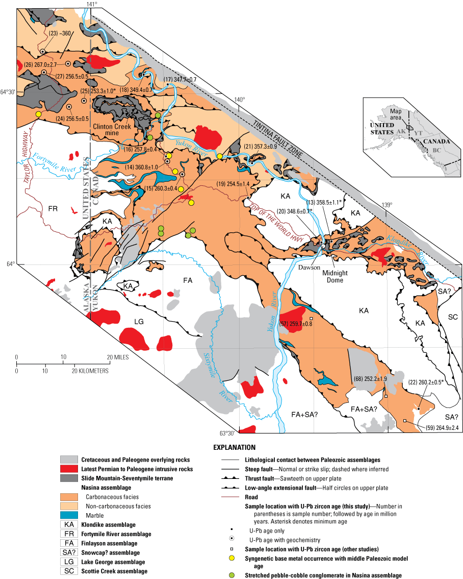
We have compiled a new geological map of the study area (fig. 4), based on all available information from published sources as well as results of our own geological mapping. On this figure, we show the locations and U-Pb zircon crystallization ages of samples dated in our study (nos. 1–40) and those from previously published studies (nos. 41–74); information about the dated samples is given in tables 1 and 2. Previous attempts to link geology across the Alaska-Yukon border based on published regional-scale (1:250,000) geological mapping of the Tanacross and Eagle quadrangles in Alaska by the U.S. Geological Survey (Foster, 1970, 1976) and the Stewart River and Dawson map areas in Yukon by the Geological Survey of Canada (Tempelman-Kluit, 1974; Mortensen, 1988) highlighted numerous correlation problems, and many substantial “border faults” resulting from mapping by different geologists in adjacent areas, especially across the Alaska-Yukon international boundary. Subsequent, more detailed mapping by the Alaska Division of Geological and Geophysical Surveys and U.S. Geological Survey in Alaska (Werdon and others, 2001; Szumigala and others, 2002; Jones and others, 2017a, b; Solie and others, 2019; Twelker and others, 2019; Wypych and others, 2019a164175), and by the Geological Survey of Canada (Gordey and Ryan, 2005), Mortensen (1996), and additional work by Mortensen in 1986–2004 in Yukon, together with extensive comparative work on both sides of the border by the authors and others, have helped to minimize these “border faults.” Regardless, some points of disagreement remain.
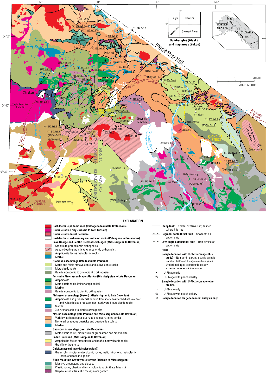
Geological compilation map of the study area in western Yukon and eastern Alaska showing locations and ages (in millions of years ago [Ma]) of U-Pb zircon samples and new whole-rock geochemistry samples from this study (underlined ages; table 2) and other relevant, previously published U-Pb zircon ages from other studies (table 1). Lithological descriptions, locations, and references for all samples are given in tables 1 and 2. An asterisk following a U-Pb zircon age denotes a minimum age (table 2). The geology of the Stewart River map area is from a 1:250,000-scale compilation map by Gordey and Ryan (2005) that includes mapping of the western and northern parts of the map sheet by Tempelman-Kluit (1974) and Mortensen (1996), respectively. The geology of the southwestern Dawson map area is from Mortensen (1988) and additional mapping by Mortensen in 1986–2004, summarized by the Yukon Geological Survey, 2020b). Additional detail in the Klondike mining district is from Mortensen and others (2019) and additional mapping by Mortensen in 1990–2012, and areas to the southeast of the Klondike district are from Staples and others (2013, 2016). The regional geology of the Tanacross and Eagle quadrangles in eastern Alaska is from 1:250,000-scale maps by Foster (1970) and Foster (1976), respectively, and has been modified by more detailed mapping by the Alaska Division of Geological and Geophysical Surveys in the southeastern Eagle quadrangle by Werdon and others (2001) and Szumigala and others (2002), and in the northeastern and eastern Tanacross quadrangles by Solie and others (2019), Twelker and others (2019), and Wypych and others (2019a). Some local detail in eastern Alaska is from a thematic study in the southeastern Eagle quadrangle by Day and others (2002) and a master’s thesis by Flynn (2014). For simplicity, all middle Cretaceous to Paleogene intrusions are shown in red and all Cretaceous and Paleogene volcanic and sedimentary rocks are shown uncolored. Some rock types are present in multiple assemblages; see figure 5 for a simplified map of the assemblages. No geology is mapped north of the Tintina Fault Zone.
Table 1.
Compilation of published U-Pb zircon ages, host assemblages, sample descriptions, and locations of middle and late Paleozoic metaigneous rocks in western Yukon and eastern Alaska.[With the exception of samples 41 and 72, shown by stars on figure 2, all samples are shown on figure 4 and, for Nasina assemblage samples, also on figure 7. Latitude and longitude coordinates are relative to the North American Datum of 1983 (NAD 83). Quadrangle (in Alaska) and map area (in Yukon) names are abbreviated as follows: EA, Eagle; DA, Dawson; SR, Stewart River; TA, Tanacross. Individual 1:63,360- and 1:50,000-scale quadrangle designations follow quadrangle and map area names, respectively. Abbreviations: Ma, mega-annum; σ, standard deviation; UTM, Universal Transverse Mercator coordinate system; YGS, Yukon Geological Survey]
| Sample no. | U-Pb age ±2σ (Ma) | Field no. | Reference | Assemblage or terrane | State or Territory | Lithology and geologic unit or locale | Latitude | Longitude | UTM zone | UTM Northing | UTM Easting | Quadrangle or map sheet |
|---|---|---|---|---|---|---|---|---|---|---|---|---|
| 41 | 332.6±5.7 | 09AD-264 | Dusel-Bacon and others, 2013 | Chicken | Alaska | Tonalitic mylonite gneiss | 64.2058 | −142.8089 | 7W | 7121190 | 412172 | EA A-3 |
| 42 | 343±4 | 98AD-174 | Day and others, 2002 | Fortymile River | Alaska | Tonalitic gneiss | 64.1708 | −141.2716 | 7W | 7116066 | 486789 | EA A-1 |
| 43 | 356±2 | 81ADb14 | Dusel-Bacon and Aleinikoff, 1996 | Lake George | Alaska | Augen gneiss | 63.7525 | −141.0273 | 7V | 7069431 | 498655 | TA D-1 |
| 44 | 353±4 | 90ADb6 | Dusel-Bacon and Aleinikoff, 1996 | Lake George | Alaska | Augen gneiss | 63.7758 | −141.1095 | 7V | 7072036 | 494603 | TA D-1 |
| 45 | 350.4±5.6 | 79AFr4015 | Dusel-Bacon and Williams, 2009 | Lake George | Alaska | Augen gneiss | 63.7386 | −141.625 | 7V | 7068033 | 469144 | TA C-2 |
| 46 | 368.5±7.5 | 90ET59 | Dusel-Bacon and Williams, 2009 | Lake George | Alaska | Augen-poor gneiss | 63.7788 | −141.6023 | 7V | 7072514 | 470310 | TA D-2 |
| 47 | 347.4±5.1 | 90ADb12 | Dusel-Bacon and Williams, 2009 | Lake George | Alaska | Augen gneiss | 63.908 | −141.8314 | 7V | 7087092 | 459200 | TA D-2 |
| 48 | 370.5±5.9 | 90ADb24 | Dusel-Bacon and Williams, 2009 | Lake George | Alaska | Augen gneiss | 63.8361 | −141.5514 | 7V | 7078868 | 472872 | TA D-2 |
| 49 | 355.0±4.5 | 17AW-017 | Todd and others, 2019 | Lake George | Alaska | Augen gneiss | 63.7627 | −141.204 | 7V | 7070592 | 489940 | TA D-1 |
| 50 | 370.6±9.6 | 17JEA-001 | Todd and others, 2019 | Lake George | Alaska | Orthogneiss | 63.783 | −141.2806 | 7V | 7072871 | 486149 | TA D-1 |
| 51 | 363.8±1.5 | R-35 | Mortensen, 1990 | Scottie Creek | Yukon | Mount Burnham orthogneiss | 63.6933 | −138.2833 | 7V | 7065694 | 634304 | SR 115O/09 |
| 52 | ~360 | 03RAYP037A1 | J.J. Ryan, Natural Resources Canada, oral comm., 2020; YGS, 2020b | Scottie Creek | Yukon | Mount Burnham orthogneiss | 63.6943 | −138.2827 | 7V | 7065805 | 634329 | SR 115O/09 |
| 53 | 261.0±2.4 | KP-3 | Mortensen, 1990 | Klondike | Yukon | Felsic metaporphyry | 63.9517 | −139.34 | 7V | 7092686 | 581331 | SR 115O/14 |
| 54 | 263±4 | KP-1 | Mortensen, 1990 | Klondike | Yukon | Felsic metavolcanic rock | 63.9617 | −139.345 | 7V | 7093800 | 581053 | SR 115O/14 |
| 55 | 262.4±2.2 | R-59 | Mortensen, 1990 | Klondike | Yukon | Sulphur Creek orthogneiss | 63.6333 | −138.7067 | 7V | 7058192 | 613621 | SR 115O/10 |
| 56 | 259.0±0.8 | 01M-36 | Beranek and Mortensen, 2011 | Klondike | Yukon | Sulphur Creek orthogneiss | 63.8696 | −139.495 | 7V | 7083332 | 573953 | SR 115O/14 |
| 57 | 259.7±0.8 | 01M-38 | Beranek and Mortensen, 2011 | Nasina | Yukon | Foliated orthogneiss layer in carbonaceous Nasina assemblage (Sulphur Creek orthogneiss) | 63.8386 | −139.5139 | 7V | 7079882 | 573106 | SR 115O/13 |
| 58 | 362.1±2.7 | VN-01-09 | Ruks and others, 2006 | Finlayson | Yukon | Tenderfoot Creek augen gneiss | 63.2794 | −139.2299 | 7V | 7017945 | 588780 | SR 115O/06 |
| 59 | 264.9±2.4 | 03RAY316A2 | Ruks and others, 2006 | Nasina | Yukon | Wounded Moose Dome orthogneiss (Sulphur Creek orthogneiss) | 63.6943 | −138.2877 | 7V | 7065796 | 634082 | SR 115O/10 |
| 60 | 343.7±1.4 | LJJMP-076 | J. Peter, Geological Survey of Canada, written comm., 2012 | Finlayson | Yukon | Augen orthogneiss, Lucky Joe locale | 63.62 | −139.57 | 7V | 7055459 | 570879 | DA 115O/12 |
| 61 | 349.8±1.4 | 03RAY279A2 | YGS, 2020a | Finlayson | Yukon | Quartz monzonite orthogneiss | 63.58 | −139.18 | 7V | 7051508 | 590342 | SR 115O/11 |
| 62 | 345.3±1.7 | 03RAY084A1 | YGS, 2020a | Finlayson | Yukon | Monzogranite | 63.48 | −139.32 | 7V | 7040173 | 583690 | SR 115O/06 |
| 63 | 355.0±1.8 | 03RAY293A2 | YGS, 2020a | Finlayson | Yukon | Tonalitic orthogneiss | 63.39 | −138.87 | 7V | 7030820 | 606435 | SR 115O/07 |
| 64 | 354±4 | 00VN001B | YGS, 2020a | Finlayson | Yukon | Tonalite/diorite orthogneiss | 63.44 | −139.66 | 7V | 7035324 | 566850 | SR 115O/05 |
| 65 | 345.3±1.6 | 03RAY287A2 | YGS, 2020a | Finlayson | Yukon | Foliated monzogranite | 63.45 | −140.05 | 7V | 7036073 | 547380 | SR 115N/09 |
| 66 | 261.1±0.4 | 02RAY102A1 | YGS, 2020a | Klondike | Yukon | Granodiorite-tonalite (Sulphur Creek orthogneiss) | 63.29 | −140.55 | 7V | 7017945 | 522569 | SR 115N/07 |
| 67 | ~260 | 02RAY-110A1 | YGS, 2020a | Klondike | Yukon | Augen monzogranite orthogneiss (Sulphur Creek orthogneiss) | 63.29 | −140.52 | 7V | 7018090 | 524063 | SR 115N/07 |
| 68 | 252.2±1.9 | YGR-EU-005 | YGS, 2020a | Nasina | Yukon | Hornblende-feldspar porphyry (Sulphur Creek orthogneiss) | 63.48 | −138.89 | 7V | 7040802 | 605105 | SR 115O/11 |
| 69 | 351.5±1.5 | JRFR10D0004 | YGS, 2020a | Finlayson | Yukon | Intermediate-composition metaplutonic rock | 63.44 | −139.17 | 7V | 7035954 | 591295 | SR 115O/06 |
| 70 | 350.5±0.9 | JRSA10D002 | YGS, 2020a | Finlayson | Yukon | Intermediate-composition metaplutonic rock | 63.43 | −139.23 | 7V | 7034729 | 588277 | SR 115O/06 |
| 71 | 354.6±9.3 | 09MBW-243A | Solie and others, 2014 | Lake George | Alaska | Granitic orthogneiss on Alaska Highway | 63.2453 | −142.39 | 7V | 7013671 | 430194 | TA A-3 |
| 72 | 351.7±9.3 | 09MBW-400A | Solie and others, 2014 | Lake George | Alaska | Felsic metavolcanic rock on Alaska Highway | 63.0504 | −141.8332 | 7V | 6991478 | 457869 | TA A-2 |
| 73 | 264±4 | VL010-09 | van Staal and others, 2018 | Slide Mountain | Yukon | Greenstone/diabase on road to Midnight Dome near Dawson | 64.0589 | −139.3869 | 7W | 7104571 | 578726 | DA 116B/03 |
| 74 | 265±3 | VL010-12 | van Staal and others, 2018 | Slide Mountain | Yukon | Gabbro cutting ultramafic rocks at Clinton Creek mine | 64.4456 | −140.7121 | 7W | 7146707 | 513855 | DA 116C/07 |
Table 2.
U-Pb zircon ages, host assemblages, sample descriptions, and locations for middle and late Paleozoic metaigneous rocks in western Yukon and eastern Alaska from this study.[Digital data available from Dusel-Bacon and Mortensen (2023). Samples 1–39 are shown on figure 4; samples 13–27 are also shown on figure 7. Sample 40 is shown as location C on figure 1. Latitude and longitude coordinates are relative to the North American Datum of 1983 (NAD 83). Quadrangle (in Alaska) and map area (in Yukon) names are abbreviated as follows: EA, Eagle; DA, Dawson; SR, Stewart River; TA, Tanacross. Individual 1:63,360- and 1:50,000-scale quadrangle designations follow quadrangle and map area names, respectively. Abbreviations and symbols: avg, average; Dev., Devonian; Ga, giga-annum; ID-TIMS, isotope dilution thermal ionization mass spectrometry; LA-ICP-MS, laser ablation inductively coupled plasma mass spectrometry; Ma, mega-annum; Miss., Mississippian; σ, standard deviation; —, not applicable]
Figure 5 is a simplified version of our new geological compilation map (fig. 4) and shows the distribution of the lithotectonic assemblages in the study area and their inferred structural relations. Most original contacts between the various assemblages are thought to be thrust faults; however, late Mesozoic and Paleogene steep faults and Early Cretaceous low-angle extensional faults are superimposed on this older structural geometry and produce a more complex map pattern (for example, Hansen and Dusel-Bacon, 1998; Sánchez and others, 2014; Jones and others, 2017a; Ryan and others, 2017141). In some parts of the study area, the exact nature of the boundaries between assemblages is still uncertain because of poor exposure and an absence of detailed mapping.
Simplified version of the new geological compilation map (fig. 4) of the study area in western Yukon and eastern Alaska, highlighting individual lithotectonic assemblages and the nature of the main bounding and internal contacts.
Parautochthonous Tectonic Assemblages
Lake George and Scottie Creek Assemblages
The quartz-rich compositions of many metasedimentary rocks in the Lake George assemblage in western Yukon-Tanana Upland (fig. 2), together with the presence of Archean and Proterozoic inherited zircons, and radiogenic strontium and neodymium isotopic compositions for Paleozoic and younger igneous rocks within the Lake George assemblage were used to infer a continental origin for the parautochthonous rocks (for example, Aleinikoff and others, 1986; Dusel-Bacon and others, 2004). Aleinikoff and others (1981) reported neodymium isotopic data that correspond to an epsilon neodymium (εNdT) value at time T (age of sample) before present of −19.9 for a sample of Early Mississippian augen gneiss from the Big Delta quadrangle, and Ruks and others (2006) reported εNdT values of −15.3 to −10.7 (number of samples [n] = 4) for samples from the Mount Burnham orthogneiss (of Mortensen, 1990) of the Fiftymile batholith in the western Stewart River map area (fig. 4). Todd and others (2019) reported epsilon hafnium (εHfT) values of −23.57 and −21.75 for zircons from a sample of Late Devonian orthogneiss and Early Mississippian augen gneiss, respectively, in the Lake George assemblage in the northeastern Tanacross quadrangle. All these isotopic data are consistent with magmas that have been highly contaminated by incorporation of continental crust in a continental-margin arc or within-plate setting.
The Lake George assemblage in eastern and east-central Alaska consists of amphibolite-facies pelitic and siliciclastic metasedimentary rocks and minor mafic and rare felsic metaigneous rocks, as well as large conformable bodies of peraluminous augen-bearing and biotite orthogneisses (Dusel-Bacon and Aleinikoff, 1985; Foster and others, 1994; Dusel-Bacon and others, 2006). Augen gneiss and non-augen bearing orthogneiss in the northeastern Tanacross quadrangle have been included in the Divide Mountain augen gneiss suite and the Lake George orthogneiss suite, respectively, by Wypych and others (2019a). The large body of metaplutonic rocks in the northwestern part of the Stewart River map area has previously been referred to as the Fiftymile batholith (Tempelman-Kluit and Wanless, 1980; Mortensen, 1986); however, subsequent mapping by Mortensen (1996) demonstrated that it is not a single body, but rather comprises two distinct metaplutonic units that are separated by a north-dipping Early Cretaceous extensional fault (figs. 2, 4, 5). The batholith south of, and in the footwall of, the fault consists of augen gneiss that is included in the Lake George assemblage, whereas the batholith in the hanging wall of the fault is included in the Yukon-Tanana terrane and correlated with the informal Simpson Range plutonic suite of Colpron and others (2016) (figs. 2, 4, 5). Dusel-Bacon and Aleinikoff (1996) correlated the footwall augen gneiss of the Fiftymile batholith with contiguous rocks in the eastern Tanacross quadrangle and with the Divide Mountain augen gneiss suite. To avoid confusion, in this report we refer to the northern batholithic body in the hanging wall of the extensional fault as the Sixtymile batholith, after the Sixtymile River that traverses it.
Augen gneiss from a large body in the southeastern Big Delta quadrangle in the western part of the Lake George assemblage (fig. 2), approximately 100 km west of our study area (fig. 2), yielded sensitive high-resolution ion microprobe (SHRIMP) U-Pb zircon ages of 371±3, 365±4, and 362±4 Ma (Day and others, 2003; Dusel-Bacon and others, 2004). Mafic gneiss associated with the dated augen gneiss in that body yielded SHRIMP U-Pb zircon ages of 369±3 Ma (Dusel-Bacon and others, 2004) and 369±6 Ma (Day and others, 2003), indicating bimodal Late Devonian magmatism in the Lake George assemblage. Eight other SHRIMP and laser ablation inductively coupled plasma mass spectrometry (LA-ICP-MS) U-Pb zircon ages ranging from 370.6±9.6 to 347.4±5.1 Ma have been reported for other bodies of augen-bearing Divide Mountain suite and augen-free Lake George orthogneiss suite samples in the Lake George assemblage in the northeastern Tanacross quadrangle (fig. 4; samples 43–50 of table 1) by Dusel-Bacon and Aleinikoff (1996), Dusel-Bacon and Williams (2009), and Todd and others (2019). LA-ICP-MS zircon ages of the Lake George assemblage were reported by Solie and others (2014, 2019) for a sample of granitic orthogneiss along the Alaska Highway within our study area (sample 71) and another sample just south of the southwestern part of our study area that was interpreted to be a felsic metavolcanic rock (sample 72) (table 1). The orthogneiss yields an age of 354.6±9.3 Ma (fig. 4) and the metavolcanic rock yields an age of 351.7±9.3 Ma (shown as stars on fig. 2).
The Scottie Creek assemblage, originally defined in the Scottie Creek 1:50,000-scale map of western Yukon, north of Beaver Creek, by Murphy and others (2009) is mapped in the southwestern and eastern parts of the Stewart River map area in western Yukon (Mortensen, 1996; Gordey and Ryan, 2005; Staples and others, 2013) and the northwestern part of the Stevenson Ridge map area (fig. 5). It is a package of mainly metaclastic rocks with minor marble that encloses a large body of granitic augen gneiss (fig. 4; Mortensen, 1996; Gordey and Ryan, 2005; Staples and others, 2013). The augen gneiss units in Yukon have been assigned by Colpron and others (2016) to the informal Grass Lakes plutonic suite, as defined in the Finlayson Lake mining district in southeastern Yukon, east of the Tintina Fault (fig. 1). Rocks of the Lake George and Scottie Creek assemblages are confined to the structural footwall of Early Cretaceous normal faults (figs. 4, 5) and have been interpreted to be gneiss domes, analogous to metamorphic core complexes of the western United States (for example, Hansen and Dusel-Bacon, 1998; Staples and others, 2013; Jones and others, 2017a; Ryan and others, 2017; Wypych and others, 2019a). Amphibolite-facies schist and gneiss of the Scottie Creek assemblage in the northeastern Stewart River map area are intruded by Mount Burnham orthogneiss (Mortensen, 1990; Gordey and Ryan, 2005; fig. 5). These rocks are exposed in a tectonic window, referred to as the Australia Mountain domain (Staples and others, 2013). A sample of the augen gneiss yielded an interpreted isotope dilution thermal ionization mass spectrometry (ID-TIMS) U-Pb zircon age of 363.8±1.5 Ma (Mortensen, 1990; sample 51, fig. 4, table 1). Ruks and others (2006) reported a considerably younger, but poorly constrained, ID-TIMS U-Pb zircon age of 347.5±0.7 Ma for a second sample from the same area. This sample was subsequently re-analyzed using SHRIMP U-Pb methods, however, and the age was revised to approximately 360 Ma (J.J. Ryan, Natural Resources Canada, oral comm., 2020; Yukon Geological Survey, 2020b; sample 52; fig. 4; table 1).
Because of the lithologic and age similarities between the Lake George and Scottie Creek assemblages, as well as the continuity of these rocks across the Alaska-Yukon border in the southern Tanacross quadrangle, we consider them to be parts of the same assemblage.
Allochthonous Tectonic Assemblages
Fortymile River, Finlayson, and Snowcap Assemblages
The Fortymile River assemblage is exposed mainly in the Eagle quadrangle in eastern Alaska. It is made up of thoroughly recrystallized amphibolite-facies biotite gneiss, amphibolite, garnet amphibolite, mafic schist and gneiss, metapelite, quartzite, metachert, marble, and minor metarhyolite and metaporphyry, together with locally abundant feldspathic orthogneiss (primarily of granodioritic, tonalitic, or trondhjemitic composition) that form tabular bodies that are concordant with compositional layering in the host supracrustal rocks, as well as larger massifs (figs. 2, 4, 5) (Foster, 1976; Day and others, 2000, 2002; Werdon and others, 2001; Szumigala and others, 2002; Dusel-Bacon and others, 2006). A body of weakly foliated and epidotized, quartz-biotite-plagioclase granodioritic gneiss (shown in dark brown on fig. 2) crops out within interlayered amphibolite and quartz-biotite schist of the Fortymile River assemblage south of the Fortymile River at about 64°12′ latitude along the Taylor Highway (fig. 4). This unit was referred to as the Steele Creek Dome tonalite or Steele Creek Dome orthogneiss by Day and others (2000) and Day and others (2002), respectively. A SHRIMP U-Pb zircon age of 343±4 Ma (sample 42, fig. 4, table 1) was previously reported from this body (Day and others, 2002). Metasedimentary rocks and local intercalations of mafic and rare felsic metavolcanic rocks are intruded by mainly intermediate-composition metaplutonic bodies that appear to be intimately associated with the metavolcanic units.
The Fortymile River assemblage in Alaska can be mapped continuously with rock units that are assigned to the Finlayson assemblage in the southwestern Dawson map area and northwestern Stewart River map area on the most recent version of the digital Yukon Bedrock Geology compilation (Yukon Geological Survey, 2020b) (figs. 4, 5). The Finlayson assemblage was originally defined in the Finlayson Lake district in southeastern Yukon, east of the Tintina Fault (fig. 1) (Murphy and others, 2006). After restoration of motion on the Tintina Fault, the Finlayson Lake district would have been in part adjacent to rocks of the Yukon-Tanana terrane in western Yukon and eastern Alaska. The Finlayson assemblage, as defined in the Yukon Bedrock Geology compilation, mainly consists of metamorphosed and deformed mafic to felsic metavolcanic rocks, carbonaceous pelite, and metachert. Mapping by Mortensen (1996) and additional mapping by Mortensen in 1983–2012 demonstrate that the rock units mapped as Finlayson assemblage in the Dawson map area consist mainly of metaclastic rocks that closely resemble those in the Fortymile River assemblage to the west but have less abundant metavolcanic units.
Farther to the southeast in the Stewart River map area, amphibolites of the Finlayson assemblage are interspersed with metaclastic rocks that have been assigned by Ryan and others (2013) to the Snowcap assemblage; the amphibolites are also interspersed with numerous bodies of marble, as well as small bodies and larger massifs of mainly intermediate-composition orthogneiss. The Snowcap assemblage is interpreted to comprise the oldest stratigraphic units in the Yukon-Tanana terrane. The Snowcap assemblage was originally defined in the Glenlyon area in central Yukon (fig. 1, locality C), south of our study area (Colpron and others, 2006b). There it consists of a Devonian and possibly older mainly metaclastic assemblage that contains 1- to 10-meter (m)-thick horizons of amphibolite and greenstone, on which the Finlayson assemblage volcano-sedimentary assemblage was deposited (Colpron and others, 2006b; Piercey and Colpron, 2009). Our own observations in numerous localities along the Yukon River in the Stewart River map area, however, agree with Ryan and others’ (2003) interpretation that at least some of the metaclastic rocks in this region are coeval with amphibolites (mafic metavolcanic rocks) of the Finlayson assemblage. Also, several samples of metaclastic rocks that are shown as Snowcap assemblage in compilation maps (Yukon Geological Survey, 2020b) that are closely associated with Finlayson assemblage amphibolites in the Stewart River map area have been shown to contain Late Devonian detrital zircons (Ryan and others, 2003; Cleven and others, 2019), a zircon population that is absent from the type Snowcap assemblage, thus supporting a depositional age for these rocks that coincides with deposition of the Finlayson assemblage. This indicates that the Finlayson assemblage, together with some of the metaclastic rocks presently mapped as Snowcap assemblage and the marble bodies in the Stewart River map area, are collectively correlative with the Fortymile River assemblage as mapped in eastern Alaska.
It is certainly possible that some of the metaclastic rocks in the Stewart River map area are indeed Snowcap assemblage equivalents that are older than the Finlayson assemblage and Fortymile River assemblage; however, the lithological composition of the Snowcap assemblage and the metaclastic component of the Fortymile River and Finlayson assemblages are not sufficiently different to allow them to be readily distinguished. On our compilation maps of the area (figs. 4, 5), we therefore label the metaclastic assemblages as “Snowcap? assemblage” to emphasize the uncertainty of which map units are stratigraphically interlayered with the Finlayson assemblage metavolcanic rocks and which possibly underlie them. Intermediate-composition orthogneiss bodies that are thought to be comagmatic with metavolcanic rocks of the Finlayson assemblage in Yukon have been grouped with the Simpson Range plutonic suite as defined in the Finlayson Lake district in southeastern Yukon (Colpron and others, 2016). They occur throughout both the Finlayson assemblage and the possible Snowcap? assemblage, so their presence or absence does not help distinguish between true Snowcap assemblage rock units that predate the Finlayson assemblage and similar rocks (Snowcap?) that are truly part of the Finlayson assemblage.
U-Pb zircon ages ranging from 355.0±1.8 to 343.7±1.4 Ma have been reported for intermediate to felsic orthogneisses associated with the Finlayson assemblage in the Stewart River map area (samples 60–65, fig. 4, table 1) (Yukon Geochronology Database; Yukon Geological Survey, 2020a). An older interpreted ID-TIMS U-Pb zircon age of 362.1±2.7 Ma was reported by Ruks and others (2006) for a body of granitic potassium-feldspar augen orthogneiss, informally called the Tenderfoot Creek orthogneiss, which is associated with Finlayson assemblage amphibolites and Snowcap? assemblage metaclastic rocks on the Stewart River approximately 10 km upstream from its confluence with the Yukon River (sample 58, fig. 4, table 1).
The Fortymile River assemblage, Finlayson and Snowcap? assemblages, and orthogneiss bodies within them are imbricated by numerous regional-scale thrust faults of probable Early Jurassic age, many of which are marked by discontinuous, lens-shaped, thrust-fault bounded bodies of serpentinized ultramafic rocks assigned to the Slide Mountain-Seventymile terrane (Mortensen, 1996; Gordey and Ryan, 2005). Mapping across the Alaska-Yukon border has shown that mixed metaclastic and mafic metavolcanic rocks of the Fortymile River assemblage intertongue, probably as an original facies change, with variably carbonaceous siliciclastic rocks of the Nasina assemblage (which are designated as sub-unit DMF3 of the Finlayson assemblage on the Yukon Bedrock Geology compilation [Yukon Geological Survey, 2020b]). Rocks of the Fortymile River, Finlayson, and Snowcap? assemblages are juxtaposed against structurally underlying Lake George and Scottie Creek assemblages across Early Cretaceous extensional faults (fig. 5).
An extensive neodymium isotopic database has been generated for rocks of the Finlayson assemblage in the Finlayson Lake district by Grant (1997) and Piercey and others (2003, 2004, 2006). Felsic rocks of the Finlayson assemblage in the Finlayson Lake district and associated metaplutonic rocks mainly yield evolved (crustal) neodymium isotopic signatures (εNdT = −12.9 to +0.1; Piercey and others, 2003), whereas mafic metavolcanic rocks and mafic dikes in the area have more juvenile isotopic signatures (εNdT = −0.3 to +8.5). Some of these mafic rocks are interpreted to represent juvenile arc lavas, whereas others are thought to be somewhat younger magmas related to initial rifting of the Early Mississippian arc and subsequent back-arc magmas (Piercey and others, 2004).
Nasina Assemblage
The Nasina assemblage is a major component of the Yukon-Tanana terrane in the central Stewart River and southwestern Dawson map areas in western Yukon and the northeastern part of the Eagle quadrangle in Alaska (Foster, 1976; Mortensen, 1988, 1990, 1996; Gordey and Ryan, 2005) (figs. 4–6). It mainly consists of strongly deformed and foliated fine-grained siliciclastic rocks, including quartz-mica schist and quartzite. Minor lithologies present include marble layers that are locally as thick as 100 m and 10 km in strike length, as well as rare occurrences of stretched pebble conglomerate and rare muscovite and quartz-muscovite schist layers that are interpreted to be derived from felsic airfall tuff. Several small bodies of moderately to strongly foliated biotite quartz monzonitic orthogneiss occur locally within the Nasina assemblage. Two of these bodies yielded Late Permian U-Pb zircon ages (samples 57 and 68; fig. 4, table 1) and are correlated with the regional Sulphur Creek orthogneiss suite. The Nasina assemblage has mostly been metamorphosed at upper greenschist facies (biotite and garnet grade). Two separate lithological facies in the Nasina assemblage are distinguished by Mortensen (1996) and additional mapping by Mortensen in 1983–2001 (fig. 4); these are a carbonaceous facies, which, in addition to the above-mentioned rock types, typically contains a substantial amount of carbonaceous material and generally weathers medium to dark gray, and a non-carbonaceous facies, which is lithologically similar but generally lacks the carbonaceous component. The Nasina assemblage intertongues with amphibolites of the Fortymile River assemblage in the southwestern Dawson map area just east of the Alaska-Yukon border (figs. 4–6). The Nasina assemblage was interpreted by Colpron and others (2006a) to represent a clastic sequence that was deposited in the Nasina basin, which is thought to have lain broadly in a back-arc position with respect to the Fortymile River assemblage arc.
Detailed geologic map of the Nasina assemblage and related units showing U-Pb zircon ages (in mega-annum [Ma]) (tables 1, 2), occurrences of stretched pebble conglomerate, and syngenetic base metal occurrences in western Yukon and eastern Alaska.
The depositional ages for the Nasina assemblage are difficult to constrain, owing to negligible amounts of volcanic rocks that can be dated and analyzed geochemically, and the strong deformation and metamorphism that have largely obliterated any fossils that might have been present. Some information for the age of the rock units has been obtained from lead isotopic studies of syngenetic base metal occurrences in the Nasina assemblage (fig. 6), which yield middle Paleozoic lead model ages (Mortensen and others, 2006).
Klondike Assemblage
Supracrustal rocks of the Klondike assemblage are mainly exposed in the Klondike and Sixtymile mining districts in Yukon, as well as a large area that straddles the Alaska-Yukon border south of the Fiftymile batholith (fig. 4). The Klondike assemblage in the Stewart River and southwestern Dawson map areas in western Yukon comprises three main lithologies: (1) fine-grained quartz-muscovite schist and quartz (with or without feldspar) augen schist, (2) mafic schist and metagabbro, and (3) fine-grained, non-carbonaceous, quartz-mica schist and quartzite (Mortensen, 1988, 1990, 1996; Gordey and Ryan, 2005). Protoliths of these three middle to upper greenschist-facies lithologies are interpreted to be felsic volcanic and volcaniclastic rocks and associated subvolcanic rocks, mafic to intermediate volcanic rocks and associated mafic intrusions, and fine-grained metaclastic rocks, respectively. Small syngenetic base metal occurrences have been identified in many localities within the Klondike assemblage (Mortensen and others, 2006), indicating that much of the Permian volcanism occurred in a submarine setting.
Weakly to strongly foliated bodies of quartz monzonitic to granitic composition are also associated with the Klondike assemblage; these bodies are collectively termed the Sulphur Creek orthogneiss suite (Colpron and others, 2016), named for a specific body of that name in the southern Klondike district (figs. 4, 5; Mortensen, 1990; Colpron and others, 2016). Middle to late Permian U-Pb zircon ages have been determined for muscovite-quartz schist, interpreted to be metamorphosed felsic tuff, and for several of the quartz monzonitic to granitic metaplutonic bodies (samples 66 and 67; fig. 4, table 1; Mortensen, 1990, 1992; Ruks and others, 2006). Bodies of Sulphur Creek orthogneiss are intimately associated with the felsic metavolcanic units in the Klondike district, but bodies of similar age and composition are also widely distributed throughout the Finlayson and Snowcap? assemblages in Yukon and as rare occurrences in northern Tanacross and east-central Eagle quadrangles in Alaska (fig. 4).
Most contacts of the Klondike assemblage with other assemblages, as well as structures that locally imbricate the Klondike assemblage, are mapped as regional-scale thrust faults and locally are marked by small, fault-bounded bodies of serpentinized ultramafic rocks of the Slide Mountain-Seventymile terrane (fig. 4). Although original stratigraphic relations between the Klondike assemblage and older assemblages are poorly preserved, the presence of the Sulphur Creek orthogneiss bodies both within the Klondike assemblage and throughout the Finlayson and Snowcap? assemblages and, locally, the Nasina assemblage, demonstrates that the Klondike assemblage was originally built on top of the Finlayson, Snowcap?, and Nasina assemblages.
Mortensen (1990) and Beranek and Mortensen (2011) reported TIMS U-Pb zircon ages of 267 to 259 Ma for felsic metavolcanic rocks of the Klondike assemblage and the Sulphur Creek orthogneiss in the Klondike district.
Jones and others (2017b) report preliminary U-Pb zircon ages of approximately 262 Ma for a thin layer of felsic gneiss within metaclastic rocks and amphibolite of the Fortymile River assemblage in northern Tanacross quadrangle and approximately 257 Ma for a granitic pluton in south-central Eagle quadrangle that is interpreted to crosscut the main foliation in Fortymile River assemblage host rocks. Ruks and others (2006) determined εNdT values ranging from −14.0 to −7.1 for seven samples of Permian Sulphur Creek orthogneiss and felsic metavolcanic rocks of the Klondike assemblage, consistent with magmas that have been highly contaminated by incorporation of continental crust in a continental-margin arc or within-plate setting. Crustal contamination is also indicated by the common presence of older inherited zircon in many of the Klondike assemblage metavolcanic rocks and the Sulphur Creek orthogneiss suite (Mortensen, 1990).
Chicken Assemblage
The Chicken assemblage, as we herein rename it, has previously been described in the literature as the “Chicken metamorphic complex” (for example, Werdon and others, 2001; Dusel-Bacon and others, 2006, 2013). Werdon and others (2001) proposed the name “Chicken metamorphic complex” to describe a group of lower greenschist-facies mafic and minor felsic metavolcanic rocks, limestone, metagabbro, metadiabase, slate, quartz-mica phyllite, quartzite, and tonalitic gneiss that crop out along the eastern and southern margins of a large Late Triassic intrusion (Taylor Mountain batholith) in the southern Eagle and northern Tanacross quadrangles (figs. 2, 4, 5; Foster, 1970, 1976; Werdon and others, 2001; Dusel-Bacon and others, 2006, 2013). Another exposure of these rocks extends from the northwestern margin of the Taylor Mountain batholith outside of our study area in the south-central Eagle quadrangle (Foster, 1976; Dusel-Bacon and others, 2013; Day and others, 2014) (fig. 2). The low metamorphic grade of these rocks is markedly different from those of the adjacent Fortymile River and Lake George assemblages, which have experienced amphibolite-facies metamorphism. Because the term “metamorphic complex” implies much higher metamorphic-grade rocks (as in “core complex”) than those in this unit and results in a misconception about their metamorphic history, we hereby abandon that term and instead refer to them informally as the “Chicken assemblage,” retaining the location moniker of the nearby village of Chicken (figs. 2, 4, 5) and adjusting the name to match the other Paleozoic tectonic assemblages in the region. The type area for this assemblage is that shown and described for the “Chicken metamorphic complex” by Werdon and others (2001).
Recrystallized limestone interlayered with massive mafic metavolcanic rocks (greenstone) in the southeastern Eagle quadrangle yielded Paleozoic fossil crinoid columnals (Foster, 1969), and Dusel-Bacon and Harris (2003) described poorly preserved conodonts from the same outcrop area as having a late Paleozoic, possibly Mississippian, age. Foster (1976) originally tentatively correlated the Chicken assemblage with the Slide Mountain-Seventymile terrane because of the prominent mafic metavolcanic rocks that are common to both, but later corrected this correlation because the Chicken assemblage lacks peridotite, which is only present in the Slide Mountain-Seventymile terrane (Foster and others, 1994).
Dusel-Bacon and others (2013) reported a SHRIMP U-Pb zircon age of 332.6±5.7 Ma for a 2-m-thick layer of strongly mylonitized gneiss of tonalitic composition within mafic metavolcanic rocks of the Chicken assemblage in the south-central Eagle quadrangle (table 1, location 41, shown as a star on fig. 2). The protolith of this rock unit is uncertain; it could have been a tonalitic sill or alternatively a dacitic volcanic flow. This relatively young age is different from any ages that have yet been obtained in the Yukon-Tanana terrane in this region.
Ladue River Unit
The Ladue River unit makes up an area in the eastern Tanacross quadrangle of dominantly greenschist-facies quartz-mica schist, mafic and felsic schist, amphibolite, and locally abundant felsic orthogneiss (fig. 4). The relatively low metamorphic grade contrasts with the typical amphibolite-facies mineral assemblages that characterize the adjacent Lake George assemblage. Foster (1970) mapped these rocks as a unit of uncertain Precambrian to Paleozoic age, and correlated these rocks with the Klondike schist unit of Cockfield (1921) across the border in Yukon based on broadly similar lithologies, especially the prominence of quartz-white mica-chlorite schist. As described above, the Klondike schist of Cockfield (1921) has since been shown to be Late Permian in age (Mortensen, 1990, 1992). Dusel-Bacon and others (2006) described these rocks as a new informal unit, termed the Ladue River unit (fig. 2), because of both a Late Devonian U-Pb zircon age obtained from a sample of augen gneiss in the unit, and a normal midocean ridge basalt (N-MORB) geochemical affinity for a metabasite sample in the unit that is completely different from the Klondike assemblage rocks. Dusel-Bacon and others (2006) proposed that the Ladue River unit is better correlated with the higher grade middle Paleozoic Lake George assemblage in which some metabasites have an N-MORB geochemical affinity.
Recent preliminary mapping and geochemical and geochronological studies in this area by Jones and others (2017a, b) and Twelker and others (2019) have determined that the late Permian Klondike assemblage does extend westward across the border into Alaska and forms thin thrust sheets that overlie the Ladue River unit, which is itself interpreted to be restricted to thin thrust sheets that have been thrust over the Lake George assemblage (figs. 4, 5).
Slide Mountain-Seventymile Terrane
The Slide Mountain-Seventymile terrane comprises allochthonous rocks of mainly oceanic affinity in numerous localities throughout southern and western Yukon and eastern Alaska (figs. 2, 4, 5; Keith and others, 1981; Foster and others, 1994; Dusel-Bacon and others, 2006; Yukon Geological Survey, 2020b). The Slide Mountain-Seventymile terrane consists mainly of massive, locally pillowed greenstone, mafic volcaniclastic rocks, radiolarian chert, minor gabbro and diabase, and serpentinized ultramafic rocks (peridotite), some of which have been interpreted to comprise an ophiolite sequence (for example, Keith and others, 1981; Mortensen, 1988; Nelson, 1993; Foster and others, 1994). In eastern and east-central Alaska, the Slide Mountain-Seventymile terrane occurs as several large, structurally imbricated klippen, including serpentinized peridotite, the largest three being the Salcha River klippe in the northwest corner of the Big Delta quadrangle (fig. 2), the Mount Sorenson klippe that spans the northwesternmost Eagle quadrangle and southwesternmost Charley River quadrangle (fig. 2), and the Wolf Mountain klippe astride the Taylor Highway in the northern Eagle quadrangle (fig. 4) (Foster and others, 1994). Somewhat smaller klippen of the Slide Mountain-Seventymile terrane occur as thrust-fault-bounded blocks in the vicinity of the abandoned Clinton Creek asbestos mine and Dawson in the southeastern Dawson map area (fig. 6) (Mortensen, 1988; Yukon Geological Survey, 2020b). Numerous small, isolated bodies of serpentinite, serpentinized ultramafic rocks, and greenstone occur throughout the Fortymile River and Nasina assemblages in the Eagle quadrangle (Foster, 1976) and southwestern Dawson map area (figs. 2, 4–6) (Mortensen, 1988; Yukon Geological Survey, 2020b) and it is probable that these bodies mark the traces of unmapped thrust faults. Rocks of the Slide Mountain-Seventymile terrane are typically weakly metamorphosed and generally do not show a recrystallization foliation. The ultramafic rocks commonly display shear fabrics that indicate these bodies are mantle tectonites (for example, van Staal and others, 2018). Many of the mapped bodies of the Slide Mountain-Seventymile terrane are composite, consisting of several imbricate thrust slices of differing lithology.
Age constraints for the Slide Mountain-Seventymile terrane are mainly from conodonts, radiolaria, and macrofossils in cherts and minor limestone associated with the greenstone. Permian and Mississippian fauna have been identified within rocks of the Seventymile terrane outside our study area in east-central Alaska (Dusel-Bacon and Harris, 2003), and equivalent metasedimentary rocks of the Slide Mountain terrane in Yukon (Murphy and others, 2006) and northern British Colombia (Nelson, 1993). A maximum Early Mississippian (Tournasian; ~351±4 Ma) age for the Seventymile terrane in Alaska is inferred based on fossil ages for the sedimentary rocks of the terrane; however, most of the fossils are middle to late Permian (Dusel-Bacon and Harris, 2003, and references therein). These young ages contrast with the older Mississippian to Permian fossil ages from the most extensive Slide Mountain terrane exposures in southern British Colombia (Klepacki and Wheeler, 1985; Orchard, 1985), the large and well-described Sylvester allochthon in northernmost British Columbia (fig. 1, locality G) (Nelson and Bradford, 1993) and the Germansen Landing area in central British Colombia (Ferri and others, 1994) (fig. 1, locality H).
Mafic and ultramafic igneous rocks of the Slide Mountain-Seventymile terrane are imbricated with thrust slices of weakly deformed dark gray siltstone, shale, and argillaceous limestone that have yielded Late Triassic conodont ages from many localities (for example, within the Mount Sorenson peridotite klippe in the northwestern Eagle quadrangle, along the northeastern margin of the Wolf Mountain greenstone klippe along the Taylor Highway at about 64°30′ in the east-central Eagle quadrangle, and in the vicinity of the Clinton Creek mine site in the southwestern Dawson map area (fig. 4) (Dusel-Bacon and Harris, 2003; Beranek, 2009; Beranek and Mortensen, 2011). These sedimentary strata commonly contain abundant Devonian to Mississippian and Permian detrital zircons (Beranek and Mortensen, 2011), and are interpreted to be synorogenic clastic rocks that were deposited during regional Late Triassic to Early Jurassic contractional deformation in the Yukon-Tanana terrane. In their discussion of Late Triassic conodonts in various allochthonous terranes and in the North American continental margin in the northern Cordillera, Dusel-Bacon and Harris (2003) interpreted the wide distribution of these fossils to indicate that these areas shared approximately similar warm, normal-marine conditions along the Late Triassic continental margin, but did not consider the Triassic rocks to represent an overlap assemblage, in the sense of draping across contacts between outboard allochthonous pericratonic and arc fragments and the ancient Pacific margin of Laurentia.
Rare exposures of felsic volcanic rocks are also spatially associated with Slide Mountain-Seventymile terrane units in several localities in Alaska. One of these is along the Taylor Highway in the easternmost Eagle quadrangle, another straddles the Alaska-Yukon border nearby (fig. 4), and another spans a larger area south of Mount Sorenson in the northwestern Eagle quadrangle (Foster, 1976). Foster and Keith (1968) and Foster (1976) mapped these felsic volcanic bodies as small areas of quartz-feldspar rock (unit | q), and quartzite and argillite (unit P q), respectively. Both described units contain a mixed lithology that includes phyllite, chert, limestone, and graywacke. The Permian age for unit P q of Foster (1976) resulted from Permian macrofossils being recovered from this rock unit at the Mount Sorenson locality. A body of weakly deformed and metamorphosed felsic volcanic rock is exposed in road cuts of this unit at the Taylor Highway locality. We tentatively interpret the rock to be a silicified felsic tuff based on our field observation of sparse sub-millimeter quartz or feldspar grains and narrow, crosscutting quartz veins, consistent with silicification. Foster (1976) interpreted the siliceous and felsic rocks to be metamorphosed silicified tuffs from the Paleozoic or Mesozoic. In thin sections of samples collected from the metamorphosed silicified tuff, including our sample 39 (fig. 4), the presence of sparse, 2- to 3-millimeter (mm)-long relict quartz and feldspar phenocrysts (app. 3, fig. 3.1D, E) confirms an igneous origin. The felsic rock unit is spatially associated with massive greenstone, sheared serpentinite, and dark gray argillite probably from the Late Triassic, and the association with greenstone and ultramafic rocks led to these rocks being included in the Slide Mountain-Seventymile terrane (Foster and others, 1994).
Metamorphic and Structural Evolution
Rock units of the Yukon-Tanana terrane and parautochthonous North American assemblages in western Yukon and eastern Alaska record complex structural and metamorphic histories. Based on field evidence of crosscutting relations, Colpron and others (2006b) postulated the existence of a Mississipian metamorphic event in Yukon-Tanana terrane rocks in the Glenlyon area in central Yukon. Geochronologic evidence for this earliest metamorphic episode is supported by Berman and others’ (2007) ID-TIMS U-Pb analyses of metamorphic titanite from a calc-silicate boudin within Finlayson assemblage amphibolite along the Stewart River in the southeastern part of our study area. The analyses are all concordant and give a range of 206Pb/238U ages from approximately 341 to 331.5 Ma. Berman and others (2007) interpreted these results to reflect slow cooling of titanite that grew during a low-pressure Late Devonian or Early Mississippian (~365–350 Ma) metamorphic and deformational event associated with arc plutonism above an east-dipping subduction zone, or possibly a somewhat cryptic younger metamorphic event in the Middle Mississippian.
Permian metamorphism has been recognized in western Yukon, where the main metamorphic fabrics in the Permian Klondike assemblage and older rocks of the Yukon-Tanana terrane are thought to be related to two major deformation and metamorphic events, both of which occurred in the late Permian and were related to the Klondike orogeny, proposed to have occurred when the Yukon-Tanana terrane was brought into close proximity to the Laurentian margin following the near closure of the Slide Mountain Ocean (fig. 3B) (MacKenzie and others, 2008; Beranek and Mortensen, 2011). Berman and others (2007) used thermobarometry and in situ SHRIMP U-Pb monazite geochronology from metasedimentary rocks in the Yukon-Tanana terrane in the Stewart River map area and the Scottie Creek assemblage on the southeastern side of the Mount Burnham orthogneiss (fig. 4) to identify at least three distinct post-Mississippian metamorphic events. The oldest of these metamorphic events was late Permian (260–253 Ma). Monazite inclusions in garnet porphyroblasts record a transition from low to high pressure, which Berman and others (2007) interpreted to be the result of intra-arc thickening during west-dipping subduction of the Slide Mountain oceanic lithosphere. A thermobarometric study of metapelites from the Snowcap assemblage in southwestern Yukon by Morneau (2017), coupled with Lu-Hf and Sm-Nd dating of metamorphic garnets, identified a Permian to Triassic (~245 Ma) metamorphic event of approximately the same age as that described by Berman and others (2007), but which occurred under low-pressure conditions, as opposed to the low-pressure evolving to high-pressure metamorphic conditions documented by Berman and others (2007). Morneau (2017) and Ryan and others (2020) suggest that the low-pressure metamorphic event may have been associated with either arc magmatism caused by the initial closure of the Slide Mountain Ocean or extension that resulted in the exhumation and emplacement of orogenic peridotites in the region (Canil and others, 2003; Johnston and others, 2007).
In eastern Alaska, 40Ar/39Ar dating, thermobarometry, and kinematic studies of Fortymile River assemblage rocks in the eastern Eagle and northeastern Tanacross quadrangles identified a northeast-directed deformational episode (Hansen and Dusel-Bacon, 1998) that accompanied intermediate- to high-pressure (7.5–12 kilobars [kbar]) amphibolite-facies metamorphism in the Fortymile River assemblage, and associated greenschist-facies metamorphism in the Nasina assemblage to the north, and pre-dates the emplacement (212 Ma) of Late Triassic intrusions (Dusel-Bacon and Hansen, 1992; Dusel-Bacon and others, 1995; Dusel-Bacon and others, 2002). This tectonic-metamorphic event was likely a part of the late Permian episode recognized in western Yukon.
Early Jurassic (~188–185 Ma; Dusel-Bacon and others, 2002) metamorphic cooling ages are abundant in the Fortymile River assemblage and the structurally underlying Nasina assemblage but are mostly absent in the structurally underlying Lake George assemblage, which has Early Cretaceous metamorphic cooling ages (Dusel-Bacon and others, 2002). Top-to-the-northwest deformation is recognized within both the Fortymile River assemblage and Lake George assemblage in eastern Alaska and is associated with orogen-parallel northwest-directed thrusting that emplaced the Fortymile River assemblage above the Nasina assemblage and, in the central and eastern Eagle quadrangle, above the Lake George assemblage (Cushing, 1984; Hansen and Dusel-Bacon, 199866). This northwest-directed thrusting matches the vergence on the Yukon River shear zone south of the Stewart River map area (Parsons and others, 2019). Hansen and Dusel-Bacon (1998) and Dusel-Bacon and others (2002) interpreted the Early Jurassic cooling ages and northwest-directed deformation as the final stage of a continuum of subduction-related contraction that produced crustal thickening, intermediate- to high-pressure metamorphism within both the Fortymile River assemblage and the structurally underlying Lake George assemblage, and Late Triassic and Early Jurassic plutonism in the Fortymile River and Nasina assemblages (fig. 3C). Thermobarometry of amphibolite-facies pelitic schist and garnet amphibolite in the Lake George assemblage, and in the contact zone between the Lake George assemblage and the overlying Fortymile River assemblage, indicate intermediate- to high-pressure conditions (6.8–11.8 and 6.5–10.8 kbars, respectively) during the northwest-directed crustal thickening (Dusel-Bacon and others, 1995).
Early Jurassic metamorphic cooling ages also predominate in the Yukon-Tanana terrane in the Stewart River map area (Breitsprecher and Mortensen, 2004; Joyce and others, 2015; Yukon Geological Survey, 2020a). Berman and others (2007) documented an Early Jurassic (~195–187 Ma SHRIMP U-Pb age on monazite) transition from low- to high-pressure metamorphism that they interpreted to reflect the change from regional contact metamorphism during arc plutonism to internal duplication of the Yukon-Tanana terrane during the initial collision of the Yukon-Tanana terrane with Laurentia. Morneau (2017) also proposed a Jurassic (~197–188 Ma) metamorphic episode in the Snowcap? assemblage in west-central Yukon that reached moderately high (as much as 7 kbar) conditions, similar to the results of Berman and others (2007). These results are consistent with metamorphism within a collisional tectonic environment, which Berman and others (2007) and Morneau (2017) suggest corresponded with the accretion of the Yukon-Tanana terrane onto Laurentia, in agreement with the tectonic scenario proposed by Hansen and Dusel-Bacon (1998). MacKenzie and others (2008) observed that the associated Early Jurassic deformation event recorded in much of the Yukon-Tanana terrane in western Yukon is commonly characterized by strong local development of a crenulation fabric that is temporally and structurally linked to regional, mainly northeast-directed, Early Jurassic thrust faults.
A strong Early Cretaceous extensional episode was recognized only in the parautochthonous lower plate rocks and the detachment between them and the structurally overlying upper plate rocks; extension was interpreted to have formed during unroofing of these rocks from beneath the overlying Yukon-Tanana terrane (Pavlis, 1989; Hansen, 1990; Hansen and Dusel-Bacon, 1998). Early Cretaceous ductile extensional faults that form the upper structural contact of the Lake George and Scottie Creek assemblages (figs. 4, 5) are associated with northwest-southeast-directed crustal extension at amphibolite-facies grade in the footwall rocks (Hansen and Dusel-Bacon, 1998). Pervasive Early Cretaceous metamorphic cooling ages from the Lake George assemblage in eastern Alaska (Dusel-Bacon and others, 2002; Jones and others, 2017a, b) and the Scottie Creek assemblage in western Yukon (Mortensen, 1990; Berman and others, 2007; Staples and others, 2013) are interpreted to record metamorphic cooling that resulted from regional extension along low-angle normal faults and exhumation of parautochthonous North American rocks in the footwall of these faults (Mortensen, 1990; Dusel-Bacon and others, 2002; Gordey and Ryan, 2005; Staples and others, 2013; Ryan and others, 2017). This relatively young extension was interpreted to have been superimposed on a portion of the crust that was previously tectonically thickened during Early Jurassic and older contractional deformation.
Thermobarometric studies indicate moderate to high pressure-temperature (7–11 kbar; amphibolite facies) conditions in lower plate metasedimentary rocks in the Lake George assemblage in eastern Alaska (Dusel-Bacon and others, 1995) and comparable (8–10 kbar) pressure conditions in the Scottie Creek assemblage in the Mount Burnham area in Yukon (Berman and others, 2007; Staples and others, 2013). Structural studies confirmed that the Scottie Creek assemblage in this area occurs within a structural window, termed the Australia Mountain domain, bounded by moderately west- and south-dipping normal faults (figs. 4, 5) (Staples and others, 2013). SHRIMP U-Pb ages for metamorphic monazites from samples of the Australia Mountain domain indicate a main metamorphic event at approximately 118 Ma and a slightly younger event, interpreted to have coincided with tectonic decompression of the Australia Mountain domain, at approximately 112 Ma (Staples and others, 2013). Similar ID-TIMS U-Pb ages ranging from 116 to 109 Ma were previously reported by Mortensen (1990) for monazite from within the Mount Burnham orthogneiss body within the Scottie Creek assemblage.
The trace of the Early Cretaceous extensional fault along the north side of the Lake George assemblage and coextensive rocks, including middle Paleozoic augen gneiss of the Fiftymile batholith, east of the Alaska-Yukon border, is covered west of the Yukon River in Stewart River map area by middle and Late Cretaceous sedimentary and volcanic rocks (fig. 4). The southern contact of the Fiftymile batholith is presently mapped as a southwest-dipping thrust fault that emplaces metavolcanic rocks of the Klondike assemblage above the augen gneiss body along a structure that is marked by sporadic bodies of sheared ultramafic rocks (fig. 4). These Klondike assemblage schists, however, consistently yield Early Jurassic metamorphic cooling ages (Yukon Geological Survey, 2020a); hence, this contact is best interpreted as an Early Jurassic thrust fault that was reactivated as an Early Cretaceous extensional fault (as shown in fig. 5). West of the border in the eastern Tanacross quadrangle, the Klondike assemblage forms thin thrust slices that are structurally emplaced on top of equally thin thrust sheets of the Ladue River unit, which also yield Early Jurassic metamorphic cooling ages (for example, Jones and others, 2017b).
U-Pb Geochronology
Methods
In this study, we report interpreted crystallization ages for 40 plutonic and volcanic samples from throughout the study area based on U-Pb zircon systematics. U-Pb analyses from this study are available in an associated data release by Dusel-Bacon and Mortensen (2023). Zircons were separated from 5- to 20-kilogram samples using conventional crushing, grinding, Wilfley table, heavy liquids, and Frantz magnetic separation techniques. Analytical data discussed in this section were produced during several studies in the 1990s and 2000s, so some of the early results constitute legacy data. Most of the ages were generated using conventional isotope ID-TIMS methods on air-abraded multigrain zircon fractions. Some early analyses were done at the Geochronology Laboratory at the Geological Survey of Canada in Ottawa, Canada, but most were done at the Pacific Centre for Isotopic and Geochemical Research at the University of British Columbia in Vancouver, Canada. Analytical methods used at the Geological Survey of Canada and University of British Columbia laboratories are described by Parrish and others (1987) and Mortensen and others (2008), respectively. Errors on isotopic ratios for individual fractions were calculated using the numerical propagation method of Roddick (1987) and are reported at the 1 standard deviation (σ) level. Concordia intercepts for linear regressions of discordant data arrays were calculated using the Isoplot/Ex ver. 3.00 of Ludwig (2000) and are reported at a 2σ level (95-percent confidence interval).
The U-Pb systematics of zircons in most of the 40 samples that were dated in this study (table 2; app. 4, tables 4.1, 4.2) are complex, showing the presence of older, inherited zircon cores in many of the grains, compounded by variable degrees of post-crystallization lead loss. An attempt was made to identify zircon grains that were free of inheritance by selecting specific grain morphologies and in some cases, by breaking tips off zircons that contained obvious, visible inherited cores. These approaches met with varying degrees of success. Ages for most of the samples in this study are based on weighted averages of the 206Pb/238U ages for two or more overlapping concordant analyses (defined as having a substantial overlap of the 2σ error ellipse with the concordia curve) for multigrain zircon fractions that were strongly air abraded to minimize or eliminate the effects of post-crystallization lead loss; such ages are considered to be reasonably robust. For a few samples, it was only possible to obtain a single concordant zircon analysis, which provides a less robust interpreted crystallization age, and is interpreted to provide a minimum age for zircon crystallization. Some samples yielded multiple analyses that scatter along the concordia curve; this scatter is interpreted to reflect minor post-crystallization lead-loss effects that were not completely avoided by strong air abrasion of the zircons prior to analysis. In such cases, the oldest cluster of concordant analyses is interpreted to give the best estimate for the age of the sample. In several samples, no concordant analyses were obtained, and the crystallization ages of the samples are instead based on a weighted average of the 207Pb/206Pb ages for three or more slightly to moderately discordant analyses (table 2); the scatter in 207Pb/235U and 206Pb/238U ages is interpreted to reflect post-crystallization lead loss. Finally, interpreted ages for two of the samples are from calculated upper or lower concordia intercepts based on linear regressions through multiple analyses of strongly abraded zircons. Some analyses from many of the samples that were dated in the study indicate the presence of substantial inherited zircon components, most of which are Proterozoic or Neoarchean, and the scatter in analyses of these fractions indicates a range of ages for the inherited components. In many cases, an average age for these inherited components can be estimated from a calculated upper intercept age for a regression through the discordant analysis with a lower intercept for the regression pinned at the interpreted crystallization age (usually based on multiple overlapping concordant analyses). These calculated upper intercept ages (table 2) are considered to give an estimate of the average age of the inherited zircon component in the particular discordant fraction (the upper intercept would give a specific age of inheritance only if the discordant analysis was from a single zircon grain).
Two samples in the study (samples 38 and 39) were analysed using LA-ICP-MS methods at the University of British Columbia laboratory following methods described by Tafti and others (2009). Crystallization ages are assigned based on a weighted average of the 206Pb/238U ages of multiple analyses (app. 4, table 4.2).
U-Pb analytical data are given in appendix 4 (tables 4.1, 4.2) and are shown graphically in figures 7–10. Interpretations of the results for individual samples are given below. Photographs and photomicrographs of representative rock samples from our study are shown in appendixes 1–3.
Results
Lake George and Scottie Creek Assemblages
A sample of gneissic, potassium-feldspar augen-bearing, biotite quartz monzonite was collected from the Fiftymile batholith in the footwall of the Early Cretaceous extensional fault (sample 1; fig. 4, table 2). Six analyses of abraded and unabraded zircons were analyzed from this sample. The assigned age is based on the upper intercept age of a five-point regression (mean squared weighted deviation [MSWD]=0.16) that has upper and lower intercepts of 363.5±3.8 Ma and approximately 110 Ma, respectively (fig. 7A; table 2).
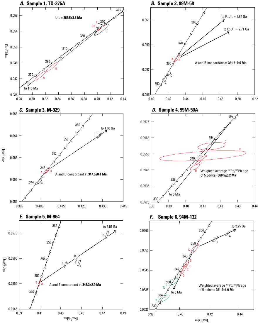
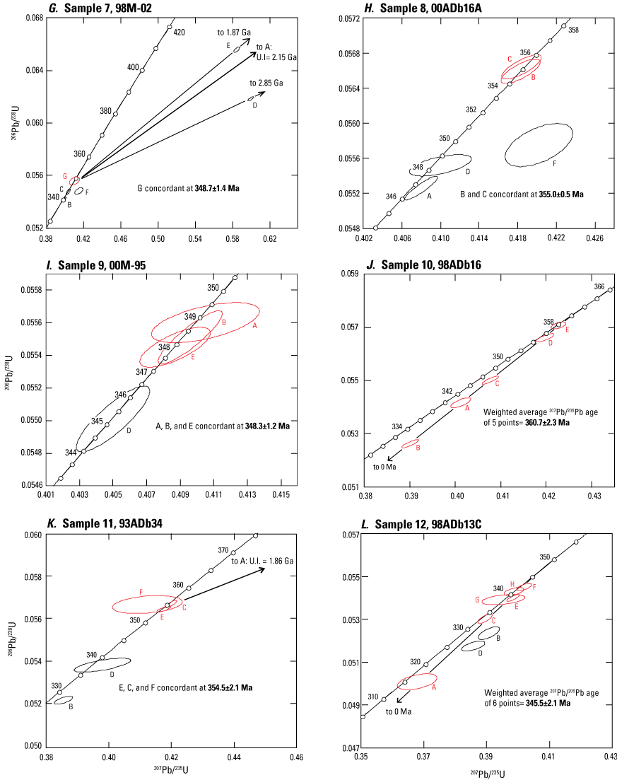
Concordia plots of thermal ionization mass spectrometry (TIMS) U-Pb analyses of zircon from Paleozoic metaigneous rocks of the Lake George (A, B) and Fortymile River assemblages (C–L), Yukon and Alaska. Error ellipses (labeled by letters) are shown for different zircon fractions; those in red were used to calculate the interpreted U-Pb age (in bold). All concordia ages in mega-annum (Ma). Locations of samples 1–12 and their interpreted ages are shown in figure 4. Green error ellipses in figure 7F denote analyses of titanite (T). Ga, giga-annum; U.I., calculated upper concordia intercept age.
A second sample of coarse potassium-feldspar augen orthogneiss from this same body was collected from a locality 22 km to the west (sample 2; fig. 4, table 2). An age of 361.8±0.6 Ma is assigned to the sample based on a weighted average 206Pb/238U age of two partially overlapping concordant analyses (fig. 7B; table 2).
Fortymile River Assemblage
Weakly to moderately foliated, medium-grained, equigranular granodiorite of the Sixtymile batholith was sampled along the Sixtymile River near the north edge of the batholith (sample 3; fig. 4, table 2). Four zircon fractions were analysed. Two of these give overlapping concordant analyses with a weighted average 206Pb/238U age of 347.5±0.4 Ma that is considered the best estimate for the crystallization age of the rock (fig. 7C; table 2).
A sample was collected from a narrow (approximately 5-m-thick) conformable band of granitic orthogneiss that contains potassium-feldspar augen as long as 3 centimeters (cm) in the longest dimension; the augen-bearing orthogneiss occurs within rocks of the Fortymile River and Finlayson assemblages, just above the Cretaceous extensional fault that separates the Fortymile River and Finlayson assemblage rocks from the underlying Lake George assemblage (sample 4; fig. 4, table 2). Rocks in this area are strongly metamorphosd to hornfels facies around several massive Late Cretaceous quartz monzonite intrusions and were previously mapped by Tempelman-Kluit (1974) as a separate rock unit comprising “chert and metachert with minor chloritic phyllite and marble” (p. 25–26). However, the rocks in the area package transition gradationally into more typical rocks of the Fortymile River assemblage away from the intrusions. Zircons recovered from the sample are similar to those in other samples of feldspar augen orthogneiss. Analyses of five fractions of strongly abraded zircons are all slightly discordant (fig. 7D). All give consistent 207Pb/206Pb ages, however, and a weighted average of these ages (360.5±3.2 Ma) is considered the best estimate for the crystallization age of the rock (table 2).
A body of moderately foliated hornblende-biotite granodioritic gneiss occurs north of the Top of the World Highway along the Alaska-Yukon border (fig. 4) within an assemblage of mafic schist, amphibolite, marble, and carbonaceous metasedimentary rocks. The supracrustal assemblage into which this body was emplaced lies near a facies change between dominantly Nasina assemblage rocks to the east and Fortymile River assemblage to the west. The orthogneiss was sampled on a mine access road (sample 5; fig. 4, table 2). Two fractions of strongly abraded zircon give overlapping concordant analyses (fig. 7E) that have a weighted average 206Pb/238U age of 348.3±2.9 Ma, which gives the crystallization age of the sample.
A large body of hornblende-biotite granodiorite orthogneiss was sampled on the west side of the Yukon River (sample 6; fig. 4, table 2). The orthogneiss is interpreted to be in thrust contact with overlying, variably carbonaceous metasedimentary rocks and marble of the Nasina assemblage to the northeast and in uncertain, but presumably intrusive, contact with rocks of the Finlayson and Snowcap? assemblages to the southwest (Gordey and Ryan, 2005, and geologic mapping by Mortensen in 1989–1993). This orthogneiss body is compositionally similar to, and may be a southeastern extension of, the Sixtymile batholith (sample 3 above), but is separated from it in map view by a large area of overlying Late Cretaceous volcanic and sedimentary rocks (fig. 4). Five zircon fractions give slightly discordant analyses (app. 4, table 4.1; table 2; fig. 7F). Four of the fractions give overlapping 207Pb/206Pb ages and a weighted average of 351.9±1.9 Ma, which we consider the best estimate for the crystallization age of the sample. Two strongly abraded fractions of euhedral, pale yellow-brown titanite from this sample were also analysed (app. 4, table 4.1; fig. 7F, T1 and T2) in an attempt to constrain the age of the deformation and metamorphism that the gneiss has experienced. The titanite fractions yield concordant but imprecise analyses between about 339 and 332 Ma, indicating either that the titanite also has experienced substantial lead loss or was newly grown during a Middle or Late Mississippian metamorphic event (our preferred interpretation).
We collected a sample of granodioritic gneiss (sample 7; fig. 4, table 2; app. 1, fig. 1.1A) from the informal unit referred to as the Steele Creek Dome tonalite or Steele Creek Dome orthogneiss by Day and others (2002) about 5 km northwest of a previously analyzed sample (sample 42, table 1) that yielded a U-Pb zircon age of 343±4 Ma (Day and others, 2002). Seven strongly abraded zircon fractions were analyzed (app. 4, table 4.1; fig. 7G), and three of these give concordant but non-overlapping analyses and appear to be free of any inherited component. Fraction G gives the oldest 206Pb/238U age at 348.7±1.4 Ma, which we consider the best estimate for the minimum crystallization age of the sample and is in agreement with the age reported by Day and others (2002).
Foliated, garnet-bearing hornblende tonalite within Fortymile River assemblage amphibolites was sampled from a small body along the Fortymile River (sample 8; fig. 4, table 2; app. 1, fig. 1.1B). Five zircon fractions were analyzed (fig. 7H; app. 4, table 4.1), and two give overlapping concordant analyses that have a weighted average 206Pb/238U age of 355.0±0.5 Ma, which we interpret to be the crystallization age of the sample.
Quartz dioritic orthogneiss that forms a conformable band approximately 100 m thick within amphibolites of the Fortymile River assemblage is exposed along the north side of the Fortymile River, approximately 6.5 km east of the Alaska-Yukon border. Four fractions of zircon recovered from a sample from this body (sample 9; fig. 4, table 2; app. 1, fig. 1.1C) were analyzed and all yield concordant analyses (table 2; fig. 7I). Three of the analyses cluster on concordia and have a weighted average 206Pb/238U age of 348.3±1.2 Ma, which we interpret as the crystallization age of the sample (table 2).
A small body of mylonitic quartz-biotite-feldspar granitic augen gneiss with coarse augen (1–4 cm in length) of pink potassium-feldspar and polycrystalline quartz was sampled along the Taylor Highway (sample 10; fig. 4, table 2; app. 1, fig. 1.1D). All local outcrops and felsenmeer in this area consist of amphibolite or quartz-biotite schist. Five fractions of zircon give slightly to moderately discordant analyses with overlapping 207Pb/206Pb ages (fig. 7J); a weighted average 207Pb/206Pb age for the five fractions is 360.7±2.3 Ma, which is our interpreted crystallization age for the sample (table 2).
A body of strongly foliated, intensely folded, and mylonitic augen gneiss containing potassium-feldspar augen (1–4 cm in length) within Fortymile River assemblage amphibolites, located south of the Taylor Highway and east of the Chicken assemblage, was sampled for dating (sample 11; fig. 4, table 2; app. 1, fig. 1.1E). Six zircon fractions were analyzed (fig. 7K; app. 4, table 4.1); three of these are concordant and have a weighted average 206Pb/238U age of 354.5±2.1 Ma, which we interpret as the crystallization age of the sample (table 2).
A narrow (approximately 1- to 2-m-thick) band of rusty-weathering muscovite and quartz-muscovite schist is interlayered with biotite quartzite of the Fortymile River assemblage on the North Fork Fortymile River (sample 12; fig. 4, table 2; app. 1, fig. 1.1F). We interpret the schist to have been derived from a felsic tuff or cherty tuff within the Fortymile River assemblage. The sample yielded both euhedral grains and rounded and pitted or frosted grains that are clearly detrital. Eight fractions were selected from the euhedral zircon population; six of these yield slightly to moderately discordant analyses that have overlapping 207Pb/206Pb ages and a weighted average of these ages is 345.5±2.1 Ma (fig. 7L). We consider this to be the best estimate for the crystallization age of the sample.
Nasina Assemblage
A total of 15 samples of metamorphosed intrusive and volcanic rocks from within the Nasina assemblage were dated to better constrain the age of this assemblage (table 2). Ten of these samples are from thin (<1 m thick) conformable layers of felsic quartz-muscovite schist, locally containing small quartz and (or) feldspar augen, within the metaclastic rocks of the Nasina assemblage. Several of these conformable samples have gradational contacts with the enclosing clastic rocks and are interpreted to have been thin felsic airfall tuff layers; however, others have sharp contacts with the enclosing metasediments and could be either tuffs or thin porphyritic flows. The remainder of the samples are from orthogneiss or augen schist units that are interpreted to be intrusions that were emplaced into the metaclastic units; their ages give minimum depositional ages for the enclosing Nasina assemblage metaclastic rocks.
U-Pb zircon ages for thin metatuffaceous units within siliceous metaclastic rocks, such as in the Nasina assemblage, must be interpreted with caution because it is common for such units to be reworked to some extent during and immediately after deposition and mixing with detrital zircons from the host metasedimentary rocks may occur. Care was taken to avoid grains with rounded or frosted surfaces that may be detrital in origin.
A sample of pale gray quartz-muscovite schist (sample 13) was collected from a band of slightly rusty, buff- to pale-gray-weathered quartz muscovite schist approximately 5 to 8 m in thickness that occurs within an outcrop of medium-gray carbonaceous Nasina assemblage on the east side of Midnight Dome 3 km east of Dawson (fig. 6). This band has gradational contacts with the surrounding carbonaceous schist and is interpreted to be a felsic metatuff that was depositionally interlayered with the carbonaceous metaclastic rocks. A direct depositional age for the Nasina assemblage rocks in this area is provided by zircons recovered from a small amount of euhedral zircon consisting of stubby, square, prismatic grains and four strongly abraded fractions were analyzed (table 2). Fraction B yields a concordant age of 358.5±1.1 Ma (fig. 8A), which we interpret as a minimum crystallization age for the tuff protolith and depositional age for the clastic rocks of the Nasina assemblage in this area. The other three fractions each give much older ages and appear to contain a substantial inherited zircon component (table 2; app. 4, table 4.1). Two-point regressions from concordant fraction B through each of the discordant fractions give calculated upper intercept ages ranging from 3.91 to 2.07 Ga, indicating a wide range of ages for the inherited zircon component.
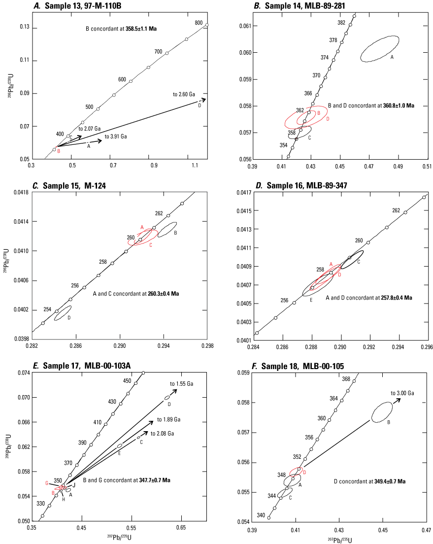
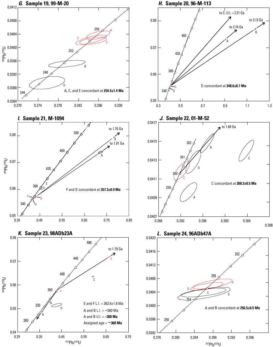
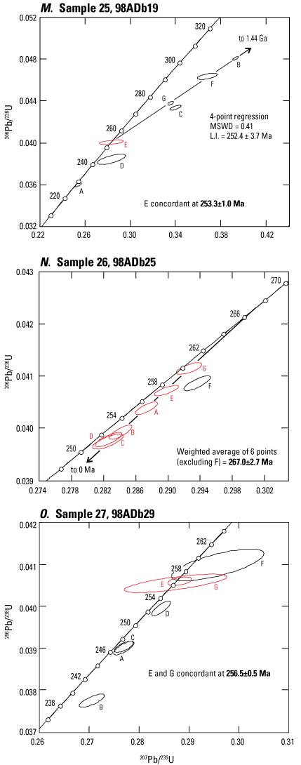
Concordia plots of thermal ionization mass spectrometry (TIMS) U-Pb analyses of zircon from Paleozoic metaigneous rocks of the Nasina assemblage, Yukon and Alaska. Error ellipses (labeled by letters) are shown for different zircon fractions; those in red were used to calculate the interpreted U-Pb age (in bold). All concordia ages in mega-annum (Ma). Locations of samples 13–27 and their interpreted ages are shown in figures 4 and 6. Ga, giga-annum; U.I., calculated upper concordia intercept age; L.I., calculated lower concordia intercept age; MSWD, mean squared weighted deviation.
Three samples of felsic schist were dated from localities within the carbonaceous Nasina assemblage along the access road to the Clinton Creek mine (fig. 6). Several small occurrences of stratiform, syngenetic sedimentary exhalative, or SEDEX-type, lead-zinc-barium mineralization occur in this general area (fig. 6) and give broadly middle Paleozoic lead isotopic model ages (Mortensen and others, 2006). Pale to dark gray, fine grained, carbonaceous quartzite and quartz-muscovite schist are well exposed along much of the Clinton Creek mine access road (fig. 6). Sample 14 was collected from a thin (approximately 5-m-thick) layer of buff to slightly rusty-weathering quartz-muscovite schist (app. 2, fig. 2.1A) interlayered with the carbonaceous metaclastic rocks. We interpret it to be a felsic metatuff that was deposited along with the clastic rocks. Most of the zircons recovered from a sample of this material are euhedral, stubby, square prismatic grains that we interpret to be derived from the igneous protolith of the metatuff unit; however, a small number of zircons display subrounded, frosted textures, indicating they are detrital grains that were incorporated into the metatuff during deposition or subsequent reworking. Two of the euhedral zircon fractions (B and D) give overlapping concordant analyses with a weighted average 206Pb/238U age of 360.8±1.0 Ma (fig. 8B), which we consider to be the crystallization age for the tuff protolith and the depositional age for the Nasina assemblage in this area. Fraction C gives a slightly younger 206Pb/238U age, reflecting minor post-crystallization lead loss, and the fourth fraction (A) gives an older age, indicating the presence of a minor inherited zircon component (table 2; app. 4, table 4.1).
Two small bodies of moderately foliated felsic metaporphyry also occur within Nasina assemblage rocks. Sample 15 (fig. 6), from a 2- to 3-m-thick band of quartz-feldspar metaporphyry that contains subhedral to euhedral feldspar and quartz augen as large as 1 cm in diameter in a very fine-grained felsic matrix (app. 2, fig. 2.1B), is exposed in a small, cleared area near the Clinton Creek mine access road. Abundant euhedral, prismatic zircon was recovered from a sample of the unit, and four fractions of strongly abraded euhedral zircon grains were analyzed. Fractions A and C give overlapping concordant analyses with a weighted average 206Pb/238U age of 260.3±0.4 Ma (fig. 8C), which gives the crystallization age of the unit. One other fraction (D) has experienced minor lead loss and another (B) contains a small amount of inherited zircon (table 2; app. 4, table 4.1). Sample 16 (fig. 6), from a fine-grained, moderately foliated quartz-muscovite schist that contains sparse quartz augen as large as 4 mm in diameter, was intersected in a diamond drill hole at one of the SEDEX-type lead-zinc occurrences (Paterson, 1982), 1.9 km north of where sample 14 of this study (interpreted to be a fine-grained felsic metatuff) was collected. Zircons recovered from sample 16 are similar to those in sample 15. Three fractions give concordant analyses (fig. 8D). Two of these (A and D) give overlapping analyses with a weighted average 206Pb/238U age of 257.8±0.4 Ma, which we interpret as the crystallization age of the sample and the unit in which it occurs. Fraction E is concordant with a slightly younger 206Pb/238U age, reflecting minor lead loss (app. 4, table 4.1). Fraction C contains a minor older inherited zircon component and fraction B (not shown on fig. 8D) contains a much larger inherited component (table 2).
Two samples of felsic metaigneous rock within non-carbonaceous Nasina assemblage schists were dated from localities on the Yukon River upstream from the Alaska-Yukon border (fig. 6). Sample 17 is from a rusty-weathered muscovite-quartz schist that occurs as a 2- to 3-m-thick band within brown-weathering quartz-muscovite schist, minor quartzite, and rare marble, approximately 51 km upstream from the border. We tentatively interpret this sample as a felsic metatuff. Zircons recovered from the sample consist mainly of pale pink, subhedral grains, some of which have smoothly rounded surfaces that are thought to result from magmatic resorption. Eight fractions of zircon were analyzed (app. 4, table 4.1). Two of these (B and G) give overlapping concordant analyses with a weighted average 206Pb/238U age of 347.7±0.7 Ma (fig. 8E), which is interpreted as the crystallization age of the sample. Three other analyses (A, H, and J) are slightly discordant and give slightly younger U-Pb ages. Three fractions (C, D, and E) yield strongly discordant analyses (fig. 8E) and regressions through the two concordant analyses and each of these single analyses give calculated upper intercept ages ranging from 2.08 to 1.55 Ga, indicating a range of Paleoproterozoic to Mesoproterozoic inherited zircon components were present in each of these fractions (app. 4, table 4.1).
A second sample from along the Yukon River (sample 18) is from a 4- to 5-m-thick band of pale- to medium-green-weathering quartz-muscovite-chlorite schist that contains small, scattered quartz eyes. The schist occurs within a separate structural slice of non-carbonaceous Nasina assemblage schist approximately 36 km upstream from the Alaska-Yukon border (fig. 6). This rock unit could be either a metamorphosed crystal tuff or a fine-grained metaporphyry. Zircons recovered from the sample consist of euhedral, stubby, square, prismatic grains. Four zircon fractions were analyzed (app. 4, table 4.1). Three of these yield non-overlapping concordant analyses, interpreted to reflect variable post-crystallization lead-loss effects that were not completely removed by air abrasion. The oldest concordant fraction (D) has a 206Pb/238U age of 349.4±0.7 Ma, which we interpret as a minimum crystallization age for the rock unit. One zircon fraction (B) gives a strongly discordant analysis, and a regression through this analysis and that of fraction D yields a calculated upper intercept age of 3.00 Ga, indicating the presence of Neoarchean inherited zircon components in this sample (fig. 8F).
Another sample (19) was collected along the Top of the World Highway 29 km northwest of Dawson (fig. 6). The sample comes from a thin layer of felsic schist that occurs within medium gray, moderately carbonaceous Nasina assemblage quartz-muscovite schist and minor marble, immediately above a thrust contact that emplaces Nasina assemblage over Permian Klondike assemblage rocks. The layer is approximately 3 m thick and displays gradational contacts with the enclosing Nasina assemblage schists. We interpret the unit to be a felsic tuff that was depositionally interlayered with the Nasina assemblage metaclastic rocks. A moderate amount of zircon was recovered from sample 19, and comprises mainly fine, subhedral to euhedral grains. Five strongly abraded multigrain fractions were analyzed (app. 4, table 4.1) and all give concordant analyses. Three of these (fractions A, C, and E) form a cluster of overlapping analyses with a weighted average 206Pb/238U age of 254.5±1.4 Ma (fig. 8G), which we interpret as the best estimate for the age of the sample. Two other fractions give somewhat younger 206Pb/238U ages, reflecting minor post-crystallization lead loss.
Medium to dark gray, carbonaceous quartz-muscovite schist that contains rare interlayers of gray fine-grained quartzite, marble, and chlorite schist occurs in an east-west-trending, south-dipping band that crosses the Yukon River at Dawson and underlies the Klondike River valley to the east (fig. 4). It is bounded to the north and south (structurally below and above, respectively) by felsic schists of the Permian Klondike assemblage. The Nasina assemblage package in this area is structurally imbricated, and both internal and bounding thrust faults are marked by thin to very thick lenses of massive greenstone and variably sheared serpentinized ultramafic rocks (fig. 4). Zircons recovered from a leucogabbro dike that intrudes serpentinized peridotite southwest of Midnight Dome yield a U-Pb crystallization age of 264±4 Ma (fig. 4, sample 73; van Staal and others, 2018). Because the ultramafic rocks are in fault contact with the Nasina assemblage, this age does not directly constrain that of the Nasina assemblage.
We collected a sample from an approximately 10-m-thick layer of hornblende-biotite granodioritic gneiss that is parallel to compositional layering in carbonaceous Nasina assemblage metaclastic rocks with minor marble on the west shore of the Yukon River, just across from Dawson (sample 20; figs. 4, 6). Zircons from the granodioritic gneiss display complex U-Pb systematics (fig. 8H). One strongly abraded fraction (D) gives a concordant 206Pb/238U age of 348.6±0.7 Ma, which we interpret as a minimum crystallization age for the intrusive protolith of this sample. Fraction E gives a slightly younger 206Pb/238U age of 344.5±1.0 Ma, probably reflecting minor post-crystallization lead loss that was not completely removed by abrasion. Three other multigrain zircon fractions (A, B, and C) give a range of much older ages, indicating the presence of abundant inherited zircon cores (app. 4, table 4.1). Two-point chords through each of these discordant fractions and concordant fraction D give calculated upper intercept ages ranging from 3.13 to 2.31 Ga, indicating a range of Neoarchean to Paleoproterozoic ages for the inherited zircon component (fig. 8H).
Sample 21 (figs. 4, 6) is from a conformable body of granodioritic gneiss at least 20 m thick that intrudes carbonaceous Nasina assemblage metaclastic rocks and minor chlorite schist interlayers; it was sampled from an outcrop on the Yukon River about 36 km downstream from Dawson. The gneiss unit contains subhedral to strongly flattened potassium-feldspar augen as large as 2 cm in diameter. Abundant zircon was recovered from a sample of this unit that comprises mainly medium- to coarse-grained, euhedral, stubby prismatic grains with no visible cores. Six strongly abraded multigrain zircon fractions were analyzed (app. 4, table 4.1). Two of these (F and G) give overlapping concordant analyses with a weighted average 206Pb/238U age of 357.3±0.9 Ma (fig. 8I), which we interpret as the crystallization age of the unit. Fraction H gives a slightly younger age, reflecting lead loss, and four other fractions (A, B, D, and E; D and E plot outside of fig. 8I) give slightly to strongly discordant analyses that yield older U-Pb and Pb-Pb ages, indicating that inherited zircon cores were present in at least some of the grains in each fraction. Two-point regressions through the two concordant fractions and each of the two strongly discordant fractions give calculated upper intercept ages of 1.91 and 1.70 Ga (fig. 8I), indicating that the age of the inherited zircon component was predominantly Paleoproterozoic.
A large body of biotite orthogneiss that contains sparse potassium-feldspar augen intrudes carbonaceous Nasina assemblage schist and quartzite near the south edge of the Klondike district (figs. 4, 6). Sample 22, collected from this body, yielded abundant, clear, euhedral, prismatic zircon grains. Five strongly abraded fractions were analyzed (app. 4, table 4.1; fig. 8J). Fraction C is concordant with a 206Pb/238U age of 260.2±0.5 Ma. We interpret this as a minimum crystallization age for the sample. Fraction C, together with two other fractions (B and D) that give slightly older ages, define a three-point chord with a calculated upper intercept age of 1.69 Ga, indicating that a Mesoproterozoic inherited zircon component is present in these two discordant fractions (fig. 8J). Two other zircon fractions (A and E) fall below this regression line, and likely reflect a combination of inheritance and post-crystallization lead loss.
Zircon samples were collected from Nasina assemblage metarhyolite at five localities in the eastern Eagle quadrangle; sample 23 is from felsic metatuff within the non-carbonaceous facies of the Nasina assemblage and samples 24–27 are from the carbonaceous facies of the Nasina assemblage (figs. 4, 6). Sample 23 was collected from blocks derived from a layer of slightly rusty-weathered quartz-muscovite schist (app. 2, fig. 2.1C) in a borrow pit along the Taylor Highway. The sample yielded a small amount of pale pink, euhedral, stubby, prismatic zircon grains. Six strongly abraded multigrain fractions were analyzed (app. 4, table 4.1). None of the analyses is concordant (fig. 8K). Fractions A and B give identical 207Pb/206Pb ages with a weighted average of 360±11 Ma. We interpret this as an approximate depositional age for the sample. The other four analyses give variably discordant analyses (fig. 8K), indicating the presence of minor older inherited zircon components. Two of the analyses form a discordia line with a lower intercept of approximately 360 Ma, similar to the interpreted depositional age, and an upper intercept of 1.79 Ga, indicating a Paleoproterozoic average age for at least some of the inherited zircon components.
Metarhyolite sample 24 has a weakly developed foliation and contains quartz and feldspar phenocrysts (app. 2, fig. 2.1D); it was collected from rubble along the Taylor Highway within the carbonaceous Nasina assemblage. A moderate amount of pink to pale yellow, stubby to elongate, euhedral zircons were recovered from the sample and four strongly abraded fractions were analyzed (app. 4, table 4.1). All fractions give concordant analyses (fig. 8L). Two of these (A and B) give overlapping 206Pb/238U ages with a weighted average of 256.5±0.5 Ma, which we interpret as the depositional age of the sample. Two other fractions give slightly younger 206Pb/238U ages, reflecting very minor lead-loss effects that were not completely avoided by air abrasion of the zircons.
Sample 25 is a fine-grained metarhyolite containing rotated feldspar and strained quartz phenocrysts (app. 2, fig. 2.1E) that was collected along the Taylor Highway from a felsic block within the carbonaceous Nasina assemblage unit. Six strongly abraded fractions of stubby, euhedral, prismatic zircons were analyzed. One of these (E) gives a concordant analysis with a 206Pb/238U age of 253.3±1.0 Ma (fig. 8M). We interpret this as a minimum crystallization age for the sample (table 2). The other analyses are very slightly to strongly discordant, indicating the presence of older inherited zircon components. Three of the analyses (B, F, and G), together with concordant fraction E, define a discordia line with a calculated upper intercept age of 1.44 Ga, indicating a Mesoproterozoic age for some of the inherited zircon components (fig. 8M).
Metarhyolite sample 26 has wavy crenulation cleavage containing thin folia of white quartz and rounded augen of white quartz and orange, iron-stained feldspar (app. 2, fig. 2.1F). The felsic metarhyolite has sparce, scattered dark, chip-like patches <1.5 cm in length composed of quartz and a dark mineral (graphite?) that likely were derived from graphitic quartz layers above and below the approximately 20- to 30-m-thick felsic metavolcanic layer. Folding may have thickened the metarhyolite layer, consistent with the folding observed at mesoscopic and microscopic scales. Sample 26 yielded a distinctly bimodal zircon concentrate, with approximately half of the recovered grains forming clear, colorless to pale pink, stubby, euhedral prismatic grains and the rest occurring as rounded, frosted pinkish grains that are clearly detrital. Seven fractions of the euhedral population were analyzed after strong abrasion (app. 4, table 4.1). None of the analyses is concordant; however, six of them range from 2.6 to 4.9 percent discordant and give overlapping 207Pb/206Pb ages with a weighted average of 267.0±2.7 Ma (fig. 8N). We consider this to be a reasonable estimate for the crystallization age of the euhedral zircon component in the sample. One of the fractions gives a slightly older 207Pb/206Pb age and appears to contain a minor older inherited zircon component (table 2).
Sample 27 was collected from an outcrop of metarhyolite along King Solomon Creek, just west of the Taylor Highway (fig. 6). The sample is a mylonitized metarhyolite with rotated and rounded quartz and feldspar phenocrysts in a fine-grained matrix of quartz and sericite (app. 2, fig. 2.1G). The sample yielded a small amount of pale pink, euhedral, stubby, prismatic zircon grains. Seven strongly abraded fractions were analysed (app. 4, table 4.2). Two of these fractions (E and G) give overlapping 206Pb/238U ages that have a weighted average of 256.5±0.5 Ma (fig. 8O), which we interpret as the best estimate for the crystallization age of the sample. All the other fractions give slightly older 207Pb/206Pb ages, indicating both minor inheritance of older inherited zircon components and variable effects of post-crystallization lead loss.
Ladue River Unit
A body of biotite orthogneiss, locally retrograded to greenschist facies, that contains scattered potassium-feldspar and quartz augen (<2 cm in length) was sampled in the east-central part of the Tanacross quadrangle (sample 28, fig. 4, table 2; app. 3, fig. 3.1A). Only a small amount of zircon was recovered, and most of the coarser grains contain visible cloudy inherited cores. Clear tips were broken from grains with visible cores, and then strongly abraded. Three of the resulting fractions yield concordant analyses (fig. 9A; table 2; app. 4, table 4.1). The oldest of these gives a 206Pb/238U age of 362.9±1.4 Ma, which we interpret as the minimum crystallization age of the sample.
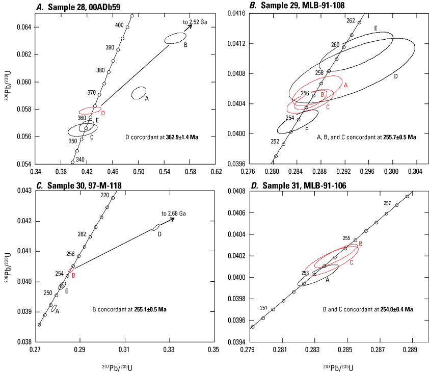
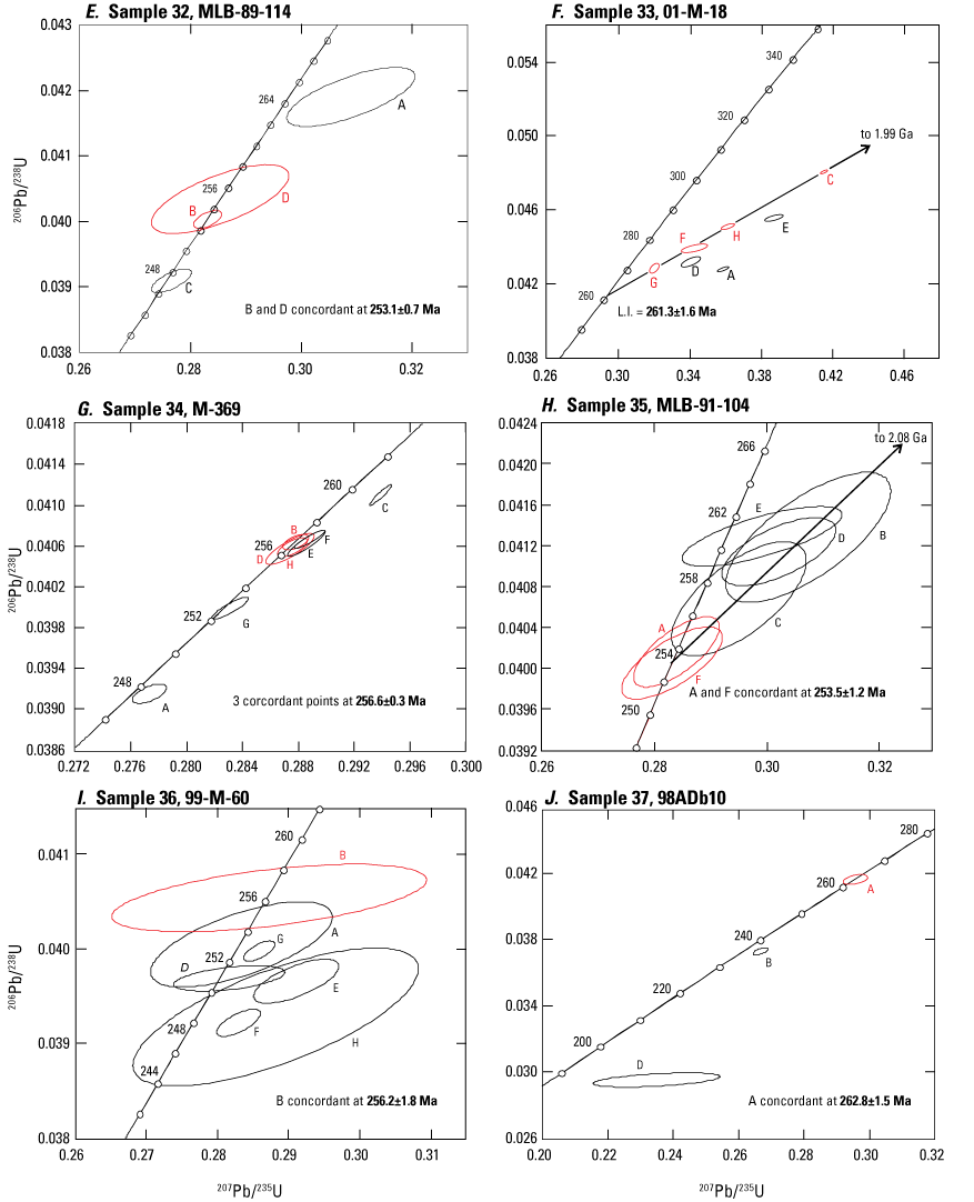
Concordia plots of thermal ionization mass spectrometry (TIMS) U-Pb analyses of zircon from Paleozoic metaigneous rocks of the Ladue River unit (A), Klondike assemblage (B–I), and a dike intruding the Fortymile River assemblage (J), Yukon and Alaska. Error ellispses (labeled by letters) are shown for different zircon fractions; those in red were used to calculate the interpreted U-Pb age (in bold). All concordia ages in mega-annum (Ma). Locations of samples 28–37 and their interpreted ages are shown in figure 4. Ga, giga-annum; L.I., calculated lower concordia intercept age.
Klondike Assemblage
Nine separate samples of metavolcanic and meta-intrusive rocks mapped as the Klondike assemblage were collected for U-Pb dating in this study. Six of these are from layers of rusty-weathered, pyritic and locally baritic, muscovite and quartz-muscovite schist that are interpreted to be extrusive (probably tuffaceous) in origin. Three samples are quartz-muscovite (±chlorite) schist that contain abundant subhedral quartz and (or) feldspar augen and are interpreted to have been crystal-rich flows or subvolcanic sills. Most zircons recovered from Klondike assemblage samples contain abundant clear bubble- and tube-shaped inclusions and many show evidence of magmatic resorption of zircon prior to final crystallization of the magma. Many of the zircon fractions analysed contain a high proportion of common lead (presumably from the abundant inclusions) and some analyses are therefore somewhat imprecise.
Very fine-grained, rusty-weathered, quartz-muscovite schist was collected from an approximately 10-m-thick band exposed in a roadcut on the Top of the World Highway 17 km west of Dawson (sample 29; fig. 4, table 2; app. 3, fig. 3.1B). The sample contains fine, clear, resorbed quartz eyes and minor barite. This is one of several bands of felsic schist in the vicinity that are interlayered with tan- to pale-brown-weathering quartz-muscovite-chlorite schist of probable sedimentary or volcaniclastic origin, as well as chloritic schist (probable mafic metavolcanic protolith) and narrow conformable bodies of metadiabase and metagabbro. Six fractions were analysed; all analyses are concordant or nearly so (app. 4, table 4.1; fig. 9B). The best estimate for the crystallization age for this sample is given by the total range of 206Pb/238U ages of 255.7±0.5 Ma for three fractions with overlapping concordant analyses.
A second felsic metatuff sample consisting of rusty-weathered, variably pyritic muscovite schist was collected from another roadcut on the Top of the World Highway 12 km east of sample 29 (sample 30; fig. 4, table 2). Five fractions were analysed (fig. 9C; app. 4, table 4.1), one of which is concordant with a 206Pb/238U age of 255.1±0.5 Ma, interpreted as the minimum crystallization age for the sample (table 2). Fractions A and E have suffered post-crystallization lead-loss and fractions C (not shown on fig. 9C) and D contain substantial components of inherited lead.
A conformable layer approximately 4 m thick of blocky-weathering, weakly to moderately foliated, fine-grained, quartz-muscovite schist with abundant quartz and potassium-feldspar augen as large as 3 mm in diameter occurs within more typical fine-grained, tan to pale gray-green quartz-muscovite schist of the Klondike assemblage along the Top of the World Highway (sample 31; fig. 4, table 2). This unit likely originated as a porphyritic sill. Three fractions were analysed (fig. 9D; app. 4, table 4.1), and all analyses are concordant. Two of these give overlapping analyses with a weighted average 206Pb/238U age of 254.0±0.4 Ma, which is interpreted as the crystallization age of the sample.
Another felsic metatuff was sampled in the northeastern part of the Klondike district (sample 32; fig. 4, table 2). The sample is from a band of rusty-weathering muscovite and quartz-muscovite schist that is interlayered with a sequence of non-carbonaceous, tan-weathering micaceous quartzite. Four fractions of zircon were analysed (fig. 9E; app. 4, table 4.1), two of which fall on or near concordia at about 255 Ma. The best age estimate is given by the weighted average 206Pb/238U age for these two fractions at 253.1±0.7 Ma (table 2).
An outcrop of very rusty-weathered, pyritic muscovite-quartz schist (felsic metavolcanic protolith) was sampled in the central part of the Klondike district (sample 33; fig. 4, table 2). Eight zircon fractions were analyzed (fig. 9F; app. 4, table 4.1); however, none of the analyses is concordant. Four of the analyses are moderately discordant and define a linear array (MSWD=0.70) with calculated lower and upper intercept ages of 261.3±1.6 Ma and 1.99 Ga, respectively (fig. 9F). One fraction (not shown in fig. 9F) is highly discordant but falls close to this regression line. Three of the fractions (A, D, and E) analyzed plot below the line, probably reflecting minor lead loss that was not completely removed by the abrasion process. We interpret the calculated lower intercept as the best estimate for the age of the sample.
A sample of felsic augen schist, which is interpreted to be a deformed and metamorphosed porphyry, was collected from a large outcrop west of an access road into the headwaters of Moose Creek in the southwestern Dawson map area (sample 34; fig. 4, table 2). This unit occurs within a thrust-fault-bounded sequence of felsic metavolcanic rocks in the northern part of the Sixtymile district. The sample is from a conformable band of augen schist approximately 3 m thick. It consists of subhedral to euhedral potassium-feldspar augen as large as 1 cm in diameter in a matrix of moderately to strongly foliated quartz-muscovite (±chlorite) schist. The surfaces of some of the grains recovered from the sample show evidence of magmatic resorption. Eight fractions were analysed (fig. 9G; app. 4, table 4.1). Three of these give overlapping concordant analyses with a weighted average 206Pb/238U age of 256.6±0.3 Ma, which is the best estimate for the crystallization age of the unit (table 2).
Another metaporphyry body (sample 35; fig. 4, table 2) is from a fine-grained, approximately 5-m-thick layer of quartz-augen-bearing quartz-muscovite schist within a thick package of felsic schists in the northwestern Stewart River map area. Six fractions were analysed (fig. 9H; app. 4, table 4.1), and all contained high levels of common lead, presumably related to abundant inclusions in most of the zircons. Two fractions give overlapping concordant analyses that have a weighted average 206Pb/238U age of 253.5±1.2 Ma, which we interpret as the crystallization age of the sample.
Sample 36 (fig. 4, table 2) is from an outcrop in the southern Sixtymile district, south of the Sixtymile River. It is from a body of rusty quartz-muscovite schist that is interpreted to form a window through a thrust fault that places rocks of the Finlayson assemblage (or Fortymile River assemblage) above felsic schists of the Klondike assemblage. Only a small amount of poor-quality zircon was recovered from this sample. The zircons in this sample are mainly euhedral, but all contain abundant clear inclusions. Seven fractions of strongly abraded zircons were analyzed (fig. 9I; app. 4, table 4.1), and four of these yield concordant, although imprecise, analyses. The 206Pb/238U age of the oldest concordant analysis (B), at 256.2±1.8 Ma, is tentatively considered a reasonable estimate of the minimum crystallization age of the rock unit (table 2).
An undeformed biotite-muscovite plagioclase-phyric granodiorite dike (sample 37; fig. 4, table 2) was collected from a 30-cm-thick body that appears to cut a package of biotite quartzite and minor interlayered marble and rusty-weathering metasedimentary rocks of the foliated Fortymile River assemblage. The location is approximately 6.5 km upstream from the Taylor Highway bridge over the Fortymile River. The dike has a porphyritic texture formed by 2-mm-long plagioclase phenocrysts within a fine-grained matrix of biotite, muscovite, and quartz (app. 3, fig. 3.1C). Three fractions of strongly abraded zircons were analyzed; two of these are single grains and fraction D consists of two grains. The analyses fall on or below concordia between approximately 262 and 200 Ma (fig. 9J; app. 4, table 4.1). Single-grain fraction A is concordant at 262.8±1.5 Ma (fig. 9J), which we tentatively interpret as the minimum crystallization age of the sample. The analyses from the other two fractions appear to mainly indicate the effects of post-crystallization lead loss. These results are puzzling, because emplacement of the dike appears to have been post-tectonic, and igneous rock units elsewhere in the Nasina and Fortymile River assemblages that yield middle and late Permian crystallization ages have experienced the same high degree of strain as the enclosing rock units. Sample 37 may be analogous to a sample from a granitic pluton approximately 34 km farther west for which Jones and others (2017b) reported a U-Pb zircon age of approximately 257 Ma; Jones and others (2017b) interpreted the granitic pluton to crosscut the main foliation in Fortymile River assemblage host rocks.
Chicken Assemblage
We separated zircon from a body of moderately foliated plutonic rock of tonalitic composition located in a roadcut on the Taylor Highway approximately 4 km east of the village of Chicken (sample 38; fig. 4, table 2, app. 4, table 4.2). This body is in apparent intrusive contact with weakly foliated mafic metavolcanic rocks of the Chicken assemblage. Zircons from the sample are euhedral and have no visible inherited cores. LA-ICP-MS analyses were carried out on 20 grains and the results are shown in figure 10A. Eighteen of the grains give overlapping concordant analyses that have a weighted average 206Pb/238U age of 319.4±1.1 Ma, which we interpret to be the crystallization age of the sample. Two grains give slightly older concordant ages, and we interpret the grains to be xenocrysts.
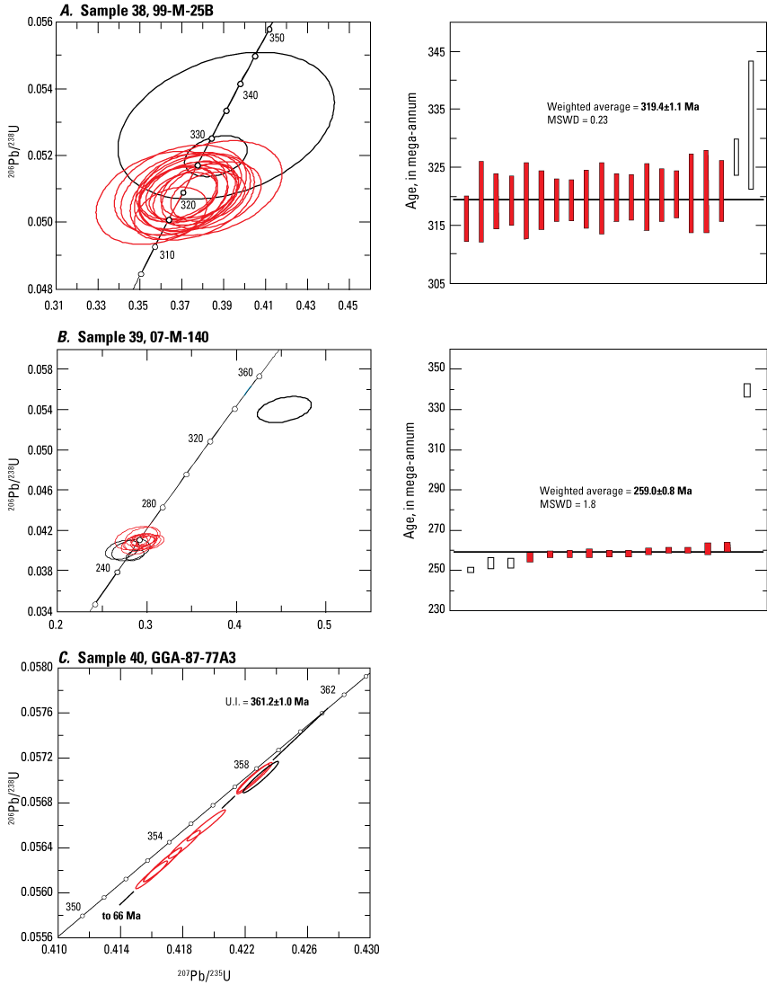
Concordia plots of laser ablation inductively coupled plasma mass spectrometry (LA-ICP-MS) U-Pb analyses of zircon from Paleozoic metaigneous rocks of the Chicken assemblage (A) and Seventymile terrane (B), and thermal ionization mass spectrometry (TIMS) U-Pb analyses of zircon from a sample of the Cassiar terrane (C), Alaska. Error ellipses (left column) and error bars (right column) are shown for different zircon fractions; those in red were used to calculate the interpreted U-Pb age (in bold). All concordia ages in mega-annum (Ma). Locations of samples 38 and 39 and their interpreted ages are shown in figure 4; the location of sample 40 is shown by the star labeled “C” in figure 1. U.I. = calculated upper concordia intercept age; MSWD, mean squared weighted deviation.
Seventymile Terrane
Zircons recovered from metamorphosed silicified tuff sample 39 (app. 3, fig. 3.1D), which crops out along the Taylor Highway north of latitude 64°30′ (fig. 4), are small, euhedral, stubby prismatic grains. Fifteen grains were analyzed by LA-ICP-MS methods (app. 4, table 4.2). All but one of the grains yield concordant analyses (fig. 10B). Eleven of these yield a tight cluster on concordia with a weighted average 206Pb/238U age of 259.0±0.8 Ma (fig. 10B, right column), which is interpreted to be the crystallization age of the rock. Three analyses give slightly younger ages, reflecting minor post-crystallization lead loss, and one analysis gives an older and strongly discordant age, which we interpret to be from a xenocryst in the sample.
Cassiar Terrane
Alkaline and peralkaline volcanic rocks and associated syenitic intrusions in the Cassiar terrane (fig. 1) are interpreted to have erupted during early stages of rifting that led to the opening of the Slide Mountain Ocean back-arc basin (for example, Mortensen, 1982). Medium- to coarse-grained quartz syenite from a large body of the syenite (sample 40) was sampled approximately 53 km due south of the village of Ross River (fig. 1) for U-Pb dating (locality C on fig. 1). Abundant coarse, stubby, pink zircons were recovered from the sample. Three strongly abraded fractions were analyzed along with four unabraded fractions (app. 4, table 4.1). The analyses form a linear array with discordance ranging from 0.8 to 2.0 percent. Three fractions cluster together at the upper end of this array; two overlap completely but the third analysis falls slightly to the right of the others, indicating a possible inherited zircon component. A regression through six analyses, omitting the rightmost analysis, gives calculated upper and lower intercept ages of 361.2 ±1.0 Ma and approximately 66 Ma, respectively (fig. 10C). We interpret the upper intercept age to be the best estimate for the emplacement age of the syenite body.
Geochemistry
Strategy
The goals of the geochemical study were to (1) establish the primary compositions of metaigneous rocks in the various lithotectonic assemblages in the study area; (2) compare and contrast the compositions and compositional range of metaigneous rock units in the different assemblages to test possible correlations between them; and (3) constrain the paleotectonic setting in which the various metaigneous suites were generated in order to better understand the overall tectonic evolution of this part of the northern Canadian and Alaskan Cordillera. We discuss our results from whole-rock geochemical samples collected during our geochronologic study (figs. 11, 12) and then compare our results to data from previously published geochemical studies by other workers for the various assemblages and lithologies under consideration (figs. 13–15) (Dusel-Bacon and Aleinikoff, 1985; Dusel-Bacon and Cooper, 1999; Szumigala and others, 2002; Dusel-Bacon and others, 2004; Piercey and others, 2006; Ruks and others, 2006; Wypych and others, 2017, 2018, 2019b; Ryan and others, 2018; Mortensen and others, 2019). Geochemical data we consider from Dusel-Bacon and Aleinikoff (1985) and Dusel-Bacon and Cooper (1999) are available in an associated data release by Dusel-Bacon and Mortensen (2023). We use geochemistry to not only more completely characterize the various assemblages, but also to provide geochemical trace-element data that can be used, in addition to U-Pb geochronology, to evaluate possible correlations of similar geologic assemblages that have been assigned to different assemblages on either side of the Alaska-Yukon border. Geochemical data are given in tables 3 and 4 and by Granitto and others (2019a, b).
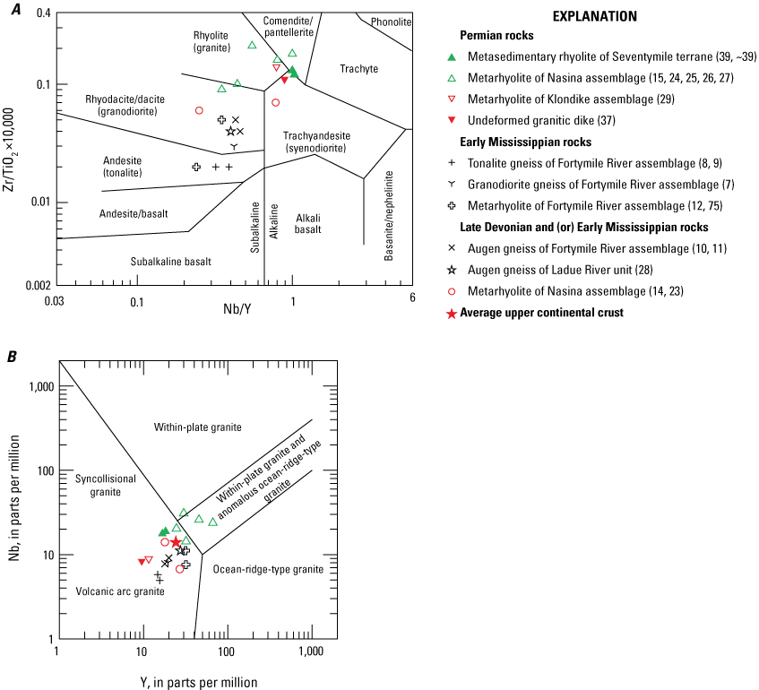
Whole-rock geochemical plots of Late Devonian, Early Mississippian, and Permian felsic metaigneous rocks from the study area in western Yukon and eastern Alaska. Geochemical data for samples from this study and U-Pb zircon sample number, age, and field number are given in tables 3 and 4. Numbers in parentheses are sample numbers (shown in figs. 4, 6). A, Zr/TiO2 versus Nb/Y discrimination diagram of Winchester and Floyd (1977). B, Niobium versus yttrium diagram of Pearce and others (1984). Average upper continental crust values from McLennan (2001).
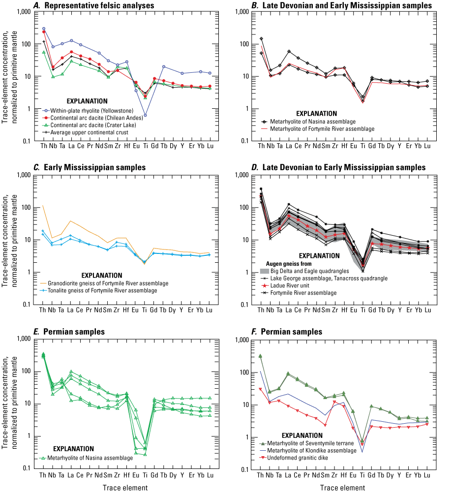
Whole-rock trace-element plots of Late Devonian to Mississippian, Mississippian, and Permian felsic igneous rocks from the study area in western Yukon and eastern Alaska. Representative felsic magmas from plate interiors and continental arcs are also shown. All concentrations are normalized to primitive mantle (Sun and McDonough, 1989). Elements are arranged in order of decreasing incompatibility during mantle melting. A, Average or representative trace-element compositions of characteristic felsic magma types from known environments: (1) Yellowstone rhyolite is the average of three intracaldera flows (76.9 percent SiO2) from the Yellowstone Plateau volcanic field, representing one of the world's largest silicic volcanic centers, in a within-plate continental setting (Hildreth and others, 1991); (2) central Andes (Chile) dacite is the average of two Pliocene Atana ignimbrite pumice samples (Lari-96h-6 x-rich and Quis-96h-9 x-rich; 67.1 percent SiO2) that erupted through 70- to 80-kilometer-thick crust in a continental arc setting (Lindsay and others, 2001); (3) Crater Lake, Oregon, dacite, represents the average pumice (70.4 percent SiO2) from the Holocene climactic eruption of Mount Mazama through approximately 40-kilometer-thick crust of Paleozoic to Tertiary accreted terranes in a continental arc setting (sample Avg 3 CIP from Bacon and Druitt, 1988). Average upper continental crust values from McLennan (2001). B–F, Rocks from this study. For comparative purposes, part D also plots Lake George assemblage augen gneiss samples from the northeastern Tanacross quadrangle; augen gneiss from the Big Delta and Eagle quadrangles in Alaska are shown by the gray area (fig. 3; Dusel-Bacon and Aleinikoff, 1985; app. 5, table 5.1).
Because of the possibility of major-element mobility (especially of alkalis) and silicification, we identified the igneous protoliths of our samples using the Zr/TiO2 versus Nb/Y diagram of Winchester and Floyd (1977), in which the Zr/TiO2 ratio serves as a fractionation index and the Nb/Y ratio serves as an alkalinity index (fig. 11A). We also utilize the niobium versus yttrium, or in one case the comparable tantalum versus ytterbium, discrimination diagram of Pearce and others (1984) (figs. 11B, 13–15) to characterize the felsic gneiss, metavolcanic, and less abundant intermediate-composition metaigneous rock samples from the study area, as well as middle and late Paleozoic felsic and intermediate metaigneous rocks from the surrounding area. These diagrams have been shown to be effective in distinguishing arc rocks (volcanic arc and syncollisional granitic arc) from non-arc rocks (within-plate and ocean-ridge-type granite) from different tectonic settings (for example, Piercey and others, 2001). Primitive-mantle-normalized multielement plots (fig. 12) of the felsic and intermediate-composition metaigneous rocks from our study provide information about magma sources and allow visual comparison of sample groups to one another and to representative samples from known tectonic settings. However, we recognize that discrimination diagrams and multielement plots of felsic igneous rocks in particular can be problematic in their interpretation because (1) possible blending of partial melt contributions from different continental lithologies can occur (for example, Piercey and others, 2001); (2) arc-like signatures can be acquired through magma generation by partial melting of or contamination by typical continental crust, which generally has a volcanic-arc signature; and (3) abundances of some high field strength elements (HFSE) (including Ti, Zr, and Hf) and rare earth elements (REE) in felsic rocks are extremely sensitive to accessory mineral fractionation and removal from the melt. For these reasons, we also consider the less ambiguous implications of the geochemistry of mafic metaigneous rocks that are associated with the felsic metaigneous rocks for the entire study area and use the thorium-halfnium-niobium discrimination diagram of Wood (1980), designed to distinguish midocean ridge basalt (MORB) from ocean island basalt (generally associated with extension) and destructive plate-margin basalts (arc basalts; generally associated with contraction), to evaluate the magmatic environments in which those rocks were generated (figs. 13, 15).
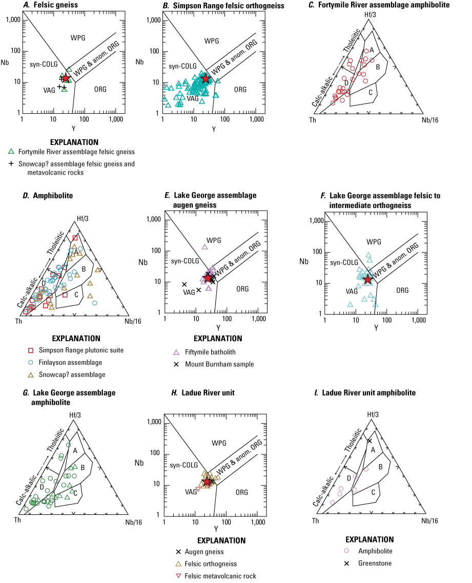
Whole-rock geochemical plots (in parts per million) of Late Devonian and Early Mississippian metaigneous rocks from the study area in western Yukon and eastern Alaska published in other studies. Niobium versus yttrium diagrams (A, B, E, F, H) of Pearce and others (1984) separate volcanic arc granites (VAG), syncollisional granites (syn-COLG), within-plate granites (WPG), and ocean-ridge-type granites (ORG); where WPG and anomalous ORG overlap is also labeled. Average upper continental crust values (red star) from McLennan (2001). Thorium-halfnium-niobium diagrams (C, D, G, I) of Wood (1980) separate normal midocean ridge basalt (area A), enriched midocean ridge basalt (area B), ocean island basalt (area C), and volcanic arc basalts (area D). A, Fortymile River assemblage data from Wypych and others (2017, 2018); Snowcap? assemblage data from Ryan and others (2018). B, Data from Ryan and others (2018). C, Data from Dusel-Bacon and Cooper (1999; app. 5, table 5.3) and Wypych and others (2017, 2018). D, Data from Ryan and others (2018). E, Fiftymile batholith data from Dusel-Bacon and Aleinikoff (1985; app. 5, table 5.1), Ryan and others (2018), and Wypych and others (2019b); Mount Burnham samples from Ryan and others (2018). F, Data from Wypych and others (2017, 2018, 2019b). G, Data plotted as circles from Wypych and others (2017, 2018, 2019b); data plotted as triangles from Dusel-Bacon and Cooper (1999; app. 5, table 5.3). H, Data from Wypych and others (2019b). I, Data from Dusel-Bacon and others (2006; “x” symbol shows greenstone sample 00ADb68A; table 3) and Wypych and others (2019b).
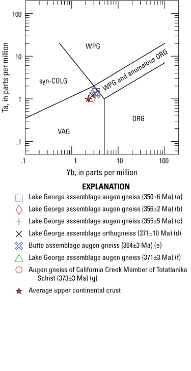
Whole-rock tantalum versus ytterbium plot (Pearce and others, 1984) of Late Devonian and Early Mississippian augen gneiss and one orthogneiss from the Lake George assemblage and correlative units from east-central Alaska. Plot separates volcanic arc granites (VAG), syncollisional granites (syn-COLG), within-plate granites (WPG), and ocean-ridge-type granites (ORG); where WPG and anomalous ORG overlap is also labeled. Average upper continental crust values from McLennan (2001). Letters after rock descriptions in the explanation correspond to sample numbers, locations, and references as follows: (a) sample 79AFr4015 from Tanacross quadrangle (Dusel-Bacon and Williams, 2009; app. 5, table 5.1); (b) sample 81ADb14C from Tanacross quadrangle (Dusel-Bacon and Aleinikoff, 1996; app. 5, table 5.1); (c) sample 17AW017 from Tanacross quadrangle (Wypych and others, 2017; Todd and others, 2019); (d) sample 17JEA001 from Tanacross quadrangle (Todd and others, 2019; sample 17JEA001 of Wypych and others, 2017); (e) sample 96ADb24 from Big Delta quadrangle (Dusel-Bacon and others, 2004; Granitto and others, 2019a, b); (f) sample 78AFrAG5 from Big Delta quadrangle (app. 5, table 5.1; Dusel-Bacon and others, 2004); (g) sample 96ADb5 from Healy quadrangle (Dusel-Bacon and others, 2004; Granitto and others, 2019a60, b).
Whole-rock geochemical plots of Permian metaigneous rocks analyzed by others from outside our study area. Niobium versus yttrium diagrams (A, B) of Pearce and others (1984) separate volcanic arc granites (VAG), syncollisional granites (syn-COLG), within-plate granites (WPG), and ocean-ridge-type granites (ORG); where WPG and anomalous ORG overlap is also labeled. Average upper continental crust values (red star in part B) from McLennan (2001). Thorium-halfnium-niobium diagram (C) of Wood (1980) separates normal midocean ridge basalt (area A), enriched midocean ridge basalt (area B), ocean island basalt (area C), and volcanic arc basalts (area D). Element concentrations in parts per million. Data from Piercey and others (2006, and data repository no. 2 therein), Ryan and others (2018), and Mortensen and others (2019).
A problem that arises when interpreting the nature and origin of orthogneiss units in highly strained and strongly metamorphosed units that contain metaclastic assemblages, such as the amphibolite-facies Lake George assemblage and Scottie Creek assemblage, is that, in some cases, it can be difficult to determine whether a biotite-bearing gneiss unit was derived from an equigranular intrusion or from arkosic clastic rocks, and geochemical data may not help resolve this. The presence of obvious potassium-feldspar augen in such gneisses gives some confidence that the rock had a metaplutonic origin (Dusel-Bacon and Aleinikoff, 1985); for this reason, we took field relations and zircon age spectra into account when determining a metaigneous protolith for augen-free orthogneiss units.
Methodology
Nineteen samples of felsic to intermediate-composition metaigneous rocks and one mafic metaigneous rock were collected from key units with considerable care given to selecting only the freshest material from the cores of samples. Samples were analyzed for major-, minor-, and trace-element concentrations by X-ray fluorescence and inductively coupled plasma mass spectrometry (ICP-MS) methods at the GeoAnalytical Laboratory at Washington State University using the procedures described by Knaack and others (1994) and Johnson and others (1999). Geochemical data are given in tables 3 and 4. Sample locations are shown on figure 4; Nasina assemblage sample locations are also shown on figure 6. Geochemical plots designed to classify the composition or process of formation of the igneous protoliths of these rocks are shown in figures 11, 12, and 15. Elements plotted in these “tectonic fingerprinting” diagrams are those that have been shown to be relatively immobile during low to moderate grades of metamorphism (up to middle amphibolite facies) and hydrothermal alteration at low water to rock ratios (for example, Pearce 1982; Pearce and others, 1984). These include the HFSE Zr, Hf, Nb, Ta, and Ti; REE La through Lu (except Eu), Y and, to a lesser degree, Th. We recognize that the trace-element contents, particularly of the light rare earth elements (LREE) in samples from thin, likely tuffaceous, Permian felsic layers that have gradational contacts with enclosing rocks, may have been affected by winnowing of the deposits in an eruptive cloud or during deposition or subsequent reworking on the seafloor.
Table 3.
Whole-rock geochemical data for middle Paleozoic metaigneous rocks in western Yukon and eastern Alaska from this study.[All geochemical data have also been compiled by Granitto and others (2019a, b). All U-Pb zircon dates were determined in this study. Sample locations are shown on figure 4 and, for Nasina assemblage samples, also on figure 7. Latitude and longitude coordinates are relative to the North American Datum of 1927 (NAD 27). Quadrangle (in Alaska) and map area (in Yukon) names are abbreviated as follows: EA, Eagle; DA, Dawson; SR, Stewart River; TA, Tanacross. Individual 1:63,360- and 1:50,000-scale quadrangle designations follow quadrangle and map area names, respectively. Abbreviations: carb., carbonaceous; Dev., Devonian; ICP-MS, inductively coupled plasma mass spectrometry; LOI, loss on ignition; Ma, mega-annum; Miss., Mississippian; norm., normalized; %, percent; XRF, X-ray fluorescence]
Table 4.
Whole-rock geochemical data for late Paleozoic metaigneous rocks in western Yukon and eastern Alaska from this study.[All geochemical data have also been compiled by Granitto and others (2019a, b). All U-Pb zircon dates were determined in this study. Sample locations are shown on figure 4 and, for Nasina assemblage samples, also on figure 7. Latitude and longitude coordinates are relative to the North American Datum of 1927 (NAD 27). Quadrangle (in Alaska) and map area (in Yukon) names are abbreviated as follows: EA, Eagle; DA, Dawson; SR, Stewart River; TA, Tanacross. Individual 1:63,360- and 1:50,000-scale quadrangle designations follow quadrangle and map area names, respectively. Abbreviations: carb., carbonaceous; LOI, loss on ignition; metased., metasedimentary; norm., normalized; %, percent; Perm., Permian]
After characterizing the results from the trace-element fingerprinting of our samples, we compare those results with published trace-element data from metaigneous rocks from similar, potentially correlative, lithologies in the cross-border region.
Middle Paleozoic Samples
Fortymile River, Finlayson, and Snowcap? Assemblages
Most geochemical data from our study and previous work in the study area are from metavolcanic rocks from the Fortymile River assemblage, Finlayson assemblage, and Snowcap? assemblage and from orthogneiss bodies that are associated with these assemblages. On the Zr/TiO2 versus Nb/Y plot (fig. 11A), two augen gneiss samples and a granodiorite gneiss from the Fortymile River assemblage plot in the granodiorite field; U-Pb zircons ages for augen gneiss (table 3) span the 361 Ma Late Devonian–Early Mississippian boundary and for granodiorite are Early Mississippian. Undated metarhyolite sample 75 (photograph and photomicrographs shown in app. 1, fig. 1.1G), which is interpreted to be Mississippian because of the predominance of igneous rocks of this age within the unit (Day and others, 2002; this study), plots as andesite or tonalite. However, this more mafic composition is questionable because the loss on ignition value for this sample is 6 percent, indicating alteration, and the normalized SiO2 concentration is 77.6 percent (table 3). Tonalitic compositions are appropriately indicated for two Early Mississippian tonalite gneiss samples from the Fortymile River assemblage. We correlate our tonalite gneiss samples with the Steele Creek Dome orthogneiss unit of the Fortymile River assemblage, first described by Day and others (2000, 2002; equivalent to “tonalitic orthogneiss” unit of Szumigala and others, 2002), based on their field occurrence, mineralogy, and normalized SiO2 contents (64.2–69.5 percent). All our Fortymile River assemblage samples plot in the volcanic arc field on the niobium versus yttrium diagram (fig. 11B). As expected, the tonalitic gneiss samples plot lowest in the arc field and farthest away from the values for average upper continental crust (red star, fig. 11B).
Trace elements are arranged in order of decreasing incompatibility during mantle melting on the primitive-mantle-normalized multielement plot of the felsic and intermediate-composition metaigneous rocks from our study (fig. 12). In general, at a given SiO2 content or other fractionation index, felsic rocks that formed in within-plate (extensional) settings have higher total REE and HFSE contents and lower compatible trace-element concentrations (titanium) than do arc rocks and average upper continental crust (fig. 12A). Within-plate rocks are represented in figure 12A by rhyolite from the Yellowstone Plateau volcanic field (Hildreth and others, 1991), which were generated in an unambiguous intracontinental setting. Because the chemistry of continental-margin arc magmas is quite variable and depends on local crustal composition and thickness (Hildreth and Moorbath, 1988), we include trace-element plots of both a continental-margin arc emplaced on thick (70–80 km) crust (central Andes, Chile; Lindsay and others, 2001) and on thinner (~40 km) crust composed of accreted terranes (Mount Mazama, Crater Lake, Oregon; Bacon and Druitt, 1988). Primitive-mantle-normalized multielement patterns for the continental-margin arc of Chile are similar to that of average continental crust and higher in HFSE contents than the felsic rocks of the continental-margin arc of Crater Lake (fig. 12A).
Primitive-mantle-normalized plots of Early Mississippian Fortymile River assemblage metarhyolites (Fig 12B) and Late Devonian to Early Mississippian augen gneisses (fig. 12D) all have patterns with distinctive negative Nb-Ta and Eu-Ti anomalies characteristic of continental-margin arcs. The augen gneisses resemble the thicker crust (Chile) analog, and the rhyolites resemble an intermediate position between the analogues of thicker crust and the thinner crust of accreted terranes (Crater Lake) (fig. 12A). Early Mississippian Fortymile River assemblage intermediate-composition orthogneisses also show two different trace-element patterns: a granodiorite gneiss sample has higher HFSE and REE contents compared to two Fortymile River assemblage tonalite gneiss samples that have flatter, more primitive-arc-like patterns (fig. 12C). The primitive-mantle-normalized plots of the two Fortymile River assemblage tonalite samples resemble those of the Crater Lake analog or a continental arc basalt (fig. 11A of Dusel-Bacon and others, 2006) because of their weakly negative slopes, niobium and tantalum troughs, and absolute abundances. However, the shape of these patterns is also similar to that of average upper continental crust (fig. 12A), albeit abundances of HFSE and light REE are distinctively lower in our tonalite samples relative to average upper continental crust. This similarity between arc and upper continental crust trace-element compositions is not surprising, given that much of the Earth’s crust was derived from erosion of orogenic arcs.
We speculate in the “Regional Tectonic Assemblages” section that much of what is currently interpreted to be Snowcap assemblage in the Stewart River map area (Yukon Geological Survey, 2020b) probably consists mainly of metasedimentary and lesser metavolcanic rocks that, together with the Finlayson assemblage rock units in this area, correlate with the Fortymile River assemblage in eastern Alaska, rather than with the pre-Devonian Snowcap assemblage as defined elsewhere in Yukon. To test this hypothesis, we compare trace-element compositions among felsic metaigneous rocks from the Fortymile River assemblage, Snowcap? assemblage, and Simpson Range plutonic suite (on niobium versus yttrium plots), and between mafic metavolcanic rocks (mostly amphibolites; SiO2 <59 percent) from the Fortymile River assemblage in Alaska (Dusel-Bacon and Cooper, 1999; and app. 5, tables 5.2 and 5.3 of this paper; Wypych and others, 2017, 2018) and a suite of mafic rocks that are assigned to the Finlayson and Snowcap assemblages by Ryan and others (2018) (on thorium-halfnium-niobium diagrams). The niobium versus yttrium plot of Pearce and others (1984) shows a clear overlap of volcanic arc-like compositions of felsic gneiss from the Fortymile River assemblage (overlapping data from our study shown in fig. 11B), felsic gneiss and metavolcanic rocks from the Snowcap? assemblage, and many felsic orthogneiss samples from the Simpson Range plutonic suite (fig. 13A, B).
We compare thorium-halfnium-niobium ratios of mafic amphibolites from the Fortymile River assemblage (fig. 13C) with those of the Finlayson and Snowcap? assemblages and the Simpson Range plutonic suite (fig. 13D). The majority of amphibolite samples from the Fortymile River assemblage, Finlayson assemblage, and the Simpson Range plutonic suite plot in the calc-alkalic basalt field. Fewer Fortymile River assemblage samples plot as normal- (N-MORB) and enriched (E-MORB) basalts, in addition to three outliers from the Fortymile River assemblage that plot as primitive arc tholeiites, one sample from the Simpson Range plutonic suite that plots as ocean island basalt, and a few Finlayson assemblage samples that plot outside but near the ocean island basalt field. In contrast, with the exception of three samples that plot in the calc-alkalic field, trace-element ratios in amphibolites from the Snowcap? assemblage have mostly non-arc, E-MORB to ocean island basalt geochemical signatures (fig. 13D), like those in the type Snowcap assemblage in the Glenlyon area (fig. 1, locality D) (Piercey and Colpron, 2009). Amphibolites from the Dorsey Complex in northern British Columbia, which is correlated with the type Snowcap assemblage, also has MORB to ocean island basalt geochemical signatures (Nelson and Friedman, 2004). These observations, although based on a small dataset, indicate that most of the Snowcap? assemblage metasedimentary rocks that are associated with the analyzed amphibolites in the Stewart River map area in Yukon are not equivalent to the Finlayson assemblage or the Fortymile River assemblage.
Lake George Assemblage
Although no new samples from the Lake George assemblage were collected in this study, we describe previously published geochemical results from the Lake George assemblage to compare them with results for samples from the Yukon-Tanana terrane. Primitive-mantle-normalized multielement plots of Late Devonian to Early Mississippian Lake George assemblage augen gneiss (fig. 12D) reveal that all have similar patterns with distinctive negative Nb-Ta and Eu-Ti anomalies characteristic of arc rocks derived from, or containing, a large component of continental crust. The gray field in figure 12D shows the multielement plots of previously analyzed Lake George assemblage augen gneiss in the southeastern Big Delta (n=10) and southwestern Eagle quadrangles (n=1) in Alaska (Dusel-Bacon and Aleinikoff, 1985; gneiss bodies shown on fig. 2). Also shown are plots of four Lake George assemblage augen gneiss samples from the northeastern Tanacross quadrangle (data from Dusel-Bacon and Aleinikoff, 1985, and app. 5, table 5.1 of this report). Two of the samples from the northeastern Tanacross quadrangle have been dated by U-Pb zircon geochronology (356±2 Ma and 350.4±5.6 Ma, samples 43 and 45, respectively; table 1; Dusel-Bacon and Aleinikoff, 1996, and Dusel-Bacon and Williams, 2009). The previously analyzed Lake George assemblage augen gneiss samples from the northeastern Tanacross quadrangle (Dusel-Bacon and Aleinikoff, 1985) (fig. 12D) have the highest trace-element contents of any of the middle Paleozoic rocks in the study area and a pattern intermediate between that of felsic rocks from the thick continental-crust arc and average upper continental crust analogs (fig. 12A). On primitive-mantle-normalized multielement plots, the four augen gneisses from the Tanacross quadrangle plot above or within the top of the field of previously analyzed Lake George assemblage augen gneisses from the southeastern Big Delta and southwestern Eagle quadrangles.
On the tantalum versus ytterbium discrimination diagram of Pearce and others (1984) (fig. 14), we plot all the analyzed augen gneiss and one non-augen-bearing felsic orthogneiss from the Lake George assemblage and correlative parautochthonous North American units that have been dated by U-Pb zircon geochronology. Three augen gneisses and one orthogneiss from the study area along with three samples from west of the study area in the Big Delta and Healy quadrangles (fig. 2) plot in a tight cluster in a corner of the volcanic arc granite field, overlapping with the tantalum and ytterbium ratios of average upper continental crust (red star, fig. 14). The samples also plot adjacent to the within-plate and anomalous ocean-ridge-type granite field. U-Pb zircon igneous crystallization ages of the samples range from 373±3 to 350±6 Ma (fig. 14)—showing a consistent trace-element composition for about 20 million years.
On the niobium versus yttrium discrimination diagram of Pearce and others (1984)—a trace-element plot comparable to the tantalum versus ytterbium plot—a large number of Lake George assemblage augen gneiss samples from the Big Delta and Eagle quadrangles (n=15) (fig. 2), the northeastern Tanacross quadrangle (n=22), the Fiftymile batholith (n=2), and the Mount Burnham body (n=8) in the Stewart River map area in Yukon all plot in a small area in the corner of the volcanic arc granite field near the composition of average upper continental crust (red star), with a smaller proportion in the within-plate and anomalous ocean-ridge-type granite field (fig. 13E) (Dusel-Bacon and Aleinikoff, 1985, and app. 5, table 5.1 of this report; Ryan and others, 2018; Wypych and others, 2019b). The strong crustal and arc trace-element signature for the Lake George assemblage augen gneiss across the Yukon-Tanana Upland indicated by the tantalum versus ytterbium and niobium versus yttrium discrimination plots is consistent with the continental arc pattern shown in the primitive-mantle-normalized multielement plot (fig. 12D). One sample (18RN213; Wypych and others, 2018) of non-augen bearing felsic gneiss (from buried float of mostly augen gneiss) plots within the within-plate granite field (fig. 13E). This sample may have been a late-stage differentiate of the augen gneiss or unrelated to it. Other felsic to intermediate-composition (68–80 percent SiO2) non-augen bearing orthogneiss in the Lake George assemblage in the Tanacross quadrangle (n=34; Wypych and others, 2017, 2018, 2019b) (fig. 13F) also cluster near the average upper continental crust composition but span an even larger area of the volcanic arc granite field, relative to Lake George assemblage augen gneiss; two samples plot in the within-plate granite field.
The within-plate trace-element characteristics shown by a small number of felsic Lake George assemblage orthogneiss samples also are evident in some of the associated mafic metaigneous rocks. Geochemical trace-element analyses of amphibolites in the Big Delta and northeastern Tanacross quadrangles by Dusel-Bacon and Cooper (1999) showed that 7 of 11 samples plot as within-plate basalt in Ti-Zr-Y and Nb-Zr-Y ternary diagrams. Similar results are also shown for samples that could be plotted on the Th-Hf-Nb discriminant diagram (triangles on fig. 13G) (Dusel-Bacon and Cooper, 1999, and app. 5, table 5.3 of this report). In addition to the five amphibolites (metabasalt or metagabbro) that plot within or near the within-plate granite field, indicating magma generation in an extensional environment, three amphibolites plot as E-MORB and two as calc-alkalic arc basalt. A much larger dataset for Lake George assemblage amphibolites from localities differing from those of Dusel-Bacon and Cooper (1999) in the northern and eastern Tanacross quadrangle (n=32; circles on fig. 13G) reported by Wypych and others (2017, 2018) plot mainly in the calc-alkalic arc field with a minority plotting as primitive arc tholeiites or E-MORB (fig. 13G).
West of our study area, Late Devonian (approximately 369 Ma) U-Pb zircon igneous crystallization ages from two samples of amphibolite associated with Lake George assemblage augen gneiss in the Big Delta quadrangle, and an interlayered boundary between dated Late Devonian to Early Mississippian siliceous metaigneous rocks and undated mafic schist from the Totatlanika Schist in the northeastern Healy quadrangle in the Alaska Range (fig. 2), indicate bimodal Devonian to Mississippian mafic and siliceous magmatism (Day and others, 2003; Dusel-Bacon and others, 2004, 2006). A within-plate origin is indicated by trace-element data for most of the metabasites and peralkaline rhyolites that are associated with syngenetic volcanic-hosted massive sulfide and SEDEX-type deposits in the Alaska Range and Big Delta quadrangle, respectively (Dusel-Bacon and others, 1998, 2004, 2012).
Ladue River Unit
Augen gneiss that we analyzed from the Ladue River unit has primitive-mantle-normalized abundances that fall within the field of Lake George assemblage augen gneiss from the Big Delta and Eagle quadrangles and are intermediate between those of augen gneiss from the Lake George assemblage in the Tanacross quadrangle and Fortymile River assemblage groups (fig. 12D). Niobium and yttrium concentrations for a more extensive sample suite of Ladue River unit felsic metaigneous rocks from the Tanacross quadrangle (Wypych and others, 2019b) form a tight field surrounding the composition of average upper continental crust and span the boundary between the volcanic arc granite and the within-plate granite plus anomalous ocean-ridge-type granite fields in figure 13H, similar to the concentrations of Lake George assemblage augen gneiss (fig. 13E). However, four amphibolites from the same unit have thorium, halfnium, and niobium concentrations that indicate a calc-alkaline arc protolith, two amphibolites plot as E-MORB (Wypych and others, 2019b), and one greenstone plots as N-MORB (Dusel-Bacon and others, 2006; table 3) (fig. 13I). These results are similar to amphibolite from the Fortymile River assemblage (fig. 13C), but different from those from the Lake George assemblage in that none have the ocean island basalt signature of some amphibolites in the Lake George assemblage (fig. 13G).
Nasina Assemblage
Two samples of Late Devonian to Early Mississippian Nasina assemblage metarhyolite were analyzed as part of our zircon geochronology and geochemical study (table 3). On the Zr/TiO2 versus Nb/Y diagram (fig. 11A), one Nasina assemblage metarhyolite plots in the rhyodacite/dacite field and the other metarhyolite sample (sample 14), plots in the trachyandesite field. Sample 14 has a normalized SiO2 content of 82.5 percent, which may indicate modification of trace elements as well as silicification. Niobium versus yttrium concentrations from the metarhyolites fall in the volcanic arc granite field (fig. 11B). Primitive-mantle-normalized multielement plots of the two samples (fig. 12B) have patterns similar to those of continental-margin arcs developed on continental crust of intermediate thickness (fig. 12A).
Permian Samples
Klondike and Nasina Assemblages
Five of the nine Permian geochemical samples from our study are metarhyolites from within the Nasina assemblage, one sample is from the Klondike assemblage, and another is an undeformed granitic dike that intrudes the Fortymile River assemblage (table 4). Two other analyzed samples of Late Permian metarhyolite (sample 39 and a sample from a nearby locality, indicated as sample ~39) are from the Slide Mountain-Seventymile terrane in the eastern Eagle quadrangle.
On the Zr/TiO2 versus Nb/Y diagram (fig. 11A), most of the Permian felsic metavolcanic samples from the Klondike and Nasina assemblages plot within or close to the boundary of the rhyolite (granite) compositional field, consistent with their high normalized SiO2 contents (77.8–81.7 percent; table 4). The high SiO2 contents probably reflect some degree of silicification of the primary rhyolitic composition. The Permian Nasina assemblage metarhyolite sample with the highest niobium content (sample 24, table 4) plots within the comendite/pantellerite field. The undeformed Permian granitic dike sample (sample 37) plots near the rhyolite field, just inside the syenodiorite field, and has a lower normalized SiO2 content (73.1 percent) relative to the Permian metavolcanic rocks. The niobium and yttrium concentrations for most of the Permian felsic metavolcanic samples from the Nasina assemblage carbonaceous unit fall in either the upper right corner of the volcanic arc granite field or the adjacent within-plate granite field (fig. 11B).
Metarhyolite from the Klondike assemblage, along with the undeformed granitic dike, plot in the volcanic arc granite field. Incorporation of continental crust into the melt of the Permian felsic metavolcanic rocks from the Nasina assemblage is indicated by the proximity of their niobium and yttrium contents to that of average upper continental crust (fig. 11B). The lower trace-element contents of the undeformed Permian dike and the Klondike assemblage metarhyolite indicate more primitive (less crustally contaminated) compositions. The more primitive trace-element signature of the Klondike assemblage sample indicates that its high normalized SiO2 content (81.7 percent) is a result of silicification, rather than a highly evolved original composition.
The chemically evolved character of the Permian Nasina assemblage metarhyolite samples is shown by their primitive-mantle-normalized multielement patterns (fig. 12E). Their moderately high HFSE and REE abundances, steep negative slopes, and pronounced negative niobium and tantalum anomalies resemble those of the continental-margin arc of Chile that developed on thick continental crust; however, their pronounced negative titanium and europium anomalies and high incompatible element contents are comparable with those of the within-plate (Yellowstone) example (fig. 12A). Two of the Nasina assemblage metarhyolites (samples 24 and 26) exhibit a noticeable depletion in light REE (La, Ce, Pr, and Nd) relative to the other three Nasina assemblage samples (fig. 12E). The LREE depletion may have resulted from separation of accessory phases such as allanite, monazite, or chevkinite, into which the LREE are preferentially partitioned during the differentiation of silicic magmas (for example, Miller and Mittlefehldt, 1982). Klondike assemblage metarhyolite and the undeformed Permian granitic dike that cuts the Fortymile River assemblage have the lowest trace-element abundances of the Permian rocks (fig. 12F), and their primitive-mantle-normalized patterns are similar to average upper continental crust and the Crater Lake-type continental-margin arc; their low titanium and europium contents are also similar to those found in the within-plate-type Yellowstone metarhyolite (fig. 12A).
The niobium and yttrium concentrations of our single analyzed Klondike assemblage metarhyolite sample (fig. 11B) is consistent with the compositions of Klondike assemblage metarhyolites reported by Piercey and others (2006, and data repository no. 2 therein), Ryan and others (2018), and Mortensen and others (2019) and has similar compositions to those of Klondike assemblage felsic metavolcanic samples from outside our study area (fig. 15A); all plot in the volcanic arc granite field. Felsic and intermediate-composition metavolcanic rocks in the Sulphur Creek orthogneiss suite, long considered co-magmatic with the Klondike assemblage (for example, Mortensen, 1990) vary widely in niobium and yttrium contents, but similarly plot consistently in the volcanic arc granite field (fig. 15B). Niobium and yttrium concentrations of samples from both the Sulphur Creek orthogneiss suite and the Klondike assemblage are centered on the composition of average upper continental crust (red star in fig. 15B). Trace-element contents of mafic metavolcanic rocks of the Klondike assemblage (Piercey and others, 2006) and a smaller dataset of more mafic metaplutonic rocks of the Sulphur Creek orthogneiss suite (Ryan and others, 2018) have thorium-halfnium-niobium ratios that primarily plot as calc-alkalic arc basalts, with a few samples plotting in the N-MORB and E-MORB fields (fig. 15C).
Milidragovic and others (2016) discussed the geochemical characteristics of the Klondike assemblage metavolcanic rocks and associated Sulphur Creek orthogneiss suite, based mainly on data reported by Ryan and others (2018). Milidragovic and others (2016) presented primitive-mantle-normalized trace-element plots of their data and determined that the Sulphur Creek orthogneiss suite includes metamorphosed tonalite, granodiorite, and granite that can be grouped into (1) strongly LREE-enriched rocks, (2) LREE-enriched rocks, and (3) heavy and middle REE-depleted rocks. Intermediate to felsic metavolcanic rocks (SiO2 >60 percent) of the Klondike assemblage are indistinguishable in their incompatible trace-element chemistry from the LREE-enriched plutonic rocks. Trace-element primitive-mantle-normalized plots of Klondike assemblage basaltic metavolcanic rocks were also grouped by Milidragovic and others (2016) into (1) tholeiitic with flat REE and high HFSE profiles, (2) LREE-enriched with substantial HFSE depletion, and (3) calc-alkaline metavolcanic rocks with LREE enrichment and HFSE depletion (primarily Nb, Ta, and Ti). This variety of geochemical signatures, like those shown in figure 15C, probably reflects a complex arc setting.
Slide Mountain-Seventymile Terrane
The two Permian metarhyolite samples from within the metasedimentary component of the Slide Mountain-Seventymile terrane body that straddles the Taylor Highway north of latitude 64°30′ (sample 39 and a nearby sample locality along the Taylor Highway approximately 1.5 km south of sample 39; fig. 4) plot near the rhyolite-comendite field boundary (fig. 11A) and plot just inside the volcanic arc granite field, close to the average composition of upper continental crust (fig. 11B). They have primitive-mantle-normalized multielement plots (fig. 12F) like that of a continental-margin arc developed on thick crust (fig. 12A).
Discussion
The compilation and synthesis of U-Pb ages (tables 1, 2) and geochemical results for middle and late Paleozoic metaigneous rocks from the Yukon-Tanana terrane and associated assemblages in a large area in western Yukon and eastern Alaska shed new light on several issues concerning the relations and correlations between the various lithotectonic assemblages that underlie the region. The results help to better constrain some previously proposed ideas but cast some doubt on other proposed relations.
Relations Among Fortymile, Finlayson, and Snowcap? Assemblages
Mapped contact relations (Mortensen, 1988, 1996; Gordey and Ryan, 2005), together with geochemical and U-Pb dating results, indicate that the Finlayson assemblage and most of the metasedimentary rocks that are associated with it in western Yukon are correlative with the Fortymile River assemblage as presently mapped in eastern Alaska. Felsic metavolcanic rocks appear to be fairly rare in the Fortymile River and Finlayson assemblages in the study area; however, coeval, mainly intermediate-composition metaintrusive rocks (regionally correlated with the Simpson Range plutonic suite) are widespread throughout these assemblages and presumably represent intrusive equivalents of the metavolcanic rocks. The Fortymile River and Finlayson assemblages and the abundant associated orthogneiss units within them together constitute the core of an arc built on a rifted continental margin. The older part of the Nasina assemblage mainly comprises a basinal clastic and carbonate sequence that is a lateral facies equivalent of the Fortymile River and Finlayson assemblages; however, whether it was a back-arc or intra-arc basin is still not fully resolved. U-Pb zircon ages for most of the dated intermediate and felsic metaigneous rocks in the Fortymile River and Finlayson assemblages in the study area range from Early to early Middle Mississippian (355.0±1.8 to 343±4 Ma) (n=16). Three orthogneiss samples, one from the southern Eagle quadrangle in Alaska and two from the central and western Stewart River map area in Yukon, give slightly older, latest Devonian to earliest Mississippian ages, ranging from 362.1±2.7 to 360.5±3.2 Ma.
The extent of Snowcap? assemblage rocks in the Stewart River map area is probably much more limited than is presently shown on the current Yukon bedrock geology map (Yukon Geological Survey, 2020b). It is likely that some of the metaclastic rocks in the Stewart River map area represent an older metasedimentary sequence on which the arc preserved by the Fortymile River and Finlayson assemblages was constructed, as was suggested by Ryan and others (2003), and may be equivalent to quartzites locally interlayered with mafic metavolcanic rocks in the type Snowcap assemblage in the Glenlyon map area in central Yukon (Piercey and Colpron, 2009). However, texturally and compositionally similar metaclastic rocks are also interlayered with dated Fortymile River and Finlayson assemblage volcanic rocks, presumably forming part of those assemblages. Compositionally similar rocks also are present locally in the Lake George assemblage and other parautochthonous strata. The non-arc geochemical signatures of most amphibolites from the Snowcap? assemblage in the Stewart River map area differ from the predominantly arc geochemical signatures of those in the Finlayson assemblage (fig. 13D), and more closely resemble those near the type Snowcap assemblage in central Yukon (Piercey and Colpron, 2009) and some of the amphibolites in the Lake George assemblage (fig. 13G). The lack of Paleozoic detrital zircons in both the type Snowcap assemblage (Piercey and Colpron, 2009) and the Lake George assemblage (for example, Dusel-Bacon and others, 2017) is another similarity between the Snowcap assemblage, which forms the base of the Yukon-Tanana terrane, and the Lake George assemblage. Correlation of the Snowcap assemblage with pre-Devonian autochthonous siliciclastic units, and by extension the parautochthonous assemblages we herein discuss, was previously proposed by Nelson and Friedman (2004), Colpron and others (2006b), and Piercey and Colpron (2009).
Strong deformation and transposition associated with the latest Permian Klondike orogeny, together with thrust imbrication along regional-scale Early Jurassic thrust faults, has tectonically shuffled many of these metasedimentary units, such that original stratigraphic relations are generally not preserved. Many (but not all) of the metaclastic units that make up part of the Fortymile River and Finlayson assemblages in our study area and elsewhere in the Yukon-Tanana terrane contain a minor to major component of Late Devonian to Mississippian detrital zircons (for example, Cleven and others, 2019; Kroeger and others, 2019), which identify their protoliths as synvolcanic sediments that may locally include an epiclastic igneous component.
Age and Origin of the Nasina Assemblage
The U-Pb dating results from the study area that are presented here, together with previously reported lead isotopic model ages for syngenetic base metal occurrences (Mortensen and others, 2006), demonstrate that both the carbonaceous and non-carbonaceous facies of the Nasina assemblage are mainly middle Paleozoic. U-Pb ages of felsic metatuff units provide direct depositional ages that are mainly latest Devonian to Early Mississippian (360.8±1.0 to 347.7±0.7 Ma). Early Mississippian (357.3±0.9 and 348.6±0.7 Ma) orthogneiss bodies are also present within the Nasina assemblage in several localities. This is consistent with our observation that the Nasina assemblage intertongues with the Fortymile River and Finlayson assemblages near the Alaska-Yukon border and is interpreted to be a coeval sedimentary basinal facies. A middle Paleozoic lead isotope model age was reported by Mortensen and others (2006) for a syngenetic base metal occurrence in carbonaceous Nasina assemblage along the Taylor Highway north of the Fortymile River in the eastern Eagle quadrangle. However, several samples of felsic metatuff and metarhyolite of probable tuffaceous origin within this same area of carbonaceous Nasina assemblage, along with a single locality on the Top of the World Highway west of Dawson, have yielded late Permian U-Pb crystallization ages, indicating that there is a component of the Nasina assemblage that is much younger than most of the assemblage. The presence of late Permian metaintrusive rocks, including some small bodies interpreted to be subvolcanic porphyry units, within the Nasina assemblage in several localities indicates that the Permian Klondike assemblage was deposited on top of the Nasina assemblage. It is conceivable that a late Permian sedimentary basin developed adjacent to the main volcanic centers recorded by the Klondike assemblage; this basin likely accumulated fine-grained carbonaceous clastic sediments in a manner analogous to our interpretation of the middle Paleozoic part of the Nasina assemblage being a basinal lateral equivalent of the Fortymile River and Finlayson assemblages. A minor amount of carbonaceous metaclastic rocks is present within the felsic metavolcanic part of the Klondike assemblage in the Klondike district (Mortensen and others, 2019), demonstrating that the Klondike assemblage was mainly deposited in a submarine setting in which some locally carbonaceous clastic rocks were also being deposited.
The scarcity of exposure in the study area, together with the lack of regionally developed marker units within the Nasina assemblage, makes it difficult to constrain the extent of the apparent late Permian part of the Nasina assemblage or the exact relation between these units and the middle Paleozoic part. Small exposures of stretched pebble conglomerate and local boulder conglomerate have been observed within the Nasina assemblage in numerous localities in the study area in Yukon (fig. 6; Mortensen, 1988; Gordey and Ryan, 2005) and it is probable that these lithologies are more widely distributed within the area. It is conceivable that these conglomerate units may mark local unconformities within the Nasina assemblage, possibly separating the middle and late Paleozoic parts of the assemblage. A poorly understood tectonic event appears to have affected parts of the Yukon-Tanana terrane in western Yukon in the Middle or Late Mississippian. This is indicated by U-Pb ages for metamorphic titanite in Finlayson assemblage rocks in the eastern Stewart River map area that Berman and others (2007) interpreted to be Late Devonian to Early Mississippian, but which could equally be interpreted to have grown during a Middle to Late Mississippian metamorphic event. Titanites from an orthogneiss unit in the central Stewart River map area that were dated in this study (sample 6; figs. 4, 7F) also gave Middle Mississippian ages that we interpret to likely reflect growth during a cryptic metamorphic event. Additional detailed field mapping and isotopic dating would help resolve the nature and extent of the Permian component of the Nasina assemblage.
Klondike Assemblage and Permian Part of Nasina Assemblage
Felsic metavolcanic rocks and associated felsic metaporphyry units in the Klondike assemblage range in age from 263±4 to 253.1±0.7 Ma (late middle and late Permian), and distal felsic metatuffs that occur locally within a younger part of the Nasina assemblage give similar ages (267.0±2.7 to 253.3±1.0 Ma) and generally have similar compositions to the felsic volcanic component of the Klondike assemblage (figs. 11, 12, 15; tables 1, 2, 4). Mafic to mainly intermediate and felsic metaplutonic rocks of the closely related Sulphur Creek orthogneiss suite that intruded into the Klondike, Fortymile River, Finlayson, and Nasina assemblages also give similar U-Pb zircon ages (264.9±2.4 to 252.2±1.9 Ma; tables 1, 2) and geochemical signatures that, together with those of the Klondike assemblage, are consistent with formation in a volcanic arc (fig. 15C). Although the Klondike assemblage contact with the Fortymile River, Finlayson, and Nasina assemblages is observed or inferred to be a thrust fault in many localities, the presence of Sulphur Creek orthogneiss bodies throughout the older assemblages in the Yukon-Tanana terrane confirm that the Klondike assemblage was originally built on top of the Devonian and Mississippian arc assemblage.
Age of Slide Mountain Ocean
Most current models call for west-dipping subduction of the Slide Mountain oceanic lithosphere that ultimately led to the accretion of the outboard Yukon-Tanana terrane crustal fragment to the northwestern Laurentian margin (for example, Mortensen, 1992; Hansen and Dusel-Bacon, 1998; Nelson and others, 2006, 2013; Beranek and Mortensen, 2011), but the age of the Slide Mountain Ocean basin itself is debated. The late Permian U-Pb age that we obtained in this study for a felsic metavolcanic unit associated with cherts and metaclastic rocks of the Slide Mountain-Seventymile terrane provides an additional constraint on the minimum age of the Slide Mountain Ocean. In addition to the 259.0±0.8 Ma age we determined for metamorphosed silicified tuff, two other samples in the Slide Mountain-Seventymile terrane in the southwestern Dawson map area have also yielded late Permian crystallization ages. Van Staal and others (2018) reported SHRIMP U-Pb zircon ages of 264±4 Ma for gabbro or diabase within a large thrust sheet of massive greenstone near Midnight Dome, 2 km northeast of Dawson, and 265±3 Ma for altered gabbro within a body of serpentinized ultramafic rock near the Clinton Creek mine (samples 73 and 74, respectively; fig. 4, table 1). The dated metaigneous rocks in both localities are from fault-bounded thrust sheets that are structurally both overlain and underlain by metaclastic rocks of the Nasina assemblage and, thus, are interleaved with Nasina assemblage rocks, rather than being klippen, as was suggested by van Staal and others (2018).
The maximum Tournaisian (~351±4 Ma) age for the Seventymile terrane sediments in Alaska (Dusel-Bacon and Harris, 2003) overlaps the crystallization ages of most magmatic rocks of the Fortymile River and Nasina assemblages, supporting the proposed link between the development of an arc (recorded by the Fortymile River assemblage) above an east-dipping subduction zone and the development of the Slide Mountain Ocean basin behind it. Our new U-Pb zircon age of 361.2±1.0 Ma for a sample from the large body of quartz syenite from the Pelly Mountains area in the Cassiar terrane in south-central Yukon (fig. 1, locality C) provides another constraint for the timing of alkalic volcanism and pluton emplacement that is interpreted to have coincided with crustal extension and initial opening of the Slide Mountain Ocean in this part of the margin. The Cassiar terrane records a relatively high-standing region along the west edge of the continental margin, on the west edge of the Selwyn basin, but inboard of the eventual location of the Slide Mountain Ocean. A Late Devonian age for initiation of rifting of the related Slide Mountain Ocean basin is also provided by the approximate 365 to 360 Ma ages for felsic metavolcanic rocks that host volcanogenic massive sulfide deposits in the Finlayson Lake district in southeastern Yukon and mafic metavolcanic rocks and smaller volumes of associated mafic and ultramafic subvolcanic metaplutonic rocks that make up much of the same area (fig. 1; referred to as the Fire Lake formation by Murphy and others, 2006; Manor and Piercey, 2018, 2019; and Manor and others, 2020). These mafic and ultramafic rocks are interpreted by Piercey and others (2004) to represent the commencement of the separation of the arc and back-arc components of the Yukon-Tanana terrane from the western Laurentian continental margin and initiation of the Slide Mountain Ocean as a marginal (back-arc) basin. If this Late Devonian age estimate for the initial formation of the Slide Mountain Ocean basin also applies to the ocean basin recorded by the Seventymile terrane in eastern Alaska, it would support the proposed link between east-dipping subduction causing arc magmatism in the Delta district (fig. 1, locality B), Fortymile River assemblage, Nasina assemblage, and the originally continuous Finlayson Lake area prior to right-lateral displacement on the Tintina Fault, extension in the continental margin (parautochthonous North American assemblage), and the spreading of the Slide Mountain Ocean basin between them.
However, given the uncertainty in the timing and geometry of Devonian and Mississippian rifting along the Laurentian margin, it is possible that rifting was time transgressive and geometrically complex along the margin. For example, asymmetric rifting of the Neoproterozoic to Devonian margin of western Laurentia, which formed the Cordilleran miogeocline, formed a zigzag pattern of northwest-striking extensional segments alternating with northeast-striking transcurrent segments that resulted in a geometry of re-entrance and promontories; subsequent patterns of rifting, deposition, tectonism, and mineral deposits were likely inherited from the complex configuration of Neoproterozoic rifting (Hansen and others, 1993; Lund, 2008).
An additional complexity in interpreting the timing and geometry of the Slide Mountain Ocean basin is presented by an alternative hypothesis in which formation of Slide Mountain-Seventymile terrane ophiolites formed in an intra-oceanic supra-subduction-zone setting (in other words, upper plate) above a middle Permian (280–260 Ma) east-dipping subduction zone within the Slide Mountain Ocean (van Staal and others, 2018; Parsons and others, 2019). Permian gabbros in western Yukon from the Clinton Creek and Midnight Dome bodies have island-arc tholeiite geochemical signatures (van Staal and others, 2018). Mafic and ultramafic rocks from the Dunite Peak ophiolite of Parsons and others (2019) in the Glenlyon area in south-central Yukon (fig. 1, locality D) have island-arc tholeiite, calc-alkalic arc, and back-arc affinities, and a gabbro body gave a U-Pb zircon age of 265±4 Ma (Parsons and others, 2019). Parsons and others (2019) ascribe the development of these ophiolitic bodies to an episode of arc magmatism above a short-lived east-dipping subduction zone that aided in closure of the Slide Mountain Ocean by obducting the Dunite Peak ophiolite onto the outboard Yukon-Tanana terrane prior to the development of the west-dipping subduction zone that resulted in magmatism in the upper plate Yukon-Tanana terrane and partial closure of the ocean basin that constituted the Klondike orogeny (Beranek and Mortensen, 2011) (fig. 3B).
Some trace-element signatures of Slide Mountain-Seventymile terrane felsic, mafic, and ultramafic rocks in Alaska are consistent with a supra-subduction-zone model commensurate with that proposed by Parsons and others (2019) for the Dunite Peak ophiolite component of the Slide Mountain-Seventymile terrane, distinct from older supracrustal sections of the Slide Mountain-Seventymile terrane that formed in a back-arc marginal ocean basin setting, as was the case for the Sylvester allochthon (Nelson, 1993; Nelson and others, 2013). Our two Permian metarhyolite samples (fig. 4, at and near sample 39; table 4) from within the metasedimentary component of the Slide Mountain-Seventymile terrane adjacent to the Wolf Mountain klippe (astride latitude 64°30′ in the eastern Eagle quadrangle) have an arc affinity. Metaharzburgite in the southwestern Eagle quadrangle (Day and others, 2014) displays niobium depletion and thorium enrichment, indicative of an arc and supra-subduction-zone setting (Dusel-Bacon and others, 2013), similar to group 5 of the Dunite Peak ophiolite samples of Parsons and others (2019).
The Wolf Mountain klippe is dominated by basaltic to andesitic greenstone with island arc tholeiitic to calc-alkalic geochemical signatures (Dusel-Bacon and Cooper, 1999; Dusel-Bacon and others, 2006) that Parsons and others (2019) pointed out closely resemble tholeiitic to calc-alkalic greenstone from the Dunite Peak ophiolite. However, Dusel-Bacon and others (2006) cautioned that five of seven greenstone samples from the Wolf Mountain body or the associated sedimentary unit of the Slide Mountain-Seventymile terrane have elevated thorium values relative to niobium and other trace element ratios and could be interpreted to be a result of either subduction-zone enrichment or crustal contamination, and Ti/V ratios between 23 and 50 from the five greenstone samples may instead represent magmas formed in a within-plate extensional setting or crustally contaminated midocean ridge setting. Trace-element data from the other two greenstones from the Wolf Mountain greenstone body, as well as analyses from Slide Mountain-Seventymile terrane greenstone bodies associated with ultramafic klippe in the Big Delta quadrangle, the Midnight Dome body near Dawson, and the Clinton Creek body in Yukon just east of the Alaska-Yukon border (fig. 2), have N-MORB, E-MORB, or back-arc-basin signatures and a few samples have ocean island basalt affinities (Dusel-Bacon and others, 2006), consistent with the hypothesis that the Slide Mountain Ocean formed an intervening supracrustal back-arc ocean basin that lay between the continental margin that included the rocks of the parautochthonous North American assemblage on the east and the rifted fragment that included the rocks of the Fortymile River assemblage to the west (for example, Nelson and others, 2006). Thus, additional whole-rock trace-element data are needed to clearly differentiate between the inferred tectonic settings of the two (arc versus non-arc) proposed groups of Slide Mountain-Seventymile terrane ophiolitic rocks.
The structural relations between Slide Mountain-Seventymile terrane rocks and Yukon-Tanana terrane assemblages may be another way of differentiating between the extending back-arc basin model and the supra-subduction zone model of Parsons and others (2019). In the former model, subduction was west dipping (fig. 3B), whereas in the latter model, the ophiolitic rocks were formed above an east-dipping subduction zone and then tectonically emplaced onto the Yukon-Tanana terrane as klippe. Foster and others (1994) interpreted some of the larger Alaskan Slide Mountain-Seventymile terrane klippen (for example, the Salcha River body in the northeastern Big Delta quadrangle, Mount Sorenson body spanning the Eagle and Charley River quadrangles, and the Wolf Mountain body) to be structurally high klippen (figs. 2, 4), although many of the smaller bodies are mapped as thrust-fault bounded tectonic slabs. Mortensen (1988; and geologic mapping from 1983–2001 included in Yukon Geological Survey, 2020b) mapped the mafic and ultramafic rocks of the Clinton Creek and Midnight Dome bodies of the Slide Mountain-Seventymile terrane as tectonic slices structurally interleaved with rocks of the Nasina assemblage of the Yukon-Tanana terrane, and Murphy and others (2006) mapped Slide Mountain-Seventymile terrane rocks in the Finlayson Lake area as fault-bounded slivers between Yukon-Tanana terrane and parautochthonous North America—a relation consistent with the back-arc ocean basin model.
Lake George and Scottie Creek Assemblages—Parautochthon or Allochthon?
As mentioned in the introduction, multiple lines of evidence were used to propose a parautochthonous (parautochthonous North American assemblage) origin for the lower plate Lake George and Scottie Creek assemblages, as opposed to an allochthonous origin for the structurally higher assemblages of the Yukon-Tanana terrane (Dusel-Bacon and others, 2006, and references therein). Evidence to support this model included (1) the absence of Permian, Triassic, and Jurassic magmatic products in the Lake George or Scottie Creek assemblages, but their presence in the Yukon-Tanana terrane (attributed to subduction beneath the rifted continental fragment); (2) within-plate (extensional) whole-rock trace-element signatures for some Late Devonian to Early Mississippian parautochthonous North American felsic and mafic metaigneous rocks during attenuation of the continental margin, as opposed to more arc- and back-arc-like trace-element signatures for Yukon-Tanana terrane rocks in the rifted fragment (Dusel-Bacon and Cooper, 1999; Dusel-Bacon and others, 2004, 2006); and (3) Cretaceous metamorphic cooling ages in lower plate rocks (recording their exhumation) as opposed to Jurassic cooling ages in upper plate rocks.
Based on U-Pb zircon crystallization ages available at the time, Dusel-Bacon and others (2006) proposed that magmatism, which occurred during east-dipping subduction during middle Paleozoic incipient rifting of the western Laurentian margin and formation of the Slide Mountain Ocean, began earlier in the continental margin (parautochthon) and continued later in the allochthon, outboard of the developing Slide Mountain Ocean back-arc basin. U-Pb zircon crystallization ages cited by Dusel-Bacon and others (2006) had an older maximum age range for metaigneous rocks from the Lake George assemblage and other parautochthonous units, with 75 percent of analyses giving ages between 372±6 and 360±5 Ma and 25 percent giving ages between 359±6 and 347±5 Ma. Published and preliminary U-Pb zircon crystallization ages from metaigneous rocks of the allochthonous Fortymile River and Nasina assemblages (Dusel-Bacon and others, 2006) generally were within the younger age range of 361±3 to 341±5 Ma. The model of prolonged middle Paleozoic subduction and extension in both the Yukon-Tanana terrane and the parautochthonous North American assemblage (fig. 3A) allows for simultaneous middle Paleozoic magmatism on both sides of the Slide Mountain Ocean and overlapping middle Paleozoic U-Pb crystallization ages for both components, with arc and back-arc magmatism on the west side of the opening ocean basin and crustally derived, mainly felsic, igneous rocks associated with decompression mafic melts of underlying asthenosphere on the east side.
Our new U-Pb zircon ages and geochemical results from metaigneous rocks in the Yukon-Tanana terrane and the parautochthonous North American assemblage, together with compiled published results from a variety of other studies, allow us to better define and compare the crystallization ages and tectonic affinities of the parautochthonous North American and Yukon-Tanana terrane assemblages and test the basic assumptions and resulting model in which the parautochthonous North American assemblage and Yukon-Tanana terrane developed on opposite sides of the rifted margin occupied by the Slide Mountain Ocean. Our ages of 363.5±3.8 Ma and 361.8±0.6 Ma from the Fiftymile batholith in the Lake George assemblage are consistent with the previously reported ID-TIMS (Mortensen, 1990) age and the new ~360 Ma SHRIMP U-Pb age (J.J. Ryan, Natural Resources Canada, oral comm., 2020; Yukon Geological Survey, 2020b) for the Mount Burnham orthogneiss exposed in the tectonic window in the northeastern Stewart River map area. Collectively, the geochronological data available for orthogneisses in the Lake George assemblage in western Yukon and eastern and east-central Alaska indicate a continuum of U-Pb zircon ages in the Lake George assemblage from approximately 370 to 350 Ma (fig. 16). Only U-Pb ages corresponding to the older end of this age spectrum (n=3) have been obtained thus far for the Scottie Creek assemblage in western Yukon. Long-lived (approximately 10 to 20 million years) crustal melting and felsic magmatism within the Lake George assemblage and correlative parautochthonous units is recorded by augen gneisses that have nearly identical tantalum and ytterbium concentrations (fig. 14). This entire age span is recorded by textural and compositional variants of augen gneisses that form the large batholith in the northwestern Tanacross quadrangle (Dusel-Bacon and Williams, 2009) (tables 1, 2; figs. 2, 4).
Plot of Devonian and Mississippian U-Pb zircon crystallization ages from this study (tables 1, 2). Also included are U-Pb zircon ages from Lake George assemblage augen gneiss, amphibolite, and felsic metavolcanic rock from the Big Delta quadrangle shown in figure 2 (Dusel-Bacon and others, 2006). Horizontal bar highlights the estimated age of initial rifting and opening of the Slide Mountain Ocean as recorded by syenite in the Pelly Mountains. Error bars show uncertainty as 2 standard deviations.
U-Pb ages from the Fortymile River assemblage range from 360.7±2.3 to 345.5±2.1 Ma, which encompasses the age range for orthogneiss from elsewhere in the Finlayson and Fortymile River assemblages (tables 1, 2; fig. 16). An ID-TIMS U-Pb zircon age of 362.1±2.7 Ma for augen gneiss (sample 58; table 1; fig. 4; Ruks and others, 2006) within the Finlayson assemblage at the southeast edge of our study area, our age of 360.5±3.2 Ma for an augen gneiss sill (sample 4) from the Fortymile River assemblage in the northwestern Stewart River map area, and our age of 360.7±2.3 Ma for augen gneiss (sample 10) from the Fortymile River assemblage along the Taylor Highway in the Eagle quadrangle are distinctly older than any of the other ages for more intermediate-composition orthogneisses within the Finlayson and Fortymile River assemblages; these ages overlap the age range for dated augen gneisses in the Lake George assemblage (figs. 16, 17). Augen gneiss sample 58 from the Finlayson assemblage was assigned by Colpron and others (2016) to the Grass Lakes plutonic suite, based on its age, texture, and geochemical composition. The Grass Lakes suite of intrusions was defined by Murphy and others (2006) in the Finlayson Lake district in southeastern Yukon (fig. 1), which originally lay just to the northeast of our study area prior to Paleogene dextral displacement on the Tintina Fault Zone. New U-Pb zircon ages of 362.82±0.12 Ma and 359.98±0.07 Ma have been reported by Manor and others (2020) for felsic volcanic units in the lower part of the stratigraphic sequence exposed in the Finlayson Lake district. U-Pb zircon ages of 362.2±3.3 Ma and 359.9±0.9 Ma were reported by Murphy and others (2006) for two bodies of augen gneiss of the Grass Lakes suite and similar ages are reported by Manor and others (2020). Other Grass Lakes suite bodies in the Finlayson Lake district are observed to intrude metaplutonic rocks that are considered by Murphy and others (2006) to be part of early arc and back-arc magmatism in the Yukon-Tanana terrane and have been dated at 365.0±1.2 Ma (Murphy and others, 2006), further demonstrating an age overlap between intrusive rock units that are typical of the Lake George and Scottie Creek assemblages in western Yukon and eastern Alaska with the earliest stages of arc and back-arc magmatism in the Yukon-Tanana terrane. This magmatism is interpreted to have formed a continuum between the slab rollback and initial rifting events that led to the opening of the Slide Mountain Ocean.
The expanded age database from our work, combined with the results of other studies summarized in this contribution, and others in east-central Alaska blurs the clear distinction between igneous ages in the Lake George and Scottie Creek assemblages as compared to those in the Fortymile River and Finlayson assemblages. We compiled U-Pb zircon crystallization ages for rock units in the Lake George and Scottie Creek assemblages (tables 1, 2; fig. 16) together with U-Pb zircon ages from potentially correlative parautochthonous North American assemblages in the Delta (Dashevsky and others, 2003) and Bonnifield districts (Dusel-Bacon and others, 2012; Slack and others, 2019) south of the Tanana River in the Alaska Range (fig. 1) and in the western Yukon-Tanana Upland in the Fairbanks, Livengood, Circle, and Big Delta quadrangles (Aleinikoff and others, 1986; Dusel-Bacon and Aleinikoff, 1996; Dusel-Bacon and others, 2004, 2013) (fig. 2); this compilation shows that the younger (approximately 355–342 Ma) ages of metaigneous rocks, which were underrepresented in previous studies, are almost as common as the older (approximately 371–360 Ma) units (fig. 16). In addition, a sample from a felsic metamorphic unit within the Lake George assemblage along the Alaska Highway that is interpreted by Solie and others (2019) to have a felsic volcanic protolith also yielded a young, but relatively imprecise, U-Pb zircon age of 351.7±9.3 Ma (fig. 2, sample 72; Solie and others, 2019). However, the relative volumes of magma in the two age groups have not been determined. Interestingly, the age range for these younger metaigneous rocks in the Lake George and Scottie Creek assemblages overlaps the 360 to 350 Ma range of ages for middle Paleozoic metaplutonic and metavolcanic rocks in the structurally higher Yukon-Tanana terrane (fig. 16).
Consideration of trace-element signatures for the expanded geochemical dataset shows that although analyses of a subset of mafic metavolcanic rocks (amphibolites) from the Lake George assemblage reported by Dusel-Bacon and Cooper (1999) plot in the within-plate (ocean island basalt) field on tectonic discrimination diagrams, compositions of most samples in the more extensive suite of amphibolite samples now available from other localities in the northern and eastern Tanacross quadrangle plot in the calc-alkalic volcanic arc field; fewer samples plot as arc tholeiite, E-MORB, or between the fields of calc-alkalic arc and ocean island basalt (fig. 13G). The trace-element compositions of the expanded database of augen gneiss from the Lake George assemblage are consistent with arc rocks that were derived from or included a substantial amount of continental crust (figs. 12A, 12D, 13E, 14). On the niobium versus yttrium discrimination diagram (fig. 13E), only a few Lake George assemblage amphibolite samples plot outside the corner of the volcanic arc granite field or in the adjacent within-plate granite and anomalous ocean-ridge-type granite field; a within-plate origin is indicated for one sample. Many felsic- to intermediate-composition, augen-free, Lake George assemblage orthogneiss samples also show the influence of continental crust and indicate an arc origin (fig. 13F).
The parauthochthon model for the Lake George and Scottie Creek assemblages hypothesizes that the Late Devonian igneous rocks in these assemblages represent arc (or back-arc) magmatism related to northeast-dipping subduction. Subsequent slab rollback is postulated to have caused the locus of arc magmatism to shift to the southwest (present-day coordinates) and back-arc magmatism, softening of the crust, and resulting extension to have formed the Slide Mountain Ocean back-arc basin as rifting of the Laurentian margin began. Conodont collections from the Slide Mountain terrane in British Columbia include a few Late Devonian (Famennian) and many Mississippian (early middle to late Tournaisian) fossil ages (for example, Nelson and Bradford, 1993; Ferri and others, 1994), indicating a minimum age for deposition within the basin of about 350 Ma. Although the oldest fauna in the Slide Mountain Ocean is mostly Early Mississippian, we use the approximate age of 361 Ma of our dated syenite to mark the timing of the earliest magmatism that heated the crust and closely preceded the initiation of rifting. In the parautochthon model, magmatism in the Lake George and Scottie Creek assemblages is interpreted to have occurred along the inboard side of the ocean basin (fig. 3A). Available U-Pb ages indicate that magmatism in the Lake George and Scottie Creek assemblages continued for at least 10 million years after the Slide Mountain Ocean began to form.
In the parautochthon model, the rifting of the Laurentian margin may have been time transgressive and geometrically complex and occurred within a continental-arc axial zone. Nonetheless, it may be illustrative from a magma process standpoint to compare rifting of the Laurentian margin with episodic extension in rifted passive margins elsewhere in the world (for example, the Newfoundland and Labrador Atlantic Ocean margin; Peace and others, 2018; Peace and Welford, 2020). In the case of a simple rifted passive margin, crustal extension and thinning could lead to decompression melting of the underlying asthenospheric mantle and generation of voluminous mafic melts that could potentially transfer sufficient heat into the thinned crust to produce crustally derived felsic melts. Such a scenario would be expected to be marked by bimodal mafic and felsic igneous suites, both with a predominantly within-plate geochemical character, although partial melting of typical upper continental crustal rocks, or sediments derived from them, could potentially produce magmas that also show a broadly volcanic arc trace-element signature. With the exception of a subordinate number of Late Devonian to Early Mississippian amphibolites in eastern and east-central Alaska that show a within-plate signature (Dusel-Bacon and Cooper, 1999) and a peralkaline rhyolite (362±3 Ma) that hosts volcanogenic massive sulfide deposits in the Alaska Range (Dusel-Bacon and others, 2012), the Late Devonian to Early Mississippian mafic magmatism in the Lake George assemblage has trace-element signatures that indicate mainly volcanic arc, with lesser MORB and ocean island basalt, magmatism; felsic magmatism in the Lake George assemblage has trace-element signatures that indicate a crustal or volcanic arc setting.
Scattered intermediate to felsic (and locally mafic) volcanic rocks and small subvolcanic intrusions occur in two main areas within the western Selwyn basin, the Paleozoic epicratonic basin located along the northwestern margin of North America (Laurentia) (fig. 1). These volcanic rocks and subvolcanic intrusions give volcanic arc geochemical signatures and are considered to represent the early stages of arc magmatism, prior to the opening of the Slide Mountain Ocean. These bodies have yielded U-Pb zircon ages of 378 to 358 Ma (n=20; Yukon Geological Survey, 2020a). As mentioned in the previous section, the timing of initial opening of the Slide Mountain Ocean is not precisely established and may have been diachronous along the continental margin, but the ages for mafic and ultramafic igneous rocks in the Finlayson Lake area (about 365 to 360 Ma) (Piercey and others, 2004) and the age for syenite from the continental margin Cassiar terrane in the Pelly Mountains (361.2±1.0 Ma) (table 2, sample 40) provide a latest Devonian estimate for the initiation of magmatism that preceded rifting and the formation of the Slide Mountain Ocean in this part of the margin.
We have compiled age probability plots (fig. 17) showing all currently available U-Pb zircon ages for middle and late Paleozoic igneous rocks from our study area, the western Selwyn basin, Cassiar terrane, Finlayson Lake district, and the Lake George assemblage and correlative units in east-central and eastern Alaska. We show the inferred age of initiation of rifting at 361.2±1.0 Ma (pink vertical bar on fig. 17) but recognize that this precise timing of the initiation of rifting may not apply to the entire length of the Slide Mountain Ocean. Several observations arise from this diagram. First, the timing of magmatism in the Fortymile River and Finlayson assemblages in our study area agrees closely with that in the Finlayson Lake district (its offset equivalent across the Tintina Fault); a few intrusions in our study area give ages that are synchronous with, or slightly older than, our age estimate for the initiation of rifting and many ages are younger than this estimate in the Finlayson Lake district. Second, almost all the dated volcanic and subvolcanic rocks in the western Selwyn basin are older than the inferred initiation of rifting and overlap in part with the oldest magmatism in the Lake George and Scottie Creek assemblages and Finlayson Lake district. If our interpreted age of the initiation of rifting at about 361 Ma is correct, this indicates that the early stages of arc and back-arc magmatism in the Finlayson Lake district occurred while the Yukon-Tanana terrane crustal block was still attached to the Laurentian margin. Third, ages for magmatism in the Lake George and Scottie Creek assemblages and correlative assemblages farther west in the northern Alaska Range form a continuum with a subequal number of Late Devonian, Early Mississippian, and early Middle Mississippian intrusions. Ages from the older intrusive rocks in the Lake George and Scottie Creek assemblages and correlative assemblages indicate that they predate the 361 Ma estimate for initiation of rifting in the Pelly Mountains (figs. 16, 17). However, ages for the younger intrusions in the Lake George and Scottie Creek assemblages largely overlap with ages of orthogneisses in the Fortymile River and Finlayson assemblages, with magmatism in both groups of assemblages occurring during a later stage of rifting and back-arc basin opening.
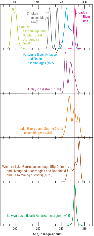
Kernel density estimator plots (Vermeesch, 2012) of all published and new middle and late Paleozoic U-Pb zircon ages from assemblages in, or relevant to, our study area in western Yukon and eastern Alaska. Data sources in addition to this study (table 2) and published ages listed in table 1 include the following: Delta mining district (Dashevsky and others, 2003), Bonnifield mining district (Dusel-Bacon and others, 2012; Slack and others, 2019), central and western Yukon-Tanana Upland (Aleinikoff and others, 1986; Dusel-Bacon and Aleinikoff, 1996; Dusel-Bacon and others, 2004, 2013), Finlayson Lake district (Murphy and others, 2006; Manor and others, 2020), and western Selwyn basin (Yukon Geological Survey, 2020a). Vertical bar shows the Cassiar terrane syenite, which marks the estimated age of initial rifting and opening of the Slide Mountain Ocean.
Viewed alone, the similarities of the expanded crystallization ages and geochemical signatures of the assemblages in the proposed parautochthon and allochthon presented above allow an alternative interpretation in which the Lake George and Scottie Creek assemblages and related assemblages in Yukon and Alaska are part of the rifted crustal fragment (Yukon-Tanana terrane), analogous to the Snowcap assemblage basement of the Yukon-Tanana terrane, rather than being part of the Laurentian continental margin that remained inboard of the Slide Mountain Ocean following rifting, as is proposed by many workers (for example, Dusel-Bacon and others 2006; Nelson and others, 2006; Piercey and others, 2006; Ryan and others, 2017, 2020). The previously mentioned similarities in amphibolite trace-element signatures and a lack of Paleozoic detrital zircons in the Snowcap and Lake George assemblages are consistent with a correlation of these two units. However, whether they were separated by the Slide Mountain Ocean is the key question in evaluating the parautochthonous versus allochthonous origin of the Lake George and Scottie Creek assemblages that we seek to re-examine.
Three other lines of evidence that were used in previous studies to support a parauthochthonous origin for the Lake George assemblage are herein re-evaluated, and we propose alternative explanations that could be consistent with an allochthonous origin for the Lake George and Scottie Creek assemblages. First, detrital zircons from the Lake George, Scottie Creek, Fortymile River, and Finlayson assemblages all have Paleoproterozoic and Neoarchean populations (Gleeson and others, 2000; Colpron and others, 2006b; Murphy and others, 2006, 2009; Nelson and Gehrels, 2007; Murphy and others, 2009; Piercey and Colpron, 2009; Holm-Denoma and Jones, 2016; Dusel-Bacon and others, 2017). However, middle Paleozoic detrital zircons are absent in samples from the Lake George and Scottie Creek assemblages, but metaclastic rocks in the Fortymile River and Finlayson assemblages commonly include at least a minor population of Late Devonian or, in some cases, Early Mississippian detrital zircons (Gleeson and others, 2000; Colpron and others, 2006b; Murphy and others, 2006; Nelson and Gehrels, 2007; Holm-Denoma and Jones, 2016). These younger zircon ages from the Fortymile River and Finlayson assemblages in the Yukon-Tanana terrane support a depositional age that overlaps with the timing of Late Devonian to Early Mississippian magmatism in these assemblages. There are very few constraints on the depositional ages for the metasedimentary component of the Lake George and Scottie Creek assemblages, although they clearly predate the adjacent crosscutting Late Devonian or Early Mississippian intrusions. This assumption of an age older than Late Devonian to Early Mississippian for Lake George assemblage strata agrees with Dusel-Bacon and others’ (2017) interpretation, which proposed that the detrital zircon age patterns from four parautochthonous units from east-central Alaska most resemble the detrital zircon age patterns determined for Neoproterozoic to Ordovician passive margin strata from northern and southern British Columbia. The presence of Late Devonian to Mississippian detrital zircons in the Yukon-Tanana terrane and their absence in the Lake George and Scottie Creek assemblages could simply confirm that the metasedimentary component of the Lake George assemblage predates that in the Yukon-Tanana terrane.
Second, the absence of Late Permian metamorphosed intrusions (Sulphur Creek orthogneiss equivalents) and Late Triassic to Early Jurassic intrusions in the Lake George assemblage and correlative assemblages, but the presence of these intrusions in the Yukon-Tanana terrane, as presently defined in the study area, was used as evidence that the Lake George assemblage and Yukon-Tanana terrane were not above the same subduction zone (fig. 3B) (for example, Hansen and Dusel-Bacon, 1998; Dusel-Bacon and others, 2015; Ryan and others, 2020). Had the Lake George and Scottie Creek assemblages been basement to the Yukon-Tanana terrane, these studies reasoned, the Lake George assemblage also would have been intruded by these late Permian to Jurassic magmatic suites. However, we propose the following alternative explanation for their absence in the Lake George and Scottie Creek assemblages. All of these suites of intrusions are interpreted to be the products of continental magmatic arcs, and such arcs are typically narrow (25–150 km wide; for example, Stern, 2002). Evidence that late Permian Klondike assemblage arc magmatism may have been areally restricted is also provided by the apparent absence of Klondike assemblage magmatism in the Yukon-Tanana terrane of the Finlayson Lake district, which lay just northeast of the study area during the late Permian. Subsequent deformation may have modified the original distribution of the arc rocks. Specifically, the entire region has experienced regional-scale, northeast-directed thrust imbrication prior to the Triassic (>212 Ma; Hansen and Dusel-Bacon, 1998) and possibly during the earlier Klondike orogeny in the latest Permian, and there are no constraints, as yet, on how much displacement took place on any of these thrust faults. In addition, original geologic relations were affected by origin-parallel contractional deformation during the Late Triassic to Early Jurassic, followed by extensional deformation in the Early Cretaceous (for example, Hansen and Dusel-Bacon, 1998). It is therefore possible that the Lake George and Scottie Creek assemblages represent part of the basement of the Yukon-Tanana terrane arc and the shallower parts of the arc system have been tectonically displaced from the originally underlying basement parts.
Third, the Early Cretaceous metamorphic cooling ages in lower plate tectonites of the Lake George assemblage in east-central Alaska (for example, Hansen and Dusel-Bacon, 1998; Dusel-Bacon and others, 2002) and Scottie Creek assemblage in the Australia Mountain domain of the southeastern Stewart River map area (Staples and others, 2013) contrast with the primarily Early Jurassic metamorphic cooling ages recorded in upper plate Yukon-Tanana terrane tectonites. The Early Cretaceous ages were interpreted to record unroofing of lower plate rocks from beneath the overlying Yukon-Tanana terrane (Pavlis, 1989; Hansen, 1990; Hansen and Dusel-Bacon, 1998; Dusel-Bacon and others, 2015). The presence of pervasive Early Cretaceous amphibolite-facies metamorphism and deformation that affected the Lake George and Scottie Creek assemblages, but apparently not the overlying Yukon-Tanana terrane are similar to that observed in many metamorphic core complexes elsewhere in the world (as suggested by Ryan and others, 2017). However, the contrast in the metamorphic cooling ages in the hanging wall versus the footwall does not prove that the two were tectonically distinct, but neither does it provide evidence that they were contiguous. The structurally deepest levels of the Finlayson Lake district comprise possible Snowcap assemblage metaclastic rocks that have been intruded by large bodies of granitic augen gneiss of the Grass Lakes plutonic suite (Murphy and others, 2006; Staples and others, 2016). These augen gneiss bodies yield Early Cretaceous Rb-Sr muscovite cooling ages (Mortensen, 1983), similar to ages of Lake George and Scottie Creek assemblage augen gneisses in our study area. These rock units appear to be structurally continuous with the overlying strata that represent Yukon-Tanana terrane arc and back-arc magmatism, with no evidence for an intervening Early Cretaceous extensional fault.
If the above discussed lines of evidence for the Lake George and Scottie Creek assemblages being parautochthonous are refuted and the alternative model in which they are part of the allochthon is accepted, the tectonic model shown in figure 3 would be modified to show the Lake George assemblage as the basement in the rifted continental margin fragment, thereby lying outboard, rather than inboard, of the Slide Mountain Ocean basin beginning in the middle Paleozoic. Subsequent Permian and early Mesozoic arcs would either not have intruded the Lake George and Scottie Creek assemblage portion of the basement, or those arc rocks would have been tectonically displaced or have not yet been recognized. According to this alternative hypothesis, the allochthonous Yukon-Tanana terrane would extend to the northwestern margin of the Fairbanks-Chena assemblage (thrust boundary shown on fig. 2) that Foster and others (1983) and Laird and Foster (1984) interpreted as a major zone of northwest-directed thrusting in which greenschist-facies quartzite and quartz-rich schist of the Yukon-Tanana terrane was emplaced on top of the Neoproterozoic to early Cambrian Wickersham grit unit. An allochthonous origin for this extensive and composite Yukon-Tanana terrane was previously proposed by other workers (Tempelman-Kluit, 1979; Coney and others, 1980; Churkin and others, 1982; Mortensen, 1992; Foster and others, 1994).
Ladue River Unit Affinity
Foster’s (1970) and Dusel-Bacon and others’ (2006) description of the rocks in the Ladue River unit as a package of greenschist-facies, mainly metaclastic rocks, with some amphibolite-facies rocks that have a strong greenschist-facies retrogressive overprint has been clarified by recent mapping and geochronological studies (Jones and others, 2017b; Twelker and others, 2019). Some of what Foster (1970) mapped in what was subsequently named the Ladue River unit is now recognized as being part of the overlying greenschist-facies Klondike assemblage, as originally proposed by Foster (1970) (figs. 2, 4). The rest of the Ladue River unit is now interpreted to be a thin (less than a few hundred meters thick), gently dipping structural panel of allochthonous Yukon-Tanana terrane assemblages (Jones and others, 2017b) that structurally overlies the parautochthonous Lake George assemblage (Twelker and others, 2019). The age and geochemical composition of the augen gneiss unit that we analyzed in this study from within the Ladue River unit are generally similar to those in both the Lake George and Fortymile River assemblages (fig. 13H, I). 40Ar/39Ar metamorphic cooling ages in the Lake George assemblage, however, are uniformly Early Cretaceous, whereas those in the Ladue River unit are Early to Middle Jurassic (Jones and others, 2017b) like those in the Fortymile River assemblage. Regional map patterns indicate that the Early Cretaceous extensional fault that forms the northern contact of the Lake George assemblage with the Fortymile River assemblage in Alaska and western Yukon must wrap around to the south and then northwest along the southern contact of the Fiftymile batholith (fig. 4) and then continue as the contact between the Lake George assemblage in the footwall and the Ladue River unit in the hanging wall. We therefore think it probable that the Ladue River unit is part of the Fortymile River assemblage and was probably juxtaposed against the Lake George assemblage across an Early Jurassic thrust fault that was subsequently reactivated as an Early Cretaceous extensional structure. Given that the Ladue River unit rocks form very thin tectonic slices as mapped by Jones and others (2017b), it would not be surprising to see evidence for substantial amounts of post-faulting retrogression from fluids circulating along the fault surfaces.
Possible Correlatives of the Chicken Assemblage
The U-Pb zircon age of 319.4±1.1 Ma that we report here for the Chicken assemblage tonalitic sample 38, together with the 332.6±5.7 Ma U-Pb age reported by Dusel-Bacon and others (2013) and the middle Paleozoic, possibly Mississippian, macrofossil and conodont ages for limestones in the Chicken assemblage, indicates that this assemblage is Late Mississippian to Early Pennsylvanian and therefore younger than either the Fortymile River assemblage or the Lake George assemblage. Its lower metamorphic grade also distinguishes it from these other two amphibolite-facies assemblages; the presence of a weak to moderate recrystallization foliation in the Chicken assemblage also makes it different from the less deformed rocks of the Slide Mountain-Seventymile terrane.
The Klinkit assemblage includes several Middle Mississippian to early Permian (about 342–269 Ma) arc-related stratified units throughout the Yukon-Tanana terrane elsewhere in Yukon and northern British Columbia, including the Klinkit Group and the informal Little Salmon formation (Colpron and others, 2006a; Nelson and others, 2006). We speculate that the Chicken assemblage may be, in part, correlative with the approximately 342 to 314 Ma Little Salmon formation as recognized in the Glenlyon map area in central Yukon (fig. 1, locality D) (Colpron and others, 2006b). The Little Salmon formation unconformably overlies a previously deformed and metamorphosed assemblage of Late Devonian to Early Mississippian metavolcanic and metasedimentary rocks of the Finlayson assemblage and metaplutonic rocks of the Simpson Lake plutonic suite. However, evidence against correlation is (1) the Little Salmon formation is dominated by felsic to intermediate-composition volcaniclastic and volcanic rocks (Colpron and others, 2006b), whereas igneous rocks in the Chicken assemblage are primarily mafic and (2) no Triassic intrusions cut the Little Salmon formation, but the Triassic Taylor Mountain batholith intrudes the Chicken assemblage. A small body of felsite within a large area of Snowcap assemblage in the western McQuesten map area, east of the Stewart River map area in west-central Yukon, gives a U-Pb zircon age of 322.1±2.7 Ma (Knight and others, 2013; Staples and others, 2016; Yukon Geological Survey, 2020b) and may also be part of this cryptic magmatic event.
The Klinkit assemblage takes its name from the Klinkit Group (fig. 1) an arc-related volcanic-sedimentary sequence in the Yukon-Tanana terrane of southern Yukon and northern British Columbia. Although it contains Visean (Middle Mississippian) limestones, the absolute age of Klinkit magmatism is approximately 281 Ma (Roots and others, 2006), so igneous activity in it appears to be somewhat younger than in the Chicken assemblage.
Another possible correlation, based on our two igneous crystallization ages from the Chicken assemblage, is with some of the igneous rocks in the Stikine assemblage (fig. 1) that forms a separate arc sequence that is part of Stikinia. Comparable ages from this arc are from (1) the Takhini assemblage of southern Yukon (fig. 1, locality E) (323 Ma; Hart, 1997) and indicated by a 338 Ma peak in detrital zircons in the Upper Triassic fluvial sedimentary rocks of the Mandanna member, Lewes River Group, near the city of Whitehorse (fig. 1) that were derived from the nearby Takhini assemblage (Colpron and others, 2015) and (2) felsic units in the Stikine assemblage in the Iskut area of northwestern British Columbia that yielded TIMS U-Pb zircon ages of 344 Ma and 319 Ma (Gunning and others, 2006) (fig. 1, locality F1) and 342 Ma (Ash and others, 1997) (fig. 1, locality F2). The informal Zymoetz group, a Stikine assemblage correlative in west-central British Columbia near Terrace (located south of the area in fig. 1), yields U-Pb zircon ages of 325 to 323 Ma (Nelson, 2017).
One argument in favor of interpreting the Chicken assemblage as having a Stikinia affinity, different from underlying thrust sheets, is that the Chicken assemblage hosts the Triassic Taylor Mountain batholith, whereas Triassic intrusive bodies have not yet been recognized in the Fortymile River assemblage in Alaska. Late Triassic intrusions also are relatively rare in the Yukon-Tanana terrane of Yukon and northern British Colombia, except in a belt in central Yukon that overlaps the Stikine-Yukon-Tanana terrane boundary (Stikine and Pyroxene Mountain suites) at about 63° N. latitude, 138° W. longitude (Sack and others, 2020). In contrast, large Late Triassic intrusive bodies are a hallmark of Stikinia, where they are interpreted as the roots of widespread volcanic sequences of the Stuhini-Takla supracrustal arc (Nelson and van Straaten, 2021). This could be used as an argument for a tectonic overlap of Stikinia onto the Yukon-Tanana terrane during the Late Triassic or Early Jurassic. Evidence against this tectonic juxtaposition, however, is paleomagnetic data from the Taylor Mountain batholith, which indicate that the batholith and the klippen thrust sheets of the Fortymile River and Chicken assemblages have been part of the North American margin since the Late Triassic, whereas Stikinia and associated terranes from the Intermontane Belt were obducted onto North America during the Late Cretaceous to Middle Eocene (Symons and others, 2009).
Thus, the Chicken assemblage continues to be an enigma. In addition to the correlation constraints posed by the U-Pb zircon crystallization ages of Chicken assemblage tonalites from our study and from the western exposure of the assemblage, another potential means of correlating this assemblage with others is to compare trace-element signatures of the assemblage with those from the potential correlatives. Whole-rock trace-element ratios of the incompatible elements Ta, Yb, Nb, Th, Y, La, Hf, and REE from the tonalitic gneiss from the western exposure of the assemblage that gave an age of 332.6±5.6 Ma have geochemical characteristics of LREE-enriched island-arc tholeiite. Two samples of associated mafic metavolcanic rocks also have island-arc tholeiite trace-element signatures; analyses plot in proximity to N-MORB and back-arc basin basalt compositional fields (Dusel-Bacon and others, 2013). Dusel-Bacon and others (2013) concluded that these trace-element signatures, along with those from the Nasina and Fortymile River assemblages analyzed from the western area, indicate an N-MORB composition with added crustal contamination and (or) subduction-zone enrichment, suggesting that the Chicken assemblage, like the Nasina and Fortymile River assemblages, formed as island-arc tholeiite in a back-arc setting. Whole-rock geochemical data are also reported from the eastern exposure of the Chicken assemblage, east of the Taylor Mountain batholith (Szumigala and others, 2000). However, Nb, Y, and Zr are the only trace elements that are reported in the dataset that are used for tectonic discrimination of mafic rocks and the plot that utilizes these elements indicates two different tectonic environments (within-plate tholeiitic basalt and volcanic-arc basalt) for the data (see fig. 10F of Dusel-Bacon and others, 2006). At present, geochemical data are inadequate to clearly correlate the Chicken assemblage with any specific arc assemblage in other parts of the Yukon-Tanana terrane in Canada or with the separate Stikinia arc. However, existing trace-element geochemical signatures from the Chicken assemblage differentiate the greenstones in that complex from those in the Little Salmon formation that have ocean island basalt geochemical signatures (Colpron and others, 2006b) and from those in the Seventymile terrane that have predominantly N-MORB to E-MORB geochemical signatures (Dusel-Bacon and others, 2006). More field mapping, whole-rock trace element analysis, and isotopic dating would help resolve the origin and affinity of this cryptic assemblage.
Conclusions
The tectonic evolution of and relation between the Yukon-Tanana terrane and the Lake George assemblage, and other associated tectonic assemblages in western Yukon and eastern Alaska, have been debated for decades. The Yukon-Tanana terrane is widely considered to be an allochthonous rifted fragment derived from the Laurentian continental margin, whereas the Lake George assemblage and associated assemblages are currently interpreted to be the part of the parautochthonous continental margin of western North America (Laurentia). To address these topics, we present 40 new U-Pb zircon ages and 20 new whole-rock geochemical analyses. We incorporate these data into a new compilation of available geological mapping for a large area that straddles the Alaska-Yukon border, together with 34 previously published U-Pb age determinations and an extensive geochemical database of metaigneous rocks from Late Devonian to Early Mississippian and middle to late Permian assemblages in this area.
Magmatism in the Lake George assemblage and related assemblages occurred in two pulses from approximately 371 to 360 Ma and approximately 358 to 347 Ma; geochemical discrimination diagrams indicate a large crustal component, possibly indicative of arc magmatism, for felsic metaigneous rocks, and a range of tectonic environments for mafic rocks. Magmatism in the Fortymile River assemblage, related assemblages, and parts of the Nasina assemblage—all parts of the Yukon-Tanana terrane—are mainly Early Mississippian and span a crystallization age range of approximately 361 to 343 Ma; geochemical discrimination diagrams for these rocks indicate primarily arc geochemical signatures for both mafic and felsic rocks. Middle to late Permian crystallization ages (approximately 261–253 Ma) are indicated for felsic metaigneous rocks in the Klondike assemblage and some of the felsic metaigneous rocks in the Nasina assemblage. Based on our mapping, we propose the existence of a possible unconformity between the Mississippian and Permian felsic metavolcanic rocks within the Nasina assemblage that is marked by sporadic occurrences of stretched pebble conglomerate.
Our combined database supports the well-established model of a magmatic arc comprising the Fortymile River and Finlayson assemblages of the rifted Yukon-Tanana terrane continental fragment on which a middle to late Permian arc (Klondike assemblage) was later built. The assemblages of the Yukon-Tanana terrane were subsequently intruded by Late Triassic to Early Jurassic granitoids, presumably during re-accretion of the Yukon-Tanana terrane to the continental margin. Permian and Late Triassic to Early Jurassic intrusions have not been mapped in the now structurally lower plate Lake George assemblage; their absence is one of the lines of evidence that have been used to support the parautochthonous, rather than allochthonous, origin of the Lake George assemblage and related assemblages. Our new data, together with previously published ranges of igneous crystallization ages and geochemical tectonic signatures of the Late Devonian to Early Mississippian magmatic rocks in the Lake George assemblage and associated assemblages and in the Fortymile River, Nasina, and correlated assemblages of the Yukon-Tanana terrane, indicate that the currently accepted interpretation of the Lake George assemblage and associated rocks being part of parauthochthonous North America is not the only possible interpretation of this tectonic entity. Approximately half of the dated intrusive rocks in the Lake George assemblage are contemporaneous with the <361 Ma metaigneous rocks of the Yukon-Tanana terrane arc. We speculate that our approximate U-Pb age of 361 Ma for quartz syenite in part of the North American continental margin in south-central Yukon defines the beginning of rifting of the Laurentian margin. Although the currently favored model of prolonged middle Paleozoic subduction and extension in both the Yukon-Tanana terrane and parautochthonous North America allows for simultaneous middle Paleozoic magmatism on both sides of the Slide Mountain Ocean, we now propose an alternative hypothesis in which the Lake George assemblage represents a deeper portion of the rifted Yukon-Tanana terrane arc. If this is the case, the absence of Permian and Late Triassic to Early Jurassic arc rocks in the Lake George assemblage could be explained by either having the arcs of these ages not be wide enough to have affected the Lake George assemblage, or by tectonic displacement of these arc rocks away from the Lake George assemblage.
Our approximate 259 Ma U-Pb zircon age and geochemistry for metarhyolite in the Seventymile terrane in Alaska, which comprises remnants of the back-arc basin that separated the Yukon-Tanana terrane from the Laurentian continental margin, confirm the presence of a late middle Permian volcanic arc component to the terrane. Our approximate 319 Ma U-Pb zircon age from the Chicken assemblage (as redefined in this study) in eastern Alaska, combined with previously reported fossil ages and a U-Pb zircon age from this assemblage, indicates that it is a Late Mississippian to Early Pennsylvanian arc assemblage. We propose several other relatively young, locally developed, arc assemblages outboard of the ancient continental margin of Laurentia that may correlate with the Chicken assemblage, but we consider its origin to remain an enigma.
Acknowledgments
It would be impossible to list all the researchers who have contributed ideas and discussion to this study over the many years that it has been ongoing. We thank Don Murphy, Maurice Colpron, Helen Foster, Steve Piercey, Jim Ryan, and Steve Gordey, all of whom were instrumental in the completion of the study. JoAnne Nelson has unselfishly shared insight and her vast knowledge of the northern Cordillera for more than two decades. Rainer Newberry is acknowledged for adding his X-ray fluorescence analyses of some key elements to our geochemical analyses of augen gneiss. This report benefited from thorough technical peer reviews by Jamey Jones and JoAnne Nelson. Charlie Bacon provided invaluable assistance to Dusel-Bacon in the field and is wholeheartedly thanked for his patience, moral support, and collection of the freshest geochemical samples imaginable. Monica Erdman did an outstanding job of editing this report, helping us clearly and accurately communicate our ideas.
References Cited
Aleinikoff, J.N., Dusel-Bacon, C., Foster, H.L., and Futa, K., 1981, Proterozoic zircon from augen gneiss, Yukon-Tanana Upland, east-central Alaska: Geology, v. 9, no. 10, p. 469–473, https://doi.org/10.1130/0091-7613(1981)9<469:PZFAGY>2.0.CO;2.
Aleinikoff, J.N., Dusel-Bacon, C., and Foster, H.L., 1986, Geochronology of augen gneiss and related rocks, Yukon-Tanana terrane, east-central Alaska: Geological Society of America Bulletin, v. 97, no. 5, p. 626–637, https://doi.org/10.1130/0016-7606(1986)97<626:GOAGAR>2.0.CO;2.
Ash, C.H., MacDonald, R.J.W., Stinson, P.K., Fraser, T.M., Read, P.R., Psutka, J.F., Nelson, K.J., Arden, K.M., Friedman, R.M., and Lefebure, D.V., 1997, Geology and mineral occurrences of the Tatogga Lake area, NTS 104G/9NE, 16SE and 104H/12NW, 13SW: British Columbia Geological Survey Open File 1997-3, scale 1:50,000.
Bacon, C.R., and Druitt, T.H., 1988, Compositional evolution of the zoned calcalkaline magma chamber of Mount Mazama, Crater Lake, Oregon: Contributions to Mineralogy and Petrology, v. 98, no. 2, p. 224–256, https://doi.org/10.1007/BF00402114.
Beaudoin, B.C., Fuis, G.S., Lutter, W.J., Mooney, W.D., and Moore, T.E., 1994, Crustal velocity structure of the northern Yukon-Tanana upland, central Alaska—Results from TACT refraction/wide-angle reflection data: Geological Society of America Bulletin, v. 106, no. 8, p. 981–1001, https://doi.org/10.1130/0016-7606(1994)106<0981:CVSOTN>2.3.CO;2.
Beranek, L.P., and Mortensen, J.K., 2011, The timing and provenance record of the Late Permian Klondike orogeny in northwestern Canada and arc-continent collision along western North America: Tectonics, v. 30, no. 5, article TC5017, https://doi.org/10.1029/2010TC002849.
Berman, R.G., Ryan, J.J., Gordey, S.P., and Villeneuve, M., 2007, Permian to Cretaceous polymetamorphic evolution of the Stewart River region, Yukon-Tanana terrane, Yukon, Canada—P-T evolution linked with in situ SHRIMP monazite geochronology: Journal of Metamorphic Geology, v. 25, no. 7, p. 803–827, https://doi.org/10.1111/j.1525-1314.2007.00729.x.
Bradley, D.C., McClelland, W.C., Wooden, J.L., Till, A.B., Roeske, S.M., Miller, M.L., Karl, S.M., and Abbott, J.G., 2007, Detrital zircon geochronology of some Neoproterozoic to Triassic rocks in interior Alaska, in Ridgway, K.D., Trop, J.M., Glen, J.M.G., and O’Neill, J.M., eds., Tectonic growth of a collisional continental margin—Crustal evolution of southern Alaska: Geological Society of America Special Paper 431, p. 155–189, https://doi.org/10.1130/2007.2431(07)
Canil, D., Johnston, S.T., Evers, K., Shellnutt, J.G., and Creaser, R.A., 2003, Mantle exhumation in an early Paleozoic passive margin, northern Cordillera, Yukon: The Journal of Geology, v. 111, no. 3, p. 313–327, https://doi.org/10.1086/373971.
Churkin, M., Jr., Foster, H.L., Chapman, R.M., and Weber, F.R., 1982, Terranes and suture zones in east-central Alaska: Journal of Geophysical Research, v. 87, no. B5, p. 3718–3730, https://doi.org/10.1029/JB087iB05p03718.
Cleven, N.R., Ryan, J.J., Kellett, D.A., Zagorevski, A., McClelland, B., Joyce, N.L., Crowley, J., and Parsons, A., 2019, Detrital-zircon age-distribution correlations between Snowcap assemblage basement of the Yukon-Tanana terrane and Proterozoic to Devonian stratigraphy of the Laurentian margin platformal strata, Yukon-British Columbia: Geological Survey of Canada Scientific Presentation 113, 1 sheet, https://doi.org/10.4095/321395.
Cockfield, W.E., 1921, Sixtymile and Ladue Rivers area, Yukon: Geological Survey of Canada Memoir 123, 60 p., 1 sheet, https://doi.org/10.4095/101681.
Cohen, K.M., Finney, S.C., Gibbard, P.L., and Fan, J.-X., 2013, The ICS International Chronostratigraphic Chart (v. 2020/01): Episodes, v. 36, no. 3, p. 199–204, https://doi.org/10.18814/epiiugs/2013/v36i3/002.
Colpron, M., Nelson, J.L., and Murphy, D.C., 2006a, A tectonostratigraphic framework for the pericratonic terranes of the northern Canadian Cordillera, in Colpron, M., and Nelson, J.L., eds., Paleozoic evolution and metallogeny of pericratonic terranes at the ancient Pacific margin of North America, Canadian and Alaskan Cordillera: Geological Association of Canada Special Paper 45, p. 1–23.
Colpron, M., Mortensen, J.K., Gehrels, G.E., and Villeneuve, M., 2006b, Basement complex, Carboniferous magmatism and Paleozoic deformation in Yukon-Tanana terrane of central Yukon—Field, geochemical and geochronological constraints from Glenlyon map area, in Colpron, M., and Nelson, J.L., eds., Paleozoic evolution and metallogeny of pericratonic terranes at the ancient Pacific margin of North America, Canadian and Alaskan Cordillera: Geological Association of Canada Special Paper 45, p. 131–151.
Colpron, M., Crowley, J.L., Gehrels, G., Long, D.G.F., Murphy, D.C., Beranek, L., and Bickerton, L., 2015, Birth of the northern Cordilleran orogen, as recorded by detrital zircons in Jurassic synorogenic strata and regional exhumation in Yukon: Lithosphere, v. 7, no. 5, p. 541–562, https://doi.org/10.1130/L451.1.
Colpron, M., Israel, S., and Friend, M.A., comps., 2016, Yukon plutonic suites: Yukon Geological Survey Open File 2016-37, scale 1:750,000, accessed June 26, 2023, at https://ygsftp.gov.yk.ca/publications/openfile/2016/OF2016-37.pdf.
Coney, P.J., Jones, D.L., and Monger, J.W.H., 1980, Cordillera suspect terranes: Nature, v. 288, no. 5789, p. 329–333, https://doi.org/10.1038/288329a0.
Dashevsky, S.S., Schaefer, C.F., and Hunter, E.N., 2003, Bedrock geologic map of the Delta mineral belt, Tok mining district, Alaska: Alaska Division of Geological and Geophysical Surveys Professional Report 122, 122 p., 2 sheets, scale 1:63,360, https://doi.org/10.14509/2923.
Day, W.C., Gamble, B.M., Henning, M.W., and Smith, B.D., 2000, Geologic setting of the Fortymile River area—Polyphase deformational history within part of the eastern Yukon-Tanana uplands of Alaska, in Kelly, K.D., and Gough, L.P., eds., Geologic studies in Alaska by the U.S. Geological Survey, 1998: U.S. Geological Survey Professional Paper 1615, p. 65–82.
Day, W.C., Aleinikoff, J.N., and Gamble, B.M., 2002, Geochemistry and age constraints on metamorphism and deformation in the Fortymile River area, eastern Yukon-Tanana Upland, Alaska, in Wilson, F.H., and Galloway, J.P., eds., Studies by the U.S. Geological, Survey in Alaska, 2000: U.S. Geological Survey Professional Paper 1662, p. 5–18.
Day, W.C., O’Neill, J.M., Dusel-Bacon, C., Aleinikoff, J.N., and Siron, C.R., 2014, Geologic map of the Kechumstuk fault zone in the Mount Veta area, Fortymile mining district, east-central Alaska: U.S. Geological Survey Scientific Investigations Map 3291, scale 1:63,360, https://doi.org/10.3133/sim3291.
Dodds, C.J., 1995, Denali fault system, in Transcurrent faults, pt. F of Structural styles, chap. 17 of Gabrielse, H., and Yorath, C.J., eds., Geology of the Cordilleran orogen in Canada: Geological Survey of Canada Geology of Canada Series no. 4, p. 656–657, https://doi.org/10.4095/134119.
Dover, J.H., 1994, Geology of part of east-central Alaska, chap. 5 of Plafker, G., and Berg, H.C., eds., The geology of Alaska, v. G–1 of The geology of North America: Boulder, Colo., Geological Society of America, p. 153–204, https://doi.org/10.1130/DNAG-GNA-G1.153.
Dusel-Bacon, C., and Aleinikoff, J.N., 1985, Petrology and tectonic significance of augen gneiss from a belt of Mississippian granitoids in the Yukon-Tanana terrane, east-central Alaska: Geological Society of America Bulletin, v. 96, no. 4, p. 411–425, https://doi.org/10.1130/0016-7606(1985)96<411:PATSOA>2.0.CO;2.
Dusel-Bacon, C., and Aleinikoff, J.N., 1996, U-Pb zircon and titanite ages for augen gneiss from the Divide Mountain area, eastern Yukon-Tanana upland, Alaska, and evidence for the composite nature of the Fiftymile Batholith, in Moore, T.E., and Dumoulin, J.A., eds., Geologic studies in Alaska by the U.S. Geological Survey, 1994: U.S. Geological Survey Bulletin 2152, p. 131–141.
Dusel-Bacon, C., and Cooper, K.M., 1999, Trace-element geochemistry of metabasaltic rocks from the Yukon-Tanana Upland and implications for the origin of tectonic assemblages in east-central Alaska: Canadian Journal of Earth Sciences, v. 36, no. 10, p. 1671–1695, https://doi.org/10.1139/e99-077.
Dusel-Bacon, C., and Hansen, V.L., 1992, High-pressure amphibolite-facies metamorphism and deformation within the Yukon-Tanana and Taylor Mountain terranes, eastern Alaska, in Bradley, D.C., and Dusel-Bacon, C., eds., Geologic studies in Alaska by the U.S. Geological Survey, 1991: U.S. Geological Survey Bulletin 2041, p. 140–159.
Dusel-Bacon, C., and Harris, A.G., 2003, New occurrences of late Paleozoic and Triassic fossils from the Seventymile and Yukon-Tanana terranes, east-central Alaska, with comments on previously published occurrences in the same area, in Galloway, J.P., ed., Studies in Alaska by the U.S. Geological Survey, 2001: U.S. Geological Survey Professional Paper 1678, p. 5–30.
Dusel-Bacon, C., and Mortensen, J.K., 2023, New U-Pb geochronology and geochemistry of Paleozoic metaigneous rocks from western Yukon and eastern Alaska: U.S. Geological Survey data release, https://doi.org/10.5066/P93ZWGA1.
Dusel-Bacon, C., and Williams, I.S., 2009, Evidence for prolonged mid-Paleozoic plutonism and ages of crustal sources in east-central Alaska from SHRIMP U–Pb dating of syn-magmatic, inherited, and detrital zircon: Canadian Journal of Earth Sciences, v. 46, no. 1, p. 21–39, https://doi.org/10.1139/E09-005.
Dusel-Bacon, C., Hansen, V.L., and Scala, J.A., 1995, High-pressure amphibolite facies dynamic metamorphism and the Mesozoic tectonic evolution of an ancient continental margin, east-central Alaska: Journal of Metamorphic Geology, v. 13, no. 1, p. 9–24, https://doi.org/10.1111/j.1525-1314.1995.tb00202.x.
Dusel-Bacon, C., Bressler, J.R., Takaoka, H., Mortensen, J.K., Oliver, D.H., Leventhal, J.S., Newberry, R.J., and Bundtzen, T.K., 1998, Stratiform zinc-lead mineralization in Nasina assemblage rocks of the Yukon-Tanana Upland in east-central Alaska: U.S. Geological Survey Open-File Report 98–340, 26 p., https://doi.org/10.3133/ofr98340.
Dusel-Bacon, C., Lanphere, M.A., Sharp, W.D., Layer, P.W., and Hansen, V.L., 2002, Mesozoic thermal history and timing of structural events for the Yukon-Tanana Upland, east-central Alaska—40Ar/39Ar data from metamorphic and plutonic rocks: Canadian Journal of Earth Sciences, v. 39, no. 6, p. 1013–1051, https://doi.org/10.1139/e02-018.
Dusel-Bacon, C., Wooden, J.L., and Hopkins, M.J., 2004, U-Pb zircon and geochemical evidence for bimodal mid-Paleozoic magmatism and syngenetic base-metal mineralization in the Yukon-Tanana terrane, Alaska: Geological Society of America Bulletin, v. 116, no. 7, p. 989–1015, https://doi.org/10.1130/B25342.1.
Dusel-Bacon, C., Hopkins, M.J., Mortensen, J.K., Dashevsky, S.S., Bressler, J.R., and Day, W.C., 2006, Paleozoic tectonic and metallogenic evolution of the pericratonic rocks of east-central Alaska and adjacent Yukon Territory, in Colpron, M., and Nelson, J.L., eds., Paleozoic evolution and metallogeny of pericratonic terranes at the ancient Pacific margin of North America, Canadian and Alaskan Cordillera: Geological Association of Canada Special Paper 45, p. 25–74.
Dusel-Bacon, C., Foley, N.K., Slack, J.F., Koenig, A.E., and Oscarson, R.L., 2012, Peralkaline- and calc-alkaline-hosted volcanogenic massive sulfide deposits of the Bonnifield district, east central Alaska: Economic Geology, v. 107, no. 7, p. 1403–1432, https://doi.org/10.2113/econgeo.107.7.1403.
Dusel-Bacon, C., Day, W.C., and Aleinikoff, J.N., 2013, Geochemistry, petrography, and zircon U-Pb geochronology of Paleozoic metaigneous rocks in the Mount Veta area of east-central Alaska—Implications for the evolution of the westernmost part of the Yukon-Tanana terrane: Canadian Journal of Earth Sciences, v. 50, no. 8, p. 826–846, https://doi.org/10.1139/cjes-2013-0004.
Dusel-Bacon, C., Aleinikoff, J.N., Day, W.C., and Mortensen, J.K., 2015, Mesozoic magmatism and timing of epigenetic Pb-Zn-Ag mineralization in the western Fortymile mining district, east-central Alaska—Zircon U-Pb geochronology, whole-rock geochemistry, and Pb isotopes: Geosphere, v. 11, no. 3, p. 786–822, https://doi.org/10.1130/GES01092.1.
Dusel-Bacon, C., Holm-Denoma, C.S., Jones, J.V.I.I.I., III, Aleinikoff, J.N., and Mortensen, J.K., 2017, Detrital zircon geochronology of quartzose metasedimentary rocks from parautochthonous North America, east-central Alaska: Lithosphere, v. 9, no. 6, p. 927–952, https://doi.org/10.1130/L672.1.
Foster, H.L., Keith, T.E.C., and Menzie, W.D., 1994, Geology of the Yukon-Tanana area of east-central Alaska, chap. 6 of Plafker, G., and Berg, H.C., eds., The geology of Alaska, v. G–1 of The geology of North America: Boulder, Colo., Geological Society of America, p. 205–240, https://doi.org/10.1130/DNAG-GNA-G1.205.
Gabrielse, H., and Campbell, R.B., 1991, Upper Proterozoic assemblages, chap. 6 of Gabrielse, H., and Yorath, C.J., eds., Geology of the Cordilleran orogen in Canada: Geological Survey of Canada Geology of Canada Series no. 4, p. 125–150, https://doi.org/10.4095/134085.
Gabrielse, H., Monger, J.W.H., Wheeler, J.O., and Yorath, C.J., 1991, Morphogeological belts, tectonic assemblages and terranes, pt. A of Tectonic framework, chap. 2 of Gabrielse, H., and Yorath, C.J., eds., Geology of the Cordilleran orogen in Canada: Geological Survey of Canada Geology of Canada Series no. 4, p. 15–28, https://doi.org/10.4095/134073.
Gabrielse, H., Murphy, D.C., and Mortensen, J.K., 2006, Cretaceous and Cenozoic dextral orogen-parallel displacements, magmatism and paleogeography, north-central Canadian Cordillera, in Haggart, J.W., Enkin, R.J., and Monger, J.W.H., eds., Paleogeography of the North American Cordillera—Evidence for and against large-scale displacements: Geological Association of Canada Special Paper 46, p. 255–276.
Gehrels, G., and Pecha, M., 2014, Detrital zircon U-Pb geochronology and Hf isotope geochemistry of Paleozoic and Triassic passive margin strata of western North America: Geosphere, v. 10, no. 1, p. 49–65, https://doi.org/10.1130/GES00889.1.
Gordey, S.P., and Ryan, J.J., 2005, Geology, Stewart River area (115 N, 115-O and part of 115J), Yukon Territory: Geological Survey of Canada Open File 4970, 1 sheet, scale 1:250,000, https://doi.org/10.4095/221149.
Granitto, M., Wang, B., Shew, N.B., Karl, S.M., Labay, K.A., Werdon, M.B., Seitz, S.S., and Hoppe, J.E., 2019a, Alaska Geochemical Database version 3.0 (AGDB3) including best value data compilations for rock, sediment, soil, mineral, and concentrate sample media: U.S. Geologica Survey data release, https://doi.org/10.5066/P98NHRAD.
Granitto, M., Wang, B., Shew, N.B., Karl, S.M., Labay, K.A., Werden, M.B., Seitz, S.S., and Hoppe, J.E., 2019b, Alaska Geochemical Database Version 3.0 (AGDB3)—Including “best value” data compilations for rock, sediment, soil, mineral, and concentrate sample media: U.S. Geological Survey Data Series 1117, 33 p., https://doi.org/10.3133/ds1117.
Gunning, M.H., Hodder, R.W., and Nelson, J.L., 2006, Contrasting volcanic styles and their tectonic implications for the Paleozoic Stikine assemblage, western Stikine terrane, northwestern British Columbia, in Colpron, M., and Nelson, J.L., eds., Paleozoic evolution and metallogeny of pericratonic terranes at the ancient Pacific margin of North America, Canadian and Alaskan Cordillera: Geological Association of Canada Special Paper 45, p. 203–229.
Hansen, V.L., 1990, Yukon-Tanana terrane; a partial acquittal: Geology, v. 18, no. 4, p. 365–369, https://doi.org/10.1130/0091-7613(1990)018<0365:YTTAPA>2.3.CO;2.
Hansen, V.L., Goodge, J.W., Keep, M., and Oliver, D.H., 1993, Asymmetric rift interpretation of the western North American margin: Geology, v. 21, no. 12, p. 1067–1070, https://doi.org/10.1130/0091-7613(1993)021<1067:ARIOTW>2.3.CO;2.
Hansen, V.L., and Dusel-Bacon, C., 1998, Structural and kinematic evolution of the Yukon-Tanana upland tectonites, east-central Alaska—A record of late Paleozoic to Mesozoic crustal assembly: Geological Society of America Bulletin, v. 110, no. 2, p. 211–230, https://doi.org/10.1130/0016-7606(1998)110<0211:SAKEOT>2.3.CO;2.
Hansen, V.L., Heizler, M.T., and Harrison, T.M., 1991, Mesozoic thermal evolution of the Yukon-Tanana composite terrane—New evidence from 40Ar/39Ar data: Tectonics, v. 10, no. 1, p. 51–76, https://doi.org/10.1029/90TC01930.
Hildreth, W., and Moorbath, S., 1988, Crustal contributions to arc magmatism in the Andes of Central Chile: Contributions to Mineralogy and Petrology, v. 98, no. 4, p. 455–489, https://doi.org/10.1007/BF00372365.
Hildreth, W., Halliday, A.N., and Christiansen, R.L., 1991, Isotopic and chemical evidence concerning the genesis and contamination of the basaltic and rhyolitic magma beneath the Yellowstone Plateau volcanic field: Journal of Petrology, v. 32, no. 1, p. 63–138, https://doi.org/10.1093/petrology/32.1.63.
Holm-Denoma, C.S., and Jones, J.V., III, 2016, Detrital zircon lineages in the allochthonous Yukon-Tanana terrane and parautochthonous North American basement, eastern Alaska and western Yukon [abs.].: Whitehorse, Yukon, Geological Association of Canada–Mineralogical Association of Canada Joint Annual Meeting, v. 39, p. 36, accessed May 31, 2016, at https://gac.ca/wp-content/uploads/2018/11/2016_GAC2016_AbstractVol.pdf.
Jones, J.V., III, Caine, J.S., Holm-Denoma, C.S., Ryan, J.J., Benowitz, J.A., and Drenth, B.J., 2017a, Unraveling the boundary between the Yukon-Tanana terrain and parautochthonous North America in eastern Alaska [abs.]: Geological Society of America Abstracts with Programs, v. 49, no. 6, https://doi.org/10.1130/abs/2017AM-304142.
Jones, J.V., III, Todd, E., Caine, J.S., Holm-Denoma, C.S., Ryan, J.J., and Benowitz, J.A., 2017b, Late Permian (ca. 267–257 Ma) magmatism, deformation, and metamorphic and lithotectonic associations of the Ladue River unit in east-central Alaska [abs.]: Geological Society of America Abstracts with Programs, v. 49, no. 6, https://doi.org/10.1130/abs/2017AM-304170.
Johnson, D.M., Hooper, P.R., and Conrey, R.M., 1999, XRF analysis of rocks and minerals for major and trace elements on a single low dilution Li-tetraborate fused bead: Advances in X-ray Analysis—Proceedings of the Denver X-ray Conference, v. 41, p. 843–867, accessed June 26, 2023, at https://environment.wsu.edu/facilities/geoanalytical-lab/technical-notes/xrf-method.
Johnston, S.T., Mortensen, J.K., and Erdmer, P., 1996, Igneous and metaigneous age constraints for the Aishihik metamorphic suite, southwest Yukon: Canadian Journal of Earth Sciences, v. 33, no. 11, p. 1543–1555, https://doi.org/10.1139/e96-117.
Johnston, S.T., Canil, D., and Heaman, L.H., 2007, Permian exhumation of the Buffalo Pitts orogenic peridotite massif, northern Cordillera, Yukon: Canadian Journal of Earth Sciences, v. 44, no. 3, p. 275–286, https://doi.org/10.1139/e06-078.
Joyce, N.L., Ryan, J.J., Colpron, M., Hart, C.J.R., and Murphy, D.C., 2015, A compilation of 40Ar/39Ar age determinations for igneous and metamorphic rocks, and mineral occurrences from central and southeast Yukon: Geological Survey of Canada Open File 7924, 229 p., https://doi.org/10.4095/297446.
Keith, T.E.C., Foster, H.L., Foster, R.L., Post, E.V., and Lembeck, W.L., 1981, Geology of an Alpine-type peridotite in the Mount Sorenson area, east-central Alaska: U.S. Geological Survey Professional Paper 1170-A, 9 p. https://doi.org/10.3133/pp1170A
Klepacki, D.W., and Wheeler, J.O., 1985, Stratigraphic and structural relations of Milford, Kaslo and Slocan groups, Goat Range, Lardeau and Nelson map areas, British Columbia, in Current research, part A: Geological Survey of Canada Paper 85-1A, p. 277–286, https://doi.org/10.4095/120053.
Knight, E., Schneider, D.A., and Ryan, J.J., 2013, Thermochronology of the Yukon-Tanana terrane, west-central Yukon—Evidence for Jurassic extension and exhumation in the northern Canadian Cordillera: The Journal of Geology, v. 121, no. 4, p. 371–400, https://doi.org/10.1086/670721.
Kroeger, E.D.L., Colpron, M., Piercey, S.J., McClelland, W.C., and Gehrels, G.E., 2019, Detrital zircon provenance study of the Yukon-Tanana terrane in Yukon, Canada [abs.]: Geological Society of America Abstracts with Programs, v. 51, no. 4, https://doi.org/10.1130/abs/2019CD-329547.
Laird, J., and Foster, H.L., 1984, Description and interpretation of a mylonitic foliated quartzite unit and feldspathic quartz wacke (grit) unit in the Circle Quadrangle, Alaska, in Reed, K.M., and Bartsch-Winkler, S., eds., The United States Geological Survey in Alaska—Accomplishments during 1982: U.S. Geological Survey Circular 939, p. 29–33.
Lindsay, J.M., Schmitt, A.K., Trumbull, R.B., De Silva, S.L., Siebel, W., and Emmermann, R., 2001, Magmatic evolution of the La Pacana caldera system, Central Andes, Chile—Compositional variation of two cogenetic large-volume felsic ignimbrites: Journal of Petrology, v. 42, no. 3, p. 459–486, https://doi.org/10.1093/petrology/42.3.459.
Lowey, G.W., 1998, A new estimate of the amount of displacement on the Denali fault system based on the occurrence of carbonate megaboulders in the Dezadeash Formation (Jura-Cretaceous), Yukon, and the Nutzotin Mountains sequence (Jura-Cretaceous), Alaska: Bulletin of Canadian Petroleum Geology, v. 46, p. 379–386.
Lund, K., 2008, Geometry of the Neoproterozoic and Paleozoic rift margin of western Laurentia—Implications for mineral deposit settings: Geosphere, v. 4, no. 2, p. 429–444, https://doi.org/10.1130/GES00121.1.
MacKenzie, D.J., Craw, D., and Mortensen, J.K., 2008, Structural controls on orogenic gold mineralisation in the Klondike goldfield, Canada: Mineralium Deposita, v. 43, no. 4, p. 435–448, https://doi.org/10.1007/s00126-007-0173-z.
Mair, J.L., Hart, C.J.R., and Stephens, J.R., 2006, Deformation history of the northwestern Selwyn Basin, Yukon, Canada—Implications for orogeny evolution and mid-Cretaceous magmatism: Geological Society of America Bulletin, v. 118, nos. 3–4, p. 304–323, https://doi.org/10.1130/B25763.1.
Manor, M.J., Piercey, S.J., Wall, C.J., Martin, N., Black, R., and Burke, R., 2020, The tempo of convergent margin back-arc rifting, magmatism, and sub-seafloor mineralization in the Finlayson Lake VMS District, Yukon-Tanana terrane, Yukon: virtual conference, Society of Economic Geologists 2020 Student Showcase, poster presentation.
McLennan, S.M., 2001, Relationships between the trace element composition of sedimentary rocks and upper continental crust: Geochemistry, Geophysics, Geosystems, v. 2, no. 4, https://doi.org/10.1029/2000GC000109.
Milidragovic, D., Ryan, J.J., Zagorevski, A., and Piercey, S.J., 2016, Geochemistry of Permian rocks of the Yukon-Tanana terrane, western Yukon—GEM 2 Cordillera project: Geological Survey of Canada Open File 8170, 21 p., https://doi.org/10.4095/299484.
Miller, C.F., and Mittlefehldt, D.W., 1982, Depletion of light rare-earth elements in felsic magmas: Geology, v. 10, no. 3, p. 129–133, https://doi.org/10.1130/0091-7613(1982)10<129:DOLREI>2.0.CO;2.
Moore, T.E., and Box, S.E., 2016, Age, distribution and style of deformation in Alaska north of 60°N—Implications for assembly of Alaska: Tectonophysics, v. 691, p. 133–170, https://doi.org/10.1016/j.tecto.2016.06.025.
Mortensen, J.K., 1982, Geological setting and tectonic significance of Mississippian felsic volcanic rocks in the Pelly Mountains, southeastern Yukon Territory: Canadian Journal of Earth Sciences, v. 19, no. 1, p. 8–22, https://doi.org/10.1139/e82-002.
Mortensen, J.K., 1986, U-Pb ages for granitic orthogneiss from western Yukon Territory—Selwyn Gneiss and Fiftymile Batholith revisited, in Current research, part B: Geological Survey of Canada Paper 86-1B, p. 141–146, https://doi.org/10.4095/120639.
Mortensen, J.K., 1988, Geology, southwestern Dawson map area, Yukon: Geological Survey of Canada Open File 1927, 1 sheet, scale 1:250,000, https://doi.org/10.4095/130455.
Mortensen, J.K., 1990, Geology and geochronology of the Klondike District, west-central Yukon Territory: Canadian Journal of Earth Sciences, v. 27, no. 7, p. 903–914, https://doi.org/10.1139/e90-093.
Mortensen, J.K., 1992, Pre-mid-Mesozoic tectonic evolution of the Yukon-Tanana terrane, Yukon and Alaska: Tectonics, v. 11, no. 4, p. 836–853, https://doi.org/10.1029/91TC01169.
Mortensen, J.K., Dusel-Bacon, C., Hunt, J., and Gabites, J., 2006, Lead isotopic constraints on the metallogeny of middle and late Paleozoic syngenetic base metal occurrences in the Yukon-Tanana and Slide Mountain/Seventymile terranes and adjacent portions of the North American miogeocline, in Colpron, M., and Nelson, J.L., eds., Paleozoic evolution and metallogeny of pericratonic terranes at the ancient Pacific margin of North America, Canadian and Alaskan Cordillera: Geological Association of Canada Special Paper 45, p. 261–279.
Mortensen, J.K., Hall, B.V., Bissig, T., Friedman, R.M., Danielson, T., Oliver, J., Rhys, D.A., Ross, K.V., and Gabites, J.E., 2008, Age and paleotectonic setting of volcanogenic massive sulfide deposits in the Guerrero Terrane of central Mexico—Constraints from U-Pb age and Pb isotope studies: Economic Geology and the Bulletin of the Society of Economic Geologists, v. 103, no. 1, p. 117–140, https://doi.org/10.2113/gsecongeo.103.1.117.
Mortensen, J.K., Liverton, T., and Dodd, K., 2019, Chemostratigraphic constraints on the nature and origin of felsic schist units hosting stratabound and orogenic vein gold on Loan Star Ridge, Klondike Gold District, Yukon: Journal of Geochemical Exploration, v. 204, p. 112–130, https://doi.org/10.1016/j.gexplo.2019.05.011.
Murphy, D.C., 2019, Latest Cretaceous–early Eocene Pacific-Arctic?-Atlantic connection—Co-evolution of strike-slip fault systems, oroclines, and transverse fold-and-thrust belts in the northwestern North American Cordillera, in Piepjohn, K., Strauss, J.V., Reinhardt, L., and McClelland, W.C., eds., Circum-Arctic structural events—Tectonic evolution of the Arctic margins and trans-Arctic links with adjacent orogens: Geological Society of America Special Paper 541, p. 665–686, https://doi.org/10.1130/2018.2541(28).
Murphy, D.C., Mortensen, J.K., Piercey, S.J., Orchard, M.J., and Gehrels, G.E., 2006, Mid-Paleozoic to early Mesozoic tectonostratigraphic evolution of Yukon-Tanana and Slide Mountain terranes and affiliated overlap assemblages, Finlayson Lake massive sulphide district, southeastern Yukon, in Colpron, M., Nelson, J.L., and Thompson, R.I., eds., Paleozoic evolution and metallogeny of pericratonic terranes at the ancient Pacific margin of North America, Canadian and Alaskan Cordillera: Geological Association of Canada Special Paper 45, p. 75–105.
Murphy, D.C., Mortensen, J.K., and van Staal, C., 2009, “Windy-McKinley” terrane, western Yukon—New data bearing on its composition, age, correlation and paleotectonic settings, in Weston, L.H., Blackburn, L.R., and Lewis, L.L., eds., Yukon Exploration and Geology 2008: Yukon Geological Survey annual report, p. 195–209.
Nelson, J.L., 1993, The Sylvester Allochthon—Upper Paleozoic marginal basin and island-arc terranes in northern British Columbia: Canadian Journal of Earth Sciences, v. 30, no. 3, p. 631–643, https://doi.org/10.1139/e93-048.
Nelson, J.L., and Friedman, R.M., 2004, Superimposed Quesnel (late Paleozoic-Jurassic) and Yukon-Tanana (Devonian-Mississippian) arc assemblages, Cassiar Mountains, northern British Columbia—Field, U-Pb and igneous petrochemical evidence: Canadian Journal of Earth Sciences, v. 41, no. 10, p. 1201–1235, https://doi.org/10.1139/e04-028.
Nelson, J., and Gehrels, G., 2007, Detrital zircon geochronology and provenance of the southeastern Yukon-Tanana terrane: Canadian Journal of Earth Sciences, v. 44, no. 3, p. 297–316, https://doi.org/10.1139/e06-105.
Nelson, J., Paradis, S., Christensen, J., and Gabites, J., 2002, Canadian Cordilleran Mississippi valley-type deposits—A case for Devonian-Mississippian back-arc hydrothermal origin: Economic Geology and the Bulletin of the Society of Economic Geologists, v. 97, no. 5, p. 1013–1036, https://doi.org/10.2113/gsecongeo.97.5.1013.
Nelson, J.L., Colpron, M., Piercey, S.J., Dusel-Bacon, C., Murphy, D.C., and Roots, C., 2006, Paleozoic tectonic and metallogenetic evolution of pericratonic terranes in Yukon, northern British Columbia and eastern Alaska, in Colpron, M., and Nelson, J.L., eds., Paleozoic evolution and metallogeny of pericratonic terranes at the ancient Pacific margin of North America, Canadian and Alaskan Cordillera: Geological Association of Canada Special Paper 45, p. 323–360.
Nelson, J.L., Colpron, M., and Israel, S., 2013, The Cordillera of British Columbia, Yukon, and Alaska—Tectonics and metallogeny, chap. 3 of Colpron, M., Bissig, T., Rusk, B.G., and Thompson, J.F.H., eds., Tectonics, metallogeny, and discovery—The North American Cordillera and similar accretionary settings: Society of Economic Geologists Special Publication 17, p. 53–109, https://doi.org/10.5382/SP.17.03.
Nelson, J.L., and van Straaten, B., 2021, Recurrent syn- to post-subduction mineralization along deep crustal corridors in the Iskut-Stewart-Kitsault region of western Stikinia, northwestern British Columbia, in Sharman, E.R., Lang, J.R., and Chapman, J.B., eds., Porphyry deposits of the Northwestern Cordillera of North America—A 25-year update: Canadian Institute of Mining and Metallurgy Special Volume 57, p. 194–211.
Orchard, M.J., 1985, Carboniferous, Permian and Triassic conodonts from the central Kootenay arc, British Columbia—Constraints on the age of the Milford, Kaslo and Slocan groups, in Current research, part A: Geological Survey of Canada Paper 85-1A, p. 287–300, https://doi.org/10.4095/120054.
Parrish, R.R., Roddick, J.C., Loveridge, W.D., and Sullivan, R.W., 1987, Uranium-lead analytical techniques at the geochronology laboratory, Geological Survey of Canada, in Radiogenic age and isotopic studies—Report 1: Geological Survey of Canada Paper 87–2, p. 3–7, https://doi.org/10.4095/122739.
Parsons, A.J., Zagorevski, A., Ryan, J.J., McClelland, W.C., van Staal, C.R., Coleman, M.J., and Golding, M.L., 2019, Petrogenesis of the Dunite Peak ophiolite, south-central Yukon, and the distinction between upper-plate and lower-plate settings—A new hypothesis for the late Paleozoic–early Mesozoic tectonic evolution of the Northern Cordillera: Geological Society of America Bulletin, v. 131, no. 1–2, p. 274–298, https://doi.org/10.1130/B31964.1.
Pavlis, T.L., 1989, Middle Cretaceous orogenesis in the northern Cordillera—A Mediterranean analog of collision-related extensional tectonics: Geology, v. 17, no. 10, p. 947–950, https://doi.org/10.1130/0091-7613(1989)017<0947:MCOITN>2.3.CO;2.
Peace, A.L., and Welford, J.K., 2020, Conjugate margins—An oversimplification of the complex southern North Atlantic rift and spreading system?: Interpretation, v. 8, no. 2, p. SH33–SH49, https://doi.org/10.1190/INT-2019-0087.1.
Peace, A.L., Welford, J.K., Geng, M., Sandeman, H., Gaetz, B.D., and Ryan, S.S., 2018, Rift-related magmatism on magma-poor margins—Structural and potential-field analyses of the Mesozoic Notre Dame Bay intrusions, Newfoundland, Canada and their link to North Atlantic opening: Tectonophysics, v. 745, p. 24–45, https://doi.org/10.1016/j.tecto.2018.07.025.
Pearce, J.A., Harris, N.B.W., and Tindle, A.G., 1984, Trace element discrimination diagrams for the tectonic interpretation of granitic rocks: Journal of Petrology, v. 25, no. 4, p. 956–983, https://doi.org/10.1093/petrology/25.4.956.
Piercey, S.J., and Colpron, M., 2009, Composition and provenance of the Snowcap assemblage, basement to the Yukon-Tanana terrane, northern Cordillera—Implications for Cordilleran crustal growth: Geosphere, v. 5, no. 5, p. 439–464, https://doi.org/10.1130/GES00505.1.
Piercey, S.J., Mortensen, J.K., and Creaser, R.A., 2003, Neodymium isotope geochemistry of felsic volcanic and intrusive rocks from the Yukon-Tanana Terrane in the Finlayson Lake Region, Yukon, Canada: Canadian Journal of Earth Sciences, v. 40, no. 1, p. 77–97, https://doi.org/10.1139/e02-094.
Piercey, S.J., Murphy, D.C., Mortensen, J.K., and Creaser, R.A., 2004, Mid-Paleozoic initiation of the northern Cordilleran marginal backarc basin—Geologic, geochemical, and neodymium isotopic evidence from the oldest mafic magmatic rocks in the Yukon-Tanana terrane, Finlayson Lake district, southeast Yukon, Canada: Geological Society of America Bulletin, v. 116, no. 9, p. 1087–1106, https://doi.org/10.1130/B25162.1.
Piercey, S.J., Nelson, J.L., Colpron, M., Dusel-Bacon, C., Simard, R.-L., and Roots, C.F., 2006, Paleozoic magmatism and crustal recycling along the ancient Pacific margin of North America—Geochemical constraints from Yukon-Tanana and related terranes in northern British Columbia, Yukon, and eastern Alaska, in Colpron, M., and Nelson, J.L., eds., Paleozoic evolution and metallogeny of pericratonic terranes at the ancient Pacific margin of North America, Canadian and Alaskan Cordillera: Geological Association of Canada Special Paper 45, p. 281–322.
Roddick, J.C., 1987, Generalized numerical error analysis with application to geochronology and thermodynamics: Geochimica et Cosmochimica Acta, v. 51, no. 8, p. 2129–2135, https://doi.org/10.1016/0016-7037(87)90261-4.
Roots, C.F., Nelson, J.L., Simard, R.-L., and Harms, T.A., 2006, Continental fragments, mid-Paleozoic arcs and overlapping late Paleozoic arc and Triassic sedimentation in the Yukon-Tanana terrane of northern British Columbia and southern Yukon, in Colpron, M., and Nelson, J.L., eds., Paleozoic evolution and metallogeny of pericratonic terranes at the ancient Pacific margin of North America, Canadian and Alaskan Cordillera: Geological Association of Canada Special Paper 45, p. 155–179.
Ruks, T.W., Piercey, S.J., Ryan, J.J., Villeneuve, M.E., and Creaser, R.A., 2006, Mid- to late Paleozoic K-feldspar augen granitoids of the Yukon-Tanana terrane, Yukon, Canada—Implications for crustal growth and tectonic evolution of the northern Cordillera: Geological Society of America Bulletin, v. 118, nos. 9–10, p. 1212–1231, https://doi.org/10.1130/B25854.1.
Ryan, J.J., Gordey, S.P., Glombick, P., Piercey, S.J., and Villeneuve, M.E., 2003, Update on bedrock geological mapping of the Yukon-Tanana terrane, southern Stewart River map area, Yukon Territory: Geological Survey of Canada Current Research 2003-A9, 7 p., https://doi.org/10.4095/214026.
Ryan, J.J., Zagorevski, A., Williams, S.P., Roots, C., Ciolkiewicz, W., Hayward, N., and Chapman, J.B., 2013, Geology, Stevenson Ridge (northwest part), Yukon (2d ed. [preliminary]): Geological Survey of Canada Canadian Geoscience Map 117, scale 1:100,000, https://doi.org/10.4095/292408.
Ryan, J.J., Zagorevski, A., Joyce, N.L., Staples, R.D., Jones, J.V., III, and Gibson, H.D., 2017, Mid-Cretaceous core complexes in the northern Cordillera—Exposing the parauthochthon through a thin flap of allochthonous Yukon-Tanana terrane in western Yukon [abs.]: Geological Society of America Abstracts with Programs, v. 49, no. 6, https://doi.org/10.1130/abs/2017AM-298292.
Ryan, J.J., Zagorevski, A., and Piercey, S.J., 2018, Geochemical data of Yukon-Tanana and Slide Mountain terranes and their successor rocks in Yukon and northern British Columbia: Geological Survey of Canada Open File 8500, 11 p., https://doi.org/10.4095/313250.
Ryan, J.J., Cleven, N.R., Zagorevski, A., van Staal, C.R., Parsons, A.J., Joyce, N.L., and Kellett, D.A., 2020, The composite nature of pericratonic Yukon-Tanana terrane and its distinction from parautochthonous North American rocks in west-central Yukon: Geological Survey of Canada Scientific Presentation 114, 1 sheet, https://doi.org/10.4095/321431.
Sánchez, M.G., Allan, M.M., Hart, C.J.R., and Mortensen, J.K., 2014, Extracting ore-deposit-controlling structures from aeromagnetic, gravimetric, topographic, and regional geologic data in western Yukon and eastern Alaska: Interpretation, v. 2, no. 4, p. SJ75–SJ102, https://doi.org/10.1190/INT-2014-0104.1.
Selby, D., and Creaser, R.A., 2005, Direct radiometric dating of the Devonian-Mississippian time-scale boundary using the Re-Os black shale geochronometer: Geology, v. 33, no. 7, p. 545–548, https://doi.org/10.1130/G21324.1.
Slack, J.F., Shanks, W.C., III, Ridley, W.I., Dusel-Bacon, C., DesOrmeau, J.W., Ramezani, J., and Fayek, M., 2019, Extreme sulfur isotope fractionation in the Late Devonian Dry Creek volcanogenic massive sulfide deposit, central Alaska: Chemical Geology, v. 513, p. 226–238, https://doi.org/10.1016/j.chemgeo.2019.03.007.
Solie, D.N., O’Sullivan, P.B., Werdon, M.B., Freeman, L.K., Newberry, R.J., Szumigala, D.J., and Hubbard, T.D., 2014, Zircon U-Pb age data, Alaska Highway Corridor, Tanacross and Nabesna quadrangles, Alaska: Alaska Division of Geological and Geophysical Surveys Raw Data File 2014–16, 29 p., https://doi.org/10.14509/27322.
Solie, D.N., Werdon, M.B., Freeman, L.K., Newberry, R.J., Szumigala, D.J., Speeter, G.G., and Elliott, B.A., 2019, Bedrock geologic map, Alaska Highway corridor, Tetlin Junction, Alaska to Canada border: Alaska Division of Geological and Geophysical Surveys Preliminary Interpretive Report 2019–3, 16 p., 2 sheets, scale 1:63,360, https://doi.org/10.14509/30038.
Stacey, J.S., and Kramers, J.D., 1975, Approximation of terrestrial lead isotope evolution by a two‑stage model: Earth and Planetary Science Letters, v. 26, p. 207–221, https://doi.org/10.1016/0012-821X(75)90088-6.
Staples, R.D., Gibson, H.D., Berman, R.G., Ryan, J.J., and Colpron, M., 2013, A window into the Early to mid-Cretaceous infrastructure of the Yukon-Tanana terrane recorded in multi-stage garnet of west-central Yukon, Canada: Journal of Metamorphic Geology, v. 31, no. 7, p. 729–753, https://doi.org/10.1111/jmg.12042.
Staples, R.D., Gibson, H.D., Colpron, M., and Ryan, J.J., 2016, An orogenic wedge model for diachronous deformation, metamorphism, and exhumation in the hinterland of the northern Canadian Cordillera: Lithosphere, v. 8, no. 2, p. 165–184, https://doi.org/10.1130/L472.1.
Stern, R.J., 2002, Subduction zones: Reviews of Geophysics, v. 40, no. 4, p. 3-1—3-38, https://doi.org/10.1029/2001RG000108.
Sun, S.-s., and McDonough, W.F., 1989, Chemical and isotopic systematics of oceanic basalts—Implications for mantle composition and processes, in Saunders, A.D., and Norry, M.J., eds., Magmatism in the ocean basins: Geological Society of London Special Publication 42, p. 313–345, https://doi.org/10.1144/GSL.SP.1989.042.01.19.
Symons, D.T.A., Kawasaki, K., and McCausland, P.J.A., 2009, The Yukon-Tanana terrane—Part of North America at ∼ 215 Ma from paleomagnetism of the Taylor Mountain batholith, Alaska: Tectonophysics, v. 465, nos. 1–4, p. 60–74, https://doi.org/10.1016/j.tecto.2008.10.008.
Szumigala, D.J., Newberry, R.J., Werdon, M.B., Finseth, B.A., Pinney, D.S., and Flynn, R.L., 2000, Major-oxide, minor-oxide, trace-element, and geochemical data from rocks collected in a portion of the Fortymile mining district, Alaska, 1999: Alaska Division of Geological and Geophysical Surveys Raw Data File 2000–1, 25 p., 2 sheets. https://doi.org/10.14509/2727
Szumigala, D.J., Newberry, R.J., Werdon, M.B., Athey, J.E., Flynn, R.L., and Clautice, K.H., 2002, Bedrock geologic map of the Eagle A-1 quadrangle, Fortymile mining district, Alaska: Alaska Division of Geological and Geophysical Surveys Preliminary Interpretive Report 2002-1B, 1 sheet, scale 1:63,360, https://doi.org/10.14509/2864.
Tafti, R., Mortensen, J.K., Lang, J.R., Rebagliati, M., and Oliver, J.L., 2009, Jurassic U-Pb and Re-Os ages for the newly discovered Xietongmen Cu-Au porphyry district, Tibet, PRC—Implications for metallogenic epochs in the southern Gangdese belt: Economic Geology and the Bulletin of the Society of Economic Geologists, v. 104, no. 1, p. 127–136, https://doi.org/10.2113/gsecongeo.104.1.127.
Tempelman-Kluit, D.J., 1974, Reconnaissance geology of Aishihik Lake, Snag and part of Stewart River map-areas, west-central Yukon: Geological Survey of Canada Paper 73–41, 97 p., https://doi.org/10.4095/102542.
Tempelman-Kluit, D.J., 1979, Transported cataclasite, ophiolite and granodiorite in Yukon—Evidence of arc-continent collision: Geological Survey of Canada Paper 79–14, 27 p., https://doi.org/10.4095/105928.
Tempelman-Kluit, D., and Wanless, R.K., 1980, Zircon ages for the Pelly Gneiss and Klotassin granodiorite in western Yukon: Canadian Journal of Earth Sciences, v. 17, no. 3, p. 297–306, https://doi.org/10.1139/e80-029.
Todd, E., Wypych, A., and Kylander-Clark, A., 2019, U-Pb and Lu-Hf isotope, age, and trace element data from zircon separates from the Tanacross D-1, and parts of D-2, C-1, and C-2 quadrangles: Alaska Division of Geological and Geophysical Surveys Raw Data File 2019–5, 10 p., https://doi.org/10.14509/30198.
Trapp, E., Kaufmann, B., Mezger, K., Korn, D., and Weyer, D., 2004, Numerical calibration of the Devonian-Carboniferous boundary—Two new U-Pb isotope dilution-thermal ionization mass spectrometry single-zircon ages from Hasselbachtal (Sauerland, Germany): Geology, v. 32, no. 10, p. 857–860, https://doi.org/10.1130/G20644.1.
Twelker, E., Wypych, A., Sicard, K.R., Naibert, T.J., Athey, J.E., Wyatt, W.C., Newberry, R.J., Regan, S.P., Wildland, A.D., and Lopez, J.A., 2019, Draft (as of 11/5/2019) geologic map of the eastern Tanacross area (poster)—Alaska Miners Association Annual Convention, Anchorage, Alaska, November 5-7, 2019: Alaska Division of Geological and Geophysical Surveys, 4 p., https://doi.org/10.14509/30414.
van Staal, C.R., Zagorevski, A., McClelland, W.C., Escayola, M.P., Ryan, J.J., Parsons, A.J., and Proenza, J., 2018, Age and setting of Permian Slide Mountain terrane ophiolitic ultramafic-mafic complexes in the Yukon—Implications for late Paleozoic-early Mesozoic tectonic models in the northern Canadian Cordillera: Tectonophysics, v. 744, p. 458–483, https://doi.org/10.1016/j.tecto.2018.07.008.
Vermeesch, P., 2012, On the visualization of detrital age distributions: Chemical Geology, v. 312–313, p. 190–194, https://doi.org/10.1016/j.chemgeo.2012.04.021.
Werdon, M.B., Newberry, R.J., and Szumigala, D.J., 2001, Bedrock geologic map of the Eagle A-2 quadrangle, Fortymile mining district, Alaska: Alaska Division of Geological and Geophysical Surveys Preliminary Interpretive Report 2001-3B, 1 sheet, scale 1:63,360, https://doi.org/10.14509/2670.
Winchester, J.A., and Floyd, P.A., 1977, Geochemical discrimination of different magma series and their differentiation products using immoble elements: Chemical Geology, v. 20, p. 325–343, https://doi.org/10.1016/0009-2541(77)90057-2.
Wood, D.A., 1980, The application of a Th-Hf-Ta diagram to problems of tectonomagmatic classification and to establishing the nature of crustal contamination of basaltic lavas of the British Tertiary volcanic province: Earth and Planetary Science Letters, v. 50, no. 1, p. 11–30, https://doi.org/10.1016/0012-821X(80)90116-8.
Wypych, A., Twelker, E., Athey, J.E., Lockett, A.C., Naibert, T.J., Sicard, K.R., Werdon, M.B., and Willingham, A.L., 2017, Major-oxide and trace-element geochemical data from rocks collected in the Tanacross C-1, D-1, and D-2 quadrangles, Alaska in 2017: Alaska Division of Geological and Geophysical Surveys Raw Data File 2017–10, 4 p., https://doi.org/10.14509/29778.
Wypych, A., Naibert, T.J., Athey, J.E., Newberry, R.J., Sicard, K.R., Twelker, E., Werdon, M.B., Willingham, A.L., and Wyatt, W.C., 2018, Major-oxide and trace-element geochemical data from rocks collected in 2018 for the Northeast Tanacross project, Tanacross C-1, C-2, D-1, and D-2 quadrangles, Alaska: Alaska Division of Geological and Geophysical Surveys Raw Data File 2018–4, 4 p., https://doi.org/10.14509/30113.
Wypych, A., Hubbard, T.D., Naibert, T.J., Athey, J.E., Newberry, R.J., Sicard, K.R., Twelker, E., Werdon, M.B., Willingham, A.L., Wyatt, W.C., and Lockett, A.C., 2019a, Northeastern Tanacross geologic map, Tanacross D-1, D-2, C-1, and C-2 quadrangles, Alaska: Alaska Division of Geological and Geophysical Surveys Preliminary Interpretive Report 2019–6, 20 p., 1 sheet, scale 1:63,360, https://doi.org/10.14509/30197.
Wypych, A., Twelker, E., Athey, J.E., Newberry, R.J., Lopez, J.A., Regan, S.P., Sicard, K.R., Wildland, A.D., and Wyatt, W.C., 2019b, Major-oxide and trace-element geochemical data from rocks collected in 2019 for the Eastern Tanacross project, Tanacross and part of Nabesna quadrangles, Alaska: Alaska Division of Geological and Geophysical Surveys Raw Data File 2019–8., 3 p., https://doi.org/10.14509/30267.
Yukon Geological Survey, 2020a, Yukon geochronology—A database of Yukon isotopic age determinations: Yukon Geological Survey database, accessed May 15, 2020, at https://data.geology.gov.yk.ca/Compilation/22#InfoTab.
Yukon Geological Survey, 2020b, Yukon bedrock geology: Yukon Geological Survey database, accessed May 15, 2020, at https://yukon2.maps.arcgis.com/home/webmap/viewer.html?webmap=c1544758b4ff4d24ab6638e32b846514.
Appendix 1. Representative Photographs and Photomicrographs of Selected Metaigneous Rocks from the Fortymile River Assemblage, Eastern Alaska
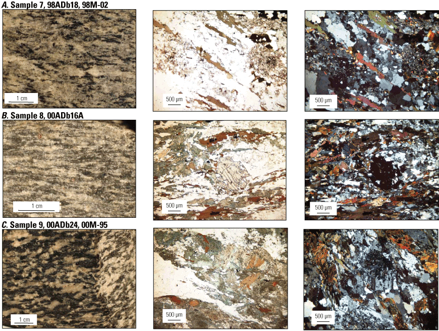
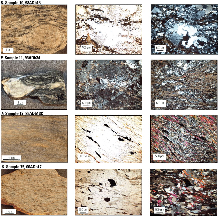
Representative photographs and photomicrographs of selected metaigneous rocks from the Fortymile River assemblage in east-central Alaska analyzed for U-Pb zircon geochronology and whole-rock geochemistry. Sample numbers and field numbers are given. For each sample, the left column shows a photograph of the cut face of the hand sample (duplicate field numbers indicate different samples from the same locality were collected for dating and whole-rock geochemistry) and the middle and right columns show transmitted-light photomicrographs (using either plane-polarized or cross-polarized light) of a thin section cut from the hand sample. A, Sample 7 is a quartz-biotite-plagioclase granodiorite gneiss showing fabric formed by elongate dark biotite and white quartz. Paired plane-polarized-light (middle) and cross-polarized-light (right) photomicrographs show brown biotite (middle) and polycrystalline, elongate, gray quartz grains (right) that recrystallized during metamorphism. The oval area at right edge of photomicrographs is composed of sericite and tiny grains of an epidote-group mineral that may have replaced either feldspar or garnet. B, Sample 8 is a garnet-bearing biotite-hornblende tonalite. Paired plane-polarized-light (middle) and cross-polarized-light (right) photomicrographs show a relict fractured garnet around which the foliation slightly curves. C, Sample 9 is a biotite-hornblende quartz diorite gneiss. Plane-polarized-light photomicrograph (middle) shows green hornblende and brown biotite, elongate white quartzo-feldspathic area, and minor chlorite and epidote group minerals. Cross-polarized-light photomicrograph (right) of a different area of the same thin section shows predominance of plagioclase over quartz; some of the plagioclase laths have cores of finely granular epidote-group minerals indicating a more calcic core. D, Sample 10 is an augen gneiss; hand sample shows biotite, quartz, and plagioclase wrapping around augen. Paired plane-polarized-light (middle) and cross-polarized-light (right) photomicrographs show small augen of polycrystalline quartz and minor potassium-feldspar, around which biotite folia bend, and fine-grained polycrystalline grains of recrystallized quartz. E, Sample 11 is an augen gneiss; hand sample shows elongate tail on potassium-feldspar and small, ovoid quartz and feldspar grains in a dark matrix. Cross-polarized-light photomicrographs from different parts of the thin section show finely fibrous sericite. Fine-grained carbonate, chlorite, and quartz formed during retrograde alteration; dark gray areas (middle image) are potassium-feldspar. F, Sample 12 is a quartz-muscovite schist that we interpret to be a recrystallized metarhyolite. Paired plane-polarized-light (middle) and cross-polarized-light (right) photomicrographs show thin elongate discontinuous trains of black iron-titanium oxide. Left image shows thin muscovite folia (magenta) and fine-grained white quartz. No primary volcanic textures survived metamorphic recrystallization. G, Sample 75 is a quartz-muscovite schist that we interpret as a metarhyolite. Paired plane-polarized-light (middle) and cross-polarized-light (right) photomicrographs show black iron-titanium oxides and minor, brown biotite (middle); fabric-defining muscovite (magenta) and quartz (white and gray) are best seen in cross-polariazed light (right). cm, centimeter; µm, micrometer.
Appendix 2. Representative Photographs and Photomicrographs of Selected Metaigneous Rocks from the Nasina Assemblage, Eastern Alaska and Western Yukon
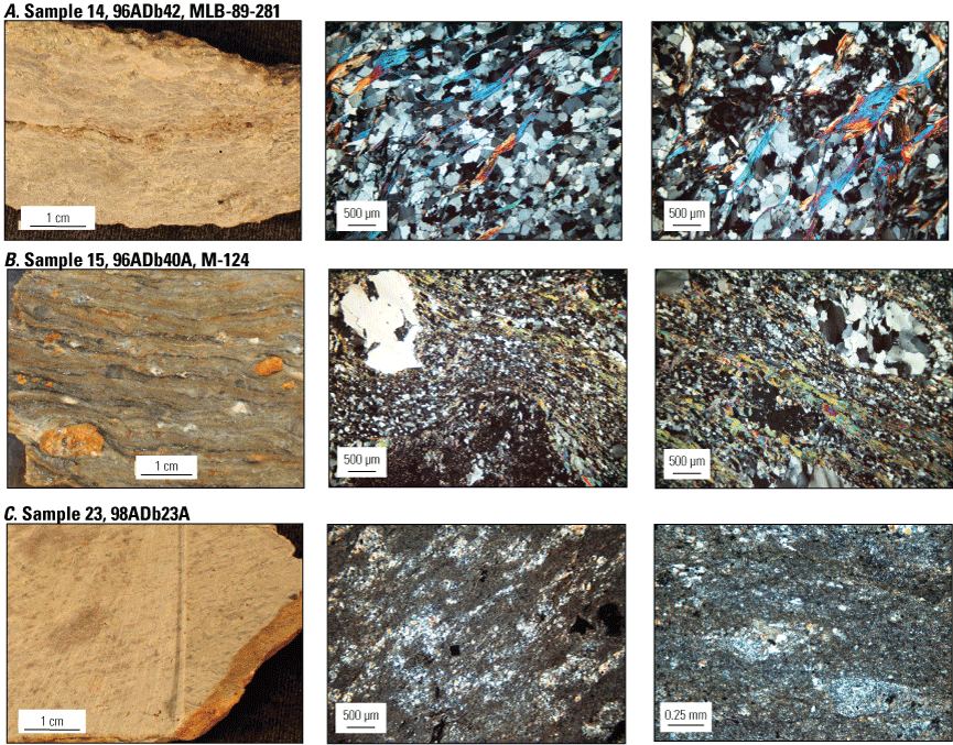
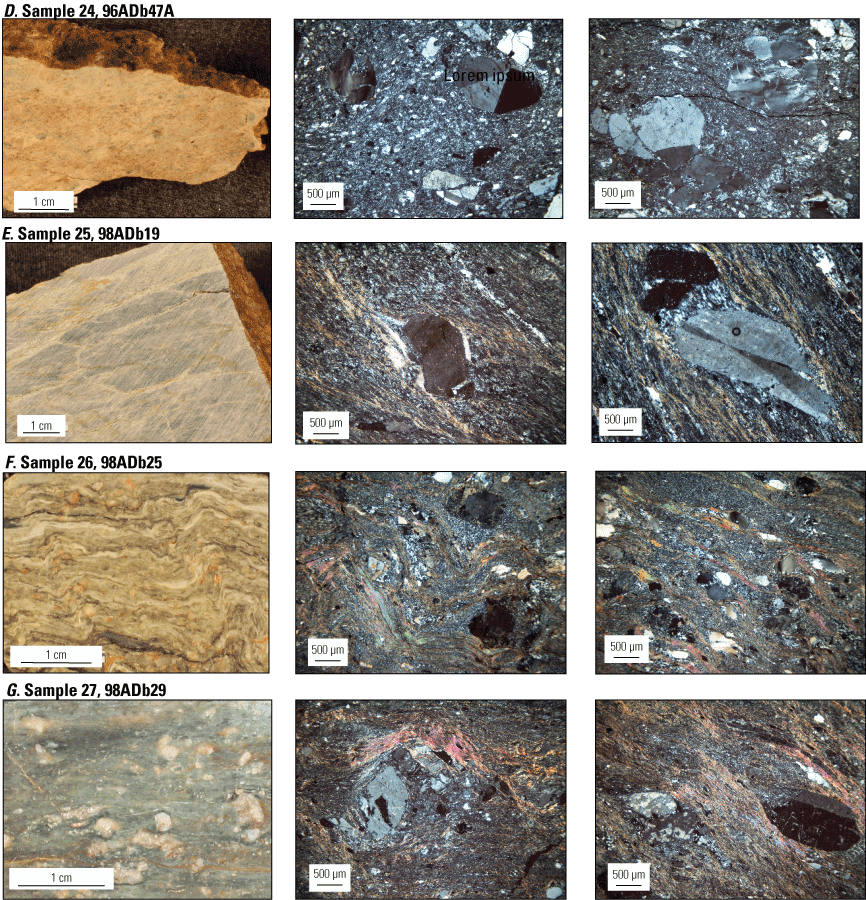
Representative photographs and photomicrographs of selected metaigneous rocks from the Nasina assemblage in east-central Alaska and western Yukon analyzed for U-Pb zircon geochronology and whole-rock geochemistry. Sample numbers and field numbers are given. For each sample, the left column shows a photograph of the cut face of the hand sample (duplicate field numbers indicate different samples from same locality were collected for dating and whole-rock geochemistry) and the middle and right columns show transmitted, cross-polarized-light photomicrographs of a thin section cut from the hand sample. A, Sample 14 is a felsic metatuff showing foliation defined by thin, elongated concentrations of gray quartz and white feldspar. Photomicrographs show very fine-grained annealed quartz and wisps of white mica. Cryptic evidence of relict feldspar phenocrysts are gray, iron-stained patches (center of right image). B, Sample 15 is a felsic metaporphyry showing orange, iron-stained feldspar and white quartz phenocrysts around which a quartz-mica protomylonitic fabric is deflected. Photomicrographs show the fine-grained recrystallized matrix of quartz and white mica. In the middle image, a white quartz phenocryst reveals evidence of former melt inclusions by its irregular outline; the black area at the bottom of the photomicrograph is part of a twinned feldspar. In the right image, the oval-shaped, polygonized quartz porphyroblast in the upper right and the strained (wavy and striped) dark and light gray quartz porphyroblast at the center bottom may have originally been phenocrysts and are evidence of mylonitization. C, Sample 23 is a metarhyolite showing elongate patches of white and light gray minerals identified as probable feldspar and quartz, respectively. Photomicrographs show fine-grained matrix of quartz and feldspar and likely former phenocrysts replaced by finely crystalline quartz, feldspar, and sericite. D, Sample 24 is a metarhyolite showing weakly developed foliation and light gray quartz and white feldspar phenocrysts. Photomicrographs show fine-grained recrystallized matrix of quartz and feldspar and twinned, gray feldspar phenocrysts and white to gray, strained quartz phenocrysts. E, Sample 25 is a metarhyolite showing well-developed foliation. Photomicrographs show fine-grained recrystallized matrix of quartz and sericite enveloping a quartz phenocryst (middle image) and a twinned feldspar (left image). F, Sample 26 is a metarhyolite showing wavy crenulation cleavage formed by thin folia of white quartz, rounded augen of white quartz, and orange iron-stained feldspar. Photomicrographs show fine-grained recrystallized matrix of quartz and sericite folia enveloping mostly white to light gray quartz phenocrysts and dark gray to black feldspar phenocrysts. G, Sample 27 is a metarhyolite showing rotated and rounded white feldspar phenocrysts in a greenish and white fine-grained matrix. Photomicrographs show mylonitic texture with foliation defined by pinkish to bluish sericite and cryptocrystalline quartz that wraps around mylonitized phenocrysts that have cores of relict potassium-feldspar phenocrysts (light gray mineral in left-central part of middle image) and partially replaced margins of microcrystalline quartz. Right image shows an oval polygonized quartz grain (lower left) and a rotated, twinned potassium-feldspar phenocryst (lower right). cm, centimeter; µm, micrometer; mm, millimeter.
Appendix 3. Representative Photographs and Photomicrographs of Selected Metaigneous Rocks from the Ladue River Unit, Klondike Assemblage, Permian Dike, and Seventymile Terrane, Eastern Alaska and Western Yukon
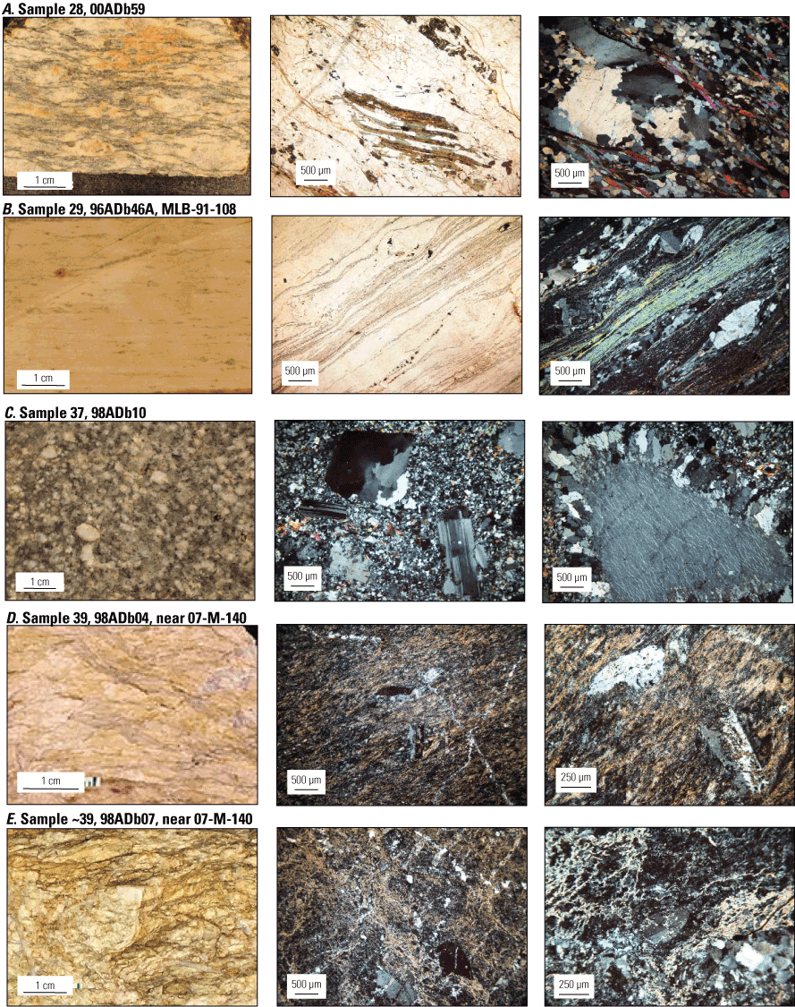
Representative photographs and photomicrographs of selected metaigneous rocks from the Ladue River unit, Klondike assemblage, Permian dike, and Seventymile terrane in east-central Alaska and western Yukon analyzed for U-Pb zircon geochronology and whole-rock geochemistry. Sample numbers and field numbers are given. For each sample, the left column shows a photograph of the cut face of the hand sample (duplicate field numbers indicate different samples from same locality were collected for dating and whole-rock geochemistry) and the middle and right columns show transmitted-light photomicrographs (using either plane-polarized or cross-polarized light) of a thin section cut from the hand sample. A, Sample 28 is a retrograded augen gneiss showing ovoid areas of quartz and potassium-feldspar. Plane-polarized-light photomicrograph shows retrograde replacement of dark brown biotite folia with interlayered green chlorite and white muscovite folia (lower part of middle image) and high-relief secondary epidote granules (upper right). Cross-polarized-light photomicrograph (right image) from a different area of the thin section shows sutured margins of a polycrystalline quartz grain (gray and white) with white mica (magenta) and fine-grained quartz. B, Sample 29 is a quartz-muscovite schist that we interpret to be a recrystallized metarhyolite. Paired photomicrographs show a polysynthetically twinned feldspar grain (phenocryst?) in upper left, a lamina of finely polygonized quartz, a 500-micrometer (µm)-thick layer of white mica (blue interference color), and an ovoid polycrystalline quartz augen (recrystallized quartz phenocryst?) in the lower right. C, Sample 37 is an undeformed granodiorite dike. Cross-polarized-light photomicrographs show two different areas of the thin section. In the middle image, note polysynthetically twinned feldspar laths and a quartz grain (black and gray interference color in upper left) within a fine-grained matrix of quartz, biotite, and muscovite. Right image shows an uncommon corona (rapakivi-like texture) in which an approximately 1.3-millimeter perthitic potassium-feldspar grain is surrounded by a corona composed of a mosaic of small perthite and plagioclase grains. D, Sample 39 is a fine-grained, foliated, quartz-sericite rock. Cross-polarized-light photomicrograph in middle shows a fine-grained, quartz (gray) and sericite (orange) phyllitic matrix that contains several approximately 0.6-millimeter-long twinned feldspar phenocrysts and is crosscut by narrow quartz veins. Higher magnification cross-polarized-light photomicrograph on right shows twinned feldspar laths that indicate a volcanic rather than sedimentary origin for this siliceous unit. E, Sample ~39 (collected near sample 39) is a fine-grained, foliated, quartz-sericite rock. Cross-polarized-light photomicrograph in middle shows fine-grained quartz (light gray), subhedral feldspar (dark gray at bottom), and laminae of sericite (yellowish tan). Higher magnification cross-polarized-light photomicrograph on right shows a different area of the thin section. cm, centimeter; µm, micrometer.
Appendix 4. U-Pb Zircon Analyses
Table 4.1.
Thermal ionization mass spectrometry (TIMS) U-Pb analytical data for zircon and titanite from Paleozoic metaigneous rocks from eastern Alaska and western Yukon.[Digital data available from Dusel-Bacon and Mortensen (2023). Corr. coef., correlation coefficient; Ma; mega-annum; meas., measured; mg, milligram; ng, nanogram; ppm, part per million; s, standard error; σ, standard deviation; uncert., uncertainty]
Capital letter designates the analysis. T1 and T2 designate U-Pb titanite analyses. N# is the degrees of side slope used on the Frantz magnetic separator to attain a separate of non-magnetic zircons. Grain size fraction listed in micrometers; plus sign means the grain size is greater than the value given. Samples marked by asterisks were published by Mortensen (1986). a, abraded; e, elongate prismatic grains; p, stubby prismatic grains; s, single grain was analyzed; t, tips broken off elongate prisms that had visible inherited cores; u, unabraded.
Corrected for spike and fractionation as determined from replicate analyses of National Bureau of Standards common lead standards.
Corrected for blank lead and uranium and initial common lead (Stacey and Kramers, 1975).
Calculated ages were determined using the numerical error propogation method of Roddick (1987) and are given at the 2 standard deviation (σ) level (95 percent confidence interval).
Sample information given in table 2 of main text.
Table 4.2.
Laser ablation inductively coupled plasma mass spectrometry (LA-ICP-MS) analytical data for zircons from Paleozoic metaigneous rocks from the Chicken assemblage (sample 38) and the Seventymile terrane (sample 39) in eastern Alaska.[Ma, mega-annum; s, standard error; uncert., uncertainty; σ, standard deviation]
Crystallization ages for each sample are assigned based on a weighted average of the 206Pb/238U ages of multiple analyses (fig. 10 of main text) and are shown in table 2 and on figure 4 of the main text.
Uncertainty is 1 standard deviation (σ) (68 percent confidence interval) of isotopic age given in preceding column.
Sample information given in table 2 of main text. Analyses were made at the Pacific Centre for Isotopic and Geochemical Research at the University of British Columbia in Vancouver, Canada, using methods as described by Tafti and others (2009).
Appendix 5. Whole-Rock Geochemical Analyses
Table 5.1.
Whole-rock geochemical data for augen gneiss from the Lake George assemblage in the Big Delta, Eagle, and Tanacross quadrangles, east-central Alaska.[Digital data available from Dusel-Bacon and Mortensen (2023). Most data are originally from Dusel-Bacon and Aleinikoff (1985). New results are X-ray fluorescence (XRF) data for Rb, Sr, Y, Zr, Nb, Ba, and Ce (plotted in fig. 14), completed as part of this study. Coordinates are relative to the North American Datum of 1983 (NAD 83). Quadrangle (quad.) names are abbreviated as follows: BD, Big Delta; EA, Eagle; TA, Tanacross. Individual 1:63,360-scale quadrangle designations follow quadrangle names. LOI, loss on ignition; REE, rare earth element; —, not determined]
Table 5.2.
Whole-rock major-element geochemical data for amphibolites from Dusel-Bacon and Cooper (1999); location information has been added.[Digital data available from Dusel-Bacon and Mortensen (2023). Coordinates are relative to the North American Datum of 1983 (NAD 83). Quadrangle (quad.) names are abbreviated as follows: BD, Big Delta; EA, Eagle; FB, Fairbanks; TA, Tanacross. Individual 1:63,360-scale quadrangle designations follow quadrangle names. loc., location; LOI, loss on ignition]
Location number from Dusel-Bacon and Cooper (1999).
Table 5.3.
Whole-rock trace-element geochemical data for amphibolites from Dusel-Bacon and Cooper (1999).[Digital data available from Dusel-Bacon and Mortensen (2023); see table 5.2 for location information. <, less than; —, not determined]
Abbreviations
E-MORB
enriched midocean ridge basalt
Ga
giga-annum
HFSE
high field strength element
ID-TIMS
isotope dilution thermal ionization mass spectrometry
kbar
kilobar
LA-ICP-MS
laser ablation inductively coupled plasma mass spectrometry
LREE
light rare earth element
Ma
mega-annum
MSWD
mean squared weighted deviation
N-MORB
normal midocean ridge basalt
REE
rare earth element
SHRIMP
sensitive high-resolution ion microprobe
Moffett Field Publishing Service Center, California
Manuscript approved February 25, 2024
Edited by Monica Erdman
Illustration support by JoJo Mangano and Kimber Petersen
Layout by Kimber Petersen
Disclaimers
Any use of trade, firm, or product names is for descriptive purposes only and does not imply endorsement by the U.S. Government.
Although this information product, for the most part, is in the public domain, it also may contain copyrighted materials as noted in the text. Permission to reproduce copyrighted items must be secured from the copyright owner.
Suggested Citation
Dusel-Bacon, C., and Mortensen, J.K., 2024, New U-Pb geochronology and geochemistry of Paleozoic metaigneous rocks from western Yukon and eastern Alaska, cross-border synthesis, and implications for tectonic models (ver. 1.1, December 2024): U.S. Geological Survey Professional Paper 1888, 100 p., https://doi.org/10.3133/pp1888.
ISSN: 2330-7102 (online)
Study Area
| Publication type | Report |
|---|---|
| Publication Subtype | USGS Numbered Series |
| Title | New U-Pb geochronology and geochemistry of Paleozoic metaigneous rocks from western Yukon and eastern Alaska, cross-border synthesis, and implications for tectonic models |
| Series title | Professional Paper |
| Series number | 1888 |
| DOI | 10.3133/pp1888 |
| Edition | ver. 1.0: September 4, 2024; ver. 1.1: December 16, 2024 |
| Publication Date | September 04, 2024 |
| Year Published | 2024 |
| Language | English |
| Publisher | U.S. Geological Survey |
| Publisher location | Reston, VA |
| Contributing office(s) | Geology, Minerals, Energy, and Geophysics Science Center |
| Description | Report: vi, 100 p.; Data Release |
| Country | Canada, United States |
| State | Alaska |
| Other Geospatial | Yukon |
| Online Only (Y/N) | Y |