

Determining Volcanic Risk in Auckland (DEVORA) Research Programme—A Transdisciplinary Approach to Address the Challenge of Distributed Volcanism in an Urban Environment
Links
- Document: Report (2.8 MB pdf) , HTML , XML
- Larger Work: This publication is Chapter B of Distributed volcanism—Characteristics, processes, and hazards
- Download citation as: RIS | Dublin Core
Acknowledgments
The DEtermining VOlcanic Risk in Auckland (DEVORA) Research Programme is funded by the Aotearoa New Zealand Natural Hazards Commission Toka Tū Ake (NHC) and Te Kaunihera o Tāmaki Makaurau Auckland Council, and we are immensely grateful to our funding partners for their long-term and ongoing support. We would like to especially acknowledge Dr. Hugh Cowan, former General Manager of Reinsurance, Research, and Education at NHC, who worked tirelessly with us in the early stages to get the program up and running. We thank all the stakeholders, partners, researchers, students, interns, research assistants, and overseas collaborators who have contributed to making the program a success. We are grateful to reviewers Wendy Stovall, Beth Bartel, and Micol Todesco for their thorough reviews that improved the quality of our manuscript. Finally, we thank our colleagues at the U.S. Geological Survey for the editorial assistance, and for inviting us to contribute a manuscript to this important volume.
Abstract
The Determining Volcanic Risk in Auckland (DEVORA) Research Programme was launched in 2008 to address the challenges associated with monogenetic volcanism in an urban setting and to enhance volcanic risk management in Tāmaki Makaurau Auckland in Aotearoa New Zealand. It is a multi-agency, increasingly transdisciplinary (defined here as research that transcends traditional disciplinary boundaries by integrating diverse types of knowledge, perspectives, and methods from academic and non-academic participants to create novel solutions to complex problems), and collaborative research program jointly led by Waipapa Taumata Rau University of Auckland and Earth Sciences New Zealand (ESNZ; formerly GNS Science), with core funding from Natural Hazards Commission Toka Tū Ake (NHC; formerly the Earthquake Commission, EQC) and Te Kaunihera o Tāmaki Makaurau Auckland Council (AC). The primary research focus of DEVORA is to investigate the geologic history, volcanic hazards, and risk posed by the basaltic intraplate Auckland Volcanic Field. Disruption from ash fall and gas from other Aotearoa New Zealand volcanoes is also considered. DEVORA’s work to explore exposure and vulnerability in Tāmaki Makaurau Auckland is also useful for assessing risks from other non-volcanic natural hazards, such as seismic and tsunami hazards. The greater Tāmaki Makaurau Auckland region has an ethnically and socio-economically diverse population of approximately 1.7 million, representing about one-third of the Aotearoa New Zealand population, and hosts critical infrastructure of national significance. The size and nature of the populace, consequential economic base, and important infrastructure within Tāmaki Makaurau Auckland mean that the effects of a volcanic eruption would be felt nationally, including through the disruption of air travel to Aotearoa New Zealand. The hazards from such an eruption could potentially affect hundreds of thousands of people, businesses, and lifelines (critical infrastructure). A considerable challenge for emergency and risk managers is the monogenetic nature of the volcanic field. It is not known where or when the next eruption will occur, how much warning we may get before an eruption, nor how an eruption and its effects might unfold. In this contribution, we highlight the concept and collaborative intent of the DEVORA Programme and show how it has evolved over the 16 years since its inception. We describe how DEVORA has unified more than 100 researchers (including more than 50 graduate students) and numerous stakeholders to address key issues facing Tāmaki Makaurau Auckland and describe how research findings are being implemented into policy and communicated to stakeholder agencies and the public. We also illustrate the broader influence of the DEVORA Programme and provide some learnings that might benefit others embarking on similar integrated projects, especially those focused on distributed volcanism in and near populated areas.
Introduction
The basaltic intraplate Auckland Volcanic Field lies beneath the urban environment of Tāmaki Makaurau Auckland. It is an area of distributed volcanism characterized by approximately 53 small monogenetic volcanoes in the form of scoria cones, maars, craters, and a small shield volcano (Rangitoto) that have formed over the past 193,000 years (fig. 1A–E). Seismic velocity tomography and geochemistry suggest a primary mantle source region at depths of 70–90 kilometers (km) (Horspool and others, 2006) from which melts are thought to ascend rapidly to the surface with little crustal interaction (McGee and others, 2013, 2015; Brenna and others, 2018). More than 80 percent of past eruptions began with a phreatomagmatic phase, forming maars and tuff rings (Kereszturi and others, 2014), with tephra fall, base surges, and ballistic projectiles as the main hazards. Where present, subsequent magmatic phases formed scoria cones and, in most cases, lava flows. Ages of 47 of the 53 volcanic centers thus far identified reveal that the field’s first volcano (Pupuke volcano) erupted approximately 193 thousand years ago (ka), and the last (Rangitoto volcano) erupted about 500 years before present (where present is A.D. 1950) (Leonard and others, 2017). These geochronological constraints indicate repose periods of less than 0.1–13 thousand years, which have decreased since ~60 ka. Our current conceptual geological model of the Auckland Volcanic Field is summarized in a review paper by Hopkins and others (2021).
In 2023, the greater Tāmaki Makaurau Auckland region had an estimated permanent population of 1.7 million (Stats, N.Z.–Tatauranga Aotearoa, 2023), representing approximately one-third of the total Aotearoa New Zealand population. This population is ethnically diverse; in 2023, 51 percent of people living in the Tāmaki Makaurau Auckland region were born overseas compared with 29 percent for Aotearoa New Zealand as a whole, 50 percent of Aucklanders were non-European compared to the rest of Aotearoa New Zealand at 32 percent, and 12 percent of Aucklanders identified as Māori (Stats, N.Z.–Tatauranga Aotearoa, 2023). Tāmaki Makaurau Auckland is a key economic center; in 2023 it contributed 38 percent to Aotearoa New Zealand’s Gross Domestic Product (Stats, N.Z.–Tatauranga Aotearoa, 2024) and it is the base for several facilities of national significance (for instance, Auckland airport and seaport; fig. 1A). The national electricity grid passes through Tāmaki Makaurau Auckland (fig. 1A), so if electricity transmission is fully disrupted in Tāmaki Makaurau Auckland, no electricity will be transmitted north of Tāmaki Makaurau Auckland (Deligne and others, 2017a).
The large and diverse population, consequential economic base, and important infrastructure within Tāmaki Makaurau Auckland mean that disruption because of a volcanic eruption would be nationally consequential. The hazards from such an eruption could affect hundreds of thousands of people, businesses, and critical infrastructure. The uncertainties in timing and location of a future eruption in Tāmaki Makaurau Auckland make emergency and risk management challenging. The main incentive for stakeholders to continue to support research into the Auckland Volcanic Field is the expectation that it will:
-
1. Provide the information needed to understand and reduce these uncertainties;
-
2. Guide how to manage and communicate the remaining uncertainties;
-
3. Ensure the ongoing availability of specialist advice by developing local expertise and keeping these experts in Tāmaki Makaurau Auckland.
In this paper, we highlight the structure and processes of the DEtermining VOlcanic Risk in Auckland (DEVORA) Programme and show how it has evolved over the 16 years since its inception. We describe how DEVORA has unified more than 100 researchers, including ~50 graduate students and numerous stakeholders to address key issues facing Tāmaki Makaurau Auckland and how research findings are being implemented into policy and communicated to stakeholder agencies and the public. We also illustrate the broader influence of the DEVORA Programme and provide some learnings that might benefit others embarking on similar integrated projects, especially in areas of distributed volcanism.
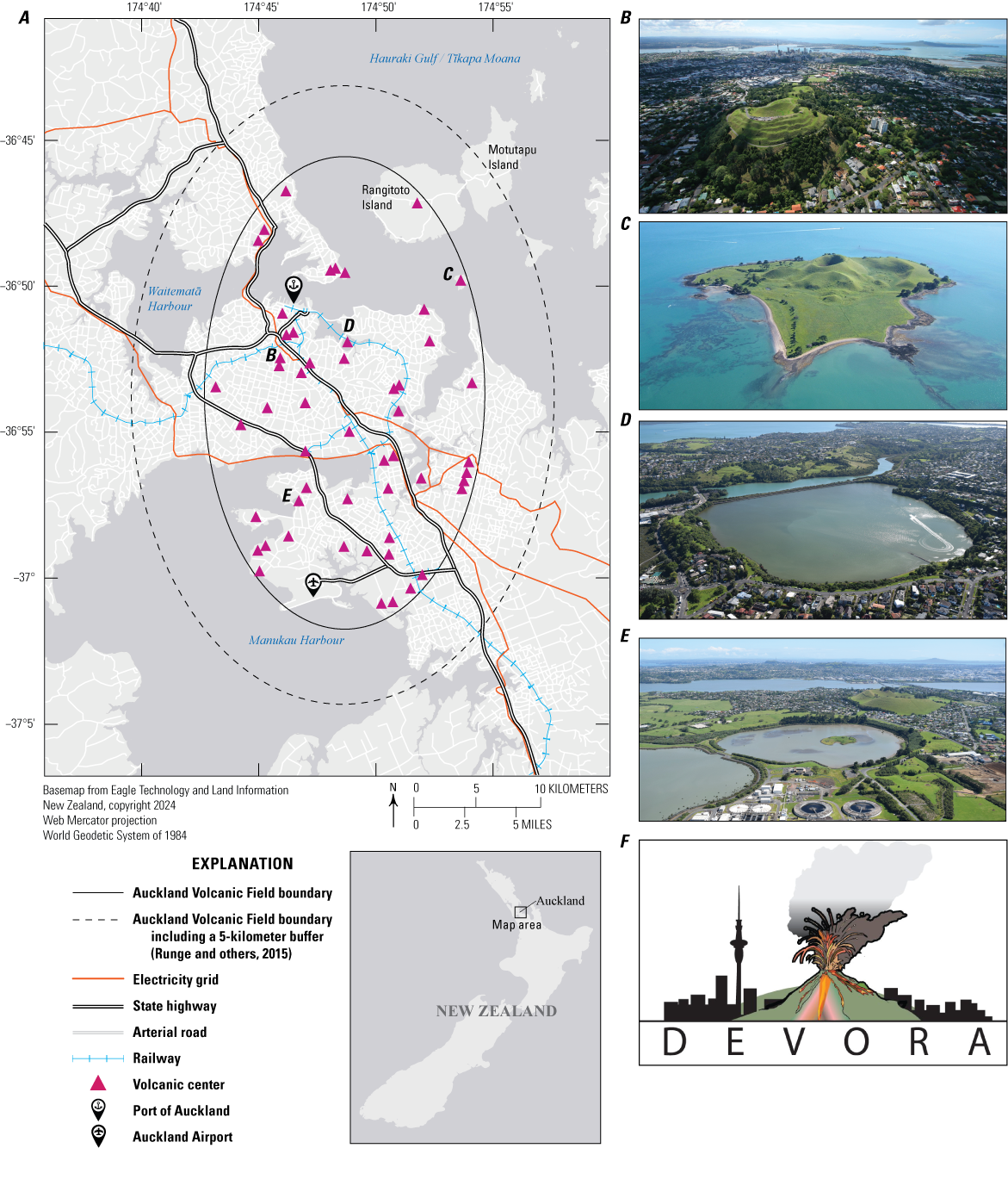
A, Map of the Auckland Volcanic Field showing the “tight” boundary (identified by drawing an ellipse encompassing all existing vents) and a 5-kilometer buffer boundary (proposed by Runge and others [2015] to account for source uncertainty and the possibility that future dikes might propagate and erupt beyond the boundary defined by existing vents). Electricity grid, railway, and roads in the area are also shown. Inset shows the location of the Auckland Volcanic Field in the North Island of Aotearoa New Zealand. B, Aerial photograph of central Tāmaki Makaurau Auckland with Maungawhau/Mount Eden in the foreground and Rangitoto Island in the right background. Photograph reproduced with permission from Auckland Council. C, Aerial photograph of Motukorea/Browns Island. D, Aerial photograph of Ōrākei Basin. E, Aerial photograph of Māngere Lagoon with Te Pane o Mataoho/Māngere Mountain in the background. Photographs C-E by Bruce W. Hayward, 2018, used with permission. F, The DEVORA Programme logo.
History of the DEVORA Programme
Before DEVORA’s inception in 2007–08, research on the Auckland Volcanic Field was undertaken on an ad hoc, uncoordinated basis and was limited in scope owing to the interests of individual researchers. At that time, only 49 volcanoes were recognized within the Tāmaki Makaurau Auckland area, and most had not been dated or studied in detail. Although the main potential hazardous phenomena associated with a future Auckland Volcanic Field eruption had been identified, little was known about past patterns in activity or potential consequences of an eruption.
Discussions about establishing a research project focused on the Auckland Volcanic Field began in late 2006, prompted in part by the successful initiation in the same year of a (still ongoing) multi-disciplinary project based in the capital city of Wellington, Aotearoa New Zealand, focusing on the earthquake hazard and risk from the Wellington Fault. It was called “Wellington It’s Our Fault” and was later renamed to “It’s Our Fault” (Van Dissen and others, 2010). The project, funded by the then Earthquake Commission (EQC; now Natural Hazards Commission), aimed to make Wellington a more resilient city through a comprehensive study of the likelihood of large earthquakes and their effects on humans and the built environment (refer to https://www.itsourfault.org.nz/ for more information). The development of a similar project in Tāmaki Makaurau Auckland was brainstormed in 2007, initially entitled “Auckland: It’s our Volcano.” The uniqueness of these two research programs was that they were designed in collaboration with the EQC, who was the primary funder, they involved scientists from both a government agency (GNS Science) and universities (Victoria University of Wellington and the University of Auckland [UoA]); they involved key stakeholders (for example, from local government) from the outset; and they were deliberately designed as end-to-end science-to-society projects, in the sense that their scope ranged from geological history, through hazards, to risk. This was uncommon in the natural hazard research landscape in Aotearoa New Zealand at the time.
It soon became clear that “Auckland: It’s Our Volcano” did not have the same clever ring to it as its sister project focused on Wellington. So, the Auckland project was soon renamed “DEtermining VOlcanic Risk in Auckland” (DEVORA) by its two inaugural co-leaders, Jan Lindsay (UoA) and Gill Jolly (Earth Sciences New Zealand [ESNZ], formerly GNS Science), and a logo was developed (fig. 1F). The name DEVORA originated as a strong female name meaning “honeybee” in Hebrew. On reflection, the research program has certainly lived up to the original meaning of its name, having had strong female involvement from the beginning and embodying the values of industriousness, teamwork, and community building of the honeybee.
The newly named DEVORA Programme was launched outside the “Volcanoes” exhibit at Auckland Museum in 2008 (fig. 2). It was initially set up as a seven-year project, with funding provided by EQC Toka Tū Ake, now the Natural Hazards Commission (NHC; $NZ 200,000 per year) from the outset, with Auckland Council (AC) coming on board as a funder in 2010 ($NZ 100,000 per year). At the end of the first seven years, the project was extended for a further five-year period, with the work program and funding being renewed annually. Funding remained constant at $NZ 300,000 per year until 2016, when a new EQC workstream emerged, allowing the program leaders to propose that DEVORA’s core volcanic impact and risk work be supported via a separate EQC fund. The proposal was successful, and this $NZ 75,000–135,000 per year “volcanic loss” initiative has since become its own offshoot project, initially as part of DEVORA and, since 2021, as an independent but strongly connected project called: “Catalysing a National Volcanic Hazard and Risk Model framework,” led out of the University of Canterbury. This project explores probabilistic volcanic risk across the whole country and includes a volcanic loss modeling pilot in Tāmaki Makaurau Auckland. In 2023, the NHC Toka Tū Ake contribution to DEVORA was increased by $NZ 85,000 to $NZ 285,000 per year, bringing the total to $NZ 385,000 per year. In July 2021, DEVORA moved to a three-year funding cycle to align with Auckland Council’s budget cycle.
DEVORA is also supported by a large amount of in-kind and co-funding; indeed, at least the same amount (about $NZ 300,000 per year) is estimated to come from co-funding from a range of sources, including the University of Auckland (for instance, professional time for the co-leader as well as several doctoral scholarships); ESNZ (professional time for the co-leader; development work on RiskScape, an open-source spatial data processing application used for multi-hazard risk analysis in Aotearoa New Zealand; Paulik and others, 2023); NHC Toka Tū Ake (through contestable processes, such as various postgraduate scholarships, postdoctoral fellowships and aligned research projects, as well as support for RiskScape development), and various aligned research projects.
Each funding body has different requirements to justify the ongoing delivery of funding for the project. The DEVORA team provides support and collateral to enable these key partners to develop the business cases required to secure constant funding at the appropriate intervals.
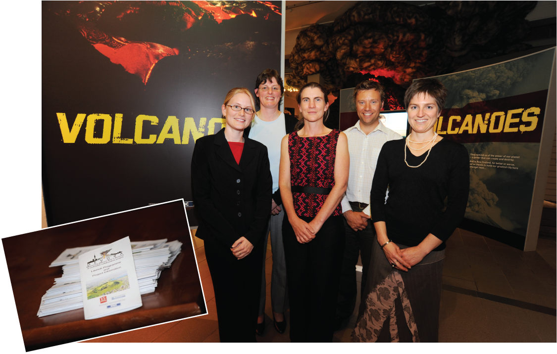
Photograph of the inaugural DEVORA leadership team at the official program launch at Auckland Museum, November 6, 2008. From left to right: Elaine Smid (founding and current project manager, University of Auckland), Gill Jolly (founding co-leader, Earth Sciences New Zealand [ESNZ]), Jan Lindsay (founding and current co-leader, University of Auckland), Graham Leonard (current co-leader, ESNZ), and Hannah Brackley (founding project manager, Wellington City Council; formerly GNS Science). Inset shows the launch booklet.
Structure of the DEVORA Programme
Project Management and Role of the Steering Committee
DEVORA has two co-leaders, one from the University of Auckland and one from Earth Sciences New Zealand. This joint leadership model has proven successful—it has enabled the project to draw on expertise from both organizations and to oversee a wide range of aligned projects. A decision was made at the beginning that a project manager would be essential to facilitate DEVORA running smoothly, and this role has been filled at 0.3–0.5 full time equivalent since project inception. The project manager plays a vital role in the project, by (1) tracking the progress of work packages (~60 at any one time) and writing progress reports; (2) developing the annual plan and budget; (3) managing the DEVO-RA (Research Assistant) team; (4) communicating with our stakeholders; (5) organizing research forums and steering committee meetings; (6) supporting DEVORA researchers in their requests for resources; (7) maintaining file repositories and research databases; (8) managing communications including the DEVORA website, social media, email distribution list; and (9) managing program outreach. At any time, DEVORA has between two and four research assistants/interns who assist the project manager with all the tasks described above. In 2023, a new position was created within DEVORA, entitled “Manutaki” (after the Māori word for the sentry bird within a flock), to guide the DEVORA team on its journey to become culturally responsive researchers and leaders meaningfully engaging with Māori. Collectively, the two co-leaders, the project manager, the Manutaki, and the senior research assistants are referred to as the DEVORA management team.
The DEVORA Steering Committee guides the project’s direction and decision-making. It is the vehicle through which participants manage their relationship with the DEVORA Programme and oversee the delivery of the program, following the Head Agreement (the overarching DEVORA agreement between the four main parties: NHC Toka Tū Ake, Auckland Council, UoA, and ESNZ). The steering committee comprises, at a minimum, representatives from these four parties, with the representatives from the science organizations (UoA and ESNZ) not directly involved in the DEVORA Programme. Other representatives have been invited to join the steering committee over the years. There is currently additional representation from Auckland Emergency Management (AEM; formerly called Auckland Civil Defense and Emergency Management), Massey University, the aligned Resilience to Nature’s Challenges National Science Challenge (RNC),1 and the Tūpuna Maunga Authority (TMA), who govern and manage volcanic landscapes in Tāmaki Makaurau Auckland on behalf of Tangata Whenua (representing the Indigenous people of Tāmaki Makaurau Auckland) and the people of Tāmaki Makaurau Auckland. Members of the DEVORA management team organize and attend steering committee meetings to provide progress reports and to receive feedback and guidance. The DEVORA Steering Committee meets with the DEVORA management team twice a year; once in November after the annual research forum and once in April or May to review the upcoming year’s work plan, which takes effect on July 1 of each year.
One of 11 National Science Challenges established in 2014 to tackle the biggest science-based issues and opportunities facing New Zealand.
Evolution of Research Questions and Objectives
The development of the detailed DEVORA work program between 2006 and 2008 was informed by, among other work, the outcomes of Exercise Ruaumoko, a 2007–08 central-government-led Aotearoa New Zealand Civil Defence exercise simulating the lead-up to an Auckland Volcanic Field eruption. As such, the DEVORA work program systematically addressed knowledge gaps revealed by the exercise (Horrocks, 2008). In the very early stages, a comprehensive review was undertaken of past work in several key areas, namely petrology (Smith and others, 2009), structure (Irwin, 2009), ages (Lindsay and Leonard, 2009), risk and social data (Daly, 2009), and statistical methods for hazard assessment (Smid and others, 2009). These reviews highlighted gaps and made recommendations for future work that were subsequently built into the work program. The work program thus developed was initially organized into three themes (fig. 3), with research within each “model” shaped by a series of key questions:
-
1. Geological model
-
• Where is Auckland Volcanic Field magma coming from?
-
• Why does it leave its source?
-
• What controls the path of magma in the crust?
-
• Where will the magma reach the surface?
-
• What is the crust underlying the Auckland Volcanic Field made of?
-
• Why is the most recent eruption the largest?
-
• How fast will magma travel to the surface?
-
• When will we detect the ascending magma?
-
-
2. Probabilistic volcanic hazard model
-
• What is the distribution in time of past eruptions affecting Auckland?
-
• What is the likelihood and size of future eruptions affecting Auckland?
-
• What are the likely styles and hazards of future eruptions?
-
• Where are we in the lifespan of the Auckland Volcanic Field?
-
• How do we usefully calculate probabilistic volcanic hazard for Auckland?
-
• What is the probabilistic volcanic hazard?
-
• How intensive should the monitoring be to provide adequate warning of an Auckland Volcanic Field eruption?
-
-
3. Risk and social model for Auckland
-
• Who and what are exposed to volcanic hazards in Auckland?
-
• How will each hazard affect people and infrastructure?
-
• How will people and organizations cope in an eruption?
-
• What are the nationwide follow-on effects of an eruption affecting Auckland?
-
• How can we calculate risk to people and infrastructure?
-
• What are the risks to people and infrastructure?
-
• How can these risks be reduced?
-
• How can people and organizations prepare to respond effectively to warnings?
-
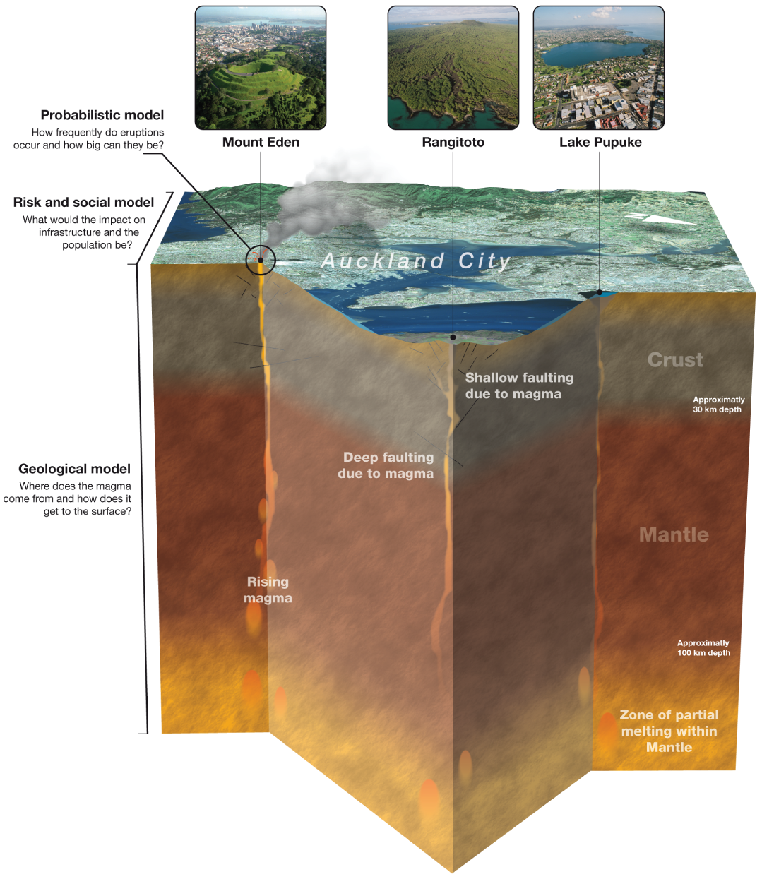
Schematic diagram describing the three main work programs during the first seven years of the DEVORA Programme. From Lindsay and Jolly (2008). Mount Eden is now known as Maungawhau/Mount Eden.
After the first seven years of DEVORA (which we now call Phase 1), the management team took the opportunity to revise the structure of the program and develop a new planning and strategy framework. A new suite of goals to frame the work plan was developed through workshops with the program’s funding partners over a year; this followed an outcome-focused approach emerging in large research programs in Aotearoa New Zealand. In 2015, a new five-year rolling planning cycle began for the DEVORA Programme (Phase 2). Whereas the Phase 1 research plan worked toward an initial risk model, moving sequentially from geology through hazard to risk, Phase 2 allowed improvement of geological, hazard, and risk knowledge and functionality at any time, as new research needs or opportunities arose. The new work plan was based on 11 numbered Outcome Statements (a list of associated secondary outcome statements and milestones can be found in document 1 of Lindsay and others, 2026):
-
1. We are confident in knowing the Auckland Volcanic Field.
-
2. Our diverse society knows, understands, and trusts our science.
-
3. People will behave appropriately in a volcanic crisis.
-
4. People understand and appropriately mitigate risks and consequences in language/formats that suit their needs.
-
5. Auckland Council, businesses, and individuals have anticipated, prepared for, and can respond to and recover from [an Auckland Volcanic Field eruption] through appropriate planning.
-
6. DEVORA supports “Resilient Auckland” (name of the Auckland Civil Defence and Emergency Management [CDEM] Group Plan, 2016–2021. For more information, refer to https://www.aucklandemergencymanagement.govt.nz/about-us/governance/).
-
7. Auckland continues to thrive following any New Zealand eruption.
-
8. Our science has broader benefits.
-
9. Auckland is linked to other major hazard programs aligned to DEVORA.
-
10. We are confident in knowing other volcanic threats to Auckland.
-
11. We have a strong partnership with Māori, supporting Māori aspirations.
Workshops and meetings with stakeholders in 2024 and 2025 explored how well these aspirational outcomes are meeting the needs of DEVORA stakeholders, leading to further refinement. The research program’s aspirational outcomes are now (from June 2025) synthesized as:
-
1. Local government (Auckland Council) and other agencies are using robust physical and social science to make risk-informed decisions (for example, on land use planning, emergency management) as they apply to volcanic risk.
-
2. Volcanic hazard models have been developed, are in formats that can be easily updated with new findings, and are informing impact and risk assessments.
-
3. We have a strong ongoing partnership with Māori, supporting Māori aspirations.
-
4. Capability has been (and is continuously being) developed so that stakeholders and funding partners have access to a strong pool of expertise on volcanic risk in Auckland.
-
5. Sustained science communication ensures the diverse Auckland public is aware of volcanic risk associated with volcanic hazard from both local and distal sources and is making risk-informed decisions. Our communication builds trust in our scientists and sets expectations for delivering authoritative information during a crisis. A varied suite of high-quality information products is available for rapid distribution in the event of a crisis.
-
6. DEVORA maintains and advocates for strong linkages, connections and information sharing within the natural hazard and resilience research and practice sector.
The list of past and present outcome statements can be found in document 1 of Lindsay and others (2026).
Annual Workflow and Project Prioritization Process
Since its inception, the DEVORA Programme has approximately followed the same annual workflow (fig. 4) based on the funders’ financial year, which is July 1 to June 30, and incorporates two Steering Committee meetings and four Quarterly Reports (see document 2 of Lindsay and others [2026] for an example of a Quarterly Report). Between January and May, the project management team prepares a draft budget and work plan based on ideas and priorities that have emerged over the past year at meetings, workshops, and research forums (fig. 4). The draft work plan is presented at a Steering Committee meeting in April–May. The work plan and budget are discussed, and any feedback is incorporated into the final work plan, which is then presented as an annual statement of work. This document tables all the work packages for the coming year (document 3 of Lindsay and others [2026]), is signed by all parties, and forms the basis for contracting. Contracting arrangements have also remained the same throughout the project. ESNZ holds the main contracts with NHC Toka Tū Ake and Auckland Council and subcontracts UoA for their contribution. ESNZ or UoA subcontracts other parties (for instance, other universities).
In October–November each year, DEVORA hosts its annual research forum (in recent years dubbed the “DEVORUM”—a contraction of “DEVORA Forum”) in Tāmaki Makaurau Auckland (see document 4 of Lindsay and others [2026] for an example of a DEVORUM program). On occasion, we jointly host the forum with other organizations (such as Auckland Council) or research programs (such as RNC). This forum provides a valuable opportunity for stakeholders to come together with researchers to discuss the latest findings and for students to present their work in a supportive setting. Forum attendance has grown from ~40 people in the early years to more than 90 more recently (especially after introducing the option to attend virtually in 2020), with representatives from a variety of emergency management, critical infrastructure, and scientific organizations, as well as other stakeholders from across the country. Workshops with stakeholders are sometimes held at the same time as the forum or during other geoscience meetings. At the 2023 DEVORUM, for example, DEVORA researchers worked with AEM to co-host a workshop focused on reviewing the Auckland Volcano Contingency Plan (document 4 of Lindsay and others [2026]). Previous workshops covered topics such as novel monitoring techniques (Deligne and others, 2019) and the volcanic-tectonic connection in Tāmaki Makaurau Auckland (Smid and Howe, 2018).
A key feature of every DEVORUM is a discussion session at the end of the conference program, during which stakeholders can ask questions directly to researchers and communicate their priorities. Leaders prompt participants to identify research gaps and exciting new research directions or priorities. These ideas, together with all other ideas that are identified during the year, are captured in a “Master Ideas Spreadsheet” (fig. 4), where they are given a number. In March 2025, this master ideas spreadsheet contained 414 entries: 263 represented completed projects, 51 were ongoing, and 100 were project ideas. Each year, depending on budget availability and stakeholder priorities, a subset of these new ideas is brought into the annual work plan, which includes a mixture of ongoing and new projects.
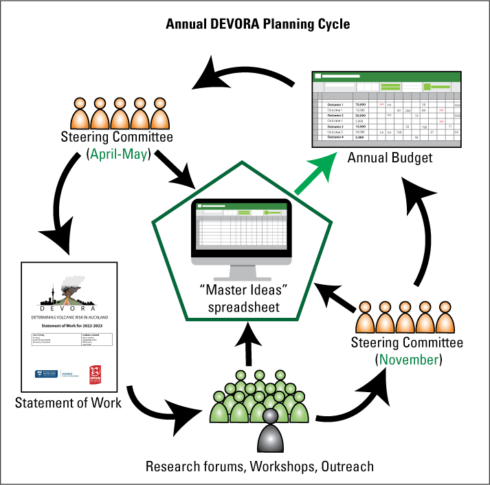
Image showing the annual DEVORA planning cycle.
Outreach and Public Engagement
In order to have a wide outreach, DEVORA employs a variety of communication approaches. Since Phase 2 of DEVORA began in 2015, an Outreach Coordinator (a research assistant) who works to communicate science to the public via various events and engagements has been appointed. The DEVORA team collaborates with schools, museums, and other local community organizations and has developed linkages with other hazard research programs to strengthen partner relationships. At a face-to-face level, the DEVORA outreach group – comprising the Outreach Coordinator and the other research assistants – engages with the public in various ways depending on the target audience’s age and experience and the event’s purpose. Outreach is done at no cost to the requestor, but the number of events the Outreach Coordinator can take on is limited. As such, a strategy has been developed to define which requests are prioritized (document 5 of Lindsay and others [2026]). The largest numbers of people are reached through working with other organizations and participating in events that up to a few thousand people attend, such as the Auckland Heritage Festival (refer to https://ourauckland.aucklandcouncil.govt.nz/heritage-festival/heritage-festival-events/ for more information), and the Museum of Transport and Technology’s Science, Technology, Engineering, and Mathematics (STEM) Fair. In the past, DEVORA researchers and research assistants have given talks, visited classrooms, and led field trips for dozens of schools and organizations. School visits include demonstrations and experiments that get children and their guardians excited about volcano science and teach them how volcanoes work in individual classrooms or for entire year groups. For older students and adult groups, such as Rotary and Lions clubs, Hospice, or other local organizations, DEVORA researchers give presentations about specific subjects; previous examples include the Auckland Volcanic Field or volcanic hazards in Tāmaki Makaurau Auckland. A manual for outreach activities has been prepared (document 6 of Lindsay and others [2026]). Dozens of field trips have been led to Rangitoto Island and around the Auckland Volcanic Field for schools and academic conferences. The target audiences for these field trips included volcanologists, mineralogists, and earthquake engineers (including a pre-conference field trip for the 2023 International Association of Volcanology and Chemistry of the Earth’s Interior [IAVCEI] Scientific Assembly in Rotorua; Smid and others, 2023). So far, more than 95 outreach engagements with the public of Tāmaki Makaurau Auckland have occurred through DEVORA efforts.
DEVORA has an active website,2 Facebook page,3 and Instagram page.4 Regular posting, especially of our popular “#VolcanoMonday” posts, has increased interactions on the DEVORA Facebook page, which had 1,170 followers as of July 2025. Since its launch in mid-2015 until the start of 2025, posts on the DEVORA Facebook page have cumulatively reached more than 130,000 people, with around 7,750 total post interactions (likes/reactions, shares, comments). A 2023 post on Auckland Volcanic Field lava tubes reached more than 23,500 unique people and had 303 reactions, 56 comments, and 23 shares. The DEVORA Instagram page, which had 93 total followers as of July 2025, was launched at the start of 2024 to increase the program’s demographic reach. DEVORA also communicates science through a series of fact sheets, each describing an element of volcanism and related research in the Auckland Volcanic Field. These are distributed at outreach events, posted to the Facebook page, and are available on DEVORA’s website (figs. 5 and 6). When DEVORA reached its 10th anniversary in 2018, the research team celebrated by hiring a graphic artist to help develop a commemorative tea towel, which was distributed to all participants at that year’s annual forum (fig. 7). The artwork on the tea towel created such a favorable impression that the services of the illustrator were retained to collaborate on Fact Sheets. This demonstrates how working alongside non-volcanologists and people with diverse backgrounds, such as illustrators, can help DEVORA’s mission to make research more accessible to diverse audiences and build wide awareness of the Auckland Volcanic Field and its hazards.
A Communications Plan and Media Guide has been developed for the DEVORA Programme, which outlines communication pathways and tips and tricks for engaging with the media (document 7 of Lindsay and others [2026]). A “media alert” system has been created to notify the program’s partners of research that may be of public interest or for when the media calls unexpectedly. This provides the necessary information to prepare DEVORA’s partners for the media attention that may follow. Press releases about DEVORA research are also prepared when key publications come out, and these often lead to public engagement through the media, including interviews and appearances in documentary films, television, news radio, and print. Since its inception, DEVORA Programme research has appeared in around 200 television news segments, newspaper articles, radio shows, and other press. The Communications Plan and Media Guide was recently updated to include guidance on open access publishing. It describes how DEVORA researchers are expected to publish their research findings in open-access formats and outlines how DEVORA has set aside funds to pay the associated journal fees for key papers produced by DEVORA-funded researchers, particularly graduate students and early career researchers.
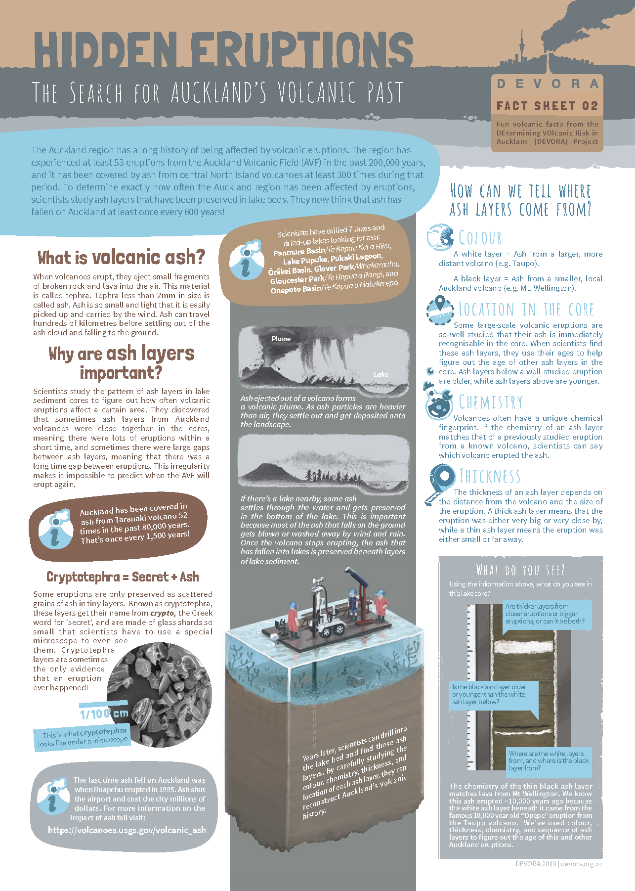
Image of the DEVORA Programme’s Fact Sheet 02, “Hidden Eruptions—The Search for Auckland’s Volcanic Past,” provides an overview of how scientists use tephra layers found in drill cores to piece together eruption histories. Produced in collaboration with illustrator Gavin Mouldey. The full suite of fact sheets is available at https://www.devora.org.nz/communications-and-education/facts-of-the-volcano-matter/.
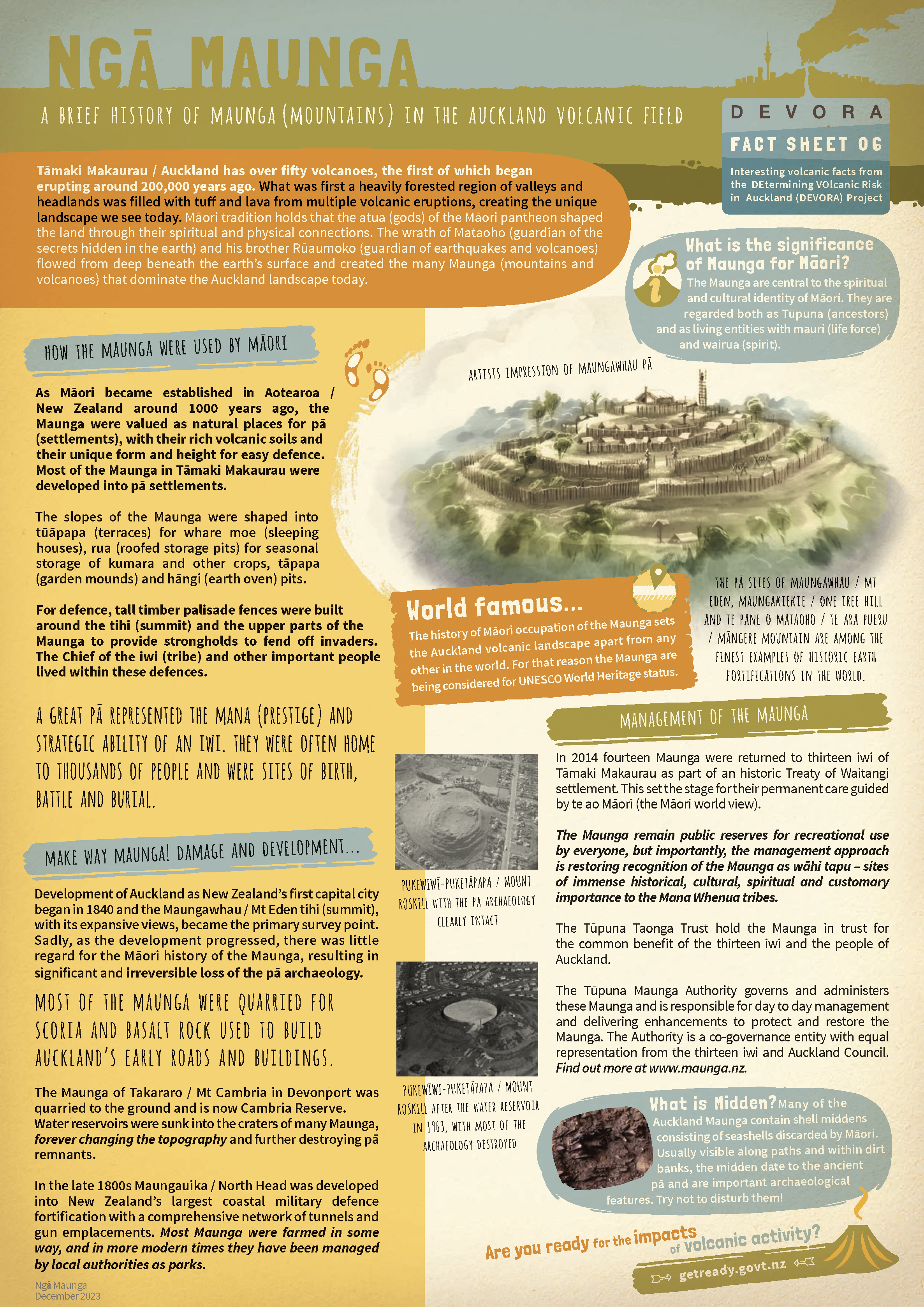
Image of the DEVORA Programme’s Fact Sheet 06, “Ngā Maunga—A Brief History of Maunga (Mountains) in the Auckland Volcanic Field,” provides a brief history of human interaction with the scoria cones (maunga) in Tāmaki Makaurau Auckland. This fact sheet was developed in collaboration with the Tūpuna Maunga Authority and illustrator Gavin Mouldey. The full suite of fact sheets is available at https://www.devora.org.nz/communications-and-education/facts-of-the-volcano-matter/.
As part of the program’s education, outreach, and training mission, DEVORA helped develop a role-play exercise in which a volcanic eruption in Tāmaki Makaurau Auckland unfolds and the participants, who take on roles as emergency managers and scientists, are tasked with responding to the evolving crisis (Dohaney and others, 2015; Fitzgerald and others, 2016). This role-playing exercise is run annually as part of a geohazards graduate course at UoA and sometimes at the University of Canterbury. The simulation is a full-day exercise in which 30–40 students meet in the Emergency Control Centre at AEM (when it is not being stood up for an actual emergency or a major weather event; in such cases, the venue shifts to the University of Auckland campus). The role-playing emergency management and scientist groups work together to address the events of the unrest and impending eruption and protect the people of Tāmaki Makaurau Auckland. Similar exercises have been run with volcano scientists from ESNZ, emergency managers from AEM, and the program’s partners at NHC Toka Tū Ake. These exercises expose participants to a realistic experience and emphasize the value of established relationships between scientists, emergency managers, and critical infrastructure providers when faced with the immediate deadlines and intense pressures of an eruption crisis. It is excellent exposure for professionals and students interested in a related career. Indeed, over the years, several students who have participated in the simulation have gone on to careers in emergency management, volcano monitoring, and hazard and risk management, and the feedback has been that the exercise was a valuable introduction to the real-world environment of crisis management.
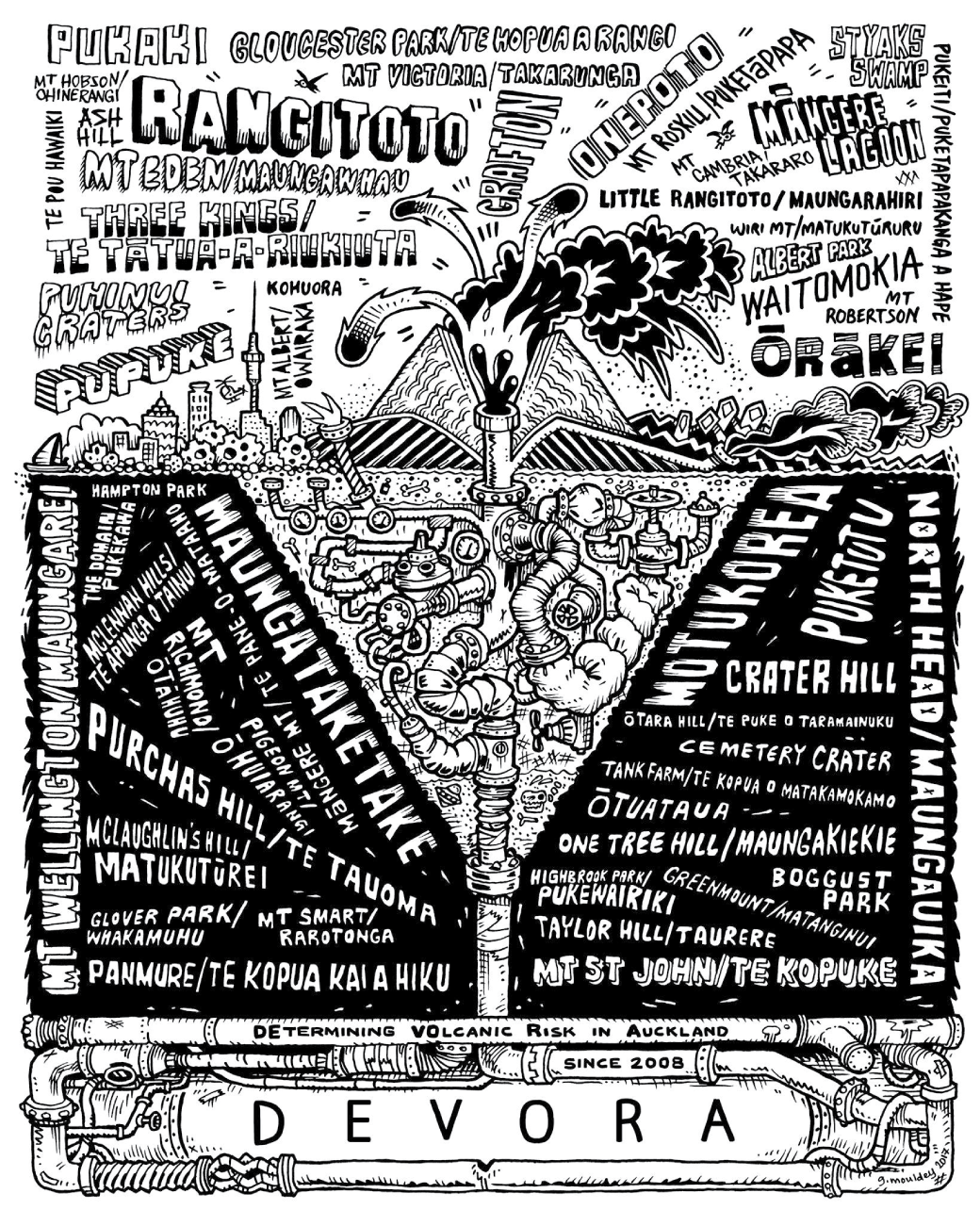
Illustration showing ten years of DEVORA as captured by illustrator Gavin Mouldey in 2018. The design includes the names of all 53 Auckland Volcanic Field volcanoes (font size correlates to frequency of mentions in DEVORA Quarterly Reports), a complex magma plumbing system, a maar-diatreme, a tuff cone, a steep-sided scoria cone, and an ash cloud.
Engagement with Stakeholders
Stakeholder engagement is critical to the mission of the DEVORA Programme. In other words, the program’s science includes topics of societal relevance toward preparing for and responding to volcanic activity in Tāmaki Makaurau Auckland. To this end, DEVORA is involved with multiple strategic partnerships to maximize the practical application of research that emerges from DEVORA. The research findings are shared with stakeholders through Steering Committee meetings, participatory workshops, bespoke presentations, and the annual forum. The scientific knowledge of DEVORA informs the action plans of AEM and various critical infrastructure groups, thus contributing to the ability of Tāmaki Makaurau Auckland to prepare for and respond to a volcanic eruption. Below, we provide some examples of engagement with key stakeholder agencies.
NHC Toka Tū Ake and Auckland Council
Our primary partners are NHC Toka Tū Ake and Auckland Council. NHC Toka Tū Ake is an Aotearoa New Zealand Crown entity that invests in natural disaster research and education and provides natural hazards insurance cover to homeowners. Major examples of DEVORA engagement with NHC Toka Tū Ake include collaborating on the permanent NHC Toka Tū Ake-funded volcanoes exhibition at Auckland Museum5 and on joint media releases (for example, the January 2024 media release about lava cave research [https://www.naturalhazards.govt.nz/news/research-tackles-history-and-mystery-around-auckland-lava-caves/]). Within Auckland Council, DEVORA has worked with AEM, the Research and Evaluation Unit (RIMU; now called Environmental Evaluation and Monitoring [EEM]), the Engineering, Assets and Technical Advisory (EATA) team (who coordinate natural hazards research), the Environmental Services team (that hosts Natural Features Specialists dealing with geoheritage matters), and the TMA. The EATA team, AEM, and the TMA have representation on the DEVORA Steering Committee, and DEVORA actively engages with each regarding the best ways to tailor DEVORA research for AEM and other planning functions. An example of engagement with AC was a workshop led by DEVORA in 2018 that involved 20 AC staff members and was aimed at familiarizing them with volcanic hazard and risk in the Auckland Volcanic Field. DEVORA has also supported AEM in their outreach efforts, teaming up on question-and-answer sessions on social media, making the most of public interest in high-profile eruptions elsewhere to share information about the Auckland Volcanic Field, such as after the 2018 Kīlauea eruption.6 DEVORA also provides subject matter expertise to AEM in the development of volcanic response plans. In 2022, DEVORA began collaborating with the AC Natural Features team on building a database of lava caves in Tāmaki Makaurau Auckland. Occasionally, DEVORA funds emergency management partners to attend international conferences to enable two-way sharing of insights internationally.
Lifeline (Critical Infrastructure) Organizations
It has long been recognized that the level of resilience in Tāmaki Makaurau Auckland in a volcanic event will strongly depend on the functionality of critical infrastructure, particularly utilities and transportation (for example, Daly and Johnston, 2015). In 2004, a consortium of volcanology and natural hazard researchers and practitioners established the Volcanic Impacts Study Group (VISG) as a sub-committee of the Auckland Engineering Lifelines Group (AELG; now just ALG), with the following aims (Wilson and others, 2014):
-
• To collate and advocate knowledge about the impacts of volcanic hazards (for instance, ash) on, and mitigation measures for, lifeline infrastructure;
-
• To facilitate and support research on the impacts of volcanic hazards on lifelines and people and the development of appropriate mitigation measures;
-
• To advise on the applicability for lifelines of any research being undertaken;
-
• To facilitate reconnaissance investigations and advocate for lifeline representation on reconnaissance investigations to active volcanic areas where this would add to our knowledge about volcanic impacts on infrastructure;
-
• To provide a national focal point for volcanic impacts work on lifelines.
Since its inception, DEVORA researchers have actively contributed to the objectives of the VISG, supporting ash impacts research and related activities. Volcanic impact data derived from the DEVORA Programme have helped inform a series of posters for critical infrastructure providers that describe ash fall impacts on infrastructure and possible mitigation measures (for more information, refer to http://www.aelg.org.nz/document-library/volcanic-ash-impacts/). The VISG developed these posters collaboratively with critical infrastructure managers, relevant government agencies, and volcanic impact researchers. This process has enhanced partnerships and networks between all parties involved (Wilson and others, 2014). The VISG periodically organizes workshops and forums that bring together researchers and critical infrastructure providers, and DEVORA researchers always support and participate in these activities. Where relevant, DEVORA also co-creates and co-authors research with these agencies. An example is the study by Deligne and others (2017a), which investigated the consequences of urban volcanism in Tāmaki Makaurau Auckland on infrastructure and is co-authored by staff from electricity service providers. Over time, DEVORA has also developed relationships with emergency responders and insurance companies. DEVORA researchers also regularly contribute to the annual Volcano Short Course for emergency managers and lifeline organizations run by ESNZ (for more information, refer to https://www.gns.cri.nz/news/volcano-short-course-2022/).
Engagement and Partnerships with Māori
Human occupation of Tāmaki Makaurau Auckland goes back roughly 1,000 years, when the arrival of ocean-going waka (canoes) from the Pacific brought people who settled along its shores (Tūpuna Maunga Authority, undated). The land was highly contested among different groups of the new arrivals, with prominent volcanic cones presenting the ideal locations for developing defendable pā (fortified village settlements) and the surrounding expansive areas of fertile volcanic soils suitable for agriculture, especially for the highly sacred practice of growing kūmara (sweet potato). According to the Tūpuna Maunga Authority (undated), these fertile soils combined with a highly strategic maritime location “made Tāmaki Makaurau an unparalleled center of Māori social organization and the most active hub of complex inter-tribal relationships and connections, transit, and trade in Māori society.” Consequently, Tāmaki Makaurau Auckland was, and still is today, one of the most heavily populated areas of Aotearoa New Zealand; its attractive and diverse natural environment and strategic location appealing to more recent arrivals as well. Māori are the only humans to have witnessed an eruption in the Auckland Volcanic Field: the birth of Rangitoto, the largest and youngest volcano in the Auckland Volcanic Field. Rangitoto formed during two distinct periods of eruption: ~550 and 500 calibrated years before present (that is, 1400 and 1450 C.E.; Needham and others, 2011), and its activity was witnessed by Māori on neighboring Motutapu Island (Nichol, 1992).
Oral histories and archaeological evidence show that by the 1500s, at least nine of the volcanic cones were occupied (Hayward, 2019). The volcanic cones of Tāmaki Makaurau Auckland are considered Tūpuna Maunga (ancestral mountains), and are part of the historical, spiritual, ancestral, and cultural identity of the iwi and hapū (Māori tribes) of Tāmaki Makaurau Auckland. The Tūpuna Maunga are revered as the creations of Mataaho (the guardian of the Earth’s secrets) and Rūaumoko (the god of earthquakes and volcanoes), and were important locations for settlement, agriculture, battles, marriages, birth, and burial (Tūpuna Maunga Authority, undated). The Ngā Mana Whenua o Tāmaki Makaurau Collective Redress Act of 2014 placed 14 of these Tūpuna Maunga under the care of the Tūpuna Maunga Authority.
Around the same time that the initial DEVORA proposal was being finalized, the transformational Vision Mātauranga7 policy framework was under development within the then Ministry of Research Science and Technology (now known as the Ministry of Business, Innovation and Employment [MBIE]) in Aotearoa New Zealand. The mission of this policy was to “unlock the innovation potential of Māori knowledge, resources, and people to assist New Zealanders to create a better future” (Ministry of Research, Science and Technology, 2007, p. 3). The policy was created to provide strategic direction for research of relevance to Māori and, over the subsequent years, has been increasingly integrated into government funding bodies in Aotearoa New Zealand. This MBIE policy clearly communicated that research conducted in Aotearoa New Zealand should recognize and support Māori knowledge and be designed with a clear engagement pathway. Although DEVORA was developed before the policy was rolled out, the DEVORA leaders have taken steps to modify and improve the research program to be more responsive to Māori and to meet the aspirations of this policy. Most recently, DEVORA added the Manutaki role to the project management team. Since 2015, representation from the Tūpuna Maunga Authority has been present on the DEVORA Steering Committee, and in 2021 a Māori Engagement Strategy was developed (document 8 of Lindsay and others [2026]). A major goal of DEVORA is to engage as much as possible with Māori on research carried out on their ancestral lands. A partnership is being developed with the Te Pane o Mataoho Māngere Mountain Education Centre, which includes co-leading field trips with center guides to the mountain where volcanology, cultural history, and Indigenous knowledge is shared (for example, Smid and others, 2023). In a flagship project, commencing in 2023, DEVORA recruited a Māori doctoral student to explore the interface between modern science and Mātauranga Māori (Māori knowledge, including the Māori worldview, creativity, and cultural practices) in the Auckland Volcanic Field (Tapuke, 2023). In recognition of past colonizing practice of renaming landmarks, and in support of revitalizing te reo Māori, DEVORA is advocating for the use of the Māori names for the volcanoes and updating relevant maps and databases accordingly (for instance, the list of Auckland Volcanic Field names hosted by the Smithsonian Institution; Global Volcanism Program, 2023). Funding has also been set aside for researchers and members of the DEVORA management team to expand their knowledge of te reo Māori and Māori protocols and practices to build cultural capability and awareness within the program.
“Mātauranga” is a te reo Māori word meaning knowledge, wisdom, and understanding.
Science Outcomes and New Knowledge Generated
This section overviews DEVORA’s key scientific outcomes; for a more comprehensive review, refer to Hopkins and others (2021).
Great strides have been made in understanding mantle sources and compositions (McGee and others, 2013, 2015; Hopkins and others, 2016); magma ascent through the crust (Le Corvec and others, 2013a, 2013b); precursory signals and warning times (Ashenden and others, 2011); and the likely magnitude, style, location, and effects of future dangerous and costly hazards such as pyroclastic surges, lava flows, and ash (Hayes and others, 2017; Kereszturi and others, 2017). The precise locations and eruption styles of the 53 known volcanic centers are now known (for example, Agustín-Flores and others, 2015), and a focused radiometric and tephrochronological dating program has enabled us to place 48 of the 53 centers in relative order of eruption (Zawalna-Geer and others, 2016; Hopkins and others, 2017, 2021; Leonard and others, 2017). We know that the relative likelihood of explosive versus extrusive eruption styles changes across the city depending on environmental conditions (seawater, hard rock, partially saturated ground, and so forth) (Kereszturi and others, 2014; Ang and others, 2020), and knowledge of likely hazard footprints in the event of an eruption has led to recommendations for evacuation planning (for example, Lindsay and others, 2010; Sandri and others, 2012).
DEVORA has created eight representative unrest-to-eruption scenarios to aid planning for an Auckland Volcanic Field eruption and to complement quantitative probabilistic and risk-based approaches (Hayes and others, 2018, 2020). The scenarios cover a range of eruption styles and sizes and are tailored to specific environmental conditions. Each scenario draws on the latest domestic and international research to portray credible hazards and hazard intensities given various substrates and magma volumes and their corresponding eruption styles and sizes. They were co-produced in a transdisciplinary project involving scientists, emergency managers, and representatives from critical infrastructure providers to create a product representing a common language between scientists and stakeholders (Hayes and others, 2020). In a further step, a novel methodology was developed to bridge scenario-based and probabilistic volcanic hazard assessments by deriving a pseudo-probabilistic hazard estimate from the suite of scenarios, in which the relative likelihoods of each scenario at every location in the field were identified (Ang and others, 2020). These scenarios have allowed DEVORA to work with our lifeline partners to model the potential effects on infrastructure (for example, Deligne and others, 2015, 2017a; Blake and others, 2017), to estimate the economic consequences of an eruption in Tāmaki Makaurau Auckland (for example, Cardwell and others, 2020, 2021), to explore the potential use of cost-benefit analysis in evacuation decision making (for example, Wild and others, 2022, 2023), and to model gas hazards (Brody-Heine and others, 2024).
In the early years of DEVORA, the program funded and managed the development of the DEVORA borehole database, which collated geotechnical data from sites across Tāmaki Makaurau Auckland. These data were used in projects to evaluate the distribution of tephra across the region (for example, Slabbert, 2017), ground truth geophysical studies (for example, Gasston and others, 2021), and identify hidden faults in Tāmaki Makaurau Auckland (Kenny and others, 2012; 2025). After the 2010–11 Christchurch earthquakes, the DEVORA borehole database was merged with the Canterbury borehole database to form the New Zealand Geotechnical Database (NZGD; https://nzgd.org.nz/), which has since grown to include data from across the country. This is a great achievement, given that most of the datasets were proprietary, confidential, and siloed at individual consultancies prior to the development of the NZGD. The NZGD now has more than 7,000 users and holds geotechnical data with an estimated value of more than $NZ 500 million.8 As many of DEVORA’s scientific endeavors depend on understanding the make-up and structural elements of the crust, this dataset is essential. Moreover, it is an example of how DEVORA research can provide value far beyond the volcanic realm and motivates our stakeholders to continue to support the program.
DEVORA researchers work very closely with RiskScape, an open-source spatial data processing application used for multi-hazard risk analysis in Aotearoa New Zealand (Paulik and others, 2023. Over the last 15 years, DEVORA has worked with critical infrastructure providers (for instance, electricity, airport, transport, telecommunications, banks) to incorporate network structures and assets into the RiskScape tool and test its efficacy (for example, Deligne and others 2017b). Researchers have also worked to examine possible volcanic impacts in laboratory settings and use their findings to generate mitigation solutions for critical infrastructure organizations. Examples of this work are the impacts of tephra on roads (Blake and others, 2017) and electricity networks (Wardman and others, 2012); of ballistics and tephra on buildings (Fitzgerald and others, 2017; Williams and others, 2019; Allen, 2021); and of lava on pavements, roading, and buried infrastructure (Tsang and others, 2019, 2020). Volcanic ash impact data derived from the DEVORA Research Programme have been summarized in a series of posters intended to improve the resilience of critical infrastructure organizations to volcanic ash fall hazards (Wilson and others, 2014).
RiskScape’s asset database for Tāmaki Makaurau Auckland and the vulnerability functions for hazards expected in a future Auckland Volcanic Field eruption are major DEVORA achievements that enable stakeholders to better assess and plan for potential risks of a variety of natural hazards, not just volcanic eruptions. Through the RiskScape tool, it is now possible to compare impacts from different hazards, such as volcanic ash fall, tsunami, and surface flooding. It is also possible to compare the benefits of different mitigation options for a specific hazard. The DEVORA Programme has also begun to transition from impact assessments to probabilistic loss calculation. The first step toward developing a probabilistic loss assessment methodology has been to estimate losses from every DEVORA eruption scenario (Williams and others, 2024). DEVORA researchers have also contributed to volcano disaster waste management and planning in Tāmaki Makaurau Auckland, identifying the costs, challenges, and opportunities for clean-up, disposal, and stabilization of volcanic ash (Hayes and others, 2017), and DEVORA recently supported a doctoral study in disaster law, focused on post-disaster recovery governance in the case of an Auckland Volcanic Field eruption (Faulkner, 2024).
We estimate that more than 200 peer-reviewed publications have arisen through support from the DEVORA Programme (refer to https://www.devora.org.nz/resources/devora-publications/ for a full list of DEVORA publications). These contribute to the understanding of the Auckland Volcanic Field and collective global understanding of distributed volcanism and the associated hazards and risks. In the context of Tāmaki Makaurau Auckland, the body of knowledge generated through DEVORA supports emergency management decision-making at all stages, from assessing mitigation options (for instance, choosing the most resilient options for major new assets and infrastructure) to increasing certainty for decision-making around the call for mass evacuation.
Contribution to Capacity Building
Since its inception, DEVORA has directly or indirectly supported more than 100 researchers, students, practitioners, and research assistants across more than 10 institutions, including government agencies and overseas universities. Postgraduate student research projects are considered flagship products within DEVORA and the early-career research assistants as the invaluable glue that holds the entire program together. DEVORA has funded or co-funded more than 50 students at various universities at the doctoral, masters, and honors levels since its creation. Current and past doctoral students total 30, 17 of which are female (60 percent). DEVORA’s first Māori doctoral student was recruited in 2023.
Many of these students have worked as DEVORA interns or research assistants. We estimate that DEVORA has provided research assistantships for more than 30 students over the duration of the program. Research assistants work on projects ranging from general project management support and outreach to specific research projects, such as exploring historical seismicity in Tāmaki Makaurau Auckland, to more data management projects, such as developing and maintaining the DEVORA borehole database and applying for permits for fieldwork or drilling.
Given the modest annual funding, DEVORA has yet to be able to regularly support advertised postdoctoral fellowships, with one important exception. Toward the end of Phase 1 of DEVORA, it became increasingly clear that the program did not have the capability or capacity to tackle risk assessment comprehensively. This was partly due to the challenge of collating hazard, vulnerability, and in particular, exposure information, which was a time-consuming task that fell outside of all existing project capacities. In 2012, the strategic decision was made to focus a large proportion of DEVORA funding on a two-year postdoctoral fellow to be based at GNS Science (now ESNZ) with the task of accelerating the risk work within DEVORA. Dr. Natalia Deligne was hired into this role. During her several years with DEVORA and at GNS Science, she successfully facilitated the selection of hazard models and the connection between relevant datasets, leading to the development of various impact assessments (for example, Blake and others, 2017; Deligne and others, 2017b) and paving the way for deterministic and probabilistic risk assessments.
DEVORA’s Broader Influence in the National and International Research Ecosystem
Throughout the research program, efforts by DEVORA to build relationships and maintain reciprocal, open lines of communication between scientists, stakeholders, and the public have created a strong, cohesive, and engaged community for the program’s partners to draw upon to prepare for the next Auckland Volcanic Field eruption. This successful model has been emulated by other hazard research programs across Aotearoa New Zealand, such as the Ministry of Business, Innovation, and Employment (MBIE)-funded Eruption or Catastrophe: Learning to Implement Preparedness for future Supervolcano Eruptions (ECLIPSE) program, which aims to understand hazard from the country’s largest volcanoes. Refer to https://sites.google.com/view/eclipse-supervolcanoes/home for more information. The Communications Plan and Media Guide has also been shared (document 7 of Lindsay and others [2026]) and ideas are regularly exchanged regarding outreach with various other programs. The DEVORA Programme’s influence also extends beyond Aotearoa New Zealand, with the research team being invited to develop a similar project, modeled on DEVORA, for Al Madinah Al Munawwarah in the Kingdom of Saudi Arabia. The subsequent VOlcanic RIsk in Saudi Arabia (VORISA) project ran for three years (2011–13). It was a collaboration between King Abdulaziz University, the Kingdom of Saudi Arabia, and the University of Auckland (Lindsay and Moufti, 2014a), with the research culminating in a detailed volcanic hazard assessment for the volcanic lava field of Ḩarrat Rahat (Lindsay and Moufti, 2014b). DEVORA has also become a touchpoint for researchers elsewhere in the world working on areas of distributed volcanism and its potential to affect society, such as a consortium of German researchers working on the Eifel region of Germany and the researchers within the U.S. Geological Survey (USGS) who are working on volcano hazards and threat assessments of distributed volcanic fields in the United States and its territories.
Lessons Learned
The DEVORA Programme has accumulated valuable insights and lessons learned, which are discussed in this section.
Long-Term Programs Like DEVORA Serve as a Nexus for Research Activity
Before the DEVORA Programme was set up, research on the Auckland Volcanic Field and volcanic impacts in Tāmaki Makaurau Auckland was uncoordinated and undertaken on an ad hoc basis. In the early stages of the program, DEVORA sought to summarize all past knowledge in a series of state-of-play reports, which included recommendations that focused our efforts and informed initial work plans. Since then, engagement between researchers and stakeholders has guided DEVORA’s choice of funded projects. However, funding levels and program scope mean that not all research on volcanism and its impacts in Tāmaki Makaurau Auckland can be funded through DEVORA; some research is funded through other sources, such as the contestable Marsden Fund administered by the Royal Society Te Apārangi. Since its inception, DEVORA has strived to maintain an open-door policy where possible; in other words, it attempts to welcome all researchers working on relevant projects into the team and to share knowledge and resources, regardless of whether DEVORA funded them directly. There is also an attempt to cover all relevant research and related activity in the annual research forum and quarterly reports (there is a dedicated section in DEVORA reports summarizing progress on affiliated projects that provides a broad view of current Auckland Volcanic Field research for stakeholders). In this way, the DEVORA management team maintains awareness of research that might be relevant for stakeholders and is always open to requests for co-funding or in-kind support, such as connecting new researchers and research projects with stakeholders.
Although it is beneficial for a consortium to provide this nexus, there may be some unexpected consequences. For example, such a long-lived research program may inadvertently become the de facto touch point for operational matters. In DEVORA’s case, because of strong stakeholder relationships, DEVORA has become the primary contact point for AEM on operational matters such as Auckland Volcanic Field response planning. Concurrently, the body responsible for such engagement, the Auckland Volcano Science Advisory Group (AVSAG), has become inactive, partly because the same people are involved in both this group and DEVORA. Although much of the function of AVSAG has been taken up by the New Zealand Volcano Science Advisory Panel, scientific input is still needed for emergency management planning in Tāmaki Makaurau Auckland. Thorough discussions with relevant emergency management personnel within and beyond the DEVORA Steering Committee have explored whether this should occur on a more structured, regular basis rather than on an ad hoc, on-demand basis by the DEVORA team. Researchers and emergency managers are currently working together to redefine the roles of AVSAG, NZVSAP and DEVORA in the emergency management planning context.
A Stable Annual Planning Cycle Facilitates a Broad Scope
DEVORA benefits from long-term, stable, small-dollar annual funding, which allows a considerable amount to be achieved over time. This contrasts with the model in which larger dollar amounts of research funding are available over a shorter time frame. There are benefits to both approaches. However, doctoral projects are potentially better supported in the slow-burn DEVORA-like model. This model also enables us to address questions and findings as they arise or follow through on remaining questions after studies are completed. For example, the DEVORA funding model has allowed the program to explore the implications of new research by Valentine and others (2022) regarding longer than previously thought run-out distances for base surges in monogenetic fields. Prompted by this study, DEVORA’s stakeholder partners agreed that better knowledge of base surge run-out distances in the Auckland Volcanic Field was a priority for their planning needs. This research project was thus added into the next annual work plan in 2023–24 (document 3 of Lindsay and others [2026]), showing the program’s ability to rapidly respond to new cutting-edge science and provide value to stakeholders.
Once the foundation for the program was laid during Phase 1, the sustained annual funding thereafter allowed DEVORA to grow the program and research many topics in fine detail. For example, the 2023–24 work plan (document 3 of Lindsay and others [2026]) supported four doctoral student projects on volcanic plumbing systems and crustal structure; mantle sources, magma ascent, and gas hazards; the interface between Indigenous knowledge and volcanology; and base surge geology, modelling, and impacts in the Auckland Volcanic Field in light of new research findings from an analogue volcanic field at Ubehebe Crater, California, United States. Other research (by sub-doctoral graduate students) supported in the same year ranges from characterizing lava tube caves to documenting historical seismicity in the Tāmaki Makaurau Auckland region.
The slow-burn funding model has also enabled DEVORA to develop a range of partnerships and strategies that support the communication, effective translation, and uptake of its research. For example, DEVORA has developed partnerships with the House of Science,9 which supplies bilingual science resource kits for Aotearoa New Zealand school children; TephraNZ,10 a major and trace element geochemical reference dataset for prominent Aotearoa New Zealand tephra; the NZGD,11 a database developed for professional geotechnical and structural engineers to access geotechnical data shared by other engineers and their clients, and to share their own data in return; and Gavin Mouldey,12 an illustrator who collaborates with DEVORA on fact sheets and other outreach products. There was also time to conceptualize and create the Communications Plan and Media Guide, Outreach Strategy, and Māori Engagement Strategy (documents 7, 5, and 8 of Lindsay and others [2026], respectively). Arguably, such a wide range of research projects, partnerships, and resources would not have been possible in a short-term funding scenario. The sustained funding has enabled stable partner relationships and capacity building with student researchers, resulting in a solid knowledge base of volcanic hazards and risks in the Auckland Volcanic Field.
Stable long-term funding and an annual planning cycle facilitate regular, sustained, and meaningful stakeholder engagement. Because funding is reallocated yearly, there are regular opportunities for stakeholder input into the work program, as well as into the overarching goals and aspirational outcomes of the program, which have evolved with time. In contrast, multi-year but fixed-dollar research programs funded in advance may include intense stakeholder engagement at the onset to co-create a multi-year work plan. The disadvantage of that model is that there may be limited opportunities to respond to ongoing and shifting stakeholder priorities once funds are committed, and engagement may decrease. Sustained relationships benefit DEVORA because they maintain consistency in the face of high staff turnover within stakeholder agencies (for instance, local government). The longevity of the DEVORA Programme, annual research forums, and the twice-yearly steering committee meetings with key stakeholders mean that DEVORA can take the time to build relationships with new staff. In this way, DEVORA is a reliable vehicle for stakeholders to become informed about volcanic research on the Auckland Volcanic Field.
Regular Engagement Facilitates a Deeper Understanding of Uncertainties Associated with Volcanic Hazards and Risks
One of the most challenging concepts for non-volcanologists to grasp about volcanic fields is the distributed nature of eruptions. The individual volcanoes in the Auckland Volcanic Field are considered extinct, but the field itself is still active. New eruptions can thus occur anywhere in the field, and there may be little warning; magma may rise from the mantle with no seismicity generated until it reaches the more brittle crust. The more the research results are discussed with non-scientist stakeholders, the more they understand these concepts and the inherent uncertainties they imply. Furthermore, approaches can be co-created to try and reduce these uncertainties (for example, through exploring novel monitoring techniques that might increase warning times) or develop strategies and tools to better handle the uncertainties. One example of this is the co-development of the suite of unrest and eruption scenarios that explore a range of eruption locations, potential consequences, and evacuation implications. Conversely, regular engagement allows DEVORA to understand what stakeholders need and where volcanic hazards and risks sit within the overall hazard framework and priorities of AEM and Auckland Council.
The DEVORA Programme has also supported research on non-volcanic hazards and their impacts. Studies on the crustal structure and baseline seismicity of the region are essential to understanding earthquake hazards. Populating RiskScape with exposure information benefits all-hazard loss assessment and allows risk comparison between hazards. The research quantifying secondary fire hazards from eruptions is relevant to fire hazards in general. Engaging with stakeholders in this broader context means that individual hazards, both volcanic and non-volcanic, are not viewed in isolation, and a shared mental model of the HazardScape in Tāmaki Makaurau Auckland can be developed and the possibility of multiple contemporaneous or cascading hazards considered.
Additional Key Lessons
-
• The project manager and research assistantship roles within DEVORA are invaluable and ensure that the day-to-day activities of the project are carried out. The program has been successful because funds were put aside from the beginning for supporting roles.
-
• Stable co-leadership from within both the university and government sectors (represented by UoA and ESNZ, respectively) provides a consistent but flexible vision that helps ensure the program stays on task and is integrated with other hazard and risk research programs in Aotearoa New Zealand.
-
• Engagement with Māori would have been beneficial from the beginning and DEVORA is taking steps to rectify this. Research programs in areas with Indigenous communities could consider how to be responsive to and engage with them. To this end, DEVORA is funding and trialing a “Manutaki,” or knowledge broker, role.
-
• Providing opportunities for two-way knowledge transfer and relationship building between DEVORA stakeholders and the wider volcanological research community can lead to sharing of useful learnings associated with managing volcanic risk at volcanoes in urban settings. To encourage this, DEVORA has supported representatives from AEM to attend international conferences.
-
• Research stakeholders and partners do not like to be surprised by media attention related to research on hazard and risk. Because of this, the Communications Plan and Media Guide was developed in response to an instance where our partners were surprised and put on the spot by media.
-
• The DEVORA outreach group was created in response to the high demand for specialists to engage with the public. This was not budgeted for in the original workplan; over time the value of a dedicated outreach coordinator has been recognized and the budget adjusted accordingly.
-
• When high-profile eruptions are occurring, the public tends to have a greater interest in and capacity to learn about volcanoes. This can be leveraged during public outreach events to teach about the hazards and risks of the Auckland Volcanic Field; for instance, DEVORA collaborated with AEM on outreach activities following the 2018 Kīlauea and 2019 Whakaari White Island eruptions.
-
• Connecting with the international community of distributed volcanism researchers helps DEVORA to learn from analog volcanic systems (for example, there have been collaborations with teams at monogenetic volcanic fields on Jeju Island, Republic of Korea, and Ubehebe Craters, California, United States). Similarly, DEVORA presents at international conferences and seeks international peer review of its approaches.
-
• Partnering with an artist helps to convey concepts. There has been positive anecdotal feedback on DEVORA’s commemorative tea towel and Fact Sheet series. Working with an artist who is not a volcanology expert highlights potentially confusing concepts and helps improve DEVORA’s science communication.
-
• An annual forum provides a safe environment for students to present since it is often their first conference presentation. The forum is an opportunity for stakeholders to learn about and discuss the implications of the latest findings and for DEVORA researchers to understand stakeholder priorities better. It also provides time to gather and conceptualize ideas for future projects. Stakeholders who may not see each other often can reconnect and strengthen their relationships at these forums. There is also a regular slot where DEVORA leaders consciously ask, “Are we missing anything? Are there any gaps to be filled?” and participants explore new approaches and unconventional project ideas.
Summary
The Determining Volcanic Risk in Auckland (DEVORA) Research Programme exemplifies a transdisciplinary approach to volcanic risk research, aiming to provide a comprehensive understanding of the hazards and vulnerabilities associated with the Auckland Volcanic Field. DEVORA endeavors to foster resilience and to inform risk management strategies through effective ongoing stakeholder engagement, emerging involvement with Māori partners, and a commitment to public outreach. Its outputs, outcomes, and influence on other research programs demonstrate the far-reaching value of such interdisciplinary approaches in addressing complex volcanic risks in urban environments. The lessons learned from DEVORA can guide future research endeavors, provide a proof-of-concept research program model for potential stakeholders and researchers elsewhere, and contribute to the ongoing development of resilient communities in volcanic regions worldwide.
References Cited
Agustín-Flores, J., Németh, K., Cronin, S.J., Lindsay, J.M., and Kereszturi, G., 2015, Construction of the North Head (Maungauika) tuff cone—A product of Surtseyan volcanism, rare in the Auckland Volcanic Field, New Zealand: Bulletin of Volcanology, v. 77, no. 2, p. 11, https://doi.org/10.1007/s00445-014-0892-9.
Allen, N.E., 2021, Multi-volcanic hazard impact assessment for residential buildings in the Auckland Volcanic Field, New Zealand: Christchurch, University of Canterbury, Ph.D. dissertation, 194 p., https://doi.org/10.26021/12597.
Ang, P.S., Bebbington, M.S., Lindsay, J.M., and Jenkins, S.F., 2020, From eruption scenarios to probabilistic volcanic hazard analysis—An example of the Auckland Volcanic Field, New Zealand: Journal of Volcanology and Geothermal Research, v. 397, p. 106871, https://doi.org/10.1016/j.jvolgeores.2020.106871.
Ashenden, C.L., Lindsay, J.M., Sherburn, S., Smith, I.E.M., Miller, C.A., and Malin, P.E., 2011, Some challenges of monitoring a potentially active volcanic field in a large urban area—Auckland volcanic field, New Zealand: Natural Hazards, v. 59, no. 1, p. 507–528, https://doi.org/10.1007/s11069-011-9773-0.
Blake, D.M., Deligne, N.I., Wilson, T.M., Lindsay, J.M., and Woods, R., 2017, Investigating the consequences of urban volcanism using a scenario approach II—Insights into transportation network damage and functionality: Journal of Volcanology and Geothermal Research, v. 340, p. 92–116, https://doi.org/10.1016/j.jvolgeores.2017.04.010.
Brenna, M., Cronin, S.J., Smith, I.E.M., Tollan, P.M.E., Scott, J.M., Prior, D.J., Bambery, K., and Ukstins, I.A., 2018, Olivine xenocryst diffusion reveals rapid monogenetic basaltic magma ascent following complex storage at Pupuke Maar, Auckland Volcanic Field, New Zealand: Earth and Planetary Science Letters, v. 499, p. 13–22, https://doi.org/10.1016/j.epsl.2018.07.015.
Brody-Heine, S., Katurji, M., Stewart, C., Wilson, T., Smid, E.R., and Trancoso, R., 2024, Modeling SO2 dispersion from future eruptions in the Auckland Volcanic Field, New Zealand: Journal of Applied Volcanology, v. 13, no. 1, p. 2, https://doi.org/10.1186/s13617-024-00141-0.
Cardwell, R.J., McDonald, G.W., and Wotherspoon, L.M., 2020, Simulation of post-volcanic eruption time variant land use and economic impacts in the Auckland region of New Zealand: Bulletin of Volcanology, v. 82, no. 9, p. 64, https://doi.org/10.1007/s00445-020-01400-9.
Cardwell, R., McDonald, G., Wotherspoon, L., and Lindsay, J., 2021, Simulation of post volcanic eruption land use and economic recovery pathways over a period of 20 years in the Auckland region of New Zealand: Journal of Volcanology and Geothermal Research, v. 415, p. 107253, https://doi.org/10.1016/j.jvolgeores.2021.107253.
Daly, M., and Johnston, D., 2015, The genesis of volcanic risk assessment for the Auckland engineering lifelines project: 1996–2000: Journal of Applied Volcanology, v. 4, no. 1, p. 7, https://doi.org/10.1186/s13617-015-0027-9.
Deligne, N.I., Blake, D.M., Davies, A.J., Grace, E.S., Hayes, J., Potter, S.H., Stewart, C., Wilson, G., and Wilson, T.M., 2015, Economics of resilient infrastructure Auckland Volcanic Field scenario: GNS Science ERI Research Report 2015/03, 151 p., accessed March 15, 2024, https://shop.gns.cri.nz/eri_2015-003-pdf/.
Deligne, N.I., Fitzgerald, R.H., Blake, D.M., Davies, A.J., Hayes, J.L., Stewart, C., Wilson, G., Wilson, T.M., Castelino, R., Kennedy, B.M., Muspratt, S., and Woods, R., 2017a, Investigating the consequences of urban volcanism using a scenario approach I—Development and application of a hypothetical eruption in the Auckland Volcanic Field, New Zealand: Journal of Volcanology and Geothermal Research, v. 336, p. 192–208, https://doi.org/10.1016/j.jvolgeores.2017.02.023.
Deligne, N.I., Horspool, N., Canessa, S., Matcham, I., Williams, G.T., Wilson, G., and Wilson, T.M., 2017b, Evaluating the impacts of volcanic eruptions using RiskScape: Journal of Applied Volcanology, v. 6, no. 1, p. 18, https://doi.org/10.1186/s13617-017-0069-2.
Deligne, N.I., Leonard, G.S., Jolly, A.D., Christenson, B.W., Hamling, I.J., Hreinsdottir, S., Mazot, A., Miller, C.A., Roberts, R., and van Wijk, K., 2019, DEVORA novel monitoring techniques workshop, 25 October 2018: Lower Hutt, New Zealand, GNS Science report 2019/21, 50 p., accessed March 15, 2024, at https://doi.org/10.21420/GMZJ-J453.
Dohaney, J., Brogt, E., Kennedy, B., Wilson, T.M., and Lindsay, J.M., 2015, Training in crisis communication and volcanic eruption forecasting—Design and evaluation of an authentic role-play simulation: Journal of Applied Volcanology, v. 4, no. 1, p. 12, https://doi.org/10.1186/s13617-015-0030-1.
Faulkner, H., 2024, Ready or not? Legal preparedness for an Auckland Volcanic Field eruption: Christchurch, New Zealand, University of Canterbury, Ph.D. dissertation, 293 p., https://doi.org/10.26021/15669.
Fitzgerald, R.H., Kennedy, B.M., Wilson, T.M., Leonard, G.S., Tsunematsu, K., and Keys, H., 2017, The communication and risk management of volcanic ballistic hazards, in Fearnley, C.J., Bird, D.K., Haynes, K., McGuire, W.J., and Jolly, G., eds., Observing the Volcano World—Volcano crisis communication, in Nemeth, K., ed., Advances in Volcanology: Springer Cham, p. 121–147, https://doi.org/10.1007/11157_2016_35.
Gasston, C., Lindsay, J.M., Eccles, J.D., Brook, M., Hill, M., and Kenny, J., 2021, A geophysical and geomorphological investigation of large‐offset normal faulting in Beachlands, Auckland: New Zealand Journal of Geology and Geophysics, v. 64, no. 1, p. 37–48, https://doi.org/10.1080/00288306.2020.1734032.
Global Volcanism Program, 2023, Auckland Volcanic Field (241020) in Venzke, E., ed., Volcanoes of the World (v. 5.1.5): Washington, D.C., Smithsonian Institution database, accessed December 15, 2023, at https://volcano.si.edu/volcano.cfm?vn=241020.
Hayes, J., Wilson, T.M., Deligne, N.I., Cole, J., and Hughes, M., 2017, A model to assess tephra clean-up requirements in urban environments: Journal of Applied Volcanology, v. 6, no. 1, p. 1, https://doi.org/10.1186/s13617-016-0052-3.
Hayes, J.L., Tsang, S.W., Fitzgerald, R.H., Blake, D.M., Deligne, N.I., Doherty, A., Hopkins, J.L., Hurst, A.W., Le Corvec, N., Leonard, G.S., Lindsay, J.M., Miller, C.A., Németh, K., Smid, E., White, J.D.L., and Wilson, T.M., 2018, The DEVORA scenarios—Multi-hazard eruption scenarios for the Auckland Volcanic Field: Lower Hutt, New Zealand, GNS Science report 2018/29, 138 p., https://doi.org/10.21420/G20652.
Hayes, J.L., Wilson, T.M., Deligne, N.I., Lindsay, J.M., Leonard, G.S., Tsang, S.W.R., and Fitzgerald, R.H., 2020, Developing a suite of multi-hazard volcanic eruption scenarios using an interdisciplinary approach: Journal of Volcanology and Geothermal Research, v. 392, p. 106763, https://doi.org/10.1016/j.jvolgeores.2019.106763.
Hopkins, J.L., Timm, C., Millet, M.-A., Poirier, A., Wilson, C.J.N., and Leonard, G.S., 2016, Os isotopic constraints on crustal contamination in Auckland Volcanic Field basalts, New Zealand: Chemical Geology, v. 439, p. 83–97, https://doi.org/10.1016/j.chemgeo.2016.06.019.
Hopkins, J.L., Wilson, C.J.N., Millet, M.-A., Leonard, G.S., Timm, C., McGee, L.E., Smith, I.E.M., and Smith, E.G.C., 2017, Multi-criteria correlation of tephra deposits to source centres applied in the Auckland Volcanic Field, New Zealand: Bulletin of Volcanology, v. 79, no. 7, p. 55, https://doi.org/10.1007/s00445-017-1131-y.
Hopkins, J.L., Smid, E.R., Eccles, J.D., Hayes, J.L., Hayward, B.W., McGee, L.E., van Wijk, K., Wilson, T.M., Cronin, S.J., Leonard, G.S., Lindsay, J.M., Németh, K., and Smith, I.E.M., 2021, Auckland Volcanic Field magmatism, volcanism, and hazard—A review: New Zealand Journal of Geology and Geophysics, v. 64, no. 2-3, p. 213–234, https://doi.org/10.1080/00288306.2020.1736102.
Horrocks, J., 2008, Exercise Ruamoko ‘08—Final exercise report: Ministry of Civil Defence and Emergency Management, Auckland, New Zealand, 80 p., accessed March 15, 2024, at https://www.dpmc.govt.nz/sites/default/files/2019-11/dpmc-roiar-oia-2019-20-0222-exercise-ruaumoko-final-report.pdf.
Horspool, N.A., Savage, M.K., and Bannister, S., 2006, Implications for intraplate volcanism and back-arc deformation in northwestern New Zealand, from joint inversion of receiver functions and surface waves: Geophysical Journal International, v. 166, no. 3, p. 1466–1483, https://doi.org/10.1111/j.1365-246X.2006.03016.x.
Kenny, J.A., Lindsay, J.M., and Howe, T.M., 2012, Post‐Miocene faults in Auckland—Insights from borehole and topographic analysis: New Zealand Journal of Geology and Geophysics, v. 55, no. 4, p. 323–343, https://doi.org/10.1080/00288306.2012.706618.
Kenny, J.A., Lindsay, J.M., Muirhead, J.D., Eccles, J.D., Luthfian, A., Ingold, J., van Wijk, K., Miller, C., Howe, T.M., and Kirk, P., 2025, Identifying obscured faults in urban areas—Insights from Tāmaki Makaurau Auckland, Aotearoa New Zealand: New Zealand Journal of Geology and Geophysics, v. 68, no. 4, p. 897–917, https://doi.org/10.1080/00288306.2025.2519722.
Kereszturi, G., Németh, K., Cronin, S.J., Procter, J., and Agustín-Flores, J., 2014, Influences on the variability of eruption sequences and style transitions in the Auckland Volcanic Field, New Zealand: Journal of Volcanology and Geothermal Research, v. 286, p. 101–115, https://doi.org/10.1016/j.jvolgeores.2014.09.002.
Kereszturi, G., Bebbington, M., and Németh, K., 2017, Forecasting transitions in monogenetic eruptions using the geologic record: Geology, v. 45, no. 3, p. 283–286, https://doi.org/10.1130/G38596.1.
Le Corvec, N., Bebbington, M.S., Lindsay, J.M., and McGee, L.E., 2013a, Age, distance, and geochemical evolution within a monogenetic volcanic field—Analyzing patterns in the Auckland Volcanic Field eruption sequence: Geochemistry, Geophysics, Geosystems, v. 14, no. 9, p. 3648–3665, https://doi.org/10.1002/ggge.20223.
Le Corvec, N., Spörli, K.B., Rowland, J., and Lindsay, J., 2013b, Spatial distribution and alignments of volcanic centers—Clues to the formation of monogenetic volcanic fields: Earth-Science Reviews, v. 124, p. 96–114, https://doi.org/10.1016/j.earscirev.2013.05.005.
Leonard, G.S., Calvert, A.T., Hopkins, J.L., Wilson, C.J.N., Smid, E.R., Lindsay, J.M., and Champion, D.E., 2017, High-precision 40Ar/39Ar dating of Quaternary basalts from Auckland Volcanic Field, New Zealand, with implications for eruption rates and paleomagnetic correlations: Journal of Volcanology and Geothermal Research, v. 343, p. 60–74, https://doi.org/10.1016/j.jvolgeores.2017.05.033.
Lindsay, J.M., and Jolly, G., 2008, The Devora Project—What is Auckland’s volcanic risk? [abs.], in Geological Society of New Zealand, New Zealand Geophysical Society, New Zealand Geochemical & Mineralogical Society Joint Annual Conference, Wellington, New Zealand, November 24–26, 2008: Geological Society of New Zealand, p. 150, accessed December 15, 2025, at https://gsnz.org.nz/assets/Uploads/Shop/Products/GSNZ_annual_conference/MP124_2008_Wellington/MP124A_2008_GSNZ_conference_Wellington_abstract_volume.p df.
Lindsay, J.M., and Moufti, M.R., 2014a, Assessing Volcanic Risk in Saudi Arabia: Eos (Washington, D.C.), v. 95, no. 31, p. 277–278, https://doi.org/10.1002/2014EO310002.
Lindsay, J., Marzocchi, W., Jolly, G., Constantinescu, R., Selva, J., and Sandri, L., 2010, Towards real-time eruption forecasting in the Auckland Volcanic Field—Application of BET_EF during the New Zealand National Disaster Exercise ‘Ruaumoko’: Bulletin of Volcanology, v. 72, no. 2, p. 185–204, https://doi.org/10.1007/s00445-009-0311-9.
Lindsay, J.M., Smid, E., Balfour, N., Deligne, N.I., Doherty, A., Hall, A., Howe, T.M., Jolly, G., Leonard, G., Lewis, K., Miller, C., Nersezova, E., Roberts, R., Smith, R., Stolberger, T., Tapuke, K., and Wilson, T., 2026, Planning, strategy and reporting documents associated with the Determining Volcanic Risk in Auckland (DEVORA) Research Programme: The University of Auckland online repository, https://doi.org/10.17608/k6.auckland.29565293.
McGee, L.E., Smith, I.E.M., Millet, M.-A., Handley, H.K., and Lindsay, J.M., 2013, Asthenospheric Control of Melting Processes in a Monogenetic Basaltic System—A Case Study of the Auckland Volcanic Field, New Zealand: Journal of Petrology, v. 54, no. 10, p. 2125–2153, https://doi.org/10.1093/petrology/egt043.
McGee, L.E., Millet, M.-A., Beier, C., Smith, I.E.M., and Lindsay, J.M., 2015, Mantle heterogeneity controls on small-volume basaltic volcanism: Geology, v. 43, no. 6, p. 551–554, https://doi.org/10.1130/G36590.1.
Ministry of Research, Science and Technology, 2007, Vision Mātauranga—Unlocking the innovation potential of Māori knowledge, resources and people: Wellington, New Zealand, Ministry of Research, Science and Technology, 23 p., accessed July 2, 2023, at https://www.royalsociety.org.nz/assets/Uploads/Vision-Matauranga-document-2007.pdf.
Needham, A.J., Lindsay, J.M., Smith, I.E.M., Augustinus, P., and Shane, P.A., 2011, Sequential eruption of alkaline and sub-alkaline magmas from a small monogenetic volcano in the Auckland Volcanic Field, New Zealand: Journal of Volcanology and Geothermal Research, v. 201, no. 1-4, p. 126–142, https://doi.org/10.1016/j.jvolgeores.2010.07.017.
Nichol, R., 1992, The eruption history of Rangitoto—Reappraisal of a small New Zealand myth: Journal of the Royal Society of New Zealand, v. 22, no. 3, p. 159–180, https://doi.org/10.1080/03036758.1992.10426554.
Paulik, R., Horspool, N., Woods, R., Griffiths, N., Beale, T., Magill, C., Wild, A., Popovich, B., Walbran, G., and Garlick, R., 2023, RiskScape—A flexible multi-hazard risk modelling engine: Natural Hazards, v. 119, no. 2, p. 1073–1090, https://doi.org/10.1007/s11069-022-05593-4.
Runge, M.G., Bebbington, M.S., Cronin, S.J., Lindsay, J.M., and Moufti, M.R., 2015, Sensitivity to volcanic field boundary: Journal of Applied Volcanology, v. 4, no. 1, p. 22, https://doi.org/10.1186/s13617-015-0040-z.
Sandri, L., Jolly, G., Lindsay, J., Howe, T., and Marzocchi, W., 2012, Combining long- and short-term probabilistic volcanic hazard assessment with cost-benefit analysis to support decision making in a volcanic crisis from the Auckland Volcanic Field, New Zealand: Bulletin of Volcanology, v. 74, no. 3, p. 705–723, https://doi.org/10.1007/s00445-011-0556-y.
Smid, E., Lewis, K., Lindsay, J.M., and Hopkins, J.L., 2023, Distributed Volcanism, Geoheritage, and Hazard and Risk in the Auckland Volcanic Field—Pre-Conference Field Trip—International Association of Volcanology and Chemistry of the Earth’s Interior Scientific Assembly, Rotorua, New Zealand, January 30–February 3, 2023, Guidebook: Auckland, New Zealand, DEVORA, 74 p.
Stats, N.Z.—Tatauranga Aotearoa, 2023, Place and ethnic group summaries, Auckland Region: Stats NZ, accessed June 15, 2025, at https://tools.summaries.stats.govt.nz/places/RC/auckland-region.
Stats, N.Z.—Tatauranga Aotearoa, 2024, Information release—Regional gross domestic product—Year ended March 2023: Stats NZ, accessed June 15, 2025, at https://www.stats.govt.nz/information-releases/regional-gross-domestic-product-year-ended-march-2023/.
Tapuke, S., 2023, Kaupapa Māori research on the Auckland Volcanic Field—Stories and insights, in Hall, A., 2023, Presentations from the 16th Annual DEVORA Research Forum, October 24, 2023: Auckland, New Zealand, DEVORA Research Programme, https://doi.org/10.17608/k6.auckland.c.6954591.v1.
Tsang, S.W.R., Lindsay, J.M., Coco, G., Wysocki, R., Lerner, G.A., Rader, E., Turner, G.M., and Kennedy, B., 2019, The heating of substrates beneath basaltic lava flows: Bulletin of Volcanology, v. 81, no. 11, p. 68, https://doi.org/10.1007/s00445-019-1320-y.
Tsang, S.W.R., Lindsay, J.M., Kennedy, B., and Deligne, N.I., 2020, Thermal impacts of basaltic lava flows to buried infrastructure—Workflow to determine the hazard: Journal of Applied Volcanology, v. 9, no. 1, p. 8, https://doi.org/10.1186/s13617-020-00098-w.
The Tūpuna Maunga Authority, (undated), Ngā Tūpuna Maunga o Tāmaki Makaurau—The ancestral mountains of Auckland: Tūpuna Maunga Authority web page, accessed March 4, 2024, at https://maunga.nz/the-ancestral-mountains-of-auckland/.
Valentine, G.A., Fierstein, J., and White, J.D.L., 2022, Lateral Extent of Pyroclastic Surge Deposits at Ubehebe Crater (Death Valley, California) and Implications for Hazards in Monogenetic Volcanic Fields: Geophysical Research Letters, v. 49, no. 22, 11 p., https://doi.org/10.1029/2022GL100561.
Van Dissen, R., Barnes, P., Beavan, J., Cousins, J., Dellow, G., Francois-Holden, C., Fry, B., Langridge, R., Litchfield, N., Little, T., McVerry, G., Ninis, G., Rhoades, D., Robinson, R., Saunders, W., Villamor, P., Wilson, K., Barker, P., Berryman, K., Benites, R., Brackley, H., Bradley, B., Carne, R., Cochran, U., Hemphill-Haley, M., King, A., Lamarche, G., Palmer, N., Perrin, N., Pondard, N., Rattenbury, M., Read, S., Semmens, S., Smith, E., Stephenson, B., Wallace, L., Webb, T., and Zhao, J., 2010, It’s our fault—Better defining earthquake risk in Wellington: University of Canterbury, England, Civil and Natural Resources Engineering, 8 p., accessed July 6, 2023, at https://ir.canterbury.ac.nz/handle/10092/4560.
Wardman, J.B., Wilson, T.M., Bodger, P.S., Cole, J.W., and Johnston, D.M., 2012, Investigating the electrical conductivity of volcanic ash and its effect on HV power systems: Physics and Chemistry of the Earth Parts A/B/C, v. 45–46, p. 128–145, https://doi.org/10.1016/j.pce.2011.09.003.
Wild, A.J., Bebbington, M.S., and Lindsay, J.M., 2022, Short-Term Eruption Forecasting for Crisis Decision-Support in the Auckland Volcanic Field, New Zealand: Frontiers in Earth Science (Lausanne), v. 10, p. 893882, https://doi.org/10.3389/feart.2022.893882.
Wild, A.J., Bebbington, M.S., Lindsay, J.M., and Deligne, N.I., 2023, Cost-benefit analysis for evacuation decision-support—Challenges and possible solutions for applications in areas of distributed volcanism: Journal of Applied Volcanology, v. 12, no. 1, p. 7, https://doi.org/10.1186/s13617-023-00133-6.
Williams, G.T., Kennedy, B.M., Lallemant, D., Wilson, T.M., Allen, N., Scott, A., and Jenkins, S.F., 2019, Tephra cushioning of ballistic impacts—Quantifying building vulnerability through pneumatic cannon experiments and multiple fragility curve fitting approaches: Journal of Volcanology and Geothermal Research, v. 388, p. 106711, https://doi.org/10.1016/j.jvolgeores.2019.106711.
Williams, J.H., Fitzgerald, R., Wilson, T., Hayes, J., Leonard, G., Weir, A., Magill, C., Lindsay, J., Bebbington, M., and Mead, S., 2024, Probabilistic volcanic loss modelling pilot in Tāmaki Makaurau Auckland [poster], in Cities on Volcanoes Conference, 12th, Antigua, Guatemala, February 11–17, 2024: International Association of Volcanology and Chemistry of the Earth’s Interior, abstract ID 161.
Wilson, T.M., Stewart, C., Wardman, J.B., Wilson, G., Johnston, D.M., Hill, D., Hampton, S.J., Villemure, M., McBride, S., Leonard, G., Daly, M., Deligne, N., and Roberts, L., 2014, Volcanic ashfall preparedness poster series—A collaborative process for reducing the vulnerability of critical infrastructure: Journal of Applied Volcanology, v. 3, no. 1, p. 10, https://doi.org/10.1186/s13617-014-0010-x.
Zawalna-Geer, A., Lindsay, J.M., Davies, S., Augustinus, P., and Davies, S., 2016, Extracting a primary Holocene crytoptephra record from Pupuke maar sediments, Auckland, New Zealand: Journal of Quaternary Science, v. 31, no. 5, p. 442–457, https://doi.org/10.1002/jqs.2866.
Abbreviations
AC
Auckland Council
AEM
Auckland Emergency Management
ALG
Auckland Lifelines Group (formerly known as AELG)
AVSAG
Auckland Volcano Science Advisory Group
DEVORA
Determining Volcanic Risk in Auckland
DEVORUM
contraction of DEVORA and forum
EATA
Engineering, Assets and Technical Advisory
ECLIPSE
Eruption or Catastrophe: Learning to Implement Preparedness for Future Supervolcano Eruptions
EEM
Environmental Evaluation and Monitoring
ESNZ
Earth Sciences New Zealand (officially called the New Zealand Institute for Earth Science Limited)
EQC
Earthquake Commission Toka Tū Ake (now called Natural Hazards Commission Toka Tū Ake)
GNS Science
Institute of Geological and Nuclear Sciences Limited
IAVCEI
International Association of Volcanology and Chemistry of the Earth’s Interior
ka
thousands of years ago
NHC
Natural Hazards Commission Toka Tū Ake
MBIE
Ministry of Business, Innovation, and Employment
NZGD
New Zealand Geotechnical Database
RIMU
Research and Evaluation Unit
RNC
Resilience to Nature’s Challenges National Science Challenge
TMA
Tūpuna Maunga Authority
UoA
University of Auckland
VISG
Volcanic Impacts Study Group
USGS
U.S. Geological Survey
Disclaimers
Any use of trade, firm, or product names is for descriptive purposes only and does not imply endorsement by the U.S. Government.
Although this information product, for the most part, is in the public domain, it also may contain copyrighted materials as noted in the text. Permission to reproduce copyrighted items must be secured from the copyright owner.
Suggested Citation
Lindsay, J.M., Smid, E.R., Balfour, N., Deligne, N.I., Doherty, A., Hall, A., Howe, T., Jolly, G., Leonard, G., Lewis, K., Miller, C., Nersezova, E., Roberts, R., Smith, R., Stolberger, T., Tapuke, K., and Wilson, T., 2026, Determining Volcanic Risk in Auckland (DEVORA) Research Programme—A transdisciplinary approach to address the challenge of distributed volcanism in an urban environment, chap. B of Poland, M.P., Ort, M.H., Stovall, W.K., Vaughan, R.G., Connor, C.B., and Rumpf, M.E., eds., Distributed volcanism—Characteristics, processes, and hazards: U.S. Geological Survey Professional Paper 1890, 22 p., https://doi.org/10.3133/pp1890B.
ISSN: 2330-7102 (online)
Study Area
| Publication type | Report |
|---|---|
| Publication Subtype | USGS Numbered Series |
| Title | Determining Volcanic Risk in Auckland (DEVORA) Research Programme—A transdisciplinary approach to address the challenge of distributed volcanism in an urban environment |
| Series title | Professional Paper |
| Series number | 1890 |
| Chapter | B |
| DOI | 10.3133/pp1890B |
| Publication Date | March 31, 2026 |
| Year Published | 2026 |
| Language | English |
| Publisher | U.S. Geological Survey |
| Publisher location | Reston, VA |
| Contributing office(s) | Volcano Science Center |
| Description | v, 22 p. |
| Country | New Zealand |
| City | Auckland |
| Online Only (Y/N) | Y |