

Toward a Four-Dimensional Petrogenetic Model of a Distributed Volcanic Field on the Southern Edge of the Colorado Plateau
Links
- Document: Report (13.5 MB pdf) , HTML , XML
- Larger Work: This publication is Chapter N of Distributed volcanism—Characteristics, processes, and hazards
- Figure: Figure 18 (3.5 MB html)
- NGMDB Index Page: National Geologic Map Database Index Page (html)
- Download citation as: RIS | Dublin Core
Acknowledgments
The authors would like to acknowledge the permission of the White Mountain Apache Tribe (WMAT) of the Fort Apache Reservation, Arizona, for access to their land, and the participation of various members of the WMAT Division of Natural Resources in this work since 1980, as initially granted by Tribal Resolution 80-215. The U.S. Geological Survey’s (USGS) Educational Geologic Mapping (EDMAP) program supported field seasons in 2010 and 2011 with funding to Chris Condit, and in 2022 to Marissa Mnich. Initial mapping by Chris Condit, Larry Crumpler, and Jayne Aubele was carried out with funding from the USGS Geothermal Research Program in 1979–1983, as was 1 month of reconnaissance field work in 1978, provided by Los Alamos National Laboratory. Chris Condit would like to acknowledge Ed Wolfe and George Ulrich of the USGS (both in Flagstaff and Hawai‘i), who taught him the basics of this style of mapping. Collaboration with and contributions from Bill Hart and Jeanne Cooper, and their insightful paper on mantle reservoirs (Cooper and Hart, 1990) are much appreciated. We thank Fanghui Deng for generously sharing her diagrams and data. The authors acknowledge the reviewers for their helpful comments on this work.
Abstract
A detailed characterization of the >3,000 square kilometer (km2) Springerville volcanic field, located on the southern tip of the Colorado Plateau in Arizona, United States, with its more than 501 volcanic units and widely distributed >420 cinder cones and lava flows, provides constraints toward an integrated petrogenetic model for the field. Large-volume effusive tholeiitic eruptions at 2–1.5 mega-annum (Ma) transitioned to more numerous, smaller volume alkali olivine basalt (AOB) events at 1.5–1.0 Ma, with increasing abundances of evolved alkalic rocks (EARs), and a final 1.0–0.3 Ma period dominated by smaller volume, more explosive alkalic eruptions.
Early large-scale melting in a relatively enriched lithospheric mantle (EM) source generated large-volume effusive tholeiitic magmas. Depths of tholeiite magma generation average about 90 kilometers (km) across the field, but depths for individual units decreased southward, consistent with lithospheric thinning toward the Colorado Plateau margin. Early and middle-stage transitional basalts, alkali olivine basalts (AOBs), and basanites originate from a progressively deeper (>100 km) region in a prevalent mantle (PREMA)-like asthenospheric source produced by increasingly smaller degrees of melting, as low as about 2 percent. The chemical signature of the basanites is consistent with small degrees of melting in a carbonated, asthenospheric source to depths of about 140 km. As heat waned, the last phase of volcanism was dominated by more explosive EARs derived at shallower lithospheric pressures but that have isotopic and trace element similarities to the deeper asthenospheric magmas. This suggests mixing between deeper basanitic and shallower tholeiitic magmas. With waning heat, eruptions became more localized along alignments, likely related to boundaries between blocks of Proterozoic crust with differing properties that affected magma ascent.
The petrogenetic patterns are consistent with a variety of processes. Basin and Range Province extension, melting, and heat-induced weakening progressively eroded the Colorado Plateau’s thicker lithosphere, giving rise to relatively high degrees of partial melting from shallower (<90 km) sources that produced the early large volumes of effusive tholeiitic magma. Possible lithosphere delamination and removal, and a resulting steep boundary step with the asthenosphere, may have given rise to mantle edge convection, resulting in the mixing of basanitic and tholeiitic magmas. With plate motion, shear-driven upwelling likely gave an eastward component to convection, affecting relative amounts of melting at the field’s western boundary and corresponding with volcanism moving eastward during times of peak vent production by eruption of alkalic lavas, giving rise to more explosive and lower volume eruptions.
Introduction
The Springerville volcanic field is one of many late Pliocene to Holocene distributed volcanic fields along the margin of the Colorado Plateau (fig. 1). Overlying the lithospheric transition zone between the Colorado Plateau and the Basin and Range Provinces, its approximately 3,000 square kilometer (km2) expanse includes more than 501 distinct basaltic units that erupted between about 2.1 and 0.3 mega-annum (Ma) (Condit and others, 1989, 1999; Condit and Connor, 1996; Mnich and Condit, 2018). Unlike many other fields surrounding the Colorado Plateau margin, the Springerville volcanic field is unique in that it does not contain a large silicic center of volcanism; eruptions occurred predominantly from the field’s approximately 420 cinder cones (Condit and Morrison, 1991; Baldridge, 2004; Mnich and Condit, 2018). Other volcanic features include five maar craters, four fissure vents, and two shield volcanoes—Blue Ridge Mountain and Coyote Hills (Condit and Connor, 1996).
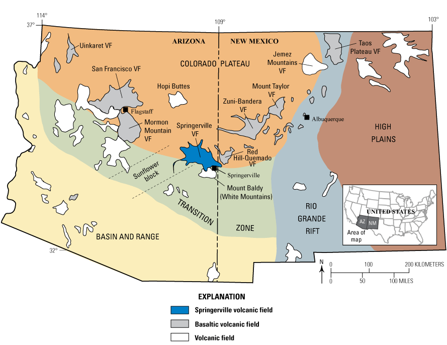
Map of the Springerville volcanic field in east-central Arizona and at the southern margin of the Colorado Plateau. Other volcanic fields and predominantly basaltic volcanic fields along the Colorado Plateau margin are also shown. Figure modified from Mnich and Condit (2018) and Condit and others (1989). VF, volcanic field.
Older trachytic lavas of the Mount Baldy shield volcano to the south, ranging in age from 9 to 7 Ma, underlie the lavas of the Springerville volcanic field (Condit and others, 1989). Additional flows that erupted between the Mount Baldy eruptions and the main eruptive events in the Springerville volcanic field include a tholeiitic flow (5.31±0.11 Ma) that covers an area of about 50 km2 along the north edge of the Springerville volcanic field. To the southeast of the Springerville volcanic field, a basanitic basal flow, dated by Laughlin and others (1979) at 3.06±0.08 Ma, forms an approximately 10 m cliff face on the west side of the Little Colorado River. There are also other minor flows ranging in age from 7.6±0.4 to 2.94±0.14 Ma at the edges of the field that range in composition from tholeiite to hawaiite (Laughlin and others, 1979; Condit and Connor, 1996).
Approximately 2,280 km2 (85 percent) of the Springerville volcanic field was mapped by Chris Condit, Larry Crumpler, and Jayne Aubele between 1978 and 1982, with the mapping continued by Mnich and Condit in 2010 and 2011, and again in 2022. The dynamic digital map of the Springerville volcanic field (Condit, 2023, and references therein) incorporates these sources of mapping and is the source for units referred to herein unless otherwise noted. The naming convention for unit symbols used herein are based on Condit (1991) and are explained in detail by Mnich and Condit (2018, and references therein). The field data are essential to the petrogenetic understanding of continental distributed volcanic fields, as such fields have long recurrence rates between eruptions, making their evolution difficult to study. Detailed mapping combined with stratigraphic and paleomagnetic data and 565 geochemical samples, collected and correlated to each of the 501 units, creates a unique opportunity to study the origin and evolution of Springerville volcanic field magmas. Methodology of this “magmatic mapping” (Condit, 1991, 2007), which focuses on distinguishing and characterizing individual magmatic events, has been discussed in detail by Mnich and Condit (2018). Results indicate varying lithologies, such that olivine-phyric, diktytaxitic, and olivine-plagioclase basalts are the most abundant, especially in older units. Younger units tend to be more evolved, such as aphyric, hornblende-bearing, or feldspathic basalts, and are typically smaller in volume.
Though stratigraphic control is relied on for determining relative ages, these units are anchored in time by 42 K-Ar ages (Condit and Connor, 1996), some of which may yield ages that are too old due to inherited mantle-derived argon (Fenton and Niederman, 2014; Duffield and others, 2006). New 40Ar/39Ar ages on three units help to further constrain temporal relations of units in the field (refer to Yellow Jacket Cienega and Morgan Mountain geographic areas in correlation of map unit charts in the dynamic digital map of Condit, 2023). Placing paleomagnetic data from 241 sites (Condit, 2023) in the geomagnetic polarity time scale of Singer (2014) provides further temporal constraints.
Approximately one-quarter of mapped lava flows (by area) are basalts with tholeiitic affinities (Condit and others, 1989, p. 7976), which are followed in areal extent by basalts transitional in chemistry between tholeiites and alkali olivine basalts (AOBs). The remaining, more evolved alkalic geochemical classes, including trachybasalts, basaltic-trachyandesites, trachyandesites, hawaiites, mugearites, basanites, and benmoreites, are smaller in areal extent. There is a distinct compositional trend through time, with early eruptions from 2–1.5 Ma dominated by tholeiitic basalts; an intermediate eruptive period from 1.5–1.0 Ma with increasing amounts of AOBs, transitional basalts, and evolved alkalic rocks; and late-stage volcanism (1.0–0.3 Ma) dominated by evolved alkalic rocks (EARs) (Mnich and Condit, 2018). These associations point to an important trend of large-volume, effusive, tholeiitic eruptions early in the lifespan of the Springerville volcanic field, progressively becoming smaller, more explosive, chemically evolved, and alkalic over time—a trend seen in the field as a whole, as well as on shorter timescales within individual vent clusters (Mnich and Condit, 2018). The intent of this study is to lay out a petrogenetic model for the Springerville volcanic field that accounts for mantle source, chemical evolution, and temporal trends seen in the field to better understand how distributed, continental volcanic fields form and evolve through time.
Melting Under the Colorado Plateau
The Colorado Plateau is an area of anomalously thick (120–150 km) lithosphere. The Springerville volcanic field overlies the lithospheric transition zone where the thick Colorado Plateau lithosphere thins to about 60–80 km in the Basin and Range Province to the south and west (Stewart, 1980; Eaton, 1982; Wernicke and others, 1982; Hamilton, 1987; Zandt and others, 1995; Sine and others, 2008; Levander and others, 2011). The lithospheric mantle of the Colorado Plateau is presumed to be fairly depleted based on xenolith compositions (Lee and others, 2001; Condie and others, 2004; Li and others, 2008), but more fertile than harzburgite (Rudzitis and others, 2016). Shallow subduction of the Farallon Plate during the Laramide orogeny between 80 and 40 Ma (Saleeby, 2003) may have metasomatized the Colorado Plateau lithosphere or introduced sediments or metabasalts at the lithospheric base (Elkins-Tanton, 2007), although Reid and others (2012) have concluded that subducted sediments either foundered during the Laramide orogeny or simply do not contribute to the lavas of the Colorado Plateau.
Melting in the Colorado Plateau region has been proposed to occur by several mechanisms. Temperatures of generation for Colorado Plateau basalts are between 1,340 and 1,500 °C (Lee and others, 2009; Reid and others, 2012; Rudzitis and others, 2016) and are hotter than midocean ridge basalts at 1,280 to 1,400 °C (Putirka, 2008a; Dalton and others, 2014; Bao and others, 2022). These high temperatures are possibly due to the insulating effect of the thickened lithosphere (Lenardic and others, 2005) or return flow in the mantle related to the past subduction of the Farallon Plate (Moucha and others, 2008). Thermal relaxation of lithosphere altered by fluids or sediment next to a warmer asthenosphere would promote melting (for example, Roy and others, 2009; van Wijk and others, 2010). A fluid- or sediment-rich mantle domain would facilitate edge-driven convection (Ballmer and others, 2015), a mechanism that is invoked for melting beneath the Colorado Plateau (Reid and others, 2012). Downwelling of a refertilized, hydrated lithosphere and subsequent return flow of the asthenosphere could play a role in generating melts (for instance, Elkins-Tanton, 2007; van Wijk and others, 2010; Levander and others, 2011). The margins of the Colorado Plateau are characterized by slow P- and S-wave velocities to depths of around 200 km, which may suggest that asthenospheric melts infiltrated the lithospheric mantle or the presence of low-viscosity hydrous pockets (Sine and others, 2008; Levander and others, 2011; Crow and others, 2011; Ballmer and others, 2015).
Mantle Heterogeneity and Isotopic Reservoirs
Global mantle heterogeneity has been argued to occur at scales ranging from centimeter-sized to more than 1,000 kilometers. Zindler and Hart (1986) first proposed distinct mantle reservoirs based on Sr, Nd, and Pb isotopic ratios in oceanic basalts. Approximately 50 samples from the Springerville volcanic field have various combinations of isotopic data, which were used by Cooper and Hart (1990) to study mantle reservoirs. It was found that the lavas of the Springerville volcanic field exhibit an inverse correlation between 87Sr/86Sr and 143Nd/144Nd ratios, which overlaps with, or extends to more enriched compositions beyond, the mantle array. This requires some form of mixing between at least two distinct isotopic reservoirs, such as mixing of a component similar to prevalent mantle (PREMA) with either an enriched mantle (EMII) or a crustal component. Cooper and Hart (1990) suggested that all isotopic systems indicate at least two-component mixing, but they also suggest the addition of at least one additional component. They define a depleted reservoir, M1 (similar to a PREMA component), an enriched component, M2 (similar to an EMI reservoir), and an M3 reservoir trending toward HIMU (a high 238U/204Pb reservoir). The tholeiitic lavas of the Springerville volcanic field show a wide range of trace elements that do not correlate with isotopes, which suggests either an enriched mantle source or crustal contamination of an M2 component. It is also possible that M2 represents a crustal reservoir that contaminates the mixing array of M1 and M3, resulting in transitional basalts. In this case, however, tholeiitic lavas would also be produced by mixing of M1 and M3, but with contamination of another distinct crustal component. The M1 (PREMA) reservoir corresponds in composition with the evolved alkalic basalts and is believed to represent an asthenospheric mantle source. Residing at shallower depths, the M2 reservoir likely represents lithospheric mantle, as evidenced by chemical and isotopic data from xenoliths and other extrusive rocks (Cooper and Hart, 1990).
Methods
Choosing a Representative Suite of Samples
Of the 501 units of the Springerville volcanic field mapped prior to 2022, 311 units were characterized by major element geochemistry, as described in detail by Mnich and Condit (2018). Of these 311 units, 135 have more than one sample with major element geochemistry. To avoid bias in the interpretation of the dataset, a single representative sample was chosen for each unit, with the exception of a large composite, diktytaxitic unit on the western side of the field (unit QTsf of Condit, 1991), the largest unit by area in the field, where two samples were chosen to represent the distinct upper and lower flow sheets. A representative sample was chosen using several criteria. The first, and arguably the most important, is the consistency of the geochemical data with the other samples from the unit. A sample that is definitively located within the unit or in a more proximal position to the vent is preferred over those on boundaries. If there are multiple samples from the same unit that cannot be distinguished by any of the previously mentioned criteria, the availability of other geochemical data, including trace element and isotopic data, is used to choose a representative sample. The representative suite consists of 311 major element analyses, each representing a distinct unit, except for the two samples from unit QTsf.
Identifying Primitive Magma
A goal of this study is to assess the derivation of magmas from the source region, which requires primitive magmas. To assess the effects of fractional crystallization on the Springerville volcanic field samples, relations between MgO, CaO/Al2O3, and Sc were evaluated (fig. 2). MgO concentration in a melt is sensitive to removal of olivine, clinopyroxene, and orthopyroxene, whereas CaO and Sc concentrations are affected by fractional crystallization of clinopyroxene. The relations shown in figure 2 suggest that both olivine and clinopyroxene fractional crystallization may play a role in the petrogenesis of these lavas. Samples with more than 8.5 weight percent MgO were chosen for the primitive suite to assess mantle source, which is slightly higher than the lower limit of 8 weight percent MgO suggested for primary magmas by Leeman (2020) and Mullen and others (2017).
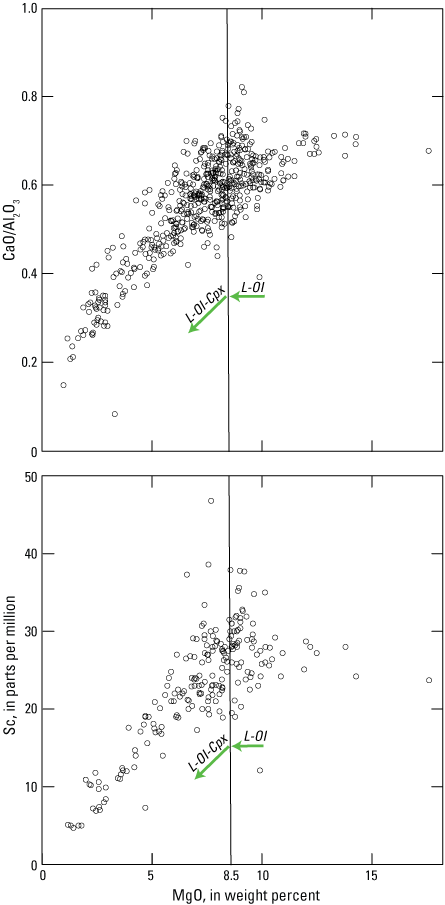
Plot of CaO/Al2O3 ratio versus MgO concentration (top) for all samples in the Springerville volcanic field, and plot of Sc versus MgO concentration (bottom) for all samples with available data. The arrows indicate the fractionation trends of olivine (L-Ol) and both olivine and clinopyroxene (L-Ol-Cpx). The vertical line represents 8.5 weight percent MgO, which was chosen as the cutoff for subsequent analyses that require having only olivine as a fractionating phase.
Samples with >8.5 weight percent MgO were then modeled using pMELTs to determine if olivine is the only fractionating phase (Ghiorso and Sack, 1995; Asimow and Ghiorso, 1998; Ghiorso and others, 2002). Of the 311 representative Springerville volcanic field samples with major element geochemical analyses, 98 were presumed to have evolved along an olivine-controlled trend (the primitive suite) and have Mg# ranging from 57.6 to 74.4. Of these 98 samples, 62 have only olivine as a phenocryst present (ranging from 2 to >11 percent olivine). Ten samples have olivine and pyroxene, 15 have olivine and plagioclase, and 4 have olivine, pyroxene, and plagioclase. The remaining 7 samples have minimal (<2 percent) to no olivine. Samples with phenocryst assemblages other than just olivine may not be ideal but are included because they meet all the geochemical criteria. One such criterion for a primitive magma is Ni greater than 100 parts per million (ppm). Of the 98 samples, 49 were analyzed for Ni, which ranges from 111 to 507 ppm, with the exception of two samples from olivine-pyroxene basalt flows (units Qla3 and Qsa1) that both have 71 ppm Ni. These two samples were included in the primitive dataset due to their high Mg#, 64.6 and 68.1, respectively. All samples have Cr values >200 ppm, except the sample from a basanite unit (Qla3) at 120 ppm which was still included in the primitive dataset.
Thermobarometry
Silica activity-based thermobarometers for igneous processes have been developed beginning with Carmichael and others (1970) and Nicholls and others (1971). The pressure and temperature of magma generation for the Springerville volcanic field samples were estimated using the silica activity-based technique of Lee and others (2009). This process depends on olivine being the only fractionating phase, so only samples from the primary suite were utilized (refer to the “Identifying Primitive Magma” section). Compositions were tested using the Ni-NiO and quartz-fayalite-magnetite buffer, and the results did not vary greatly between these two buffers. The primary compositions for the primitive datasets were used to determine pressure and temperature of generation in both the thermobarometer of Lee and others (2009) and of Putirka (2008b) for comparative purposes.
Results
When plotted on the total-alkali versus silica diagram of Le Maitre and others (1989; based on Le Bas and others, 1986) (fig. 3), the representative suite of samples from the Springerville volcanic field predominantly plot in the basalt field, including tholeiites, transitional basalts, and alkali olivine basalts (AOBs). One hundred and thirteen samples are chemically evolved alkalic rocks (EARs), plotting both within the sodic and potassic geochemical classes, including trachybasalts, hawaiites, basaltic-trachyandesites, mugearites, trachyandesites, and benmoreites, whereas 7 are low-SiO2 basanites.
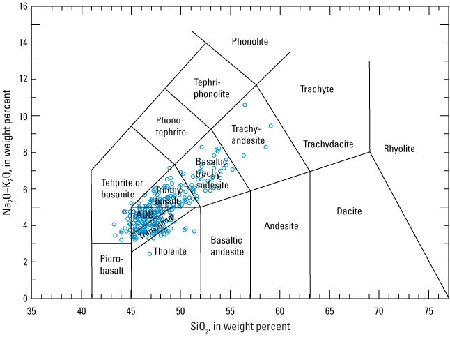
Total-alkali versus silica diagram (Le Maitre, 1989) for the representative suite of samples in the Springerville volcanic field. AOB, alkali olivine basalt.
Thermobarometry Results
The 98 primitive samples, identified in the “Identifying Primitive Magma” section, with MgO >8.5 weight percent and determined to be on an olivine-controlled fractional crystallization trend, were used to calculate pressures and temperatures of melt generation using the thermobarometric techniques of Lee and others (2009). Calculated temperatures range from 1,420 to 1,600 °C, with pressures ranging from 2.2 to 4.7 gigapascals (GPa) (about 75 to 150 km depth), corresponding to regions at and below the lithosphere-asthenosphere boundary. Model uncertainty is estimated at ±0.20 GPa (about 2 standard deviations) and ±3 percent for temperature (Lee and others, 2009). The spinel-garnet transition is inferred to occur at pressures of 2.7–3 GPa, suggesting Springerville volcanic field magmas are derived from both spinel- and garnet-bearing source regions (Robinson and Wood, 1998). Results are fairly consistent with previous estimates for Colorado Plateau melt equilibration of 1,340–1,500 °C and ≤3.5 GPa (Lee and others, 2009; Reid and others, 2012; Rudzitis and others, 2016).
The Lee and others (2009) barometer has been tested against another silica activity-based barometer from Putirka (2008b) (fig. 4). Relative to experimental data, it was determined the Lee and others (2009) model overestimated pressure for those calculated to be more than 3 GPa, whereas the Putirka (2008b) model underestimated pressure for those calculated to be more than 3.5 GPa (Putirka and others, 2012). The models show relatively good agreement at lower pressures, but samples >3 GPa diverge as much as 0.9 GPa, which cannot be accounted for by model error alone (0.29 GPa for Putirka, 2008b) and that suggests the upper pressure for melt derivation may be lower than previously reported, instead lying somewhere between about 3.76 GPa, as predicted by Putirka (2008b), and 4.7 GPa. The relative pressure trends of each geochemical class are the same with each model, so we utilize the thermobarometric results of Lee and others (2009) from here onward with the caveat that higher pressures may in fact be an overestimate.
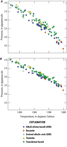
Results of thermobarometric calculations for the Springerville volcanic field primitive sample suite using the methods of, A, Lee and others (2009) and, B, Putirka (2008b).
Trends in pressures and temperatures of magma derivation, calculated from Lee and others’ (2009) model, between geochemical classes are apparent (table 1). From the EAR class, only a small subset of trachybasalts and hawaiites are included, as all others are too evolved to meet the criteria for the Lee and others (2009) model. Basanites are generated only at pressures >3 GPa (table 1, fig. 4). The AOBs span a large range but do extend to the highest temperatures and pressures. The EARs and tholeiitic samples show similar pressures and temperatures and are at the lower values of the total range in the field, although the EARs are generated from slightly higher pressure at a given temperature.
Table 1.
Melting pressure calculated for a representative primitive suite (by chemical class) of samples from the Springerville volcanic field using the methods of Lee and others (2009).[GPa, gigapascal]
The calculated pressures were plotted against approximate age of the corresponding volcanic unit to evaluate trends in depth of magma generation through time (fig. 5). Overall, the data show no discernable trend in depth of melt generation through time. Within individual geochemical classes, EAR, transitional basalts, and tholeiites show an apparent decline in pressure with age, although the limited dataset for tholeiites makes it difficult to assess the reliability of such a trend. Tholeiites also erupted in a limited time range, with none in this subset having erupted before 1.45 Ma. Though there is a range of pressures, the average stays roughly consistent throughout the lifespan of the volcanic field.
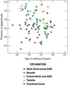
Approximate age versus pressure calculated using the thermobarometric methods of Lee and others (2009) for primitive suite samples of the Springerville volcanic field.
Early in the lifespan of the field, transitional basalts were generated at pressures as great as ~4 GPa. This time, from about 2.0 to 1.5 Ma, is also marked by the eruption of the majority of tholeiites, many of which were generated from much shallower depths than the transitional basalts. Through time, tholeiite eruptions wane, and evolved alkalic lavas become more prevalent. To further assess depth of melting through time, the calculated pressures and temperatures were plotted in 0.3 Ma intervals (fig. 6). All time intervals show fairly significant ranges in temperature and pressure, with the exception of the 2.1–1.8 Ma interval. Within this period, which is at the beginning of the eruptive history of the field, samples exhibit a fairly restricted temperature range (1,515–1,565 °C) and are all at relatively high pressures of 3–4 GPa, approximately coincident with the depth of the lithosphere-asthenosphere boundary. The samples represented in this early period are AOBs, transitional basalts, and basalts with tholeiitic affinities. Younger samples exhibit a significant spread in pressure (from 2 to >4.5 GPa) and temperature (1,400–1,600 °C) of generation, with the period from 0.9–0.6 Ma ranging from both some of the lowest pressures and temperatures of generation to the highest.
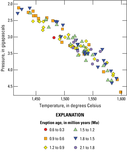
Plot of thermobarometric results calculated using the methods of Lee and others (2009) plotted by age, in 0.3 million year intervals.
Rare Earth and Trace Elements
Of the 501 total units, samples from 76 units have some rare earth element (REE) and trace element geochemical data. These data were plotted by geochemical class for AOBs, basanites, evolved alkalic rocks (EARs), tholeiites, and transitional basalts (fig. 7).
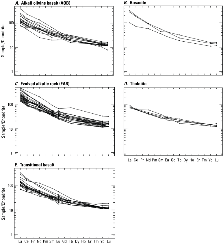
Plots of rare earth element (REE) concentration normalized to chondrite separated by geochemical class for samples from the Springerville volcanic field. Chondritic values from Sun and McDonough (1989).
REE plots show similar trends across the geochemical classes, with heavy rare earth elements (HREEs) at approximately >10 times enrichment relative to chondrite, indicating these samples did not have a garnet-rich source. Compared to the other geochemical classes, tholeiites exhibit a shallower slope, suggesting a higher degree of partial melting or derivation from a depleted mantle source. The second hypothesis, however, seems to be contradicted by isotopic constraints (see “Mantle Reservoirs” section). Lack of prominent negative Eu anomalies suggests that plagioclase fractional crystallization did not play an important role, except for in one olivine-bearing unit (Qcg3), which is chemically between tholeiites and AOBs (refer to Mnich and Condit [2018] for description of transitional units). Two AOB (units Qdg and Qwd1) and two transitional units (Qdh2 and Que1) show moderate positive Eu anomalies, suggesting the possibility of accumulated plagioclase or the assimilation of crustal gabbro. Although xenoliths are rare in the field, a gabbroic xenolith was found in vent V0404 (~3 km southwest of the sample site for a sparse olivine flow [unit Qwd1]).
To determine the mineralogy of the mantle source region, batch melting of different mantle sources was modeled for 11 samples in the primitive and representative suites that had sufficient REE data from basalt flows (units Qoa1, Tac1, Qla3, Qgl5, Qcg3, Qmb6, Qkc2, Qcd8, Qdj1, Qgl3, and QTwc). Using the partition coefficients of Rollinson (1993), spinel lherzolite, garnet lherzolite, and harzburgite (McDonough, 1990; Frey, 1980) source compositions were tested. Results from the spinel lherzolite model (57.8 percent olivine, 27 percent orthopyroxene, 11.9 percent clinopyroxene, and 3.3 percent spinel) and harzburgite model (87 percent olivine, 10 percent orthopyroxene, and 3 percent spinel) are shown in figure 8, with partial melting amounts ranging from 2 to 15 percent. The spinel lherzolite model shows good agreement in the light rare earth elements (LREEs) but is a poor match with the HREEs. The harzburgite model shows better agreement with the HREEs and agrees with prior depletion of the Colorado Plateau mantle (Lee and others, 2001; Condie and others, 2004; Li and others, 2008) but disagrees with Rudzitis and others (2016) that the mantle under Colorado Plateau is more fertile than harzburgite. It is important to note that none of the samples used were tholeiites, which show a more enriched isotopic source (see “Mantle Reservoirs” section), due to lack of data for tholeiites in the primitive suite, thus making this a cursory assessment. More data would help to better characterize the mantle source, and especially to determine if there is source variation.
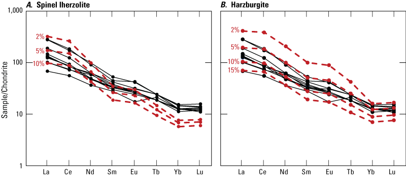
Plot of rare earth element concentrations normalized to chondrite (Sun and McDonough, 1989) for 11 Springerville volcanic field samples from basalt flows (units Qoa1, Tac1, Qla3, Qgl5, Qcg3, Qmb6, Qkc2, Qcd8, Qdj1, Qgl3, and QTwc). Red dashed lines represent 2, 5, 10, and 15 percent partial melting of a spinel lherzolite (A) and harzburgite (B) source.
The source mineralogy was compared to Zn/Fe ratios in Springerville volcanic field samples, as olivine preferentially incorporates Fe over Zn, so olivine-rich sources generate magmas with lower Zn/Fe (Le Roux and others, 2010, 2011; Rudzitis and others, 2016). A ratio of Zn/Fe of 12.5×10⁴ is the upper limit expected for a peridotite melt (Le Roux and others, 2010). Of the primitive dataset with MgO >8.5 weight percent that are more representative of the mantle source, only one sample from a transitional basalt (unit Qkb2), has Zn/Fe greater than 12.5×10⁴ (fig. 9).
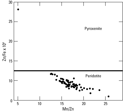
Plot of Mn/Zn versus Zn/Fe*104 for the subset of primitive samples from the Springerville volcanic field that have MgO >8.5 weight percent. All samples except for one plot below the upper limit expected for peridotite melts.
Within the representative suite, average Zn/Fe was calculated for each geochemical class. There is a small amount of variation between the geochemical classes, from 8.8×10⁴ in the basanites to >11×104 for the tholeiites. Basanites and AOBs have similar ratios of 8.87×10⁴ and 8.91×10⁴, respectively, whereas the EAR and transitional basalt samples are comparable with ratios of 10.7×10⁴ and 10.3×10⁴, respectively.
To assess the relative degree of partial melting between the different geochemical classes, Sm/Yb was plotted against La/Yb (Klein and Langmuir, 1987; Salters and Hart, 1989) (fig. 10). Tholeiites are at the low end of the range for both ratios, suggesting either higher degrees of partial melting than for magmas of other geochemical types from an identical source, or possibly a source that varies in trace element composition. Support for high degrees of melting comes from the widely accepted model for tholeiites, and that tholeiite generation in the Springerville volcanic field occurred early during periods of high heat flow. AOBs and transitional basalts show a large range of these ratios, but the majority are near the lower end, suggesting higher degrees of melting, although varying into lower degrees of melting than tholeiites. The evolved alkalic rocks have somewhat higher ratios, suggesting smaller degrees of partial melting—a model that is widely called upon for the generation of alkalic rocks. Interestingly, the basanites seem to generally have the highest ratios in the field, with only one exception. This may be an artifact of the relatively small sample size of basanites with REE data, but it suggests that basanites are generated at great depths by small degrees of partial melting, or potentially by a source region more enriched in LREEs.
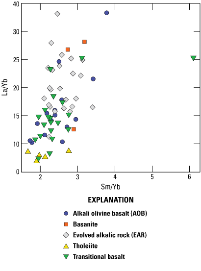
Plot of La/Yb ratio (light over heavy rare earth element) versus Sm/Yb ratio (middle over heavy rare earth element) for samples from the Springerville volcanic field with available trace element data.
Heat Production
The trends observed between thermobarometry calculations and degree of partial melting suggest changes occurred in overall heat production of the Springerville volcanic field. Tanaka and others (1986) estimated heat production in the San Francisco Volcanic Field based on eruptive volumes and a heat content for basalts of 400 calories per cubic centimeter (cal/cm3). In the Springerville volcanic field, eruptive volumes are approximated using exposed areal percentages of eruptive units and extrapolating that to volumes based on the total field volume estimate of 300 km3 of Condit and others (1989). The volumetric eruptive rates calculated over 0.25 million year (m.y.) intervals are shown in table 2. These estimates are based on the interpreted areal percentages to include the additional extrapolated volume of unit QTsf, the large, diktytaxitic flow on the western side of the field, that has partially been covered by younger flows and emanated from spatter-rich cinder cones, the latter of which are found almost exclusively in the western parts of the field (Mnich and Condit, 2018). Heat productivity is inferred to be higher in the early main stages of the Springerville volcanic field beginning at about 2 Ma, when the eruptive volumes are greater (fig. 11). Heat production then stayed fairly constant from 1.5 to 0.75 Ma, until it began to wane later in the lifespan of the field.
Table 2.
Estimated volumetric eruptive rates and heat production for 0.25 million year intervals during the lifespan of the Springerville volcanic field.[cal/yr, calorie per year; J/yr, joule per year; km3, cubic kilometer; km3/yr, cubic kilometer per year; Ma, mega-annum]
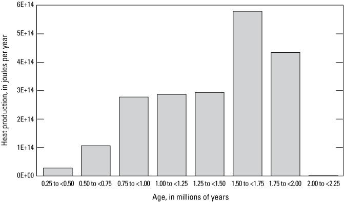
Plot of approximated heat production in the Springerville volcanic field through time in 0.25 million year intervals. The interval from 2 to 2.25 million years ago (Ma) has heat production 2–3 orders of magnitude smaller than the other time intervals and therefore does not register on this plot.
The highest rates of vent production are during the 1.5–1 Ma time interval, notably later than the intervals with the highest heat production in the field (Connor and others, 1992; Condit and Connor, 1996). The first possibility for this discrepancy could simply be that early vents were destroyed or covered by younger flows. The second option is that early intervals saw large-volume, less-explosive flows, while later changes in magma chemistry and perhaps volatile content produced more discrete explosive vent-forming eruptions, with smaller volume lava flows. The generation of early, fluid, high-volume tholeiitic flows in the western part of the field, and the trend toward lower volume and more evolved alkalic lavas (Mnich and Condit, 2018), support the second option.
Eruption Locations and Their Relation to Geochemical, Temporal, and Geophysical Properties
A general shift in volcanism from west to east across the Springerville volcanic field through time has been noted previously (Condit and others, 1989; Condit and Connor, 1996). Connor and others (1992), using a spatial-temporal cluster analysis algorithm, showed that vents could be parsed into seven clusters, with a pattern of cluster age decreasing to the east. Their applications of the two-point azimuth and Hough transform methods demonstrate that regional cinder cone alignments transect these clusters, with orientations that may be related to extension resulting from plateau uplift and a minor Basin and Range imprint (fig. 12).
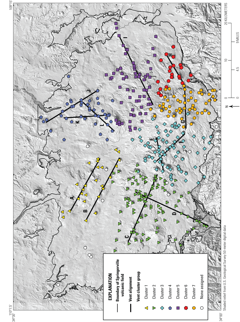
Map of the Springerville volcanic field showing 7 vent cluster groups and 12 vent alignments (lettered A through L) as defined by Connor and others (1992). Point markers indicate vents and are colored by eruptive cluster.
Using gravity data and the derived density model, Deng and others (2017) related patterns of volcanic activity in the Springerville volcanic field to relict blocks of Proterozoic crust with varying physical properties. Boundaries between these crustal blocks trend to the northeast. High vent density and vent alignments correspond to areas of high crustal density gradient; thus, vent alignments tend to parallel the interface between blocks of different densities, in areas where the density and gravity changes are the highest (Deng and others, 2017). Using two- and three-dimensional numerical models of magma ascent through these crustal blocks of differing densities to simulate long-term, average magma migration, Deng and others (2017) suggested that changes in model diffusivity and bulk lithosphere properties can simulate magma migration paths and alter magma flux, implying that crustal structures, such as inherited tectonic block boundaries, influenced magma ascent, and therefore the clustering and alignment of volcanic vents in the field. Their model lacks geochemical or age progression data but does show that underlying crustal structure affects the spatial distribution of vents and may ultimately affect other characteristics of the field.
Of the 420 recognized vents in the Springerville volcanic field, 241 are characterized by geochemistry. The distribution of vents of known geochemical class was plotted on the gravity and density data of Deng and others (2017); one plot for all the vents with geochemical data (fig. 13A), and a second plot showing only vents of primitive compositions (fig. 13B) (87 total, thus making it a subset of the 98 primitive samples, one per eruptive unit, of table 1). In agreement with Deng and others’ (2017) results, with the exception of four vents in the far north-central part of the field (two with transitional chemistry, one EAR and one with no chemistry), vents are not located in areas of high, positive density contrast, suggesting that magma ascent is difficult in those areas. Vent alignments correspond with steep changes in gravity. AOB samples tend be in areas of high gravity gradients, perhaps at the boundaries between different crustal blocks. The basanite sample size is limited, but basanite vents tend to form in areas of moderately low density. The EAR samples from the primitive suite, except for one sample, plot along a southwest-northeast-trending line of high gravity gradient. Tholeiitic samples are located in areas of slightly higher density and, unlike the other geochemical classes, do not appear in places where the density contrast is lowest. Transitional basalt vents plot in low to moderate density contrast areas, similar to AOB and EAR classes. Vents not characterized chemically are shown on these plots in the background as black triangles. A more robust dataset from these vents with associated flows (approximately 90 additional vents) may offer an opportunity to better understand these spatially controlled petrogenetic patterns.
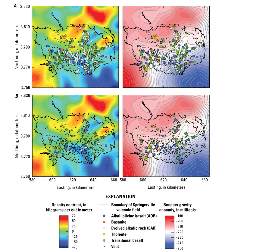
Maps of the Springerville volcanic field showing all vents with geochemical data (A) and vents of the primitive suite (> 8.5 weight percent MgO) of samples (B) by geochemical class superposed on the density (left) and gravity (right) models of Deng and others (2017). Vents not characterized chemically are shown as black triangles.
A similar comparison of the location, vent spatial density, and gravity was done using the age of the primary vents, plotted in 0.25 m.y. intervals (fig. 14). The oldest samples (in the 2–1.75 Ma and 1.75–1.5 Ma age intervals) are predominantly concentrated in the southwest part of the field, perhaps because older primary vents have been buried under younger lavas elsewhere. As time progresses, the vent locations become more dispersed and extend to the more easterly parts of the field. In the samples that are less than 1 Ma, the vents are aligned along two lineaments, trending southwest-northeast and north-south (alignments I and K of Connor and others, 1992; fig. 12); this is especially evident in the 1.0–0.75 Ma samples. Perhaps the ascent of primary magmas, late in the life of the field when overall magmatism was waning, required more favorable conditions to erupt, as might be found along existing fault zones or the edges of Proterozoic structural blocks.

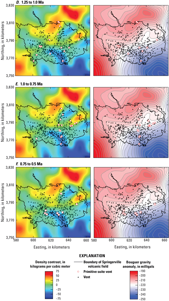
Maps of the Springerville volcanic field showing vents of the primitive suite (>8.5 weight percent MgO) for three 0.25-million-year-long intervals superposed on the density (left) and gravity (right) models of Deng and others (2017). Vents not characterized chemically are shown as black triangles. A, 2.0 to 1.75 mega-annum (Ma). B, 1.75 to 1.5 Ma. C, 1.5 to 1.25 Ma. D, 1.25 to 1.0 Ma. E, 1.0 to 0.75 Ma., F, 0.75 to 0.5 Ma.
A comparison of the vent locations with the depths from which these 87 primary magmas were derived (refer to “Thermobarometry Results” section) shows a tendency for magmas erupted from vents in close proximity to be derived from similar depths. Shallower melt sources are found in the southwestern and western parts of the field, coincidental with the location of early erupted magmas with tholeiitic affinities in that area (fig. 15). Shallower magma sources are also scattered in a north-south pattern in the topographically highest part of the field, centered in the Greens Peak area—a location that also tends to host younger and more evolved magmas, many not included in the primitive suite. The easternmost vent alignment (alignment I of Connor and others, 1992; fig. 12), which extends more than 20 km to the east-northeast, hosts magmas from shallow depths and also parallels a steep gravity gradient (Deng and others, 2017), as does alignment D in the southwest part of the field. In the west-central part of the field, the eastern part of west-northwest alignment C, which has magmas from pressures between 4 and 5 GPa, coincides with an area of low-density contrast.
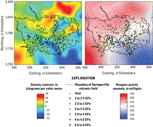
Maps of the Springerville volcanic field showing vents of the primitive suite (>8.5 weight percent MgO) by the calculated pressure of magma generation superposed on the density (left) and gravity (right) models of Deng and others (2017). Vents not characterized chemically are shown as black triangles.
Mantle Reservoirs
As previously discussed, Cooper and Hart (1990) suggested that three distinct, large-scale, mantle reservoirs likely contributed to Springerville volcanic field lavas. When compared to known isotopic reservoirs, Springerville volcanic field lavas suggest a component of the PREMA reservoir in all isotopic systems, with additional inputs of enriched mantle (EM) components (EMI and [or] EMII) (fig. 16). PREMA agrees with the M1 reservoir denoted by Cooper and Hart (1990); however, they also suggested interplay of an EMI type reservoir (M2) and another reservoir trending toward HIMU (M3). It could be argued that the data trend slightly toward HIMU, but it is more likely that lavas can be explained along mixing lines between PREMA and the enriched components, EMI and EMII. The tholeiites trend more toward the enriched end members and possibly represent a distinct end member in terms of source region. Previous studies suggest that increasing Nd isotopic ratios indicate increasing amounts of an asthenospheric component (for example, DePaolo and Daley, 2000; Crow and others, 2011). As shown in figure 16, the tholeiites have the lowest 143Nd/144Nd ratio, suggesting a smaller asthenospheric component.
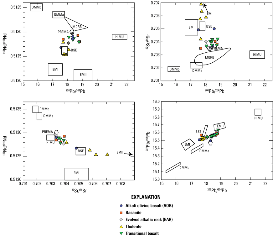
Plots of isotopic data for the Springerville volcanic field plotted relative to inferred mantle reservoirs (Zindler and Hart, 1986). BSE, bulk silicate earth; DMMa and DMMb, two depleted mantle reservoirs; EMI and EMII, two enriched mantle reservoirs; HIMU, a high 238U/204Pb reservoir; MORB, midocean ridge basalt; PREMA, prevalent mantle reservoir.
In terms of trace elements, EM basalts have a distinct signature, including high Rb/La, Ba/La, Th/U, and Rb/Sr, but low Nb/La (Wilbolde and Stracke, 2006). Table 3 contains the average trace element ratios for each geochemical class for the representative suite. Based on these data, tholeiites have high Rb/La, Ba/La, and Rb/Sr, but low Nb/La, further suggesting an EM source. Compared to the other geochemical classes, the average Th/U ratio of the tholeiitic-like basalts is moderate, whereas it is expected to be high for EM-signature basalts. Contrary to the tholeiites, basanites have low Th/U and Rb/Sr. Interestingly, the Ba/La ratio of the basanites and the tholeiites is similar.
Table 3.
Average trace element ratios for each geochemical class of the Springerville volcanic field.The Zr/Ba ratio has been used as a proxy for isotopic data (Cooper and Hart, 1990). The basanite samples have the lowest Zr/Ba on average, whereas the more evolved alkalic samples (EARs) have the highest, although many of the EARs considered are not primitive. Elevated La/Nb indicates partial melting of lithospheric mantle relative to asthenospheric melts (for example, Fitton and others, 1988, 1991; Rogers and others, 1995; DePaolo and Daley, 2000). Springerville volcanic field sample values are within the range typical of asthenospheric melts (about 0.7; DePaolo and Daley, 2000) and are expected for Colorado Plateau magmas (Fitton and others, 1988) (fig. 17). One EAR sample (unit Qyf1) has an elevated La/Nb of 2.65, which suggests a lithospheric component; however, it is important to note that, like several of the samples plotted in figure 17, the source is not primitive. Although an expanded dataset could facilitate a better understanding, current La/Nb data suggest an asthenospheric source, similar to what is suggested by thermobarometric data (see “Thermobarometry” section). Tholeiites, the presumed average shallowest magma class, are poorly represented in the current dataset; only one tholeiite is isolated in La/Nb versus Zr/Ba space and distinct from the basanites, which have a much lower Zr/Ba ratio (fig. 17).
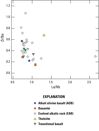
Plot of La/Nb versus Zr/Ba for Springerville volcanic field samples by geochemical class.
Discussion
Results suggest a relatively depleted (slightly more fertile than harzburgite) asthenospheric source for a subset of Springerville volcanic field lavas. Further trace element, REE, and isotopic systematics could confirm this interpretation. Thermobarometric results suggest that melting in the Springerville volcanic field originated at 2.1 Ma at pressures of about 3–3.5 GPa (approximately 100–115 km depth) and temperatures between 1,515 and 1,565 °C. These depths are roughly coincident with the lithosphere-asthenosphere boundary under this region of the Colorado Plateau. A large early pulse of volcanism from around 2–1.5 Ma caused significant melting and the generation of large-volume tholeiitic lava flows. Thermobarometry indicates that tholeiites are derived at lower pressures than several of the other geochemical classes, perhaps in the lithospheric mantle (fig. 4). AOB, transitional, and basanitic magmas were generated at fairly constant volumes through time until a substantial decline in heat began at 1 Ma. AOBs and transitional basalts span a wide range of temperatures and pressures, from some of the lowest pressures in the field (about 2.1 GPa) to some of the highest (about 4.39 GPa). Basanites are distinct in that thermobarometry suggests they are consistently derived from very high pressures, with average depths of generation at nearly 140 km, although the model of Putirka (2008b) suggests this might be an overestimate. Three-dimensional spatial patterns of magma generation are shown by geochemical class in figure 18. An interactive version of the plot shown in figure 18 is available at https://doi.org/10.3133/pp1890N.
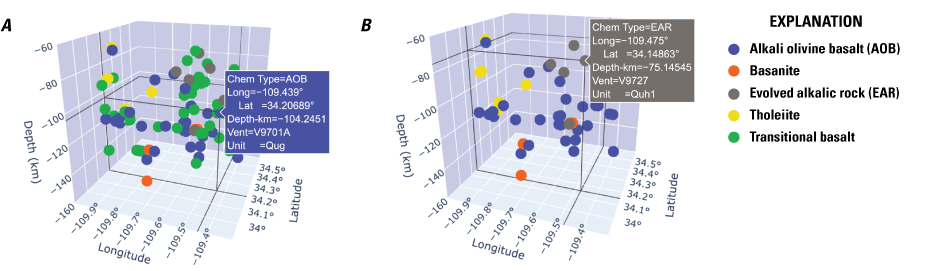
Screenshots of two three-dimensional plots showing longitude and latitude versus depth of initial melting for primitive suite samples with known vent locations in the Springerville volcanic field. A, Full dataset. B, Dataset with the transitional basalt geochemical class (between alkali olivine basalts [AOB] and tholeiites) omitted to better view the end-member chemical classes. Interactive plot is available at https://doi.org/10.3133/pp1890N, where users can rotate the plot, add and remove geochemical classes, and inspect data points (as shown in the blue and gray pop-up descriptions) for different views and more information.
The rise in evolved alkalic lavas (EARs) beginning at about 1.5 Ma is coincident with a change from large-volume flows to higher rates of pyroclastic vent production and smaller-area flows. EAR samples overlap in temperature-pressure space with the tholeiites; however, at any given pressure, they are generated at lower temperatures, likely suggesting smaller degrees of partial melting (assuming the same source composition). It is important to note that the pressures and temperatures calculated using this thermobarometric method are approximate and based on several assumptions. The first is that olivine is the only fractionating phase. The use of samples that have more than 8.5 weight percent MgO gives higher likelihood that magmas are fractionating only olivine, but this is not necessarily the case, as plagioclase feldspar and clinopyroxene phenocrysts are not uncommon in these rocks. If plagioclase is co-crystallizing, the calculated temperature and pressure would be erroneously high due to an overestimate of SiO2 and MgO. The opposite is true if clinopyroxene is crystallizing, as SiO2 would be underestimated and MgO overestimated, causing lower pressure and higher temperature results. As noted previously, testing to determine if the samples are chemically along an olivine-controlled trend in pMELTS addresses this assumption. The second assumption is that the calculated primary magma compositions are in equilibrium with a mantle composition, with Mg#=0.9. If mantle residuum is in fact greater than Mg#=0.9, temperatures and pressures are underestimated, whereas if the Mg# is less than 0.9, calculated values would be higher than true values (Lee and others, 2009). Comparison to the Putirka (2008b) model suggests that pressures >3 GPa may be overestimates (fig. 4). Water or CO2 are not taken into consideration in these calculations, but there is evidence that Colorado Plateau lavas are derived from relatively anhydrous source regions, with magma water contents believed to ubiquitously be less than 0.5 weight percent (Li and others, 2008). Fourier transform infrared (FTIR) spectroscopic analyses on melt inclusions for a small subset of 5 samples in the Springerville volcanic field agree with water-poor magmas, yielding average water values all less than 0.5 percent (Mnich, 2019). The resultant temperatures and pressures are therefore good first-order approximations but should not be taken as absolute.
Based on REEs ratios (La/Yb and Sm/Yb), basanites and EARs are seemingly generated at low degrees (about 5–10 percent) of partial melting. The small sample size for basanites with REE data (3 samples out of 7 total basanites) perhaps makes this trend less reliable, especially since one of the data points plots at lower ratios. Although there is a range for the AOB and transitional samples, they mostly have La/Yb and Sm/Yb ratios, suggesting higher degrees of partial melting of the same source than the basanites or EAR samples, though at lower degrees than the tholeiites. It is important to note that the interpretation of these ratios also relies on having a source region that is relatively homogeneous in these trace elements. Whereas the inferred high degree of partial melting is consistent with the large-volume tholeiites, moderately high amounts for the AOBs and transitional classes, and lower degrees for the smaller volume, more evolved alkalic units, the basanite ratios may reflect variability in source composition. Two of the three basanites have higher La/Yb and Sm/Yb ratios, possibly implying a distinct source area with variable trace element ratios, perhaps located very deep. However, isotopic ratios for the basanites do not vary significantly from the AOB, transitional, and EAR classes, suggesting a similar source, perhaps, though varying in mineralogy and (or) trace elements. Previous work has suggested that melting of carbonated garnet lherzolite can produce silica-undersaturated basanitic melts with higher Sm/Yb ratios (Dasgupta and others, 2007; Gerbode and Dasgupta, 2010; Zeng and others, 2017). Basanite generation may reflect the melting of residual CO2-rich pockets within the garnet stability zone of the asthenosphere. Melt modeling (fig. 8) suggested a garnet-free mantle source but is a limited representation of the basanites. CO2-rich pockets would also have implications for the facilitation of shear-driven upwelling in the lithosphere (Ballmer and others, 2015). High CO2 areas would affect thermobarometric estimations, because the model of Lee and others (2009) is not calibrated to include the effects of CO2 on silica activity, potentially suggesting that basanites are actually generated at lower pressures and higher temperatures than the calculated values.
Isotopic systems suggest the interplay between two end-member mantle sources similar to PREMA and EM mantle reservoirs (fig. 16). Tholeiites are isotopically distinct and contain much more of an EMII component. If sediment input was responsible, 206Pb/204Pb >18.5 would be expected (Plank and Langmuir, 1998; Usui and others, 2006), which is not the case. The Zn/Fe ratio would also be elevated if olivine-poor sediments were incorporated into the source region, and though the Zn/Fe ratio for tholeiites is slightly higher than the rest of the geochemical classes, it is still within the range expected for olivine-bearing melts. The lack of sediment input is in agreement with Reid and others (2012), who concluded that sediments subducted during the Laramide orogeny do not play a role in magma generation in the Colorado Plateau region. It has been suggested that the EM reservoir can be derived from lithospheric mantle (for example, Chung and others, 1995). This agrees well with the thermobarometric data, suggesting an average depth of magma generation of the tholeiites of approximately 90 km depth (ranging as shallow as 70 km) but is not suggested by La/Nb, although more data are needed to assess La/Nb. With the exception of one sample (unit Qsa1), the depth of tholeiite generation decreases to the south, possibly as a result of a thinning lithosphere closer to the Basin and Range Province. The small dataset of six tholeiitic units with pressure calculations is possibly a limiting factor in this interpretation; further, only three of these units have documented vent locations.
The deeper basanites, AOBs, and transitional basalts have a PREMA-reservoir-dominated source region, likely located within the asthenospheric mantle, similar to the M1 reservoir defined by Cooper and Hart (1990). The overall limited amount of isotopic data currently available in the Springerville volcanic field may also be a limiting factor in ascertaining mantle heterogeneity. A total of 61 samples are characterized by at least one isotopic ratio; 39 have Pb data, 55 have Sr data, and 20 have Nd data. The lack of a uniform suite of isotopic data for the entire sample set limits our ability to definitively assess their reservoir of origin. Tholeiites and basanites are both limited but are clearly end-members of importance that could benefit from further characterization.
Alkalic rocks are commonly presumed to be generated from small degrees of partial melting at greater depths (for example, Green and Ringwood, 1967; Gast, 1968; Kushiro, 1968). Although the more primitive of the Springerville volcanic field EAR samples (>8.5 weight percent MgO) do seem to be generated by small degrees of partial melting, pressure calculations suggest depths of magma equilibration that are shallower and more similar to the tholeiitic samples (figs. 4 and 18).
Smaller degrees of partial melting of the same lithospheric source of tholeiites can be ruled out owing to the distinct isotopic signatures of tholeiites. There is limited thermobarometric data for the more evolved alkalic rock types, as the majority are too evolved to be used in the calculations, perhaps making their relatively shallow depth of origin a less reliable interpretation. EARs show evidence of some degree of fractional crystallization at shallow levels, possibly in crustal reservoirs at 0–12 and 23–30 km depths, as suggested by Putirka and Condit (2003) based on equilibrium calculations from clinopyroxene-whole-rock pairs from 32 units in the western part of the field, of which 5 were EARs. As discussed previously, P- and S-wave velocities in the Colorado Plateau region could be explained by infiltration of asthenospheric melts in the lithosphere (Sine and others, 2008; Levander and others, 2011; Crow and others, 2011). The influx of low SiO2 basanite melts from the asthenosphere into the lithosphere would facilitate mixing between basanite and tholeiitic melts. Zeng and others (2017) described how a similar mixing scenario could trigger crystallization of garnet and clinopyroxene and result in the formation of a SiO2 saturated alkaline magma according to the reaction:
The occurrence of this reaction in the lithospheric mantle is consistent with the trend of early eruptions of tholeiitic lavas that drop off around 1.5 Ma, giving rise to significantly more evolved alkalic lavas (EARs) after that time, presumably after mixing occurs. Although basanitic lavas are relatively uncommon at the surface, representing only 3.6 percent of the total areal extent of lavas, the flows are fairly large in area, with an average unit size of 12.3 km2. This flow size is nearly twice as large as the average for the EAR subgroup (5.6 km2), and more than twice as large as AOB and transitional units. Basanitic units are not as large as tholeiites, which average 35.7 km2 per unit, but their relatively large size suggests that volumetrically large batches of magma are generated in the asthenosphere. More isotopic data could help to determine if these EARs lie on a mixing line between tholeiites and basanites.
Generation of alkalic magmas at relatively shallow depths can also occur by melting of metasomatized mantle in the presence of CO2 (Pilet, 2015). Minor amounts of CO2 of only a few hundreds of parts per million decrease the solidus temperature of peridotite (Katz and others, 2003; Asimow and others, 2004; Dasgupta and others, 2007). The production of alkalic lavas in the presence of CO2 and the resultant depression of the solidus temperature agrees with the thermobarometric results that indicate, for a given pressure, alkalic magmas are produced at lower temperatures than tholeiitic magmas. Although it is plausible that early, possibly carbonated, asthenospheric melts could progressively interact with and metasomatize the overlying mantle, creating conditions for the shallow generation of alkalic magmas, this process commonly creates SiO2-undersaturated magmas, which is not the case for the EAR geochemical classes in the Springerville volcanic field (Dasgupta and Hirschmann, 2007).
Conclusions
In the late Pliocene, as the southern tip of the Colorado Plateau interfingered with the Basin and Range Province and the lithosphere thinned over the upwelling asthenosphere, the resulting heat flow spawned relatively high degrees of shallow partial melting, giving rise to the voluminous effusive tholeiitic eruptions that marked the birth of the Springerville volcanic field. Extensive field, geochemical, and relative age data provide the framework for understanding the development and evolution of this distributed volcanic field through time. Thermobarometric data derived from primitive (>8.5 weight percent MgO), olivine-controlled samples indicate this early melting was relatively shallow (70–90 km), in olivine-bearing, somewhat-depleted spinel lherzolite or harzburgite near the thinning lithosphere-asthenosphere boundary. The enriched mantle (EM) isotopic signature of tholeiites and trace element compositions suggest a chemically distinct mantle source for the tholeiites, perhaps coincident with lithospheric mantle. Early melting also occurred deeper in the asthenosphere, generating the isotopically prevalent mantle (PREMA)-like basanite, alkali olivine basalt (AOB), and transitional classes. More isotopic data are needed to better determine distinctions in source regions for different geochemical classes. Evidence suggests that basanites were generated from residual CO2-rich pods as deep as 140 km in the asthenosphere. AOB and transitional lavas were likely generated in uncarbonated asthenospheric mantle, which produced a similar isotopic signature to the basanites without the same degree of silica undersaturation. Basanites represent an isotopic end member more consistent with a PREMA-like mantle source; EM-sourced tholeiites represent the other end member, and all other geochemical classes fall in between. Thermobarometry agrees with the generation of most of the AOBs and transitional basalts at pressures of about 3 GPa, although some are shallower, suggesting possible temporary re-equilibration in the lithosphere, potentially related to structural controls, including mantle heterogeneity inherited from the different Proterozoic blocks that underlie the field.
As heat production waned, reaching steady state flow in the field’s mid-life from 1.5 to 1.0 Ma, the eruption of tholeiitic magmas also waned, yielding to the deeper, asthenosphere-sourced basanites, AOBs, and transitional magmas. More evolved alkalic magmas became much more abundant as heat flow waned toward the end of the field’s lifespan. Infiltration of asthenospheric, basanitic magmas to the shallower depths of tholeiite generation led to a mixing of basanite and tholeiite magmas, which could have generated the late-stage, shallow parental magmas of evolved alkalic rocks (EARs). The later-stage shift to more evolved magmas produced lower volume flows and more explosive eruptions, most notably in the EARs and AOBs, a field-wide pattern also noted in the seven vent clusters (fig. 12) identified by Condit and Connor (1996). With lower heat input, eruptions become more localized, likely related to structural controls, such that vent alignments identified by Connor and others (1992) correspond to steep changes in gravity (Deng and others, 2017) between blocks of Proterozoic crust, suggesting these blocks have different properties that control the efficacy of magma ascent in each.
References Cited
Asimow, P.D., and Ghiorso, M.S., 1998, Algorithmic modifications extending MELTS to calculate subsolidus phase relations: American Mineralogist, v. 83, nos. 9–10, p. 1127–1132, https://doi.org/10.2138/am-1998-9-1022.
Ballmer, M.D., Conrad, C.P., Smith, E.I., and Johnsen, R., 2015, Intraplate volcanism at the edges of the Colorado Plateau sustained by a combination of triggered edge-driven convection and shear-driven upwelling: Geochemistry, Geophysics, Geosystems, v. 16, no. 2, p. 366–379, https://doi.org/10.1002/2014GC005641.
Bao, X., Lithgow-Bertelloni, C.R., Jackson, M.G., and Romanowicz, B., 2022, On the relative temperatures of Earth’s volcanic hotspots and mid-ocean ridges: Science, v. 375, no. 6576, p. 57–61, https://doi.org/10.1126/science.abj8944.
Chung, S.-L., Jahn, B.-M., Chen, S.-J., Lee, T., and Chen, C.-H., 1995, Miocene basalts in northwestern Taiwan—Evidence for EM-type mantle sources in the continental lithosphere: Geochimica et Cosmochimica Acta, v. 59, no. 3, p. 549–555, https://doi.org/10.1016/0016-7037(94)00360-X.
Condie, K.C., Cox, J., O’Reilly, S.Y., Giffin, W.L., and Kerrich, R., 2004, Distribution of high field strength and rare earth elements in mantle and lower crustal xenoliths from the southwestern United States—The role of grain-boundary phases: Geochemica Cosmochima Acta, v. 68, no. 19, p. 3919–3942, https://doi.org/10.1016/j.gca.2004.03.025.
Condit, C.D., 1991, Lithologic map of the western part of the Springerville volcanic field, east-central Arizona: U.S. Geological Survey Miscellaneous Investigations Series Map I-1993, 3 sheets, scale 1:50,000, https://doi.org/10.3133/i1993.
Condit, C.D., 2023, Dynamic digital map of the Springerville Volcanic Field (ver. 2): University of Massachusetts Amherst digital download, accessed May 1, 2025, at http://ddm.geo.umass.edu/DDM-SVFv2.
Condit, C.D., and Connor, C.B., 1996, Recurrence rates of volcanism in basaltic volcanic fields—An example for the Springerville volcanic field, Arizona: Geological Society of America Bulletin, v. 108, no. 10, p. 1225–1241, https://doi.org/10.1130/0016-7606(1996)108<1225:RROVIB>2.3.CO;2.
Condit, C.D., Crumpler, L.S., and Aubele, J.C., 1999, Lithologic, age-group, magnetopolarity and geochemical maps of the Springerville volcanic field, east-central Arizona: U.S. Geological Survey Miscellaneous Investigations Series Map I–2431, 5 sheets, scale 1:100,000, https://doi.org/10.3133/i2431.
Condit, C.D., Crumpler, L., Aubele, J., and Elston, W., 1989, Patterns of volcanism along the southern margin of the Colorado Plateau—The Springerville field: Journal of Geophysical Research—Solid Earth, v. 94, no. B6, p. 7975–7986, https://doi.org/10.1029/JB094iB06p07975.
Connor, C.B., Condit, C.D., Crumpler, L.S., and Aubele, J.C., 1992, Evidence of structural controls from vent distribution—Springerville volcanic field, Arizona: Journal of Geophysical Research—Solid Earth., v. 97, no. B9, p. 12349–12359, https://doi.org/10.1029/92JB00929.
Cooper, J.L., and Hart, W.K., 1990, Mantle sources in the Arizona transition zone and global mantle heterogeneity: Geology, v. 18, no. 11, p. 1146–1149, https://doi.org/10.1130/0091-7613(1990)018<1146:MSITAT>2.3.CO;2.
Crow, R., Karlstrom, K., Asmerom, Y., Schmandt, B., Polyak, V., and DuFrane, S.A., 2011, Shrinking of the Colorado Plateau via lithospheric mantle erosion—Evidence from Nd and Sr isotopes and geochronology of Neogene basalts: Geology, v. 39, no. 1, p. 27–30, https://doi.org/10.1130/G31611.1.
Dalton, C.A., Langmuir, C.H., and Gale, A., 2014, Geophysical and geochemical evidence for deep temperature variations beneath mid-ocean ridges: Science, v. 344, no. 6179, p. 80–83, https://doi.org/10.1126/science.1249466.
Dasgupta, R., and Hirschmann, M.M., 2007, Partial melting experiments of peridotite + CO2 at 3 GPa and the genesis of alkalic ocean island basalts: Journal of Petrology, v. 48, no. 11, p. 2093–2124, https://doi.org/10.1093/petrology/egm053.
Dasgupta, R., Hirschmann, M.M., and Smith, N.D., 2007, Water follows carbon—CO2 incited deep silicate melting and dehydration beneath mid-ocean ridges: Geology, v. 35, no. 2, p. 135–138, https://doi.org/10.1130/G22856A.1.
Deng, F., Connor, C.B., Malservisi, R., Connor, L.J., White, J.T., Germa, A., and Wetmore, P.H., 2017, A geophysical model for the origin of volcano vent clusters in a Colorado Plateau volcanic field: Journal of Geophysical Research—Solid Earth, v. 122, no. 11, p. 8910–8924, https://doi.org/10.1002/2017JB014434.
DePaolo, D.J, and Daley, E.E., 2000, Neodymium isotopes in basalts of the southwest basin and range and lithospheric thinning during continental extension: Chemical Geology, v. 169, nos. 1–2, p. 157–185, https://doi.org/10.1016/S0009-2541(00)00261-8.
Duffield, W., Riggs, N., Kaufman, D., Champion, D., Fenton, C., Forman, S., McIntosh, W., Hereford, R., Plescia, J., and Ort, M., 2006, Multiple constraints on the age of a Pleistocene lava dam across the Little Colorado River at Grand Falls, Arizona: Geological Society of America Bulletin, v. 118, nos. 3–4, p. 421–429, https://doi.org/10.1130/B25814.1.
Eaton, G.P., 1982, The Basin and Range Province—Origin and tectonic significance: Annual Review of Earth and Planetary Sciences, v. 10, p. 409–440, https://doi.org/10.1146/annurev.ea.10.050182.002205.
Fenton, C.R., and Niederman, S., 2014, Surface exposure dating of young basalts (1-200 ka) in the San Francisco volcanic field (Arizona, USA) using cosmogenic 3He and 21Ne: Quaternary Geochronology, v. 19, p. 87–105, https://doi.org/10.1016/j.quageo.2012.10.003.
Fitton, J.G., James, D., Kempton, P.D., Ormerod, D.S., and Leeman, W.P., 1988, The role of lithospheric mantle in the generation of late Cenozoic basic magmas in the western United States: Journal of Petrology, Special Lithosphere Issue, p. 331–349, https://doi.org/10.1093/petrology/Special_Volume.1.331.
Fitton, J.G., James, D., and Leeman, W.P., 1991, Basic magmatism associated with Late Cenozoic extension in the western United States—Compositional variations in space and time: Journal of Geophysical Research—Solid Earth, v. 96, no. B8, p. 13693–13711, https://doi.org/10.1029/91JB00372.
Gast, P.W., 1968, Trace element fractionation and origin of tholeiitic and alkaline magma types: Geochimica et Cosmochimica Acta, v. 32, no. 10, p. 1057–1086, https://doi.org/10.1016/0016-7037(68)90108-7.
Gerbode, C., and Dasgupta, R., 2010, Carbonate-fluxed melting of MORB-like pyroxenite at 2.9 GPa and genesis of HIMU ocean island basalts: Journal of Petrology, v. 51, no. 10, p. 2067–2088, https://doi.org/10.1093/petrology/egq049.
Ghiorso, M.S., and Sack, R.O., 1995, Chemical mass transfer in magmatic processes IV. A revised and internally consistent thermodynamic model for the interpolation and extrapolation of liquid-solid equilibria in magmatic systems at elevated temperatures and pressures: Contributions to Mineralogy and Petrology, v. 119, no. 2–3, p. 197–212, https://doi.org/10.1007/BF00307281.
Ghiorso, M.S., Hirschmann, M.M., Reiners, P.W., and Kress, V.C., III, 2002, The pMELTS—A revision of MELTS aimed at improving calculation of phase relations and major element partitioning involved in partial melting of the mantle at pressures up to 3 GPa: Geochemistry, Geophysics, Geosystems, v. 3, no. 5, 36 p.
Green, D.H., and Ringwood, A.E., 1967, The genesis of basaltic magmas: Contributions to Mineralogy and Petrology, v. 15, p. 103–190, https://doi.org/10.1007/BF00372052.
Hamilton, W., 1987, Crustal extension in the Basin and Range province, southwestern United States, in Coward, M.P., Dewey, J.F., and Hancock, P.L., eds., Continental extensional tectonics: London, Geological Society Special Publication, v. 28, no. 1, p. 155–176, https://doi.org/10.1144/GSL.SP.1987.028.01.12.
Klein, E.M., and Langmuir, C.H., 1987, Global correlations of ocean ridge basalt chemistry with axial depth and crustal thickness: Journal of Geophysical Research, v. 92, no. B8, p. 8089–8115, https://doi.org/10.1029/JB092iB08p08089.
Kushiro, I., 1968, Compositions of magmas formed by partial zone melting of Earth upper mantle: Journal of Geophysical Research, v. 73, no. 2, p. 619–634, https://doi.org/10.1029/JB073i002p00619.
Le Bas, M.J., Le Maitre, R.W., Streckeisen, A., and Zanettin, B., 1986, A chemical classification of volcanic rocks based on the total alkali–silica diagram: Journal of Petrology, v. 27, p. 745–750, https://doi.org/10.1093/petrology/27.3.745.
Lee, C-T.A., Luffi, P., Plank, T., Dalton, H., and Leeman, W.P., 2009, Constraints on the depths and temperatures of basaltic magma generation on Earth and other terrestrial planets using new thermobarometers for mafic magmas: Earth and Planetary Science Letters, v. 279, nos. 1–2, p. 20–33, https://doi.org/10.1016/j.epsl.2008.12.020.
Lee, C-T.A., Yin, Q., Rudnick, R.L., and Jacobsen, S.B., 2001, Preservation of ancient and fertile lithospheric mantle beneath the southwestern United States: Nature, v. 411, no. 6833, p. 69–73, https://doi.org/10.1038/35075048.
Le Maitre, R.W., ed., with Bateman, P., Dudek, A., Keller, J., Lameyre, J., Le Bas, M.J., Sabine, P.A., Schmid, R., Sorensen, H., Streckeisen, A., Woolley, A.R., and Zanettin, B, 1989, A classification of igneous rocks and glossary of terms—Recommendations of the International Union of Geological Sciences Subcommission on the Systematics of Igneous Rocks: Oxford, U.K., Blackwell Scientific Publications, 192 p.
Lenardic, A., Moresi, L.-N., Jellinek, A.M, and Manga, M., 2005, Continental insulation, mantle cooling, and the surface area of oceans and continents: Earth and Planetary Science Letters, v. 234, nos. 3–4, p. 317–333, https://doi.org/10.1016/j.epsl.2005.01.038.
Le Roux, V., Dasgupta, R., and Lee, C-T.A., 2011, Mineralogical heterogeneities in the Earth’s mantle—Constraints from Mn, Co, Ni, and Zn partitioning during partial melting: Earth and Planetary Science Letters, v. 307, nos. 3–4, p. 395–408, https://doi.org/10.1016/j.epsl.2011.05.014.
Le Roux, V., Lee, C-T.A., and Turner, S.J., 2010, Zn/Fe systematics in mafic and ultramafic systems—Implications for detecting major element heterogeneities in the Earth’s mantle: Geochimica et Cosmochimica Acta, v. 74, no. 9, p. 2779–2796, https://doi.org/10.1016/j.gca.2010.02.004.
Levander, A., Schmandt, B., Miller, M.S., Liu, K., Karlstrom, K.E., Crow, R.S., Lee, C.-T.A., and Humphreys, D.E., 2011, Continuing Colorado Plateau uplift by delamination-style convective lithosphere downwelling: Nature, v. 472, p. 461–465, https://doi.org/10.1038/nature10001.
Li, Z.-X.A., Lee, C.-T.A., Peslier, A.H., Lenardic, A., and Mackwell, S.J., 2008, Water contents in mantle xenoliths from the Colorado Plateau and vicinity—Implications for the mantle rheology and hydration-induced thinning of continental lithosphere: Journal of Geophysical Research—Solid Earth, v. 113, no. B9, 22 p.
McDonough, W.F., 1990, Constraints on the composition of the continental lithospheric mantle: Earth and Planetary Science Letters, v. 101, no. 1, 18 p., https://doi.org/10.1016/0012-821X(90)90119-I.
Mnich, M.E., and Condit, C.D., 2018, Basaltic magmatic mapping—A suggested methodology and the results petrologic and hazard implications from the Springerville Volcanic Field, east central Arizona: Journal of Volcanology and Geothermal Research, v. 366, p. 58–73, https://doi.org/10.1016/j.jvolgeores.2018.09.009.
Moucha, R., Forte, A.M., Rowley, D.B., Mitrovica, J.X., Simmons, N.A., and Grand, S.P., 2008, Mantle convection and the recent evolution of the Colorado Plateau and the Rio Grande Rift valley: Geology, v. 36, no. 6, p. 439–442, https://doi.org/10.1130/G24577A.1.
Mullen, E.K, Weis, D., Marsh, N.B., and Martindale, M., 2017, Primitive arc magma diversity—New geochemical insights in the Cascade Arc: Chemical Geology, v. 448, p. 43–70, https://doi.org/10.1016/j.chemgeo.2016.11.006.
Nicholls, J., Carmichael, I.S.E., and Stormer, J.C., 1971, Silica activity and P total in igneous rocks: Contributions to Mineralogy and Petrology, v. 33, no. 1, p. 1–20, https://doi.org/10.1007/BF00373791.
Pilet, S., 2015, Generation of low-silica alkaline lavas—Petrological constraints, models, and thermal implications, in Foulger, G.R., Lustrino, M., and King, S.D., eds., The Interdisciplinary Earth—A volume in honor of Don L. Anderson: Geological Society of America Special Paper 514 and American Geophysical Union Special Publication 71, p. 281–304, https://doi.org/10.1130/2015.2514(17).
Plank, T., and Langmuir, C.H., 1998, The chemical composition of subducting sediment and its consequence for the crust and mantle: Chemical Geology, v. 145, nos. 3–4, p. 325–394, https://doi.org/10.1016/S0009-2541(97)00150-2.
Putirka, K., 2008a, Excess temperatures at ocean islands—Implications for mantle layering and convection: Geology, v. 36, no. 4, p. 283–286, https://doi.org/10.1130/G24615A.1.
Putirka, K., 2008b, Thermometers and barometers for volcanic systems: Reviews in Mineralogy and Geochemistry, v. 69, p. 61–120, https://doi.org/10.2138/rmg.2008.69.3.
Putirka, K., and Condit, C.D., 2003, Cross section of a magma conduit system at the margin of the Colorado Plateau Source: Geology, v. 31, no. 8, p. 701–704, https://doi.org/10.1130/G19550.1.
Putirka, K., Marlon, J., Cousens, B., Sharma, R., Torrez, G., and Carlson, C., 2012, Cenozoic volcanism in the Sierra Nevada and Walker Lane, California, and a new model for lithosphere degradation: Geosphere, v. 8, no. 2, p. 265–291, https://doi.org/10.1130/GES00728.1.
Reid, M.A., Bouchet, R.A., Blichert-Toft, J., Levander, A., Liu, K., Miller, M.S., and Ramos, F.C., 2012, Melting under the Colorado Plateau, USA: Geology, v. 40, no. 5, p. 387–390, https://doi.org/10.1130/G32619.1.
Robinson, J.A.C., and Wood, B.J., 1998, The depth of the spinel to garnet transition at the peridotite solidus: Earth and Planetary Science Letters, v. 164, nos. 1–2, p. 277–284, https://doi.org/10.1016/S0012-821X(98)00213-1.
Rogers, N.W., Hawkesworth, C.J., and Ormerod, D.S., 1995, Late Cenozoic basaltic magmatism in the Western Great Basin, California and Nevada: Journal of Geophysical Research, v. 100, no. B6, p. 10287–10301, https://doi.org/10.1029/94JB02738.
Roy, M., Jordan, T.H., and Pederson, J., 2009, Colorado Plateau magmatism and uplift by warming of heterogenous lithosphere: Nature, v. 459, no. 7249, p. 978–982, https://doi.org/10.1038/nature08052.
Rudzitis, S., Reid, M.R., and Blichert-Toft, J., 2016, On edge melting under the Colorado Plateau margin: Geochemistry, Geophysics, Geosystems, v. 17, no. 7, p. 2835–2854, https://doi.org/10.1002/2016GC006349.
Saleeby, J., 2003, Segmentation of the Laramide slab-evidence from the southern Sierra Nevada region: Geological Society of America Bulletin, v. 115, no. 6, p. 655–668, https://doi.org/10.1130/0016-7606(2003)115<0655:SOTLSF>2.0.CO;2.
Salters, V.J.M, and Hart, S.R., 1989, The hafnium paradox and the role of garnet in the source of mid-ocean ridge basalts: Nature, v. 342, no. 6248, p. 420–422, https://doi.org/10.1038/342420a0.
Singer, B.S., 2014, A Quaternary geomagnetic instability time scale: Quaternary Geochronology, v. 21, p. 29–52, https://doi.org/10.1016/j.quageo.2013.10.003.
Stewart, J. H., 1980, Regional tilt patterns of late Cenozoic basin-range fault blocks, western United States: Geological Society of America Bulletin, v. 91, no. 8, p. 460–464, https://doi.org/10.1130/0016-7606(1980)91<460:RTPOLC>2.0.CO;2.
Sun, S.-s., and McDonough, W.F., 1989, Chemical and isotopic systematics of oceanic basalts—Implications for mantle composition and processes: Geological Society of London, Special Publications, v. 42, no. 1, p. 313–345, https://doi.org/10.1144/GSL.SP.1989.042.01.19.
Tanaka, K.L., Shoemaker, E.M., Ulrich, G.E., and Wolfe, E.W., 1986, Migration of volcanism in the San Francisco volcanic field, Arizona: Geological Society of America Bulletin, v. 97, no. 2, p. 129–141, https://doi.org/10.1130/0016-7606(1986)97<129:MOVITS>2.0.CO;2.
Usui, T., Nakamura, E., and Helmstaedt, H., 2006, Petrology and geochemistry of eclogite xenoliths from the Colorado Plateau—Implications for the evolution of subducted oceanic crust: Journal of Petrology, v. 47, no. 5, p. 929–964, https://doi.org/10.1093/petrology/egi101.
van Wijk, J.W., Baldridge, W.S., van Hunen, J., Goes, S., Aster, R., Coblentz, D.D., Grand, S.P., and Ni, J., 2010, Small-scale convection at the edge of the Colorado Plateau—Implications for topography, magmatism, and evolution of Proterozoic lithosphere: Geology, v. 38, no. 7, p. 611–614, https://doi.org/10.1130/G31031.1.
Wernicke, B., Spencer, J.E., Burchfiel, B.C., and Guth, P.L., 1982, Magnitude of crustal extension in the southern Great Basin: Geology, v. 10, no. 10, p. 499–502, https://doi.org/10.1130/0091-7613(1982)10<499:MOCEIT>2.0.CO;2.
Zandt, G., Meyers, S., and Wallace, T., 1995, Curst and mantle structure across the Basin and Range-Colorado Plateau boundary at 37N latitude and implications for Cenozoic extensional mechanism: Journal of Geophysical Research—Solid Earth, v. 100, no. B6, p. 10529–10548, https://doi.org/10.1029/94JB03063.
Zeng, G., Chen, L.-H., Yu, X., Liu, J.-Q., Xu, X.-S., and Erdmann, S., 2017, Magma-magma interaction in the mantle beneath eastern China: Journal of Geophysical Research—Solid Earth, v. 122, no. 4, p. 2763–2779, https://doi.org/10.1002/2017JB014023.
Zindler, A., and Hart, S., 1986, Chemical geodynamics: Annual Review of Earth and Planetary Sciences, v. 14, p. 493–571, https://doi.org/10.1146/annurev.ea.14.050186.002425.
Disclaimers
Any use of trade, firm, or product names is for descriptive purposes only and does not imply endorsement by the U.S. Government.
Although this information product, for the most part, is in the public domain, it also may contain copyrighted materials as noted in the text. Permission to reproduce copyrighted items must be secured from the copyright owner.
Suggested Citation
Mnich, M.E., and Condit, C.D., 2026, Toward a four-dimensional petrogenetic model of a distributed volcanic field on the southern edge of the Colorado Plateau, chap. N of Poland, M.P., Ort, M.H., Stovall, W.K., Vaughan, R.G., Connor, C.B., and Rumpf, M.E., eds., Distributed volcanism—Characteristics, processes, and hazards: U.S. Geological Survey Professional Paper 1890, 25 p., https://doi.org/10.3133/pp1890N.
ISSN: 2330-7102 (online)
Study Area
| Publication type | Report |
|---|---|
| Publication Subtype | USGS Numbered Series |
| Title | Toward a four-dimensional petrogenetic model of a distributed volcanic field on the southern edge of the Colorado Plateau |
| Series title | Professional Paper |
| Series number | 1890 |
| Chapter | N |
| DOI | 10.3133/pp1890N |
| Publication Date | January 27, 2026 |
| Year Published | 2026 |
| Language | English |
| Publisher | U.S. Geological Survey |
| Publisher location | Reston, VA |
| Contributing office(s) | Volcano Science Center |
| Description | Report: v, 25 p.; 1 HTML Figure |
| Country | United States |
| State | Arizona, New Mexico |
| Online Only (Y/N) | Y |