Groundwater Potentiometric-Surface Altitude in 2022 and Groundwater-Level Changes Between 1968, 1991, and 2022, in the Alluvial Aquifer in the Big Lost River Valley, South-Central Idaho
Links
- Document: Sheet (2.9 MB pdf) , HTML , XML
- Additional Report Piece: Pamphlet (3.3 MB pdf)
- Data Release: USGS data release - Groundwater potentiometric-surface contours and well numbers used to map groundwater potentiometric-surface altitude in 2022 and groundwater-level changes between 1968, 1991, and 2022 in the alluvial aquifer in the Big Lost River Valley, south-central Idaho
- Download citation as: RIS | Dublin Core
Acknowledgments
The authors thank the Idaho Department of Water Resources (IDWR) and U.S. Geological Survey (USGS) staff who supported the data collection effort, including Gus Womeldorph and Blake Burkard (IDWR), and Ian Carlisle, Robert Florence, Daniel Murray, Jacob Hollingsworth, and James Fisher (USGS). Special thanks also to Stephen Hundt and Paul Thomas (USGS), and Gus Womeldorph, Amy Steimke, Dennis Owsley, and Craig Tesch (IDWR) for insightful knowledge that aided data collection and interpretation. This study would not have been possible without property access from multiple landowners in the Big Lost River Valley.
Abstract
The U.S. Geological Survey and the Idaho Department of Water Resources measured groundwater levels during spring 2022 and autumn 2022 to create detailed potentiometric-surface maps for the alluvial aquifer in the Big Lost River Valley in south-central Idaho. Wells were assigned to shallow, intermediate, and deep water-bearing units based on well depth, groundwater potentiometric-surface altitude, and hydrogeologic unit. Potentiometric-surface contours were created for each of the three water-bearing units for spring 2022 and autumn 2022. Groundwater flow generally follows topography down valley to the south. The groundwater-level data also were used to calculate changes in groundwater levels from spring to autumn 2022 and from historical measurement events in 1968 and 1991 to 2022. Groundwater levels declined at most wells from spring 1968 to spring 2022 and from spring 1991 to spring 2022. Although groundwater-level changes are sensitive to interannual wet and dry periods, long-term groundwater-level declines suggest that recharge and down-valley groundwater flows are insufficient to fully recover groundwater-level declines from pumping in some parts of the alluvial aquifer in the Big Lost River Valley.
Introduction
The Big Lost River Valley is an intermontane valley in south-central Idaho located north of the eastern Snake River Plain. Groundwater and surface-water resources in the Big Lost River Valley are used for irrigated agriculture, ranching, domestic, municipal, and industrial purposes. Declining groundwater levels and surface-water flows motivated a recent evaluation of water resources in the Big Lost River Basin (Zinsser, 2021−22). As part of this work, Zinsser (2021) determined that development of a contemporary, high-resolution potentiometric-surface map could improve understanding of groundwater occurrence and movement, particularly in the southern end of the valley where multiple water-bearing units are present. Depth to water previously was mapped for the entire valley in 1929 (Stearns and others, 1938). Detailed potentiometric maps were previously published for the entire valley for autumn 1968 (Crosthwaite and others, 1970) and for the valley from about Leslie Butte to Arco for spring 1991 (Bassick and Jones, 1992). Consequently, the U.S. Geological Survey (USGS), in cooperation with the Idaho Department of Water Resources (IDWR), measured groundwater levels in 180 wells in April and November 2022 (Idaho Department of Water Resources, 2023; U.S. Geological Survey, 2023). The measurements were used (1) to develop maps of the potentiometric-surface altitude during pre-irrigation and post-irrigation conditions, and (2) to calculate changes in groundwater levels measured from spring to autumn 2022, and from historical measurements in spring and autumn 1968, and spring 1991.
Methods
Groundwater-Level Data
The USGS and IDWR measured groundwater levels from April 4 to 8, 2022, (hereinafter referred to as spring synoptic or spring 2022) and October 30 to November 4, 2022 (hereinafter referred to as autumn synoptic or autumn 2022) from existing wells. Wells for the study were prioritized based on (1) overall spatial coverage of the valley, (2) if the well was measured in historical synoptics (Crosthwaite and others, 1970; Bassick and Jones, 1992), and (3) depth of the well in the southern end of the valley to include both deep and shallow wells. Groundwater levels (depth to water) were measured in 180 domestic, irrigation, monitoring, and municipal wells. IDWR measured groundwater levels in 49 of the wells (Idaho Department of Water Resources, 2023). A table listing the measured wells is available in the accompanying USGS data release (Ducar and Zinsser, 2023).
During the spring and autumn synoptics, the USGS measured groundwater levels in 131 wells in accordance with USGS standard groundwater measurement procedures (Cunningham and Schalk, 2011). The data are published in the USGS National Water Information System (U.S. Geological Survey, 2023). Wells were surveyed to the North American Datum of 1983 (NAD 83) and the North American Vertical Datum of 1988 (NAVD 88) by the USGS to establish accurate altitudes and locations. The altitude of the groundwater measuring point was surveyed using survey-grade Global Navigation Satellite System (GNSS) equipment and network following USGS methods described in Rydlund and Densmore (2012). Well altitude and location were classified as either level III or level IV quality (Rydlund and Densmore, 2012). The mean 95-percent confidence altitude accuracy was 0.11 feet (ft), and in general, all wells had a 95-percent confidence altitude accuracy of less than 0.33 ft, except USGS well 433740113252801 which had a confidence altitude accuracy of 0.71 ft. In comparison, potentiometric-surface altitude across the Big Lost River Valley varies by over 1,400 ft. Land-surface altitude of the well was determined by subtracting the measuring point distance above ground surface from the surveyed measuring point altitude.
Potentiometric-Surface Contours
Potentiometric-surface altitude was calculated by subtracting depth to water from land-surface altitude. The potentiometric-surface contours were generated for each of the three water-bearing units in Esri ArcGIS Pro version 3.0.1, using the ordinary kriging with a spherical semivariogram (default settings) to interpolate the potentiometric-surface altitude among wells. The values for the range, sill, and nugget for the spherical semivariogram are provided in table 1. The parameter values vary slightly between spring and autumn synoptics because not all wells were measured in both events. Potentiometric-surface contours were developed at 20-ft intervals using the kriging output and modified manually based on interpretation of groundwater-flow direction through the valley. Five wells were not included in the contouring because groundwater levels indicated conditions in the wells were not representative of the overall aquifer. The shapefiles of the potentiometric-surface contours are available in a USGS data release (Ducar and Zinsser, 2023). Contours were dashed where the potentiometric-surface altitude was uncertain because of a lack of wells to bound the upper or lower contours or to define the gradient of groundwater flow through the alluvial fan near Pass Creek and “Lost River butte.”
Table 1.
Parameter values for the range, sill, and nugget of the spherical semivariogram used to interpolate the potentiometric-surface altitude among wells in the alluvial aquifer in the Big Lost River Valley, south-central Idaho.[Abbreviations: NAD 83, North American Datum of 1983; NAVD 88, North American Vertical Datum of 1988]
Groundwater-Level Change
Groundwater-level change was calculated at each well from potentiometric-surface altitude from spring and autumn 1968 (Crosthwaite and others, 1970), spring 1991 (Bassick and Jones, 1992), and spring and autumn 2022. The point shapefile of groundwater-level change is available in a USGS data release (Ducar and Zinsser, 2023). Potentiometric-surface altitudes prior to 2022 were updated with land-surface altitude measured during this study. Groundwater levels declined when the altitude was lower in the later synoptic; groundwater-levels rose when the altitude was higher in the later synoptic. Some wells used to calculate groundwater-level change may have deepened between the historical and 2022 synoptic events but determining this for each well was beyond the scope of this study.
Discussion
Based on well depth, groundwater potentiometric-surface altitude, and hydrogeologic unit of the well open interval from the hydrogeologic unit framework model (Zinsser, 2021), wells were assigned to discrete water-bearing units: shallow, intermediate, and deep. The shallow aquifer is the main aquifer in the valley north of Arco, and the two deeper units were only identified near Arco. The deeper units are likely hydraulically connected to the main aquifer laterally, but vertical hydraulic connectivity is unclear. Anecdotal evidence suggests there are unsaturated zones between the intermediate and deep units (Zinsser, 2021). Conceptually, this suggests that the main aquifer separates into water-bearing units of different depths near Arco where the unconsolidated sediments become interbedded with basalts of varying hydraulic conductivity and as groundwater percolates downward towards the underlying regional aquifer in the eastern Snake River Plain (Crosthwaite and others, 1970; Ackerman and others, 2010).
The shallow unit, defined in this study by 146 wells, constitutes the main water-bearing unit in the Big Lost River Valley (map sheet 1). The shallow unit (1) is present primarily in unconsolidated sediments, (2) has depth to water ranging from 0.75 to 254.69 ft below land surface and potentiometric-surface altitude ranging from 5,195.90 to 6,660.85 ft above NAVD 88, and (3) is comparable to the aquifer mapped in Stearns and others (1938), Crosthwaite and others (1970), and Bassick and Jones (1992). The depth to water in the shallow unit near Arco is 17.56–108.91 ft below land surface and has a potentiometric-surface altitude ranging from 5,195.90 to 5,357.74 ft above NAVD 88; this water-bearing unit generally is present above a clay layer around Arco (Zinsser, 2021). Groundwater flow in the main aquifer generally follows topography down valley to the south, with shallower gradients in areas with large tributaries and steeper gradients down valley of these points (for example, where Thousand Springs Creek and the Big Lost River meet near Chilly, and where Antelope Creek enters the Big Lost River Valley; map sheet 1). The potentiometric-surface altitude below the alluvial fans is unknown for most of the valley but the potentiometric-surface gradient is interpreted as steep from limited wells in the Pass Creek area. However, the wells at higher elevation on the alluvial fan near Pass Creek might be screened in a perched aquifer system with the main aquifer located deeper. Additional deep wells in the area could improve the understanding of groundwater flow through the Pass Creek fan. Groundwater occurrence and movement through Leslie Butte and Lost River butte is unknown (map sheet 1).
The intermediate unit, defined in this study by 24 wells, constitutes an intermediate depth water-bearing unit present in interbedded unconsolidated sediments and basalt, with depth to water ranging from 61.14 to 393.38 ft below land surface and potentiometric-surface altitude ranging from 5,060.57 to 5,325.55 ft above NAVD 88. Potentiometric-surface altitude is lower in the intermediate unit than the shallow unit and the units typically are separated by clay or basalt. The northern-most identified extent of the intermediate unit is just north of Lost River butte, and the unit extends south of Arco, with groundwater flow to the south (map sheet 1, Intermediate Water-Bearing Unit). Wells in this unit were also measured by Crosthwaite and others (1970) and Bassick and Jones (1992) but were not included in their potentiometric-surface maps.
The deep water-bearing unit is present primarily in basalt and has depth to water ranging from 303.27 to 446.69 ft below land surface and potentiometric-surface altitude ranging from 4,895.31 to 5,151.81 ft above NAVD 88. Only four wells near Arco were identified in this unit. Potentiometric-surface altitudes indicate flow to the south (map sheet 1, Deep Water-Bearing Unit). At USGS well 43400113215201, potentiometric-surface altitude ranged from 4,780.41 to 4,792.95 ft above NAVD 88, which is deeper than downgradient wells in the deep unit. Therefore, this well was not included in the deep water-bearing unit and suggests an even deeper water-bearing unit near Arco.
Changes in the potentiometric-surface altitude from spring 2022 to autumn 2022 varied across the valley and between water-bearing units. In the shallow water-bearing unit, rises in the potentiometric-surface altitude are present upstream from Mackay Reservoir, south and east of Leslie Butte, and south of Lost River butte (fig. 1). Rises varied from 0.01 to 20.61 ft, with the largest rises observed near Chilly and near Darlington, areas known to receive substantial recharge from river seepage (Dudunake and Zinsser, 2021; Clark, 2022). Declines in the potentiometric-surface altitude of the shallow unit are present near Leslie and in most of the valley south of Antelope Creek; declines ranged from 0.03 to 17.50 ft (fig. 1). In the intermediate unit, potentiometric-surface altitudes declined from 0.28 to 38.18 ft; declines in the deep unit ranged from 0.11 to 8.24 ft (fig. 1). Groundwater pumping is the main aquifer withdrawal within the Big Lost River Valley (Clark, 2022). Thus, groundwater-level declines in the Big Lost River Valley south of Antelope Creek indicate that pumping withdrawals were not offset by recharge and down-valley groundwater flow over the 2022 irrigation season.
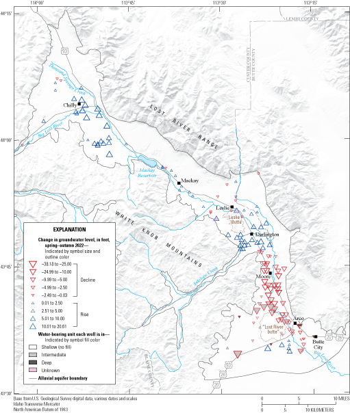
Change in groundwater elevation from spring 2022 to autumn 2022 in the Big Lost River Valley, south-central Idaho (Ducar and Zinsser, 2023; Idaho Department of Water Resources, 2023; U.S. Geological Survey, 2023).
In contrast to the variable pattern of rises and declines in 2022, potentiometric-surface altitudes from spring to autumn 1968 rose in most wells, with rises ranging from 0.03 to 14.80 ft (fig. 2). There were declines in four wells near Arco and one near Chilly; the declines ranged from 0.27 to 5.22 ft (fig. 2). Crosthwaite and others (1970) reported that 1966 was one of the driest years on record at the time, 1967 was one of the wettest, and 1968 was normal. The rise in potentiometric-surface altitudes across an irrigation season suggests that down-valley groundwater flow, recharge from river and canal seepage, and applied irrigation were generally sufficient to recover groundwater-level declines from pumping in 1968. The groundwater-level rise across the 1968 irrigation season is broadly consistent with a pattern of stable to slightly increasing groundwater levels identified from 1950 to 1977 (Sukow, 2017).
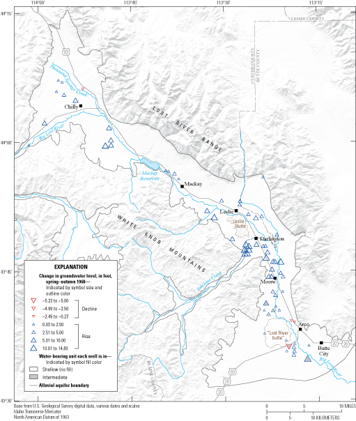
Change in groundwater elevation from spring 1968 to autumn 1968 in the Big Lost River Valley, south-central Idaho (Ducar and Zinsser, 2023; Idaho Department of Water Resources, 2023; U.S. Geological Survey, 2023).
Potentiometric-surface altitudes declined at all wells from spring 1968 to spring 2022 except at the well closest to the outlet of Mackay Reservoir (USGS well 435646113393201), which is influenced by reservoir levels (fig. 3). Potentiometric-surface altitudes declined from 0.93 to 77.52 ft in the shallow and intermediate units. No wells in the deep unit were measured in both spring 1968 and spring 2022. Potentiometric-surface altitudes also declined at most wells from spring 1991 to spring 2022 (fig. 4). Potentiometric-surface altitudes declined 0.35 to 53.99 ft, except in three wells near Arco, where potentiometric-surface altitudes rose between 2.04 and 3.91. Potentiometric-surface altitudes also rose 8.13 ft from spring 1991 to spring 2022 in USGS well 435557113234401, located high on an alluvial fan near Pass Creek.
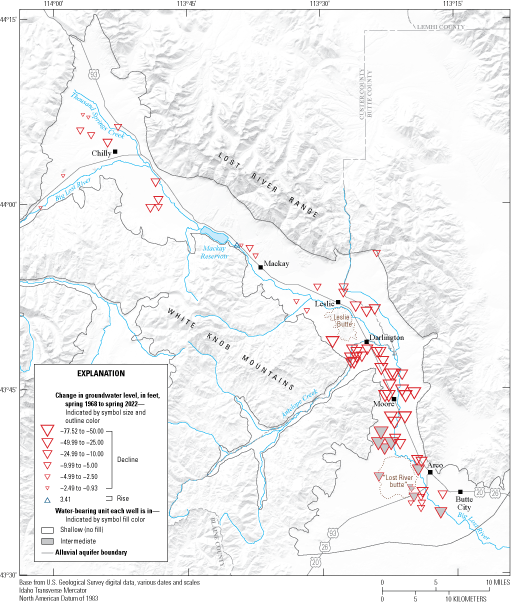
Change in groundwater elevation from spring 1968 to spring 2022 in the Big Lost River Valley, south-central Idaho (Ducar and Zinsser, 2023; Idaho Department of Water Resources, 2023; U.S. Geological Survey, 2023).
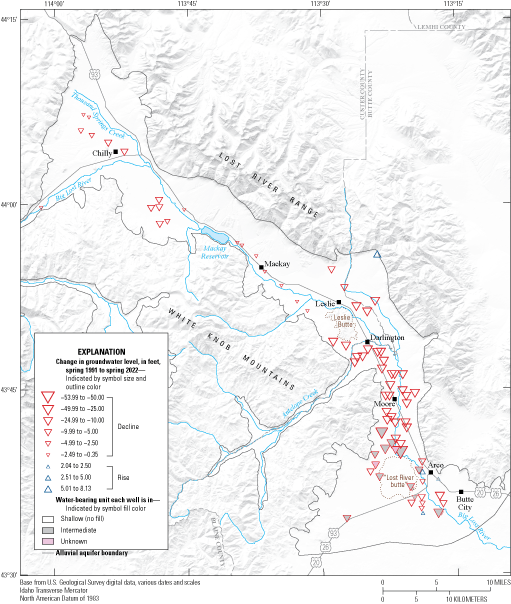
Change in groundwater elevation from spring 1991 to spring 2022 in the Big Lost River Valley, south-central Idaho (Ducar and Zinsser, 2023; Idaho Department of Water Resources, 2023; U.S. Geological Survey, 2023).
From 1950 to 1980, the hydrographs of four long-term groundwater-level monitoring wells from Chilly to Arco showed short periods of groundwater-level declines followed by recovery of groundwater levels within a few years (fig. 5A). In contrast, after 1980, the hydrographs showed longer periods and greater magnitudes of groundwater-level decline, and the variations in groundwater level were larger in the wells near Moore and Arco than in the wells near Leslie and Chilly. These periods of rising and declining groundwater levels were associated with periods with and without flow, respectively, in the Big Lost River near Arco (USGS streamgage 13132500; fig. 5B). The Big Lost River is a heavily managed system with a reservoir and multiple major diversions upstream from the streamgage at Arco; streamflow only reaches the streamgage during years with abundant water supply, with less flow reaching the streamgage after 1980 (fig. 5B). Groundwater-level declines between groundwater synoptic events from 1968, 1991, and 2022 (figs. 1–4) are consistent with longer-term declines (fig. 5B), but also indicate the sensitivity of the change maps to the timing of synoptic events. For example, a synoptic event in 2017 likely would have demonstrated smaller declines in groundwater levels relative to 1968 and rises relative to 1991. Nonetheless, patterns of recharge and withdrawals have changed since 1968, including basin-wide and localized changes in groundwater pumping, applied irrigation (from efficiency improvements), river and canal seepage, and down-valley groundwater flow (for example, Johnson and others, 1991; Sukow, 2017; Clark, 2022). Thus, long-term groundwater-level declines in some parts of the valley indicate that the drawdown in groundwater level that accompanies pumping is no longer fully offset by recharge and down-valley groundwater flow.
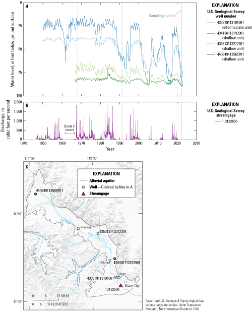
Groundwater levels and streamflow at U.S. Geological Survey (USGS) sites in the Big Lost River Valley, south-central Idaho, 1940−2022. A, groundwater-levels at USGS wells, B, streamflow at Big Lost River near Arco, Idaho, and C, locations of USGS sites in the Big Lost River Valley, south-central Idaho (Idaho Department of Water Resources, 2023; U.S. Geological Survey, 2023).
Summary
Potentiometric-surface maps for spring 2022 and autumn 2022 were created for the alluvial aquifer in the Big Lost River Valley in south-central Idaho using groundwater-level data from 180 wells. Groundwater levels were measured by the U.S. Geological Survey and the Idaho Department of Water Resources between April 4 to 8, 2022, and October 30 to November 4, 2022. Wells previously measured in synoptic events during 1968 and 1991 were preferentially selected to calculate groundwater-level change for each well. Wells were assigned to shallow, intermediate, and deep water-bearing units based on well depth, groundwater potentiometric-surface altitude, and hydrogeologic unit. Potentiometric-surface contours were created for each of the three water-bearing units for spring 2022 and autumn 2022. Groundwater flow generally followed topography down valley to the south. Groundwater levels declined at most wells from spring 1968 to spring 2022 and from spring 1991 to spring 2022. Groundwater level change after an irrigation season was analyzed for 1968 and 2022. In 1968, groundwater levels rose at most wells after an irrigation season. In contrast, during 2022, groundwater levels after an irrigation season rose north of Mackay Reservoir, south and east of Leslie Butte, and south of Lost River butte, but declined in most of the valley south of Antelope Creek. This contrast suggests that recharge and down-valley groundwater flows were insufficient to fully recover groundwater levels across the 2022 irrigation season in some parts of the valley. Groundwater-level changes are sensitive to interannual wet and dry periods, but overall show long-term declines.
References Cited
Ackerman, D.J., Rousseau, J.P., Rattray, G.W., and Fisher, J.C., 2010, Steady-state and transient models of groundwater flow and advective transport, Eastern Snake River Plain aquifer, Idaho National Laboratory and vicinity, Idaho: U.S. Geological Survey Scientific Investigations Report 2010–5123, 220 p., accessed April 10, 2023, at https://doi.org/10.3133/sir20105123.
Bassick, M.D., and Jones, M.L., 1992, Aquifer-test results, direction of ground-water flow, and 1984–90 annual ground-water pumpage for irrigation, lower Big Lost River Valley, Idaho: U.S. Geological Survey Water-Resources Investigations Report 92–4006, 1 pl., scale 1:100,000, accessed January 9, 2023, at https://doi.org/10.3133/wri924006.
Clark, A., 2022, Groundwater budgets for the Big Lost River Basin, south-central Idaho, 2000–19, chap. C of Zinsser, L.M., ed., Characterization of water resources in the Big Lost River Basin, south-central Idaho: U.S. Geological Survey Scientific Investigations Report 2021–5078–C, 111 p., accessed June 9, 2023, at https://doi.org/10.3133/sir20215078C.
Crosthwaite, E.G., Thomas, C.A., and Dyer, K.L., 1970, Water resources in the Big Lost River Basin, south-central Idaho: U.S. Geological Survey Open-File Report 70–93, 122 p., accessed January 9, 2023, at https://doi.org/10.3133/ofr7093.
Cunningham, W.L., and Schalk, C.W., comps. 2011, Groundwater technical procedures of the U.S. Geological Survey: U.S. Geological Survey Techniques and Methods, book 1, chap. A1, 151 p., at https://pubs.usgs.gov/tm/1a1/.
Ducar, S.D., and Zinsser, L.M., 2023, Groundwater potentiometric-surface contours and well numbers used to map groundwater potentiometric-surface altitude in 2022 and groundwater-level changes between 1968, 1991, and 2022 in the alluvial aquifer in the Big Lost River Valley, south-central Idaho: U.S. Geological Survey data release, https://doi.org/10.5066/P93NQAP9.
Dudunake, T.J., and Zinsser, L.M., 2021, Surface-water and groundwater interactions in the Big Lost River, south-central Idaho, chap. B of Zinsser, L.M., ed., Characterization of water resources in the Big Lost River Basin, south-central Idaho: U.S. Geological Survey Scientific Investigations Report 2021–5078–B, 33 p., accessed June 9, 2023, at https://doi.org/10.3133/sir20215078B.
Idaho Department of Water Resources, 2023, Groundwater data portal: Idaho Department of Water Resources database, accessed April 7, 2023, at https://idwr.idaho.gov/water-data/groundwater-levels/.
Johnson, G.S., Ralston, D.R., and Mink, L.L, 1991, Ground-water pumping impacts on surface water irrigation diversions from Big Lost River: Moscow, Idaho, Idaho Water Resources Research Institute, 59 p., accessed September 6, 2023, at https://www.lib.uidaho.edu/digital/iwdl/docs/iwdl-199112.html.
Rydlund Jr, P.H., and Densmore, B.K., 2012, Methods of practice and guidelines for using survey-grade global navigation satellite systems (GNSS) to establish vertical datum in the United States Geological Survey: U.S. Geological Survey Techniques and Methods, book 11, chap. D1, 102 p., accessed March 10, 2023, at https://doi.org/10.3133/tm11D1.
Stearns, H.T., Crandall, L., and Steward, W.G., 1938, Geology and ground-water resources of the Snake River Plain in southeastern Idaho: U.S. Geological Survey Water Supply 774, accessed January 9, 2023, at https://doi.org/10.3133/wsp774.
Sukow, J., 2017, Groundwater in the Big Lost River Valley: Boise, Idaho, Idaho Department of Water Resources memo, 37 p., accessed April 9, 2023, at https://idwr.idaho.gov/wp-content/uploads/sites/2/legal/P-CGWA-2016-001/P-CGWA-2016-001-20170206-IDWR-Staff-Memo-Re-BLRV-by-Jennifer-Sukow.pdf.
U.S. Geological Survey, 2023, National Water Information System—Web interface: U.S. Geological Survey database, accessed April 7, 2023, at https://doi.org/10.5066/F7P55KJN.
Zinsser, L.M., ed., 2021–22, Characterization of water resources in the Big Lost River Basin, south-central Idaho: U.S. Geological Survey Scientific Investigations Report 2021–5078, 3 chap. (A–C), accessed August 26, 2022, at https://doi.org/10.3133/sir20215078.
Zinsser, L.M., 2021, Hydrogeologic framework of the Big Lost River Basin, south-central Idaho, chap. A of Zinsser, L.M., ed., Characterization of water resources in the Big Lost River Basin, south-central Idaho: U.S. Geological Survey Scientific Investigations Report 2021–5078–A, accessed January 9, 2022, at https://doi.org/10.3133/sir20215078A.
Datums
Vertical coordinate information is referenced to the North American Vertical Datum of 1988 (NAVD 88).
Horizontal coordinate information is referenced to the North American Datum of 1983 (NAD 83).
Altitude, as used in this report, refers to distance above the vertical datum.
For information about the research in this report, contact
Director, Idaho Water Science Center
U.S. Geological Survey
230 Collins Road
Boise, Idaho 83702-4520
https://www.usgs.gov/centers/idaho-water-science-center
Manuscript approved on September 3, 2023
Publishing support provided by the U.S. Geological Survey
Science Publishing Network, Tacoma Publishing Service Center
Edited by Nathan A. Severance
Illustration support by Joseph F. Mangano
Layout and graphic design by Yanis X. Castillo
Disclaimers
Any use of trade, firm, or product names is for descriptive purposes only and does not imply endorsement by the U.S. Government.
Although this information product, for the most part, is in the public domain, it also may contain copyrighted materials as noted in the text. Permission to reproduce copyrighted items must be secured from the copyright owner.
Suggested Citation
Ducar, S.D., and Zinsser, L.M., 2023, Groundwater potentiometric-surface altitude in 2022 and groundwater-level changes between 1968, 1991, and 2022, in the alluvial aquifer in the Big Lost River Valley, south-central Idaho: U.S. Geological Survey Scientific Investigations Map 3509, 1 sheet, scale 1:150,000, 11-p. pamphlet, https://doi.org/10.3133/sim3509.
ISSN: 2329-132X (online)
Study Area
| Publication type | Report |
|---|---|
| Publication Subtype | USGS Numbered Series |
| Title | Groundwater potentiometric-surface altitude in 2022 and groundwater-level changes between 1968, 1991, and 2022, in the alluvial aquifer in the Big Lost River Valley, south-central Idaho |
| Series title | Scientific Investigations Map |
| Series number | 3509 |
| DOI | 10.3133/sim3509 |
| Publication Date | September 27, 2023 |
| Year Published | 2023 |
| Language | English |
| Publisher | U.S. Geological Survey |
| Publisher location | Reston, VA |
| Contributing office(s) | Idaho Water Science Center |
| Description | Pamphlet: viii, 11 p.; Map: 22.51 × 30.00 inches |
| Country | United States |
| State | Idaho |
| Other Geospatial | Big Lost River Valley |
| Online Only (Y/N) | Y |
| Additional Online Files (Y/N) | Y |


