

Approximate Inland Extent of Saltwater Intrusion at the Base of the Biscayne Aquifer, Miami-Dade County, Florida, 2022
Links
- Document: Report (2.32 MB pdf) , HTML , XML
- Sheet: Sheet (1.64 MB pdf)
- Data Release: USGS Data Release - Shapefile and summary tables for the approximate inland extent of saltwater intrusion at the base of the Biscayne aquifer in 2022, Miami-Dade County, Florida
- NGMDB Index Page: National Geologic Map Database Index Page
- Download citation as: RIS | Dublin Core
Acknowledgments
The authors would like to acknowledge the organizations that provided data for this study, the Florida Keys Aqueduct Authority, Florida Power & Light Company, and MacVicar Consulting, Inc., as well as Joshua Peele, Lennart Lindahl, and Scott Burns, who provided the data from these organizations.
The authors would also like to acknowledge the work of the many U.S. Geological Survey (USGS) personnel who collected most of the data used for this effort. Without the data provided by these people and organizations, the map in this report could not have been created. Lastly, the authors thank USGS colleagues Yesenia Herrera and Thomas Hyduk for providing helpful comments and suggestions when reviewing this manuscript.
Abstract
Miami-Dade County is part of a densely populated urban corridor in southeastern Florida. The Biscayne aquifer serves as Miami-Dade County’s primary drinking water source and is characterized by highly permeable karstic limestone and carbonate sand. The aquifer’s coastal location and permeable nature make it susceptible to saltwater intrusion. Monitoring the current inland extent and the rate of movement of the saltwater front in the aquifer can inform management strategies for conserving the long-term sustainability of the county’s water supply. In the 1950s, the U.S. Geological Survey published a map of the inland extent of saltwater intrusion in the Biscayne aquifer and has continued to update this map to monitor changes over time, with the most recent update published in 2018. An updated map has been created showing the approximate inland extent of saltwater intrusion in the Biscayne aquifer in eastern Miami-Dade County in 2022, with the 2018 extent shown for comparison. The inland extent of saltwater intrusion was mapped through the interpretation of borehole electromagnetic induction logs and measurements of chloride and specific conductance in groundwater samples. The location of the saltwater interface at the base of the Biscayne aquifer was represented by the 1,000-milligram-per-liter isochlor. This report describes changes in the location of the saltwater interface from 2018 to 2022. By 2022, the saltwater interface had moved farther inland in both the northern and southern parts of the county, advancing by as much as 0.3 kilometer in the north and up to 0.8 kilometer in the Model Land Area to the south. However, it remained relatively unchanged from its 2018 position in the east-central part of the county.
Introduction
Miami-Dade County (formerly “Dade County”) is located along the Atlantic coast in southeastern Florida (fig. 1). The eastern part of the county is a densely populated urban area, which includes the City of Miami, and the western portion of the county extends into Everglades National Park. The topography of southeastern Florida is low-lying, and land surface elevation in the area averages approximately 1.5 meters (m) above mean sea level (U.S. Geological Survey, 2024). The Biscayne aquifer provides 98 percent of the public water supply for south Florida (Prinos and others, 2014) and is the primary drinking-water source for Miami-Dade County, which withdraws around 420 million gallons of fresh groundwater per day (South Florida Water Management District, 2021). Because of the Biscayne aquifer’s proximity to the coast and the low-lying topography of the area, the aquifer is prone to saltwater intrusion.
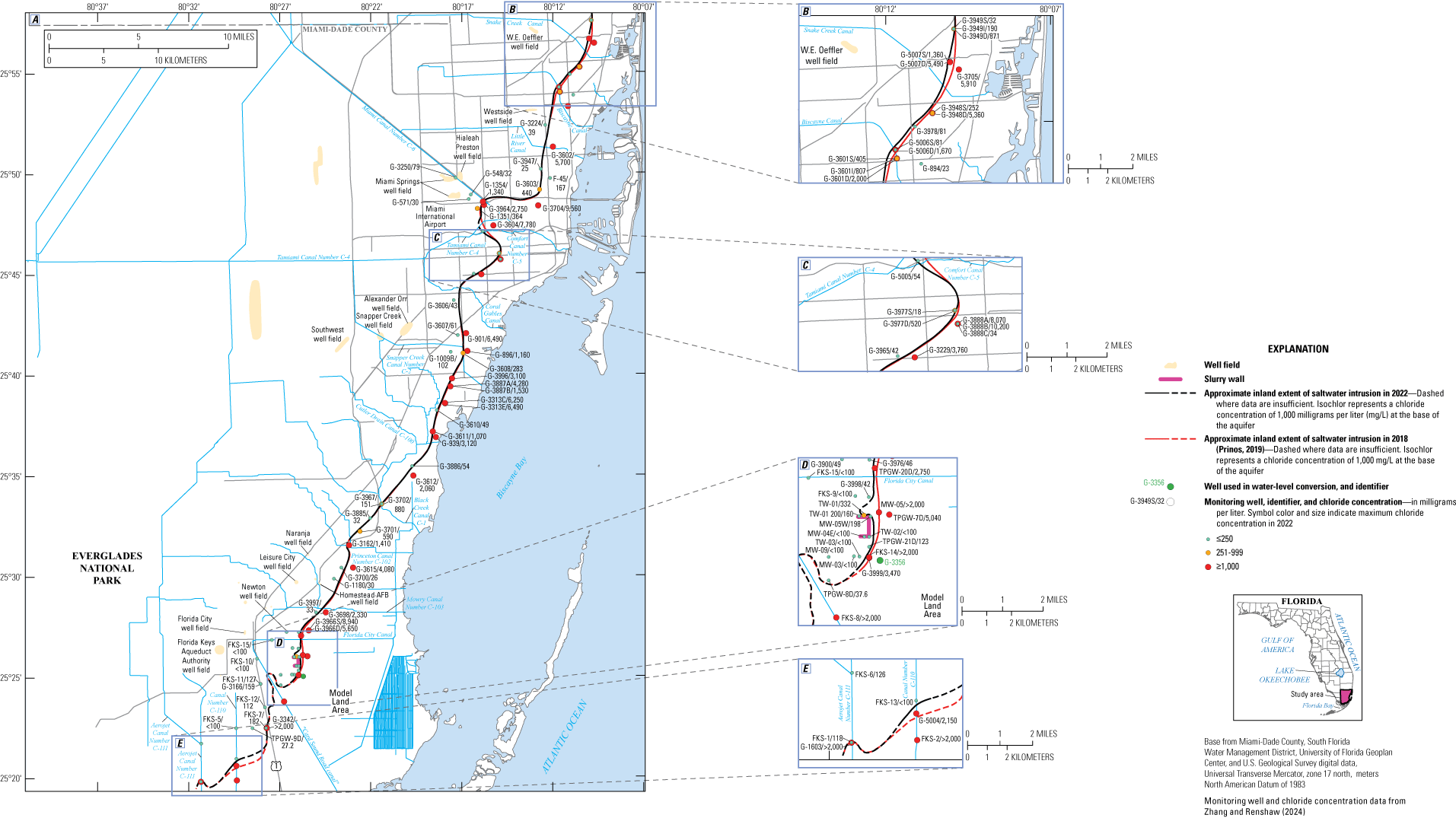
A, The 2022 isochlor map (sheet 1) with insets near, B, the boundary between Miami-Dade and Broward Counties; C, near Miami International Airport and the City of Coral Gables; D, the Model Land area; and E, southern Miami-Dade County.
Because saltwater is denser than freshwater, saltwater typically is present near the base of coastal aquifers with a lens of freshwater above it. The intruding body of saltwater is wedge shaped and thickest near the coast, thinning inland (Renken and others, 2005). The boundary between freshwater and saltwater at the base of this lens is called the freshwater-saltwater interface. In the Biscayne aquifer, chloride concentrations increase across this interface from less than 100 milligrams per liter (mg/L) in the inland part of the aquifer to well over 1,000 mg/L in the seaward part (Prinos, 2019). When the freshwater head above sea level decreases, the depth of the freshwater-saltwater interface becomes shallower. The Ghyben-Herzberg relationship (Ghyben, 1889; Herzberg, 1901) is sometimes used to estimate depth to the saltwater interface. This relationship is based on the ratio of freshwater and saltwater densities and states that for every foot freshwater is above sea level, the saltwater interface is an additional 40 feet (ft) farther below sea level. For example, if the water table is 2 ft above sea level, then the saltwater interface would be about 80 ft below sea level. Because the altitude of the water table is typically higher inland than near the coast, the depth to the top of saltwater interface is deeper inland than near the coast, creating a wedge shape, following the Ghyben-Herzberg relation (Freeze and Cherry, 1979; Prinos and Dixon, 2016); however, this relation was developed to predict the interface position under static conditions. The groundwater in the Biscayne aquifer is dynamic and generally flows along the gradient of the water table toward the ocean, which tends to slow the advance of saltwater intruding inland (Prinos and others, 2014). However, decreases in the freshwater/saltwater head differential or the flow rate toward the ocean can allow saltwater to intrude farther inland.
Declines in the freshwater/saltwater head differential or flow rates can be caused by groundwater withdrawals, droughts, excessive drainage of the aquifer, or by sea-level rise (Barlow, 2003; Basack and others, 2022). Saltwater intrusion into coastal aquifers can also occur via migration of saltwater through coastal canals or by storm surge that inundates the land. When saltwater intrudes into previously fresh areas of the aquifer, water-supply wells that had provided fresh groundwater can begin to produce unpotable saline water (Barlow, 2003; Prinos, 2019).
Chloride concentrations less than 1,000 mg/L are generally required for water to be suitable for human consumption, agricultural irrigation, and industrial uses (Granato and others, 2015). The U.S. Environmental Protection Agency has established a guideline to limit the chloride concentration in drinking water to 250 mg/L or less, because water becomes salty in taste when chloride levels exceed this threshold (U.S. Environmental Protection Agency, 2024). The chloride concentration of saltwater in the ocean is roughly 19,000 mg/L, and thus, even a small influx of saltwater can lead to a notable rise in chloride concentration, making the affected part of the aquifer unsuitable for drinking (Prinos and Valderrama, 2016). The subsequent removal of chloride from water typically requires expensive treatment methods such as ion exchange, reverse osmosis, or distillation (Granato and others, 2015). In this study, the inland extent of saltwater intrusion is depicted by a 1,000-mg/L isochlor at the base of the aquifer.
Saltwater began to intrude the Biscayne aquifer in Miami-Dade County in the early 20th century when canals were excavated to drain part of the Everglades and create agricultural land (Parker and others, 1955). Draining lowered the inland water table, which led to landward advancement of the freshwater-saltwater interface. Between 1950 and 2020, the population of Miami-Dade County increased from approximately 495,000 to 2.7 million people (National Association of Counties, 2022). Saltwater intrusion has continued as water diversions and groundwater withdrawals have increased to support population growth and the associated urban development. In addition to these anthropogenic effects, periodic droughts and extreme storm events have also contributed to saltwater intrusion in the county (Prinos, 2019).
Understanding the extent and rate of advancement of saltwater intrusion in Miami-Dade County can help water managers (1) evaluate the threat of saltwater intrusion to public water supply well fields, (2) design strategies to mitigate and reduce saltwater intrusion, and (3) improve the design of the saltwater intrusion monitoring network. To address this, the U.S. Geological Survey (USGS), in cooperation with Miami-Dade County, initiated the current study to delineate the location of the saltwater interface at the base of the Biscayne aquifer in Miami-Dade County in 2022. The USGS first published the approximate inland extent of the freshwater-saltwater interface in the Biscayne aquifer in Miami-Dade County in 1952 (Hoy, 1952). Parker and others (1955) created a set of maps depicting an estimate of the progression of saltwater encroachment near Miami from 1904 to 1950 and included maps for 1904, 1918, 1943, 1946, and 1950. Subsequent maps depicting the updated location of the freshwater-saltwater interface either across the entire county or in selected areas were created for 1984 (Klein and Waller, 1985), 1995 (Sonenshein, 1997), 2011 (Prinos and others, 2014), 2016 (Prinos, 2017) and 2018 (Prinos, 2019).
Purpose and Scope
The purpose of this report is to document the interpretation of water quality and borehole geophysical data and their integration into a map of the location of the saltwater interface at the base of the Biscayne aquifer in Miami-Dade County in 2022. Water-quality data, including chloride concentrations and specific conductance of water samples from monitoring wells, specific conductance profiles in long-open interval monitoring wells, and time-series electromagnetic induction log (TSEMIL) datasets, were obtained from existing data sources. These data were evaluated and entered into geographic information system (GIS) software to construct a map of the inland extent of saltwater intrusion in the Biscayne aquifer in 2022. Changes in the location of the freshwater/saltwater interface at the base of the aquifer from 2018, when the interface was last mapped, to 2022 are described. Potential improvements to the saltwater intrusion monitoring network and strategies are also discussed.
Hydrogeologic Framework of the Study Area
There are two primary aquifer systems in Miami-Dade County, the surficial aquifer system and the Floridan aquifer system. The Biscayne aquifer is part of the surficial aquifer system, covers approximately 10,400 square kilometers, and underlies parts of Palm Beach, Broward, Miami-Dade, and Monroe Counties (Miller, 1990; Renken and others, 2005; Williams and Dixon, 2015; Williams and Kuniansky, 2015). The Biscayne aquifer is wedge shaped and is thickest toward its eastern extent near the coast (approximately 120 m), thinning out toward its inland extent in the west. Fish and Stewart (1991, p. 15–16) defined the Biscayne aquifer as
. . . that part of the surficial aquifer system in southeastern Florida composed of (from land surface downward) the [Pamlico Sand of Parker and Cooke (1944)], [Miami Limestone], Anastasia Formation, Key Largo Limestone, and Fort Thompson Formation . . . and contiguous, highly permeable beds of the Tamiami Formation . . . where at least 10 ft of the section is very highly permeable (a horizontal hydraulic conductivity of about 1,000 ft/d or more).
The surficial aquifer system is separated from the Floridan aquifer system by a thick sequence of clay, silt, limestone, and fine sand, known as the intermediate confining unit. Most of the intermediate confining unit is composed of the Miocene-Pliocene Hawthorn Group, but in some local areas, it includes parts of the Pliocene Tamiami Formation (Riggs, 1979; Fish and Stewart, 1991; Renken and others, 2005). The Floridan aquifer system covers approximately 260,000 square kilometers of the southeastern United States and extends to a depth of about 1,200 m below land surface in southeastern Florida (Williams and Dixon, 2015; Williams and Kuniansky, 2015).
Mapping the Approximate Inland Extent of Saltwater Intrusion at the Base of the Biscayne Aquifer
Data Compilation and Processing
The location of the saltwater front at the base of the Biscayne aquifer was mapped as the 1,000-mg/L isochlor (sheet 1). To construct the map showing the location of the freshwater-saltwater interface in the Biscayne aquifer in Miami-Dade County in 2022, well construction information, chloride concentrations, and (or) specific conductance measurements were compiled. These data were collected by the USGS, Florida Power & Light (FPL), the Florida Keys Aqueduct Authority (FKAA), and MacVicar Consulting, Inc. (referred to as “MacVicar” herein where company wells are discussed) and have been published by Zhang and Renshaw (2024). One-hundred and six wells were selected on the basis of their proximity to the previously mapped position of the saltwater interface. The sampling, analysis, and quality-assurance procedures for the water-quality data varied depending on which agency collected the data. Summaries of each agency’s procedures can be found in Prinos (2019).
Seventy-six of the wells used for this mapping effort are sampled by the USGS as a part of Miami-Dade County’s saltwater intrusion monitoring program. The frequency of data collection in these wells varies from site to site and includes monthly, quarterly, or semiannual sample collection, specific conductance measurement, and chloride analysis. Data from samples collected between January 1, 2022, and December 31, 2022, were downloaded from the USGS National Water Information System (NWIS) (U.S. Geological Survey, 2023b) using an R-script (R Core Team, 2022) that automatically selected the maximum chloride concentration for each site during this period. Well construction and location information for all the USGS monitoring sites were also obtained from the USGS NWIS database (U.S. Geological Survey, 2023b). Well construction information is reported as depth below land surface in the NWIS database. These depths were converted to altitude using the land surface altitude, referenced to the National Geodetic Vertical Datum of 1929 (NGVD 29), that was also retrieved from the NWIS database.
The remaining 30 wells used for this project are monitored by the FPL, FKAA, and MacVicar Consulting, Inc., and are located in southeastern Miami-Dade County. Well construction information and chloride concentrations from FPL’s quarterly groundwater quality monitoring program were obtained from their 2022 (June 2021–May 2022) and 2023 (June 2022–May 2023) annual monitoring reports (Florida Power & Light, 2022, 2023). The five FPL wells located nearest to the 2018 maximum inland extent of saltwater intrusion (Prinos, 2019) were included in this analysis. Most of FPL’s other monitoring wells are located closer to the coast near the Turkey Point Nuclear Power Plant cooling canal system, which is hypersaline. Well construction depths in the FPL monitoring reports were measured from top of casing (TOC), with altitude referenced to the North American Vertical Datum of 1988 (NAVD 88). Altitudes for the top and bottom of the screen and bottom of the well are also referenced to NAVD 88. These NAVD 88 values were converted to NGVD 29 values using the software program Corpscon (U.S. Army Corps of Engineers, 2024). The maximum chloride concentration measured in water samples collected from each of the five FPL wells during 2022 was selected to help determine the location of the 1,000-mg/L isochlor (table 5 in Zhang and Renshaw, 2024).
The 2022 saltwater intrusion monitoring data were requested from the FKAA. The FKAA monitors 16 wells for saltwater intrusion and collects a single sample for specific conductance measurement and chloride analysis from 3 of these wells on a monthly basis (G-1603, G-3166, and G-3342) (table 4 in Zhang and Renshaw, 2024). The maximum 2022 chloride concentration in each of these 3 wells was used for this mapping effort. The other 13 FKAA wells have long open intervals. The FKAA collects monthly depth profiles of specific conductance in these wells by lowering a water-quality probe through the open portion of the borehole and taking a specific conductance measurement at 1.5-m intervals. The FKAA also collects monthly samples for depth profiles of chloride concentration from these long-open-interval wells by pumping from sample tubes at 1.5-m depth intervals. Because of concerns about possible mixing caused by pumping-induced vertical flow during sampling, data from these chloride profiles were not used for this mapping effort. Instead, for these 13 sites, chloride concentrations were estimated from the maximum 2022 specific conductance reading at the profile location closest to base of the Biscayne aquifer in each well (table 4 in Zhang and Renshaw, 2024). The linear regression model used to estimate chloride concentrations from specific conductance is described below. The depths for the specific conductance profiles collected by the FKAA were measured from the TOC of the monitoring well. The altitudes of the specific conductance profile sample locations were determined using the altitude of the TOC, referenced to NGVD 29.
Saltwater intrusion monitoring data for 2022 collected by MacVicar Consulting Inc. were obtained from their quarterly monitoring reports (MacVicar Consulting, Inc., 2022a, c), which include depth profiles of specific conductance in nine long-open-interval monitoring wells. Although they measured the depths for the profiles from the water surface, their reports do not reference the water level to a national vertical datum. Therefore, water-level data from a nearby USGS site, G-3356 (sheet 1 and fig. 1D), referenced to NGVD 29, were used to approximate the altitudes of the water-level at the MacVicar wells. To determine which profile location was closest to the base of the Biscayne aquifer in each of the MacVicar wells, the profile depths and depth to the base of the Biscayne aquifer were both converted to depth below TOC. Equation 1 was used to calculate the depth of the base of the Biscayne aquifer below the TOC:
whereBBtc
is the estimated depth of the bottom of the Biscayne aquifer below top of casing, in meters;
BBalt
is the altitude of the base of the Biscayne aquifer, in meters NGVD 29, estimated from Fish and Stewart (1991);
WLalt
is the altitude of the water level in G-3356, in meters NGVD 29 on the day of sampling; and
DTW
is the depth to water below top of casing in the MacVicar well measured at the time of sampling, in meters.
The maximum 2022 specific conductance measurements from the sample depth closest to the base of the Biscayne aquifer were used to estimate the maximum chloride concentration in each MacVicar well (table 3 in Zhang and Renshaw, 2024).
Estimating Chloride Concentration From Specific Conductance
To estimate chloride concentrations from the specific conductance measurements collected by FKAA and MacVicar Consulting, Inc., a linear regression model was developed from chloride and specific conductance data from USGS monitoring wells. Several previous studies have evaluated the relation between chloride and specific conductance in the Biscayne aquifer (Fitterman and Prinos, 2011; Fitterman, 2014; Prinos, 2017; MacVicar Consulting, Inc., 2022a, b, c). For the previous USGS update of the inland extent of saltwater intrusion in the Biscayne aquifer, a linear regression between chloride and specific conductance was created by using data from 249 water samples with chloride concentrations less than 2,000 mg/L. These samples were collected by the USGS from seven monitoring wells in the southeastern part of Miami-Dade County between October 26, 1999, and July 23, 2018 (Prinos, 2019). This previous regression, shown in equation 2, resulted in a coefficient of determination (R2) of 0.9667 and yielded the following relation between chloride and specific conductance (Prinos, 2019):
wherecc
is the predicted chloride concentration in milligrams per liter; and
sc
is the measured specific conductance, in microsiemens per centimeter at 25 degrees Celsius (µS/cm at 25 °C).
Figure 2A shows the same data used for the Prinos (2019) regression, with the addition of data from more recent samples that were collected between July 24, 2018, and July 12, 2022, and a line fit through the data with linear regression. Figure 2B provides a closer view of these data and the linear fit at the low end of the plot (specific conductance less than 1,000 µS/cm and chloride concentration greater than 200 mg/L). Samples with specific conductance values below 728 µS/cm or chloride concentrations below 100 mg/L deviate from the regression line. Therefore, instead of only limiting chloride concentrations to below 2,000 mg/L, as in Prinos (2019), this report narrows the chloride concentrations in samples used for the regression analysis to between 100 and 2,000 mg/L. The resulting dataset for the regression analysis included chloride and specific conductance data from 58 water samples collected from four USGS monitoring wells (fig. 3; table 2 in Zhang and Renshaw, 2024) between July 2010 and July 2020. Equation 3 and figure 3 show the resulting relationship between chloride concentration and specific conductance:
The R2 value for this relationship is 0.992.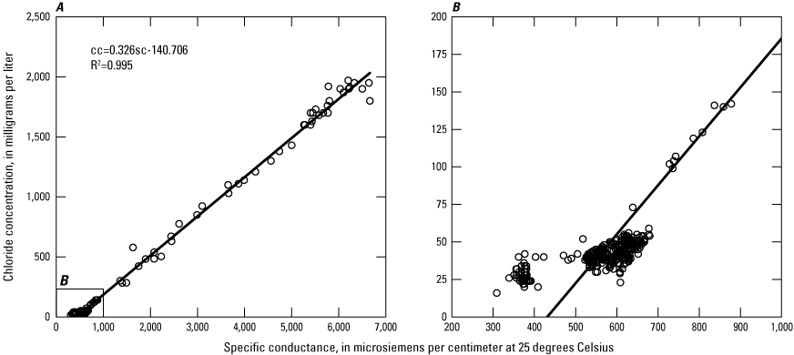
A, Chloride and specific conductance data collected between October 26, 1999, and July 12, 2022, from the seven wells that were used for the Prinos (2019) regression with a best-fit line through those data. B, Inset showing the data and line shown in panel A, focusing on the lower left corner of the plot where the specific conductance is less than 1,000 microsiemens per centimeter at 25 degrees Celsius and the chloride concentration is less than 200 milligrams per liter. cc, chloride concentration; sc, specific conductance.
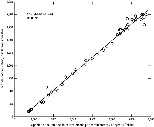
Linear regression between chloride concentration and specific conductance updated for this study. cc, chloride concentration; sc, specific conductance.
The maximum 2022 specific conductance measurements collected from the profile locations closest to the base of the Biscayne aquifer in the FKAA and MacVicar wells were used to estimate chloride concentrations. To avoid extrapolating the regression equation beyond the limits of the data, estimated chloride values less than 100 mg/L or greater than 2,000 mg/L were designated as <100 and >2,000, respectively. The estimated chloride concentrations are shown in tables 3 and 4 in Zhang and Renshaw (2024).
Potential Permeable Layers Below the Mapped Base of the Biscayne Aquifer
Fish and Stewart (1991) constructed a structure contour map of the base of the Biscayne aquifer on the basis of data (aquifer tests and vertical hydraulic conductivity profiles) from approximately 40 test wells throughout southeastern Florida. For all non-USGS wells used to map the saltwater front for this report, the altitude of the base of the Biscayne aquifer was assumed to be the same as that estimated by Fish and Stewart (1991). In some locations, however, borehole geophysical data collected in relatively new USGS monitoring wells indicate that saltwater is readily intruding below the base of the Biscayne aquifer as estimated by Fish and Stewart (1991), particularly in northeastern Miami-Dade County.
It is important to correctly identify the base of the Biscayne aquifer, because a fresh chloride measurement taken from a shallower depth could lead to the misinterpretation of the position of the saltwater interface. In some areas, the base of the Biscayne aquifer is difficult to identify because of interfingering sands and calcareous sediments, and data were only available from four test holes in northeastern Miami-Dade County when Fish and Stewart (1991) created their map. The fact that saltwater is readily intruding below the base of the Biscayne aquifer as estimated by Fish and Stewart (1991) indicates the presence of permeable beds in the upper Tamiami Formation that were not apparent in the data available to the authors of that report. It is beyond the scope of this report to re-evaluate the location of the base of the Biscayne aquifer. However, at wells where borehole geophysical data indicate saltwater intrusion is present below the mapped basal surface of the aquifer, for the purposes of this report, it is assumed that there is a permeable zone in the Tamiami Formation in these locations that is hydraulically connected to the Biscayne aquifer. More discussion on this can be found in the “Changes in the Location of the Saltwater Interface Between 2018 and 2022” section of this report.
Map and Isochlor Position
All of the measured and estimated chloride concentration data, well location, and well construction information were imported into ArcGIS Pro (Esri, Redlands, California) to create the map and isochlor (sheet 1). The location of the 1,000-mg/L isochlor was estimated and mapped by using the maximum measured or estimated chloride concentrations from each well for 2022. In some locations, bulk conductivity data from TSEMILs were used to help interpret the inland extent of saltwater intrusion.
Prinos and Valderrama (2016) determined that a bulk conductivity of about 70 millisiemens per meter (mS/m) represents the threshold between brackish and saline water in the Biscayne aquifer. Therefore, for this report, saltwater was assumed to be present where bulk conductivity from electromagnetic induction logs was greater than around 70 mS/m. The resulting isochlor represents the approximate maximum inland extent of saltwater intrusion at the base of the Biscayne aquifer.
Changes in the Location of the Saltwater Interface Between 2018 and 2022
In 2022, the saltwater interface at the base of the Biscayne aquifer was mapped farther inland than it was in 2018 near the Broward and Miami-Dade County line (fig. 1B), as well as in the Model Land Area (fig. 1D). Between the Tamiami Canal Number C-4 and Princeton Canal Number C-102, however, the interface remained relatively unchanged from its 2018 position. In some instances, inland advances are indicated by increases in chloride concentrations and bulk conductivities that have been measured through time, but in others the changes in the position of the 1,000-mg/L isochlor are the result of added monitoring wells where coverage had previously been insufficient. These changes are discussed in greater detail below, starting with the sites located in northern Miami-Dade County and working southward.
Northern Miami-Dade County
G-3949 Well Cluster
In northernmost Miami-Dade County, the 1,000-mg/L isochlor was interpreted as having advanced inland 0.1 kilometer (km) near the G-3949 well cluster since 2018 (sheet 1 and fig. 1B) but had not yet crossed the cluster. The deep well in this cluster, G-3949D, is screened from −62 to −64 m NGVD 29 (fig. 4), and between 2018 and 2022, the maximum chloride concentration of water samples from this well increased from 247 to 871 mg/L (Prinos, 2019; Zhang and Renshaw, 2024).
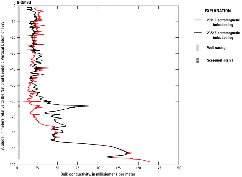
Electromagnetic induction logs collected from well G-3949D in 2011 and 2022 (U.S. Geological Survey, 2023a).
Fish and Stewart (1991) estimated the base of the Biscayne aquifer in this area to be around −45 m NGVD 29, and core descriptions from G-3949D indicate that the top of the Tamiami Formation is approximately −31 m NGVD 29. However, the core descriptions also indicate that the rock is generally highly or moderately porous from −1 to −80 m NGVD 29 (Prinos and others, 2014), and bulk conductivity from TSEMIL logs has been increasing in this well in a zone that is between about −55 and −80 m NGVD 29 since 2011 (fig. 4 and table 1). Therefore, for the purposes of interpreting the location of the salt front, it is assumed that, at this location, a permeable zone is present below the base of the Biscayne aquifer, as estimated by Fish and Stewart (1991). The maximum bulk conductivity in this zone in 2022 was 88 mS/m at −62 m NGVD 29. Therefore, both the chloride concentrations and the increase in bulk conductivity indicate that the interface was very close to this well cluster in 2022 and is readily intruding this area.
Table 1.
Electromagnetic induction log plots and data for U.S. Geological Survey (USGS) monitoring wells.[Hyperlinks open to USGS GeoLog locator (U.S. Geological Survey, 2023a). (Wells G-5007D and G-5006D have well names G-5007 and G-5006 in data files, respectively.) ID, identifier; TSEMIL, time-series electromagnetic induction log]
| USGS site number | USGS site name | Clickable hyperlink to access TSEMIL plot or data |
|---|---|---|
| 255733080195601 |
G-3949D |
Plot Data |
| 255639080100401 | G-5007D | Plot Data |
| 255453080110801 |
G-3978 | Plot Data |
| 255415080114401 |
G-5006D | Plot Data |
| 254707080155801 |
G-5005 | Plot Data |
| 254601080150301 |
G-3977D | Plot Data |
| 252714080260901 |
G-3976 | Plot Data |
| 252506080261001 |
G-3999 | Plot Data |
| 252036080293501 |
G-5004 | Plot Data |
G-5007 Well Cluster
Between the Broward and Miami-Dade County line and the Snake Creek Canal, the 1,000-mg/L isochlor for 2022 was mapped as much as 0.34 km inland of where it was mapped in 2018. This interpretation is primarily based on data from the new G-5007 monitoring well cluster (fig. 1B, sheet 1) installed in 2019 and first sampled in April 2020. The screened interval in G-5007D is below the base of the Biscayne aquifer as estimated by Fish and Stewart (1991), and the screened interval in G-5007S is above the base. The initial water samples from 2020 had chloride concentrations of 4,440 and 1,030 mg/L for G-5007D and G-5007S, respectively (U.S. Geological Survey, 2023b), and the maximum chloride concentrations in 2022 increased to 5,490 and 1,360 mg/L in the deep and shallow well, respectively (table 1 in Zhang and Renshaw, 2024). Fish and Stewart (1991) estimated the base of the Biscayne aquifer in this area to be around −46 m NGVD 29, and the TSEMIL data indicate that saltwater is readily intruding the rock from about −30 to −73 m NGVD 29 with a maximum 2022 bulk conductivity well above 70 mS/m (table 1). Therefore, the saltwater interface has already passed this location.
G-3978
At well G-3978 (fig. 1B), which is about 1.5 km north of the Biscayne Canal, the 1,000-mg/L isochlor for 2022 was mapped 0.15 km farther inland than it was in 2018. Although the maximum chloride concentration of water samples collected from well G-3978 increased from only 69 mg/L in 2018 (Prinos and others, 2014) to a maximum of 81 mg/L in 2022 (table 1 in Zhang and Renshaw, 2024), the bottom of the open interval of this well is 9.4 m above the base of the Biscayne aquifer estimated from Fish and Stewart (1991), which is −49 m NGVD 29. The TSEMIL dataset from G-3978 indicated that saltwater has readily intruded the rocks and sediments at this location from 2018 to 2022 at altitudes between about −43 and −80 m NGVD 29 (fig. 5 and table 1), which indicates that there is a permeable zone beneath the basal surface of the Biscayne aquifer estimated by Fish and Stewart (1991). Specifically, the maximum bulk conductivity in the 2022 TSEMIL log was 192 mS/m at −77 m NGVD 29. Therefore, the 1,000-mg/L isochlor was mapped inland of this well, and the interface is shown as having advanced in this area since 2018.
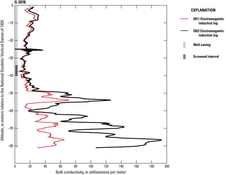
Electromagnetic induction logs collected from well G-3978 in 2011 and 2022 (U.S. Geological Survey, 2023a).
G-5006 Well Cluster
At the G-5006 well cluster (fig. 1B and sheet 1), the 1,000-mg/L isochlor for 2022 was mapped to be 0.3 km farther inland along the Biscayne Canal than it was in 2018. This well cluster (fig. 1B and sheet 1) was installed in 2019 next to the Biscayne Canal. The bottom of the open intervals in G-5006S and G-5006D is approximately 28 m above and 8 m below, respectively, the base of the Biscayne aquifer estimated from Fish and Stewart (1991) at this location. The first water samples were collected from these wells on April 22, 2020, and the chloride concentrations were 63 mg/L in G-5006S and 1,360 mg/L in G-5006D (U.S. Geological Survey, 2023b). In 2022, the maximum chloride concentrations reached 81 mg/L in G-5006S and 1,670 mg/L in G-5006D (table 1 in Zhang and Renshaw, 2024). Chloride concentrations gradually increased in quarterly samples in both of these wells between 2020 and 2022. Fish and Stewart (1991) estimated the base of the Biscayne aquifer at this location to be at −50 m NGVD 29. Bulk conductivity of the 2022 log reached about 85 mS/m at −55 m NGVD 29. The bulk conductivity from the TSEMIL data as well as the increasing chloride concentrations of water samples from G-5006D both indicated that saltwater was actively intruding at this location and the 1,000-mg/L isochlor was mapped as having passed this well.
Near Miami International Airport and the City of Coral Gables
G-5005
Near the Comfort Canal Number C-5, close to where it feeds into the Tamiami Canal Number C-4, the 1,000-mg/L isochlor for 2022 was about 0.4 km inland of where it was mapped in 2018 (fig. 1C, sheet 1). This interpretation is based on the data from a new monitoring well, G-5005, installed in October 2019 and first sampled in April 2022 (Zhang and Renshaw, 2024). The maximum chloride concentration of water samples collected in 2022 was 54 mg/L. However, the bottom of the open interval for this well is 7.4 m above the altitude of the base of the Biscayne aquifer estimated from Fish and Stewart (1991), which is −35.7 m NGVD 29. The TSEMIL dataset collected from well G-5005 (U.S. Geological Survey, 2023a) indicated that saltwater is intruding from −31 to −54 m NGVD 29, which indicates that there is a permeable zone beneath the basal surface of the Biscayne aquifer estimated by Fish and Stewart (1991). In 2022, bulk conductivity reached 200 mS/m between −43 and −47 m NGVD 29 (fig. 6). Therefore, the 1,000-mg/L isochlor was mapped inland of this location.
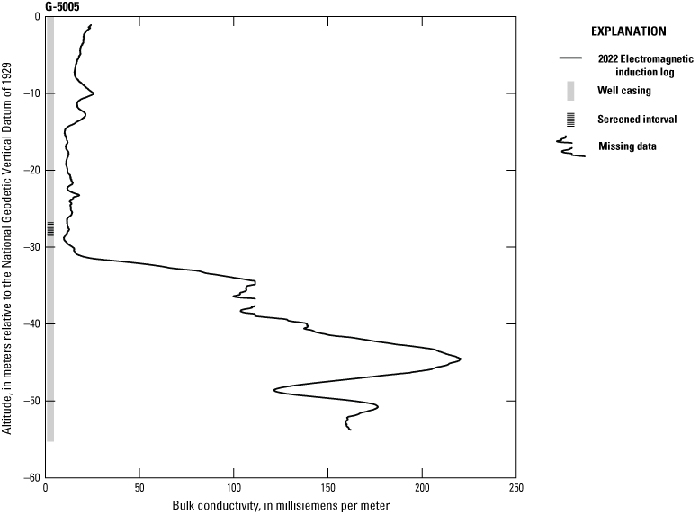
Electromagnetic induction log collected from well G-5005 in 2022.
G-3977 Well Cluster
In the area south of the Comfort Canal Number C-5, the 1,000-mg/L isochlor for 2022 was mapped between monitoring well clusters G-3977 and G-3888 (fig. 1C). Since it was first sampled in 2016, the chloride concentration of water samples collected from the deep well, G-3977D, continually increased. G-3977D is screened about 3 m above the altitude at which Fish and Stewart (1991) estimated the base of the Biscayne aquifer. The maximum chloride concentration sampled from well G-3977D in 2022 was 520 mg/L, which is brackish but not yet over the threshold for saline water. The bulk conductivity did not exceed the 70-mS/m brackish/saline threshold at any depth. Therefore, in 2022 the 1,000-mg/L isochlor was approaching this location but had not passed this well.
Model Land Area
TPGW-20D and G-3976
North of the Florida City Canal (sheet 1 and fig. 1D), the 1,000-mg/L isochlor for 2022 was mapped as much as 0.17 km farther inland than it was in 2018 (fig. 1D). The open interval of TPGW-20D is between −23 and −24 m NGVD 29, which is about 2 m above the base of the Biscayne aquifer estimated from Fish and Stewart (1991). The TSEMIL dataset for this well indicates saltwater is intruding from −22 to −28 m NGVD 29, and the maximum bulk conductivity from this depth interval increased from 43 mS/m in 2018 to 232 mS/m in 2022 (table 1). The maximum chloride concentration of water samples collected from well TPGW-20D during 2022 was 2,720 mg/L. Monitoring well G-3976 is located 0.4 km northeast of TPGW-20 and is also screened a couple of meters above the base of the Biscayne aquifer estimated from Fish and Stewart (1991). In 2022, chloride concentrations at G-3976 remained fresh, with a maximum chloride concentration of 46 mg/L. Therefore, the 1,000-mg/L isochlor for 2022 was mapped inland of well TPGW-20D, and the salt front had not reached well G-3976.
TW-01, MW-05W, and TW-01 200
South of the Florida City Canal in the Model Land Area (fig. 1D and sheet 1), the 1,000-mg/L isochlor for 2022 was mapped as much as 0.8 km inland of where it was in 2018. The line depicting the isochlor in this area was dashed because of uncertainty. The data available for this area are the FKAA specific conductance profiles from wells with long open intervals. The estimated maximum chloride concentration near the base of the Biscayne aquifer in well TW-01 in 2022 was 332 mg/L. Well MW-05W is located 0.3 km to the east of TW-01, and the estimated maximum 2022 chloride concentration near the base of the Biscayne aquifer in this well was 198 mg/L. Well TW-01 200 is located 0.16 km west of well TW-01, and the estimated 2022 maximum chloride concentration near the base of the Biscayne aquifer in this well was 160 mg/L. Given the proximity of the wells to one another, it is unclear why the estimated chloride concentration in well TW-01 would be higher than in the other two wells.
Possible factors contributing to the difference in chloride concentration just described include the construction of a slurry wall in 2019 to prevent encroaching saltwater from entering quarry lakes, which could have caused isolated pockets of saltwater in the aquifer to migrate because of rapid pressure changes during blasting. The blasting also could have produced fine particles, which, because of their large reactive surface area, could have caused an increase in total dissolved solids (Langer, 2001). In addition to the construction of the slurry wall, the natural substantial spatial variability in porosity and permeability of the karstic Biscayne aquifer could result in the saltwater front progressing farther inland near one well than near the others.
FKS-14, G-3999, and TPGW-21D
In the Model Land Area, south of the slurry wall (sheet 1), the 1,000-mg/L isochlor for 2022 was mapped 0.17 km farther inland than it was in 2018. The maximum estimated chloride concentration for FKS-14 (fig. 1D) in 2022 was >2,000 mg/L. This estimated chloride concentration was derived from a specific conductance measurement approximately 3 m above the base of the Biscayne aquifer estimated by Fish and Stewart (1991). The chloride concentration in neighboring USGS monitoring well G-3999, screened 4 m above the base of the Biscayne aquifer as estimated by Fish and Stewart (1991), steadily increased from 302 mg/L in July 2018 to a maximum of 3,470 mg/L in 2022. This indicates that the salt front has advanced inland in this region.
TPGW-21D is located 0.43 km north of G-3999 (fig. 1D and sheet 1), and it had a maximum chloride concentration of 123 mg/L in 2022. The open interval of well TPGW-21D is from −20 to −21 m NGVD 29, which is about 5 m above the estimated base of the Biscayne aquifer (Fish and Stewart, 1991). This well extends below the base of the Biscayne aquifer, and bulk conductivity from the TSEMIL in 2022 remained below 40 mS/m throughout the full well depth, which also indicates that the front did not move past this well. On the basis of data from monitoring wells FKS-14, G-3999, and TPGW-21D, the 1,000-mg/L isochlor was mapped past FKS-14 and G-3999, but the saltwater front had not passed TPGW-21D.
Southern Miami-Dade County
G-5004 and FKS-13
In a location approximately 8–9 km southwest of the intersection of U.S. Highway 1 and Card Sound Road, the 1,000-mg/L isochlor for 2022 was mapped as much as 0.6 km farther inland than in 2018 (sheet 1). This updated position is based on the data from the new well G-5004 (fig. 1E), which is screened about 1.6 m below the estimated base of the Biscayne aquifer (Fish and Stewart, 1991). The first sample was collected from this well in April 2020, and it had a chloride concentration of 1,910 mg/L. The maximum chloride concentration from samples collected from this well in 2022 was 2,150 mg/L. FKS-13 is located approximately 650 m north of G-5004 (fig. 1E). The maximum 2022 chloride concentration in this well was less than 100 mg/L, estimated from a specific conductance measurement approximately 0.4 m below the estimated base of the Biscayne aquifer (Fish and Stewart, 1991). Therefore, the 1,000-mg/L isochlor was mapped between wells G-5004 and FKS-13.
FKS-1 and G-1603
Near the Aerojet Canal Number C-111, the 1,000-mg/L isochlor for 2022 was mapped at the same location as in 2018 (sheet 1) on the basis of data from monitoring wells FKS-1 and G-1603, which are only 9.1 m apart (fig. 1E). In 2022, the maximum chloride concentration in FKS-1 was 118 mg/L, estimated from a specific conductance measurement collected approximately 6.4 m above the base of the Biscayne aquifer. In contrast, the maximum estimated chloride concentration in G-1603, screened about 1.5 m above the base of the Biscayne aquifer, exceeded 2,000 mg/L. Therefore, the 1,000-mg/L isochlor was mapped at the two well locations. However, the line was approximated between the wells at this location and G-5004, to the northeast, because of a lack of monitoring wells to determine the inland extent of the 1,000-mg/L isochlor in this area.
Potential Network Improvements
Miami-Dade County has the densest coverage of active groundwater monitoring wells near the coast in south Florida, as well as a comprehensive monitoring network for saltwater intrusion (Prinos, 2019). However, active monitoring for saltwater intrusion requires frequent additions of new wells, especially on the inland side of the 1,000-mg/L isochlor. In areas with insufficient spatial coverage, the position of the 1,000-mg/L isochlor is interpolated between wells for which there are chloride data. This interpolation contributes to uncertainty. Additionally, inconsistency in monitoring well designs, protocols and data accessibility among the various organizations collecting data also creates uncertainty when interpreting the data. Lastly, it is challenging to differentiate between saltwater intruding along the base of the aquifer from the ocean and saltwater flowing inland up canals and then leaking into the aquifer. In the sections below, these three potential network improvements are discussed.
Improvements in Spatial Coverage
The position of the freshwater-saltwater interface is transient and monitoring wells may lose their relevance as the salt front migrates past them over time. Thus, the addition of new wells inland of the 1,000-mg/L isochlor could improve accuracy in constraining the maximum inland extent of saltwater intrusion in the Biscayne aquifer. Miami-Dade County has been cooperating with the USGS to install new wells to expand the saltwater intrusion monitoring network in the Biscayne aquifer for decades.
While interpreting the data for this report, locations where data gaps remain and where the saltwater front has moved past the existing monitoring well network were noted. On the basis of this information, 14 potential new well locations were identified for Miami-Dade County to consider when expanding its saltwater intrusion monitoring network. New wells at these locations would further fill in the existing gaps in monitoring and constrain the maximum inland extent of saltwater intrusion for future mapping efforts.
Variations in Well Construction
In addition to limited spatial coverage of monitoring wells in some areas, variations in well construction also contribute to uncertainty in interpreting the data. There are a variety of factors to be considered when determining how to construct monitoring wells, including cost and specific objectives of the monitoring program. In this study, monitoring wells constructed to meet different program objectives were used. As a result, these wells were not all constructed in the same way. For instance, some wells have long open intervals, whereas others are screened over shorter intervals. This variation in well construction can affect data quality. For example, pumping to collect samples for saltwater intrusion monitoring in salt contaminated aquifers in long-open-interval wells could lead to vertical mixing (Kohout and Hoy, 1963; Shapiro, 2002; Shalev and others, 2009; Prinos, 2013; Prinos and Valderrama, 2015; Prinos, 2019). There is also a potential for vertical mixing in the borehole in long-open-interval wells because of natural vertical gradients in the aquifer (Church and Granato, 1996; Oki and Presley, 2008). Conductivity profiles from both short-screened and long-screened monitoring wells are used in this study, which could introduce some uncertainty in the data. To reduce uncertainty, short-open-interval wells are recommended for saltwater intrusion monitoring (Church and Granato, 1996). The USGS, in cooperation with Miami-Dade County, has adopted a strategy of installing either individual short-screened wells or nests of short-screened monitoring wells for saltwater intrusion monitoring. Although not ideal, available data from long-open-interval wells remain valuable for filling spatial gaps and mapping the location of the saltwater front.
In addition, some wells currently in the Miami-Dade County saltwater intrusion monitoring network are not deep enough to detect saltwater at the base of the Biscayne aquifer. Examples of such wells are G-3948, G-3949, G-3976, G-3978, G-3999, G-5005, G-5006, and G-5007. In these areas, interpretation of the saltwater interface position was based on chloride values from samples taken well above the base of the Biscayne aquifer, or through electromagnetic induction logs showing clear indications of saltwater presence or absence below a well’s screened interval in the aquifer. Most of the newer monitoring wells installed by Miami-Dade County have been designed to fully penetrate the Biscayne aquifer and extend well below it so that the TSEMIL datasets can indicate any saltwater intruding deeper than the base of the Biscayne aquifer. Using this type of well construction when installing additional monitoring wells could provide more accurate saltwater intrusion monitoring data.
Effects of Canal Leakage
Even though salinity control structures have been installed by the South Florida Water Management District to control drainage, flooding, and saltwater intrusion, saltwater still leaks around the existing salinity control structures and through the porous rock of the Biscayne aquifer (Parker and others, 1955; Kohout and Leach, 1964; Prinos and others, 2014). This saltwater leakage through canals is observed in the occurrence of unusual fluctuations in chloride concentrations in wells near the canals. As described by Prinos and others (2014), chloride concentrations in some wells near canals were observed to rapidly increase for a short period before gradually dissipating over time. This detection of increased chloride concentrations in wells near canals presents challenges in discerning whether such increases originate from the canals or the ocean. As a result, there is a risk of misinterpreting the position of the saltwater interface. This unusual fluctuation in chloride concentrations is observed from wells near canals including the Florida City Canal, a feature known locally and referred to herein as “Card Sound Road canal,” Cutler Drain Canal C-100, Miami Canal, Mowry Canal Number C-103, Princeton Canal Number C-102, Snapper Creek Canal Number C-2, Black Creek Canal C-1, Biscayne Canal, and Comfort Canal Number C-5 (Prinos and others, 2014). Therefore, increasing the frequency in continuous salinity and water-level monitoring near canals could aid in determining the origin of the increased chloride concentration at those locations. Further discussion on the effects of canal leakage on aquifer salinity can be found in Prinos and others (2014).
Summary
The 1,000-milligram-per-liter isochlor map for 2022 illustrates the approximate inland extent of saltwater intrusion in the Biscayne aquifer in eastern Miami-Dade County. This update of the 2018 map was achieved through the interpretation of borehole electromagnetic induction logs and measurements of chloride and specific conductance in groundwater samples. The updated map shows that from 2018 to 2022, the saltwater front advanced farther inland in northern Miami-Dade County and the Model Land Area in the south, but remained relatively unchanged in the east-central region. To improve monitoring, additional wells are planned to continue expanding the saltwater-intrusion network across the county. Lastly, variations in well construction and canal leakage are discussed as potential sources of data uncertainty.
References Cited
Barlow, P.M., 2003, Ground water in freshwater-saltwater environments of the Atlantic Coast: U.S. Geological Survey Circular 1262, 113 p., accessed December 1, 2022, at https://doi.org/10.3133/cir1262.
Basack, S., Loganathan, M.K., Goswami, G., and Khabbaz, H., 2022, Saltwater intrusion into coastal aquifers and associated risk management—Critical review and research directives: Journal of Coastal Research, v. 38, no. 3, p. 654–672, accessed December 1, 2022, at https://doi.org/10.2112/JCOASTRES-D-21-00116.1.
Church, P.E., and Granato, G.E., 1996, Bias in groundwater-water data caused by well-bore flow in long-screen wells: Ground Water, v. 34, no. 2, p. 262–273, accessed November 24, 2023, at https://doi.org/10.1111/j.1745-6584.1996.tb01886.x.
Fish, J.E., and Stewart, M., 1991, Hydrogeology of the surficial aquifer system, Dade County, Florida: U.S. Geological Survey Water-Resources Investigations Report 90–4108, 50 p., 11 sheets, accessed December 31, 2024, at https://doi.org/10.3133/wri904108.
Fitterman, D.V., 2014, Mapping saltwater intrusion in the Biscayne aquifer, Miami-Dade County, Florida using transient electromagnetic sounding: Journal of Environmental & Engineering Geophysics, v. 19, no. 1, p. 33–43, accessed December 31, 2024, at https://doi.org/10.2113/JEEG19.1.33.
Fitterman, D.V., and Prinos, S.T., 2011, Results of time domain electromagnetic soundings in Miami-Dade and southern Broward Counties, Florida: U.S. Geological Survey Open-File Report 2011–1299, 43 p., 7 app., accessed December 31, 2024, at https://pubs.usgs.gov/of/2011/1299/.
Florida Power & Light, 2022, Turkey Point clean energy center—Annual monitoring report: Florida Power and Light, prepared by Stantec, accessed June 20, 2024, at https://prodenv.dep.state.fl.us/DepStaging/api/dms/38.1168669.1.
Florida Power & Light, 2023, Clean energy center—Annual report: Florida Power and Light, accessed June 20, 2024, at https://prodenv.dep.state.fl.us/DepStaging/api/dms/38.1221669.1.
Granato, G.E., DeSimone, L.A., Barbaro, J.R., and Jeznach, L.C., 2015, Methods of evaluating potential sources of chloride in surface waters and groundwater of the conterminous United States: U.S. Geological Survey Open-File Report 2015–1080, 89 p., accessed November 9, 2022, at https://doi.org/10.3133/ofr20151080.
Hoy, N.D., 1952, Two maps of Dade County, Florida, showing approximate position of the 1000-ppm isochlor as of 1951 and approximate area of potential salt-water penetration under 1945 conditions: U.S. Geological Survey Open-File Report 52–78, accessed December 1, 2024, at https://doi.org/10.3133/ofr5278.
Klein, H., and Waller, B., 1985, Synopsis of saltwater intrusion in Dade County, Florida, through 1984: U.S. Geological Survey Water-Resources Investigations Report 96–4285, 1 sheet, accessed November 9, 2022, at https://doi.org/10.3133/wri854101.
Kohout, F.A., and Hoy, N.D., 1963, Some aspects of sampling salty ground water in coastal aquifers: Ground Water, v. 1, no. 1, p. 28–43, accessed December 1, 2022, at https://doi.org/10.1111/j.1745-6584.1963.tb01903.x.
Langer, W.H., 2001, Potential environmental impacts of quarrying stone in karst—A literature review: U.S. Geological Survey Open-File Report OF–01–0484, 25 p., accessed December 20, 2022, at https://pubs.usgs.gov/of/2001/ofr-01-0484/ofr-01-0484textonly.pdf.
MacVicar Consulting, Inc., 2022a, SDI quarterly profile monitoring report—March 2022: Aggregates, S.D.I., LLC, prepared by MacVicar Consulting, Inc., West Palm Beach, Fla., 13 p., accessed June 20, 2024, at https://prodenv.dep.state.fl.us/DepStaging/api/dms/26.104836.1.
MacVicar Consulting, Inc., 2022b, SDI semi-annual monitoring report with specific conductance profiles and water quality samples—June 2022: Aggregates, S.D.I., LLC, prepared by MacVicar Consulting, Inc., West Palm Beach, Fla., accessed June 20, 2024, at https://prodenv.dep.state.fl.us/DepStaging/api/dms/26.106302.1.
Miller, J.A., 1990, Ground water atlas of the United States: Segments 6, Alabama, Florida, Georgia, South Carolina: U.S. Geological Survey Hydrologic Atlas 730–G, p. 2–28, accessed December 31, 2024, at https://doi.org/10.3133/ha730G.
National Association of Counties, 2022, County Explorer—County Population: National Association of Counties web page, accessed December 1, 2022, at https://ce.naco.org/?county_info=12086.
Oki, D.S., and Presley, T.K., 2008, Causes of borehole flow and effects on vertical salinity profiles in coastal aquifers: 20th Salt Water Intrusion Meeting, p. 170–173, accessed August 26, 2024, at http://swim-site.nl/pdf/swim20/file189-192.pdf.
Parker, G.G., Ferguson, G.E., and Love, S.K., 1955, Water resources of southeastern Florida, with special reference to the geology and ground water of the Miami area: U.S. Geological Survey Water-Supply Paper 1255, 965 p., 24 pls., accessed December 1, 2024, at https://doi.org/10.3133/wsp1255.
Prinos, S.T., 2013, Saltwater intrusion in the surficial aquifer system of the Big Cypress Basin, Southwest Florida, and a proposed plan for improved salinity monitoring: U.S. Geological Survey Open-File Report 2013–1088, 58 p., accessed November 9, 2022, at https://pubs.usgs.gov/of/2013/1088/.
Prinos, S.T., 2017, Map of the approximate inland extent of saltwater at the base of the Biscayne aquifer in the Model Land Area of Miami-Dade County, Florida, 2016: U.S. Geological Survey Scientific Investigations Map 3380, 1 sheet, 8-p. pamphlet, accessed November 9, 2022, at https://doi.org/10.3133/sim3380.
Prinos, S.T., 2019, Map of the approximate inland extent of saltwater at the base of the Biscayne aquifer in Miami-Dade County, Florida, 2018: U.S. Geological Survey Scientific Investigations Map 3438, 1 sheet, 10-p. pamphlet, accessed November 9, 2022, at https://doi.org/10.3133/sim3438.
Prinos, S.T., and Dixon, J.F., 2016, Statistical analysis and mapping of water levels in the Biscayne aquifer, water conservation areas, and Everglades National Park, Miami-Dade County, Florida, 2000–2009: U.S. Geological Survey Scientific Investigations Report 2016–5005, 42 p., accessed December 31, 2024, at https://doi.org/10.3133/sir20165005.
Prinos, S.T., and Valderrama, R., 2015, Changes in the saltwater interface corresponding to the installation of a seepage barrier near Lake Okeechobee, Florida: U.S. Geological Survey Open-File Report 2014–1256, 24 p., accessed November 9, 2022, at https://doi.org/10.3133/ofr20141256.
Prinos, S.T., and Valderrama, R., 2016, Collection, processing, and quality assurance of time-series electromagnetic-induction log datasets, 1995–2016, south Florida: U.S. Geological Survey Open-File Report 2016–1194, 24 p., accessed November 9, 2022, at https://doi.org/10.3133/ofr20161194.
Prinos, S.T., Wacker, M.A., Cunningham, K.J., and Fitterman, D.V., 2014, Origins and delineation of saltwater intrusion in the Biscayne aquifer and changes in the distribution of saltwater in Miami-Dade County, Florida: U.S. Geological Survey Scientific Investigations Report 2014–5025, 101 p., accessed November 9, 2022, at https://doi.org/10.3133/sir20145025.
R Core Team, 2022, R—A language and environment for statistical computing: Vienna, R Foundation for Statistical Computing, accessed October 11, 2022, at https://www.R-project.org.
Renken, R.A., Dixon, J., Koehmstedt, J., Ishman, S., Lietz, A.C., Marella, R.L., Telis, P., Rodgers, J., and Memberg, S., 2005, Impact of anthropogenic development on coastal ground-water hydrology in southeastern Florida, 1900–2000: U.S. Geological Survey Circular 1275, 77 p., accessed December 31, 2024, at https://pubs.usgs.gov/circ/2005/circ1275/pdf/cir1275.pdf.
Shalev, E., Lazar, A., Wollman, S., Kington, S., Yechieli, Y., and Gvirtzman, H., 2009, Biased monitoring of fresh water‐salt water mixing zone in coastal aquifers: Ground Water, v. 47, no. 1, p. 49–56, accessed November 9, 2022, at https://doi.org/10.1111/j.1745-6584.2008.00502.x.
Shapiro, A.M., 2002, Cautions and suggestions for geochemical sampling in fractured rock: Ground Water Monitoring and Remediation, v. 22, no. 3, p. 151–164, accessed November 20, 2024, at https://doi.org/10.1111/j.1745-6592.2002.tb00764.x.
Sonenshein, R., 1997, Delineation of saltwater intrusion in the Biscayne aquifer, eastern Dade County, Florida, 1995: U.S. Geological Survey Water-Resources Investigations Report 96–4285, 1 sheet, accessed November 9, 2022, at https://doi.org/10.3133/wri964285.
South Florida Water Management District, 2021, South Florida Water Management District 2021 estimated water use report: Water Supply Bureau, South Florida Water Management District, accessed February 22, 2024, at https://www.sfwmd.gov/sites/default/files/2021_Water_Use_Estimation_Report_Final_03_22_23.pdf.
U.S. Army Corps of Engineers, 2024, Corpscon: U.S. Army Corps of Engineers Army Geospatial Center website, accessed August 8, 2024, at https://www.agc.army.mil/Media/Fact-Sheets/Fact-Sheet-Article-View/Article/480938/corpscon/.
U.S. Environmental Protection Agency, 2024, Drinking water regulations and contaminants: U.S. Environmental Protection Agency web page, accessed August 7, 2024, at https://www.epa.gov/sdwa/drinking-water-regulations-and-contaminants.
U.S. Geological Survey, 2023a, USGS GeoLog Locator: U.S. Geological Survey website, assessed November 24, 2023, at https://webapps.usgs.gov/GeoLogLocator/#!/.
U.S. Geological Survey, 2023b, USGS water data for the Nation: U.S. Geological Survey National Water Information System database, accessed November 24, 2023, at http://doi.org/10.5066/F7P55KJN.
U.S. Geological Survey, 2024, USGS National boundaries dataset—Highest and lowest elevations: U.S. Geological Survey web page, accessed March 19, 2024, at https://www.usgs.gov/educational-resources/highest-and-lowest-elevations.
Williams, L.J., and Dixon, J.F., 2015, Digital surfaces and thicknesses of selected hydrogeologic units of the Floridan aquifer system in Florida and parts of Georgia, Alabama, and South Carolina: U.S. Geological Survey Data Series 926, 24 p., accessed December 1, 2024, at https://doi.org/10.3133/ds926.
Williams, L.J., and Kuniansky, E.L., 2015, Revised hydrogeologic framework of the Floridan aquifer system in Florida and parts of Georgia, Alabama, and South Carolina: U.S. Geological Survey Professional Paper 1807, 140 p., 23 pls., accessed December 31, 2024, at https://doi.org/10.3133/pp1807.
Zhang, J.Z., and Renshaw, C., 2024, Shapefile and summary tables for the approximate inland extent of saltwater intrusion at the base of the Biscayne aquifer in 2022, Miami-Dade County, Florida: U.S. Geological Survey data release, https://doi.org/10.5066/P13TSEEA.
Glossary
The following definitions of terms used herein are consistent with those used in previous studies of saltwater intrusion in the Biscayne aquifer (Prinos and others, 2014).
- brackish water
Water having a chloride concentration ranging from 251 to 1,000 milligrams per liter.
- freshwater
Water meeting the U.S. Environmental Protection Agency secondary drinking water standard for chloride, which is less than or equal to 250 milligrams per liter (U.S. Environmental Protection Agency, 2024).
- isochlor
Line of equal concentrations of chloride, in milligrams per liter, such as the 1,000-milligram-per-liter isochlor that is mapped in sheet 1 of this report.
- salinity
A generic term referring to the concentration of dissolved solids in water, based on electrical conductivity; airborne, borehole, or surface geophysical measurements; or analysis of water samples.
- saltwater
Water with a chloride concentration greater than or equal to 1,000 milligrams per liter.
- saltwater encroachment
A specific type of saltwater intrusion caused by the gradual lateral movement of saltwater from the sea inland along the base of the aquifer as a result of decreases of the freshwater head in the aquifer relative to sea level.
- saltwater front
The farthest inland extent of saltwater intrusion in the aquifer. In some instances, there is brackish water from previous intrusion events or residual relic water that occurs inland of the saltwater front.
- saltwater interface
A zone of transition between intruded saltwater and freshwater in the aquifer. Sometimes this interface is sharp. Often this interface is diffuse because of mixing between the two masses of water.
- saltwater intrusion
A generic term referring to the influx of saltwater through various pathways into an aquifer.
Conversion Factors
Datums
Vertical coordinate information is referenced to the National Geodetic Vertical Datum of 1929 (NGVD 29).
Horizontal coordinate information is referenced to the North American Datum of 1983 (NAD 83).
Altitude, as used in this report, refers to distance relative to the vertical datum.
Supplemental Information
Specific conductance is given in microsiemens per centimeter at 25 degrees Celsius (µS/cm at 25 °C).
Concentrations of chemical constituents in water are given in milligrams per liter (mg/L).
For more information about this publication, contact
Director, Caribbean-Florida Water Science Center
U.S. Geological Survey
7595 SW 33d St.
Davie, FL 33314
For additional information, visit
https://www.usgs.gov/centers/car-fl-water
Publishing support provided by
U.S. Geological Survey Science Publishing Network,
Lafayette Publishing Service Center
Disclaimers
Any use of trade, firm, or product names is for descriptive purposes only and does not imply endorsement by the U.S. Government.
Although this information product, for the most part, is in the public domain, it also may contain copyrighted materials as noted in the text. Permission to reproduce copyrighted items must be secured from the copyright owner.
Suggested Citation
Zhang, J., and Renshaw, C., 2025, Approximate inland extent of saltwater intrusion at the base of the Biscayne aquifer, Miami-Dade County, Florida, 2022: U.S. Geological Survey Scientific Investigations Map 3541, 1 sheet, includes 19-p. pamphlet, https://doi.org/10.3133/sim3541.
ISSN: 2329-132X (online)
Study Area
| Publication type | Report |
|---|---|
| Publication Subtype | USGS Numbered Series |
| Title | Approximate inland extent of saltwater intrusion at the base of the Biscayne aquifer, Miami-Dade County, Florida, 2022 |
| Series title | Scientific Investigations Map |
| Series number | 3541 |
| DOI | 10.3133/sim3541 |
| Publication Date | December 08, 2025 |
| Year Published | 2025 |
| Language | English |
| Publisher | U.S. Geological Survey |
| Publisher location | Reston, VA |
| Contributing office(s) | Caribbean-Florida Water Science Center |
| Description | Report: viii, 19 p.; 1 Sheet: 32.30 x 44.01 inches; Data Release |
| Country | United States |
| State | Florida |
| County | Miami-Dade County |
| Other Geospatial | Biscayne aquifer |
| Online Only (Y/N) | Y |