Geochemical and Mineralogical Maps, with Interpretation, for Soils of the Conterminous United States
Links
- More information: USGS Index Page
- Download citation as: RIS | Dublin Core
Abstract
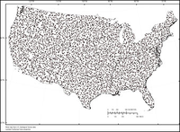
Between 2007 and 2013, the U.S. Geological Survey conducted a low-density (1 site per 1,600 square kilometers, 4,857 sites) geochemical and mineralogical survey of soils in the conterminous United States. The sampling protocol for the national-scale survey included, at each site, a sample from a depth of 0 to 5 centimeters, a composite of the soil A horizon, and a deeper sample from the soil C horizon or, if the top of the C horizon was at a depth greater than 1 meter, a sample from a depth of approximately 80–100 centimeters. The <2-millimeter fraction of each sample was analyzed for a suite of 45 major and trace elements by methods that yield the total or near-total elemental concentration. The major mineralogical components in the samples from the soil A and C horizons were determined by a quantitative X-ray diffraction method using Rietveld refinement. This report presents all the maps and statistical information for each determined element and mineral along with an interpretive section discussing the possible processes that caused the observed national-scale geochemical and mineralogical patterns. Most often, the geochemical and mineralogical patterns reflect the composition of the underlying soil parent material with some modifications caused by leaching of the more mobile elements (for example, calcium and sodium) in the humid areas of the country.
Suggested Citation
Smith, D.B., Solano, Federico, Woodruff, L.G., Cannon, W.F., and Ellefsen, K.J., 2019, Geochemical and mineralogical maps, with interpretation, for soils of the conterminous United States: U.S. Geological Survey Scientific Investigations Report 2017-5118, https://doi.org/10.3133/sir20175118. [Available as HTML.]
ISSN: 2328-0328 (online)
Study Area
Table of Contents
- Abstract
- Introduction
- Navigating the Website
- Information Sources
- Photo Credits
- Acknowledgments
| Publication type | Report |
|---|---|
| Publication Subtype | USGS Numbered Series |
| Title | Geochemical and mineralogical maps, with interpretation, for soils of the conterminous United States |
| Series title | Scientific Investigations Report |
| Series number | 2017-5118 |
| DOI | 10.3133/sir20175118 |
| Publication Date | April 25, 2019 |
| Year Published | 2019 |
| Language | English |
| Publisher | U.S. Geological Survey |
| Publisher location | Reston, VA |
| Contributing office(s) | Central Mineral and Environmental Resources Science Center, Eastern Mineral and Environmental Resources Science Center |
| Description | HTML Document |
| Country | United States |
| Online Only (Y/N) | Y |


