

Effects of Culverts on Habitat Connectivity in Streams—A Science Synthesis to Inform National Environmental Policy Act Analyses
Links
- Document: Report (9.19 MB pdf) , HTML , XML
- Related Work: Development on Ungulates and Small Mammals—A Science Synthesis to Inform National Environmental Policy Act Analyses
- Download citation as: RIS | Dublin Core
Acknowledgments
Funding for this work was provided by the Bureau of Land Management (BLM) National Operations Center. This synthesis project was supported in part by the U.S. Geological Survey (USGS) Ecosystems Mission Area—Land Management Research Program. Scientists of the Land Management Research Program work with resource managers to provide science and data products to help Federal, State, Tribal, and local agencies conserve, manage, and restore our Nation’s diverse socio-ecological systems, often with a focus on management of public lands and resources at landscape scales.
We thank Megan Gilbert (BLM), Nathan Kleist (USGS), Elroy Masters (BLM), Claudia Mengelt (USGS), Logan Maxwell and Elisabeth Teige (contractors to USGS), and John Tull (U.S. Fish and Wildlife Service) for their involvement in the conceptualization of this science synthesis and their support throughout the writing process. We also thank Sam Jordan, Emma Dietrich, and Alex Stoneburner (all USGS) for many in-depth discussions about the science synthesis concept. We thank Tim Hammond (BLM) for helping us understand many of the nuances of applying this synthesis to management decisions. We are very grateful to Michael C. Brown, Russell Japuntich, Sharmila Jepsen, and Matthew Varner (all BLM) for providing independent peer reviews.
Executive Summary
Background: The U.S. Geological Survey is working with Federal land management agencies to develop a series of science synthesis reports. These reports synthesize science information to support environmental effects analyses that agencies perform per the National Environmental Policy Act (NEPA). In this report, we synthesize science relevant to the effects of culverts on habitat connectivity and aquatic organism passage (AOP) in streams, and we focus particularly on freshwater fishes of the western United States.
How this report can inform a NEPA analysis: We organized the sections of this synthesis to inform the standard elements of NEPA environmental effects analyses. The report presents science information relevant to characterizing the proposed action and alternatives (section 1 of this report), characterizing the affected environment (section 2 of this report), and identifying issues for analysis and potential environmental effects for each issue using a clear analytical method (sections 3 and 4 of this report). We have developed a flowchart illustrating an example quantitative environmental effects analysis by gathering data about existing culverts, determining existing habitat connectivity in a watershed, and determining potential effects to habitat connectivity from a proposed culvert, which can be used to infer biological effects on fish that are present in the watershed (fig. 1).
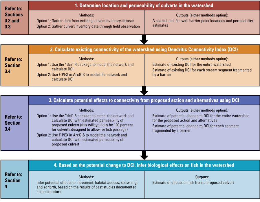
Flowchart illustrating an example environmental effects analysis of the effects of culverts on fish with references to the sections of this report that synthesize science information relevant to each methods step. [DCI, Dendritic Connectivity Index; FIPEX, Fish Passage Extension]
Effects of culverts on habitat connectivity in streams: Human effects to the habitat connectivity of stream systems can occur from any type of action involving the alteration of the geomorphic or hydrologic characteristics of the stream. Dams are an obvious and well-documented barrier to habitat connectivity and AOP, and effects to habitat connectivity from small, numerous barriers such as culverts are also well known. Culverts are commonly installed on stream crossings due to their low cost and ease of placement. Loss of habitat connectivity commonly occurs because of poor planning, poor construction, or degradation of culverts through time.
Culverts can alter many natural geomorphic and hydrologic processes, and their capacity to allow AOP is frequently cited as a concern. There are several mechanisms by which a poorly constructed or degraded culvert can prevent AOP. Undersized culverts often constrict flow, causing an increase in velocity that is impassable for many species. Erosion through time can lead to perched culverts, where the outlet of the culvert is located above the stream surface. The height of this perch often exceeds the jumping ability of fishes or other organisms, particularly smaller bodied individuals. Natural streams have substrate that provides reduced-velocity zones for upstream migrating fishes—a feature missing from poorly designed or degraded culverts.
Culverts have been shown to have a variety of effects on freshwater fish across species and at different spatial scales. Because of the interconnectedness of streams and watersheds, each stream crossing can affect fish population dynamics at local, watershed, and larger landscape scales. For example, decreased habitat connectivity caused by poorly designed culverts can lead to habitat fragmentation within stream systems. Decreased habitat connectivity has numerous well-documented effects on freshwater fish populations and communities and is recognized as a leading cause of declining freshwater diversity. When culverts are not complete barriers to upstream movement, they can have substantial effects on seasonal movements of fish. Several studies have documented the effects of culverts on preventing access to refuges and overwintering habitat, which can reduce population resilience to seasonal habitat variability. By preventing upstream movement, culverts also slow colonization after disturbance, such as a fish kill, relative to an unimpaired stream reach.
Land management agencies have outlined methods for assessing and designing culverts, and there are established methods for estimating their effects to habitat. The U.S. Department of Agriculture Forest Service has published a stream simulation guide, which is a comprehensive source of information for constructing ecologically and hydrologically functional culverts. The permeability, or passability of a culvert, can be estimated using quantitative methods. The Dendritic Connectivity Index is a commonly used quantitative metric that incorporates measures of culvert permeability to estimate habitat connectivity of entire stream systems. The Dendritic Connectivity Index can inform existing habitat connectivity of a system and quantify the effects to connectivity that may result from installing, modifying, or removing a culvert.
Conclusion: Information in this document draws from a broad sample of scientific literature covering assessments of individual culverts to habitat connectivity across watersheds. This document can be incorporated by reference in NEPA documentation, cited as supplemental information, or provide a general reference for understanding and identifying literature about the effects of culverts on habitat connectivity in streams.
Methods for developing this synthesis: Rutherford and others (2023) introduced a methodology for developing science syntheses to inform analyses conducted under the NEPA, and relevant text from that report is reproduced herein. This and other syntheses build on that foundation and methodology and apply it to new topics of management concern on western lands.
We conducted a structured search of scientific literature to find published science about the effects of culverts on habitat connectivity in streams, the resulting effects on aquatic organisms, and methods for analyzing culvert condition and quantifying stream habitat connectivity. This report was prepared in cooperation with staff from the Bureau of Land Management, U.S. Fish and Wildlife Service, and U.S. Geological Survey.
Purpose of this Report
Federal land management agencies permit and plan for many uses and activities on public lands across the United States. Per the National Environmental Policy Act of 1969 (NEPA; 42 U.S.C. 4321 et seq.), Federal agencies must analyze and disclose the potential environmental effects of major Federal actions that may significantly affect the quality of the human environment. Regulations for implementing the NEPA require the integrated use of the natural and social sciences in agency planning and decision processes (40 CFR §1501.2). Science is foundational to understanding how proposed Federal actions may affect natural resources, ecosystems, and human communities.
The purpose of this document is to synthesize scientific information about the effects of culverts (see the “Glossary” section of this report for definitions of bolded words) on habitat connectivity and aquatic organism passage (AOP). Science syntheses can be a useful mechanism for sharing science information with resource managers to inform their decisions (Seavy and Howell, 2010; Ryan and others, 2018). Science syntheses integrate knowledge and research findings to increase the generality, applicability, and accessibility of that information (Wyborn and others, 2018).
Although instream barriers can affect multiple components of stream systems such as floodplain connectivity, sedimentation, and woody debris transport—and have associated effects on the organisms that depend on them—this synthesis focuses primarily on how culverts alter freshwater fish habitat connectivity. Several comprehensive reviews provide information on the multitude of other effects of small instream barriers to river systems (Cocchiglia and others, 2012; Hoffman and others 2012; Frankiewicz and others, 2021). In perennial and intermittent river systems, culverts can, depending on their design and condition, serve as barriers to passage of aquatic organisms. Much of the aquatic infrastructure in the United States is aging and degrading, therefore negatively affecting habitat connectivity and limiting the movement of instream organisms (Perrin and Jhaveri, 2004; Park and others, 2008; Perkin and others, 2020). Implementing quantitative methods to estimate the effects of a barrier on habitat connectivity and following scientifically established, fish-friendly design can help maintain or improve habitat connectivity when constructing or modifying a culvert.
How to Use this Report
The content, structure, and section numbering of this report are designed to support NEPA analyses and reflect the steps of project planning and NEPA analyses (table 1). This report is meant to be a general reference and could be used, for example, as follows:
-
• incorporated by reference in NEPA documentation or to directly provide language for use in NEPA documentation (when incorporating this document by reference or drawing language from this report, please use the Lehrter and others [2024] suggested citation on page ii of this report),
-
• included as supplemental information, or
-
• used as a resource to gather literature and identify gaps in available science related to the management decision and context.
Table 1.
How the information in this report can inform steps in project planning and National Environmental Policy Act (NEPA) analysis.Caveats to Use of this Report
Please note this report is a science synthesis rather than a comprehensive literature review. In addition, this report does not provide all information necessary to conduct a full environmental effects analysis or make conclusions regarding the significance of environmental effects. Resource planners and managers may need to supplement the information contained in this synthesis with local information. Information about specific design elements of the proposed project, local landscape conditions, and potential environmental effects from factors other than culverts can complement the information contained in this synthesis. Additionally, this synthesis focuses on the effects of a culvert on connectivity and does not discuss the variety of other effects that a culvert can have on stream conditions and aquatic organisms.
We note that this document focuses on data about culverts and does not provide information about how to obtain aquatic organismic data. Information and data about the distribution and status of local aquatic taxa and their populations are crucial to informing the spatial extent of the analysis and understanding what species and how much habitat might be affected by altered connectivity.
Science Synthesis—Effects of Culverts on Habitat Connectivity in Streams
The following numbered sections are the science synthesis content of this report. The science synthesis sections are numbered to reflect a potential overall analysis workflow, as shown in figure 1, and facilitate internal referencing among sections. Our methods for conducting the literature search and synthesizing the science appear after this science synthesis section in the “Methods for Developing this Science Synthesis” section.
1. Culvert Installation or Modification
Culverts are a type of permanent, low-cost flow control structure that can be found at road-stream intersections. Because roads commonly intersect streams, culverts are prevalent across watersheds. Culverts are frequently installed, replaced, or modified on Federal public lands during activities such as fluid minerals development, logging, mining, and rights of way.
1.1. Culvert Construction
Culverts are constructed in a variety of sizes, materials, and shapes to accommodate hydraulic characteristics of a stream. Three common culvert types are round pipe culverts, pipe arch culverts, and box culverts (fig. 2). Round pipe culverts, ranging in size from 15 to 155 inches in diameter, are the most common and are suitable for smaller streams. Materials are generally reinforced concrete or corrugated metal pipe (Schall and others, 2012). Pipe arches have similar sizes to round pipe culverts but have a higher hydraulic capacity, giving them an advantage by providing a wider stream channel during low flows. Larger pipe arch culverts can be constructed with reinforced concrete or by bolting together pieces of corrugated metal (Schall and others, 2012). Lastly, box culverts are large reinforced concrete structures that are built to accommodate high flows and fish passage in larger streams. Any of the three culvert types can be designed bottomless to maintain the natural characteristics of the streambed, which improves AOP (Schall and others, 2012).
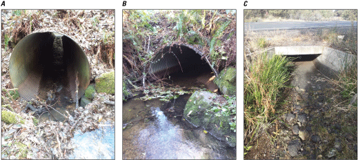
Images of three common types of culverts. Culvert A is a round pipe culvert constructed of corrugated metal. Culvert B is a bottomless pipe arch culvert constructed of corrugated metal. Culvert C is a box culvert constructed of reinforced concrete. Images courtesy of RoadXStr (a road-stream crossing database), Emily Heaston, U.S. Geological Survey.
1.1.1. Designing Culverts to Promote Habitat Connectivity
Several Federal agencies have published guidance for culvert design. The Bureau of Land Management (BLM) provides general technical guidance for culverts constructed during fluid minerals development. The BLM’s Gold Book states that culverts should “be designed for a 25-year or greater storm frequency and allow fish passage in perennial streams where fish are present” (U.S. Department of the Interior and U.S. Department of Agriculture, 2007, p. 27).
The Federal Highway Administration requires that any culvert that spans at least 20 feet of horizontal distance on any public land must comply with the National Bridge Inspection and Reporting Standards (23 CFR §650). The Federal Highway Administration also published a detailed guide outlining culvert design for maintaining habitat connectivity and AOP. The guide provides ecological and hydraulic information relevant to the design and construction of large culverts (Kilgore and others, 2010).
The U.S. Department of Agriculture Forest Service stream simulation guide provides detailed guidelines for designing and constructing road-stream crossings that maintain a high level of habitat connectivity and AOP (Cenderelli and others, 2011). Stream simulation aims to facilitate design of culverts that mimic the slope, structure, and dimensions of the natural streambed to minimize effects to longitudinal connectivity, hereafter referred to as “habitat connectivity.” The guide also includes a broad overview of managing watersheds for habitat connectivity, how to perform a site assessment to determine if the stream simulation approach is appropriate, preconstruction and postconstruction site assessment considerations, and many other details useful for culvert design.
1.2. Culvert Degradation
Culverts have a finite lifespan and can degrade to the point that they do not allow for AOP (Perrin and Dwivedi, 2006; Eisenhour and Floyd, 2013). Failing culverts incur economic costs, leading to a need for government agencies to regularly assess culvert condition (Perrin and Jhaveri, 2004; Perrin and Dwivedi, 2006). Case studies have documented that large concentrations of degraded culverts within a watershed affect AOP. In Alberta’s boreal forest, Park and others (2008) assessed 374 culverts and found that 50 percent were hanging, or “perched,” above the stream surface at the outlet of the culvert.
1.3. Culvert Removal and Replacement
Removing or replacing dilapidated or poorly designed culverts is a technique for restoring habitat connectivity and AOP (Amtstaetter and others, 2017). Projects that involve removing or replacing a culvert are situation-specific in their requirements but often involve many of the same hydrologic considerations (for example, temporarily redirecting flow, placing gradient control structures, and stabilizing stream banks) as constructing a new culvert (Bureau of Land Management, 2010; Bureau of Land Management, 2017).
Section 2 Highlights
-
• Habitat connectivity and its importance: Habitat connectivity refers to the ease or hindrance of movement of organisms and materials within a watershed. In aquatic riverine systems, movement—particularly for aquatic species like fish—occurs longitudinally along the river channel and within the watershed. Habitat connectivity plays a crucial role in supporting individual species and species assemblages.
-
• Types of barriers affecting connectivity: Natural and human-induced features can impede habitat connectivity. Movement can be hindered by natural barriers such as waterfalls, cascades, and seasonal drying. Human-made barriers, including dams, weirs, low-water crossings, and culverts, may significantly affect habitat connectivity. The effects of dams on stream biota are well documented, and smaller barriers at road crossings, like culverts, are prevalent and collectively have a substantial effect on habitat connectivity.
-
• Prevalence of small barriers: Studies have shown that the number of culverts can far exceed that of dams in certain North American watersheds. Therefore, the cumulative effects of these small barriers may be greater than those of larger dams, emphasizing the importance of addressing culverts’ effects on habitat connectivity.
2.1. Habitat Connectivity Basics
Habitat connectivity describes the degree to which the landscape facilitates or impedes movement of organisms and materials between different locations in the watershed (McGarigal and Cushman, 2002). In aquatic riverine systems, movement (for aquatic obligates such as fish) is longitudinal (in other words, running upriver and downriver) along the river channel and within a watershed (Cote and others, 2009). Benda and others (2004) and Brown and Swan (2010) applied many existing landscape ecological concepts to aquatic ecosystems, noting that habitat connectivity within watersheds controls the distribution of available habitats, which in turn supports individual species and species assemblages. Fragmentation from human activity is a leading cause of freshwater biodiversity loss (Fischer and Lindenmayer, 2007; Perkin and others, 2015).
2.2. What Types of Barriers Can Affect Habitat Connectivity?
Natural and human-made features can impede habitat connectivity. Examples of natural barriers include waterfalls, cascades, seasonal drying, and unsuitable conditions such as excessively warm temperatures. Movement barriers associated with stream drying, unsuitably warm temperatures, or other altered instream conditions can also be related to human effects. Human-constructed barriers to habitat connectivity include flow control structures such as dams, weirs, low-water crossings, and culverts. The effects of dams on stream biota are well documented (Baxter, 1977; Murchie and others, 2008; Bellmore and others 2017), but researchers have also extensively documented the effects of smaller barriers that are often at road crossings (Anderson and others 2012; Hoffman and others 2012). Because of their prevalence, the effects of these smaller barriers on habitat connectivity may collectively far exceed those of dams (Januchowski-Hartley and others, 2013; Diebel and others, 2015). Respectively, Januchowski-Hartley and others (2013) and Diebel and others (2015) documented a ratio of 38 times and 24 times more culverts than dams in two separate North American watersheds.
3. Tools for Assessing Habitat Connectivity
Several modeling techniques are available to quantify habitat connectivity related to barriers in a watershed. Comparing estimated habitat connectivity in the watershed with and without current barriers can help resource managers understand the cumulative effects of human-made barriers in the watershed (for example, Mims and others, 2019).
Section 3 Highlights
-
• Factors affecting extent of analysis: When conducting habitat connectivity analysis, the spatial extent should align with the typical movement range of fish populations. Life history characteristics like species-specific differences in movement behavior also affect the extent of the analysis.
-
• Data requirements: Conducting a baseline habitat connectivity analysis using tools like the “dci” R package (Arkilanian, 2023) or the ArcMAP Fish Passage Extension (FIPEX; Oldford and others, 2022) requires comprehensive data on existing barriers in the watershed. Culvert location, condition, and other characteristics can be obtained from various sources such as online databases or field data collection.
-
• Assessing culvert permeability: Permeability assessment involves evaluating culvert characteristics that affect fish movement. Although no standardized method exists, tools like FishXing (Furniss and others, 2006) and resources from the North Atlantic Aquatic Connectivity Collaborative offer guidance for estimating culvert permeability.
-
• Estimating fish habitat connectivity: The DCI can be measured using the “dci” R package or FIPEX. Accurate results depend on the quality and completeness of the barrier inventory data within the study area.
The Dendritic Connectivity Index (DCI; Cote and others, 2009) models watersheds as networks of habitat in which the absence of barriers yields a DCI value of 100. The DCI is affected by the number, location, and permeability of barriers within the watershed. As impermeable barriers are added, the DCI declines from its maximum value of 100, indicating total connectivity, to as low as 0, indicating minimum connectivity. An application of the DCI in the Great Plains indicated that the DCI is sensitive to the effects of fragmentation by road crossings; DCI decreases with increasing fragmentation (Perkin and Gido, 2012).
3.1. Choosing the Spatial Extent of the Habitat Connectivity Analysis
The spatial extent at which an individual barrier affects aquatic organisms, and subsequently the spatial extent at which to conduct a habitat connectivity analysis, varies. An important factor to consider is the extent of the ranges of the populations that move through the location of the barrier. For example, if a fish population typically moves within a 10-digit hydrologic unit watershed, the analysis should cover that entire watershed.
The movement of individual fish species is dependent on life history characteristics, which should be considered when determining the extent of the analysis. Body size is directly correlated with swimming speed, making it more difficult for juveniles and smaller species to overcome fast flow rates (Ojanguren and Braña, 2003; Cano-Barbacil and others, 2020). Differences in propensity to movement also differ among species and populations; for example, some fish require long migration distances while others can adopt a resident strategy (Hoffman and others, 2012; Brodersen and others, 2014).
3.2. Data Needed to Estimate Habitat Connectivity in a Watershed
To conduct a baseline habitat connectivity analysis, a comprehensive dataset of existing barriers within the proposed watershed is needed. Culvert location and condition information can be obtained either from existing sources or field data collection. Although systematic inventories of human-constructed barriers to habitat connectivity are missing or lacking in many North American watersheds (Januchowski-Hartley and others, 2013), particularly in the Intermountain West (Dunham and others, 2023), several barrier inventory databases are available. For example, the Southeast Aquatic Resources Partnership provides a growing list of human-made barriers to habitat connectivity for every State except Hawaii. Their Aquatic Barrier Prioritization Tool is a geospatial web interface that summarizes road crossings and dams as barriers to habitat connectivity within specific States, hydrologic units, or ecoregions (National Aquatic Barrier Inventory and Prioritization Tool, 2023). This tool also provides downloadable spatial data for more in-depth analyses. However, because the tool is based on inventoried barriers, areas with high concentrations of barriers may simply reflect areas with more complete inventories. Other tools such as RoadxStr (a road-stream crossing database) are also in development to meet needs for rapid surveys to address large numbers of crossings in a short timeframe (Emily Heaston, U.S. Geological Survey, written commun., 2023).
When field data are feasible to collect, they can supplement or provide more up-to-date information than online databases. The Oregon/Washington BLM office recently published a spatial data standard for collecting data related to culverts (Bureau of Land Management, 2020). The data standard provides detailed definitions of all data to be collected regarding culverts, details of data collection and input, and other relevant information.
If field data are not available or financially or logistically impractical to collect or analyze, case studies may be cited and used to infer the potential effects of changes in habitat connectivity on watersheds. Several example habitat connectivity analyses are included in section “4.2.2. Responses of Fish Populations to Altered Habitat Connectivity” of this document.
3.3. Assessing the Permeability of a Culvert
Permeability is an estimate of the ability of an organism to pass through a potential barrier culvert. The spatial extent of the connectivity analysis may affect the intensity of the sampling approach chosen for assessing permeability. Although there is no standardized method for assessing the permeability of culverts, common survey methods assess many of the same culvert characteristics. These characteristics often include road condition, hydrologic information, culvert material, stream substrate, and characteristics of the inlet and outlet such as grade, dimensions, and drop distance to the water surface.
The North Atlantic Aquatic Connectivity Collaborative provides instruction manuals, data forms, and a scoring system for assessing culverts on their website (University of Massachusetts Amherst, 2023). In addition, they provide online training for field assessment, a database of assessed crossings, and web-based tools for identifying high-priority watersheds, crossings, and assessments.
An older but common tool for estimating permeability is FishXing, which was published by the U.S. Department of Agriculture Forest Service (Furniss and others, 2006). The tool models culvert hydraulics and fish swimming performance, providing an estimate of permeability that can be incorporated into a habitat connectivity analysis. Data required for estimating permeability consist of basic site information, culvert data, and demographic information about fish species (in other words, species present or potentially present, at minimum). The tool models the estimated permeability (0–100 percent) of the culvert with user-entered data for the species of interest. It also estimates other barrier-specific metrics, including passable and impassable flow ranges and whether there is an outlet drop that serves as a barrier for the species of interest.
3.4. Estimating Fish Habitat Connectivity in a Stream or Stream Network with Culverts
The DCI can be measured using one of several tools. The “dci” R package is being actively developed and provides a straightforward, programmable method of calculating the DCI for a watershed (R Core Team, 2023; Arkilanian, 2023). ArcMap Fish Passage Extension (FIPEX; Oldford and others, 2022) is another tool that allows a user to calculate and visualize the DCI within ArcMap. Regardless of method, the quality of a habitat connectivity analysis depends on the quality and completeness of the existing inventory of barriers within the study area. We describe these two quantitative methods in more detail in appendixes 1 and 2 and provide an example script for running an analysis of connectivity using the “dci” R package in appendix 3.
Section 4 Highlights
-
• Culvert characteristics blocking aquatic organism passage: Culverts can impede the movement of aquatic organisms, particularly fish, and significantly affect stream hydrology, geomorphology, and biota. Channel constriction, perched outlets, and extreme flow velocities are key culvert characteristics that hinder aquatic organism passage.
-
• Effects on fish: Culverts serve as barriers to the daily and seasonal movements of fish, disrupting their access to habitat and essential resources like cold water refuges. The fragmentation caused by culverts leads to disconnected habitats and isolated subpopulations, ultimately contributing to biodiversity loss.
-
• Responses of fish populations to altered connectivity: Fragmentation by culverts reduces community resilience and can result in lower fish species richness and abundance at affected sites. Properly designed culverts can enhance habitat connectivity and improve access for fish.
-
• Special considerations: Culverts can also play a role in managing aquatic invasive species. Intentionally impeding habitat connectivity using culverts may limit competition between native and invasive species, prevent hybridization, and help control the spread of invasive species. Management decisions and assessments regarding culvert use as an invasive species management tool should be considered carefully because of the potential of a culvert to affect native species.
4.1. What Characteristics of Culverts Block Aquatic Organism Passage?
Culverts can prevent the movement of aquatic organisms (Warren and Pardew, 1998) and have major effects on stream hydrology, geomorphology, and biota (Frankiewicz and others, 2021). Warren and Pardew (1998) conducted a thorough mark-recapture study of the ability of three families of small-bodied fish to pass through a variety of culvert designs (pipe culvert, slab, open-box) relative to an unimpaired, natural reach. They demonstrated that (1) fish passage, expressed as mean daily movement, was significantly reduced at pipe culverts relative to open-box culverts, ford crossings, and natural reaches and (2) water velocity at crossings was inversely related to fish movement. Further studies have confirmed that increases in flow velocity due to constriction by pipe culverts reduce or prevent AOP (Schaefer and others, 2003; Macdonald and Davies, 2007). More recent research has acknowledged that fish often use reduced-velocity zones to lower energetic costs. Roughness in a culvert can improve a fish’s ability to pass through by creating reduced-velocity zones that lower energetic costs (Amtstaetter and others, 2017; Rodgers and others, 2017).
When streamflow is low, some culverts may be perched above the stream surface. Perched culverts can be particularly difficult to navigate for small-bodied fish (Anderson and others, 2012). Shallow depths resulting from low flows through a culvert can prevent fish movement. Even when high streamflow is sufficient to submerge the outlet, the constricted flow through the culvert may be too fast for small-bodied fish to swim against (Furniss and others, 2000). Examples of culverts in various conditions can be seen in figure 3.
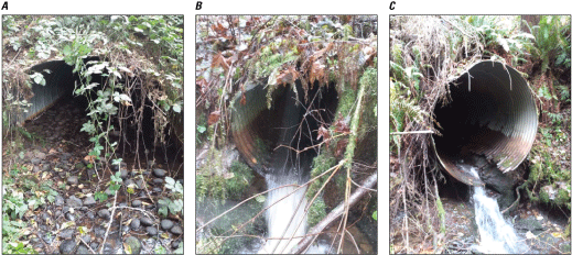
Images of culvert outlets in various conditions. Culvert A is a bottomless, corrugated metal pipe-arch culvert that maintains a natural substrate through the outlet. Culvert B is a corrugated metal pipe culvert with a perched outlet and increased flow rates due to flow constriction. Culvert C is a corrugated metal pipe culvert with a perched outlet and obvious degradation (rusting) through the bottom of the culvert. Images courtesy of RoadXStr (a road-stream crossing database), Emily Heaston, U.S. Geological Survey.
4.2. Effects of Culverts on Fish
Fish move within a river system on a daily and seasonal basis for many reasons, such as finding resources, accessing refuges, spawning, and colonization. Culverts can serve as barriers to movement and dispersal and fragment habitat. Broadly, increased habitat fragmentation in river systems often results in disconnected habitat and isolated subpopulations of organisms through time, leading to a loss of biodiversity (Perkin and Gido, 2012).
4.2.1. Daily and Seasonal Movement of Freshwater Fish
Fish engage in movements at different temporal scales, all of which are susceptible to interruption by culverts (table 2). Three dominant families of small-bodied fish (Centrarchidae [sunfishes and black bass], Cyprinidae [minnows and carps], and Fundulidae [topminnows and killifishes]) were documented making daily movements through stream crossings seeking different habitat patches (Warren and Pardew, 1998). Daily and seasonal movements are also important for maintaining the capacity of fish to use diverse habitats that meet their needs for feeding, migration, refuge, and reproduction (Schlosser, 1995). For example, habitat fragmentation by instream barriers has been shown to reduce access to cold water refuges (Schaefer and others, 2003; Petty and others, 2012), which is of particular concern as the effects of climate change, such as extended drought, warmer waters, reduced base flows, and increased flooding (Reidmiller and others, 2018), continue to become more prevalent (Ebersole and others, 2020). Seasonal fish movements to suitable overwintering habitat can also be blocked by impassable dams and culverts (Chisholm and others, 1987; Sethi and others, 2021). Lastly, culverts can prevent upstream migration for the many freshwater fish species that migrate long distances for spawning (Crowe, 1962; Fausch and Young, 1995; Compton and others, 2008).
Table 2.
Literature describing specific effects of barrier culverts to fish.[Each table spanner contains an effect of a barrier on fish. The rows below the spanners list the taxa for which each effect has been studied, the barrier type assessed in the study, and relevant citations. We note that this is not a comprehensive list of literature about these specific topics, but rather a set of illustrative examples (see Hoffman and others [2012] for additional examples)]
| Study taxa | Barrier type | Citation |
|---|---|---|
| Sunfishes and black bass (Centrarchidae), minnows (Cyprinidae), and topminnows and killifishes (Fundulidae) | Culvert | Warren and Pardew (1998) |
| Brook trout (Salvelinus fontinalis) | Unspecified | Petty and others (2012) |
| Leopard darter (Percina pantherina) | Culvert | Schaefer and others (2003) |
| Coho salmon (Oncorhynchus kisutch) | Culvert and dam | Sethi and others (2021) |
| Brook trout (Salvelinus fontinalis) | Natural barriers | Chisholm and others (1987) |
| Bluehead sucker (Catostomus discobolus), flannelmouth sucker (Catostomus latipinnis), and roundtail chub (Gila robusta) | Dam | Compton and others (2008) |
| Chinook salmon (Oncorhynchus tshawytscha) | Dam | Deriso and others (2001) |
| Temperate stream fish communities (both studies) | Culvert | Freeman and others (2021) |
| Unspecified | Detenbeck and others (1992) |
4.2.2. Responses of Fish Populations to Altered Habitat Connectivity
Freshwater fish respond to altered habitat connectivity in multiple ways. In Georgia, only 3 of 11 fish species recolonized a headwater stream 18.5 months after a chemical spill at the headwaters of a highly culvert-fragmented watershed, indicating decreased community resilience resulting from fragmentation by culverts (Freeman and others, 2021). In a study of 97 sites in southeast Oklahoma, fish species richness (a count of unique species) was lower at culvert-affected sites compared to free-flowing sites, and the most highly degraded culverts had the greatest effects on species abundance and richness (Fleming and Neeson, 2020). Chelgren and Dunham (2015) modeled habitat connectivity for a watershed in Oregon by comparing replaced crossings with existing crossings, concluding that the new crossing design increased fish passage for the multiple fish species considered.
4.2.3. Special Considerations—Culverts and Aquatic Invasive Species
Culverts may also affect the diversity, abundance, resilience, and reproduction of invasive aquatic species (for example, see Kerby and others, 2005), making culverts an invasive species management tool in some circumstances. Intentionally impeding habitat connectivity using a culvert may prevent competition between native and invasive fish species (Fausch 1989; Bowie and others, 2018), prevent unwanted hybridization (Behnke, 1992; Neville and Dunham, 2011), and limit the spread of invasive species (Milt and others, 2018). Fausch and others (2006, 2009) provided an extensive discussion of this issue with reference to management decisions and assessments.
Methods for Developing this Science Synthesis
Rutherford and others (2023) introduced a methodology for developing science syntheses to inform analyses conducted under the National Environmental Policy Act (NEPA). This and other syntheses build on that foundation and methodology and apply it to new topics of management concern on western lands. Therefore, relevant text from these reports is reproduced herein.
We used a literature search to gather science relevant to culverts and habitat connectivity. We sought information relevant to conducting environmental effects analyses per the NEPA (Carter and others, 2023), including background data, studies that describe the effects of culverts on habitat connectivity or aquatic organisms, methods for analyzing culvert condition and habitat connectivity, and effective culvert design.
We used the Python-based BiblioSearch tool developed by the U.S. Geological Survey (Kleist and Enns, 2021) to conduct a scientific database search to gather recent (2017–22) literature relevant to the effects of culverts on habitat connectivity and aquatic organisms. We used the search terms “'culvert' AND ('stream' OR 'river' OR 'lotic') AND ('AOP' OR 'passage' OR 'barrier' OR 'connectivity')” to search three databases (Web of Science, Scopus, and ScienceBase) for relevant literature published within the last 5 years (2017–22). This search yielded 147 publications, which we reviewed to confirm their relevance to culverts, habitat connectivity, and AOP. We then used a backwards snowballing method (Wäldchen and Mäder, 2018) starting from the most relevant, highly cited studies to identify seminal publications related to the topic of our literature search. This method allowed us to obtain a core list of literature to better understand the current (2017–22) state of the science and seminal studies that provided foundational information. We sought studies related to fish passage in river systems that gave no preference to diadromous or potamodromous taxa. Finally, we synthesized the scientific information from the search into this document with the goal of informing environmental effects analyses for resource management on Federal public lands.
We synthesized information returned in these searches according to our objective to inform NEPA analyses. Rather than reporting all literature we found, we synthesized only the literature applicable to informing analyses of the potential effects of culvert installation or modification on connectivity and aquatic organisms. As such, this synthesis does not constitute a comprehensive literature review of all effects of culverts on aquatic organisms, and it is possible that we may have missed articles not identified through our literature search methods.
Throughout the development of this report, we worked with staff from the BLM, U.S. Fish and Wildlife Service, and U.S. Geological Survey to coproduce this document (Beier and others, 2017). We refined the structure and content of the report through close collaboration with multiple BLM staff throughout scoping, writing, and review.
References Cited
American Fisheries Society, 2023, What is aquatic organism passage/fish passage?: American Fisheries Society web page, accessed October 24, 2023, at https://units.fisheries.org/fishpassagejointcommittee/about/what-is-aquatic-organism-passage-fish-passage/.
Amtstaetter, F., O’Connor, J., Borg, D., Stuart, I., and Moloney, P., 2017, Remediation of upstream passage for migrating Galaxias (Family: Galaxiidae) through a pipe culvert: Fisheries Management and Ecology, v. 24, no. 3, p. 186–192, accessed August 20, 2022, at https://doi.org/10.1111/fme.12211.
Anderson, G.B., Freeman, M.C., Freeman, B.J., Straight, C.A., Hagler, M.M., and Peterson, J.T., 2012, Dealing with uncertainty when assessing fish passage through culvert road crossings: Environmental Management, v. 50, no. 3, p. 462–477, accessed October 13, 2022, at https://doi.org/10.1007/s00267-012-9886-6.
Arkilanian, A., 2023, dci—Calculate the Dendritic Connectivity in river networks, R package version 0.0.0.9000: GitHub software release, accessed June 1, 2023, at https://github.com/aarkilanian/dci.
Baxter, R.M., 1977, Environmental effects of dams and impoundments: Annual Review of Ecology and Systematics, v. 8, p. 255–283, accessed October 13, 2022, at https://doi.org/10.1146/annurev.es.08.110177.001351.
Beier, P., Hansen, L.J., Helbrecht, L., and Behar, D., 2017, A how-to guide for coproduction of actionable science: Conservation Letters, v. 10, no. 3, p. 288–296, accessed July 25, 2023, at https://doi.org/10.1111/conl.12300.
Bellmore, R., Duda, J.J., Craig, L.S., Greene, S.L., Torgersen, C.E., Collins, M.J., and Vittum, K., 2017, Status and trends of dam removal research in the United States: Wiley Interdisciplinary Reviews: Water, v. 4, no. 2, article e1164, accessed June 2, 2023, at https://doi.org/10.1002/wat2.1164.
Benda, L., Poff, N.L., Miller, D., Dunne, T., Reeves, G., Pess, G., and Pollock, M., 2004, The network dynamics hypothesis—How channel networks structure riverine habitats: BioScience, v. 54, no. 5, p. 413–427, accessed August 30, 2022, at https://doi.org/10.1641/0006-3568(2004)054[0413:TNDHHC]2.0.CO;2.
Bowie, S., Jack, D., and Nelson, D., 2018, Use of built barriers in New Zealand streams as a conservation management tool—International Conference on Engineering and Ecohydrology for Fish Passage, December 13, 2018: Amherst, Mass., University of Massachusetts Amherst, 23 p., accessed February 2, 2023, at https://scholarworks.umass.edu/fishpassage_conference/2018/December13/25.
Brodersen, J., Chapman, B.B., Nilsson, P.A., Skov, C., Hansson, L.-A., and Brönmark, C., 2014, Fixed and flexible—Coexistence of obligate and facultative migratory strategies in a freshwater fish: PLOS ONE, v. 9, no. 3, article e90294, accessed July 25, 2023, at https://doi.org/10.1371/journal.pone.0090294.
Brown, B.L., and Swan, C.M., 2010, Dendritic network structure constrains metacommunity properties in riverine ecosystems: Journal of Animal Ecology, v. 79, no. 3, p. 571–580, accessed August 30, 2022, at https://doi.org/10.1111/j.1365-2656.2010.01668.x.
Bureau of Land Management, 2010, Abrams Creek fish passage culvert replacement: Bureau of Land Management Glenwood Springs Field Office, Environmental Assessment no. DOI-BLM-CO-N040-2010-0021-EA, 42 p., accessed September 20, 2023, at https://eplanning.blm.gov/eplanning-ui/project/109143/570.
Bureau of Land Management, 2017, Steel Creek tributary culvert removals: Bureau of Land Management Myrtlewood Field Office, Documentation of NEPA Adequacy (DNA) no. DOI-BLM-ORWA-C040-2017-0001-DNA, 6 p., accessed September 20, 2023, at https://eplanning.blm.gov/eplanning-ui/project/83615/570.
Cano-Barbacil, C., Radinger, J., Argudo, M., Rubio-Gracia, F., Vila-Gispert, A., and García-Berthou, E., 2020, Key factors explaining critical swimming speed in freshwater fish—A review and statistical analysis for Iberian species: Scientific Reports, v. 10, no. 1, article 18947, accessed July 25, 2023, at https://doi.org/10.1038/s41598-020-75974-x.
Carter, S.K., Haby, T.S., Meineke, J.K., Foster, A.C., McCall, L.E., Espy, L.D., Gilbert, M.A., Herrick, J.E., and Prentice, K.L., 2023, Prioritizing science efforts to inform decision making on public lands: Frontiers in Ecology and the Environment, v. 21, no. 10, 8 p., accessed September 14, 2023, at https://doi.org/10.1002/fee.2672.
Cenderelli, D.A., Clarkin, K., Gubernick, R.A., and Weinhold, M., 2011, Stream simulation for aquatic organism passage at road-stream crossings: Transportation Research Record, v. 2203, no. 1, p. 36–45, accessed September 7, 2022, at https://doi.org/10.3141/2203-05.
Chelgren, N.D., and Dunham, J.B., 2015, Connectivity and conditional models of access and abundance of species in stream networks: Ecological Applications, v. 25, no. 5, p. 1357–1372, accessed October 12, 2022, at https://doi.org/10.1890/14-1108.1.
Chisholm, I.M., Hubert, W.A., and Wesche, T.A., 1987, Winter stream conditions and use of habitat by brook trout in high-elevation Wyoming streams: Transactions of the American Fisheries Society, v. 116, no. 2, p. 176–184, accessed August 31, 2022, at https://doi.org/10.1577/1548-8659(1987)116<176:WSCAUO>2.0.CO;2.
Cocchiglia, L., Purcell, P.J., and Kelly-Quinn, M., 2012, A critical review of the effects of motorway river-crossing construction on the aquatic environment: Freshwater Reviews, v. 5, no. 2, p. 141–168, accessed February 2, 2023, at https://doi.org/10.1608/FRJ-5.2.489.
Compton, R.I., Hubert, W.A., Rahel, F.J., Quist, M.C., and Bower, M.R., 2008, Influences of fragmentation on three species of native warmwater fishes in a Colorado River basin headwater stream system, Wyoming: North American Journal of Fisheries Management, v. 28, no. 6, p. 1733–1743, accessed June 7, 2023, at https://doi.org/10.1577/M07-226.1.
Cote, D., Kehler, D.G., Bourne, C., and Wiersma, Y.F., 2009, A new measure of longitudinal connectivity for stream networks: Landscape Ecology, v. 24, no. 1, p. 101–113, accessed October 11, 2022, at https://doi.org/10.1007/s10980-008-9283-y.
Crowe, W.R., 1962, Homing behavior in walleyes: Transactions of the American Fisheries Society, v. 91, no. 4, p. 350–354, accessed November 2, 2022, at https://doi.org/10.1577/1548-8659(1962)91[350:HBIW]2.0.CO;2.
Deriso, R.B., Marmorek, D.R., and Parnell, I.J., 2001, Retrospective patterns of differential mortality and common year-effects experienced by spring and summer chinook salmon (Oncorhynchus tshawytscha) of the Columbia River: Canadian Journal of Fisheries and Aquatic Sciences, v. 58, no. 12, p. 2419–2430, accessed August 30, 2022, at https://doi.org/10.1139/f01-172.
Detenbeck, N.E., DeVore, P.W., Niemi, G.J., and Lima, A., 1992, Recovery of temperate-stream fish communities from disturbance—A review of case studies and synthesis of theory: Environmental Management, v. 16, no. 1, p. 33–53, accessed November 2, 2022, at https://doi.org/10.1007/BF02393907.
Diebel, M.W., Fedora, M., Cogswell, S., and O’Hanley, J.R., 2015, Effects of road crossings on habitat connectivity for stream-resident fish: River Research and Applications, v. 31, no. 10, p. 1251–1261, accessed October 13, 2022, at https://doi.org/10.1002/rra.2822.
Dunham, J., Hirsch, C., Gordon, S., Flitcroft, R., Chelgren, N., Snyder, M., Hockman-Wert, D., Reeves, G., Andersen, H., Anderson, S., Battaglin, W., Black, T., Brown, J., Claeson, S., Hay, L., Heaston, E., Luce, C., Nelson, N., Penn, C., and Raggon, M., 2023, Northwest Forest Plan—The first 25 years (1994–2018)—Watershed condition status and trends: U.S. Department of Agriculture Forest Service, Pacific Northwest Research Station, General Technical Report PNW-GTR-1010, 184 p., accessed June 12, 2023, at https://doi.org/10.2737/PNW-GTR-1010.
Ebersole, J.L., Quiñones, R.M., Clements, S., and Letcher, B.H., 2020, Managing climate refugia for freshwater fishes under an expanding human footprint: Frontiers in Ecology and the Environment, v. 18, no. 5, p. 271–280, accessed August 31, 2022, at https://doi.org/10.1002/fee.2206.
Eisenhour, D.J., and Floyd, M.A., 2013, A culvert acts as a barrier for blackside dace (Chrosomus cumberlandensis) movements in Lick Fork, Kentucky: Southeastern Naturalist, v. 12, no. 4, p. 82–91, accessed September 14, 2023, at https://doi.org/10.1656/058.012.s406.
Fausch, K., 1989, Do gradient and temperature affect distribution of, and interactions between, brook charr (Salvelinus fontinalis) and other resident salmonids in streams?: Physiology and Ecology Japan, Special Volume 1, p. 303–322, accessed September 11, 2023, at https://cir.nii.ac.jp/crid/1573950399840065152.
Fausch, K.D., Rieman, B.E., Dunham, J.B., Young, M.K., and Peterson, D.P., 2009, Invasion versus isolation—Trade-offs in managing native salmonids with barriers to upstream movement: Conservation Biology, v. 23, no. 4, p. 859–870, accessed June 7, 2023, at https://doi.org/10.1111/j.1523-1739.2008.01159.x.
Fausch, K.D., Rieman, B.E., Young, M.K., and Dunham, J.B., 2006, Strategies for conserving native salmonid populations at risk from nonnative fish invasions—Tradeoffs in using barriers to upstream movement: U.S. Department of Agriculture Forest Service, Rocky Mountain Research Station, General Technical Report RMRS-GTR-174, 50 p., accessed June 7, 2023, at https://doi.org/10.2737/RMRS-GTR-174.
Fischer, J., and Lindenmayer, D.B., 2007, Landscape modification and habitat fragmentation—A synthesis: Global Ecology and Biogeography, v. 16, no. 3, p. 265–280, accessed August 30, 2022, at https://doi.org/10.1111/j.1466-8238.2007.00287.x.
Fleming, P., and Neeson, T.M., 2020, Effects of transportation infrastructure on fishes in the Ozark and Ouachita Mountains: Transportation Research Part D: Transport and Environment, v. 86, article 102451, accessed October 12, 2022, at https://doi.org/10.1016/j.trd.2020.102451.
Frankiewicz, P., Radecki-Pawlik, A., Wałęga, A., Łapińska, M., and Wojtal-Frankiewicz, A., 2021, Small hydraulic structures, big environmental problems—Is it possible to mitigate the negative impacts of culverts on stream biota?: Environmental Reviews, v. 29, no. 4, p. 510–528, accessed August 30, 2022, at https://doi.org/10.1139/er-2020-0126.
Freeman, M., Elkins, D., Maholland, P., Butler, Z., Kleinhans, M., Skaggs, J., Stowe, E., Straight, C., and Wenger, S., 2021, Slow recovery of headwater-stream fishes following a catastrophic poisoning event: Journal of Fish and Wildlife Management, v. 12, no. 2, p. 362–372, accessed October 12, 2022, at https://doi.org/10.3996/JFWM-20-080.
Furniss, M., Love, M., Firor, S., Moynan, K., Llanos, A., Guntle, J., and Gubernick, R., 2006, FishXing, version 3: U.S. Department of Agriculture Forest Service software release, accessed June 6, 2023, at https://www.fs.usda.gov/biology/nsaec/fishxing/resources.html.
Januchowski-Hartley, S.R., McIntyre, P.B., Diebel, M., Doran, P.J., Infante, D.M., Joseph, C., and Allan, J.D., 2013, Restoring aquatic ecosystem connectivity requires expanding inventories of both dams and road crossings: Frontiers in Ecology and the Environment, v. 11, no. 4, p. 211–217, accessed August 30, 2022, at https://doi.org/10.1890/120168.
Kerby, J.L., Riley, S.P.D., Kats, L.B., and Wilson, P., 2005, Barriers and flow as limiting factors in the spread of an invasive crayfish (Procambarus clarkii) in southern California streams: Biological Conservation, v. 126, no. 3, p. 402–409, accessed September 29, 2023, at https://doi.org/10.1016/j.biocon.2005.06.020.
Kleist, N., and Enns, K., 2021, USGS BiblioSearch—A python tool to facilitate searching, cleaning, and compiling of literature citations from multiple databases, version 1.0.0: U.S. Geological Survey software release, accessed November 16, 2022, at https://doi.org/10.5066/P9EW8BO5.
Macdonald, J.I., and Davies, P.E., 2007, Improving the upstream passage of two galaxiid fish species through a pipe culvert: Fisheries Management and Ecology, v. 14, no. 3, p. 221–230, accessed October 17, 2022, at https://doi.org/10.1111/j.1365-2400.2007.00546.x.
McGarigal, K., and Cushman, S.A., 2002, Comparative evaluation of experimental approaches to the study of habitat fragmentation effects: Ecological Applications, v. 12, no. 2, p. 335–345, accessed November 2, 2022, at https://doi.org/10.1890/1051-0761(2002)012[0335:CEOEAT]2.0.CO;2.
Merriam-Webster, 2023a, [Definition of] diadromous, accessed October 25, 2023, at https://www.merriam-webster.com/dictionary/diadromous.
Merriam-Webster, 2023b, [Definition of] potamodromous, accessed October 25, 2023, at https://www.merriam-webster.com/dictionary/potamodromous.
Milt, A.W., Diebel, M.W., Doran, P.J., Ferris, M.C., Herbert, M., Khoury, M.L., Moody, A.T., Neeson, T.M., Ross, J., Treska, T., O’Hanley, J.R., Walter, L., Wangen, S.R., Yacobson, E., and McIntyre, P.B., 2018, Minimizing opportunity costs to aquatic connectivity restoration while controlling an invasive species: Conservation Biology, v. 32, no. 4, p. 894–904, accessed February 2, 2023, at https://doi.org/10.1111/cobi.13105.
Mims, M.C., Day, C.C., Burkhart, J.J., Fuller, M.R., Hinkle, J., Bearlin, A., Dunham, J.B., DeHaan, P.W., Holden, Z.A., and Landguth, E.E., 2019, Simulating demography, genetics, and spatially explicit processes to inform reintroduction of a threatened char: Ecosphere, v. 10, no. 2, accessed June 6, 2023, at https://doi.org/10.1002/ecs2.2589.
Minnesota Department of Natural Resources, 2023, About connectivity: Minnesota Department of Natural Resources website, accessed October 25, 2023, at https://www.dnr.state.mn.us/whaf/5-component/connectivity.html.
Murchie, K.J., Hair, K.P.E., Pullen, C.E., Redpath, T.D., Stephens, H.R., and Cooke, S.J., 2008, Fish response to modified flow regimes in regulated rivers—Research methods, effects and opportunities: River Research and Applications, v. 24, no. 2, p. 197–217, accessed October 13, 2022, at https://doi.org/10.1002/rra.1058.
National Aquatic Barrier Inventory and Prioritization Tool, 2023, National Aquatic Barrier Inventory and Prioritization Tool: National Aquatic Barrier Inventory and Prioritization Tool web page. [Also available at https://aquaticbarriers.org/.]
Neville, H.M., and Dunham, J.B., 2011, Patterns of hybridization of nonnative cutthroat trout and hatchery rainbow trout with native redband trout in the Boise River, Idaho: North American Journal of Fisheries Management, v. 31, no. 6, p. 1163–1176, accessed February 2, 2023, at https://doi.org/10.1080/02755947.2011.647252.
Ojanguren, A.F., and Braña, F., 2003, Effects of size and morphology on swimming performance in juvenile brown trout (Salmo trutta L.): Ecology of Freshwater Fish, v. 12, no. 4, p. 241–246, accessed September 14, 2023, at https://doi.org/10.1046/j.1600-0633.2003.00016.x.
Oldford, G., Cote, D., Wiersma, Y.F., Kehler, D.G., and Riefesel, G.R., 2022, Fipex+Dci V10.4—Bridging network analysis and GIS for river connectivity assessment: SSRN, research paper 4159582, preprint posted July 11, 2022, 15 p., accessed November 2, 2022, at https://doi.org/10.2139/ssrn.4159582.
Park, D., Sullivan, M., Bayne, E., and Scrimgeour, G., 2008, Landscape-level stream fragmentation caused by hanging culverts along roads in Alberta’s boreal forest: Canadian Journal of Forest Research, v. 38, no. 3, p. 566–575, accessed August 30, 2022, at https://doi.org/10.1139/X07-179.
Perkin, J.S., Acre, M.R., Graham, J., and Hoenke, K., 2020, An integrative conservation planning framework for aquatic landscapes fragmented by road-stream crossings: Landscape and Urban Planning, v. 202, article 103860, accessed November 2, 2022, at https://doi.org/10.1016/j.landurbplan.2020.103860.
Perkin, J.S., and Gido, K.B., 2012, Fragmentation alters stream fish community structure in dendritic ecological networks: Ecological Applications, v. 22, no. 8, p. 2176–2187, accessed November 2, 2022, at https://doi.org/10.1890/12-0318.1.
Perkin, J.S., Gido, K.B., Costigan, K.H., Daniels, M.D., and Johnson, E.R., 2015, Fragmentation and drying ratchet down Great Plains stream fish diversity: Aquatic Conservation: Marine and Freshwater Ecosystems, v. 25, no. 5, p. 639–655, accessed November 2, 2022, at https://doi.org/10.1002/aqc.2501.
Perrin, J., and Dwivedi, R., 2006, Need for culvert asset management: Transportation Research Record, v. 1957, no. 1, p. 8–15, accessed March 16, 2023, at https://doi.org/10.1177/0361198106195700102.
Petty, J.T., Hansbarger, J.L., Huntsman, B.M., and Mazik, P.M., 2012, Brook trout movement in response to temperature, flow, and thermal refugia within a complex Appalachian riverscape: Transactions of the American Fisheries Society, v. 141, no. 4, p. 1060–1073, accessed August 31, 2022, at https://doi.org/10.1080/00028487.2012.681102.
R Core Team, 2023, R—A language and environment for statistical computing, version 4.3.1: Vienna, Austria, R Foundation for Statistical Computing software release. [Also available at https://www.R-project.org/.]
Rodgers, E.M., Heaslip, B.M., Cramp, R.L., Riches, M., Gordos, M.A., and Franklin, C.E., 2017, Substrate roughening improves swimming performance in two small-bodied riverine fishes—Implications for culvert remediation and design: Conservation Physiology, v. 5, no. 1, accessed October 17, 2022, at https://doi.org/10.1093/conphys/cox034.
Rutherford, T.K., Maxwell, L.M., Kleist, N.J., Teige, E.C., Lehrter, R.J., Gilbert, M.A., Wood, D.J.A., Johnston, A.N., Mengelt, C., Tull, J.C., Haby, T.S., and Carter, S.K., 2023, Effects of noise from oil and gas development on ungulates and small mammals—A science synthesis to inform National Environmental Policy Act analyses: U.S. Geological Survey Scientific Investigations Report 2023–5114, 44 p., accessed October 25, 2023, at https://doi.org/10.3133/sir20235114.
Ryan, C.M., Cerveny, L.K., Robinson, T.L., and Blahna, D.J., 2018, Implementing the 2012 forest planning rule—Best available scientific information in forest planning assessments: Forest Science, v. 64, no. 2, p. 159–169, accessed November 16, 2022, at https://doi.org/10.1093/forsci/fxx004.
Schaefer, J.F., Marsh-Matthews, E., Spooner, D.E., Gido, K.B., and Matthews, W.J., 2003, Effects of barriers and thermal refugia on local movement of the threatened leopard darter, percina pantherine: Environmental Biology of Fishes, v. 66, no. 4, p. 391–400, accessed August 31, 2022, at https://doi.org/10.1023/A:1023906424075.
Schlosser, I.J., 1995, Critical landscape attributes that influence fish population dynamics in headwater streams: Hydrobiologia, v. 303, no. 1, p. 71–81, accessed June 2, 2023, at https://doi.org/10.1007/BF00034045.
Seavy, N.E., and Howell, C.A., 2010, How can we improve information delivery to support conservation and restoration decisions?: Biodiversity and Conservation, v. 19, no. 5, p. 1261–1267, accessed November 16, 2022, at https://doi.org/10.1007/s10531-009-9752-x.
Sethi, S.A., Ashline, J., Harris, B.P., Gerken, J., and Restrepo, F., 2021, Connectivity between lentic and lotic freshwater habitats identified as a conservation priority for coho salmon: Aquatic Conservation: Marine and Freshwater Ecosystems, v. 31, no. 7, p. 1791–1801, accessed August 30, 2022, at https://doi.org/10.1002/aqc.3504.
U.S. Department of Energy, 2023, [Definition of] culvert: U.S. Department of Energy Directives Program, Office of Management, accessed October 25, 2023, at https://www.directives.doe.gov/terms_definitions/culvert.
University of Massachusetts Amherst, 2023, North Atlantic Aquatic Connectivity Collaborative: North Atlantic Aquatic Connectivity Collaborative web page, accessed September 20, 2023, at https://streamcontinuity.org/naacc/about.
Wäldchen, J., and Mäder, P., 2018, Machine learning for image based species identification: Methods in Ecology and Evolution, v. 9, no. 11, p. 2216–2225, accessed November 16, 2022, at https://doi.org/10.1111/2041-210X.13075.
Warren, M.L., and Pardew, M.G., 1998, Road crossings as barriers to small-stream fish movement: Transactions of the American Fisheries Society, v. 127, no. 4, p. 637–644, accessed August 31, 2022, at https://doi.org/10.1577/1548-8659(1998)127<0637:RCABTS>2.0.CO;2.
Wyborn, C., Louder, E., Harrison, J., Montambault, J., Montana, J., Ryan, M., Bednarek, A., Nesshöver, C., Pullin, A., Reed, M., Dellecker, E., Kramer, J., Boyd, J., Dellecker, A., and Hutton, J., 2018, Understanding the impacts of research synthesis: Environmental Science and Policy, v. 86, p. 72–84, accessed November 16, 2022, at https://doi.org/10.1016/j.envsci.2018.04.013.
Glossary
- aquatic organism passage (AOP)
“AOP/Fish Passage is the removal of barriers to movement through and between bodies of water. This can include dam removal, road removal, or enlargements of culverts and tide gates to allow more natural flows through these barriers.” (American Fisheries Society, 2023 [webpage])
- culvert
“A conduit or passageway, not classified as a bridge, under a road, trail, or other facility usually consisting of a round pipe, a pipe-arch, or an open or closed bottom box or arch.” (U.S. Department of Energy, 2023 [webpage])
- diadromous
“Of a fish: migratory between salt water [sic] and fresh water [sic]” (Merriam-Webster, 2023a [webpage])
- longitudinal connectivity
“Within the stream system, longitudinal connectivity refers to the pathways along the entire length of a stream.” (Minnesota Department of Natural Resources, 2023 [webpage])
- permeability
“* * * the degree of impairment a barrier presents to fish passage or longitudinal connectivity of the river system. It is used in various analyses as a ‘weight’ to help assess the relative impacts of barriers.” (Oldford and others, 2022, p. 51)
- potamodromous
“Of a fish: migratory in fresh water [sic]” (Merriam-Webster, 2023b [webpage])
Appendix 1. Option 1: “dci” R Package
Reference Cited
Arkilanian, A., 2023, dci—Calculate the Dendritic Connectivity in river networks, R package version 0.0.0.9000: GitHub software release, accessed June 1, 2023, at https://github.com/aarkilanian/dci.
Appendix 2. Option 2: Fish Passage Extension
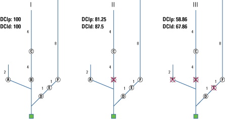
An example connectivity analysis from the Fish Passage Extension tool in ArcMap showing three scenarios of culvert placement with associated potamodromous Dendritic Connectivity Index (DCIp) and diadromous Dendritic Connectivity Index (DCId) values. The green box represents the “sink,” or the location farthest downstream in the watershed being analyzed. Circled letters (A–F) represent possible barrier locations. Permeabilities were set to 0.5 for all barriers in this example. Numbers adjacent to stream segments represent relative segment length on a scale of 1 to 8. Scenario I shows a fully connected watershed with no barriers to connectivity. Scenario II shows the same watershed with the addition of a single barrier (the barrier, with permeability 0.5, is indicated by an X over the letter “B”). Scenario III shows the same watershed, but this time highly fragmented with three barriers (with permeabilities 0.5, indicated by X’s over the letters “A,” “B,” and “E”).
References Cited
Cote, D., Kehler, D.G., Bourne, C., and Wiersma, Y.F., 2009, A new measure of longitudinal connectivity for stream networks: Landscape Ecology, v. 24, no. 1, p. 101–113, accessed October 11, 2022, at https://doi.org/10.1007/s10980-008-9283-y.
Oldford, G., Cote, D., Wiersma, Y.F., Kehler, D.G., and Riefesel, G.R., 2022, Fipex+Dci V10.4—Bridging network analysis and GIS for river connectivity assessment: SSRN, research paper 4159582, preprint posted July 11, 2022, 15 p., accessed November 2, 2022, at https://doi.org/10.2139/ssrn.4159582.
Appendix 3. “dci” R Package Sample Script
Reference Cited
Arkilanian, A., 2023, dci—Calculate the Dendritic Connectivity in river networks, R package version 0.0.0.9000: GitHub software release, accessed June 1, 2023, at https://github.com/aarkilanian/dci.
Species Names
Common name Scientific name
bluehead sucker
Pantosteus discobolus (referred to as Catostomus discobolus in Compton and others, 2008)
brook trout
Salvelinus fontinalis
Chinook salmon
Oncorhynchus tshawytscha
coho salmon
Oncorhynchus kisutch
flannelmouth sucker
Catostomus latipinnis
leopard darter
Percina pantherina
roundtail chub
Gila robusta
Publishing support provided by the Science Publishing Network,
Denver Publishing Service Center
For more information concerning the research in this report, contact the
Center Director, USGS Fort Collins Science Center
2150 Centre Ave., Bldg. C
Fort Collins, CO 80526-8118
(970) 226-9100
Or visit the Fort Collins Science Center website at:
Disclaimers
Any use of trade, firm, or product names is for descriptive purposes only and does not imply endorsement by the U.S. Government.
Although this information product, for the most part, is in the public domain, it also may contain copyrighted materials as noted in the text. Permission to reproduce copyrighted items must be secured from the copyright owner.
Suggested Citation
Lehrter, R.J., Rutherford, T.K., Dunham, J.B., Johnston, A.N., Wood, D.J.A., Haby, T.S., and Carter, S.K., 2024, Effects of culverts on habitat connectivity in streams—A science synthesis to inform National Environmental Policy Act analyses: U.S. Geological Survey Scientific Investigations Report 2023–5132, 21 p., https://doi.org/10.3133/sir20235132.
ISSN: 2328-0328 (online)
| Publication type | Report |
|---|---|
| Publication Subtype | USGS Numbered Series |
| Title | Effects of culverts on habitat connectivity in streams—A science synthesis to inform National Environmental Policy Act analyses |
| Series title | Scientific Investigations Report |
| Series number | 2023-5132 |
| DOI | 10.3133/sir20235132 |
| Publication Date | February 07, 2024 |
| Year Published | 2024 |
| Language | English |
| Publisher | U.S. Geological Survey |
| Publisher location | Reston VA |
| Contributing office(s) | Fort Collins Science Center, Northern Rocky Mountain Science Center |
| Description | vii, 16 p. |
| Online Only (Y/N) | Y |