

Desert Tortoise Translocation Plan for the U.S. Department of the Army National Training Center and Fort Irwin Western Training Area
Links
- Document: Report (15 MB pdf) , HTML , XML
- Data Release: USGS Data Release - Terrestrial Development Index for the western United States—1-kilometer moving window
- NGMDB Index Page: National Geologic Map Database Index Page (html)
- Download citation as: RIS | Dublin Core
Acknowledgments
Logistical and administrative support and funding were provided by Muhammad Bari, Penn Craig, David Davis, David Housman, Derrick Pace, and Christopher Woodruff with the Directorate of Public Works, U.S. Department of the Army National Training Center Fort Irwin. We thank Dawn Nahhas and Donna Knifong with the U.S. Geological Survey Science Publishing Network for editing this manuscript, figures and tables of this report. Discussions, guidance, and support were also provided by Keith Miles, Diane Elam, and Amy Vandergast (U.S. Geological Survey); Kristina Drake, Roy Averill-Murray, Kim Field, Linda Allison, Brian Croft, and Scott Hoffmann (U.S. Fish and Wildlife Service); Jeff Childers, Chris Otahal, Mark Masser, and Katrina Symons (Bureau of Land Management); and Laura Patterson, Ali Aghili, and Eric Negrete (California Department of Fish and Wildlife).
Project management and fieldwork were done by many individuals with the U.S. Geological Survey Western Ecological Research Center, including Ashley Alardi, Susan Bard, Graham BeVier, Marscilla Bueno, Evan Cedrone, Jack Christie, Natalie Cibel, Mara Cobb, Meghan Connelly, Brent Cunningham, Kathryn Davison, Alex Fortin, Jeremy Fuller, Chase Green, Michaela Grubb, Angela Guglielmino, Alison Haigh, Esther Hwang, Marianne Kelso, Garrett Lawson, Isabel Marzullo, Jake McArtor, Brittany McGill, Mary Meyerpeter, Erin Netoskie, César Ortiz, Margaret Pasanen, Nathan Quatier, Caleigh Quick, Emma Rose Parker, Margaret Pasanen, Amanda Rohr, Stephanie Ruck, Leticia Santillana-Fernandez, Erika Sertl, Eric Simandle, Cory Snyder, Arin Thacker, Randolph Thomas, Janne Torres Jarin, Hansen Tsai, Catherine Werth, Drew White-Jacobson, Chad Wilhite, Ally Xiong, and Nathaniel Yost.
Assistance with data management and fieldwork was provided by Ironwood Consulting staff, including Chris Blandford, Danna Hinderle, Shannon Hoss, Rachel Woodard, Steve Ishii, Matt Adams, Tim Alvey, Sarah Baden, Mary Baker Toelkes, Mike Bassett, Nathan Banfield, Kelsi Black, Samantha Burrell, Corey Chan, Sage Clegg, Sadie DeCurtis, Adam Drummer, Karin Edwards, Kristin Hayes, Kelly Herbinson, Kristen Koeper, Nathan Labieniec, Marina Lavender, Audrey Layden, Maribel Lopez, Wendy McBride, Colden McClurg, Zachary Meeks, Corey Mitchell, Jake Mohlmann, Gerald Monks, Mike Moon, Chad Moura, Scott Nelson, Sam Nielson, Hattie Oswald, Abraham Role, Mike Sally, Brian Sandstrom, Crissy Slaughter, Jason St. Pierre, Travis Toelkes, Zachery Webb, Mandy Wegmann, and John Yerger.
Abstract
The U.S. Department of the Army proposes to commence military activity at the Fort Irwin National Training Center within the Western Training Area (WTA) and to translocate Mojave Desert tortoises (Gopherus agassizii; hereafter tortoise) that will be affected to the Western Training Area Translocation Site (WTATS). This desert tortoise translocation plan provides a timeline of activities, actions for which permits may be required, and guidelines for assessing the short-term and long-term success of this desert tortoise translocation. Importantly, the monitoring projects described are designed to document the ultimate effects of the Army's translocation action (not just inform future translocations elsewhere). Results from the translocation, corresponding monitoring, and research projects will inform future translocations throughout the Mojave Desert for expanding human development. The plan has three main objectives: (1) provide guidelines to achieve a safe, humane, and successful translocation of tortoises from the WTA, with minimal effect to resident desert tortoises at sites where translocated animals are released (recipient sites); (2) study translocated, resident, and reference animals (tortoises living near translocation areas but whose home ranges do not overlap those of translocated or resident tortoises) to learn as much as possible about the ecology, conservation, and management of the desert tortoise; and (3) define best management practices for successful translocation and provide metrics to evaluate success over multiple time scales, which we identify for the short- and long-term.
The procedures to plan, implement, monitor, and study translocation of tortoises were written using terms and conditions outlined in the U.S. Fish and Wildlife Service Biological Opinion 2021 that described effects of the expansion of the military base boundary, as well as recommendations provided in the Desert Tortoise Recovery Plan (and 5-year review). We provide guidance on appropriate translocation timing and procedures, as well as on how tortoise ecology and habitat can best be studied to further knowledge on tortoise translocation. The plan provides analysis for landscape tortoise density and abundance estimates, suitable sites for translocation of tortoises, and short- and long-term metrics that are addressed and measured by specific monitoring and research projects that can be used to assess the success of translocation activities.
Introduction
The U.S. Department of the Army (Army) plans to commence military activity and training exercises within the National Training Center (NTC) and the Fort Irwin Western Training Area (WTA) in San Bernardino County, California. If approved, the NTC will establish training areas to test the combat readiness of brigade-sized units (1,000–5,000 soldiers and 1,000–1,500 vehicles) in a realistic battlefield environment. Starting in 2025 (app. 1), as many as 10 brigade-level training events may happen with force-on-force and live-fire scenarios to prepare units for combat and security missions. In addition to Army units stationed at Fort Irwin, joint military branches (Marine Corps, Navy, and Air Force), Army Reserve, National Guard, Special Operations Forces, multinational partnerships, and regular and transitional law enforcement units also train at the NTC. Planned actions in the WTA would likely change land use patterns in areas that were previously undisturbed and affect desert tortoises and their habitats such that translocation of the federally and California State listed Mojave Desert tortoises (Gopherus agassizii; hereafter tortoise) would be required by the U.S. Fish and Wildlife Service (USFWS) before training ensues to minimize tortoise mortality (U.S. Fish and Wildlife Service, 1994, 2011, 2020, 2022b). Minimization of land used for military activities in the WTA will be considered throughout the translocation process. This study was done in cooperation with the U.S. Department of Defense, U.S. Army Garrison Fort Irwin, California, and U.S. Geological Survey.
The Army’s plan for military activities in the WTA follows previously completed actions from the Fort Irwin Military Land Withdrawal Act of 2001 (Congress Public Law 107-107, div. B, title XXIX, December 28, 2001, 115 United States Statues at Large 1336), authorizing the NTC to expand its training activities into approximately 577 km2 of military lands previously designated as “critical habitat for tortoises” (U.S. Fish and Wildlife Service, 2011). These lands included NTC expansion areas that had enough tortoises to warrant translocation, the Southern Expansion Area (SEA), and the Superior Valley (referred to as “Western Expansion Area,” or “WEA,” during the 2005 translocation; now referenced as the Western Training Area; 285.6 km2). To prepare for the NTC’s first large-scale tortoise translocation in 2005, available information documenting tortoise translocation was used to formulate the NTC translocation plan and support translocation as an adequate solution for successful relocation of displaced tortoises. Much of the available information focused on several short-term translocation success metrics (movement patterns and survivorship), with further investigation required to evaluate the effects of translocation at several temporal scales to evaluate long-term (15–30 years) success given the long lifespan of desert tortoises (Tasse, 1989; Dickinson and Fa, 2000; Fischer and Lindenmayer, 2000; U.S. Fish and Wildlife Service, 2020). Desert tortoises generally are sexually mature when they reach greater than 180 millimeters (mm) in carapace length (Turner and others, 1986, 1987). The time it takes for tortoises to reach this size ranges between 15 and 21 years, depending on environmental conditions and other habitat characteristics that affect resource availability during their development (Turner and others, 1987; Tracy and Tracy, 1995; Medica and others, 2012). Long-term monitoring (25 years) is implemented to fully understand the success of translocation.
Previous plans for the translocation of tortoises from NTC expansion areas (Esque and others, 2005, 2009) sought to fill gaps in translocation knowledge, documented actions, and procedures to: (1) provide safe, humane, and successful translocation of tortoises with minimal effect to resident (animals living within the recipient sites before translocation) and reference (telemetered animals living outside of the translocation sites, but whose movements are predicted not to overlap with translocated or resident animals) tortoises at sites where translocated animals are released; (2) study tortoises affected by translocation to increase understanding of the ecology, conservation, and management of desert tortoises (U.S. Fish and Wildlife Service, 1994, 2011, 2022b; Tracy and others, 2004); and (3) define measures of success for translocation and provide metrics to evaluate success during multiple time scales.
There were large-scale translocations of approximately 650 adult tortoises from the Southern Expansion Area (SEA) at the NTC to public lands just to the south (the Southern Expansion Translocation Area) in 2008. The NTC’s 2005 Translocation Plan described conservation science activities sponsored by the NTC to be enacted during the next approximately 20 years (Esque and others, 2005). In 2011, all conservation science activities supported by the NTC for tortoises associated with the SEA and WEA (now WTA) as described in the 2005 and 2009 Translocation Plans were discontinued prior to completing the WEA translocation (Esque and others, 2005; Esque and others, 2009); however, extramural funding from the National Science Foundation supported limited activities for approximately 4 years and provided some post-translocation short-term information (table 1). The NTC translocations were followed by additional translocations for planned military training activities in the region (such as Marine Corps Air Ground Combat Center, 2016; U.S. Fish and Wildlife Service, 2017).
Table 1.
List of citations that describe general topics and research activities of Mojave Desert tortoises, tortoise habitat, and tortoise translocation activities supported by the National Training Center, Fort Irwin, California.[>, greater than; km, kilometer; km2, square kilometer]
| Citation | General topic(s) | Research activities |
|---|---|---|
| Aiello and others, 2014 | Disease | Disease dynamics between translocated tortoises and resident tortoises and infection outbreak likelihood based on tortoise population dispersal, susceptibility, size, and connectivity. |
| Aiello and others, 2018 | Disease | Identification of transmission patterns associated with mating strategies, burrow use, and seasonal behaviors of wild and captive desert tortoises. |
| Allison and McLuckie, 2018 | Adult density trends | Line-distance sampling for estimating annual adult densities in Mojave Desert federally designated Tortoise Conservation Areas (TCAs). |
| Andersen and others, 2000 | Habitat modelling | Creation of a statistical GIS-based desert tortoise habitat model using survey field data and data from available spatial databases. |
| Averill-Murray and Allison, 2023 | Road density | Decline of tortoise populations within conservation areas where road densities were >0.75 km/km2 and consequential recommendations for managing conservation areas. |
| Aycrigg and others, 1998 | Habitat modelling | Assessing the impacts of military training at the NTC Fort Irwin on desert tortoises and their habitat; a model was developed to provide land managers with a tool that would predict tortoise population trends based on land use. |
| Aycrigg and others, 2004 | Habitat modelling | Spatially dynamic tortoise habitat modelling to assess impacts of military training. |
| Baxter and others, 2008 | Reproduction | Monitoring nest placement of wild and captive female tortoises to study effects on hatchling sex ratio and survival at the Fort Irwin Study Site (FISS). |
| Berry, 2002 | Physical growth | Measuring growth rings of costal scutes on tortoises while comparing growth to years of precipitation and forage biomass availability. |
| Berry and others, 2006 | Anthropogenic threats | Tortoise density variability in proximity to anthropogenic sources (for example, surface disturbance, paved roads, trash, military ordnances). |
| Berry and others, 2015 | Disease | Using health evaluation and testing for the prevalence and spatial distribution of Mycoplasma pathogens to understand habitat variables that affect tortoise health. |
| Bowen and others, 2015 | Genetics, disease, stress | Development of a leukocyte gene transcription biomarker panel to assess physiological health and stress of tortoises within specific environmental conditions. |
| Carter and others, 2020 | Habitat modelling, anthropogenic threats | Using habitat modelling to evaluate efficacy of desert tortoise habitat protections at national, state, and local levels when quantifying human development. |
| Cypher and others, 2018 | Predation | Observation of coyote (Canis latrans) diet patterns and preference. |
| Doak and others, 1994 | Demographics | Demographic analyses/Population Viability Analysis (PVA) conducted on Western Mojave tortoises to model survival and population growth for desert tortoises. |
| Drake and others, 2012 | Stress | Physiological stress associated with tortoise translocation. |
| Emblidge and others, 2015 | Predation | Observation of localized tortoise predation and patterns linked to American badgers (Taxidea taxus). |
| Esque and others, 2005 | Translocation plan | NTC Ft. Irwin’s land expansion program tortoise translocation plan for translocation of tortoises from the Southern Expansion Area (SEA). |
| Esque and others, 2009 | Translocation plan | Amendment to NTC Fort Irwin’s land expansion program tortoise translocation plan (2005) for translocation of tortoises from the Western Expansion Area (WEA). |
| Esque and others, 2010 | Predation | Predation of translocated tortoises in comparison to resident and control tortoises and overall range-wide patterns, with respect to drought considerations. |
| Franks and others, 2011 | Home ranges | Home range size comparisons between adult male and female tortoises among areas with varying precipitation. |
| Harless and others, 2010 | Home ranges | Tortoise home range size estimation using two compared statistical estimators and field sampling. |
| Hazard and Morafka, 2002 | Movement patterns | Observation of movement patterns of previously captive neonate and juvenile tortoises released to the Fort Irwin Study Site. |
| Heaton and others, 2008a | Surveys | Using wildlife-detector dog and human surveying teams to compare if either team increased risks or types of predation on desert tortoises. |
| Heaton and others, 2008b | Habitat modelling | Development of a spatially explicit decision support system model to identify potential suitable translocation areas for tortoises incorporating biological, anthropogenic, and logistic criteria. |
| Hinderle and others, 2015 | Site fidelity and dispersal | Dispersal, homing, and overall movement of translocated tortoises subject to three distance treatments. |
| Jacobson and Berry, 2009 | Disease | Presence of oxalate crystals within renal system of tortoises. |
| Jacobson and others, 2012 | Disease | Research review and updates on Upper Respiratory Tract Disease (URTD) and its causative agents (Mycoplasma agassizii and Mycoplasma testudineum) in tortoises. |
| Johnson and others, 2005 | Disease | Genetic sequencing of Testudinid herpesvirus 2 (TeHV2) for the first-time using information from an adult female captive tortoise exhibiting anorexia, lethargy, and mouth lesions consistent with previous reports of tortoise herpesvirus. |
| Johnson and others, 2006 | Disease | ELISA testing used to detect antibodies for and identify clinical signs of disease associated with Mycoplasma agassizii and tortoise herpesvirus, with exposure to Mycoplasma found to be higher in captive tortoises than in wild tortoises. |
| Karl, 2002 | Demographics | Tortoise density estimates at NTC Fort Irwin expansion areas using survey data. |
| Kissel and others, 2023 | Occupancy | Predicting range-wide occupancy, colonization, and local extinction rates of tortoises using data from the long-term USFWS line distance sampling program. |
| Krzysik, 1994 | Management | Assessment and monitoring report of surrounding habitat, biological and environmental parameters that affect tortoise distribution and density, and management and research implications at NTC Fort Irwin. |
| Latch and others, 2011 | Genetics | Identification of factors with greatest influence on genetic variation within tortoise populations at local scales. |
| Mack and others, 2015 | Site fidelity, cover sites | Cover site use with varying structural characteristics. |
| Mack and Berry, 2023 | Site fidelity, dispersal, survival | Review of NTC Fort Irwin Southern Expansion Area (SEA) tortoise translocation. |
| McIntyre and others, 2010 | Predation | Identifying common raven (Corvus corax) threats to tortoises in the SETA translocation area based on raven density surveys. |
| Mulder and others, 2017 | Genetics, recruitment | Male genetic integration into translocation area populations by testing genetic paternity of hatchlings from translocated and resident female tortoises. |
| Nagy and others, 2015a | Head-starting, side fidelity, dispersal, survival | Releasing head-started juvenile tortoises under different conditions to assess the effects of release distance, release season, and age and body size on homing behavior and survivorship. |
| Nussear and others, 2008 | Surveys | Comparative surveys to determine whether human or detector dog teams were more effective at detecting desert tortoises in the wild. |
| Oftedal and others, 2002 | Diet | Annual vegetation biomass, nutritional quality, and forage selection by captive tortoises held at NTC Fort Irwin. |
| Sah and others, 2016 | Cover sites | Refuge (burrow) use variability by translocated and resident tortoises relative to season, burrow age, and topographic location of burrow. |
| Spangenberg, 1996 | Field enclosures | Use of tortoise enclosures to obtain data on the life history of neonate and juvenile tortoises and evaluate enclosure use as a conservation tool. |
| Spotila and Avery, 2002 | Land use | Lessons from the expansion of the National Training Center at Fort Irwin. |
| Walde and others, 2007 | Anthropogenic threats | Threats of human garbage and litter particularly resistant to degradation (for example, balloons) to tortoises. |
| Westervelt and others, 1997 | Land use | Development of a dynamic simulation model to manage and protect the desert tortoises at NTC Fort Irwin; model creates multiple land use scenarios and predicts their consequences and severity on natural and human environments. |
| Woodman and others, 1986 | Density, distribution | Report of the estimated density and distribution of desert tortoises at NTC Fort Irwin and Goldstone Space Communications Complex. |
| Zylstra and others, 2023 | Density | Development of a hierarchical distance sampling model that accounts for ecological and observational processes and predicts potential spatial variation in tortoise densities. |
Research and monitoring of tortoises, habitats, and translocation activities that were done in association with the 2008 NTC translocation substantially contributed to knowledge of tortoise ecology, regional landscape conditions, and related effects of translocation, with numerous studies supported financially and logistically by the NTC (table 1). Various surveying and analytical methods used to detect tortoise presence have informed regional tortoise density estimates, population trends, and habitat models used to predict potential areas of tortoise habitat (Karl, 2002; Aycrigg and others, 2004; Berry and others, 2006; Heaton and others, 2008a, 2008b; Nussear and others, 2008, 2009; Harless and others, 2010; Allison and McLuckie, 2018; Carter and others, 2020; Parandhaman and others, 2022; Averill-Murray and Allison, 2023; Kissel and others, 2023; Zylstra and others, 2023). Identification, assessment, and protection of suitable tortoise habitat has become critical to tortoise conservation because enduring tortoise population declines have been documented in four of five federally designated Mojave Desert recovery units (Allison and McLuckie, 2018; Zylstra and others, 2023). Human development and habitat fragmentation have contributed to tortoise population declines and affected the demographic viability of tortoise populations vital to the survival of the species (Averill-Murray and Hagerty, 2014; Allison and McLuckie, 2018; Carter and others, 2020; Hromada and others, 2020; Averill-Murray and others, 2021; Averill-Murray and Allison, 2023). One aspect of supporting demographically viable tortoise populations is identifying tortoise genetic units on the landscape to allow evaluations of the costs and benefits to genetic diversity, which can be a driver of healthy tortoise populations when moving tortoises among sites (Averill-Murray and Hagerty, 2014; Scott and others, 2020). Initial genetic integration of translocated tortoises into release areas was low when paternity of young tortoises was analyzed based on genetics (Mulder and others, 2017); however, further longer-term reproductive investigation is needed.
During and after the 2008 NTC SEA translocation, research was done to better understand movement and space use (through habitat and among burrows), disease transmission risks, stress levels, and gene flow after translocation (Latch and others, 2011; Drake and others, 2012; Aiello and others, 2014, 2018; Averill-Murray and Hagerty, 2014; Bowen and others, 2015; Farnsworth and others, 2015; Sah and others, 2016; Mulder and others, 2017; Mack and Berry, 2023). The stress response of translocated tortoises was assessed by quantifying and comparing values of the reptilian hormone corticosterone for translocated, resident, and reference tortoises. Results indicated that translocation did not elicit a detectable physiological stress response from tortoises but rather patterns varied by sex, activity season, and year (Drake and others, 2012). Additional post-translocation studies corroborated findings on space-use and site fidelity from previous years, in which translocated tortoises dispersed greater distances (1.5 times more than reference tortoises) and had lower site fidelity in the first year after translocation when compared to resident and reference populations (Hinderle and others, 2015). Translocated tortoises are likely to disperse shorter distances and have a higher likelihood of survival when the recipient sites have an abundance of tortoise burrows, a variety of soil substrate textures that provide opportunities for burrow construction, and plentiful washes on the landscape for travel corridors and foraging, although translocated tortoises generally visit fewer burrows than resident tortoises (Mack and others, 2015; Sah and others, 2016; Nafus and others, 2017a). Threats to desert tortoises, including proximity to urban areas and predation by mammalian carnivores, were documented after the 2008 SEA translocation; however, these threats were not unique to the NTC or translocation activities and instead were documented throughout the Mojave Desert in relation to prolonged drought conditions and subsidized predators in proximity to urbanized areas (Esque and others, 2010; Cypher and others, 2018; Emblidge and others, 2015). Other documented threats included roads, litter, climate, and ravens (Corvus corax; Walde and others, 2007; McIntyre and others, 2010; Mack and Berry, 2023). Tortoise disease, particularly Upper Respiratory Tract Disease (URTD) and Testudinid herpesvirus 2 (TeHV2), has been further chronicled, with the pathogenicity of suspected causative agents Mycoplasma agassizii and Mycoplasma testudineum confirmed, refined antibody and pathogen presence laboratory tests developed, and transmission patterns in captive and wild populations studied (Jacobson and others, 2012; Aiello and others, 2014, 2018; Berry and others, 2015).
Desert Tortoise Translocation Goals
This translocation plan is designed to monitor metrics that are correlates of desert tortoise fitness and can be used as thresholds for decision-making. Methods to evaluate the success of this translocation and to enhance knowledge of desert tortoise translocations (described later) include short- and long-term monitoring metrics involving future surveys in areas where there were translocations to evaluate the status of translocated, resident, and reference tortoise populations at several time scales (Berry, 1986; Dodd and Seigel, 1991; Nussear and others, 2012). This plan includes recent (April 2020–November 2022) results of baseline biological investigations pertaining to tortoises in the WTA and surrounding habitats, including the Western Training Area Translocation Site (WTATS) and the release areas (recipient sites) for translocated tortoises. Resident and reference tortoises in the WTATS have been monitored since spring 2020. Monitoring efforts are designed to achieve the goals of (1) measuring translocation success and fitness of tortoises in all study groups, (2) assessing the assimilation of translocated tortoises into the recipient population, and (3) enhancing the understanding of resource requirements to assist in future translocations and tortoise conservation management.
The plan builds on previous translocation endeavors while addressing clearance, translocation, monitoring methods, and expected results of translocation implementation for associated tortoises. This information is intended to help maximize individual survival and promote regional recovery efforts for tortoises when possible. The methods described are consistent with the recommendations and guidance from the USFWS (original and revised Mojave Desert tortoise recovery plans; U.S. Fish and Wildlife Service, 1994, 2011) and Translocation Plan Development Guidance document (U.S. Fish and Wildlife Service, 2020), Bureau of Land Management (BLM), and California Department of Fish and Wildlife (CDFW). Details of the proposed WTA military activities, potential effects, and terms and conditions can be found in the U.S. Fish and Wildlife Service Biological Opinion 2021 (U.S. Fish and Wildlife Service, 2021a) for the Recovery and Sustainment Partnership Initiative, Use of Additional Maneuver Training Lands, and Operations and Activities at the National Training Center and Fort Irwin, San Bernardino County, California (USFWS-SB-20F0163-21F1366, December 13, 2021) and the Project Timeline (app. 1).
Project Area: Site Descriptions
Western Training Area
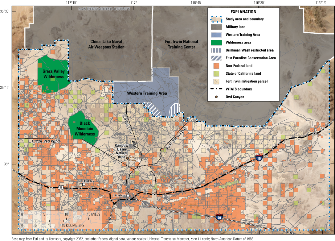
The WTA (286 km2) is in the southwest corner of the Fort Irwin NTC (fig. 1). The WTA is bounded by the geographical designations of 3908200 and 3890200 northing and 492500 and 516500 easting Universal Transverse Mercator (UTM) lines. The WTA borders the Naval Air Weapons Station-China Lake (3908200 northing UTM; 492500 easting UTM) to the north, the Paradise Range and Lane Mountain to the south, and Superior Dry Lake to the west. The WTA is comprised of broad flat valleys with many sandy washes interspersed by low gentle hills and rocky outcrops (northwest corner of the WTA). Most of the area is internally drained by the Superior and Goldstone Basins. The elevation within the WTA ranges from 814 to 1,382 meters (m).
Expansion planning for the U.S. Army National Training Center activities into the Fort Irwin Western Training Area (WTA) that will result in the displacement of wild desert tortoises that reside in the WTA, as of 2024, into the Western Training Area Translocation Site (WTATS).
The WTA includes two contiguous areas of restricted access that are not considered further in this translocation plan. Excluding the conservation or restricted access areas, the WTA encompasses 254 km2 (fig. 1). The first restricted access area is known as the “East Paradise Conservation Area” that is 18 km2 and was designated as a “BLM Area of Critical Environmental Concern” (Bureau of Land Management, 2005) for the conservation of the Mojave Desert tortoise, endemic Lane Mountain milkvetch (Astragalus jaegerianus), and the Mojave ground squirrel (Xerospermophilus mohavensis). The East Paradise Conservation Area is fenced with tortoise exclusionary fencing to the northeast, allowing tortoises from the southwest to access this area but not the rest of the WTA. The second restricted access area, Brinkman Wash Restricted Area, was designated by the Army for foot traffic only and is 14 km2.
Western Training Area Translocation Site
The WTATS was delineated through discussions among the BLM, NTC, U.S. Geological Survey (USGS), and USFWS by reviewing suitable translocation sites for tortoises and using subsequent analyses by USGS (see the “Modeling Habitat Site Selection for Recipient and Reference Sites” section). We evaluated approximately 5,585 km2 of lands, mostly west, south, and southeast of the WTA in San Bernardino County, California (fig. 1). During our evaluation, we reduced the footprint of this larger landscape (used and referenced as the study area) to include habitats most appropriate for translocated tortoises, which is now referred to as the “WTATS” (fig. 1). The WTATS covers approximately 3,296 km2 of mostly public lands north of Barstow and Hinkley, California, and is bounded on the north by the Naval Air Weapons Station China Lake (3917952 and 3849256 northing UTM lines), to the south by the 3849332 northing UTM line, to the east by the 458197 easting UTM lines, and to the west by 571068 easting UTM line within the Soda Mountains. The eastern side of the WTATS incorporates habitats where NTC previously translocated tortoises from its SEA (Esque and others, 2005) in 2008. The WTATS includes two BLM designated Wilderness Areas: (1) Grass Valley and (2) Black Mountain, and there are two recreation areas and public campgrounds at Rainbow Basin and Owl Canyon, which collectively comprise 210 km2 (fig. 1). The WTATS is a mosaic of property ownership and management, with public lands managed by the BLM, which administers the greatest amount of land (approximately 2,145 km2; 65 percent; fig. 1) and oversees a large network of roads and trails (including off-highway vehicles [OHVs]) in the region. Holdings by the NTC (referred to as “Fort Irwin mitigation parcels” or “Irwin mitigation parcels” that are 2.59 km2; approximately 320 km2; 9.7 percent), the State of California lands (approximately 93 km2; 2.8 percent), and non-Federal or private property (approximately 742 km2; 22.5 percent) represent the remaining ownership and are largely concentrated in the southern WTATS (fig. 1). The WTATS is more topographically diverse than the WTA and comprised of large broad valleys, rugged volcanic and granitic mountains, and gentle hills made up of diverse sedimentary parent materials. The region encompasses a large network of washes that drain into the Superior and Harper Valley Basins and associated dry lakes. The elevation in this area ranges from 516 to 1,250 m.
Site Selection Guidance from the Bureau of Land Management
Due to a complex network of property ownership, management, and landscape use throughout the West Mojave management area, staff at BLM Barstow and Ridgecrest Field Offices provided recommendations for habitats and areas that should be excluded from consideration as potential recipient sites within the WTATS study area. These recommended avoidance areas included (1) areas south of Interstate 15 (I–15), Interstate 40 (I–40), and State Route 58, (2) areas east and south of a primary transmission utility corridor and access road, (3) BLM designated wilderness (Grass Valley and Black Mountain wildernesses), and (4) targeted areas south and southwest of Fossil Bed Road that have highly intense recreation activities and other landscape concerns (fig. 2). In later discussions, the BLM indicated that any translocated tortoises that moved into designated Wilderness Area habitats from their recipient sites would not be removed by the BLM; however, such a scenario is unlikely because proposed recipient sites, and their calculated dispersal range buffers (6.5 kilometers [km]; U.S. Fish and Wildlife Service, 2020), are not expected to extend into Wilderness Areas and are separated from Wilderness Areas by natural geographic barriers. The BLM Barstow Field Office also provided information regarding where BLM and their partners are focusing route restoration efforts (areas between and east of the Wilderness Areas), including the suggestion that these areas receive higher priority as recipient sites due to in-progress and anticipated improvements in habitat conditions.
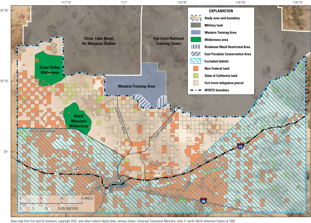
Revised project area map that shows areas excluded from translocation consideration (excluded habitats) based on recommendations from the Bureau of Land Management (BLM) that are consistent with property ownership and landscape use in the region.
Baseline Tortoise Investigations (2020–22)
We performed baseline tortoise and habitat investigations in the WTA and the WTATS after the boundaries and habitat considerations were identified. All baseline activities pertaining to tortoises and their habitats were authorized under a USFWS Federal permit (number TE-63428D-0, -1), a CDFW Memorandum of Understanding (MOU; signed “March 30, 2020”), and a BLM MOU (signed “March 31, 2020”). A subset of tortoises located during the tortoise surveys (described in the next section) had radio transmitters attached to locate them during further investigations (telemetered tortoises). General methods and handling protocols done from April 2020 to November 2022 were approved by the USGS-Western Ecological Research Center Animal Care and Use Committee (U.S. Geological Survey, 2020). Tortoise surveys were done using tortoise surveying, capturing, handling, monitoring methods, and applications as described in the “Tortoise Clearance Protocols for the Western Training Area” section of this plan.
Tortoise Survey Plots
Proposed training areas (in the WTA) and recipient sites (in the WTATS) were surveyed to estimate tortoise density and abundance and to document habitat characteristics. Survey plots (300 by 300 m) were randomly distributed on public lands for tortoise surveys during spring and fall 2020, 2021, and 2022 by following protocols similar to USFWS (2022a; fig. 3). All tortoise sign was recorded, including live tortoises (tortoises greater than 180-mm carapace length [hereafter adults] and tortoises less than or equal to 180-mm carapace length [hereafter juveniles]), carcasses, and burrows. Plots were at least 50 m from BLM designated roads and excluded from non-federally owned parcels, campgrounds, dry lake beds (when possible), and designated Wilderness Areas. Survey transects were spaced at 10-m intervals beginning in the southwestern corner of each plot. A total of 1,408 plots were surveyed in the project area from spring 2020 to spring 2022.
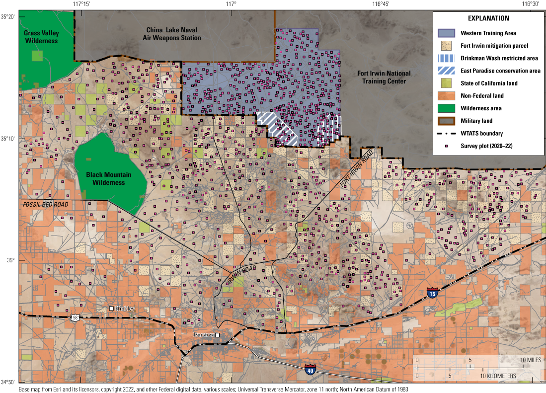
Survey plots in the National Training Center (NTC) Western Training Area and adjacent public lands (Western Training Area Translocation Site [WTATS]) from spring 2020 to spring 2022.
Baseline Tortoise Health Assessments
The 2020–22 plot surveys (fig. 3) and monitoring efforts for telemetered tortoises throughout the project area included observations of 783 tortoises, 41 of which were from the 2008 NTC translocation efforts (fig. 4). Of the tortoises observed, 86 percent were adult tortoises, with a consistent two male to one female sex ratio among years. Most tortoise encounters were when tortoises were in burrows or under vegetation. The most frequently used vegetative cover species throughout the study area were Larrea tridentata (creosote bush), Ambrosia dumosa (burro bush), and Atriplex polycarpa (desert saltbush).
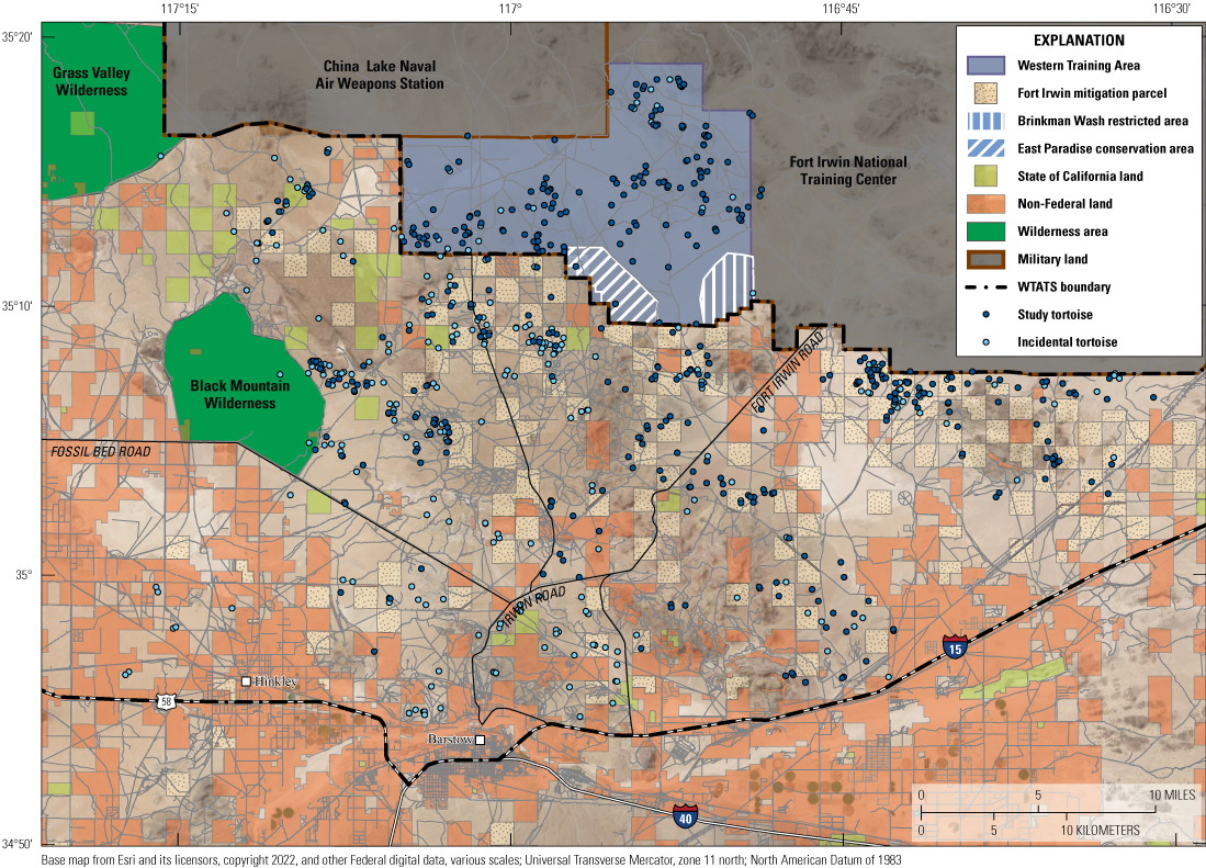
Land ownership status during 2020–22 to provide updated information on the presence and distribution of tortoises included in the study and tortoises found incidentally within study area.
From 2020 to 2021, in the WTATS and WTA, telemetered tortoises were evaluated for clinical health conditions with physical assessments, including body condition scoring (BCS) and tissue collection (blood samples and oral swabs) whenever possible, following USFWS guidance (U.S. Fish and Wildlife Service, 2019). Clinical health conditions of tortoises were characterized by examining each animals posture, respiration, face (with specific attention to the eyes, periocular tissue, nares, mouth, tongue, and oral mucosa), skin, and shell for signs of disease, abnormalities, damage, or discoloration. Health assessors also searched for any discharge from the cloaca, eyes, nares, and mouth or evidence of ulceration, erythema, swelling, or discharge on the skin (U.S. Fish and Wildlife Service, 2019). The overall condition and fat stores with respect to skeletal features of the head and limbs of animals were characterized through assignment of numerical body condition scores, first through categorization as “under,” “adequate,” or “over” condition, and then by numerical values (under: 1–3, adequate: 4–6, over: 7–9) to provide a precise and repeatable measurement (U.S. Fish and Wildlife Service, 2019). Ectoparasites observed on tortoises (including Ornithodoros spp. [ticks]) were counted, placed in cryogenic vials, and stored on wet ice while in the field and later flash frozen with dry ice or placed directly into ultracold storage (−70 degrees Celsius [°C]).
Immediately after the physical assessment, tissues were collected from each animal (when possible, including blood and oral swabs). Whole blood was extracted (0.3–2.0 milliliters [mL] separated into aliquot samples, when appropriate) via subcarapacial venipuncture (Hernandez-Divers and others, 2002) using a 3.81 centimeter (cm), 23-gauge needle, and 3-mL syringe coated in sodium heparin to prevent coagulation. Whole blood was either placed directly onto a Whatman FTA card (GE Healthcare Life Science, Marlborough, Massachusetts; less than 0.01-mL blood), or into a cryogenic vial with Invitrogen RNAlater (ThermoFisher Scientific, Vilnius, Lithuania) mixed at 2 parts solution to 1 part blood for future ribonucleic acid (RNA) extraction and gene expression analysis or into a BD Microtainer tube with lithium heparin (Becton Dickinson and Company, Franklin Lakes, New Jersey) for subsequent centrifugation to separate plasma. Sloughed epithelial cells from mouths of tortoises were collected using oral swabs that were rotated slowly across surfaces of the tongue and oral mucosa. All samples were stored on wet ice for no more than 4 hours and then transferred to an ultracold freezer (−70 °C). Blood plasma and oral swab samples were sent to labs for enzyme-linked immunosorbent assay (ELISA) testing for acquired antibodies and quantitative polymerase chain reaction (qPCR) testing for pathogen presence of Mycoplasma agassizii (Myag) or Mycoplasma testudineum (Myte)—both causative agents of URTD in desert tortoises—and TeHV2 (Origgi and others, 2002; Johnson and others, 2005; Wendland and others, 2007; Jacobson and others, 2012; Burgess and others, 2021). ELISA lab results were reported as negative (antibody titer less than 32), suspect (antibody titer greater than or equal to 32 and less than 64), or positive (antibody titer greater than or equal to 64), whereas qPCR lab results were reported as negative, positive, or equivocal (inconclusive) based on cycle threshold values.
Health assessments were done on 393 telemetered tortoises throughout the NTC project area during 2020–22. Most tortoises examined were classified as “clinically normal” and described as adequately conditioned (BCS 4 or BCS 5); however, some were documented as under-conditioned (BCS 3) for muscle and fat reserves in 2022. Most tortoises presented with recessed eyes, likely related to temporary dehydration states that corresponded to the limited rainfall since 2020. A few tortoises showed notable health characteristics, including abnormal beaks, periocular swelling and redness, conjunctival swelling, mucoid ocular discharge, occluded and eroded nares, nasal discharge, active skin lesions, and active shell trauma, although these animals represented less than 6 percent of the assessed population. Tissue samples assessed during 2020–21 yielded positive laboratory results from within the WTATS either for antibodies specific to Myag and Myte (via ELISA testing; n=4 or 3.3 percent of assessed population) or pathogen presence (via qPCR testing; n=6 or 6.7 percent of assessed population) of Myag and Myte.
Baseline Tortoise Mortalities
There were mortalities of study and incidental tortoises in the WTATS and WTA study areas after initial encounters (n=37 or 5 percent of encountered tortoises) during 2020–22. A higher tortoise mortality rate was observed in 2022 (n=14 or 8.7 percent of encountered tortoises) than previous years, likely related to prolonged drought conditions in the southwestern North America (Williams and others, 2022). More male than female tortoise mortalities were recorded (four male, two female, and one unknown); however, the proportion was consistent with observed regional 2:1 sex ratio for the population. Predator controls on ravens (egg-oiling, removal, and so on) were implemented in the Superior-Cronese Critical Habitat Unit and surrounding areas, which have been effective for reducing raven reproduction rates and predation rates on sensitive species like the desert tortoise and sage-grouse (Shields and others, 2019; Xiong, 2020; Holcomb and others, 2021; Sanchez and others, 2021). Suitable site models have been developed to assist managers in identifying areas of predator concern (Shields and others, 2019; Xiong, 2020; Currylow and others, 2021). Preliminary results and observations do not indicate recent high die-off areas in the project area from predation, disease, or climate variability.
Modeling Habitat Site Selection for Recipient and Reference Sites
Guidelines for translocating Mojave Desert tortoises are available as USFWS recovery objectives and in updated translocation protocols (U.S. Fish and Wildlife Service, 1994, 2011, 2020). These guidelines propose that (1) translocated tortoises be placed into recipient sites of suitable tortoise habitat that support all tortoise life stages with no foreseeable habitat development or other effects (for example, increased OHV recreation activity and solar energy development); (2) contain a depleted tortoise population without evidence of a disease outbreak; (3) avoid private land not secured for conservation/mitigation and access limitations; (4) provide recipient sites that have a minimum tortoise dispersal range of 6.5 km (lacking barriers) and no closer than 6.5 km to major unfenced roads or human development; and (5) do not overlap with designated sites where reference tortoises live (reference sites) so that translocation success can be measured by comparing response variables in animals among sites where environmental conditions vary. Based on the guidelines provided by USFWS and consultations with local and regional partners (see the “Site Selection Guidance from the Bureau of Land Management” section), a model was created to inform site selection for recipient and reference sites related to the NTC translocation activities using these guidelines (as much as possible).
The model identifies suitable sites for tortoise translocation into the WTATS. The model uses previous studies on desert tortoise ecology (for example, resource selection, habitat suitability, predators [raven nests], and environmental effects) and knowledge from expert biologists (BLM, NTC, USFWS, and USGS) to define model parameters. Parameters included geospatial and environmental data considered important to the survival and health of tortoise populations, such as habitat suitability, precipitation, raven threats, and several anthropogenic factors (for example, roads, land use, land ownership). The model can be used to run hypothetical scenarios, based on user selected values, that permit investigation of the relative costs and benefits of a variety of potential management actions and scenarios that are not limited to the NTC translocation.
Technological Framework
Variables used for prioritizing potential recipient and reference sites included biological and anthropogenic factors likely to affect desert tortoise populations. The variables, relations between variables, and variable weights used to evaluate the potential of a site were analyzed using a form of ordered weighted averaging (Yager, 1988) to produce a variety of models for evaluation in this translocation plan. Each model consisted of a series of factors thought to have a positive effect on tortoise population success and a second set that were considered to decrease the effectiveness of translocation. The areas proposed for desert tortoise translocation have a weighted value equal to or greater than the mean model value (app. 2). The following seven criteria were selected for our analyses to evaluate suitable translocation sites.
Recipient Site Selection Model Criteria
-
(1) Land ownership—Parcels purchased as mitigation by the NTC were approved by the military and considered as potential recipient sites. Privately held lands, non-Federal lands, State lands, and wilderness/conservation areas were not considered as potential recipient sites.
-
(2) Habitat suitability—Since the previous translocation effort involving the expansion of the NTC (Esque and others, 2005; Heaton and others, 2008b), a desert tortoise habitat model was developed (Nussear and others, 2009; Parandhaman and others, 2022) using desert tortoise presence data (1970–2008) and environmental data (including surface roughness, slope, aspect, bulk density, rockiness, soil depth, precipitation, annual plant potential, and perennial plant cover) to analyze and develop a probability of habitat potential to identify areas of suitable desert tortoise habitat throughout the Mojave Desert and parts of the Sonoran Desert. Nussear and others (2009) is the primary model in use to delineate Mojave Desert tortoise habitat throughout its range since its publication. We modified the model for our use in ranking potential habitat suitability by converting the original 1-km2 raster cell size habitat model to the 2.59-km2 cell size for our analysis using an area weighted average.
-
(3) Distance to roads—OHV activity and large networks of roads reduce numbers of tortoises and decrease habitat quality (Custer and others, 2017; Averill-Murray and Allison, 2023). We developed a roads layer using BLM roads dataset (consisting of designated OHV roads, dirt roads on public land, and access roads), TIGER/Line 2019 (U.S. Census Bureau, 2019; consisting of access roads and paved roads) and archived USGS Global Positioning System (GPS) tracks (consisting of designated OHV roads and dirt roads that may not have been present on BLM road file) from previous work in the area.
-
(4) Raven nest site density—Common ravens (Corvus corax) have long been considered one of the important threats to tortoise populations throughout the Mojave Desert (Berry, 1986; U.S. Fish and Wildlife Service, 1994; Tracy and others, 2004; Holcomb and others, 2021). We used a raven nest site density model created by Xiong (2020) to predict nesting sites on anthropogenic and natural areas that are associated with evidence of tortoise predation.
-
(5) Connectivity—Tortoise populations may be isolated by a variety of factors, including habitat loss, degradation, and fragmentation, which can result in reduced population-level connectivity and decreased gene flow (Hand and others, 2014; Haddad and others, 2015, Dutcher and others, 2020, Hromada and others, 2020, 2023). The connectivity model incorporated here (Gray and others, 2019) uses tortoise movement data to estimate connectivity across the landscape via a circuit-theoretic approach.
-
(6) Precipitation—Precipitation is essential for tortoise hydration, supports the growth of tortoise herbivorous forage, and must be balanced with food intake for positive nitrogen and energy balances (Medica and others, 1975; Nagy, 1988; Peterson, 1996; Esque and others, 2014). Average winter precipitation was taken from the Parameter Elevation Regression on Independent Slopes Model dataset at 800-m resolution between the months November and February from 2013 to 2018 (Daly and others, 2008; Xiong, 2020; Zylstra and others, 2023). The layer was rescaled with a cubic spline resampling method to a common resolution of 250 m.
-
(7) Terrestrial development index—The terrestrial development index (TDI) was derived from the surface disturbance footprint of terrestrial development for the western United States. This footprint includes urban areas, roads, highways, and agriculture, among other disturbances (Carr and Leinwand, 2020).
Relative Weighting Criteria
We used a form of ordered weighted averaging (Yager, 1988) to multiple scenarios for site selection using input raster layers (criteria) that could be considered beneficial or detrimental to tortoise translocation in a specified area (Malczewski, 2006). In our model, positive effects included desert tortoise habitat suitability (Nussear and others, 2009), desert tortoise movement potential (Gray and others, 2019), and average winter precipitation. Negative effects included raven nest density (considering anthropogenic and natural nest densities; Xiong, 2020), distance to roads (including paved or dirt public and BLM designated trails and primitive roads and private roads), and TDI (a measure of the cumulative anthropogenic effects within a 1-km window; Carr and others, 2017; Carr and Leinwand, 2020; Carter and others, 2020). Each of the criteria were rescaled from 0 to 1 for analysis. We calculated variance inflation factors (VIF) for the set of criterions used in the model to exclude highly correlated variables (VIF is greater than 3) through a stepwise procedure using the vifstep() function in the R package usdm (Naimi and others, 2014; R Core Team, 2022).
Each of the layers were manipulated in two ways. First, layers were standardized to a range between 0 and 1 and then weighted within that range to indicate the relative effect/weight (in other words, importance; wi in equations [eqs.] 1 and 2) in the overall model. For example, habitat suitability may have a large effect (wi=1), TDI as a small effect (wi=0.2), and precipitation as another large effect (wi=0.8) on the overall model. Next, the layers were scaled (qi in eqs. 1 and 2) by parameters that adjusted the values of the raster via a beta probability distribution value between 0 and 1. Linear or nonlinear scaling of each raster can be implemented by changing the two shape parameters (α, β) of the beta probability distribution (via the pBETA() function in the R package fitODBOD [v1.5.0]; Mahendran and Wijekoon, 2019; R Core Team, 2022), where the shape parameters were allowed to vary between 1 and 5 (fig. 5). For example, increasing the scale on lower bound values such that α=4 increases the probability of lower values in the weighted raster, resulting in higher values having less consideration because the upper bound remains unscaled (β=1; fig. 5B). Each of the weighted layers was then multiplied by the respective weighting curve. The positive and negative effects on desert tortoise populations were each summed and scaled from 0 to 1, and then negative effects were subtracted from the positive effects (pi and ki in eq. 3), yielding a final weighted layer used as the model for consideration.
wherepi
is the score of positive effect of each weighted raster,
n
is the total sum of rasters available,
i
is the available raster starting at the first raster to the nth,
wi
is the associated weight for each raster, and
qi
is the probabilistic weighting function based on a vector of probability density function.
ki
is the score of negative effect of each weighted raster,
n
is the total sum of rasters available,
i
is the available raster starting at the first raster to the nth,
wi
is the associated weight for each raster, and
qi
is the probabilistic weighting function based on a vector of probability density function.
S
is suitability probability,
n
is the total sum of rasters available,
i
is the available raster starting at the first raster to the nth,
pi
is the score of positive effect raster,
max(pi)
is the maximum score of positive effect rasters,
ki
is the score of negative effect raster, and
max(ki)
is the maximum score of negative effect rasters.
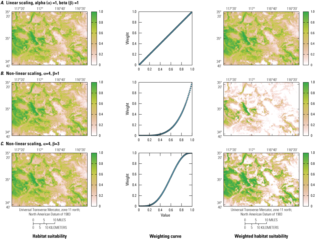
Demonstration of how varying the function, raster weight, and scaling parameters can change the weighting curve of the probabilistic change of the criterion in the model and habitat suitability from the original non-weighted and non-scaled criteria. A, Linear 1:1 weighting function of the criteria and habitat suitability where weight and scaling are set to 1; B, Non-linear scaling of habitat suitability where scaling parameters α and β are set to 4 and 1, respectively; and C, Non-linear scaling of habitat suitability where scaling parameters α and β are set to 4 and 3, respectively.
Decision Scenarios
Five variations of the raster scaling were combined to create modeling scenarios thought to be important for desert tortoise translocation success (app. 2). For each scenario, the set weight and bounds of each criterion were developed using information based on expert knowledge of the authors. These scenarios were discussed with personnel from agencies with administrative responsibilities for the study area (BLM—Chris Otahal, Jeffrey Childers, Amy Fesnock, Mark Massar; NTC—David Houseman, Craig Penn, and David Davis; USFWS—Brian Croft and Kristina Drake), and feedback on guidelines for appropriate areas in relation to agency policies were shared. We attempted to contact staff from CDFW but received no response. Lands owned by the State of California will not have tortoises released on them.
Our base scenario included all input rasters, which were represented by their baseline values of “1” after being standardized (table 2; app. 2). The second scenario was focused on urban and disturbed areas in the study site (table 2; app. 2). The urban areas included cities such as Barstow and Hinkley, which are all close to major roads and in the southern region of the study area. The roads layer also included a large network of paved and dirt roads (including BLM designated trails and unmaintained dirt roads). The third scenario focused on raven nest density (table 2; app. 2), given ravens are well-known predators of the desert tortoise (Boarman and others, 2006; McIntyre and others, 2010; Xiong, 2020; Holcomb and others, 2021), and the eastern part of the study area contains a large network of transmission lines that are used by ravens for nesting (Xiong, 2020). Recent raven monitoring and management efforts have focused on reducing raven populations throughout the desert tortoise critical habitat units (Shields and others, 2019; Dettenmaier and others, 2021; Currylow and others, 2021; Holcomb and others, 2021; Sanchez and others, 2021). Although the results of those efforts have been positive across the desert in every Critical Habitat Unit besides Superior-Cronese (K. Holcomb, U.S. Fish and Wildlife Service, oral commun., 2022), this scenario provides an optimistic consideration of the future effects of these management actions by including a decreased probability of raven predation pressure on desert tortoises. Increased management activities through adaptive management may be necessary if predation pressure increases before or after translocation (via communication or review of publications; see the “Adaptive Management” section). The fourth scenario focused on the probability of suitable tortoise habitat (table 2; app. 2). One important aspect of improving habitat suitability includes restoration efforts that have been done in the area to reclaim road incursions. The BLM has committed to continue restoration and maintenance of these sites with the goal of increasing habitat quality, and this raster was designed to test the effect of this on-site selection. Additionally, the fourth scenario prioritizes areas with a higher probability of precipitation during drought years. The fifth scenario was a synthesis of scenarios 2–4 (tables 2, 3; app. 2).
Table 2.
Initial scenarios included for prioritizing areas for Mojave Desert tortoise translocation sites.[Each scenario builds upon previous scenarios, resulting in the final selected model. Weights (w) were determined by expert knowledge and remained consistent throughout each scenario. The lower (α) and upper (β) bounds for each criterion were manipulated for each scenario (app. 2)]
Table 3.
Set weights and bounds used for scenario 5, which was selected as the chosen possible outcome that was believed to be the most biologically important and most likely outcome for tortoises in the study area.[The site selection model was used to develop different scenarios that built upon each other to create the final model used to select suitable sites for translocated tortoises in the Western Training Area Translocation Site (WTATS). Expert knowledge on desert tortoise ecology and habitat, as well as on-the-ground knowledge of the WTATS determined the set weights (w) and manipulated lower (α) and upper (β) bounds for each criterion. Areas with suitable habitat for tortoises with low raven nest densities (potential predators) were highly considered for recipient sites. Distance to urban areas had a lower weight because NTC-owned mitigation parcels were located in areas with low urban development]
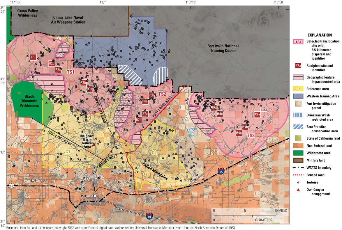
To identify the sites that met selection criteria in the most robust way, the results from scenario 5 were analyzed to identify which areas in the WTATS received higher ratings as suitable translocation sites. From the combined analyses, we selected eight potential recipient sites and two potential reference areas that contained large contiguous parcels and that were ranked as highest suitable habitat for tortoises by the model (figs. 6, 7). Most of the selected parcels from scenario 5 also were repeatedly selected from other scenarios, except for parcels R3b, 5b, and R8a. Selected recipient sites are owned by the NTC (Fort Irwin mitigation parcels) and in areas outside of the excluded habitat (see the “Site Selection Guidance from the Bureau of Land Management” section). The recipient sites were ranked in order from highest priority (R1) through lowest priority (R8b, where “a” is higher than ‘”b”). A 6.5-km movement buffer was created from the centroid of each selected Fort Irwin mitigation parcel (recipient sites), resulting in three potential translocation sites for translocated tortoises (TS1, TS2, TS3; may vary depending on exact release site of translocated tortoises). The geographic features in the study area demonstrate where tortoise movements may be limited by geography, such as mountain ranges and fenced roads, if released at recipient sites. For example, tortoises released at R5a and R5b may have limited movement to areas within the 6.5 km to the west due to Coyote Lake.
The habitat suitability model translocations in the WTATs included six criteria: (1) Desert tortoise habitat potential (Nussear and others, 2009); (2) desert tortoise movement potential (Gray and others, 2019); (3) average winter precipitation; (4) raven nest density (considering anthropogenic and natural nest densities; Xiong, 2020); (5) distance to roads (including highway, public, and field roads); and (6) Terrestrial Development Index (TDI, a measure of the cumulative anthropogenic effects within a 1-km window; Carter and others, 2020). Parcels, owned by the NTC, with a suitability value greater than or equal to the mean model value (for example, greater than or equal to 0.39) were considered as potential recipient sites for translocated tortoises from the WTA (fig. 7).
The model output and selected sites were interpolated to color maps for discussion with the BLM, NTC, and USFWS. Selected recipient sites (R1–R8b) were grouped together to form three translocation sites (TS1–TS3) based on intersecting 6.5-km movement buffers. Recipient sites and translocation sites are numbered and alphabetized (“a” is chosen before “b”) based on model value (1=higher value and 8=lower value). In this system the highest priority for translocation is the lowest number and alphabet combination. For example, the NTC can release tortoises in TS1 first and in the following order for recipient site: R1, R2a, R2b, R3a, and lastly R3b. Furthermore, chosen reference areas (C1, C2) highlight the general tortoise population that can be used as reference populations and are dependent on where translocation is done.
Reference sites should be a minimum distance of 10 km away from an unfenced recipient site that has no substantial barriers to tortoise movement (U.S. Fish and Wildlife Service, 2020). For example, if tortoises are released in TS1, then the reference population should be either in the southern region of C1 or anywhere in C2 so that the sample number of required tortoises (n=75–100) is met. However, if only TS1 and TS2 are chosen as the designated translocation sites for all tortoises in the WTA, then TS3 can be chosen as the reference site. If only TS3 is chosen, then TS1 or TS2 can be used as reference sites. Reference populations are valid when home ranges of tortoises do not overlap with other study groups (translocated and resident populations). Therefore, tortoise home ranges can be analyzed every 3 months during the first 3 years of translocation and annually after the fourth year to ensure that the study group to which an animal is assigned is still valid. If home ranges do overlap, then any reference tortoise whose home range overlaps with a resident tortoise is then considered a resident tortoise. The study group designation of translocated tortoises does not change by contact with tortoises of other groups.
Site Visitation
Potential recipient and reference sites were visited by authors of this report and USGS staff members extensively from spring 2020 to fall 2022. Representative digital photographs were recorded at the center of each proposed recipient and reference site or grouped sites in fall 2022 (app. 3). Field crew members visited each site on BLM designated open routes. By visiting the sites, we concluded that some were unsuitable for tortoise translocation because of excessive OHV use or other anthropogenic effects (for example, private property, radio tower access, and utility corridors). Those sites were disqualified as potential translocation sites. Selected recipient and reference areas are described later in the text and were characterized by typical desert tortoise habitat in mixed shrub communities mostly dominated by Larrea tridentata and Ambrosia dumosa (Nussear and Tuberville, 2014). The BLM, NTC, and non-government organizations have cooperated to make substantial investments in habitat restoration throughout large parts of the general site and in reducing road incursions, leaving access on a network of designated roads.
Translocation Site 1
-
Recipient site R1—Easily accessible from a designated two-track dirt road (fig. 6; app. 3—site photographs). There was no evidence of recent (since 2020) unauthorized OHV use at the site center; however, several designated BLM roads and established campsites are in the general area closer to the dry lake and east of the recipient site. The center of this recipient site is on a gentle hill that slopes into a wide, flat, and open expanse to the northeast. Medium-sized rolling hills of moderate slope are to the southwest. The soil is soft, sandy loam topped with gravel composite and suitable for tortoise burrows. Small mammal burrows were present in high density throughout the site. Vegetation consisted primarily of Larrea tridentata, Ambrosia dumosa, and Ephedra californica (and Ephedra nevadensis (California and Nevada jointfir; respectively) as well as several other less dominant species, such as Acamptopappus sphaerocephalus (rayless goldenhead) and Thamnosma montana (turpentine broom).
-
Recipient sites R2a and R2b—Accessible from designated two-track dirt roads and are 1.5–3 km south of a dry lake (fig. 6; app. 3—site photographs). Like R1, designated BLM roads and established campsites are concentrated further north from R2a and R2b, toward the dry lake. Both sites are generally in flat areas that gently slope down in their northern sections toward the dry lake. At these sites, sandy soil is interspersed by rocks. The dominant vegetation is comprised of Larrea tridentata, Ephedra californica, Ephedra nevadensis, and multiple Atriplex species (saltbushes).
-
Recipient sites R3a and R3b—Are from 3 to 6 km south of the southern fenced WTA border and off two-track dirt roads just west of the graded Copper City Road (fig. 6; app. 3—site photographs). There are more trafficked designated two-track dirt roads that skirt the boundaries of R3a and R3b. These sites are comprised of low hills with sandy soil containing some gravel. Vegetation is dominated by Larrea tridentata and Ambrosia dumosa. Yucca brevifolia (Western Joshua trees) are present but more numerous in the southern region of R3a at higher elevation.
Translocation Site 2
-
Recipient sites R7a and R7b—Easily accessible from a dirt BLM road from the north and west with only moderate OHV use noted (fig. 6; app. 3—site photographs). The sites were approximately 3 km from a major paved tortoise-fenced road (Fort Irwin Road). Private properties with trailers are east of the recipient sites, but within the translocation site on the northeast boundary, just off Fort Irwin Road. A private property with dozens of trailers in the recipient site area is closer to Fort Irwin Road. The site is surrounded by mountains with moderate eastward facing slopes. Soil is characterized as sandy, gravelly loam. The shrub community is dominated by small Larrea tridentata (most less than or equal to 1 m tall) and Ambrosia dumosa. Annual vegetation from the previous year was present on the landscape.
-
Recipient sites R8a and R8b—Are within 1.5–4 km of the WTA to the north (fig. 6; app. 3—site photographs). Between these sites is two-track Paradise Valley Road, which connects Fort Irwin Road to the gated southern edge entrance to the WTA. The sites are moderately sloped from mountains to the west and east, consisting of semi-rocky and sandy soil with outcrops of fine-grained consolidated sediments in the north. R8a and R8b contain the densest and tallest vegetation (Larrea tridentata and Ambrosia dumosa) of all the recipient sites.
Translocation Site 3
-
Recipient sites R4a and R4b—Accessible via an unmarked two-track road, approximately 3 km from a primary transmission utility corridor to the south and approximately 300 m up a gentle slope (fig. 6; app. 3—site photographs). Although there are marked BLM roads south of these sites, minimal to no OHV disturbance was observed in these recipient areas. These sites are east of the Alvord Mountain Range and west of a plateau with a radio tower, which is approximately 60 m from the site center. The sites are typified by low gravelly and sandy hills with outcrops of fine-grained consolidated sediments and several moderately deep (2–5 m) washes. R4a and R4b are dominated by mixed Larrea tridentata and Lycium cooperi (peach thorn) as well as Ambrosia dumosa and Senna armata (desert senna). Vegetation at this site was sparser than most other recipient sites.
-
Recipient sites R5a and R5b—Accessible from a two-track road off graded Manix Trail Road, which is used by the NTC to transport military equipment to and from the southern NTC border and the I–15 (fig. 6; app. 3—site photographs). There was only one OHV trail running through R5a, with other trails ending just to the southwest of these sites. R5a and R5b are west of the Alvord Mountain Range and northeast of Coyote Lake (approximately 4 km) and are characterized by low hills. Soil is mostly sandy, littered with surface rocks near the bajada to the south and east, and dense volcanic gravel covers the hillsides. Vegetation primarily is Larrea tridentata, Ambrosia dumosa, and Senna armata.
-
Recipient sites R6a and R6b—Are just south of the Alvord Mountain Range and north of a primary utility transmission corridor (fig. 6; app. 3). Additionally, the Old Spanish National Historic Trail is marked on the west side of the sites. The sites are on low hills and generally slope down to the south. The soil is very sandy with relatively sparse vegetation on the southern end of the site. Dominant vegetation included Larrea tridentata, Ambrosia dumosa, and Senna armata, but vegetation is the sparsest of all the recipient sites.
Reference Sites C1 and C2
The potential reference sites (C1 and C2) are north of the Interstate Highway 15 corridor. Reference site C1 is north of Barstow, Reference site C2 is east of Barstow, and they are separated by Fort Irwin Road and south of all the Recipient Sites (fig. 6; app. 3—site photographs). However, the reference sites also stretch northwest, north, and northeast from Barstow and areas within them are as far or farther (approximately 26 km at furthest point) from the cities than the release sites (fig. 6; app. 3—site photographs). C1 contains the more private land holdings to the south, but also Black Mountain Wilderness (BLM), BLM recreation areas (Rainbow Basin natural area, Owl Canyon campground) to the southeast, and two graded dirt roads (Fossil Bed Road and Copper City Road). C1 has variable terrain, soil, and vegetation, areas with larger hills and canyons, and rockier soils and denser Larrea tridentata, Ambrosia dumosa, and Yucca brevifolia in the north. The southern part of C1 has smaller rolling hills, sandier soil, and sparser vegetation. C2 is bordered by the tortoise-fenced I–15 highway to the south and has more private properties and motorized recreation areas in the south and west. C2 also encompasses the Calico Mountains and is southwest of Coyote Lake (unsuitable for tortoises; fig. 7). In C2, soil is coarse, sandy loam with a mixed shrub Larrea tridentata and Ambrosia dumosa community among large hills and canyons, turning to medium grade slopes to the north and south.
The 15 Fort Irwin mitigation parcels selected for potential recipient sites (R1 through R8b) and two larger reference areas (C1 and C2) within the Western Training Area Translocation Site (WTATS).
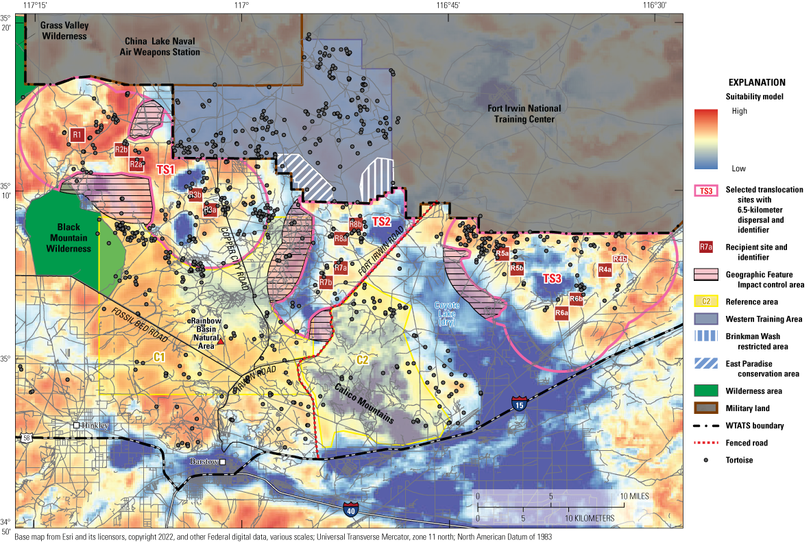
The site suitability model (low suitability=0 to high suitability=1) for the Western Training Area Translocation Site (WTATS) including six habitat criteria.
Tortoise Density Estimates
Populations of reptiles, such as desert tortoises, are most efficiently surveyed with spatially structured transects or spatially unstructured area searches (Allison and McLuckie, 2018; Mitchell and others, 2021b; Royle and Turner, 2022; Zylstra and others, 2023). To produce reptile population density and abundance estimates, detection data from transect surveys are typically analyzed with distance sampling models, whereas detection data from area/plot searches are typically analyzed with nonspatial capture-recapture models. However, many reptiles have characteristics that present challenges when attempting to use those models to estimate density and abundance. For example, conventional line-distance sampling models assume that detection of individuals of the focal species that are directly on the transect line (that is, distance equals 0 from the line) are all found (that is, perfect detection). However, some species, such as desert tortoises, violate these assumptions because a portion of individuals likely are in burrows and not visible to observers (detectors) when a given transect is surveyed (Allison and McLuckie, 2018). In contrast, spatial capture-recapture (SCR) models overcome many of those issues by incorporating the spatiotemporal information about survey effort and the locations where individual animals were detected in estimations. These data are accommodated in SCR models with a spatially explicit observation submodel and an ecological submodel that describe animal distribution (density) as a realized Poisson point process (Efford, 2004; Borchers and Efford, 2008; Royle and others, 2014). All spatial information collected on Global Positioning Systems and used in mapping and analyses use the North American Datum of 1983 (NAD 83).
Technological Framework
We estimated seasonal tortoise densities and abundances from spatially structured plot surveys and spatially unstructured area searches using SCR models in a spatially explicit search area-encounter approach (Efford, 2011; Royle and others, 2011; Russell and others, 2012; Thompson and others, 2012; Royle and Turner, 2022). We converted the tortoise detection data from the search area-encounter approach to three-dimensional spatially explicit detection histories comprised of individual by location by survey occasion detections (Royle and Turner, 2022).
To facilitate estimation of season by year-specific tortoise densities and abundances, we subset the tortoise detections by year and season (spring 2020, fall 2020, spring 2021, fall 2021, spring 2022). We also subset the surveyors’ GPS search tracks by year and season to allow us to account for the spatially and temporally varying survey effort within each season by year combination. We then plotted season by year detections and surveyor search tracks in ArcMap 10.4 (ESRI, Redlands, California) and used the Create Fishnet tool to discretize ad hoc survey grids that encompassed the detections and search tracks for a given season by year combination. Each grid cell represented an “effective detector” to which tortoise detections and occasion-specific surveyor effort (meters searched) that happened within that cell were assigned (Russell and others, 2012; Thompson and others, 2012; Royle and Turner, 2022).
Desert tortoise home range sizes and mean daily movements often differ considerably between spring and fall seasons (Harless and others, 2010; Franks and others, 2011; Averill-Murray and others, 2020). Therefore, to prevent discretization bias in density and abundance estimates (Russell and others, 2012; Thompson and others, 2012), we specified season-specific grid cell spacings based on mean seasonal range size estimates that we generated from very high frequency (VHF) and GPS telemetry monitoring of tortoises in the study area via 95-percent autocorrelated kernel density estimation (AKDE), which we produced using continuous-time movement models (Fleming and others, 2014, 2015; Calabrese and others, 2016; Averill-Murray and others, 2020). From those mean seasonal 95-percent AKDEs, we derived approximate SCR model spatial scale of detection parameter (σ) values for each season, assuming a bivariate normal distribution (Efford and others, 2013; Royle and others, 2014; Sun and others, 2015). We used those derived season-specific σ values to discretize the grids of “effective detectors” with a cell spacing of 1.5–3×σSeason, which is the range of detector spacings within which SCR models have been shown to produce unbiased parameter estimates (Sun and others, 2015; Milleret and others, 2018; Clark, 2019).
-
Observation model—We used a Poisson observation model for the detection process for two primary reasons: (1) the close 10-m spacing between transects relative to the coarser discretized grid cell spacings resulted in the potential for multiple tortoises to have been detected within a given grid cell during a given survey occasion (Royle and others, 2014) and (2) in contrast to the oft-employed Bernoulli observation model, the Poisson observation model retains all detections and produces SCR model parameter estimates that are nominally biased when detections are spatially aggregated within discretized grid cells (Milleret and others, 2018). Detection probability in the Poisson observation model is often best parameterized as exposure, or cumulative hazard, for which we specified a hazard half-normal detection function. This detection function described the rate of decay in baseline detection rate at an individual’s activity center (λ0) as a function of distance between the activity center and grid cell in which the individual was detected, represented by the σ parameter (Royle and others, 2011). The baseline detection rate ( λ0 in eq. 4) is easily converted to the binomial detection probability (g0 in eq. 4) that is used in conventional line-distance sampling models via equation 4 (Royle and others, 2014; Crum and others, 2021; Efford, 2022a):
We accounted for spatially and temporally varying survey effort by first summing the occasion-specific total track lengths (m) that surveyors walked within each grid cell and then calculating the track length quartiles and classifying effort into five classes to improve model fitting. We specified hazard-based survey effort effects in all models to denote during which occasions each grid cell was surveyed or not (Russell and others, 2012; Thompson and others, 2012; Efford and others, 2013; Royle and Turner, 2022). Considering the well-documented sex discrepancy in home range sizes and movements of desert tortoises (Averill-Murray and others, 2020), we expected that detection rates and movements would differ between sexes, so we modeled a two-class sex effect on both the λ0 and σ parameters (Gardner and others, 2010; Mitchell and others, 2021b).
-
Ecological process model—A primary assumption of SCR models is that individual animals in a population have activity centers, or home range centers, around which their activities are primarily concentrated. The collection of those activity centers is a realization of a statistical point process probability model that characterizes the number and spatial distribution of activity centers within an explicit spatial region, termed the state space or area of integration (S; Efford, 2004; Borchers and Efford, 2008; Royle and others, 2014). S is analogous to the ad hoc “effective sampling area” that is used to derive density from abundance that is estimated by nonspatial models, except that S is explicitly defined in SCR, based largely on the movement distances of individual animals among the locations at which they were detected (for example, spatial recaptures; Borchers and Efford, 2008; Royle and others, 2014).
To ensure that S was large enough to contain all individuals that had a non-negligible probability of detection while also preventing truncation bias in density and abundance estimates, the discretized grid cells were buffered by 3–5×σSeason to define the spatial extent of S (Royle and others, 2014; Efford, 2022b). However, multiple anthropogenic and natural landscape barriers existed in the study area that impeded tortoise movements, such as tortoise exclusionary fencing along major roads and unvegetated dry lake beds and playas. If such movement barriers were not accounted for, density and abundance estimates would be negatively biased (Royle and others, 2014; Efford, 2022b). Those barriers effectively divided the larger NTC into three smaller study areas (WTA, WTATS-West, and WTATS-East), and tortoise movement among those three areas was not possible because of the barriers. Therefore, we manually adjusted the spatial extent of each S to reflect those barriers and improve accuracy of SCR model parameter estimates. Additionally, for likelihood evaluation, S must be comprised of a discrete mesh of latent points that constitute potential animal activity center locations; therefore, we specified mesh point spacings of 0.6–0.9×σ for each S, per the recommendations from prior SCR model development and validations (Royle and others, 2014; Sutherland and others, 2019; Efford, 2022b).
Home range centers (number and distribution of tortoise activity centers) were described using two separate ecological point process models in each parameter estimation area, or S (Borchers and Efford, 2008; Royle and others, 2014). We first fit all SCR models that included the aforementioned observation model effects with a homogeneous Poisson point process ecological model, which assumed that individual tortoise activity centers were randomly distributed throughout each S (Borchers and Efford, 2008; Royle and others, 2014). This process allowed us to efficiently identify the most supported sources of variation in the observation model’s detection function parameters. We then fit SCR models that included those supported observation model effects but used an inhomogeneous Poisson point process ecological model that allowed the number and spatial distribution of tortoise activity centers to spatially vary as a function of an ecological covariate (Murphy and others, 2016, 2017; Laufenberg and others, 2018; Stetz and others, 2019). We used the predicted raster from the existing desert tortoise habitat suitability model (Nussear and others, 2009) as a covariate for describing spatial variation in tortoise density, and we modeled tortoise density as a log-linear function of the Habitat Suitability Index (Murphy and others, 2016, 2017, 2023; Laufenberg and others, 2018; Stetz and others, 2019).
Model Fitting and Model Selection
We fit SCR models via maximum likelihood using the package secr in the R statistical computing environment (Borchers and Efford, 2008; Efford, 2022a; R Core Team, 2022). We analyzed each study area by-season by-year dataset separately, fitting the same suite of a priori SCR models to each of the 10 datasets (in other words, we did 10 separate SCR analyses). For each analysis, we did information-theoretic model selection using Akaike’s information criterion corrected for small sample size (AICc; Burnham and Anderson, 1998), producing parameter estimates from the top-ranked, most parsimonious SCR model for each area by-season by-year analysis. The base SCR model parameters that we estimated were tortoise density (D), λ0, and σ; whereas tortoise abundance (N) was derived from estimated D as the expected number of individuals in each S (for example, E[N]=D×S; Borchers and Efford, 2008). We used the R package raster (Hijmans and van Etten, 2012) to produce predicted density surfaces of supported area by-season by-year spatial relationships between tortoise density and habitat suitability that were estimated by the inhomogeneous Poisson point process SCR models (Murphy and others, 2016, 2017, 2023; Laufenberg and others, 2018; Stetz and others, 2019).
-
Post-hoc analyses—The temporal span and spatial extent of our surveys allowed us to produce 10 separate density estimates that represented three distinct study areas. Therefore, we derived estimates of average seasonal study-area specific population growth rates using the exponential growth equation described by Gotelli (2008). Additionally, to investigate potential trends or sources of bias in density estimates relative to the characteristics of survey results, we did post-hoc analyses using generalized linear models (GLMs; Tobler and Powell, 2013; Jędrzejewski and others, 2018; Murphy and others, 2022; Schmidt and others, 2022). We fit four separate GLMs with the SCR estimated densities as the response variable and the total numbers of tortoises detected, recaptures, spatial recaptures, survey occasions, and S sizes as the predictor variables. We were forced to fit four models because of moderate to high correlation between the number of tortoises detected and S extents (r=0.58) and between the numbers of recaptures and spatial recaptures (r=0.95), which prevented inclusion of those pairs of predictors in the same GLMs (Zuur and others, 2010). For all four models, we centered and scaled all predictor variables before model fitting, specified a Gamma error distribution with a log link function (Schmidt and others, 2022), and fit models using the glmmTMB package in R (Brooks and others, 2017). From the resulting coefficient estimates, we produced predicted marginal effects using the package ggeffects (Lüdecke, 2018).
Spatial Capture-Recapture and Survey Results
Movements and Detection Rates
The number of survey occasions ranged from 28 to 55 days, depending on season, year, and study area (table 4). Mean search effort per grid cell ranged from 247 meters per cell (m/cell) during spring 2022 at WTA to 1,625 m/cell during spring 2020 at the WTATS-West. The average number of tortoises detected during a given survey in a certain study area was 117 individuals (range: 52–180), and an average of 6 individual tortoises were detected per day. The average number of recaptures obtained during a given survey in a certain study area was 108 (range: 6–266), whereas the average number of spatial recaptures (in other words, tortoise detected in greater than 1 grid cell) obtained during a given survey in a certain study area was 43 (range: 2–143).
Table 4.
Study area specific detection results and survey design metrics for ground-based surveys of adult Mojave Desert tortoises at Fort Irwin, California.[m, meter; WTATS, Western Training Area Translocation Site]
Male tortoises tended to have substantially larger σ estimates and, therefore, larger range sizes than females, whereas females tended to have higher λ0 estimates and, therefore, higher detection probabilities than males. Mean σ across all 7 of the analyses in which sex-varying σ was present in the top-ranked model were 211.14 m and 149.74 m for males and females, respectively. Assuming home ranges were bivariate normally distributed (in other words, approximately circular; Royle and others, 2014; Sun and others, 2015), those σ values corresponded to average seasonal range sizes of 0.84 km2 and 0.42 km2 for males and females, respectively. Among the four analyses in which sex-varying λ0 was present in the top-ranked model, mean λ0 was 0.09 and 0.16 for males and females, respectively. In contrast, among the six analyses in which the top-ranked model indicated that λ0 did not differ between sexes, the mean λ0 was 0.15. Across all 10 analyses, each area was estimated to have a male-biased sex ratio within each season by year, ranging from 53 percent to 71 percent males versus from 29 percent to 47 percent females. For the NTC across all areas, seasons, and years, the mean sex ratio was 64 percent males versus 36 percent females.
Tortoise density spatially varying as a function of habitat suitability was included in the top-ranked model for three of the analyses, and all three of those estimated relations were positive (tables 5–7; fig. 8). Among the seven analyses in which a density-habitat relationship was not present in the top-ranked model, a competing model (∆AICc less than 2) contained that relationship in six of those analyses, indicating that was supported for nearly all areas within each season across years. However, in one case (WTA during spring 2021), the competing model with the density-habitat suitability relationship had a coefficient estimate with 95-percent confidence interval (CI) that overlapped zero, a nominal change in model log-likelihood relative to the top-ranked model, and the same model weight as the top-ranked model, all of which indicated that the habitat suitability covariate was uninformative for that particular dataset (Arnold, 2010). The completely null model (in other words, spatially random density, λ0 and σ shared between sexes) was the top-ranked model for three of the analyses, which were also the three datasets with the fewest total number of recaptures (WTA spring 2021, WTA spring 2022, and WTATS-West spring 2021).
Table 5.
Spatial capture-recapture model selection results for the Western Training Area (WTA) study area in each season by year combination from surveys of Mojave Desert tortoises at Fort Irwin, California (2020–22).[Estimated model parameters were density (D), baseline detection rate (λ0), and spatial scale of detection (σ). We considered models in which tortoise density was spatially random (approximately [~] 1) or density varied spatially as a log-linear function of habitat suitability that estimated from a previous analysis (habitat; Nussear and others, 2009), and we allowed λ0 and σ to differ between sexes (Sex) or be shared between sexes (about 1). Abbreviations: AICc Akaike's Information Criterion corrected for small sample size; ∆AICc, difference between AICc value of the model and AICc value of the top-ranked model]
Table 6.
Spatial capture-recapture model selection results for the Western Training Area Translocation Site (WTATS)-East study area in each season by year combination from surveys of Mojave Desert tortoises at Fort Irwin, California (2021–22).[Estimated model parameters were density (D), baseline detection rate (λ0), and spatial scale of detection (σ). We considered models in which tortoise density was spatially random (approximately [~] 1) or density varied spatially as a log-linear function of habitat suitability estimated from a previous analysis (habitat; Nussear and others, 2009), and we allowed λ0 and σ to differ between sexes (Sex) or be shared between sexes (~1). Abbreviations: AICc Akaike's Information Criterion corrected for small sample size; ∆AICc, difference between AICc value of the model and AICc value of the top-ranked model]
Table 7.
Spatial capture-recapture model selection results for the Western Training Area Translocation Site (WTATS)-West study area in each season by year combination from surveys of Mojave Desert tortoises at Fort Irwin, California (2020–22).[Estimated model parameters were density (D), baseline detection rate (λ0), and spatial scale of detection (σ). We considered models in which tortoise density was spatially random (approximately [~] 1) or density varied spatially as a log-linear function of habitat suitability that was estimated from a previous habitat suitability analysis (habitat; Nussear and others, 2009), and we allowed λ0 and σ to differ between sexes (Sex) or be shared between sexes (~1). Abbreviations: AICc Akaike's Information Criterion corrected for small sample size; ∆AICc, difference between AICc value of the model and AICc value of the top-ranked model]
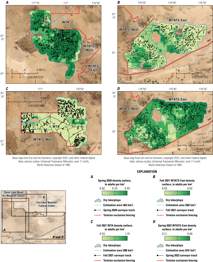
Estimated tortoise density surfaces for survey areas (Western Training Area [WTA], Western Training Area Translocation Site [WTATS], split into WTATS-West and WTATS-East) within the years (2020–22) and season (spring or fall) combinations for which spatial variation in density (adults per square kilometer [adults/km2]) as a function of Habitat Suitability Index was supported. A, Spring 2020 density surface, in adults/km2; B, Fall 2021 WTATS-East density surface, in adults/km2; C, Fall 2021 WTA density surface, in adults/km2; and D, Spring 2022 WTATS-East density surface, in adults/km2.
Density Estimates for the Western Training Area Translocation Site and Western Training Area
Accounting for the spatiotemporally varying survey effort (meters searched/grid cell/occasion) resulted in, on average, 16-percent increases in mean density estimates. Point estimates of mean density ranged from 0.27 to 1.85 adult tortoises per square kilometer (tortoises/km2), with an average for NTC across all 10 area-by-season-by-year estimates of 0.95 adult tortoises/km2 (fig. 9). All the SCR density estimates are within the range of densities predicted for the Superior-Cronese Tortoise Conservation Area (range: 0.24–3.99) for a similar timeframe (2020; Zylstra and others, 2023). Study area-specific mean densities, averaged across seasons and years, were 1.08, 0.51, and 0.95 adult tortoises/km2 at WTA, WTATS-East, and WTATS-West, respectively. Density estimates were generally lower during the fall season than the spring season, differing by as much as 105 percent between seasons within a study area, and density estimate precision (coefficient of variation; CV) ranged from 0.10 to 0.19, with a mean of 0.14 across all 10 area-by-season-by-year estimates.

Point estimates, with 95-percent confidence interval, of spatially explicit mean density (adult tortoises per square kilometer) of Mojave Desert tortoises in the A, Western Training Area National Training Center Fort Irwin, California; B, Western Training Area Translocation Site East (WTATS-East); and C, Western Training Area Translocation Site West (WTATS-West) from the top-ranked spatial capture-recapture models during 2020–22.
-
Post-hoc analyses—Estimated density increased over time in all three study areas such that the derived average seasonal population growth rates across the duration of sampling were 1.52 (95-percent CI: 1.19, 1.77), 1.32 (95-percent CI: 1.07, 1.64), and 1.55 (95-percent CI: 1.48, 1.63) at WTA, WTATS-East, and WTATS-West, respectively. Results from our Gamma GLMs indicated a strong positive relationship between tortoise density and number of tortoises detected (β=0.29; 95-percent CI: 0.1, 0.48; p=0.003), whereas strong negative relationships existed between tortoise density and numbers of recaptures and spatial recaptures (βRecaps=−0.47; 95-percent CI: −0.65, −0.29; p<0.0001; βSpatRecaps=−0.42; 95-percent CI: −0.64, −0.20; p=0.0002). Density estimates were invariant to the number of survey occasions and the study area (state space) sizes (βOccasion=−0.06; 95-percent CI: −0.29, 0.16; p=0.57; βArea=−0.002; 95-percent CI: −0.26, 0.25; p=0.99).
Predicted Densities for Western Training Area Translocation Sites
We predicted mean spatial tortoise densities for each translocation site by converting the Habitat Suitability Index raster (Nussear and others, 2009) into spatially explicit densities using coefficient estimates from the top-ranked SCR-Habitat Suitability Index models for season by year combinations. The SCR model-predicted density surfaces were created by using the ArcMap Raster Calculator function and using the following conversion equation for log-linear relations:
whereβDensity
is the coefficient estimate for the density parameter, and
βCovariate
is the coefficient estimate for the covariate parameter.
New rasters of the mean cell values (densities) among the above three predicted density surfaces were produced for each Translocation Site (TS1, TS2, and TS3) using ArcMap’s Cell Statistics function (fig. 10). We clipped the resulting mean values raster to each translocation site to obtain site-specific means, SEs, and 95-percent CIs.
-
• TS1 (355 cells): Mean=0.47 adults/km2; SE=0.0114; 95-percent CI=0.46–0.48
-
• TS2 (350 cells): Mean=0.43 adults/km2; SE=0.0126; 95-percent CI=0.42–0.44
-
• TS3 (178 cells): Mean=0.41 adults/km2; SE=0.0220; 95-percent CI=0.39–0.43
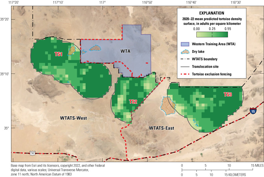
Predicted mean density surfaces for each Translocation Site (TS1–TS3) in the Western Training Area Translocation Site (WTATS; 2020–22).
Post-Translocation Density Estimates for Western Training Area Translocation Sites
The mean estimated adult tortoise density at WTA, averaged among estimates produced during 2021–22, was 1.08 adults/km2 (95-percent CI: 0.44–1.73), which corresponds to 273 live adult tortoises (greater than 180 midline carapace length [MCL]) in the WTA (95-percent CI: 111–438 adults) to be translocated to the WTATS. The density of tortoises in the translocation sites will not exceed 1 standard deviation above the mean density for that area (U.S. Fish and Wildlife Service, 2020). The estimated threshold for the Superior-Cronese is a density of 3.9 adult tortoises/km2 and was calculated from the USFWS range wide monitoring program (Allison and McLuckie, 2018; U.S. Fish and Wildlife Service, 2020). Based on field data from 2020 to 2022, the estimated densities for WTATS-East, WTATS-West, combined, and within each translocation site are below the tortoise density threshold. Translocation into each site is estimated to increase local densities while not exceeding the threshold (table 8).
Table 8.
Adult tortoise density estimates before and after translocation (includes release and surrounding areas to which tortoises are expected to disperse).[Post-translocation density and abundance are estimated based on a range of potential translocated animals to each site (from 0 to 438 animals; the upper confidence interval of estimated number of adult tortoises). Estimated density and number of adult tortoises are based on data collected from April 11, 2020, to September 12, 2022. Abbreviations: km2, square kilometer; #, number; WTA, Western Training Area; WTATS, Western Training Area Translocation Site; —, not applicable]
Tortoise Clearance Protocols for the Western Training Area
The procedures in this section and the three major sections “Tortoise Disposition Plan and Translocation Package,” “Translocation of Tortoises from the Western Training Area,” and “Post-Translocation Monitoring: Short and Long-Term Success Criteria” describe recommendations from the USFWS translocation guidance (U.S. Fish and Wildlife Service, 2020). The procedures are meant to inform the implementation of the U.S. Fish and Wildlife Service guidelines as USGS understands them, based on the scientific expertise, data, and experience of the USGS. Recommendations are not made by the USGS. Any dates are based on our understanding of the NTC’s proposed project timeline.
Tortoise clearance protocols include all activities to prepare for and implement the removal of tortoises from harm’s way as a result of a project in tortoise habitat, including (1) although not holding tortoises in pens is preferred, if required due to injury, disease, or seasonal timing of discovery, outdoor predator-proof pens may be necessary as temporary housing; (2) fencing the project area boundaries to prevent tortoise movement in and out of the area; (3) doing clearance surveys to find and attach radio transmitters to all tortoises when appropriate in the project area to monitor or place in enclosures; (4) doing health assessments and analyzing samples on all tortoises to be translocated; and (5) translocation of all tortoises from the project area to designated approved release sites and burrow crushing as outlined by the U.S. Fish and Wildlife Service (2009, 2020). Further details on clearance procedures are provided in the next sections.
To comply with timelines and USFWS guidelines, by post-translocation winter year 0 (app. 1), we suggest that (1) complete records of all tortoises found within the WTA after doing clearance surveys, along with information collected upon encounters (for example, attached unique identifier, radio transmitter, location), be collated; (2) health screenings be completed for all tortoises in the WTA, as well as for select resident and reference tortoises in the WTATS; (3) translocation release plans and landscape radio frequency plans be written; and (4) all tortoise exclusionary fence work be completed, including at tortoise containment facilities (app. 1). To acquire and compile baseline data on habitats and resident tortoises before translocations, as recommended by U.S. Fish and Wildlife Service (2020), surveys of recipient sites and tortoise monitoring (for example, home range, density, health) may likely continue through post-translocation spring year 0. During this time, tortoise exclusionary fencing around the WTA can be installed, enclosures can be constructed, and tortoises housed in enclosures cared for and monitored. We suggest that an annual meeting with regional project partners and land managers be done in preparation for translocation.
Before translocation of tortoises from the WTA, USFWS, BLM, and CDFW may require the NTC to coordinate with them to finalize the selection of recipient sites within the WTATS and inter-agency agreements regarding translocation. In addition, it would be prudent if the NTC coordinated with any entities doing ongoing research in the project area in preparation for translocation. All activities related to desert tortoises (capture, handling, and translocation) during clearance surveys will be done in accordance with the USFWS 2021 Biological Opinion (U.S. Fish and Wildlife Service, 2021a). Fort Irwin’s USFWS 10(a)(1)(A) permit will address post translocation monitoring. State permits will be obtained before translocation.
Tortoise Enclosures
Per U.S. Fish and Wildlife Service (2020) guidelines or recent husbandry guidance, construction or modification of existing outdoor predator-proof tortoise enclosures away from active training to temporarily house tortoises too small for VHF radio transmitters (including hatchlings and juveniles, or tortoises less than 300 grams [g] or 150 mm; Medica and others, 1975), or individuals with conditions that warrant additional husbandry or veterinary care, or individuals deemed unsuitable for translocation found during clearance surveys, may be considered, but it is preferred not to hold tortoises in enclosures unless necessary. Containment enclosures for tortoises found to be ELISA-positive for acquired antibodies or qPCR-positive for pathogen presence of Mycoplasma and tortoises showing signs of URTD (see the “Tortoise Health Assessments, Tissue Sampling, and Laboratory Diagnostics” section) may need to be individually quarantined in pens that are double fenced to prevent penned tortoises from encountering wild tortoises outside of pens (U.S. Fish and Wildlife Service, 2020). Annual health assessments and veterinary visitations on tortoises in enclosures may be necessary. To house tortoises within enclosures, as required by USFWS, the NTC will need to prepare a tortoise husbandry plan as well—guidelines for a plan are provided in the USFWS translocation guidance (U.S. Fish and Wildlife Service, 2020). Enclosure pens meant to hold tortoises must also be constructed with tortoise exclusionary fencing (see the “Fencing and Other Considerations” section). Enclosure facilities and husbandry plans are to be approved by USFWS before clearance surveys are done (U.S. Fish and Wildlife Service, 2021a).
Habitat Clearance Surveys
Habitat clearance surveys of a proposed project area require 100-percent coverage to locate and remove tortoises above and below ground in areas where the NTC plans to do military activities (U.S. Fish and Wildlife Service, 2020). The USFWS requires that all areas of the WTA within and connected to high intensity training areas be completely searched for tortoises during tortoise clearance surveys; this is expected to start in post-translocation fall year 0 (app. 1). All clearance surveys will follow protocols outlined in the USFWS Desert Tortoise Field Manual (U.S. Fish and Wildlife Service, 2009) and the USFWS Translocation of Mojave Desert Tortoises from Project Sites: Plan Development Guidance (U.S. Fish and Wildlife Service, 2020) to effectively locate and handle tortoises appropriately in preparation for translocation. All telemetered tortoises and new tortoises (of all size classes) found during clearance surveys are to be removed from the WTA by the end of spring 2024 if military activities are to commence by year 2025 (date may vary; post-translocation year 1; app. 1).
Per USFWS guidelines (U.S. Fish and Wildlife Service, 2020), clearance survey teams will do at least two complete consecutive survey passes throughout the WTA with focused juvenile surveys done. Focused juvenile tortoise surveys will include concentric circles (25-m radius) around small tortoises during clearance surveys or around tortoise nests (Danna Hinderle, oral comm., Ironwood Environmental Consultants, 2023). If tortoises are located during the second survey pass, a third survey pass may be required by the USFWS. All clearance procedures will be done when ambient temperatures are below 95-degrees Fahrenheit (°F) and in accordance with USFWS translocation planning guidance (U.S. Fish and Wildlife Service, 2020). Our experience suggests that clearance survey teams will be most effective if they include a tortoise search team, a telemeter/data team, and a field coordination team. Search teams focus on detecting desert tortoises of all sizes and complete planned daily coverages that may vary depending on factors including weather, terrain, and tortoise densities (with maximum transect width of 5 m). There may be multiple search teams assigned to survey sections as needed. The USFWS (U.S. Fish and Wildlife Service, 2009) requires that the telemeter/data team consist of experienced desert tortoise authorized biologists (authorized by the USFWS) that can efficiently and safely handle tortoises, attach radio transmitters, and perform necessary measurements and health assessments. A telemeter team is assigned for each search team, particularly during the first pass across sections of the WTA. Following USFWS handling guidance (U.S. Fish and Wildlife Service, 2009), each telemeter team attaches a unique identifier (for example, epoxy label) and radio transmitter (if tortoise is large enough) to each encountered tortoise to monitor them at least monthly until they are translocated to a release site. The field coordination team is expected to determine the required work force, maintain communications, provide oversight for the safety of tortoises and field teams, and collect data at the end of each field day. The USFWS, CDFW, BLM and any other appropriate agencies require permits authorizing all activities related to tortoise capture and handling during clearance surveys.
Marking and Measuring Tortoises
Methods pertaining to tortoise monitoring, handling, and processing for the following sections (“Marking and Measuring Tortoises,” “Monitoring of Tortoises via Very High Frequency Telemetry or Similar Technology,” and “Tortoise Health Assessments, Tissue Sampling, and Laboratory Diagnostics”) are based on requirements from the recovery permits (number TE-63428D-0, -1) issued by the USFWS and USFWS desert tortoise handling and health assessment protocols (U.S. Fish and Wildlife Service, 2009, 2019, 2020, 2022a). All work identified in this section is subject to terms and conditions of State and Federal permits and may be altered or modified by the Federal and State wildlife agencies (USFWS and CDFW) to meet these conditions.
Every tortoise encountered during surveys is assigned a unique identifier number and radio transmitter (if large enough). The observer, date and time, tortoise number, location (UTM, acquired by a handheld GPS unit or digital application), and radio frequency tracked/attached is to be recorded (U.S. Fish and Wildlife Service, 2022a). Additional necessary information for translocation purposes such as physical measurements (mass and shell length), sex, and health assessment notes on appearance and condition can also be recorded. Microhabitat characteristics may be useful to evaluate tortoise habitat use. Characteristics such as the tortoise’s cover type (burrow, open, vegetation, rock), burrow type (soil, rock, caliche), burrow number, and vegetation information including status (alive, dead), species, and dimensions (greatest width, perpendicular axis, and height) may be recorded. Photographs of individual tortoises, as specified on the health assessment datasheet, will be taken (U.S. Fish and Wildlife Service, 2020).
Tortoise measurements will include MCL in mm measured from the center tip of the nuchal and supracaudal scutes) and plastron length (PL) in mm (measured between the notches of the gular and anal scutes) recorded in mm using metal tree calipers (tortoises greater than 180 MCL) or digital calipers (tortoises less than 180 MCL). Animal mass can be recorded using disposable flagging tape and a digital scale (for example, hanging scales or top loading balances, such as from Ohaus Scale Corporation, Parsippany, New Jersey or Escali Company, Burnsville, Minnesota) and measured to the nearest gram (U.S. Fish and Wildlife Service, 2009).
All tortoises are to be marked with a unique identifier number by gluing a paper tag to a depressed part of a vertebral or costal scute with clear epoxy (U.S. Fish and Wildlife Service, 2009, 2022a). Any numbering scheme used must be planned in coordination with the USFWS Desert Tortoise Recovery Office to avoid numbers previously assigned and distributed (U.S. Fish and Wildlife Service, 2009). Previously assigned identification numbers attached to tortoises in the WTATS and WTA include numbers in the following series: “FI” before a number in the 5000–5999 (WTA) and 7000–7999 (WTATS) range (for example, FI7229; Esque and others, 2005), or “FT” before a number in the 3000–3999 (WTATS) and 11000–11999 (WTATS and WTA) range (for example, FT11224). Tortoises found during surveys may also have their shell scutes notched using the highly modified Honegger System (Honegger, 1979; U.S. Fish and Wildlife Service, 2022a). The USFWS maintains a range-wide database of marked desert tortoises and all such activities can be coordinated through them.
Monitoring of Tortoises via Very High Frequency Telemetry or Similar Technology
Methods described in Boarman and others (1998) highlight successful attachment of VHF radio transmitters (models PD-2 [6–10-month battery [3.5 g]) or RI-2B (11-month battery [6 g]); 12 month battery (9 g); 24 month battery (14.5 g); Holohil Systems Ltd., Carp, Ontario, Canada, or similar) on tortoise carapaces using QuikSteel putty epoxy (for RI-2B models on adult tortoises) or Devcon gel epoxy (for PD-2 models on juvenile tortoises) and silicone. Tortoises found during surveys that are too small for a radio transmitter (for example, transmitter weight is less than or equal to 10 percent of the body mass of the tortoise) will be placed into individual enclosure pens so they may be released at the time of translocation (U.S. Fish and Wildlife Service, 2020). Tortoises in the WTA that are eligible for transmitter attachment are to be monitored to collect baseline data before translocation. These tortoises will later be tracked via radio telemetry and captured for translocation with a subset monitored after translocation (see the “Short-Term Metrics: Success Criteria Stages 1–3a” section).
Tortoise home range and space use can be analyzed by collecting high resolution movement data from a subset of telemetered adult tortoises (greater than 180 MCL) from each study group. GPS data-loggers (i-gotU, model GT-500, Mobile Action Technology, San Francisco, California, or similar) and associated custom-built aluminum sleds (Nevada Precision Sheet Metal, Las Vegas, Nevada, or similar) can be equipped to adult tortoises by attaching the sled to either the second or third costal scute, opposite side of the radio transmitter, and using QuikSteel putty epoxy and silicone (transmitter and GPS data-logger total weight will be less than or equal to 10 percent of the body mass of the tortoise; number TE-63428D-0, -1). Data points are best analyzed when recorded every 60 minutes and replaced each month during periods of tortoise activity before battery expiration.
While handling for equipment attachment, tortoises may void their bladder contents, which could be detrimental to their survival. If a tortoise voids during a handling encounter, rehydration via soaking, nasal-oral uptake, or epicoelomic injections may be necessary or prescribed by the USFWS (U.S. Fish and Wildlife Service, 2019; number TE-63428D-0, -1).
Any translocated tortoises will be tracked within 1–2 days of release with a complete clinical health assessment (U.S. Fish and Wildlife Service, 2020). A suggested monitoring timeline of twice weekly for the first 2 weeks after release, weekly during the first active season, and twice monthly for the duration of the first year after release may reduce the number of missing translocated tortoises. Otherwise, tortoises can be tracked at least monthly, including tortoises used as residents and references in the WTATS. Monitoring for movement patterns, habitat use, growth, survival, and other research activities throughout the year after translocation can be used to analyze short- and long- term success metrics.
Tortoise Health Assessments, Tissue Sampling, and Laboratory Diagnostics
In preparation for translocation, assessments of clinical health conditions and physiological health status in this section will follow methods detailed in a handbook titled “Health Assessment Procedures for the Desert Tortoise (Gopherus agassizii)—A Handbook Pertinent to Translocation” (U.S. Fish and Wildlife Service, 2019). Tortoises will not be eligible for translocation if health conditions show signs that may affect survival, including weakness or lethargy, moderate to severe serous or mild to severe mucoid nasal discharge, or crusts, plaques, or ulcers in the mouth (U.S. Fish and Wildlife Service, 2020). Tortoises not eligible for translocation will be held in containment enclosures and will be cared for with the protocol outlined in a tortoise husbandry plan and may be used during future or other research activities (as approved by USFWS; see the “Tortoise Enclosures” section). Tortoises with improved health may be eligible for translocation (case by case evaluation, approved by USFWS) in alternative suitable sites or in coordination with Federal and State agencies.
Before translocation, health assessments must be completed: (1) one within 1 year of translocation and (2) at least two that are 14–30 days apart, with the last assessment immediately before the translocation date (U.S. Fish and Wildlife Service, 2020). Biological tissue samples, including blood and oral epithelial cells (see next section), must be collected within 1 year of translocation (U.S. Fish and Wildlife Service, 2020). Additional health assessments will be done on a subset of animals in the resident and reference populations, with a target sample subset size estimated as those needed to detect 10-percent prevalence at the 95-percent CI and 5-percent precision (U.S. Fish and Wildlife Service, 2020).
As part of the physical health assessment, general health signs will be described, including the animal's general posture, respiration, face (with specific attention to the eyes, periocular tissue, nares, mouth, tongue, and oral mucosa), skin, and shell for any clinical signs of disease, abnormalities, damage, or discoloration (U.S. Fish and Wildlife Service, 2020). The cloaca, eyes, nares, mouth, and skin will be examined for any evidence of lesions, ulceration, erythema, swelling, or discharge and will be noted. Numerical BCS will be used to assess the overall muscle condition and fat stores with respect to skeletal features of the head and limbs. The BCS scores are first categorized as “under,” “adequate,” or “over” condition, and then numerical values are assigned to provide a precise and repeatable measurement (for example, under: 1–3, adequate: 4–6, over: 7–9; U.S. Fish and Wildlife Service, 2019). Tortoises that are eligible for translocation should have a normal attitude and respiration, have a BCS greater than 4, present no evidence of active lesions (shell and oral) or mucoid discharge (ocular and nasal), and no other health condition that may affect their survival (U.S. Fish and Wildlife Service, 2020; fig. 11).
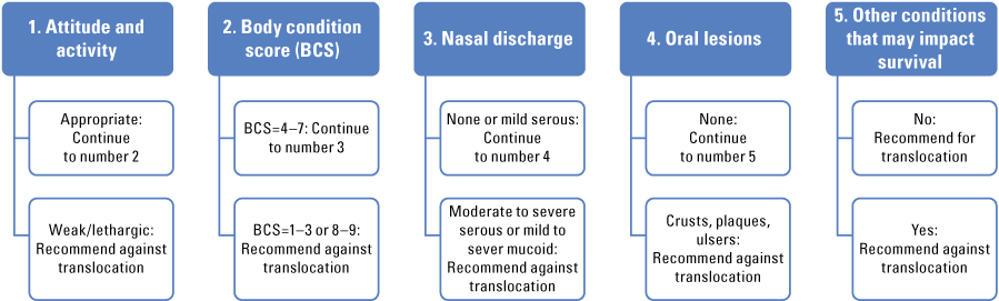
Algorithm followed during health assessments to determine suitability of translocation for individual tortoises. Body condition scores: 1–3 is under; 4–6 is adequate; 7–9 is over. (U.S. Fish and Wildlife Service, 2019).
Immediately after a physical assessment, tissues will be collected from each animal, when applicable (U.S. Fish and Wildlife Service, 2020). Other tissues may be collected, as needed, for associated research or monitoring purposes. Protocol for shipping samples will follow USFWS Health Assessment (U.S. Fish and Wildlife Service, 2019) procedures. Aliquots of plasma will be shipped on dry ice to the Mycoplasma Laboratory at the University of Florida (Gainesville, Florida) and screened for targeted immune responses (antibodies) specific to Mycoplasma agassizii (hereafter Myag) and M. testudineum (Myte), using an ELISA (measuring immunoglobulin M [IgM] and IgY light chains; Wendland and others, 2007; U.S. Fish and Wildlife Service, 2019). Results typically are reported from ELISA as negative (antibody titer less than 32), suspect (antibody titer greater than or equal to 32 and less than 64), or positive (antibody titer greater than or equal to 64). The associated absorbance (A405) values for each ELISA result may also be evaluated to better understand immune responses to Mycoplasma spp. within tortoise populations.
Sloughed epithelial cells from inside the buccal area will be collected using oral swabs (U.S. Fish and Wildlife Service, 2019). One oral swab from each sampling encounter will be shipped on dry ice to the San Diego Zoo Amphibian Disease Laboratory (Escondido, California) to detect and estimate the abundance of Myag, Myte, and TeHV2 deoxyribonucleic acid (DNA) present in the sample using qPCR (Braun and others, 2014; U.S. Fish and Wildlife Service, 2019). Results for all qPCR tests will be reported as negative, positive, or equivocal (inconclusive) based on cycle threshold (Ct) values as indicated by USFWS guidance (U.S. Fish and Wildlife Service, 2019) and experience of the USGS. The USGS suggests requesting Ct values and plasmid counts for each sample evaluated to better understand pathogen presence and pathogen load within tortoise populations. All remaining tissue samples that were collected will be stored in ultracold freezer storage (−70 °C) or other conditions as appropriate.
Priority attention will be given to assessment and sample quality, collection, processing, and care during storage, shipping, and understanding of associated results for all health-related work. All measures needed to reduce disease and pathogen transmission between tortoises and populations will be taken (U.S. Fish and Wildlife Service, 2019). All tortoises that void bladder contents will be re-hydrated using permitted methods such as soaking, nasal-oral uptake, or epicoelomic injections (U.S. Fish and Wildlife Service, 2019; see the “Monitoring of Tortoises via Very High Frequency Telemetry or Similar Technology” section).
Translocation of tortoises will focus on minimizing risk to the tortoise population, especially relative to disease transmission. Prevalence of M. agassizii can be as high as 50–90 percent in healthy populations and reveal no signs of poor body condition indices or signs of URTD that would result in an ineligible status for translocation (Sandmeier and others, 2017, 2018; Weitzman and others, 2017). Translocation of tortoises into recipient sites will maintain levels of M. agassizii and ELISA-positivity for the recipient population based on baseline health assessments (pre-translocation) to maintain disease resilient populations (U.S. Fish and Wildlife Service, 2020).
Fencing and Other Considerations
Perimeter fencing, in the form of desert tortoise exclusionary fencing, is required around any area to which tortoises are to be confined or from which they are to be excluded. This requirement is to prevent tortoises from moving into harmful situations in which they may be injured or killed (for example, military training areas, roads, and highways; U.S. Fish and Wildlife Service, 2009). Translocated tortoises are expected to move long distances immediately after translocation and may attempt to navigate back to their source location (Berry, 1986; Field, 1999; Nussear and others, 2012; Hinderle and others, 2015). In this case, tortoises may attempt to return to the WTA military training area if a fence does not prevent movement. The NTC has already separated the WTA from adjacent habitat with tortoise fencing to prepare for translocation of WTA tortoises originally slated for 2012. In 2014, the NTC created approximately sixteen 3-meter-long openings in the fence to allow for tortoises to pass through, but they closed these openings in 2019 after formal consultation with the USFWS (U.S. Fish and Wildlife Service, 2021a). The need for additional desert tortoise fencing around or within the WTA, in adjacent habitat in the WTATS, and for any tortoise containment facilities is best identified so that construction or repair of those fences can be planned, contracted, implemented, and completed in time for the sites to receive tortoises from the training areas during translocation and before training activities. All construction, inspection, maintenance, and repair of desert tortoise exclusionary fencing will follow specifications outlined in the USFWS 2009 guide (U.S. Fish and Wildlife Service, 2009). If any new tortoise exclusionary fences are installed, they will be monitored daily during active tortoise seasons and when temperatures are expected to exceed 95 °F (35 °C), this is to ensure tortoises are not trapped within the fence or are traveling along the fence line (U.S. Fish and Wildlife Service, 2020). Otherwise, all tortoise exclusionary fencing will be inspected monthly, at minimum. Tortoises are known to pace along newly constructed fences (U.S. Fish and Wildlife Service, 2020). Fences will be checked within 24 hours of weather events for washouts or accumulated debris often caused by surface flow of precipitation that cause breaks in fences and allow tortoises to pass through. Any compromised areas of the fence will be repaired within 48 hours of discovery. Fence maintenance may involve debris removal, realignment, burying, and repairing gaps or holes. Shade structures (for example, polyvinyl chloride half-pipes placed parallel and adjacent to fencing and covered with dirt) will be installed on the interior and exterior side (outside of the WTA) of the fence line, at a maximum of 1,000 feet (ft) apart to provide cover for tortoises (U.S. Fish and Wildlife Service, 2020).
U.S. Fish and Wildlife Service (2020) guidance suggests that any WTA border that is without appropriate tortoise fencing will require it to be installed, monitored, and maintained. Ditches, berms, Seibert stakes (Berntsen International Inc., Madison, Wisconsin), and barbed wire are insufficient. The East Paradise Conservation Area has desert tortoise fencing on the north, northeast, and east boundaries where it borders the WTA and does not appear to require desert tortoise fencing on its other boundaries (fig. 1). The Brinkman Wash restricted area also does not appear to require additional desert tortoise fencing because its southern boundary connects with the WTA desert tortoise fencing to the west and east (fig. 1).
We have not identified other potential fencing needs in the WTATS. Major roads intersecting and bounding the WTATS, including the I–15 and Fort Irwin Road (fig. 1), are already enclosed with tortoise exclusionary fencing. If the need for tortoise fencing in the WTATS arises in the future, and in coordination with appropriate land managers, we suggest fencing be placed strategically, potentially incorporating natural barriers to tortoise movement as boundaries (for example, mountain ranges) when possible (Nussear and others, 2012). During discussions between the NTC and San Bernardino County regarding the proposed 2012 WEA translocation, the previously designated Conservation Management Working Group considered fencing the section of Fort Irwin Road that crosses the southeast corner of the Western Translocation Area (formerly WETA, Esque and others, 2009; now WTATS [fig. 1]). This suggestion was considered infeasible because of the propensity of the area to sheet flood, which was expected to result in extensive washouts of fencing.
Per U.S. Fish and Wildlife Service (2020) guidelines, any enclosure pens meant to hold tortoises must also be constructed with tortoise exclusionary fencing. Containment enclosures for tortoises requiring quarantine will be double fenced to prevent contact among other tortoises and provide a backup fence if the first fails. It is estimated that approximately 6 miles (mi) of fencing would be required to build a double fence that covers three-quarters of a mi2. Fences along tortoise enclosures will be monitored weekly when pens are occupied by tortoises (U.S. Fish and Wildlife Service, 2020).
Tortoise Disposition Plan and Translocation Package
After the tortoise clearance procedure is complete and before translocation, the NTC will coordinate with USFWS, CDFW, and BLM to finalize a tortoise disposition plan and a translocation package for all tortoises found in the WTA (U.S. Fish and Wildlife Service, 2020). Per USFWS, the tortoise disposition plan would include a step-by-step plan describing preparations for tortoises that will be translocated or temporarily housed in enclosures (including juveniles) in addition to highlighting translocation recommendations for each tortoise based on prior health assessments, lab results, and conditions of the habitat in which they were found. The plan will specify locations (UTMs) at which tortoises will be released within a release site (U.S. Fish and Wildlife Service, 2020). Maintaining the area’s tortoise sex ratio (two males to one female) during translocation planning may also sustain population dynamics.
The USFWS will receive the translocation disposition plan at least 15 days before translocation for approval (U.S. Fish and Wildlife Service, 2020), and the translocation package will include but will not be limited to tortoise disposition plans, maps and Geographic Information System (GIS) files of last known locations of tortoises within the WTA and planned release site locations, identification of resident and reference tortoises, health data and photographs of tortoises to be translocated and select resident and reference tortoises, and recipient site survey data.
Tortoises may be found in the WTA after clearance procedures and translocation has been completed and during military training activities. If tortoises are found, Fort Irwin will coordinate the disposition of these animals with USFWS. If possible, these animals can be incorporated into one of the translocation research programs; otherwise, animals are to be moved into enclosure pens or moved to a pre-determined location for tortoises found after the large translocation event, provided environmental conditions as described earlier in the text are suitable for the release of tortoises (U.S. Fish and Wildlife Service, 2020). A formal consultation between the Army and USFWS will be restarted and adaptive management considered if 10 or more tortoises (greater than 180 MCL) have died due to military activities in the WTA after translocation or during translocation within any calendar year within the WTA after translocation or during translocation (U.S. Fish and Wildlife Service, 2021a).
Translocation of Tortoises from the Western Training Area
The procedures in this section are prescribed by requirements in USFWS guidance documents (U.S. Fish and Wildlife Service, 2009, 2020) and the U.S. Fish and Wildlife Service, (2021a) Biological Opinion; recommendations are not made by the USGS. The text in the next section is meant to inform the implementation of the requirements as USGS understands them, based on the scientific expertise, data, and experience of the USGS.
Per published literature and our experience, translocations of tortoises are best done only in the spring (April 1–May 31) or fall (September only) when the weather conditions are suitable for tortoise activity. We suggest that translocation be postponed if average precipitation (collected from weather stations on site with outsource supplementary data as needed; see the “Measurements of Environmental Variables” section) from 2021 to the year of anticipated release is less than one standard deviation from the 30-year average precipitation of the study area. The NTC will consult with climate experts and the USFWS to determine the status of translocation and monitoring activities during a megadrought (Williams and others, 2022). Drought or years with lower-than-average precipitation and annual biomass production have been observed to increase predation rates on tortoises and decrease survival rates range-wide (Longshore and others, 2003; Esque and others, 2010). Initiation of translocation may need to be delayed allowing for prey base populations to recover after drought. Decisions regarding translocation during drought years would be coordinated with USFWS. In accordance with desert tortoise handling permits and regulations, no desert tortoise shall be captured, moved, transported, released, or purposefully caused to leave its burrow for whatever reason when the ambient air temperature is above or anticipated to exceed 95 °F (35 °C) before handling or processing can be completed (U.S. Fish and Wildlife Service, 2020). Tortoises found in burrows during translocation can be “tapped out” by field crews to encourage them to exit (Medica and others, 1986), or they may require careful excavation (Desert Tortoise Council, 1994; U.S. Fish and Wildlife Service, 2020). Multiple visits may be necessary if tortoises are inaccessible, such as within caliche caves. After the removal of tortoises from burrows, burrows may be crushed so they cannot be re-occupied by other tortoises during translocation activities.
Per USFWS guidelines (U.S. Fish and Wildlife Service, 2019, 2020), all tortoises in the WTA that meet translocation criteria will be removed from the site, as described in this paragraph. If additional tortoises that were not previously found during clearance surveys are located, then they will have transmitters attached if they meet translocation criteria (USFWS, 2020). Tortoises are to be transported in vehicles to designated release sites by permitted biologists and released in the same day. During transportation, care must be taken to avoid stressful conditions, such as high temperatures, while waiting for transport, travelling in vehicles, or while waiting at the release site for dispersal. Tortoises in any phase of the translocation should not be left unattended for any period. Juvenile tortoises (less than 300 g or less than 150 mm; Medica and others, 1975) or other individuals that may have been housed in enclosure pens but meet translocation criteria can be translocated within the same season as other tortoises are being translocated from the WTA to the WTATS (U.S. Fish and Wildlife Service, 2019, 2020).
Tortoises are to be transported in clean, protective, and ventilated containers to ensure their safety during translocation. Containers will be sterilized using a 10-percent bleach solution (or diluted) or ready-to-use Rescue (Virox, Mississauga, Ontario, Canada) requiring 1 to 5 minute contact times (disinfection guidance found in U.S. Fish and Wildlife Service, 2019) before being used to translocate other tortoises (U.S. Fish and Wildlife Service, 2019, 2020). The area cleared and total number of tortoises found will be reported to the USFWS and CDFW (see the “Adaptive Management” section; U.S. Fish and Wildlife Service, 2020).
Releases of tortoises will be done when temperatures range from 65 to 85 °F (18–30 °C) and are not forecasted to exceed 90 °F (32 °C) within 3 hours of release or 95 °F (35 °C) within 1 week of release (U.S. Fish and Wildlife Service, 2020). Tortoises will not be released when it will be cooler than 50 °F (10 °C) within 1 week post release (U.S. Fish and Wildlife Service, 2020).
When released, translocated tortoises will be provided drinking water for 15 to 20 minutes and placed into unoccupied-shelter sites, such as a tortoise soil burrow (if available), caliche caves, or in the shade of a shrub (U.S. Fish and Wildlife Service, 2020). Releasing tortoises into unoccupied shelter sites within washes may contribute to increased site fidelity after translocation (Nafus and others, 2017a) and is encouraged. In previous studies, tortoises released into artificially made burrows did not appear to show fidelity to those sites and left immediately to seek out or construct other suitable cover sites nearby (Field, 1999; Nussear and others, 2012). Translocated tortoises rarely returned to burrows into which they were released during translocation; instead, they found or constructed other suitable cover sites. Ambient temperatures at the time of translocation can also affect the success of the release. Tortoises released under similar conditions to those recommended by USFWS are typically able to find suitable shelter without having signs of overheating or thermal duress (Lohoefener and Lohmeier, 1986; Corn, 1991; Field, 1999; Nussear and others, 2012).
Translocated tortoises can move long distances during the first year following translocation (Aiello and others, 2014), possibly moving outside the typical range of radio transmitters used for tortoise tracking (approximately 700–900 m; Esque, 1994; Nussear and others, 2012); therefore, monitoring of all translocated tortoise locations will be most effective if done within 24 hours of release, twice weekly for 2 weeks after release, weekly during the first active season, and twice monthly for the duration of the first year after release. After the first year of translocation, monitoring activities can be reduced to twice per month during active periods (April–October) and once per month during inactive periods (November–March) per tortoise. Any tortoises missing, either because their VHF signals could not be detected or their transmitters were recovered in the field, can be searched for within 24 hours since found missing then once per month thereafter by listening for signals throughout the project area and visiting burrows the tortoises previously used.
Post-Translocation Monitoring—Short and Long-Term Success Criteria
An appropriately designed monitoring program includes (1) standardized criteria for success, (2) hypotheses that are used to critically evaluate if management goals have been met, and (3) additional guidance for adaptive management to inform future actions (Morrison, 2002; Miller and others, 2014; Bell and Herbert, 2017; U.S. Fish and Wildlife Service, 2020). The NTC and USFWS agreed to develop a monitoring program for tortoises translocated from the WTA to better understand short- and long-term tortoise responses to translocation and to contribute information toward the range-wide recovery of the species (U.S. Fish and Wildlife Service, 2021a). Monitoring of short- and long-term success criteria can contribute to tortoise recovery and minimize mortality of desert tortoises, as outlined in the USFWS Recovery Plan (U.S. Fish and Wildlife Service, 2011) and Translocation Guidance (U.S. Fish and Wildlife Service, 2020). Such monitoring also can advance the Department of Defense’s (DOD) contribution to recovery goals as part of the Recovery and Sustainment Partnership Initiative (U.S. Fish and Wildlife Service, 2021a). The scope of the monitoring program for measuring the success metrics of the WTA translocation will be finalized by the NTC and USFWS before translocation. The program will be structured to ensure that there is coordination among all the monitoring activities done under this translocation plan (U.S. Fish and Wildlife Service, 2021a). This translocation plan also aims to revisit and expand upon previous goals and objectives outlined in the 2005 and 2009 NTC Translocation Plans that were not fully implemented during the original translocation in addition to following U.S. Fish and Wildlife Service (2020) success criteria guidelines (table 9; Esque and others, 2005; Esque and others, 2009). The evaluation of success metrics discussed later in the text will allow the NTC to evaluate the success of the proposed translocation and continue progress on the obligations defined for the previous translocation.
Table 9.
Success criteria guidelines based on U.S. Fish and Wildlife Service guidelines for Desert tortoise translocation (U.S. Fish and Wildlife Service, 2020).[Specific parameters for each stage are described in the report text for this translocation plan. Timeframes described in this table are for post-translocation years. Abbreviations: MCL, midline carapace length; <, less than; >, greater than; km2, square kilometer]
Evaluation of change that is ecologically relevant or detectable can be difficult to determine. We provide a meaningful target to detect changes that are within expected ranges in variation based on expert knowledge and current data to inform decision making. As initial guidance, triggers for adaptive management and tortoise responses among study groups can be compared with a 20-percent differential and baseline measurements as necessary. All tortoises involved in the translocation monitoring and tortoises involved in the studies of cooperators are best sampled for multiple parameters (growth, presence or absence of disease, and genetics) to determine study group responses (growth, survival, and movements). Responses that are within 20 percent of each other can be considered within the expected range of variation among groups (Esque and others, 2005; Brand and others, 2016; U.S. Fish and Wildlife Service, 2020). Evaluation of post-translocation data and baseline measurements (such as survival and health condition) may provide information on annual responses to environmental conditions that may be cause for concern. Effect sizes for success metrics are expected to vary, yet little is known regarding desert tortoises. Therefore, a standardized 20-percent difference can be applied but is subject to change as new data become available. Additionally, we hypothesize that a 20-percent differential will be detectable given the sample sizes that will be available. Although tortoise responses measured by various success metrics may differ from one another, and especially with regard to movements, we generally expect translocated tortoises to have similar responses to that of reference animals after they have had as many as 5 years to acclimate to their new environments. If this expectation is the case, we would consider their translocations to be “successful” in the short-term. Metric responses greater than 20 percent among study groups can trigger evaluation among all metrics (growth, survival, and movement) to assess factors that may cause a response difference greater than 20 percent and implement appropriate adaptive management actions. To assess compliance and continuity of translocation plan actions, Fort Irwin will create an advisory group (Fort Irwin, USFWS, CDFW, BLM, and others) that will meet annually to review and advise actions and results related to translocation, share the information gathered, and determine if the monitoring activities remain within the thresholds bounded for each success criterion. In addition, the meeting can facilitate coordination and data dissemination among all stakeholders. A framework can be developed to collect and archive all field data so that the assessments of the long-term goals are accurate and to assure that the data from all activities done under this plan are archived for future use (app. 1).
Sample size is an important consideration for any monitoring plan, and this is especially true when the mortality of research animals is a certainty either by slow attrition or catastrophic events, such as drought and predation (Longshore and others, 2003; Esque and others, 2010). As previously discussed (see the “Monitoring of Tortoises via Very High Frequency Telemetry or Similar Technology” section), all the translocated tortoises can be monitored simultaneously with 75–100 tortoises in the resident and reference tortoise groups. The USGS estimated sample sizes based on power analysis with 80-percent power, 0.10 significance level, and 20-percent difference in response rate among study groups. Sample size was increased to a maximum of 100 animals to account for animals that cannot be relocated, or die. The selected residents and reference population are best distributed across sites so that they represent locations where the translocated tortoises are released and sufficiently represent adult and non-reproductive size classes for meaningful analyses. Translocation studies have used 100–150 tortoise sample sizes previously, including for evaluating success of the previous 2008 NTC translocation (Mack and Berry, 2023). However, sufficient samples of resident and reference animals are needed to compare with post-translocation tortoise response and to evaluate translocation success.
Generally, monitoring plans for large translocations include tracking each tortoise in each study group (for example, translocated, resident, and reference tortoises) and a sample population of resident and reference animals for the first 6 years of the program, followed by an additional 20–30 years of long-term monitoring of a subset population of translocated animals and biennial surveys of the recipient and reference populations (U.S. Fish and Wildlife Service, 2020). Long-term effects of translocation are still not well understood, and long-term monitoring is particularly needed to determine the effectiveness of translocations of long-lived species like the desert tortoise. The monitoring program for this plan includes success metrics from the first translocation (Esque and others, 2005) and USFWS guidelines (U.S. Fish and Wildlife Service, 2020), which consist of five stages during an approximate 30-year period to adequately evaluate success criteria and to better address gaps in knowledge about tortoise translocation (table 9). The success of this translocation will be based on the quantifiable and hypothesis-driven criteria (Tracy and others, 2004; Miller and others, 2014; Bell and Herbert, 2017) that follow. The success metrics described in the next section are designed to measure responses of tortoises in relation to the range of environmental variation they are likely to encounter.
Measurements of Environmental Variables
Metrics used to evaluate success for this translocation plan must be considered relative to the responses among the three study groups (translocated, resident, and reference tortoises). Comparisons must be made among study groups to understand the direct effects of translocation as compared to responses due to other factors (prolonged drought or widespread predation linked to a drought; Esque and others, 2010). Some examples of metrics used to evaluate success are survival, growth, reproduction, and genetic integration rates (see table 9 and sections “Short-Term Metrics: Success Criteria Stages 1-3a” and “Long-Term Metrics: Success Criteria Stages 3b-5” for details).
Translocation of Tortoises and Habitat Quality
The Biological Opinion (U.S. Fish and Wildlife Service, 2021a) for the Recovery and Sustainment Partnership Initiative, Augmentation Strategy, updated Recovery Plan, and 5-Year species review (U.S. Fish and Wildlife Service, 2021a, 2021b, 2011, 2022b) all suggest using translocated tortoises to augment areas with depleted populations. Possible implications of this action must be considered carefully and in consideration of future outcomes (Frazer, 1992). Causes of depleted populations at several locations across the West Mojave are unknown; however, relationships have been hypothesized (U.S. Fish and Wildlife Service, 2021b; Mack and Berry, 2023). If an area selected for translocation has experienced or is actively experiencing population depletion, it is possible that translocated animals as well as the residents and reference population are being subjected to unknown or unquantified stress factors. Therefore, translocations must include monitoring and experimentation to ensure that the effects to the existing population and translocated populations in that area can be identified (Tracy and others, 2004).
Fine-scale measurement of environmental variables, such as precipitation, temperature, and vegetation, are vital to understanding the relation between habitat and tortoise ecology and are best recorded throughout all stages of the monitoring program. Weather stations measure fine-scale and daily changes in temperature, humidity, and precipitation, and rain gauges can be used to determine sporadic precipitation that may not be recorded otherwise due to the distance between publicly available weather stations. Perennial and annual vegetation surveys can be used to quantify habitat quality, available forage, and vegetative cover (see the “Measurements of Environmental Variables” section).
It is difficult to design experiments or observational studies that assess all possible factors related to population fluctuations, particularly if multiple factors are suspected of causing change, such as in the case of Mojave Desert tortoises (Tracy and others, 2006; U.S. Fish and Wildlife Service, 2011). Factors that may be related to population declines include road mortality, development resulting in habitat destruction, predator subsidies, invasive plant species presence on the landscape, wildfire, contaminants, activities related to illegal marijuana growing operations, and climate change, among others (U.S. Fish and Wildlife Service, 2021a). In fact, many populations that have been monitored for decades continue to decline despite years of increased conservation management (Tracy and others, 2004; Allison and McLuckie, 2018; Averill-Murray and others, 2021) and restoration efforts (Esque and others, 2021b). This information indicates that the suite of effects that can cause tortoise populations to decline are still present in those locations (Frazer, 1992; Zylstra and others, 2023), and the short- or long-term success of an experimental release of tortoises may depend on uncovering additional landscape stressors and adapting management actions to mitigate or remove them. Quantifying as many effects to tortoise survival as possible can ensure success after translocation.
Climate, soils, and vegetation in the Mojave Desert ecosystems are interrelated, and characterization of these variables is a critical part of understanding habitat suitability for desert tortoises. For long-lived desert plants and animals, such as the desert tortoise, climatic data are valuable for interpreting ecological patterns (Beatley, 1974). Availability of precipitation is correlated with the growth of juvenile tortoises (Medica and others, 1975). Alternatively, adult tortoises may show adverse responses to prolonged drought (Peterson, 1994; Longshore and others, 2003). Vegetation and climate monitoring, including percent perennial cover, composition and species richness, will be done annually as part of determining quality of tortoise habitat within the WTATS and WTA. The – covers a landscape that varies in topography, substrate, and vegetative communities. To study how different habitat characteristics and conditions affect tortoises, climate and annual and perennial vegetation are best monitored at selected, randomly stratified points throughout the WTATS and WTA.
Climate monitoring stations (Upward Innovations, Inc., DGS-001, East Falmouth, Massachusetts, or similar) are best distributed throughout the WTATS and WTA, assembled according to National Oceanic and Atmospheric Administration standards (National Weather Service, 2023), and outfitted with several climate sensors (rain gauges, thermometers, barometers, anemometers, and pyranometers to measure solar irradiance). Data collected from the stations can be uploaded via satellite and accessible through a web portal and analyzed annually. Cost-efficient rain gauge stations (fig. 12; TruCheck, Edwards Manufacturing Company of Albert Lea, Minnesota, or similar) may be placed randomly on the landscape to collect supplementary precipitation data. Rain gauge data are best recorded once per month (less frequently in cases when no precipitation was recorded by climate stations or no storm cells moved through the area) and emptied. Mineral oil can be added to slow evaporation of precipitation collected in gauges. Wire mesh can be placed inside the top of the rain gauges (such that they do not interfere with the collection of precipitation) to reduce the accumulation of insects. During months of expected below-freezing temperatures (for example, November through February), a small amount of antifreeze can be added to prevent freezing of any precipitation in gauges. Stations are best placed approximately 500–1000 m from roads and in areas with less evidence of human settlement (camps, trailers, and so forth) or disturbance, when possible, to prevent tampering with or damage to the stations.
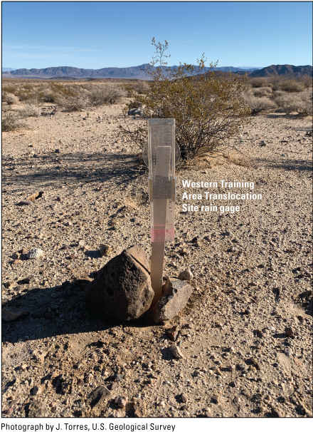
Rain gauges were randomly placed throughout the landscape to capture supplementary precipitation data. Gauges contain mineral oil to slow evaporation of precipitation and antifreeze to prevent freezing of precipitation.
Annual and perennial vegetation monitoring through field sampling efforts and remote sensing capture localized vegetation information that can be related to tortoise landscape use. Forage availability for tortoises can be sampled by recording each species, phenology, and biomass of available annual and select perennial forage plants within quadrats (1 square meter [m2] in size), while identifying and recording land cover strata (for example, upland, wash, rocky slope, and dry lake) at selected random points (Elzinga and others, 1998) within the WTATS. Sampling is most effective in spring and fall when tortoises are active and annual plant growth is expected. Our experience suggests that a robust design includes recording all species of live forage plants and their phenology within each quadrat. Available biomass can be obtained within a 0.1-m2 section of each quadrat by clipping all live forage plants at ground level for collection. Clipped biomass samples are then sorted into monitored plant functional groups (for example, native grasses, invasive grasses, native forbs, and invasive forbs) and weighed, both freshly clipped and dried, to quantify plant water content.
Perennial plants provide essential cover resources for tortoises in the Mojave Desert (Nussear and Tuberville, 2014). Our experience suggests a defensible design to conduct perennial vegetation sampling within the WTATS. Points within each site are randomly stratified and selected for repeated sampling over years. Perennial sampling will be done once per year at independently selected random points and randomly generated transect azimuths (Elzinga and others, 1998). To quantify cover and characterize the communities of perennials present at each site, line-intercept data are recorded along the 50-m transect. Along each transect, observers record the species of each individual shrub that intersects the transect as well as the beginning and end marks (in centimeters [cm]) of that shrub’s canopy along the transect (Elzinga and others, 1998). Height is recorded for each shrub encountered along the transect. Within belt transects, observers record the number of individuals of each perennial species rooted within the belt. Data collection from remotely sensed enhanced vegetation indices (EVI) from the Moderate Resolution Imaging Spectroradiometer satellite-based sensor and Unmanned Aerial Vehicle-based sensors may improve analysis and evaluation of tortoise habitat quality at a finer resolution.
Introducing juvenile desert tortoises into translocation areas as part of the experimental design as biological probes can benefit this endeavor greatly (Nafus and others, 2017a). Juvenile tortoises have greater sensitivity (growth and survival rates and health responses) to disturbances, resulting in larger and more detectable responses to treatment effects than adult tortoises (Drake and others, 2016). In cooperation with the BLM, a defined investment in habitat improvements can be implemented to study habitat quality and effects of restoration efforts in augmented areas.
Roads, Habitat Fragmentation, and Human Effects
The NTC has invested in habitat improvements related to habitat restoration and roads in coordination with the BLM. Further investment in this commitment to intensive management actions could increase the success of this translocation in an area that is open to the public. Research on the effects of roads and other disturbances on tortoises and their habitats is recommended by the Recovery Plan (U.S. Fish and Wildlife Service, 2011). Downward population trends of Mojave Desert tortoises can be directly or indirectly linked to presence of roads, habitat fragmentation, and other assorted anthropogenic threats across the range (Stebbins, 1974; Bury and others, 1977; Boarman, 2002a; Tracy and others, 2004; Custer and others, 2017; Allison and McLuckie, 2018; Dutcher and others, 2020; U.S. Fish and Wildlife Service, 2021b; Averill-Murray and Allison, 2023). Road presence may decrease tortoise populations through various mechanisms, including direct mortality from vehicle collisions, which reduces the number of larger reproductive animals that could contribute to population recruitment (Nafus and others, 2013). Furthermore, roads across the Mojave Desert increase access to desert tortoise habitat and can introduce other human effects, such as introduction and invasion of non-native plants and exposure to predation by feral dogs (U.S. Fish and Wildlife Service, 2021b).
The number of paved and unpaved roads and OHV routes, as well as off-road vehicle use and habitat degradation, have increased in the Mojave Desert, including in the WTATS (Tracy and others, 2004). Human development, including renewable energy, continues to expand throughout the Mojave Desert (Agha and others, 2020). A recent study indicated that 60–70 percent of tortoise habitat had human development within 1 km, and 43 percent of undeveloped tortoise habitat was outside of current Federal, State, or local habitat protections (Carter and others, 2020). Cumulatively, these effects will encourage the success of the translocations; however, well-coordinated conservation management actions could be taken to increase the likelihood of translocation success.
Many metrics can be used to evaluate landscape patterns. Spatial pattern analysis may consider area, density, or edge, shape, core area, isolation or proximity, contrast, contagion or interspersion, connectivity, and diversity (McGarigal and others, 2002). In addition, linear network pattern analysis may be useful with development of a variety of other metrics (Forman, 1995). Measurement of road density may be used as a surrogate for fragmentation. Road density can be measured by the number of miles or kilometers of roads and trails per unit area.
A long-term analysis from the Mojave Desert Tortoise Recovery Office found that no tortoise populations increased in areas with road density greater than 0.75 km/km2 (Averill-Murray and Allison, 2023); Averill-Murray and Allison (2023) recommended management actions to reduce tortoise declines relative to road density, including increasing law enforcement, public outreach, and tortoise-exclusion fencing, as well as setting limits for road density (through communication and efforts between BLM and NTC). The DOD will fund BLM contact park rangers to patrol focal areas, described in the USFWS Biological Opinion (U.S. Fish and Wildlife Service, 2021a), to increase BLM presence and monitor for illegal activities (U.S. Fish and Wildlife Service, 2021a). Mean patch size, number of patches, edge density, and landscape shape index related to road networks can also be measured and may be correlated with changes in the composition of native perennial plant communities and relative presence of exotic and native annual plants, which may affect tortoise diets (Oftedal and others, 2002; Drake and others, 2016). Designating closed OHV wash zones throughout the area may reduce effects to suitable tortoise habitat. Current Federal OHV policy and regulations have shown positive effects of reasonable compliance on sensitive habitats when open versus closed routes were clearly marked (Custer and others, 2017), but other areas have experienced low compliance with road closures (Ouren and others, 2007).
As part of the Recovery and Sustainment Partnership Initiative and Recovery Plan Strategic Element 2 (U.S. Fish and Wildlife Service, 2021a), the NTC will work with the USFWS to protect existing tortoise habitat by providing funding for the acquisition and conservation of private inholdings on the recipient site landscape (WTATS), particularly in areas where rapid reduction of fragmented habitat and management may be possible. The Recovery Plan (U.S. Fish and Wildlife Service, 2011) recommends management by working to connect blocks of desert tortoise habitat to maintain gene flow between populations, with priority conservation areas chosen based on minimum connection of habitat needed for desert tortoise long-term success (Averill-Murray and Hagerty, 2014; Averill-Murray and others, 2021). Habitat restoration activities focused on unauthorized routes may reduce human use of these areas. Activities such as developing seed sources of native plant materials and removal of invasive plant species may contribute to long-term success of tortoise populations and other wildlife (Olwell and Riibe, 2016; Esque and others, 2021a). Reducing the use of unauthorized routes through fencing would allow for future restoration efforts and reducing tortoise mortalities from vehicle collisions.
As part of long-term success metrics, the NTC can monitor translocated, resident, and reference tortoises throughout the WTATS, which has varying levels of habitat disturbance, including on BLM and DOD lands; therefore, data will be available to study the effects of roads and habitat fragmentation on tortoise populations. The DOD will support the BLM to reduce route density (U.S. Fish and Wildlife Service, 2021a) within the translocation areas to achieve a level of greater than 0.75 km/km2 as per Averill-Murray and Allison (2023), including through road closures and restoration.
Short-Term Metrics: Success Criteria Stages 1-3a
Short-term metrics for the evaluation of translocation success will include, but are not limited to, fine (daily or weekly) and coarse (monthly, inter-annually, and decadal) analyses of tortoise movements, site fidelity, home range size and variation through time, egg production, nest survival, recruitment, growth rates, stress, disease, and survival rates. Short-term monitoring is done during the first 6 years of the translocation project, including the year tortoises are moved (table 9; app. 1), and includes three stages (stages 1, 2, and 3a, table 9). An interim report completed on year 5 post-translocation that summarizes the results of the short-term monitoring program would be valuable. This report and associated coordination meetings with USFWS and other potential cooperators may inform adjustments for the long-term monitoring program or other remedial or adaptive-management activities that need to take place in the interim.
Movement, Site Fidelity, and Home Range
The analysis of animal movements provides a quantitative measure that can be used to relate desert tortoise population status to variation in their habitats. Movement and space use by animals can be analyzed by repeatedly recording locations using radio telemetry or satellite tracking techniques. Tortoise movement may vary in response to disturbances (for example, new roads or other features introduced by construction), social interactions (for example, translocation or recent arrival of other translocated tortoises), natural landscape features (for example, habitat and anthropogenic barriers), sex, age/size, season, environmental conditions (temperature and precipitation), reproductive status, or the availability of forage, water, and shelter (Nussear and others, 2012; Esque and others, 2014; Farnsworth and others, 2015; Todd and others, 2016; Nafus and others, 2017b; Averill-Murray and others, 2020; Dutcher and others, 2020; Hromada and others, 2020, 2023). Translocated and recipient tortoises can be expected to shift in relation to these factors for as many as 3 years (Nussear and others, 2012; Farnsworth and others, 2015).
The best way to evaluate translocation success may be to quantify when they “settle” into stable home ranges. Movements can be analyzed using many methods (Turchin, 1998; Doerr and Doerr, 2004; Fleming and others, 2016; Patterson and others, 2017; Averill-Murray and others, 2020): maximum tortoise distance displacement, the net distance displaced, the cumulative distance displaced, and the meander-ratio of movements over time have been used to describe movements of translocated tortoises (Turchin, 1998; Field, 1999; Doerr and Doerr, 2004; Nussear and others, 2012; Farnsworth and others, 2015; Fleming and others, 2016; Patterson and others, 2017; Averill-Murray and others, 2020). Movement analyses can be used to inform managers about tortoise habitat and resource selection, spatial use patterns, and areas of concern for conservation (Hromada and others, 2020; Nafus and others, 2022).
Animal movements are classified according to their timing, seasonality, repeatability, and associated behaviors. Assessing home range is important in understanding desert tortoise ecology (Burt, 1943; Woodbury and Hardy, 1948, Berish and Medica, 2014). Previous translocation studies have indicated that tortoises moved to atypical habitat are less likely to establish home ranges and demonstrate site fidelity than tortoises moved to areas known to be desert tortoise habitat (Nussear and others, 2012). In addition, home ranges may be affected by seasonal vegetation availability (U.S. Fish and Wildlife Service, 1994; Nafus and others, 2017b). We expect that desert tortoises translocated to most of the proposed recipient sites will establish home ranges in the short-term because every proposed recipient site has resident tortoises, thereby demonstrating that they are within suitable habitat. It is expected that translocated tortoises will establish a home range and show site fidelity similar to that of reference tortoises in the field by year 3 after release.
Home range can be calculated using several methods (Worton, 1987; O’Connor and others, 1994; Seaman and Powell, 1996); however, sample size, smoothing parameters, and sampling regime introduce unknown bias among estimators (Kazmaier and others, 2002; Harless and others, 2010; Noonan and others, 2019), making estimates among multiple methods volatile (O’Connor and others, 1994) and difficult to compare statistically. Home range estimation methods developed in the past 10 years, such as AKDE, can alleviate assumption violations identified for previous methods and produce more accurate home range size estimates (Noonan and others, 2019; Averill-Murray and others, 2020). Autocorrelated kernel density estimation accounts for autocorrelation in animal tracking data, small effective sample size biases, irregular sampling, and telemetry error (Fleming and others, 2018; Averill-Murray and others, 2020). The home range concept assumes that animals are not dispersing (Burt, 1943), and the comparison of movements by tortoises in the first 3 years of translocation compared to home ranges after that time (when home ranges are relatively stabilized in the area used) can be used to indicate how well the tortoises have responded to the translocation through the long-term duration of the program (via semivariograms).
The NTC acquisition of locational data can be used to determine movement patterns of recently translocated tortoises to be used in movement and home range analyses. Acquisition of movement and home range data can be achieved through routine monitoring of all translocated, 75–100 resident, and 75–100 reference tortoises through VHF telemetry or GPS data-loggers (i-gotU, model GT-500, Mobile Action, or similar). A less than 20-percent difference in movement between translocated and recipient populations by year 4 of monitoring post-translocation would meet success criteria for this metric.
Egg Production and Nest Success
Important components of tortoise population recruitment can be measured by successful egg production, survival of hatchling tortoises, and growth into larger size classes (U.S. Fish and Wildlife Service, 2011; Campbell and others, 2015). Previous research on tortoise recruitment at the NTC indicated a lack of recruitment into reproductive stages, resulting in low fecundity. Research hypothesized that low fecundity would result in reduced genetic variation (as many as approximately 3 percent reduction in gene diversity with population separation maintained for 500 years) and increasing inbreeding coefficient (approximately 2-percent increase with population separation maintained for 500 years) (Mulder and others, 2017). Nest success is a variable that can be used to measure the success of translocated populations assimilating into the recipient population and to predict their potential effect on recipient site demographic patterns. In addition, reproductive success may indicate if physiological stressors (for example, precipitation, forage availability, stress, and disease) are affecting tortoises at an ecological level (Lovich and others, 2015; Mitchell and others, 2021a). Egg production and oviposition are affected by precipitation and spring temperature extremes (Turner, 1982; Averill-Murray and others, 1996; Mitchell and others, 2021a). Consequently, egg production may be a measure of environmental effects and ecological performance that can be important indicators of translocation success. X-radiography has been used to determine clutch size and frequency in turtles and tortoises for approximately 40 years and is not thought to place adult tortoises, embryos, or populations in jeopardy; however, further research into the long-term effects of this activity is still required (Hinton and others, 1997). Egg production is measured by taking X-rays of an experimental population of female tortoises in the field every 2 weeks (Turner and others, 1986; Henen, 1997; Nussear, 2004). In addition, ultrasonography can be done in the fall to document the development of yolk follicles (Kuchling, 1989; Rostal and others, 1994) and to reduce the need for extra X-rays in the spring. The NTC monitoring of egg production of tortoises among all study groups would help to determine factors that may affect fecundity and growth among translocated, recipient, and reference tortoise populations.
The second component of measuring reproductive success is identifying the proportion of eggs that produce hatchling tortoises emerging from nests. Tortoise nests can have a high incidence of predation (Bjurlin, 2001; Franks, 2002). Predation rates may be higher in areas where there are greater predator densities (Bjurlin, 2001) because predator and prey species’ abundances vary, or where appropriate nesting substrates are not adequately available. Tortoise nests can be found by using fluorescing powder on gravid females with hard shelled eggs (as determined using X-rays) and following powder trails created to the nest (Keller, 1993) or by attaching GPS loggers or thread trailers to gravid female tortoises near the time when shells form on the eggs (Bjurlin, 2001). Increased monitoring and care for gravid females ensures tortoises are not entangled by attached threads if this method is used. Once nests are located, they can be monitored for hatchling success and nest predation (Bjurlin, 2001). Nests may be caged to protect them from predators if necessary (Turner and others, 1986). In addition, maintaining egg orientation in nests promotes embryo survival (Ewert, 1979). Minimizing the number of times that a nest is visited may be beneficial in reducing the number of nests that are depredated. Less intrusive methods, such as installation of camera traps near nest sites to monitor nest use, including by predators, reduce the possible effects on tortoise nests. Transfer of human scent to nest sites is minimized by using ground covering for sitting and equipment and altering daily tracking routes to nests.
To assess tortoise reproduction and nest success in the release areas post-translocation, we suggest the NTC monitor 20 female tortoises from each study group for egg production by doing X-rays on each individual. X-rays are best taken every 2 weeks from mid-April through mid-June for at least 3–5 years. Once any of the 20 females are found to be gravid and with shells forming on the eggs using X-rays, they can be equipped with GPS loggers, fluorescing powder, or thread trailers to locate nests. Detected nests can be fenced and monitored by camera traps to follow all nest activity, including laying of eggs, potential predation or other disturbances, and nest emergence of neonates. Camera captures are best inspected daily for at least 3 weeks after the last neonate emerges. Every neonate can be weighed within 24 hours of emergence, equipped with small transmitters (not exceeding 10 percent of body weight), and tracked every 3 days to monitor health and survival. Any hatchlings or juveniles found on the landscape can be monitored for success rates. Egg production, nest success, survival, and size class recruitment among tortoise study groups that does not differ by more than 20 percent from the reference tortoises would indicate translocation success based on this metric.
Growth Rates
Growth rates of vertebrates are highly variable and can be affected by environmental conditions, nutrition, health, sex, and age (Turner and others, 1984, 1987; Nagy and others, 2020). Even healthy tortoises may have little or no growth in some years from lack of resources or because of resource expenditures. Growth rates also vary between adult male and female tortoises (Turner and others, 1987); although growth of males slows with age, adult reproductive females essentially stop growing and instead may redistribute most of their somatic growth potential into egg production (Medica and others, 2012). Growth rates can be measured by recording dimensions of the shell and the mass of animals over time (Woodbury and Hardy, 1948; Turner and others, 1987). Mass measurements are important but can be confounded by hydration status of the tortoise. Tortoises that have consumed water recently gain a lot of weight. Alternatively, tortoises can be dehydrated, a condition that can be lethal, and thus, mass measurements can be used to assess the condition of tortoises during monitoring. Measurements of growth are primarily evaluated based on plastron and carapace length.
Differences in growth will be difficult to detect among adult tortoises because of their slow growth rates (Medica and others, 2012). Therefore, estimating growth of pre-reproductive animals, or those generally less than or equal to 180 MCL, is more informative than estimating adult growth (Germano, 1994). Using growth as a success criterion requires captures (once during spring and fall) to estimate growth (Turner and others, 1987). Growth monitoring is done across study groups (reference, resident, translocated) to adequately document and changes in growth over time. Using growth as a success criterion requires that small size classes of tortoises be translocated in addition to adults to detect differences in growth rates among study groups. Growth of small tortoises can be correlated with precipitation (Berry, 2002; Nagy and others, 2015b; Nafus and others, 2017b) and nutrition (Drake and others, 2016; Nagy and others, 2020). Thus, evaluating tortoise growth success requires the comparison of growth among smaller reference, resident, and translocated tortoises while also considering the environmental conditions among years and sites. This information will result in seasonal and annualized growth estimates among tortoises by sex and size (age).
Precipitation and forage availability data (according to methods mentioned in the “Measurements of Environmental Variables” section), in addition to tortoise measurements taken twice per year (spring and fall), can be used to identify the growth rate of all recently translocated tortoises in comparison to 75–100 resident and 75–100 reference tortoises in existing environmental conditions. After accounting for age, sex, and variation among sites in the amount of annual rainfall, forage availability, and other relevant factors, we predict growth rates of individual tortoises will not vary by more than 20 percent among study groups after the first 3 years post-translocation. In this case, translocation can be considered a success with respect to this metric. If growth rates vary more than 20 percent during the first 3 years post-translocation, then potential causes for differences may be investigated.
Disease, Stress, and Survival Rates
Mycoplasma agassizii and Mycoplasma testudineum are common bacteria detected in tortoises and are pathogens that play an important role in URTD (Brown and others, 1994, 1999; Jacobson and others, 2012; Drake and others, 2017). Testudinid herpesvirus (Origgi and others, 2002) also has been detected in tortoises with respiratory disease; however, the significance of this virus to tortoise survival is still unknown (Jacobson and others, 2012; Burgess and others, 2021). Periodic tissue samples for analysis can be used to monitor the incidence of disease in translocated, resident, and reference populations, as described in the “Tortoise Health Assessments, Tissue Sampling, and Laboratory Diagnostics” section.
Samples collected from tortoises during routine health assessments will be screened for the various pathogens that cause URTD and TeHV2 (U.S. Fish and Wildlife Service, 2020). Screening for other diseases could be done if definitive laboratory assays become available and the USFWS deems it necessary. Tortoises infected with Mycoplasma may take as many as 2 years to develop a positive ELISA result (Aiello and others, 2019; Drake and others, 2019). Health assessments (blood samples, oral swabs, and physical assessments) completed annually (either in spring or fall) on each experimental group during the first 5 years after translocation will compile a solid baseline of health status for long-term monitoring comparison. These assessments will be completed following protocols in “Health Assessment Procedures for the Desert Tortoise (Gopherus agassizii)—A Handbook Pertinent to Translocation” (U.S. Fish and Wildlife Service, 2019, 2020; see the “Tortoise Health Assessments, Tissue Sampling, and Laboratory Diagnostics” section). Some disease exposure or transmission between translocated and resident tortoises is possible because of tortoise dispersal, change in tortoise contact frequency, and altered community network structure (Aiello and others, 2014, 2018); however, the levels of disease in the translocated and recipient populations are not expected to differ greatly from the reference population in the short-term. Tortoises that tested positive for Mycoplasma antibodies were successfully maintained for more than 10 years at the Desert Tortoise Conservation Center in Las Vegas, Nevada, and they produced the same number of eggs and clutch sizes as reference animals in a captive tortoise study (Rostal and others, 2001).
Recovery objectives in the Desert Tortoise Recovery Plan include measurable and objective documentation of tortoise demography, distribution, and habitat (U.S. Fish and Wildlife Service, 2011). One baseline population measurement required to model demography is tortoise survival rate. Survival rates are evaluated by quantifying survival or mortality over time by periodically monitoring marked individuals (for example, monthly, and annually, or longer intervals). Survival rates may depend on weather conditions that vary annually (Turner and others, 1984; Peterson, 1994), vary cumulatively across years as climate varies (Longshore and others, 2003), or are implicated as indirect threats to tortoises like predation (Esque and others, 2010). Tortoises will be rehydrated monthly during the summer if precipitation from fall to spring is one standard deviation from the 30-year average for precipitation in the study area. Precipitation data collected from weather stations and rain gauges can be analyzed annually to determine necessary actions (in coordination with USFWS) to minimize tortoise mortality due to drought.
Survival rates may also depend on the incidence of disease or other stressors, such as habitat disturbance covered earlier in the text. In addition to annual responses to environmental conditions, survival among different populations may depend on long-term site conditions that vary spatially. Although it can be assumed that survival rates vary from place to place, empirical data to determine the mechanisms causing such patterns are rarely acquired.
Disease levels, stress levels, predation, and survival varying less than 20 percent among translocated, resident, and control populations indicate translocation success for these metrics. If disease, stress, or survival rates for translocated animals vary more than 20 percent from those of residents or controls in similar conditions, then the apparent causes can be investigated so that adaptive management of the translocation program can potentially mitigate any identified problems.
Predation
Survival and mortality rates in desert tortoise populations can be highly variable (Turner and others, 1984; Peterson, 1994). Comparing the mortality of all study groups with similar conditions allow evaluation of the relative success of a translocation (Esque and others, 2010). Drought, predation from ravens and mammalian carnivores, and human related activities (OHV and road kills) may be the proximate causes of mortality in tortoises throughout the project area (U.S. Fish and Wildlife Service, 1994, 2011; Tracy and others, 2004). Ravens are known predators of tortoises and use transmission lines as nesting sites. These lines provide ravens opportunities to expand their range in areas that may not have been historically accessible (Boarman, 2002b; Kristan and Boarman, 2003; Boarman and others, 2006; U.S. Fish and Wildlife Service, 2011; Xiong, 2020). Management actions in relation to raven populations (for example, egg oiling and physical/lethal removement of predators) throughout the Desert Tortoise Critical Habitat Units have attempted to reduce predation on desert tortoises (Boarman, 2003; Xiong, 2020; Currylow and others, 2021; Sanchez and others, 2021). Foxes, coyotes, and badgers also are predators that prey on tortoises across size classes (Turner and others, 1984; Esque and others, 2010; Emblidge and others, 2015). Comparing mortality rates of translocated tortoises with resident and reference populations in similar habitats but with different predation pressures can elucidate underlying causes. This approach was used at the NTC after the first translocation to explain how predation by subsidized predators within the first year after translocation was not directly related to the actual translocation but instead reflected a range-wide phenomenon that was attributed to proximity to areas of higher density human populations (Esque and others, 2010). Sustainable populations of desert tortoises in a population represented by those greater than 180 MCL have annual mortality rates of less than 2 percent during average environmental conditions (Turner and Berry, 1984).
Predation events can be documented to inform a predation plan to identify triggers for management actions to be considered if greater than 2 percent of the study populations are lost to predation in each season (spring, summer, fall, winter). Experimentation on methods of predation control or deterrence that start at the onset of the translocation work, and before acute predation problems, can provide management responses in advance. Investments include consultation and partnership with an assembly of mammalian carnivore (coyotes and badgers) experts and biologists to design methods of predator control and study their ecology in the western Mojave Desert. Permit terms typically require all tortoise mortalities (including study animals and fresh incidental animals) to be reported immediately to the Desert Tortoise Recovery coordinator by phone or email within 24 hours and within 3 working days to the Pacific Southwest Regional Recovery Permit Coordinator (number TE-63428D-0, -1). A detailed report of the injury, mortality event, and carcass is typically submitted to the Desert Tortoise Recovery Coordinator and included in the annual reports (number TE-63428D-0, -1). Such planning may avoid an ineffective crisis response in the event of high predation activities.
Long-Term Metrics: Success Criteria Stages 3b-5
Long-term monitoring and research projects described in this section will be executed and administered by Fort Irwin using operational funds, Recovery and Sustainment Partnership Initiative (RASP) program funding, or through other appropriate funding sources. Long-term measures of success are evaluated differently from short-term measures. For short-term measures of success, the focus is on ensuring with some certainty that undue harm was not caused to the translocated or resident populations as measured by multiple correlates of fitness. Furthermore, if there are issues for which the success criteria are not met, then adaptive management will be implemented in a timely fashion to mitigate whatever issues arise and to inform subsequent desert tortoise management. Long-term metrics for evaluating success will assist in understanding the effects of translocation on desert tortoises by expanding on short-term quantification of fitness correlates. This work will include demographic parameters such as reproduction (genetics), recruitment, and survivorship (diseases).
Long-term monitoring of at least 30 years, in excess of a tortoise generation (for example, as many as 25 years), is valuable because recruitment and growth rates can be variable (Medica and others, 2012; Nafus and others, 2017b; U.S. Fish and Wildlife Service, 2020). Long-term metrics can be measured by (1) less intensive radio telemetry monitoring of animals (in the three study groups) over longer periods of time than wild tortoises in this research design have been previously monitored and (2) more intensive surveys of the recipient sites and surrounding areas (at minimum) to continue to gather comparative data among tortoise study groups and their habitats during at least one tortoise generation. We suggest monitoring a subset of 100 tortoises per study group that is stratified by sex and age class ratio using findings from baseline demographics (see the “Baseline Tortoise Investigations [2020–22]” section) and by recipient site (two males to one female to one subadult/unknown sex; two adults to one juvenile) for years 9–30 post-translocation (stages 3b, 4, 5, and 6; table 9). Such a subset would be representative of the overall study group (sex, age-class, and distribution). The sample size would best be based on a power analysis to ensure that the probability of detecting a difference is at least 80 percent (Lachin and Foulkes, 1986). Biennial mark-recapture surveys on defined survey plots for the translocated, resident, and reference tortoises are to be done during the fall season to evaluate the long-term metrics of success for the remainder of the 30-year post-translocation monitoring period and to refresh (by adding individuals to maintain adequate sample size) sample sizes of resident and reference populations (U.S. Fish and Wildlife Service, 2020). During population surveys, health assessments may also be done for any tortoises that are observed or processed. Throughout the long-term monitoring of tortoises, data on tortoise demographics, reproduction, genetics, survivorship, disease, and habitat quality can be collected using guidance provided in the upcoming text to aid in the interpretation of the long-term success of this proposed translocation and probability of success for future tortoise translocations.
Demographic Surveys
Demography is the study of how population characteristics vary through time and across space. Having information about population demographics is fundamental to species management, and the Recovery Plan emphasizes this need by calling for analysis of key vital rates through long-term, range-wide demographic monitoring (U.S. Fish and Wildlife Service, 2011). Demographic parameters of interest include population densities and size, growth, range, size class distributions, and vital statistics, such as generation time, reproductive rates, recruitment rates (in other words, rates at which individuals transition from one size class to another or move among populations), and survival and mortality rates (Gotelli, 2008). Tortoise demographics have been monitored in two primary ways: (1) permanent study plots (PSPs; 1 mi2 in area) and (2) distance sampling (Buckland and others, 2001). Permanent study plots were established across the range in the 1970s (Berry and Nicholson, 1984; Corn, 1994; Tracy and others, 2004; Farwell and Wallace, 2021). After Federal protection for the tortoise, those study plots were mostly replaced by line-distance sampling to estimate population density trends (Anderson and others, 2001; Allison and McLuckie, 2018). Desert tortoise populations have low potential population growth rates because the harsh desert environment they inhabit provides few resources and leads to slow growth rates (Woodbury and Hardy, 1948). For decades, populations have been declining and lower probabilities of occupancy have been documented (Doak and others, 1994; Inman and others, 2009; Allison and McLuckie, 2018; Kissel and others, 2023); however, sampling methods have varied across the range and through time, resulting in variation in population growth rate estimates and densities (Tracy and others, 2004; Inman and others, 2009; Mitchell and others, 2021b).
Comparisons of the population demographics among study groups can aid in evaluating the success of this and other large translocations. The long-term monitoring program is designed to integrate the demographic parameters. Long-term post-translocation studies may help the NTC to understand different aspects of tortoise demographics. Distance sampling methods, continued as part of the long-running USFWS recovery monitoring program, track trends in population densities, whereas permanent study plots provide life history statistics and can be used to evaluate the contribution of translocated tortoises to recipient populations. New plots for demographic studies can be established in a spatially explicit capture-recapture framework (Royle and others, 2014). This approach recently has been published for desert tortoise research in Nevada and California (Mitchell and others, 2021b). Permanent study plots require 100-percent study-area coverage on mark-recapture surveys (1-km2 plots) for 3 consecutive days (Mitchell and others, 2021b). Permanent locations of demography plots are best determined after short-term movement and home range analyses have been completed. Plots would best be in areas where translocated tortoises have settled to optimize their relevance to this project in coordination with USFWS. Any new PSPs can be incorporated into the network of previously established demographic plots. Data on sex-specific survivorship, reproductive success, parental contributions or genetics, juvenile recruitment, and transitions among age classes (for example, egg, hatchling, juvenile, and reproductive adult) can be gathered from these demographic plots. Improved demographic models using this combination of techniques may inform managers of tortoise population responses to translocation and restoration efforts and how best to manage and identify potential threats (Tracy and others, 2004; U.S. Fish and Wildlife Service, 2011; Mitchell and others, 2021b). Field and analytical methods can be updated based on new application of these methods to desert tortoise demography questions in coordination with USFWS.
Finally, locating and following desert tortoises with a carapace length of less than 180 mm through time can be challenging, so they are understudied. Specifically, studies are needed to evaluate whether these tortoises are rarer on the landscape or simply more cryptic. Knowledge regarding how small tortoise abundance changes over time also is needed. Minimally, understanding the role of tortoises less than 180-mm MCL would likely require intensive surveys of the recipient sites and surrounding areas to determine differences among translocated, resident, and reference populations. Size distributions and other demographic data may be linked to reproductive output and parental contributions among study groups.
Reproduction and Recruitment
Long-term monitoring of tortoise reproduction and recruitment is critical to understanding translocation success for desert tortoises because of their longevity and low population growth rates (Turner and others, 1987; Tracy and Tracy, 1995; Medica and others, 2012). The USFWS provides guidelines that specify monitoring of tortoise reproduction in the short- and long-term (at least 9–18 years) after translocation (table 9; U.S. Fish and Wildlife Service, 2020). Post-translocation assessment of tortoise reproduction includes assessment of reproductive output among study groups and evaluating if the juvenile segment of the size-class distribution is increasing (table 9). Methods to determine tortoise reproduction and recruitment success, including through evaluating tortoise egg production, survival of hatchling tortoises, and growth into larger size classes, are the same for long-term and short-term monitoring (see the “Egg Production and Nest Success” section).
By continuing to monitor 20 translocated females, 20 resident females, and 20 control females, the NTC can augment tortoise reproduction information collected during the short-term post-translocation monitoring period. X-rays are used to identify clutch size (number of eggs) because finding and monitoring tortoise nests can be difficult. X-rays can be taken of each individual yearly in the spring, and nesting behavior and activity can be closely monitored upon identifying gravid females. In addition, tortoise demographic surveys completed once every 2 years can detect as many tortoises of all size classes as possible, including those less than 180-MCL, to provide insight on size class distribution and recruitment of juveniles into the larger tortoise population.
Genetic Integration
Understanding the genetics of desert tortoise populations can inform translocation research in important ways. Primarily, understanding if translocated tortoises can meaningfully contribute to these augmented populations by becoming reproductively integrated and increasing population growth is needed. Little is known about the effects of translocating tortoises to augment populations. Genetic contribution (male and female) from translocated tortoises to resident tortoises and the time it takes for translocated populations to assimilate into the resident population are important to understand for long-term conservation of the tortoise. Parts of such a study were completed after the first NTC Fort Irwin translocation in 2008 (Mulder and others, 2017). The short-term results indicated that translocated males had lower fitness than residents because there was no genetic evidence that offspring of translocated males were integrating into the population. However, mean clutch size and contribution from translocated female tortoises were similar to that of resident females. This study was done after the fourth year of translocation; therefore, it may not represent full potential for genetic contributions during the long-term integration of translocated desert tortoises (Mulder and others, 2017). It is especially important to quantify these relationships in relation to the background dynamics in desert tortoise populations that are not manipulated for comparison. Little data on relatedness within small geographic areas are available at this time.
Genetic integration among translocated and resident tortoises is a metric for success that can be evaluated by the presence of juvenile tortoises of mixed parental ancestry among the study groups. This criterion can be measured by comparisons of unique alleles found in the offspring in the population and adult tortoises in the study groups through time. For example, if alleles that are unique to the translocated tortoises (compared to the resident and reference populations) are found in young tortoises that were not in the translocation cohort, then this metric demonstrates that the translocated tortoises are contributing reproductively to future generations of tortoises. Other parameters that can assist in understanding the effect of translocation on populations include effective population sizes (Ne), effective number of breeders (Nb), neighborhood size (NS), allelic diversity (Ar), and migration rates as evaluated in other wildlife population genetic studies (Vandergast and others, 2019). These and other metrics can be explored to provide evidence of the integration of translocated tortoises into recipient populations, connectivity among populations, and how augmentation affects population dynamics.
Genetic connectivity within and among tortoise populations can be assessed by genetic analyses and has become an important research and management topic in recent years because urban development, habitat fragmentation, and impenetrable barriers, such as roads or large burned areas, and other disturbances can impede gene flow (Storfer and others, 2007; Hagerty and others, 2011; Dutcher and others, 2020; Averill-Murray and others, 2021). The Revised Recovery Plan (U.S. Fish and Wildlife Service, 2011) focuses on determining the effect of corridors and barriers on tortoise distribution and gene flow (Recovery Action 5.5; U.S. Fish and Wildlife Service, 2011). These questions also are relevant at the NTC; the WTATS is split into east and west sections because of tortoise-proofed fencing along Fort Irwin Road, which unequivocally impedes genetic connectivity (fig. 6; Latch and others, 2011; Dutcher and others, 2020). Translocation of tortoises may increase genetic diversity in this area; however, for long-lived species, multi-generational sampling is needed to observe first-order relatives (full siblings or parents and offspring) and evidence of connectivity (Vandergast and others, 2019; Dutcher and others, 2020; Larson and others, 2021).
The NTC can use tissue samples already archived while doing health assessments on tortoises from the WTA and WTATS as part of their baseline genetic evaluation. Furthermore, desert tortoises that were involved in the previous translocation (Esque and others, 2005, 2009) could be especially useful in tracking the genetic patterns in the populations because they had more than 15 years to assimilate into the population. Samples are archived for those among various research groups that worked on prior translocation in the area.
Blood samples taken from all the study groups, including before and after recruitment, samples collected during short-term monitoring can be used in genetic analysis, and previous translocations can be useful in these genetic analysis (see the “Egg Production and Nest Success” section). Analyses of microsatellite markers found in tortoise nuclear DNA can be used to determine the amount of genetic variability that exists among animals from the WTA (before translocation) versus resident and reference animals in the WTATS. If significant genetic variation is not discernible among the samples from microsatellite markers (for example, mtDNA, NRY, and so on), then higher resolution genomic markers (for example, single nucleotide polymorphisms) may be required (Harrison, 1989; Ellegren and Galtier, 2016; Zimmerman and others, 2020). There may be more definitive analyses available to researchers in the future, and samples can be banked to use at that time.
Survivorship and Disease
Monitoring survivorship and disease presence or absence provides basic information toward understanding population demography and health and may be especially important when disturbances, such as translocation, are introduced into populations (Esque and others, 2009, 2010; Aiello and others, 2014; Brand and others, 2016; Mack and Berry, 2023). The Recovery Plan (sections 3.b.2 and 3.c, p. 54; U.S. Fish and Wildlife Service, 1994, 2011) recommends long-term research on survivorship and epidemiology and factors that contribute to mortality of desert tortoises, in addition to research on the long-term effect of translocation on population dynamics. Methods from short-term monitoring for disease, stress, survival rates, and predation can be continued to the long-term but at a lower monitoring effort.
Long-term survivorship and disease can be quantified by tracking a portion of tortoises among the study groups, to include all the tortoises previously sampled in the WTA and WTATS during pre-translocation activities. Added to those tracked will be tortoises registered on the demographic study plots (see the “Demographic Surveys” section), tortoises monitored among the translocation study groups, and tortoises from other survey and research efforts in the release areas, such as from line-distance sampling efforts as part of the USFWS’ long-term program to understand range-wide tortoise density trends (Allison and McLuckie, 2018). Cooperating with other tortoise monitoring efforts in the area (for example, universities or other Federal agencies may have tortoise monitoring programs in the surrounding area) can enhance efforts to understand long-term survivorship. Survivorship or mortality data collected on an ongoing basis with all the tortoises involved with the translocation can be tracked in the master database (see the “Reporting and Data Storage” section).
During health assessments for all tortoises associated with this translocation, tissue samples are collected and submitted for testing and archived. These samples are sent to laboratories and screened for pathogens that cause Myag, Myte, and TeHV2. If assays become available, other transmissible diseases may be screened (see the “Disease, Stress, and Survival Rates” section). It can take several months to years for tortoises to present with signs of disease and to yield pathogen presence or antibody responses to targeted pathogens (Aiello and others, 2019; Drake and others, 2019).
Continued tortoise disease screening as part of the long-term post-monitoring efforts is valuable. Any tortoise monitored as part of the translocation in the recipient and reference sites is best surveyed every 2 years over the long-term. Tortoises that were marked during previous NTC translocations can be especially useful in interpreting long-term survivorship and disease prevalence among groups of tortoises identified in the short-term. If survivorship and disease do not differ by more than 20 percent among the study groups, as measured over the long-term, then the translocation may be considered successful for this criterion (table 9; Esque and others, 2005; U.S. Fish and Wildlife Service, 2020). Additionally, study group survivorship can be compared with regional and large spatial scale datasets (when available) to evaluate management practices (for example, localized predation events).
Reporting and Data Storage
As required by the Biological Opinion (U.S. Fish and Wildlife Service, 2021a) and recovery permit (number TE-63428D-0, -1), the Army must provide electronic annual and comprehensive reports for all permitted activities by January 3, after each year the recovery permit is in effect. Reporting is an important aspect of the work to benefit desert tortoise recovery. Submission of the Annual Summary Report form (FWS Form 3-2530 or similar) and comprehensive project report will be provided to USFWS and will summarize all the desert tortoise, habitat, maps, health results, environmental data, and any additional information (for example, relevant GIS layers, master data sheets, photographs, notes) required by the USFWS recovery permit (number TE-63428D-0, -1). Datasheets and electronic data collection used in the field will be developed in coordination with USFWS and entered in a USFWS/BLM-provided master database (U.S. Fish and Wildlife Service, 2020). All desert tortoise, habitat, and environmental data may be archived in a standardized data repository such as ServCat or ScienceBase or an approved repository from USFWS, such that data collected will be open, machine-readable, secure, and accessible. Health data collection will conform to the current translocation health assessment guidance (U.S. Fish and Wildlife Service, 2020). All injuries and mortalities discovered during monitoring will be reported to the USFWS within 24 hours, per permit requirements (U.S. Fish and Wildlife Service, 2021a). The report must include the tortoise identification (ID), date, time, location of the carcass (UTMs), a photograph, cause of death (if known), and any other pertinent information (for example, sex, size, date, and UTMs of last known live location; U.S. Fish and Wildlife Service, 2021a).
After the completion of the short-term and long-term post-translocation monitoring periods, final reports are to be completed to assess the overall success of the translocation and monitoring program. The final reports will summarize translocation monitoring activities and other compliance-related reporting as specified in the Biological Opinion (U.S. Fish and Wildlife Service, 2021a). Completed recovery permit reports can include discussion of any adaptive management used throughout the monitoring period, with an assessment of the success of each adaptive management strategy. Reporting timelines and report content will be coordinated with USFWS guidance to ensure appropriate content is included per permit requirements (U.S. Fish and Wildlife Service, 2020).
Adaptive Management
This translocation plan describes procedures to plan, implement, and research translocation of tortoises by the NTC; however, adaptive management measures will be implemented during the translocation and monitoring processes after identifying concerns, immediately addressing issues in the field, and consulting with all involved agencies. Evidence of translocation project-related disturbance or increased risks to desert tortoises may necessitate discussions with the USFWS to outline these adaptive measures in translocation and monitoring procedures in additional or edited project documentation. Annual meetings between the NTC and USFWS, along with the post-translocation year 5 interim report, to assess compliance and implementation of the translocation plan may also drive remedial management actions for future study years. Altered management may be enacted in relation to the results of short-term and long-term tortoise translocation success metrics outlined in this section.
If there are concerns in the field regarding immediate threats to one or more tortoises, field staff can make adaptive management decisions in the best interest of the tortoise(s) through (1) coordination in the field; (2) phone calls to agency representatives within 24 hours to describe the actions taken and results of the actions; and (3) a brief email report from field staff that describes the adaptive management actions taken, along with reasons for and results of these actions. If there are concerns in the field that do not pose an immediate threat to one or more tortoises, a designated field representative can notify the agencies of proposed adaptive management decisions via email, and field personnel can wait as much as 1 week for consultation or additional direction and response from agency personnel before actions are taken. These adaptive measures can be taken by the NTC in addition to following minimum mitigation requirements outlined in the Biological Opinion (U.S. Fish and Wildlife Service, 2021a).
Triggers to implement adaptive management may include translocation activities that are projected to or have put the well-being of a tortoise at risk (for example, tortoises pacing a tortoise exclusionary fence, or a tortoise found within an active training area). After consultation with agency representatives, adaptive management measures may include, but are not limited to, the following:
-
• Altered translocation activity timelines, dependent on environmental and personnel variables (for example, staggered translocation of tortoises over more weeks or months).
-
• Construction of additional tortoise exclusionary fencing (temporary, if needed).
-
• Temporarily penning or blocking a tortoise in its burrow.
-
• Supplementary personnel and outreach education.
-
• Additional or altered vehicle escorts (pedestrian or vehicle).
-
• Decreased, postponed, or altered project speed limits or expansion.
-
• Increased monitoring of individual tortoises repeatedly observed in harm’s way.
-
• Predator management (for example, raven nest removals and coyote deterrence).
-
• Regional rehydration measures based on assessment or requested by the USFWS.
Summary
The U.S. Department of the Army (Army) plans to initiate military training exercises in a realistic battle environment within the National Training Center (NTC) and the Fort Irwin Western Training Area (WTA) in San Bernardino County, California, in 2025. Such large and intensive training activities would disturb desert tortoises and their habitats to the extent that translocation of tortoises would likely be required by the U.S. Fish and Wildlife Service (USFWS) before training ensues to minimize tortoise mortality.
The Fort Irwin Military Land Withdrawal Act of 2001 authorized the NTC to expand its training activities into Southern Expansion Area (SEA) and the Western Training Area (formerly known as the “Western Expansion Area,” or “WEA,” during the 2008 translocation). Translocation of tortoises from the SEA was completed in 2011. Planning for the SEA translocation sought to (1) provide safe, humane, and successful translocation of tortoises with minimal effect to resident tortoises and reference tortoises; (2) study tortoises affected by translocation to increase understanding of the ecology, conservation, and management of desert tortoises; and (3) define measures of success for translocation and provide metrics to evaluate successes. All activities supported by the NTC, as described in the 2008 Translocation Plan, were discontinued before completing the WEA (now WTA) expansion. Although monitoring for the 2008 NTC translocation ended prematurely, at least 37 peer-reviewed products on tortoise ecology, regional landscape conditions, and effects of translocation were published, thus partially meeting the original goals by increasing knowledge on tortoises, habitats, and translocation.
The WTA expansion and Western Training Area Translocation Site (WTATS) are the focus of this translocation plan. This plan describes how to monitor desert tortoise fitness compared with environmental variables to determine success metrics of translocation and identify thresholds for agency decision-making. This plan builds on the previous NTC translocation activities and includes results of recent (April 2020–November 2022) baseline surveys of tortoises and their habits in the WTA and WTATS, release areas, and reference areas. We identify tortoise locations in the WTA, evaluate habitat risks, provide choices for translocation and reference sites throughout the WTATS, and identify short- and long-term monitoring metrics for future surveys to evaluate the status of translocated tortoises in comparison with resident and reference populations.
The WTA (286 square kilometers [km2]) borders the Naval Air Weapons Station-China Lake (NAWSCL) to the north, the Paradise Range and Lane Mountain to the south, Superior Dry Lake to the west, and is in the southwest corner of the Fort Irwin NTC. Habitats are comprised of typical Mojave Desert shrubland with interior draining dry lakes. In the WTA, there is restricted access in the “East Paradise Conservation Area” and “Brinkman Wash Restricted Area.”
The WTATS (approximately 3,296 km2) is bounded on the north by the NAWSCL, WTA, and the NTC and is north of Barstow and Hinkley, in San Bernardino County, California.
Most of the WTATS is on public lands managed by the Bureau of Land Management (BLM), interspersed by private inholdings, and properties owned by the NTC. In addition to Mojave Desert shrublands, the WTATS has greater topographic diversity than the WTA by the addition of rugged volcanic and granitic mountains.
The staff at BLM Barstow and Ridgecrest Field Offices provided recommendations for areas to exclude as potential tortoise recipient sites in the WTATS due to land use conflicts, and they also indicated that translocated tortoises that move into designated Wilderness Areas from their recipient sites do not need to be removed.
Baseline tortoise and habitat investigations were performed in the WTA and the WTATS in 2020–22. A subset of tortoises had radio transmitters attached to their carapace so they could be located during future investigations. We established random tortoise survey plots (300 by 300 meters[m]) across the WTA and WTATS to estimate tortoise density and abundance following protocols adapted from the USFWS. There were 1,408 plots surveyed in the project area, and 783 tortoises were found. The 2020–22 plot surveys and telemetered tortoises included 783 tortoises, with 86 percent adults and a two male to one female sex ratio. Baseline tortoise health assessments were completed throughout the WTA and WTATS for telemetered tortoises. Tortoises were examined for clinical health conditions by physical assessment and tissue collection, following USFWS guidance. Collected samples were sent to labs to test for presence of tortoise diseases. Most health assessments classified the tortoises as “clinically normal” and “adequately conditioned.” Tissue samples from the WTATS yielded positive laboratory results either for antibodies specific to Mycoplasma agassizii and Mycoplasma testudineum (via enzyme-linked immunosorbent assay [ELISA] testing; n=4 or 3.3-percent of assessed population) or pathogen presence (via quantitative polymerase chain [qPCR] testing; n=6 or 6.7-percent of assessed population). There was 5-percent mortality among all marked tortoises averaged across the WTA and WTATS in 2020–22. Mortality analyses indicate only moderate losses from predation, disease, or climate variability in the project area, especially considering recent drought conditions.
One of the primary objectives of this translocation plan was to provide landscape analyses to inform the best locations for recipient and reference sites associated with the plan. Based on USFWS guidelines and consultations with partners, a model was created to inform site selection for recipient and reference sites related to the NTC translocation activities. The models identify suitable translocation sites for tortoises in the WTATS. Model parameters included biological, geospatial, and environmental data important to the survival and health of tortoise populations. The final seven modeling criteria for recipient site selection included: land ownership, desert tortoise habitat suitability, distance to roads, common raven nest site density, desert tortoise habitat connectivity, precipitation, and a terrestrial disturbance index.
Scenarios were developed using a form of ordered weighting averaging by manipulating the weight and scale of each input raster layer (criteria) that could be considered beneficial or detrimental to tortoise translocation in the WTATS. Spatial models providing desert tortoise habitat suitability, desert tortoise movement potential, and average winter precipitation were positive parameters, and negative effects included raven nest densities, distance to roads, and a total disturbance index. Potential scenarios for desert tortoise translocation success were based on the combination of five variations of the raster scaling. These scenarios were discussed with agency personnel with administrative responsibilities for the study area, who provided feedback in relation to agency policies.
In addition to combined modeling outputs, candidate sites for references sites were parcels owned by the NTC, are outside excluded habitats, have a suitability value greater than or equal to the mean model value (for example, greater than or equal to 0.39), and were considered as potential recipient sites for translocated tortoises from the WTA. Eight potential recipient sites and two potential reference areas were identified through the combined analyses. The recipient sites were ranked in order from highest to lowest priority. A 6.5-kilometer (km) movement buffer was created from the centroid of each selected Fort Irwin-owned land parcel (recipient sites), resulting in three potential translocation sites for translocated tortoises (TS1, TS2, TS3; may vary depending on exact release site of translocated tortoises).
Site visitations were made by authors of this report and other USGS staff members extensively from spring 2020 to fall 2022 for evaluation of recipient and reference sites. Recipient and reference sites or grouped sites were photographed at their centroids and digitally archived in fall 2022. We found some sites were unsuitable for tortoise translocation because of excessive off-highway vehicle (OHV) use or other anthropogenic effects and were disqualified as potential translocation sites. Selected recipient and reference areas were characterized by typical desert tortoise habitat in mixed shrub communities and represented by a Larrea tridentata (creosote bush) and Ambrosia dumosa (burro bush) plant association. The BLM, NTC, and non-government organizations have cooperated to make substantial investments in habitat restoration throughout large parts of the general site by reducing road incursions, leaving access on a network of designated roads. This translocation provides detailed descriptions of each translocation, and reference site.
Seasonal tortoise densities were estimated using spatial capture-recapture (SCR) models in a spatially explicit search area-encounter approach. We subset tortoise detections and surveyors’ search tracks by year and season, which we assigned to discretized grids of “effective detectors.” Season-specific grid cell spacings were based on mean seasonal range size estimates generated from tortoise telemetry using the 95-percent autocorrelated kernel density estimates.
A Poisson observation model was used for the SCR detection process, and a hazard half-normal detection function was used that described the rate of decay in baseline detection rate at an individual’s activity center (λ0) as a function of distance between the activity center and grid cell in which the individual was detected, represented by the spatial scale parameter (σ). We accounted for spatially and temporally varying survey effort by specifying hazard-based effort effects and modeled a two-class sex effect on the λ0 and σ parameters.
The spatial distribution of home range (activity) centers was described using two separate ecological point process models in each parameter estimation area or state space (S). To ensure that S was large enough to contain all individuals that had a non-negligible probability of detection, the discretized grid cells were buffered by 3–5×σSeason to define the spatial extent of S. We adjusted the spatial extent of each S to accommodate landscape barriers, such as tortoise exclusionary fencing, and improve accuracy of SCR model parameter estimates, which resulted in the larger NTC being divided into three smaller study areas (WTA, WTATS-West, and WTATS-East), among which natural tortoise movement was not possible.
We fit SCR models with a homogeneous Poisson point process ecological model, which assumed that individual tortoise activity centers were randomly distributed throughout each S, as well as an inhomogeneous Poisson point process ecological model, which allowed the number and spatial distribution of tortoise activity centers to vary as a log-linear function of an existing desert tortoise Habitat Suitability Index (HSI).
Each study area by-season by-year dataset was analyzed separately, fitting the same suite of SCR models to each of the 10 datasets. Parameter estimates were produced from the top-ranked SCR model for each area by-season by-year analysis. We also derived estimates of average seasonal study-area specific population growth rates using an exponential growth equation. Additionally, to investigate potential sources of bias in density estimates relative to the characteristics of survey results, we fit four separate Gamma generalized linear models (GLMs) with the SCR estimated densities as the response variable and the total numbers of detected tortoises, recaptures, spatial recaptures, survey occasions, and S sizes as the predictor variables.
On average, we detected 117 tortoises per day per study area (range: 52–180); 108 recaptures per day per study area (range: 6–266), and 43 spatial recaptures per day per study area (that is, tortoise detected in greater than 1 grid cell; range: 2–143). The mean sex ratio was 64 percent males versus 36 percent females across all areas, seasons, and years. Tortoise density spatially varying as a function of HSI was included in the top-ranked model for three of the analyses, and all those estimated relationships were positive. Point estimates of mean density ranged from 0.27 to 1.85 adult tortoises per square kilometer (tortoises/km2), with an average for the NTC across all 10 area-by-season-by-year estimates of 0.95 adult tortoises/km2. Study area-specific mean densities, averaged across seasons and years, were 1.08, 0.51, and 0.95 adult tortoises/km2 at WTA, WTATS-East, and WTATS-West, respectively. Density estimate precision (coefficient of variation [CV]) ranged from 0.10 to 0.19, with a mean of 0.14 across all 10 area-by-season-by-year estimates. Estimated density increased over time in all three study areas such that the derived average seasonal population growth rates were 1.52 (95-percent confidence interval [CI]: 1.19, 1.77), 1.32 (95-percent CI: 1.07, 1.64), and 1.55 (95-percent CI: 1.48, 1.63) at WTA, WTATS-East, and WTATS-West, respectively. Gamma GLMs indicated a strong positive relationship between tortoise density and number of tortoises detected (β=0.29; 95- percent CI: 0.1, 0.48; p=0.003), whereas strong negative relationships existed between tortoise density and numbers of recaptures and spatial recaptures (βRecaps=−0.47; 95 percent CI: −0.65, −0.29; p<0.0001; βSpatRecaps=−0.42; 95-percent CI: −0.64, −0.20; p=0.0002). Density estimates were invariant to the number of survey occasions and the study area (state space) sizes (βOccasion=−0.06; 95-percent CI: −0.29, 0.16; p=0.57; βArea=−0.002; 95-percent CI: −0.26, 0.25; p=0.99).
We predicted mean spatial tortoise densities for each translocation site by converting the HSI raster into spatially explicit densities using coefficient estimates from the top-ranked SCR-HSI models. The following translocation site-specific means, SEs, and 95-percent CIs were produced: TS1 (355 cells): Mean=0.47 adults/km2; SE=0.0114; 95-percent CI=0.46–0.48; TS2 (350 cells): Mean=0.43 adults/km2; SE=0.0126; 95-percent CI=0.42–0.44; and TS3 (178 cells): Mean=0.41 adults/km2; SE=0.0220; 95-percent CI=0.39–0.43.
The mean estimated adult tortoise density at WTA, averaged among estimates produced during 2021–22, was 1.08 adults/km2 (95-percent CI: 0.44–1.73), which corresponds to 273 live adult tortoises (greater than 180 midline carapace length) in the WTA (95-percent CI: 111–438 adults) to be translocated to the WTATS. Based on field data, the estimated densities for WTATS-East, WTATS-West, combined and within each translocation site, are below the tortoise density threshold of 3.9 adult tortoises/km2. Translocation into each site is estimated to increase local densities while not exceeding the threshold.
Desert tortoise clearance procedures follow guidelines provided by the USFWS and are meant to inform the implementation of the USFWS guidelines as USGS understands them, based on the scientific expertise, data, and experience of the USGS. Recommendations are not made by the USGS. Any dates are based on our understanding of the NTC’s proposed project timeline. Tortoise clearance protocols include but are not limited to many activities related to structures required for temporarily housing tortoises in advance of clearances, habitat clearance surveys, marking and measuring tortoises, a monitoring program for tortoises via telemetry or GPS, tortoise health assessments, and plans for fencing tortoises.
If holding tortoises in enclosures can be avoided, that is preferred; however, USFWS guidelines or recent husbandry guidance can be used for construction or modification of outdoor predator-proof tortoise enclosures to temporarily house tortoises too small for radio telemetry, individuals with conditions that warrant husbandry or veterinary care, or individuals deemed unsuitable for translocation for other reasons. Tortoises housed in temporary facilities require annual health assessments, and it may be necessary to arrange veterinary visitation. Plans for temporary holding facilities and husbandry are to be approved by USFWS before clearance surveys.
The USFWS requires that areas within the WTA and connected to high intensity training areas be searched with 100-percent coverage to locate and remove tortoises during tortoise clearance surveys according to USFWS protocols. Tortoises are to be removed from the WTA before the commencement of military activities. The WTA will be surveyed two complete times, and if tortoises are found during the second survey, a third pass may be required. If juvenile tortoises or tortoise nests are located, intensive focal searches using concentric circles will be included in the survey. Permits for handling desert tortoises are required by the California Department of Fish and Wildlife, BLM, and USFWS before surveys.
Tortoises will be marked and measured as outlined in the NTC Federal recovery permit issued by USFWS. Besides health data, observer, date and time, tortoise number, and Universal Transverse Mercator (UTM) location (using Global Positioning System) will be recorded, as well as maximum carapace length, plastron length, and total mass. Tortoises will be externally marked with a unique number via a small piece of paper glued to the carapace using clear epoxy; the numbers assigned to tortoises will be coordinated with the USFWS.
Very high frequency radio transmitters will be attached to the carapace of eligible tortoises using standardized techniques. The mass of the transmitter must be less than 10 percent of the tortoise body mass. Tortoises that are too small for radios will be housed in temporary facilities until the translocation. Data loggers using a Global Positioning System also will be attached to eligible tortoises for future study of home range and space use.
Health assessments, tissue sampling, and laboratory diagnostics will follow USFWS guidelines provided in this report. Tortoises are eligible for translocation if they do not show any known signs of poor health, including lethargy or weakness, mucoid nasal discharge, aberrations around the mouth discovered during the health assessments or analyzed tissue samples. Tortoises that do not meet these criteria will be assigned to the temporary housing structures. After husbandry, and with approval from Federal and State agencies, tortoises showing improved health may be translocated or moved to alternative sites. Physical health assessments will describe the animal’s posture, condition of facial features and signs of disease abnormalities, discoloration and damage to the skin or shell, including the eyes, nares, and cloaca. A body condition score can be ranked overall and then assigned a numerical value, as per USFWS protocols. Tissue samples, including plasma, can be collected for ELISA testing of Mycoplasma agassizii and M. testudineum. Sloughed epithelial cells can be scraped from inside the mouth with oral swabs to collect deoxyribonucleic acid and test for the Mycoplasma spp. and Testudinid herpesvirus 2 (TeHV2) using qPCR analyses. All tissue can be sent to laboratories for analysis using USFWS standard protocols.
The USFWS requires exclusionary perimeter fencing around areas where tortoises are confined or from which they are to be excluded to prevent disease transmission of captives and protect tortoises from harm from features such as intensive military training areas or highways. Many areas of concern regarding fencing have already been addressed in the WTA and WTATS. Fencing can also prevent tortoises from attempting to return to areas from which they were translocated. All construction, inspection, maintenance, and repair of desert tortoise exclusionary fencing will be specified in appropriate planning, as specified by USFWS. The USFWS stipulates that newly constructed exclusionary fencing will be monitored during the active tortoise season and during excessive heat periods to ensure tortoises are not trapped. Exclusionary fences will be monitored after high rainfall periods, and damages such as debris accumulation or gaps will be repaired within 48 hours of discovery.
The NTC will develop a tortoise disposition plan and a translocation package for all tortoises in the WTA that includes the last known locations of tortoises, planned release site locations, and the records for all resident and reference tortoises as health records and photographs. Fort Irwin will coordinate the disposition of tortoises found in the WTA after planning the clearance and translocation with the USFWS. Excessive mortality of tortoises during translocation may result in formal consultation with USFWS.
Translocation of tortoises from the WTA will follow USFWS guidelines and State and Federal permits. Procedures are prescribed by requirements in USFWS guidance documents and the U.S. Fish and Wildlife Service Biological Opinion; recommendations are not made by the USGS. The best window for successful translocations of tortoises is during tortoise active seasons in the spring or fall. If precipitation does not meet the criteria described in the plan, translocations may be postponed, and such decisions can be coordinated through USFWS. Climate and weather patterns can also exacerbate other complications that can coincide with translocation, such as increased predation during drought periods. Excessive tortoise predation may also require consultation with USFWS. Decisions on translocation during drought years would be coordinated with the USFWS.
Desert tortoise translocations will be done in accordance with all USFWS guidelines regarding the capture, transport, and release of desert tortoises. Tortoises sequestered in burrows may be “tapped out” carefully. If these tortoises are not successfully extracted after initial visits, they may be carefully excavated, according to USFWS guidelines. Burrows will be crushed after excavation of tortoises to render them unusable. Release and post-translocation monitoring of tortoises will follow USFWS guidelines.
This plan provides metrics that assist the NTC in evaluating the success of the proposed translocation. Tortoises monitored for translocation are best sampled for multiple parameters of health and genetics to understand responses in growth, survival, and movements. Response variables within 20 percent of reference points are acceptable, and we hypothesize that a 20-percent differential will be detectable with adequate sample sizes. Metric responses greater than 20 percent among study groups can trigger evaluation of all study metrics to develop appropriate adaptive management actions. We generally expect translocated tortoises have similar responses to reference tortoises after having up to 5 years to acclimate. If correct, translocation would be considered “successful” in the short-term. Sample sizes were estimated using analyses with 80-percent power, 0.10 significance level, and 20-percent difference in response rate among study groups. A maximum of 100 translocated animals is required during monitoring. Sufficient samples of resident and reference animals are similarly required.
Monitoring for large translocations can include tracking tortoises in study groups for the first 6 years of the program, followed by an additional 20–30 years of long-term monitoring of a subset study animals. Long-term monitoring is particularly important to determine the effectiveness of translocations for the desert tortoise. The monitoring program for this plan includes success metrics from the previous Fort Irwin translocation and USFWS guidelines.
Measuring environmental variables can be important in evaluating translocation success in comparison with survival, growth, reproduction, and genetic integration rates in relation to variation in environmental variables that include precipitation, temperature, vegetation parameters, and roads and other human disturbance factors.
The NTC and USFWS agreed to use translocated tortoises to augment areas with depleted populations. Including properly designed monitoring and experimentation in translocation activities ensures that implications of translocations to all tortoise involved are considered in relation to short- or long-term success of an experimental release of tortoises. Importantly, such studies can uncover landscape stressors that require adaptive management actions to mitigate or remove them. In cooperation with the BLM, habitat improvements such as road closures and restoration can be implemented to study habitat quality and effects of restoration efforts in augmented areas.
Quantifying as many effects to tortoise survival as possible can increase the likelihood of informing future translocations. In this translocation plan, we propose quantifying fine-scale environmental variables, such as precipitation, temperature, vegetation, and physiography and soils (for example, adequate representation of wash, upland, friable soils, and cover sites in the habitat) and are best recorded throughout all stages of the monitoring program. Additional factors we propose to monitor include road mortality, development resulting in habitat destruction, predator subsidies, invasive plant species presence on the landscape, wildfire, contaminants, activities related to illegal marijuana growing operations, renewable energy development, and climate change.
In coordination with the BLM, the NTC has invested in habitat improvements, such as road restoration. We propose that spatial pattern and linear network pattern analyses may be useful, along with development of a variety of other metrics. As part of long-term success metrics, the NTC can monitor translocated, resident, and reference tortoises throughout the WTATS, which has various levels of habitat disturbance on BLM and DOD lands; therefore, data will be available to study the effects of roads and habitat fragmentation on tortoise populations.
The DOD plans to fund BLM contact park rangers to patrol focal areas. The NTC will work with the USFWS to protect existing tortoise habitat by providing funding for the acquisition and conservation of private inholdings on the recipient site landscape (WTATS), particularly in areas where rapid reduction of fragmented habitat and management may be possible.
Short-term monitoring will be completed during the first 6 years of the translocation project and will include tortoise movements, site fidelity, home range, egg production and nest success and recruitment, growth rates, disease, stress, and survival rates. The analysis of animal movements provides a quantitative measure that can be used to relate desert tortoise population status to variation in their habitats. Disturbances, social interactions, landscape features, sex and age, season, weather or availability of forage, water, and shelter can affect tortoise movements. Locational and movement data can be used to analyze home range and site fidelity through telemetry or GPS data-loggers. Monitoring translocated tortoises, in addition to 75–100 resident and 75–100 reference tortoises through VHF telemetry or GPS data-loggers is among the best ways to monitor tortoise movements. A less than 20-percent difference in movement between translocated and recipient populations by year 4 of monitoring post-translocation would meet success criteria for this metric.
Important components of tortoise population recruitment can be measured by monitoring successful egg production, survival of hatchling tortoises, and growth into larger size classes. Nest success is a variable that can be used to measure the success of translocated populations assimilating into the recipient population and to predict their potential effect on recipient site demographic patterns. In addition, reproductive success may indicate if physiological stressors are affecting tortoises at an ecological level.
The second component of measuring reproductive success is identifying the proportion of eggs that produce hatchling tortoises emerging from nests. To assess tortoise reproduction and nest success in the release areas post-translocation, we suggest the NTC monitor 20 female tortoises from each study group for egg production by doing X-rays on each female in the group. Detected nests can be fenced and monitored by camera traps to follow nest activity, including egg-laying, potential predation or other disturbances, and emergence of neonates from the nest. Egg production, nest success, survival, and size class recruitment among tortoise study groups that do not differ by more than 20 percent from the reference tortoises would indicate translocation success based on this metric.
Tortoise growth rates can be measured by recording dimensions of the shell and the mass of animals over time and comparing result among study groups. After accounting for age, sex, and variation among sites, the translocation would be considered successful if growth rates of individual tortoises do not vary by more than 20 percent among study groups after 3 years post-translocation. If growth rates vary more than 20 percent during the first 3 years post-translocation, potential causes for differences may be investigated.
Disease and stress can affect survival rates, and monitoring for all three of these issues is planned. Tissue samples collected from tortoises during routine health assessments will be screened for the pathogens that cause Upper Respiratory Tract Disease (URTD) and TeHV2.
Survival rates can be quantified by monitoring marked individuals and comparing survival with tortoise health and environmental data. Disease levels, stress levels, predation, and survival varying less than 20 percent among study groups indicate translocation success for these metrics. If disease, stress, or survival rates for translocated animals vary by more than 20 percent from those of residents or controls in similar conditions, the apparent causes can be investigated so that adaptive management of the translocation program can potentially mitigate any identified problems.
Comparing mortality rates of translocated tortoises among study groups in similar habitats with different predation pressures can elucidate underlying causes. Predation can trigger management actions if greater than 2 percent of the study populations are lost to predation in a season. Permit terms require all tortoise mortalities to be reported immediately to the Desert Tortoise Recovery coordinator. Such planning may avoid an ineffective crisis response in the event of high predation incidence.
Long-term measures of success can be monitored through surveys of demography, reproduction and recruitment, genetic integration, and survivorship and disease. Long-term monitoring is valuable because variability of demography, genetics, and disease prevalence can exceed short-term monitoring periods. Short-term measures of success last for 6 years after translocation, whereas long-term metrics last 7–30 years after translocation.
Demography is the study of how population characteristics vary through time and across space. Having information about population demographics is fundamental to species management, and the Recovery Plan emphasizes this need by calling for analysis of key vital rates through long-term, range-wide demographic monitoring. Demographic parameters of interest that are included in this report include population densities and size, growth, range, size class distributions, and vital statistics, such as generation time, reproductive rates, recruitment rates, and survival and mortality rates. Tortoise demographics have been monitored in two primary ways: (1) permanent study plots (1–2.6 km2 in area) and (2) distance sampling. We suggest monitoring a subset of 100 tortoises per study group that is stratified by sex and age-class ratio using findings from baseline demographics.
Guidelines for monitoring long-term reproductive output and juvenile recruitment are provided by the USFWS. We revisit field methods and research design for determining tortoise reproduction and recruitment success. The NTC can augment information collected on tortoise reproduction during the short-term post-translocation monitoring period by continuing to monitor 20 translocated females, 20 resident females, and 20 control females.
Genetic integration can be evaluated as a metric of success by the presence of juvenile tortoises of mixed parental ancestry among the translocated and resident tortoises. Monitoring genetics of desert tortoise populations can inform translocation research by quantifying if translocated tortoises become reproductively integrated with resident tortoises, resulting in increased population growth and inform whether there are increased conservation benefits to the activity. Previous work at Fort Irwin provided short-term genetic results; however, that study was completed 4 years post-translocation; therefore, it may not represent the full potential for genetic contributions during the long-term integration of translocated tortoises. Quantifying genetic integration in desert tortoise populations that are not manipulated can also be important for comparison. Tissue samples taken from all the study groups, including before and after recruitment, samples collected during short-term monitoring, and previous translocations can be useful in genetic analysis. Few data are available on relatedness among tortoises within small geographic areas at this time.
By monitoring a part of all the tortoises among study groups, including the tortoises previously sampled in the WTA and WTATS during pre-translocation activities, long-term survivorship and disease can be quantified. When disturbances, such as translocation, are introduced into populations, monitoring survivorship and disease may be especially important toward providing basic information for understanding population demography and health. The Recovery Plan recommends long-term research on survivorship and epidemiology and factors that contribute to mortality of desert tortoises, in addition to research on the long-term effect of translocation on population dynamics.
Reporting for all permitted activities under the translocation are required by January 3 of each year of the translocation plan. Reporting will include all the data concerning desert tortoises, habitat, maps, health results, environmental data, and any additional information required by the USFWS recovery permit. Digital data will be entered into a USFWS/BLM-provided master database. Archived data will be deposited in a standardized data repository approved by the USFWS.
Adaptive management measures will be implemented during the translocation and subsequent monitoring activities for the life of the project. Adaptive management triggers may include activities that are projected to or have put the well-being of one or more tortoises at risk. Incidents that may affect the health or well-being of one or more desert tortoises can be addressed immediately and followed up through official communications. If there are concerns in the field that do not pose an immediate threat to one or more tortoises, a designated field representative may notify the agencies of proposed adaptive management decisions within 1 week.
References Cited
Agha, M., Lovich, J.E., Ennen, J.R., and Todd, B.D., 2020, Wind, sun, and wildlife—Do wind and solar energy development ‘short-circuit’ conservation in the western United States?: Environmental Research Letters, v. 15, no. 7, p. 075004, accessed April 1, 2022, at https://doi.org/10.1088/1748-9326/ab8846.
Aiello, C.M., Esque, T.C., Nussear, K.E., Emblidge, P.G., and Hudson, P.J., 2018, Associating sex-biased and seasonal behavior with contact patterns and transmission risk in Gopherus agassizii: Behaviour, v. 155, no. 7–9, p. 585–619, accessed April 1, 2022, at https://doi.org/10.1163/1568539X-00003477.
Aiello, C.M., Esque, T.C., Nussear, K.E., Emblidge, P.G., and Hudson, P.J., 2019, The slow dynamics of mycoplasma infections in a tortoise host reveal heterogeneity pertinent to pathogen transmission and monitoring: Epidemiology and Infection, v. 147, article e12, accessed April 1, 2022, at https://doi.org/10.1017/S0950268818002613.
Aiello, C.M., Nussear, K.E., Walde, A.D., Esque, T.C., Emblidge, P.G., Sah, P., Bansal, S., and Hudson, P.J., 2014, Disease dynamics during wildlife translocations—Disruptions to the host population and potential consequences for transmission in desert tortoise contact networks: Animal Conservation, v. 17, no. S1, p. 27–39, accessed June 19, 2022, at https://doi.org/10.1111/acv.12147.
Allison, L.J., and McLuckie, A.M., 2018, Population trends in Mojave Desert tortoises (Gopherus agassizii): Herpetological Conservation and Biology, v. 13, no. 2, p. 433–452, accessed September 25, 2022, at https://www.fws.gov/sites/default/files/documents/Allison%20and%20McLuckie.2018.Popln%20trends%20in%20MDT_0.pdf.
Anderson, D.R., Burnham, K.P., Lubow, B.C., Thomas, L., Corn, P.S., Medica, P.A., and Marlow, R.W., 2001, Field trials of line transect methods applied to estimation of desert tortoise abundance: The Journal of Wildlife Management, v. 65, no. 3, p. 583–597, accessed April 1, 2022, at https://doi.org/10.2307/3803111.
Arnold, T.W., 2010, Uninformative parameters and model selection using Akaike’s Information Criterion: The Journal of Wildlife Management, v. 74, no. 6, p. 1175–1178, accessed April 1, 2022, at https://doi.org/10.1111/j.1937-2817.2010.tb01236.x.
Averill-Murray, R.C., and Allison, L.J., 2023, Travel management planning for wildlife with a case study on the Mojave Desert tortoise: Journal of Fish and Wildlife Management, v. 14, no. 1, p. 269–281, accessed September 13, 2023, at https://doi.org/10.3996/JFWM-22-030.
Averill-Murray, R.C., and Hagerty, B.E., 2014, Translocation relative to spatial genetic structure of the Mojave Desert tortoise, Gopherus agassizii: Chelonian Conservation and Biology, v. 13, no. 1, p. 35–41, accessed April 1, 2022, at https://doi.org/10.2744/CCB-1050.1.
Averill-Murray, R.C., Esque, T.C., Allison, L.J., Bassett, S., Carter, S.K., Dutcher, K.E., Hromada, S.J., Shoemaker, K., and Nussear, K.E., 2021, Connectivity of Mojave Desert tortoise populations—Management implications for maintaining a viable recovery network: U.S. Geological Survey Open-File Report 2021–1033, 23 p., accessed September 13, 2023, at https://doi.org/10.3133/ofr20211033.
Averill-Murray, R.C., Fleming, C.H., and Riedle, J.D., 2020, Reptile home ranges revisited—A case study of space use of Sonoran Desert tortoises (Gopherus morafkai): Herpetological Conservation and Biology, v. 15, no. 2, p. 253–271, accessed April 1, 2022, at https://par.nsf.gov/servlets/purl/10281651.
Averill-Murray, R.C., Schwalbe, C., Bailey, S., Cuneo, S.P., and Hart, S.D., 1996, Reproduction in a population of the desert tortoise, Gopherus agassizii, in the Sonoran Desert: Herpetological Natural History, v. 4, no.1, p. 83–88, accessed April 1, 2022, at https://www.researchgate.net/publication/271136821_Reproduction_in_a_population_of_the_Desert_Tortoise_Gopherus_agassizii_in_the_Sonoran_Desert.
Aycrigg, J.L., Harper, S.J., and Westervelt, J.D., 1998, Simulating land use alternatives and their impacts on desert tortoises at Fort Irwin, California: Champaign, Ill., Technical Report 98/76, U.S. Army Corps of Engineers, Construction Engineering Research Lab (Army), 38 p., accessed September 25, 2022, at https://apps.dtic.mil/sti/pdfs/ADA349129.pdf.
Aycrigg, J.L., Harper, S.J., and Westervelt, J.D, 2004, Simulating land use alternatives and their impacts on a desert tortoise population in the Mojave Desert, California, chap. 10 in Landscape simulation modeling: New York, N.Y., Springer, p. 249–273, accessed September 25, 2022, at https://doi.org/10.1007/0-387-21555-7_10.
Baxter, P.C., Wilson, D.S., and Morafka, D.J., 2008, The effects of nest date and placement of eggs in burrows on sex ratios and potential survival of hatchling desert tortoises, Gopherus agassizii: Chelonian Conservation and Biology, v. 7, no. 1, p. 52–59, accessed April 1, 2022, at https://doi.org/10.2744/CCB-0678.1.
Beatley, J.C., 1974, Effects of rainfall and temperature on the distribution and behavior of Larrea tridentata (creosote-bush) in the Mojave Desert of Nevada: Ecology, v. 55, no. 2, p. 245–261, accessed April 1, 2022, at https://doi.org/10.2307/1935214.
Bell, T.P., and Herbert, S.M., 2017, Establishment of a self-sustaining population of a long-lived, slow-breeding gecko species (Diplodactylidae—Hoplodactylus duvaucelii) evident 15 years after translocation: Journal of Herpetology, v. 51, no. 1, p. 37–46, accessed April 1, 2022, at https://doi.org/10.1670/15-106.
Berish, J., and Medica, P.A., 2014, Home range and movements of North American tortoises, chap. 11 in Ecology of North American tortoises: Baltimore, Md., Johns Hopkins University Press, p. 85–95, accessed October 1, 2023, at https://pubs.usgs.gov/publication/70141783.
Berry, K.H., and Nicholson, L.L., 1984, A summary of human activities and their impacts on desert tortoise populations and habitat in California, in The status of the desert tortoise (Gopherus agassizii) in the United States: Sacramento, Calif., Report from the Desert Tortoise Council to U.S. Fish and Wildlife Service, p. 61–117.
Berry, K.H., 1986, Desert tortoise (Gopherus agassizii) relocation—Implications of social behavior and movements: Herpetologica, v. 42, no. 1, p. 113–125, accessed April 1, 2022, at https://www.jstor.org/stable/3892242.
Berry, K.H., 2002, Using growth ring counts to age juvenile desert tortoises (Gopherus agassizii) in the wild: Chelonian Conservation and Biology, v. 4, no. 2, p. 416–424, accessed April 1, 2022, at https://www.researchgate.net/profile/Kristin-Berry-2/publication/253504126_Using_Growth_Ring_Counts_to_Age_Juvenile_Desert_Tortoises_Gopherus_agassizi i_in_the_Wild/links/5473c59d0cf2778985abbaa8/Using-Growth-Ring-Counts-to-Age-Juvenile-Desert-Tortoises-Gopherus-agassizii-in-the-Wild.pdf.
Berry, K.H., Bailey, T.Y., and Anderson, K.M., 2006, Attributes of desert tortoise populations at the National Training Center, Central Mojave Desert, California, USA: Journal of Arid Environments, v. 67, p. 165–191, accessed April 1, 2022, at https://doi.org/10.1016/j.jaridenv.2006.09.026.
Berry, K.H., Coble, A.A., Yee, J.L., Mack, J.S., Perry, W.M., Anderson, K.M., and Brown, M.B., 2015, Distance to human populations influences epidemiology of respiratory disease in desert tortoises: The Journal of Wildlife Management, v. 79, no. 1, p. 122–136, accessed April 1, 2022, at https://doi.org/10.1002/jwmg.816.
Boarman, W.I., 2002b, Reducing predation by common ravens on desert tortoises in the Mojave and Colorado deserts: U.S. Geological Survey Report, 33 p., accessed October 1, 2023, at https://pubs.usgs.gov/publication/70006434.
Boarman, W.I., 2003, Managing a subsidized predator population—Reducing common raven predation on desert tortoises: Environmental Management, v. 32, p. 205–217, at https://doi.org/10.1007/s00267-003-2982-x.
Boarman, W.I., Goodlett, T., and Hamilton, P., 1998, Review of radio transmitter attachment techniques for turtle research and recommendations for improvement: Herpetological Review, v. 29, no. 1, p. 26–33, accessed September 25, 2022, at https://www.fws.gov/sites/default/files/documents/Boarman%20et%20al.1998.Radio%20Transmitter%20Attachment%20techniques.pdf.
Boarman, W.I., Patten, M.A., Camp, R.J., and Collis, S.J., 2006, Ecology of a population of subsidized predators—Common ravens in the central Mojave Desert, California: Journal of Arid Environments, v. 67, p. 248–261, accessed April 1, 2022, at https://doi.org/10.1016/j.jaridenv.2006.09.024.
Borchers, D.L., and Efford, M.G., 2008, Spatially explicit maximum likelihood methods for capture-recapture studies: Biometrics, v. 64, no. 2, p. 377–385, accessed April 1, 2022, at https://doi.org/10.1111/j.1541-0420.2007.00927.x.
Bowen, L., Miles, A.K., Drake, K.K., Waters, S.C., Esque, T.C., and Nussear, K.E., 2015, Integrating gene transcription-based biomarkers to understand desert tortoise and ecosystem health: EcoHealth, v. 12, p. 501–512, accessed April 1, 2022, at https://doi.org/10.1007/s10393-014-0998-8.
Brand, L.A., Farnsworth, M.L., Meyers, J., Dickson, B.G., Grouios, C., Scheib, A.F., and Scherer, R.D., 2016, Mitigation-driven translocation effects on temperature, condition, growth, and mortality of Mojave Desert tortoise (Gopherus agassizii) in the face of solar energy development: Biological Conservation, v. 200, p. 104–111, accessed April 1, 2022, at https://doi.org/10.1016/j.biocon.2016.05.032.
Braun, J., Schrenzel, M., Witte, C., GoKool, L., Burchell, J., and Rideout, B.A., 2014, Molecular methods to detect Mycoplasma spp. and Testudinid herpesvirus 2 in desert tortoises (Gopherus agassizii) and implications for disease management: Journal of Wildlife Diseases, v. 50, no. 4, p. 757–766, accessed April 1, 2022, at https://doi.org/10.7589/2013-09-231.
Brooks, M.E., Kasper, K., van Benthem, K.J., Magnusson, A., Berg, C.W., Nielsen, A., Skaug, H.J., Mächler, M., and Bolker, B.M., 2017, glmmTMB balances speed and flexibility among packages for zero-inflated generalized linear mixed modeling: The R Journal, v. 9, no. 2, p. 378–400, accessed June 19, 2022, at https://doi.org/10.32614/RJ-2017-066.
Brown, M.B., Berry, K.H., Schumacher, I.M., Nagy, K.A., Christopher, M.M., and Klein, P.A., 1999, Seroepidemiology of upper respiratory tract disease in the desert tortoise in the western Mojave Desert of California: Journal of Wildlife Diseases, v. 35, no. 4, p. 716–727, accessed June 19, 2022, at https://doi.org/10.7589/0090-3558-35.4.716.
Brown, M.B., Schumacher, I.M., Klein, P.A., Harris, K., Correll, T., and Jacobson, E.R., 1994, Mycoplasma agassizii causes upper respiratory tract disease in the desert tortoise: Infection and Immunity, v. 62, no. 10, p. 4580–4586, accessed September 25, 2022, at https://doi.org/10.1128/iai.62.10.4580-4586.1994.
Buckland, S.T., Anderson, D.R., Burnham, K.P., Laake, J.L., Borchers, D.L., and Thomas, L., 2001, Introduction to distance sampling—Estimating abundance of biological populations: New York, N.Y., Oxford University Press, accessed June 19, 2022, at https://doi.org/10.1093/oso/9780198506492.001.0001.
Bureau of Land Management, 2005, Land use planning handbook, H-1601: Department of the Interior, Bureau of Land Management, accessed April 1, 2022, at https://perma.cc/VRS7-MZF9.
Burgess, T.L., Braun, J., Witte, C.L., Lamberski, N., Field, K.J., Allison, L.J., Averill-Murray, R.C., Drake, K.K., Nussear, K.E., Esque, T.C., and Rideout, B.A., 2021, Assessment of disease risk associated with potential removal of anthropogenic barriers to Mojave Desert tortoise (Gopherus Agassizii) population connectivity: Journal of Wildlife Diseases, v. 57, no. 3, accessed April 1, 2022, at https://doi.org/10.7589/JWD-D-20-00140.
Burnham, K.P., and Anderson, D.R., 1998, A practical information-theoretic approach in Model selection and multimodel inference: New York, N.Y., Springer, p. 75–117, accessed April 1, 2022, at https://doi.org/10.1007/978-1-4757-2917-7_3.
Burt, W.H., 1943, Territoriality and home range concepts applied to mammals: Journal of Mammalogy, v. 24, no. 3, p. 346–352, accessed April 1, 2022, at https://doi.org/10.2307/1374834.
Bury, R.B., Luckenbach, R.A., and Busack, S.D., 1977, Effects of off-road vehicles on vertebrates in the California desert: U.S. Fish and Wildlife Service Wildlife Research Report 8, 23 p., accessed April 1, 2022, at https://www.researchgate.net/publication/242562327_Effects_of_Off-Road_Vehicles_on_Vertebrates_in_the_California_Desert.
Calabrese, J.M., Fleming, C.H., and Gurarie, E., 2016, ctmm—An R package for analyzing animal relocation data as a continuous-time stochastic process: Methods in Ecology and Evolution, v. 7, no. 9, p. 1124–1132, accessed April 1, 2022, at https://doi.org/10.1111/2041-210X.12559.
Campbell, S.P., Steidl, R.J., and Zylstra, E.R, 2015, Recruitment of desert tortoises (Gopherus agassizii and G. morafkai)—A synthesis of reproduction and first-year survival: Herpetological Conservation and Biology, v. 10, no. 2, p. 583–591. [Available at https://www.herpconbio.org/Volume_10/Issue_2/Campbell_etal_2015.pdf.]
Carr, N.B., and Leinwand, I.I.F., 2020, Terrestrial Development Index for the western United States—1-kilometer moving window: U.S. Geological Survey data release, https://doi.org/10.5066/P93ZU0R9.
Carr, N.B., Leinwand, I.I.F., and Wood, D.J.A., 2017, A multiscale index of landscape intactness for management of public lands, chap. 5 in Carter, S.K., Carr, N.B., Miller, K.H., and Wood, D.J.A., eds., Multiscale guidance and tools for implementing a landscape approach to resource management in the Bureau of Land Management: U.S. Geological Survey Open-File Report 2016–1207, p. 55–74, accessed April 1, 2022, at https://doi.org/10.3133/ofr20161207.
Carter, S.K., Nussear, K.E., Esque, T.C., Leinwand, I.I.F., Masters, E., Inman, R., Carr, N.B., and Allison, L.J., 2020, Quantifying development to inform management of Mojave and Sonoran desert tortoise habitat in the American southwest: Endangered Species Research, v. 42, p. 167–184, accessed April 1, 2022, at https://doi.org/10.3354/esr01045.
Clark, J.D., 2019, Comparing clustered sampling designs for spatially explicit estimation of population density: Population Ecology, v. 61, no. 1, p. 93–101. [Available at https://doi.org/10.1002/1438-390X.1011.]
Crum, N.J., Neyman, L.C., and Gowan, T.A., 2021, Abundance estimation for line transect sampling—A comparison of distance sampling and spatial capture-recapture models: PLoS One, v. 16, no. 5, accessed April 1, 2022, at https://doi.org/10.1371/journal.pone.0252231.
Currylow, A.F., Hanley, B.J., Holcomb, K.L., Shields, T., Boland, S., Boarman, W.I., and Vaughn, M., 2021, A decision tool to identify population management strategies for common ravens and other avian predators: Human-Wildlife Interactions, v. 15, no. 3, 25 p., accessed April 1, 2022, at https://doi.org/10.26077/e056-1a58.
Custer, N.A., DeFalco, L.A., Nussear, K.E., and Esque, T.C., 2017, Drawing a line in the sand—Effectiveness of off-highway vehicle management in California’s Sonoran desert: Journal of Environmental Management, v. 193, p. 448–457. [Available at https://doi.org/10.1016/j.jenvman.2017.02.033.]
Cypher, B.L., Kelly, E.C., Westall, T.L., and Van Horn Job, C.L., 2018, Coyote diet patterns in the Mojave Desert—Implications for threatened desert tortoises: Pacific Conservation Biology, v. 24, no. 1, p. 44–54, accessed April 1, 2022, at https://doi.org/10.1071/PC17039.
Daly, C., Halbleib, M., Smith, J.I., Gibson, W.P., Doggett, M.K., Taylor, G.H., Curtis, J., and Pasteris, P.P., 2008, Physiographically sensitive mapping of climatological temperature and precipitation across the conterminous United States: International Journal of Climatology, v. 28, no. 15, p. 2031–2064, accessed April 1, 2022, at https://doi.org/10.1002/joc.1688.
Dettenmaier, S.J., Coates, P.S., Roth, C.L., Webster, S.C., O’Neil, S.T., Holcomb, K.L., Tull, J.C., and Jackson, P.J., 2021, SMaRT—A science-base tiered framework for common ravens: Human-Wildlife Interactions, v. 15, no. 3, accessed April 1, 2022, at https://doi.org/10.26077/9f56-ea2c.
Doak, D., Kareiva, P., and Klepetka, B., 1994, Modeling population viability for the desert tortoise in the Western Mojave Desert: Ecological Applications, v. 4, no. 3, p. 446–460. [Available at https://doi.org/10.2307/1941949.]
Desert Tortoise Council, and LaRue, E.L., Jr., (ed.), 1994 (Revised 1999), Guidelines for handling desert tortoises during construction projects: Wrightwood, Calif., Desert Tortoise Council, accessed April 1, 2022, at https://deserttortoise.org/wp-content/uploads/DTChandlingguidelines99.pdf.
Dickinson, H.C., and Fa, J.E., 2000, Abundance, demographics, and body condition of a translocate population of St. Lucia whiptail lizards (Cnemidophorus vanzoi): Journal of Zoology (London, England), v. 251, no. 2, p. 187–197, accessed April 1, 2022, at https://doi.org/10.1111/j.1469-7998.2000.tb00603.x.
Dodd, C.K.J., and Seigel, R.A., 1991, Relocation, repatriation, and translocation of amphibians and reptiles—Are they conservation strategies that work?: Herpetologica, v. 47, no. 3, p. 336–350, accessed April 1, 2022, at https://www.jstor.org/stable/3892626.
Doerr, V.A., and Doerr, E.D., 2004, Fractal analysis can explain individual variation in dispersal search paths: Ecology, v. 85, no. 5, p. 1428–1438, accessed April 1, 2022, at https://doi.org/10.1890/03-0015.
Drake, K.K., Aiello, C.M., Bowen, L., Lewison, R.L., Esque, T.C., Nussear, K.E., Waters, S.C., and Hudson, P.J., 2019, Complex immune responses and molecular reactions to pathogens and disease in a desert reptile (Gopherus agassizii): Ecology and Evolution, v. 9, no. 5, p. 2516–2534, accessed April 1, 2022, at https://doi.org/10.1002/ece3.4897.
Drake, K.K., Bowen, L., Lewison, R.L., Esque, T.C., Nussear, K.E., Braun, J., Waters, S.C., and Miles, A.K., 2017, Coupling gene-based and classic veterinary diagnostics improves interpretation of health and immune function in the Agassiz’s desert tortoise (Gopherus agassizii): Conservation Physiology, v. 5, no. 1, , accessed April 1, 2022, at https://doi.org/10.1093/conphys/cox037.
Drake, K.K., Bowen, L., Nussear, K.E., Esque, T.C., Berger, A.J., Custer, N.A., Waters, S.C., Johnson, J.D., Miles, A.K., and Lewison, R.L., 2016, Negative impacts of invasive plants on conservation of sensitive desert wildlife: Ecosphere, v. 7, no. 10, 20 p., accessed April 1, 2022, at https://doi.org/10.1002/ecs2.1531.
Drake, K.K., Nussear, K.E., Esque, T.C., Barber, A.M., Vittum, K.M., Medica, P.A., Tracy, C.R., and Hunter, K.W., Jr., 2012, Does translocation influence physiological stress in the desert tortoise?: Animal Conservation, v. 15, no. 6, p. 560–570, accessed April 1, 2022, at https://doi.org/10.1111/j.1469-1795.2012.00549.x.
Dutcher, K.E., Vandergast, A.G., Esque, T.C., Mitelberg, A., Matocq, M.D., Heaton, J.S., and Nussear, K.E., 2020, Genes in space—What Mojave Desert tortoise genetics can tell us about landscape connectivity: Conservation Genetics, v. 21, p. 289–303, accessed April 1, 2022, at https://doi.org/10.1007/s10592-020-01251-z.
Efford, M.G., 2004, Density estimation in live-trapping studies: Oikos, v. 106, no. 3, p. 598–610, accessed April 1, 2022, at https://doi.org/10.1111/j.0030-1299.2004.13043.x.
Efford, M.G., 2011, Estimation of population density by spatially explicit capture-recapture analysis of data from area searches: Ecology, v. 92, no. 12, p. 2202–2207, accessed April 1, 2022, at https://doi.org/10.1890/11-0332.1.
Efford, M.G., Borchers, D.L., and Mowat, G., 2013, Varying effort in capture-recapture studies: Methods in Ecology and Evolution, v. 4, no. 7, p. 629–636, accessed April 1, 2022, at https://doi.org/10.1111/2041-210X.12049.
Efford, M.G., 2022a, secr—Spatially explicit capture-recapture models: R Studio Inc. software release, R package version 4.5.10, accessed September 12, 2023, at https://cran.r-project.org/package=secr.
Efford, M.G., 2022b, Habitat masks in the package secr: accessed September 12, 2023, at https://www.otago.ac.nz/density/pdfs/secr-habitatmasks.pdf.
Ellegren, H., and Galtier, N., 2016, Determinants of genetic diversity: Nature Reviews Genetics, v. 17, p. 422–433, accessed April 1, 2022, at https://doi.org/10.1038/nrg.2016.58.
Elzinga, C.L., Salzer, D.W., and Willoughby, J.W., 1998, Measuring and monitoring plant populations: U.S. Department of the Interior, Bureau of Land Management, Technical Reference 1730-1, 477 p., accessed September 12, 2023, at https://www.montana.edu/extension/invasiveplants/documents/archives_cism/BLM_Measuring_and_monitoring.pdf.
Emblidge, P.G., Nussear, K.E., Esque, T.C., Aiello, C.M., and Walde, A.D., 2015, Severe mortality of a population of threatened Agassiz’s desert tortoises—The American badger as a potential predator: Endangered Species Research, v. 28, no. 2, p. 109–116, accessed April 1, 2022, at https://doi.org/10.3354/esr00680.
Esque, T.C., DeFalco, L.A., Tyree, G.L., Drake, K.K., Nussear, K.E., and Wilson, J.S., 2021a, Priority species lists to restore desert tortoise and pollinator habitats in Mojave Desert shrublands: Natural Areas Journal, v. 41, no. 2, p. 145–158, accessed April 1, 2022, at https://doi.org/10.3375/043.041.0209.
Esque, T.C., Drake, K.K., and Nussear, K.E., 2014, Water and food acquisition and their consequences on life history and metabolism of North American tortoises, chap. 10 in Rostal, D.C., McCoy, E.D., and Mushinsky, H.R., eds., Biology and conservation of North American tortoises: Baltimore, Md., Johns Hopkins Press, p. 85–95, accessed April 1, 2022, at https://muse.jhu.edu/book/32949.
Esque, T.C., Jackson, K.R., Rice, A.M., Childers, J.K., Woods, C.S., Fesnock-Parker, A., Johnson, A.C., Price, L.J., Forgrave, K.E., Scoles-Sciulla, S.J., and DeFalco, L.A., 2021b, Protocol for route restoration in California’s desert renewable energy conservation plan area: U.S. Geological Survey Techniques and Methods, book 2, chap. A17, 60 p., accessed April 1, 2022, at https://doi.org/10.3133/tm2A17.
Esque, T.C., Nussear, K.E., Drake, K.K., Berry, K.H., Medica, P.A., and Heaton, J.S., 2009, Amendment to desert tortoise translocation plan for Fort Irwin’s land expansion program at the U.S. Army National Training Center (NTC) and Fort Irwin: Prepared for U.S. Army National Training Center, Directorate of Public Works, 35 p., accessed April 1, 2022, at https://www.researchgate.net/publication/237101161_Amendment_to_Desert_Tortoise_Translocation_Plan_for_Fort_Irwin%27s_Land_Expansion_Program_at_the_US _Army_National_Training_Center_NTC_Fort_Irwin_Prepared_for_US_Army_National_Training_Center_Directorate.
Esque, T.C., Nussear, K.E., Drake, K.K., Walde, A.D., Berry, K.H., Averill-Murray, R.C., Woodman, A.P., Boarman, W.I., Medica, P.A., Mack, J., and Heaton, J.S., 2010, Effects of subsidized predators, resource variability, and human population density on desert tortoise populations in the Mojave Desert, USA: Endangered Species Research, v. 12, no. 2, p. 167–177, accessed April 1, 2022, at https://doi.org/10.3354/esr00298.
Esque, T.C., Nussear, K.E., and Medica, P.A., 2005, Desert tortoise translocation plan for Fort Irwin’s land expansion program at the U.S. Army National Training Center (NTC) at Fort Irwin: Prepared for U.S. Army National Training Center, Directorate of Public Works, 134 p., accessed April 1, 2022, at https://www.researchgate.net/publication/237101151_Desert_tortoise_translocation_plan_for_Fort_Irwin%27s_land_expansion_program_at_the_US_Army_Nationa l_Training_Center_NTC_at_Fort_Irwin_Prepared_for_US_Army_National_Training_Center_Directorate_of_Public.
Farnsworth, M.L., Dickson, B.G., Zachmann, L.J., Hegeman, E.E., Cangelosi, A.R., Jackson, T.G., and Scheib, A.F., 2015, Short-term space-use patterns of translocated Mojave Desert tortoises in Southern California: PLoS One, v. 10, no. 9, article e0134250, accessed April 1, 2022, at https://doi.org/10.1371/journal.pone.0134250.
Farwell, L., and Wallace, B., 2021, Mojave Desert tortoise monitoring plan in support of the recovery and sustainment partnership: Conservation Science Partners, National Fish and Wildlife Foundation, 59 p., accessed April 1, 2022, at https://www.fws.gov/sites/default/files/documents/RASP%20MDT%20Monitoring%20Plan_FINAL_11-5-2021.pdf.
Fischer, J., and Lindenmayer, D.B., 2000, An assessment of the published results of animal relocations: Biological Conservation, v. 96, no. 1, p. 1–11, accessed April 1, 2022, at https://doi.org/10.1016/S0006-3207(00)00048-3.
Fleming, C.H., Calabrese, J.M., Mueller, T., Olson, K.A., Leimgruber, P., and Fagan, W.F., 2014, Non-Markovian maximum likelihood estimation of autocorrelated movement processes: Methods in Ecology and Evolution, v. 5, no. 5, p. 462–472, accessed April 1, 2022, at https://doi.org/10.1111/2041-210X.12176.
Fleming, C.H., Fagan, W.F., Mueller, T., Olson, K.A., Leimgruber, P., and Calabrese, J.M., 2015, Rigorous home range estimation with movement data—A new autocorrelated kernel density estimator: Ecology, v. 96, no. 5, p. 1182–1188, accessed April 1, 2022, at https://doi.org/10.1890/14-2010.1.
Fleming, C.H., Fagan, W.F., Mueller, T., Olson, K.A., Leimgruber, P., and Calabrese, J.M., 2016, Estimating where and how animals travel—An optimal framework for path reconstruction from autocorrelated tracking data: Ecology, v. 97, no. 3, p. 576–582, accessed April 1, 2022, at https://doi.org/10.1890/15-1607.1.
Fleming, C.H., Sheldon, D., Fagan, W.F., Leimgruber, P., Mueller, T., Nandintsetseg, D., Noonan, M.J., Olson, K.A., Setyawan, E., Sianipar, A., and Calabrese, J.M., 2018, Correcting for missing and irregular data in home-range estimation: Ecological Applications, v. 28, no. 4, p. 1003–1010, accessed April 1, 2022, at https://doi.org/10.1002/eap.1704.
Forman, R.T.T., 1995, Land mosaics—The ecology of landscapes and regions: Cambridge, Cambridge University Press, 656 p., accessed April 1, 2022, at https://doi.org/10.1017/9781107050327.
Franks, B.R., 2002, Nesting success of desert tortoises (Gopherus agassizii) at Ivanpah Valley and Fort Irwin reference site, Califonia, during the year 2000 [abs.], in Proceedings of the 2002 and 2003 Symposia of the Desert Tortoise Council: Wrightwood, Calif., Desert Tortoise Council, Inc. Ominipress, Madison, Wis., p. 13, accessed April 1, 2022, at https://deserttortoise.org/ocr_DTCdocs/2002-2003DTCProceedings-OCR.pdf.
Franks, B.R., Avery, H.W., and Spotila, J.R., 2011, Home range and movement of desert tortoises Gopherus agassizii in the Mojave Desert of California, USA: Endangered Species Research, v. 13, no. 3, p. 191–201, accessed April 1, 2022, at https://doi.org/10.3354/esr00313.
Frazer, N.B., 1992, Sea turtle conservation and halfway technology: Conservation Biology, v. 6, no. 2, p. 179–184, accessed April 1, 2022, at https://doi.org/10.1046/j.1523-1739.1992.620179.x.
Gardner, B., Royle, J.A., Wegan, M.T., Rainbolt, R.E., and Curtis, P.D., 2010, Estimating black bear density using DNA data from hair snares: The Journal of Wildlife Management, v. 74, no. 2, p. 318–325, accessed April 1, 2022, at https://doi.org/10.2193/2009-101.
Germano, D.J., 1994, Comparative life histories of North American tortoises, in Bury, R.B., and Germano, D.J., eds., Biology of North American tortoises: National Biological Survey, Fish and Wildlife Research, v. 13, p. 175–185, accessed April 1, 2022, at https://www.csub.edu/~dgermano/NATortLifeHist.pdf.
Gray, M.E., Dickson, B.G., Nussear, K.E., Esque, T.C., and Chang, T., 2019, A range-wide model of contemporary, omnidirectional connectivity for the threatened Mojave Desert tortoise: Ecosphere, v. 10, no. 9, 16 p., accessed April 1, 2022, at https://doi.org/10.1002/ecs2.2847.
Haddad, N.M., Brudvig, L.A., Clobert, J., Davies, K.F., Gonzalez, A., Holt, R.D., Lovejoy, T.E., Sexton, J.O., Austin, M.P., Collins, C.D., Cook, W.M., Damschen, E.I., Ewers, R.M., Foster, B.L., Jenkins, C.N., King, A.J., Laurance, W.F., Levey, D.J., Margules, C.R., Melbourne, B.A., Nicholls, A.O., Orrock, J.L., Song, D.X., and Townshend, J.R., 2015, Habitat fragmentation and its lasting impact on Earth’s ecosystems: Science Advances, v. 1, no. 2. [Available at https://doi.org/10.1126/sciadv.1500052.]
Hagerty, B.E., Nussear, K.E., Esque, T.C., and Tracy, C.R., 2011, Making molehills out of mountains—Landscape genetics of the Mojave Desert tortoise: Landscape Ecology, v. 26, p. 267–280, accessed April 1, 2022, at https://doi.org/10.1007/s10980-010-9550-6.
Hand, B.K., Cushman, S.A., Landguth, E.L., and Lucotch, J., 2014, Assessing multi-taxa sensitivity to the human footprint, habitat fragmentation and loss by exploring alternative scenarios of dispersal ability and population size—A simulation approach: Biodiversity and Conservation, v. 23, p. 2761–2779, accessed April 1, 2022, at https://doi.org/10.1007/s10531-014-0747-x.
Harless, M.L., Walde, A.D., Delaney, D.K., Pater, L.L., and Hayes, W.K., 2010, Sampling considerations for improving home range estimates of desert tortoises—Effects of estimator sampling regime, and sex: Herpetological Conservation and Biology, v. 5, no. 3, p. 374–387, accessed April 1, 2022, at https://medicine.llu.edu/sites/medicine.llu.edu/files/docs/2010-harless-hcb-sampling-considerations-home-range-estimates-desert-tortoise.pdf.
Harrison, R.G., 1989, Animal mitochondrial DNA as a genetic marker in population and evolutionary biology: Trends in Ecology & Evolution, v. 4, no. 1, p. 6–11, accessed April 1, 2022, at https://doi.org/10.1016/0169-5347(89)90006-2.
Hazard, L.C., and Morafka, D.J., 2002, Comparative dispersion of neonate and head started juvenile desert tortoises (Gopherus agassizii)—A preliminary assessment of age effects: Chelonian Conservation and Biology, v. 4, no. 2, p. 406–409, accessed April 1, 2022, at https://bio.research.ucsc.edu/~barrylab/Lisa/PDFs/Hazard&Morafka2002.pdf.
Heaton, J.S., Cablk, M.E., Nussear, K.E., Esque, T.C., Medica, P.A., Sagebiel, J.C., and Francis, S., 2008a, Comparison of effects of humans versus wildlife-detector dogs: The Southwestern Naturalist, v. 53, no. 4, p. 472–479, accessed April 1, 2022, at https://doi.org/10.1894/PAS-03.1.
Heaton, J.S., Nussear, K.E., Esque, T.C., Inman, R.D., Davenport, F.M., Leuteritz, T.E., Medica, P.A., Strout, N.W., Burgess, P.A., and Benvenuti, L., 2008b, Spatially explicit decision support for selecting translocation areas for Mojave Desert tortoises: Biodiversity and Conservation, v. 17, p. 575–590, accessed April 1, 2022, at https://doi.org/10.1007/s10531-007-9282-3.
Henen, B.T., 1997, Seasonal and annual energy budgets of female desert tortoises (Gopherus agassizii): Ecology, v. 78, no. 1, p. 283–296, accessed April 1, 2022, at https://doi.org/10.1890/0012-9658(1997)078[0283:SAAEBO]2.0.CO;2.
Hernandez-Divers, S.M., Hernandez-Divers, S.J., and Wyneken, J., 2002, Angiographic, anatomic and clinical technique descriptions of a subcarapacial venipuncture site for chelonians: Journal of Herpetological Medicine and Surgery, v. 12, no. 2, p. 32–37, accessed April 1, 2022, at https://doi.org/10.5818/1529-9651.12.2.32.
Hijmans, R.J., and van Etten, J., 2012, raster—Geographic analysis and modeling with raster data: R Project web page, accessed April 1, 2022, at https://CRAN.R-project.org/package=raster.
Hinderle, D., Lewison, R.L., Walde, A.D., Deutschman, D., and Boarman, W.I., 2015, The effects of homing and movement behaviors on translocation—Desert tortoises in the western Mojave Desert: The Journal of Wildlife Management, v. 79, no. 1, p. 137–147, accessed April 1, 2022, at https://doi.org/10.1002/jwmg.823.
Hinton, T.G., Fledderman, P.D., Lovich, J.E., Congdon, J.D., and Gibbons, J.W., 1997, Radiographic determination of fecundity—Is the technique safe for developing turtle embryos?: Chelonian Conservation and Biology, v. 2, no. 3, p. 409–414, accessed April 1, 2022, at https://pubs.usgs.gov/publication/70176679.
Holcomb, K.L., Coates, P.S., Prochazka, B.G., Shields, T., and Boarman, W.I., 2021, A desert tortoise-common raven viable conflict threshold: Human-Wildlife Interactions, v. 15, no. 3, p. 405–421, accessed April 1, 2022, at https://doi.org/10.26077/eeca-1eec.
Honegger, R., 1979, Marking amphibians and reptiles for future identification: International Zoo Yearbook, v. 19, no. 1, p. 14–22, accessed April 1, 2022, at https://doi.org/10.1111/j.1748-1090.1979.tb00518.x.
Hromada, S.J., Esque, T.C., Vandergast, A.G., Drake, K.K., Chen, F., Gottsacker, B., Swart, J., and Nussear, K.E., 2023, Linear and landscape disturbances alter Mojave Desert tortoise movement behavior: Frontiers in Ecology and Evolution, v. 11, accessed April 1, 2022, at https://doi.org/10.3389/fevo.2023.971337.
Hromada, S.J., Esque, T.C., Vandergast, A.G., Dutcher, K.E., Mitchell, C.I., Gray, M.E., Chang, T., Dickson, B.G., and Nussear, K.E., 2020, Using movement to inform conservation corridor design for Mojave Desert tortoise: Movement Ecology, v. 8, no. 38, accessed April 1, 2022, at https://doi.org/10.1186/s40462-020-00224-8.
Inman, R.D., Nussear, K.E., and Tracy, R.C., 2009, Detecting trends in desert tortoise population growth—Elusive behavior inflates variance in estimates of population density: Endangered Species Research, v. 10, p. 295–304, accessed April 1, 2022, at https://doi.org/10.3354/esr00214.
Jacobson, E.R., Berry, K.H., Wellehan, J.F.X., Jr., Origgi, F., Childress, A.L., Braun, J., Schrenzel, M., Yee, J., and Rideout, B., 2012, Serologic and molecular evidence for Testudinid herpesvirus 2 infection in wild Agassiz’s desert tortoises, Gopherus agassizii: Journal of Wildlife Diseases, v. 48, no. 3, p. 747–757, accessed April 1, 2022, at https://doi.org/10.7589/0090-3558-48.3.747.
Jędrzejewski, W., Robinson, H.S., Abarca, M., Zeller, K.A., Velasquez, G., Paemelaere, E.A.D., Goldberg, J.F., Payan, E., Hoogesteijn, R., Boede, E.O., Schmidt, K., Lampo, M., Viloria, A.L., Carreno, R., Robinson, N., Lukacs, P.M., Nowak, J.J., Salom-Perez, R., Castaneda, F., Boron, V., and Quigley, H., 2018, Estimating large carnivore populations at global scale based on spatial predictions of density and distribution—Application to the jaguar (Panthera onca): PLoS One, v. 13, no. 3, 25 p., accessed April 1, 2022, at https://doi.org/10.1371/journal.pone.0194719.
Johnson, A.J., Pessier, A.P., Wellehan, J.F.X., Brown, R., and Jacobson, E.R., 2005, Identification of a novel herpesvirus from a California desert tortoise (Gopherus agassizii): Veterinary Microbiology, v. 111, nos. 1–2, p. 107–116, accessed April 1, 2022, at https://doi.org/10.1016/j.vetmic.2005.09.008.
Johnson, A.J., Morafka, D.J., and Jacobson, E.R., 2006, Seroprevalence of Mycoplasma agassizii and tortoise herpesvirus in captive desert tortoises (Gopherus agassizii) from the greater Barstow Area, Mojave Desert, California: Journal of Arid Environments, v. 67, p. 192–201, accessed April 1, 2022, at https://doi.org/10.1016/j.jaridenv.2006.09.025.
Kazmaier, T.T., Hellgren, E.C., and Ruthven, D.C., III, 2002, Home range and dispersal of Texas tortoises, Gopherus berlandieri, in a managed thornscrub ecosystem: Chelonian Conservation and Biology, v. 4, no. 2, p. 488–496, accessed April 1, 2022, at https://chelonian.org/wp-content/uploads/file/CCB_Vol_4_Nos1-4(2001-2005)/Kazmaier_etal_2002.pdf.
Kissel, A.M., Wallace, B., Anderson, J., Dickson, B.G., Van Neste, K., Landau, V., Averill-Murray, R.C., Allison, L.J., and Fesnock, A., 2023, Range-wide occupancy trends for the Mojave Desert tortoise (Gopherus agassizii): Ecosphere, v. 14, no. 3, 17 p., accessed April 1, 2022, at https://doi.org/10.1002/ecs2.4462.
Kristan, W.B., III, and Boarman, W.I., 2003, Spatial pattern of risk of common raven predation on desert tortoises: Ecology, v. 84, no. 9, p. 2432–2443, accessed April 1, 2022, at https://doi.org/10.1890/02-0448.
Kuchling, G., 1989, Assessment of ovarian follicles and oviductal eggs by ultra-sound scanning in live freshwater turtles, Chelonia oblonga: Herpetologica, v. 45, no. 1, p. 89–94, accessed April 1, 2022, at https://www.jstor.org/stable/3892222.
Lachin, J.M., and Foulkes, M.A., 1986, Evaluation of sample size and power for analyses of survival with allowance for nonuniform patient entry, losses to follow-up, noncompliance, and stratification: Biometrics, v. 42, no. 3, p. 507–519, accessed April 1, 2022, at https://doi.org/10.2307/2531201.
Larson, S., Gagne, R.B., Bodkin, J., Murray, M.J., Ralls, K., Bowen, L., Leblois, R., Piry, S., Penedo, M.C., Tinker, M.T., and Ernest, H.B., 2021, Translocations maintain genetic diversity and increase connectivity in sea otters, Enhydra lutris: Marine Mammal Science, v. 37, no. 4, p. 1475–1497, accessed April 1, 2022, at https://doi.org/10.1111/mms.12841.
Latch, E.K., Boarman, W.I., Walde, A., and Fleischer, R.C., 2011, Fine-scale analysis reveals cryptic landscape genetic structure in desert tortoises: PLoS One, v. 6, no. 11, 10 p. [Available at https://doi.org/10.1371/journal.pone.0027794.]
Laufenberg, J.S., Johnson, H.E., Doherty, P.F., Jr., and Breck, S.W., 2018, Compounding effects of human development and a natural food shortage on a black bear population along a human development-wildland interface: Biological Conservation, v. 224, p. 188–198, accessed April 1, 2022, at https://doi.org/10.1016/j.biocon.2018.05.004.
Longshore, K.M., Jaeger, J.R., and Sappington, J.M., 2003, Desert tortoise (Gopherus agassizii) survival at two eastern Mojave Desert sites—Death by short-term drought?: Journal of Herpetology, v. 37, no. 1, p. 169–177, accessed April 1, 2022, at https://doi.org/10.1670/0022-1511(2003)037[0169:DTGASA]2.0.CO;2.
Lovich, J.E., Ennen, J.R., Yackulic, C.B., Meyer-Wilkins, K., Agha, M., Loughran, C., Bjurlin, C., Austin, M., and Madrak, S., 2015, Not putting all their eggs in one basket—Bet-hedging despite extraordinary annual reproductive output of desert tortoises: Biological Journal of the Linnean Society, Linnean Society of London, v. 115, no. 2, p. 399–410, accessed April 1, 2022, at https://doi.org/10.1111/bij.12505.
Lüdecke, D., 2018, ggeffects—Tidy data frames of marginal effects from regression models: Journal of Open Source Software, v. 3, no. 26, 772 p., accessed April 1, 2022, at https://doi.org/10.21105/joss.00772.
Mack, J.S., Berry, K.H., Miller, D.M., and Carlson, A.S., 2015, Factors affecting the thermal environment of Agassiz’s desert tortoise (Gopherus agassizii) cover sites in the Central Mojave Desert during periods of temperature extremes: Journal of Herpetology, v. 49, no. 3, p. 405–414, accessed April 1, 2022, at https://doi.org/10.1670/13-080.
Mack, J.S., and Berry, K.H., 2023, Drivers of survival of translocated tortoises: The Journal of Wildlife Management, v. 87, no. 2, 27 p., accessed April 1, 2022, at https://doi.org/10.1002/jwmg.22352.
Mahendran, A., and Wijekoon, P., 2019, fitODBOD—An R Package to model binomial outcome data using binomial mixture and alternate binomial distributions: Journal of Open Source Software, v. 4, no. 39, 1505 p., accessed April 1, 2022, at https://doi.org/10.21105/joss.01505.
Malczewski, J., 2006, Ordered weighted averaging with fuzzy quantifiers—GIS-based multicriteria evaluation for land-use suitability analysis: International Journal of Applied Earth Observation and Geoinformation, v. 8, no. 4, p. 270–277, accessed April 1, 2022, at https://doi.org/10.1016/j.jag.2006.01.003.
McIntyre, B.M., Leuteritz, T.E.J., and Kumler, M.P., 2010, Quantifying the common raven threat for desert tortoise translocation using GIS: The Tortuga Gazette, v. 46, no. 4, p. 8–11, accessed April 1, 2022, at https://www.researchgate.net/publication/260165340_Quantifying_the_Common_Raven_Threat_for_Desert_Tortoise_Translocation_Using_GIS.
McGarigal, K., Cushman, S.A., Neel, M.C., and Ene, E., 2002, FRAGSTATS—Spatial pattern analysis program for categorical maps: University of Massachusetts, Amherst, accessed April 1, 2022, at https://fragstats.org/.
Medica, P.A., Bury, R.B., and Turner, F.B., 1975, Growth of the Desert Tortoise (Gopherus agassizi) in Nevada: Copeia, v. 1975, no. 4, p. 639, accessed April 1, 2022, at https://doi.org/10.2307/1443316.
Medica, P.A., Nussear, K.E., Esque, T.C., and Saethre, M.B., 2012, Long-term growth of desert tortoises (Gopherus agassizii) in a southern Nevada population: Journal of Herpetology, v. 46, no. 2, p. 213–220, accessed April 1, 2022, at https://www.jstor.org/stable/41515040.
Miller, K.A., Bell, T.P., and Germano, J.M., 2014, Understanding publication bias in reintroduction biology by assessing translocations of New Zealand’s herpetofauna: Conservation Biology, v. 28, no. 4, p. 1045–1056, accessed April 1, 2022, at https://doi.org/10.1111/cobi.12254.
Milleret, C., Dupont, P., Brøseth, H., Kindberg, J., Royle, J.A., and Bischof, R., 2018, Using partial aggregation in spatial capture recapture: Methods in Ecology and Evolution, v. 9, no. 8, p. 1896–1907, accessed April 1, 2022, at https://doi.org/10.1111/2041-210X.13030.
Mitchell, C., Friend, D.A., Phillips, L.T., Hunter, E.A., Lovich, J.A., Agha, M., Puffer, S.R., Cummings, K.L., Medica, P.A., Esque, T.C., Nussear, K.E., and Shoemaker, K.T., 2021a, ‘Unscrambling’ the drivers of egg production in Agassiz’s desert tortoise—Climate and individual attributes predict reproductive output: Endangered Species Research, v. 44, p. 217–230, accessed April 1, 2022, at https://doi.org/10.3354/esr01103.
Mitchell, C.I., Shoemaker, K.T., Esque, T.C., Vandergast, A.G., Hromada, S.J., Dutcher, K.E., Heaton, J.S., and Nussear, K.E., 2021b, Integrating telemetry data at several scales with spatial capture-recapture to improve density estimates: Ecosphere, v. 12, no. 8, 23 p., accessed April 1, 2022, at https://doi.org/10.1002/ecs2.3689.
Mulder, K.P., Walde, A.D., Boarman, W.I., Woodman, A.P., Latch, E.K., and Fleischer, R.C., 2017, No paternal genetic integration in desert tortoises (Gopherus agassizii) following translocation into an existing population: Biological Conservation, v. 210, part A, p. 318–324, accessed April 1, 2022, at https://doi.org/10.1016/j.biocon.2017.04.030.
Murphy, S.M., Augustine, B.C., Ulrey, W.A., Guthrie, J.M., Scheick, B.K., McCown, J.W., and Cox, J.J., 2017, Consequences of severe habitat fragmentation on density, genetics, and spatial capture-recapture analysis of a small bear population: PLoS One, v. 12, no. 7, 20 p., accessed April 1, 2022, at https://doi.org/10.1371/journal.pone.0181849.
Murphy, S.M., Beausoleil, R.A., Stewart, H., and Cox, J.J., 2022, Review of puma density estimates reveals sources of bias and variation, and the need for standardization: Global Ecology and Conservation, v. 35, 23 p., accessed April 1, 2022, at https://doi.org/10.1016/j.gecco.2022.e02109.
Murphy, S.M., Cox, J.J., Augustine, B.C., Hast, J.T., Guthrie, J.M., Wright, J., McDermott, J., Maehr, S.C., and Plaxico, J.H., 2016, Characterizing recolonization by a reintroduced bear population using genetic spatial capture-recapture: The Journal of Wildlife Management, v. 80, no. 8, p. 1390–1407, accessed April 1, 2022, at https://doi.org/10.1002/jwmg.21144.
Murphy, S.M., Hathcock, C.D., Espinoza, T.N., Fresquez, P.R., Berryhill, J.T., Stanek, J.E., Sutter, B.J., and Gaukler, S.M., 2023, Comparative spatially explicit approach for testing effects of soil chemicals on terrestrial wildlife bioindicator demographics: Environmental Pollution, v. 316, part 2, 41 p., accessed April 1, 2022, at https://doi.org/10.1016/j.envpol.2022.120541.
Nafus, M.G., Daly, J.A., Tuberville, T.D., Klimely, A.P., Buhlmann, K.A., and Todd, B.D., 2022, Habitat use by female desert tortoises suggests tradeoffs between resource use and risk avoidance: PLoS One, v. 17, no. 8, 15 p., accessed April 1, 2022, at https://doi.org/10.1371/journal.pone.0263743.
Nafus, M.G., Esque, T.C., Averill-Murray, R.C., Nussear, K.E., and Swaisgood, R.R., 2017a, Habitat drives dispersal and survival of translocated juvenile desert tortoises: Journal of Applied Ecology, v. 54, no. 2, p. 430–438, accessed April 1, 2022, at https://doi.org/10.1111/1365-2664.12774.
Nafus, M.G., Tuberville, T.D., Buhlmann, K.A., and Todd, B.D., 2013, Relative abundance and demographic structure of Agassiz’s desert tortoise (Gopherus agassizii) along roads of varying size and traffic volume: Biological Conservation, v. 162, p. 1–106. [Available at https://doi.org/10.1016/j.biocon.2013.04.009.]
Nafus, M.G., Tuberville, T.D., Buhlmann, K.A., and Todd, B.D., 2017b, Precipitation quantity and timing affect native plant production and growth of a key herbivore, the desert tortoise, in the Mojave Desert: Climate Change Responses, v. 4, article 4, accessed April 1, 2022, at https://doi.org/10.1186/s40665-017-0032-9.
Nagy, K.A., 1988, Seasonal patterns of water and energy balance in desert vertebrates: Journal of Arid Environments, v. 14, no. 2, p. 201–210, accessed April 1, 2022, at https://doi.org/10.1016/S0140-1963(18)31088-7.
Nagy, K., Henen, B., and Hillard, L., 2020, Head-started Agassiz’s desert tortoises Gopherus agassizii achieved high survival, growth, and body condition in natural field enclosures: Endangered Species Research, v. 43, p. 305–321, accessed April 1, 2022, at https://doi.org/10.3354/esr01067.
Nagy, K.A., Hillard, L.S., Tuma, M.W., and Morafka, D.J., 2015a, Head-started desert tortoises (Gopherus agasszii)—Movements, survivorship and mortality causes following their release: Herpetological Conservation and Biology, v. 10, no. 1, p. 203–215, accessed April 1, 2022, at https://escholarship.org/uc/item/67f7t2n6.
Nagy, K.A., Hillard, L.S., Dickson, S., and Morafka, D.J., 2015b, Effects of artificial rain on survivorship, body condition, and growth of head-started desert tortoises (Gopherus agassizii) released to the open desert: Herpetological Conservation and Biology, v. 10, p. 535–549, accessed April 1, 2022, at https://escholarship.org/uc/item/66b156f8.
Naimi, B., Hamm, N.A.S., Groen, T.A., Skidmore, A.K., and Toxopeus, A.G., 2014, Where is positional uncertainty a problem for species distribution modelling?: Ecography, v. 37, no. 2, p. 191–203, accessed April 1, 2022, at https://doi.org/10.1111/j.1600-0587.2013.00205.x.
Noonan, M.J., Tucker, M.A., Fleming, C.H., Akre, T.S., Alberts, S.C., Ali, A.H., Altmann, J., Antunes, P.C., Belant, J.L., Beyer, D., Blaum, N.A., Böhning-Gaese, K., Cullen, L., Jr., de Paula, R.C., Dekker, J., Drescher-Lehman, J., Farwig, N., Fichtel, C., Fischer, C., Ford, A.T., Goheen, J.R., Janssen, R., Jeltsch, F., Kauffman, M., Kappeler, P.M., Koch, F., LaPoint, S., Markham, A.C., Medici, E.P., Morato, R.G., Nathan, R., Oliveira-Santos, L.G.R., Olson, K.A., Patterson, B.D., Paviolo, A., Ramalho, E.E., Rösner, S., Schabo, D.G., Selva, N., Sergiel, A., Xavier da Silva, M., Spiegel, O., Thompson, P., Ullmann, W., Zięba, F., Zwijacz-Kozica, T., Fagan, W.F., Mueller, T., and Calabrese, J.M., 2019, A comprehensive analysis of autocorrelation and bias in home range estimation: Ecological Monographs, v. 89, no. 2, 21 p., accessed April 1, 2022, at https://doi.org/10.1002/ecm.1344.
Nussear, K.E., Esque, T.C., Inman, R.D., Gass, L., Thomas, K.A., Wallace, C.S., Blainey, J.B., Miller, D.M., and Webb, R.H., 2009, Modeling habitat of the desert tortoise (Gopherus agassizii) in the Mojave and parts of the Sonoran Deserts of California, Nevada, Utah, and Arizona: U.S. Geological Survey Open-File Report 2009–1102, 18 p., accessed April 1, 2022, at https://doi.org/10.3133/ofr20091102.
Nussear, K.E., Tracy, C.R., Medica, P.A., Wilson, D.S., Marlow, R.W., and Corn, P.S., 2012, Translocation as a conservation tool for Agassiz’s desert tortoise—Survivorship, reproduction, and movements: The Journal of Wildlife Management, v. 76, no. 7, p. 1341–1353, accessed April 1, 2022, at https://doi.org/10.1002/jwmg.390.
National Weather Service, 2023, Requirements and standards for NWS climate observations: National Oceanic and Atmospheric Administration, National Weather Service Instruction 10-1302, accessed April 1, 2022, at https://www.nws.noaa.gov/directives/.
O’Connor, M.P., Zimmerman, L.C., Ruby, D.E., Bulova, S.J., and Spotila, J.R., 1994, Home range size and movements by desert tortoises, Gopherus agassizii, in the eastern Mojave Desert: Herpetological Monograph, v. 8, p. 60–71, accessed April 1, 2022, at https://doi.org/10.2307/1467070.
Oftedal, O.T., Hillard, S., and Morafka, D.J., 2002, Selective spring foraging by juvenile desert tortoises (Gopherus agassizii) in the Mojave Desert—Evidence of an adaptive nutrition strategy: Chelonian Conservation and Biology, v. 4, p. 341–352, accessed April 1, 2022, at https://repository.si.edu/bitstream/handle/10088/351/Oftedal2002.pdf.
Olwell, P., and Riibe, L., 2016, National seed strategy—Restoring pollinator habitat begins with the right seed in the right place at the right time: Natural Areas Journal, v. 36, no. 4, p. 363–365, accessed April 1, 2022, at https://doi.org/10.3375/043.036.0403.
Ouren, D.S., Haas, C., Melcher, C.P., Stewart, S.C., Ponds, P.D., Sexton, N.R., Burris, L., Fancher, T.S., and Bowen, Z.H., 2007, Environmental effects of off-highway vehicles on Bureau of Land Management lands—A literature synthesis, annotated bibliographies, extensive bibliographies, and internet resources: U.S. Geological Survey Open-File Report 2007–1353, 225 p., accessed April 1, 2022, at https://doi.org/10.3133/ofr20071353.
Patterson, T.A., Parton, A., Langrock, R., Blackwell, P.G., Thomas, L., and King, R., 2017, Statistical modelling of individual animal movement—An overview of key methods and a discussion of practical challenges: Advances in Statistical Analysis, v. 101, p. 399–438, accessed April 1, 2022, at https://doi.org/10.1007/s10182-017-0302-7.
Peterson, C.C., 1994, Different rates and causes of high mortality in two populations of the threatened desert tortoise Gopherus agassizii: Biological Conservation, v. 70, no. 2, p. 101–108, accessed April 1, 2022, at https://doi.org/10.1016/0006-3207(94)90277-1.
Peterson, C.C., 1996, Anhomeostasis—Seasonal water and solute relations in two populations of the desert tortoise (Gopherus agassizii): Physiological Zoology, v. 69, no. 6, p. 1324–1358, accessed April 1, 2022, at https://doi.org/10.1086/physzool.69.6.30164263.
R Core Team, 2022, R—A language and environment for statistical computing: R Foundation for Statistical Computing software release, available at https://www.r-project.org/.
Rostal, D.C., Lance, V.A., Grumbles, J.S., and Alberts, A.C., 1994, Seasonal reproductive cycle of the desert tortoise (Gopherus agassizii) in the eastern Mojave Desert: Herpetological Monograph, v. 8, p. 72–82, accessed April 1, 2022, at https://doi.org/10.2307/1467071.
Royle, J.A., Chandler, R.B., Sollmann, R., and Gardner, B., 2014, Spatial capture-recapture: Waltham, Mass., Academic Press, 577 p., accessed April 1, 2022, at https://doi.org/10.1016/C2012-0-01222-7.
Royle, J.A., Kéry, M., and Guélat, J., 2011, Spatial capture-recapture models for search-encounter data: Methods in Ecology and Evolution, v. 2, no. 6, p. 602–611, accessed April 1, 2022, at https://doi.org/10.1111/j.2041-210X.2011.00116.x.
Royle, J.A., and Turner, H., 2022, Density estimation in terrestrial chelonian populations using spatial capture-recapture and search-encounter surveys: Journal of Herpetology, v. 56, no. 3, p. 341–348, accessed April 1, 2022, at https://doi.org/10.1670/21-016.
Russell, R.E., Royle, J.A., Desimone, R., Schwartz, M.K., Edwards, V.L., Pilgrim, K.P., and Mckelvey, K.S., 2012, Estimating abundance of mountain lions from unstructured spatial sampling: The Journal of Wildlife Management, v. 76, p. 1551–1561, accessed April 1, 2022, at https://doi.org/10.1002/jwmg.412.
Sah, P., Nussear, K.E., Esque, T.C., Aiello, C.M., Hudson, P.J., and Bansal, S., 2016, Inferring social structure and its drivers from refuse use in the desert tortoise, a relatively solitary species: Behavioral Ecology and Sociobiology, v. 70, no. 8, p. 1277–1289, accessed April 1, 2022, at https://doi.org/10.1007/s00265-016-2136-9.
Sanchez, C.A., Brussee, B.E., Coates, P.S., Holcomb, K.L., Harju, S.M., Shields, T.A., Vaughn, M., Prochazka, B.G., Mathews, S.R., Cornell, S., Olson, C.V., and Delehanty, D.J., 2021, Efficacy of manipulating reproduction of common ravens to conserve sensitive prey species—Three case studies: Human-Wildlife Interactions, v. 15, issue. 3, no. 21, accessed April 1, 2022, at https://doi.org/10.26077/babz-5e78.
Sandmeier, F.C., Maloney, K.N., Tracy, C.R., Hyde, D., Mohammadpour, H., Marlow, R., DuPré, S., and Hunter, K.W., 2017, Chronic disease in the Mojave Desert tortoise—Host physiology and recrudescence obscure patterns of pathogen transmission: Ecology and Evolution, v. 7, no. 24, p. 10616–10629, accessed April 1, 2022, at https://doi.org/10.1002/ece3.3480.
Sandmeier, F.C., Weitzman, C.L., and Tracy, C.R., 2018, An ecoimmunological approach to disease in tortoises reveals the importance of lymphocytes: Ecosphere, v. 9, no. 9, 12 p., accessed April 1, 2022, at https://doi.org/10.1002/ecs2.2427.
Schmidt, G.M., Graves, T.A., Pederson, J.C., and Carroll, S.L., 2022, Precision and bias of spatial capture-recapture estimates—A multi-site, multi-year Utah black bear case study: Ecological Applications, v. 32, no. 5, accessed April 1, 2022, at https://doi.org/10.1002/eap.2618.
Scott, P.A., Allison, L.J., Field, K.J., Averill-Murray, R.C., and Shaffer, H.B., 2020, Individual heterozygosity predicts translocation success in threatened desert tortoises: Science, v. 370, no. 6520, p. 1086–1089, accessed April 1, 2022, at https://doi.org/10.1126/science.abb0421.
Seaman, D.E., and Powell, R.A., 1996, An evaluation of the accuracy of kernel density estimators of home range analysis: Ecology, v. 77, no. 7, p. 2075–2085, accessed April 1, 2022, at https://doi.org/10.2307/2265701.
Shields, T., Currylow, A., Hanley, B., Boland, S., Boarman, W., and Vaughn, M., 2019, Novel management tools for subsidized avian predators and a case study in the conservation of a threatened species: Ecosphere, v. 10, no. 10, 10 p., accessed April 1, 2022, at https://doi.org/10.1002/ecs2.2895.
Spotila, J.R., and Avery, H.W., 2002, Lessons from the expansion of the National Training Center at Fort Irwin: Federal Facilities Environmental Journal, v. 13, no. 1, p. 39–51, accessed April 1, 2022, at https://doi.org/10.1002/ffej.10023.
Stebbins, R.C., 1974, Off-road vehicles and the fragile desert: The American Biology Teacher, v. 36, no. 4, p. 203–220, accessed April 1, 2022, at https://doi.org/10.2307/4444747.
Stetz, J.B., Mitchell, M.S., and Kendall, K.C., 2019, Using spatially explicit capture-recapture models to explain variation in seasonal density patterns of sympatric ursids: Ecography, v. 42, no. 2, p. 237–248, accessed April 1, 2022, at https://doi.org/10.1111/ecog.03556.
Storfer, A., Murphy, M.A., Evans, J.S., Goldberg, C.S., Robinson, S., Spear, S.F., Dezzani, R., Delmelle, E., Vierling, L., and Waits, L.P., 2007, Putting the ‘landscape’ in landscape genetics: Heredity, v. 98, p. 128–142, accessed April 1, 2022, at https://doi.org/10.1038/sj.hdy.6800917.
Sun, C.C., Fuller, A.K., and Royle, J.A., 2015, Correction—Trap configuration and spacing influences parameter estimates in spatial capture-recapture models: PLoS One, v. 10, no. 10, 6 p., accessed April 1, 2022, at https://doi.org/10.1371/journal.pone.0141634.
Sutherland, C., Royle, J.A., and Linden, D.W., 2019, oSCR—A spatial capture-recapture R package for inference about spatial ecological processes: Ecography, v. 42, no. 9, p. 1459–1469, accessed April 1, 2022, at https://doi.org/10.1111/ecog.04551.
Thompson, C.M., Royle, J.A., and Garner, J.D., 2012, A framework for inference about carnivore density from unstructured spatial sampling of scat using detector dogs: The Journal of Wildlife Management, v. 76, no. 4, p. 863–871, accessed April 1, 2022, at https://doi.org/10.1002/jwmg.317.
Tobler, M.W., and Powell, G.V.N., 2013, Estimating jaguar densities with camera traps—Problems with current designs and recommendations for future studies: Biological Conservation, v. 159, p. 109–118, accessed April 1, 2022, at https://doi.org/10.1016/j.biocon.2012.12.009.
Todd, B.T., Halstead, B.J., Chiquoine, L.P., Peaden, J.M., Buhlmann, K.A., Tuberville, T.D., and Nafus, M.G., 2016, Habitat selection by juvenile Mojave Desert tortoises: The Journal of Wildlife Management, v. 80, no. 4, p. 720–728, accessed April 1, 2022, at https://doi.org/10.1002/jwmg.1054.
Tracy, C.R., Averill-Murray, R., Boarman, W., Delehanty, D., Heaton, J., McCoy, E., Morafka, D., Nussear, K., Hagerty, B., and Medica, P., 2004, Desert Tortoise recovery plan assessment: U.S. Fish and Wildlife Service, 276 p., accessed April 1, 2022, at https://www.researchgate.net/profile/Kenneth-Nussear/publication/241835929_Desert_Tortoise_Recovery_Plan_Assessment/links/0deec5398f3d814ca9000000/Des ert-Tortoise-Recovery-Plan-Assessment.pdf.
Tracy, C.R., Nussear, K.E., Esque, T.C., Dean-Bradley, K., Tracy, C.R., DeFalco, L.A., Castle, K.T., Zimmerman, L.C., Espinoza, R.E., and Barber, A.M., 2006, The importance of physiological ecology in conservation biology: Integrative and Comparative Biology, v. 46, no. 6, p. 1191–1205, accessed April 1, 2022, at https://doi.org/10.1093/icb/icl054.
Tracy, C.R., and Tracy, C.R., 1995, Estimating age of Desert Tortoises (Gopherus agassizii) from scute rings: Copeia, v. 1995, no. 4, p. 964–966, accessed April 1, 2022, at https://doi.org/10.2307/1447046.
Turner, R., 1982, Mohave desertscrub, Part 5 in Brown, D.E., ed., Biotic communities of the American Southwest-United States and Mexico: Superior, Ariz., University of Arizona, v. 4, nos. 1–4, p. 157–168, accessed April 1, 2022, at https://repository.arizona.edu/bitstream/10150/550946/1/dp_04_01-04.pdf.
Turner, F.B., and Berry, K.H., 1984, Population ecology of the desert tortoise at Goffs, California, 1983–1986: Southern California Edison Company, 63 p., accessed September 13, 2023, accessed April 1, 2022, at https://escholarship.org/content/qt8th2d143/qt8th2d143_noSplash_670e41d51bef84252cb4c42957e1611b.pdf?t=qfbc21.
Turner, F.B., Hayden, P., Burge, B.L., and Roberson, J.B., 1986, Egg production by the desert tortoise (Gopherus agassizii) in California: Herpetologica, v. 42, no. 1, p. 93–104, accessed April 1, 2022, at https://www.jstor.org/stable/3892240.
Turner, F.B., Medica, P.A., and Bury, R.B., 1987, Age-size relationships of Desert Tortoises (Gopherus agassizi) in Southern Nevada: Copeia, v. 1987, no. 4, p. 974–979, accessed April 1, 2022, at https://doi.org/10.2307/1445561.
Turner, F.B., Medica, P.A., and Lyons, C.L., 1984, Reproduction and survival of the Desert Tortoise (Scaptochelys agassizii) in Ivanpah Valley, California: Copeia, v. 1984, no. 4, p. 811–820, accessed April 1, 2022, at https://doi.org/10.2307/1445322.
U.S. Fish and Wildlife Service, 2021a, Biological opinion for the recovery and sustainment partnership initiative, use of additional maneuver training lands, and operations and activities at the National Training Center and Fort Irwin, San Bernardino County, California: U.S. Fish and Wildlife Service, BO# FWS-SB-20F0163-21F1366.
Vandergast, A.G., Kus, B.E., Preston, K.L., and Barr, K.R., 2019, Distinguishing recent dispersal from historic genetic connectivity in the coastal California gnatcatcher: Scientific Reports, v. 9, no. 1355, accessed April 1, 2022, at https://doi.org/10.1038/s41598-018-37712-2.
Walde, A.D., Harless, M.L., Delaney, D.K., and Pater, L.L., 2007, Anthropogenic threat to the desert tortoise (Gopherus agassizii)—Litter in the Mojave Desert: Western North American Naturalist, v. 67, p. 147–149, accessed April 1, 2022, at https://www.jstor.org/stable/41717588.
Weitzman, C.L., Sandmeier, F.C., and Tracy, C.R., 2017, Prevalence and diversity of the upper respiratory pathogen Mycoplasma agassizii in Mojave Desert tortoises (Gopherus agassizii): Herpetologica, v. 73, no. 2, p. 113–120, accessed April 1, 2022, at https://doi.org/10.1655/Herpetologica-D-16-00079.1.
Wendland, L., Zacher, L.A., Klein, P.A., Brown, D.R., Demcovitz, D., Littell, R., and Brown, M.B., 2007, Improved enzyme-linked immunosorbent assay to reveal Mycoplasma agassizii exposure—A valuable tool in the management of environmentally sensitive tortoise populations: Clinical and Vaccine Immunology, v. 14, no. 9, p. 1190–1195. [Available at https://doi.org/10.1128/CVI.00108-07.]
Williams, A.P., Cook, B.I., and Smerdon, J.E., 2022, Rapid intensification of the emerging southwestern North American megadrought in 2020–2021: Nature Climate Change, v. 12, p. 232–234, accessed April 1, 2022, at https://doi.org/10.1038/s41558-022-01290-z.
Woodbury, A.M., and Hardy, R., 1948, Studies of the desert tortoise, Gopherus agassizii: Ecological Monographs, v. 18, no. 2, p. 145–200, accessed April 1, 2022, at https://doi.org/10.2307/1948638.
Woodman, A.P., Juarez, S.M., Humphreys, E.D., Kirtland, K., and LaPre, L.F., 1986, Estimated density and distribution of the desert tortoise at Fort Irwin, National Training Center and Goldstone Space Communications Complex, in Desert Tortoise Council Proceedings of the 1986 Symposium, Palmdale, Calif., 1986, Proceedings: Palmdale, Calif., Desert Tortoise Council, p. 81–99.
Worton, B.J., 1987, A review of models of home range for animal movement: Ecological Modelling, v. 38, nos. 3–4, p. 277–298, accessed April 1, 2022, at https://doi.org/10.1016/0304-3800(87)90101-3.
Yager, R.R., 1988, On ordered weighted averaging aggregation operators in multicriteria decision making: IEEE Transactions on Systems, Man, and Cybernetics, v. 18, no. 1, p. 183–190, accessed April 1, 2022, at https://doi.org/10.1109/21.87068.
Zimmerman, S.J., Aldridge, C.L., and Oyler-McCance, S.J., 2020, An empirical comparison of population genetic analyses using microsatellite and SNP data for a species of conservation concern: BMC Genomics, v. 21, no. 382, accessed April 1, 2022, at https://doi.org/10.1186/s12864-020-06783-9.
Zuur, A.F., Ieno, E.N., and Elphick, C.S., 2010, A protocol for data exploration to avoid common statistical problems: Methods in Ecology and Evolution, v. 1, no. 1, p. 3–14, accessed April 1, 2022, at https://doi.org/10.1111/j.2041-210X.2009.00001.x.
Zylstra, E.R., Allison, L.J., Averill-Murray, R., Landau, V., Pope, N.S., and Steidl, R.J., 2023, A spatially explicit model for density that accounts for availability—A case study with Mojave Desert tortoises: Ecosphere, v. 14, no. 3, 18 p., accessed April 1, 2022, at https://doi.org/10.1002/ecs2.4448.
Glossary
- Biological Opinion
The procedures to plan, implement, monitor, and study translocation of tortoises were written using terms and conditions outlined in the U.S. Fish and Wildlife Service Biological Opinion that described effects of the expansion of the military base boundary.
- Biological samples
Samples collected from monitored animals that include blood and oral swabs used for health assessment purposes.
- Clearance procedures
Activities outlined in the clearance procedure, which include clearance surveys, the removal of tortoises found during clearance surveys, deconstruction of burrows found in area of high activity (Western Training Area), additional translocation of any other tortoises found after translocation, extracting tortoises from burrows, excavating burrows, nest and egg handling, and temporary confinement of tortoises.
- Clearance surveys
Clearance surveys are done at least two seasons (spring/fall) before proposed actions that will harm tortoises. Surveys will locate as many animals as possible before proposed actions and attach unique identifications and transmitters.
- Disposition plan
A specific proposal of the fate of each desert tortoise from the project site (for example, translocate to specific release area at recipient site, transport to veterinarian for evaluation and treatment, remove from population). The disposition plan template includes summary health information for all assessments of each tortoise. The disposition template must be completed within the season in which translocation is proposed and is one part of the Translocation Review Package.
- Fitness
Metrics used to identify translocation success, which may include but are not limited to growth rate, survival, reproduction, and individual contributions to population growth and mortality rates.
- Fort Irwin mitigation parcels or mitigation parcels
Holdings by the National Training Center (referred to as “Irwin mitigation parcels”; approximately 320 square kilometers [km2]; 9.7 percent), the State of California (approximately 93 km2 2.8 percent), and non-federal holdings or private property (approximately 742 km2; 22.5 percent), represent the remaining ownership and are largely concentrated in the southern Western Training Area Translocation Site.
- Incidental tortoises
Animals that are not in pens or do not have a radio transmitter attached. These animals are not part of the study tortoise groups. All incidental tortoises will have an attached unique identification.
- Penned tortoises
Any animal that is housed in temporary holding pens and cared for regularly by trained biologists in accordance with a U.S. Fish and Wildlife Service approved husbandry plan.
- Recipient site/population
The location/population to which desert tortoises removed from a project site will be translocated. This area includes any area and tortoises within the 6.5-kilometer radius buffer from the centroid of release sites. This term has the same definition and purpose as the translocation site.
- Reference animals/tortoises/population
Animals living outside of the translocation sites, proximal to the study area, but whose movements are predicted not to overlap with translocated or resident animals.
- Reference site/population
The area that is separated from the project and recipient population. This area contains reference animals that are selected for monitoring purposes relative to translocated and resident animals.
- Release area/site
The area most tortoises are expected to move and settle after release. This area includes any area within the 6.5-kilometer radius buffer from the release points.
- Resident animals/tortoises/population
Animals living within the recipient sites before translocation.
- Season
Spring: First week of April to first week of June. Summer: Second week of June to first week of September. Fall: Second week of September to first week of November. Winter: Second week of November to last week of March.
- Study tortoises
Any animal that was regularly monitored (for example, monthly) and has a transmitter attached. Data from these tortoises are used in analyses of short and long-term metrics. These data include the translocated tortoise population, resident population, and reference population.
- Telemetered tortoises
Desert tortoises that have a radio transmitter attached and are being monitored regularly by permitted biologists.
- Translocated animals/tortoises/population
Animals moved to a recipient site.
- Translocation site
The location/population to which desert tortoises removed from a project site will be translocated. This area includes any area and tortoises within the 6.5-kilometer radius buffer from the release points. This term has the same definition and purpose as the recipient site.
- Translocation
The human-mediated movement of living organisms from one area with free release in another.
Appendix 1. Timeline of Activities
Pre-Translocation Winter Year 1
-
• Apply for Federal and State permits, memorandum of understandings, land uses and rights-of-ways, and so on.
-
• Start discussions with regulatory agencies on required biological opinions, National Environmental Policy Act, California Environmental Quality Act, and other documents.
-
• Apply for animal and use committee approval.
-
• Order equipment (very high frequency [VHF] radio transmitters may take 6 months preparation time).
Pre-Translocation Fall Year 1
-
• Complete habitat surveys in the WTATS to document tortoise sign and landscape conditions.
-
• Mark and measure all new encountered tortoises in the WTATS.
-
• Monitor telemetered tortoises each month via VHF telemetry in the WTATS.
-
• Perform clinical health assessments, tissue collection, and immunological and physiological laboratory examinations for select tortoises in the WTATS.
-
• Complete an annual meeting with regional project partners and land managers.
Pre-Translocation Spring Year 2
-
• Complete habitat surveys in the WTATS to document tortoise sign and landscape conditions.
-
• Mark and measure all new encountered tortoises in the WTATS and WTA.
-
• Monitor telemetered tortoises each month via VHF telemetry in the WTATS and WTA.
-
• Perform clinical health assessments, tissue collection, and immunological and physiological laboratory examinations for select tortoises in the WTATS and WTA.
-
• Document fine-scale movement and habitat use patterns for select resident, control, and translocated tortoises in the WTATS and WTA.
Pre-Translocation Summer Year 2
-
• Complete habitat surveys in the WTATS to document tortoise sign and landscape conditions.
-
• Mark and measure all new encountered tortoises in the WTATS and WTA.
-
• Monitor telemetered tortoises each month via VHF telemetry in the WTATS and WTA.
-
• Document fine-scale movement and habitat use patterns for select resident, control, and translocated tortoises in the WTATS and WTA.
-
• Conduct an annual meeting with regional project partners and land managers.
Pre-Translocation Fall Year 2
-
• Complete habitat surveys in the WTATS to document tortoise sign and landscape conditions.
-
• Mark and measure all new encountered tortoises in the WTATS and WTA.
-
• Monitor telemetered tortoises each month via VHF telemetry in the WTATS and WTA.
-
• Perform clinical health assessments, tissue collection, and immunological and physiological laboratory examinations for select tortoises in the WTATS and WTA.
-
• Document fine-scale movement and habitat use patterns for select resident, control, and translocated tortoises in the WTATS and WTA.
-
• Monitor climate conditions in the WTATS and WTA.
-
• Conduct an annual meeting with regional project partners and land managers.
Pre-Translocation Winter Year 3
-
• Mark and measure all new encountered tortoises in the WTATS and WTA.
-
• Monitor telemetered tortoises each month via VHF telemetry in the WTATS and WTA.
-
• Inspect installed desert tortoise fencing along the WTA perimeter and provide details on fencing gaps and needed repairs.
-
• Monitor climate conditions in the WTATS and WTA.
Pre-Translocation Spring Year 3
-
• Complete habitat surveys in the WTATS to document tortoise sign and landscape conditions.
-
• Mark and measure all new encountered tortoises in the WTATS and WTA.
-
• Monitor telemetered tortoises each month via VHF telemetry in the WTATS and WTA.
-
• Perform clinical health assessments, tissue collection, and immunological and physiological laboratory examinations for select tortoises in the WTATS and WTA.
-
• Document fine-scale movement and habitat use patterns for select resident, control, and translocated tortoises in the WTATS and WTA.
-
• Monitor climate conditions in the WTATS and WTA.
-
• Assess vegetation in the WTATS and WTA.
-
• Rehydrate all telemetered and non-telemetered tortoises when encountered to combat regional prolonged drought conditions per USFWS and California Department of Fish and Wildlife (CDFW) request.
Pre-Translocation Summer Year 3
-
• Mark and measure all new encountered tortoises in the WTATS and WTA.
-
• Monitor telemetered tortoises each month via VHF telemetry in the WTATS and WTA.
-
• Document fine-scale movement and habitat use patterns for select resident, control, and translocated tortoises in the WTATS and WTA.
-
• Continue efforts to rehydrate all telemetered and non-telemetered tortoises when encountered to combat regional prolonged drought conditions per USFWS and CDFW request.
-
• Monitor climate conditions in the WTATS and WTA.
Pre-Translocation Fall Year 3
-
• Mark and measure all new encountered tortoises in the WTATS and WTA.
-
• Monitor telemetered tortoises each month via VHF telemetry in the WTATS and WTA.
-
• Document fine-scale movement and habitat use patterns for select resident, control, and translocated tortoises in the WTATS and WTA.
-
• Monitor climate conditions in the WTATS and WTA.
-
• Complete draft data analysis and modeling efforts for translocation site selection and selected control site areas.
-
• Conduct an annual meeting with regional project partners and land managers.
Pre-Translocation Spring Year 4 or More
-
• Mark and measure all new encountered tortoises in the WTATS and WTA.
-
• Monitor telemetered tortoises each month via VHF telemetry in the WTATS and WTA.
-
• Monitor climate conditions in the WTATS and WTA.
-
• Prepare tortoise husbandry plan for juvenile, subadult, and adult tortoises housed in outdoor predator proof captive enclosures.
-
• Construct or modify existing outdoor predator-proof tortoise enclosures to temporarily house tortoises too small for VHF radio transmitters, individuals with conditions that warrant additional husbandry or veterinary care, or individuals deemed unsuitable for translocation.
-
• Document fine-scale movement and habitat use patterns for select resident, control, and translocated tortoises in the WTATS and WTA.
-
• Assess annual and perennial vegetation in the WTATS and WTA.
Pre-Translocation Summer Year 4 or More
-
• Mark and measure all new encountered tortoises in the WTATS and WTA.
-
• Monitor telemetered tortoises each month via VHF telemetry in the WTATS and WTA.
-
• Document fine-scale movement and habitat use patterns for select resident, control, and translocated tortoises in the WTATS and WTA.
-
• Monitor climate conditions in the WTATS and WTA.
-
• Inspect and repair all outdoor predator-proof tortoise enclosures.
Post-Translocation Fall Year 0
-
• Complete clearance habitat surveys (minimum of two passes using 5-meter intervals) throughout the WTA. All translocated tortoises in the WTA are telemetered or moved to outdoor predator-proof enclosures if too small for radio transmitters or individuals warrant additional husbandry or veterinary care. Clearance surveys will coincide with heightened tortoise activity (typically from late September to mid-October).
-
• Mark and measure all new encountered tortoises in the WTATS and WTA.
-
• Monitor telemetered tortoises each month via VHF telemetry in the WTATS and WTA.
-
• Document fine-scale movement and habitat use patterns for select resident, control, and translocated tortoises in the WTATS and WTA.
-
• Perform clinical health assessments, tissue collection, and immunological and physiological laboratory examinations for select resident and control tortoises in the WTATS (target sample sizes to detect 10-percent prevalence at the 95-confidence level and 5-percent precision) and all tortoises in the WTA (laboratory results are valid for 1 calendar year only—tortoises must be translocated within this calendar year or tortoises will need to be resampled or retested).
-
• Repair and monitor desert tortoise fencing within the WTA.
-
• Monitor climate conditions in the WTATS and WTA.
-
• Inspect and repair all outdoor predator-proof tortoise enclosures.
-
• Provide husbandry care for all tortoises held in captive enclosures.
-
• Conduct an annual meeting with regional project partners and land managers.
Post-Translocation Winter Year 0
-
• Complete translocation planning documents, including landscape radio frequency plan, tortoise disposition, translocation release plan, and so on).
-
• Monitor telemetered tortoises each month via VHF telemetry in the WTATS and WTA.
-
• Monitor climate conditions in the WTATS and WTA.
-
• Repair and monitor desert tortoise fencing in the WTA.
Post-Translocation Spring Year 0
-
• Perform clinical health assessments, tissue collection, and immunological and physiological laboratory examinations for select resident and control tortoises in WTATS and all remaining tortoises in the WTA not sampled for tissues or laboratory results inconclusive in prior season. Laboratory results are valid for 1 calendar year only. Tortoises must be translocated within this calendar year or tortoises will need to be retested.
-
• Complete a full clinical health assessment for each translocated tortoise within 14–30 days of the final assessment of release and within 1–2 days of release.
-
• Prepare and submit a Translocation Review Package and Disposition Plan to the USFWS at least 30 days before translocation.
-
• Translocate all eligible tortoises from the WTA eligible for translocation to selected recipient habitats in the WTATS.
-
• Monitor telemetered tortoises at least once each month via VHF telemetry in the WTATS and WTA (translocated tortoises need to be monitored within 24 hours of release, twice weekly for the first 2 weeks after release, and then weekly during the first active season; all other tortoises need to be monitored once per month).
-
• Annual and perennial vegetation monitoring in the WTATS and WTA.
-
• Prepare tortoise husbandry plan for all tortoises housed in captive enclosures.
-
• Repair and monitor desert tortoise fencing within the WTA.
-
• Document fine-scale movement and habitat use patterns for select resident, control, and translocated tortoises in the WTATS and WTA.
-
• Assess annual and perennial vegetation in the WTATS and WTA.
-
• Begin doing short-term effectiveness monitoring plan.
Post-Translocation Summer Year 0
-
• Monitor telemetered tortoises at least once each month via VHF telemetry in the WTATS and WTA (translocated tortoises need to be monitored twice every month during the first year after release; all other tortoises need to be monitored once per month).
-
• Document fine-scale movement and habitat use patterns for select resident, control, and translocated tortoises in the WTATS and WTA.
Post-Translocation Fall Year 1
-
• Monitor telemetered tortoises at least once each month via VHF telemetry in the WTATS and WTA (translocated tortoises need monitored twice every month during the first year after release; all other tortoises need monitored once per month).
-
• Document fine-scale movement and habitat use patterns for select resident, control, and translocated tortoises in the WTATS and WTA.
-
• Monitor climate conditions in the WTATS and WTA.
Year 3–10
-
• Monitor select telemetered tortoises each month via VHF telemetry in the WTATS.
-
• Document fine-scale movement and habitat use patterns for select resident, control, and translocated tortoises in the WTATS.
-
• Monitor climate and vegetation conditions in the WTATS.
-
• Conduct annual meetings with regional project partners and land managers.
-
• Complete assessment of short-term effectiveness monitoring plan and provide interim report after year 6 of short-term monitoring program of results and informed adjustments for long-term monitoring program or adaptive management activities.
Year 11–28 or More
-
• Monitor climate conditions in the WTATS and WTA.
-
• Conduct biennial review and meeting with regional project partners and land managers.
-
• Complete assessment of the long-term effectiveness monitoring plan and report of results and informed adjustments for monitoring program or adaptive management activities.
References Cited
U.S. Fish and Wildlife Service, 2021, Biological opinion for the recovery and sustainment partnership initiative, use of additional maneuver training lands, and operations and activities at the National Training Center and Fort Irwin, San Bernardino County, California: U.S. Fish and Wildlife Service, BO# FWS-SB-20F0163-21F1366.
Appendix 2. Table of Site Selection Model Scenarios and Inputs
Table 2.1.
Factors and weights for five site scenarios.[w, set weights; α, manipulated lower; β, upper bound]
Appendix 3. Photographs of Proposed Recipient and Reference for Translocation of Tortoises from the National Training Center Fort Irwin Western Training Area
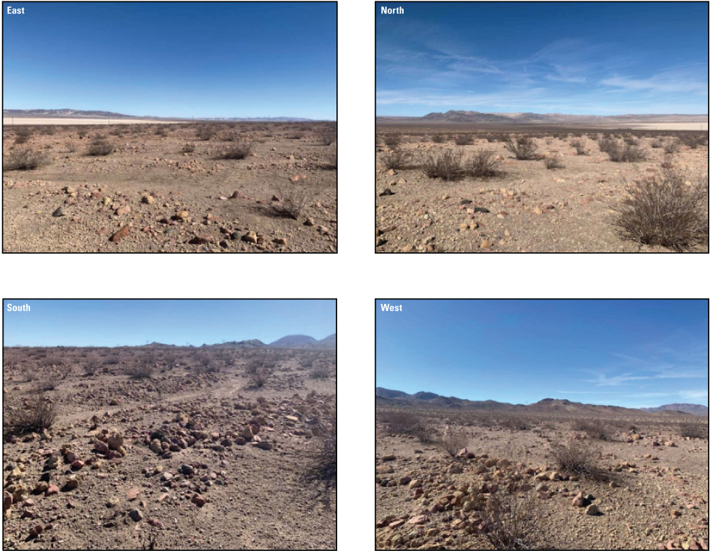
Site C1. Photographs taken on October 25, 2022, by Jeremy R. Fuller, U.S. Geological Survey.
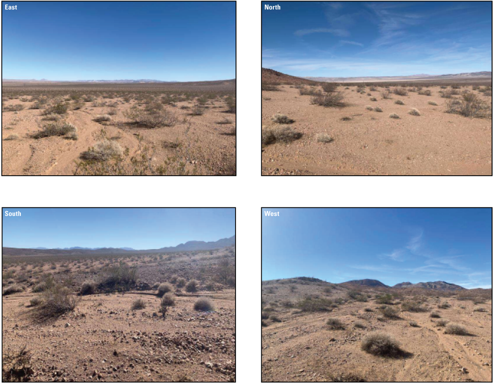
Site C2. Photographs taken on October 25, 2022, by Jeremy R. Fuller, U.S. Geological Survey.
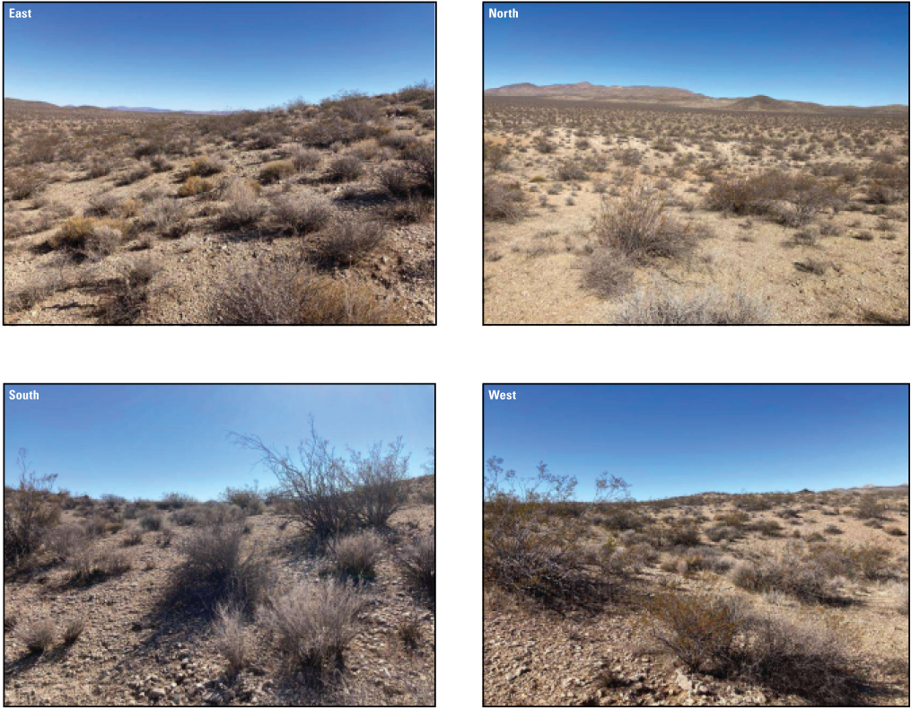
Site R1. Photographs taken on October 22, 2022, by Kathryn Davison, U.S. Geological Survey.
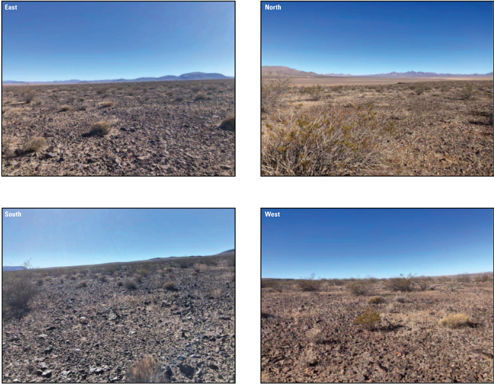
Site R2. Photographs taken on October 11, 2022, by Evan Cedrone, U.S. Geological Survey.
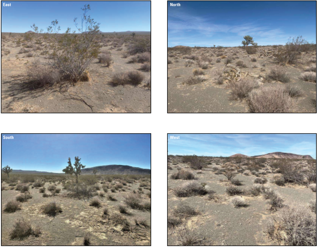
Site R3. Photographs taken on October 22, 2022, by Kathryn Davison, U.S. Geological Survey.
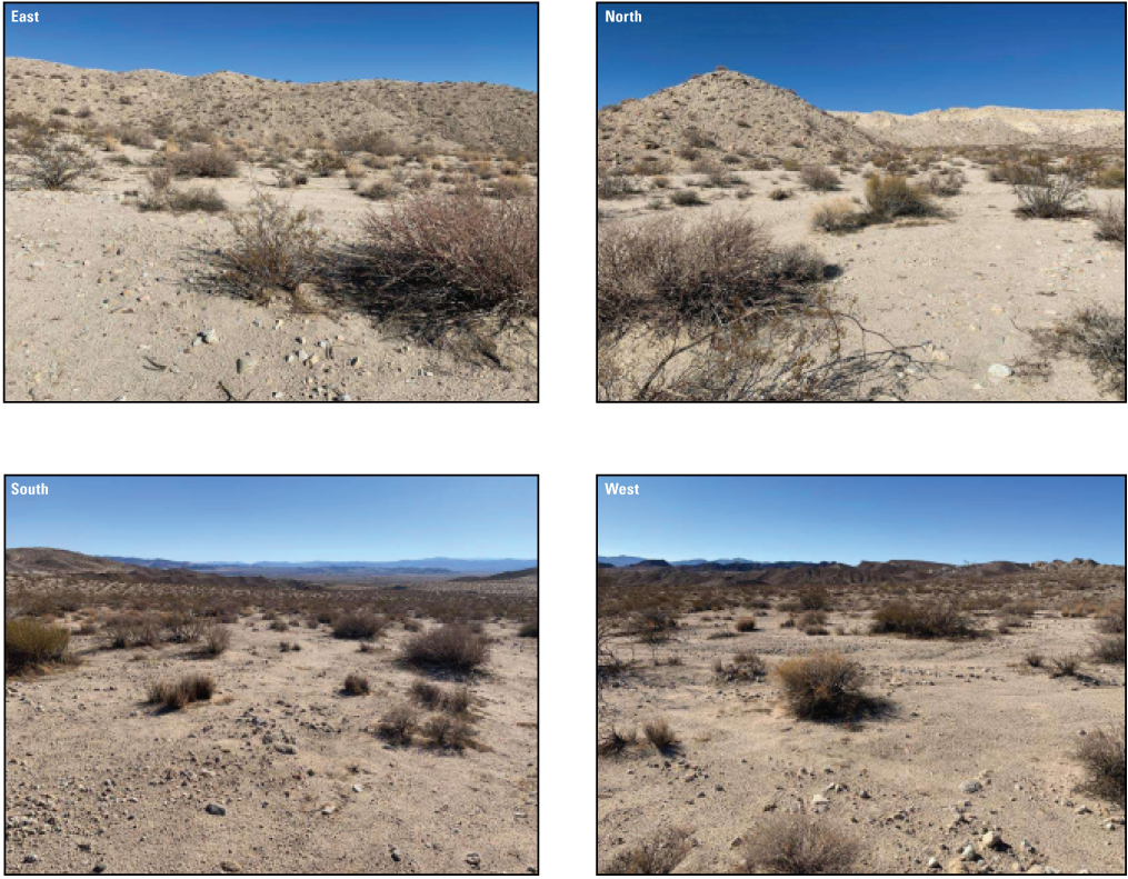
Site R4. Photographs taken on November 11, 2022, by Meghan Connelly, U.S. Geological Survey.
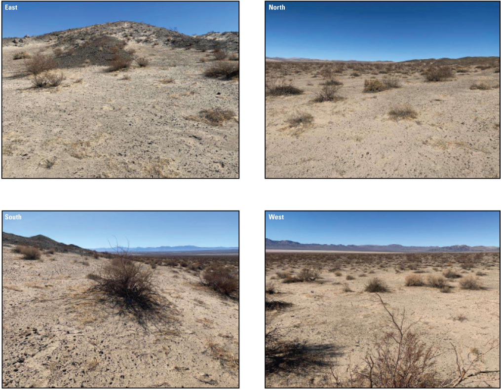
Site R5. Photographs taken on November 11, 2022, by Alison Haigh, U.S. Geological Survey.
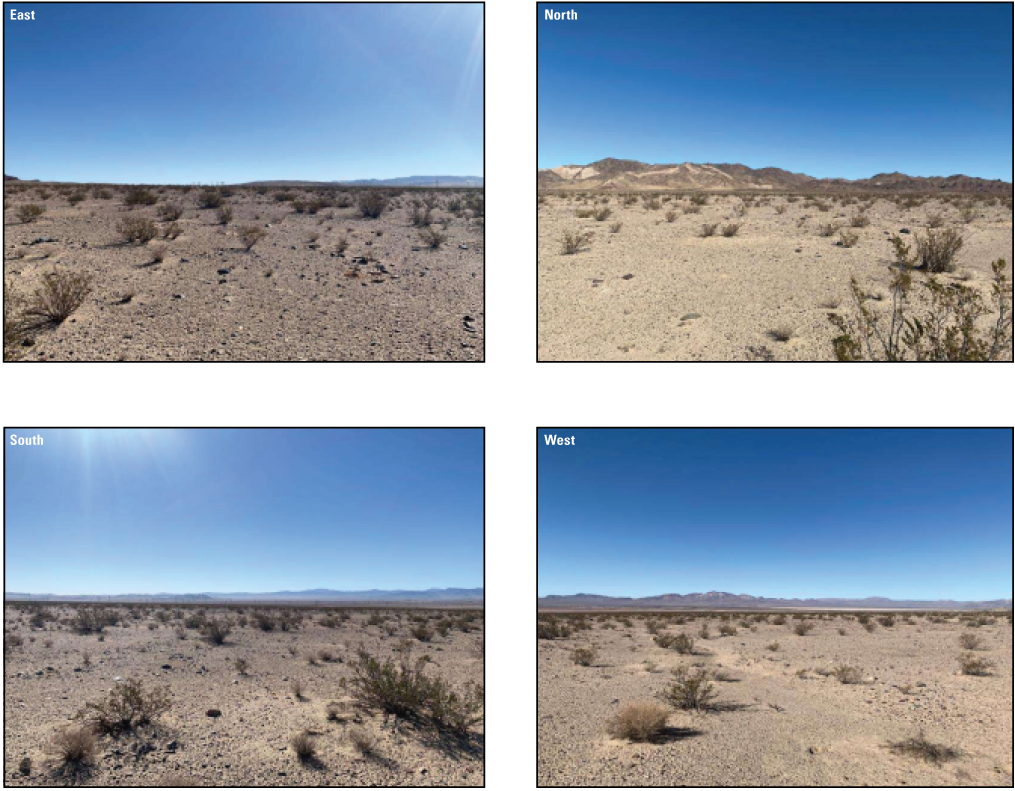
Site R6. Photographs taken on October 25, 2022, by Jeremy R. Fuller, U.S. Geological Survey.
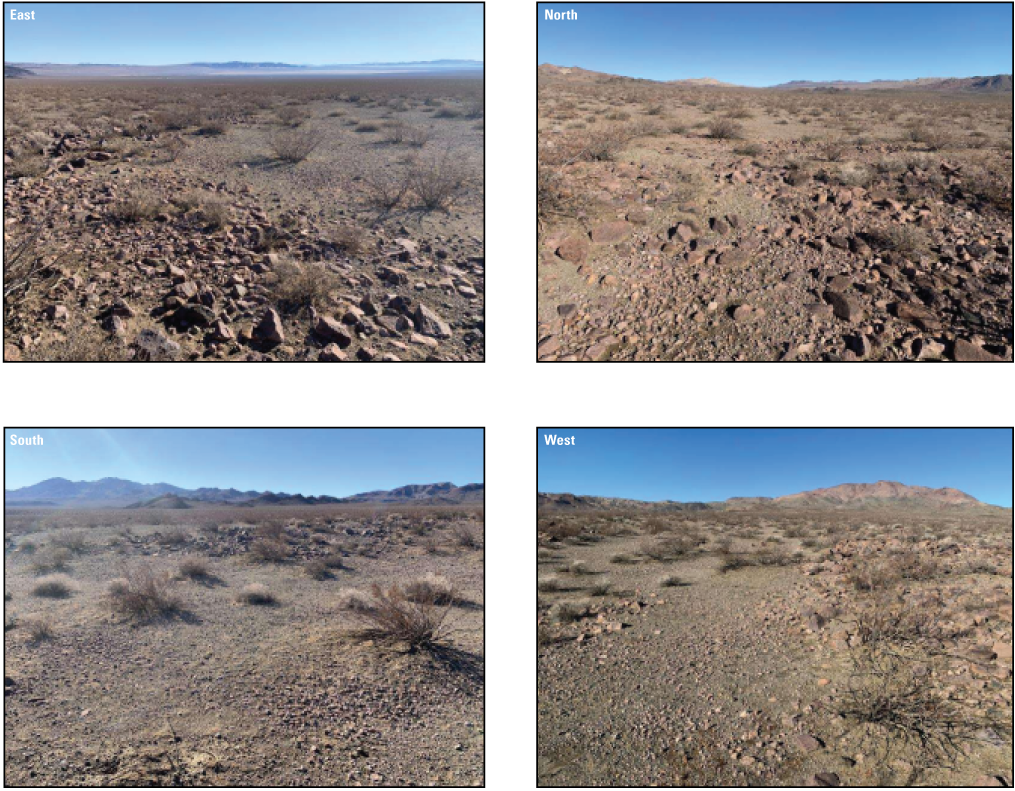
Site R7. Photographs taken on November 11, 2022, by Meghan Connelly, U.S. Geological Survey.
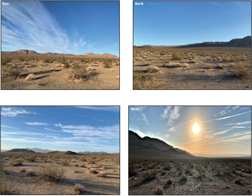
Site R8. Photographs taken on October 22, 2022, by Kathryn Davison, U.S. Geological Survey.
Conversion Factors
International System of Units to U.S. customary units
Temperature in degrees Celsius (°C) may be converted to degrees Fahrenheit (°F) as follows:
°F = (1.8 × °C) + 32.
Temperature in degrees Fahrenheit (°F) may be converted to degrees Celsius (°C) as follows:
°C = (°F − 32) / 1.8.
Abbreviations
AICc
Akaike’s information criterion corrected for small sample size
AKDE
autocorrelated kernel density estimation
Army
U.S. Department of the Army
BCS
body condition score
BLM
Bureau of Land Management
CDFW
California Department of Fish and Wildlife
DOD
Department of Defense
DOI
Department of Interior
ELISA
enzyme-linked immunosorbent assay
GPS
Global Positioning System
MCL
midline carapace length
NTC
National Training Center (Fort Irwin)
OHV
off-highway vehicle
qPCR
quantitative polymerase chain reaction
SCR
spatial capture-recapture
SEA
Southern Expansion Area
TeHV2
Testudinid herpesvirus 2
URTD
Upper Respiratory Tract Disease
USFWS
U.S. Fish and Wildlife Service
USGS
U.S. Geological Survey
UTM
Universal Transverse Mercator
WTA
Western Training Area
WTATS
Western Training Area Translocation Site
For more information concerning the research in this report, contact the
Director, Western Ecological Research Center
U.S. Geological Survey
3020 State University Drive East
Sacramento, California 95819
https://www.usgs.gov/centers/werc
Publishing support provided by the Science Publishing Network,
Sacramento Publishing Service Center
Disclaimers
Any use of trade, firm, or product names is for descriptive purposes only and does not imply endorsement by the U.S. Government.
Although this information product, for the most part, is in the public domain, it also may contain copyrighted materials as noted in the text. Permission to reproduce copyrighted items must be secured from the copyright owner.
Suggested Citation
Esque, T., Xiong, A., Doyle, S., Murphy, S., Wilhite, C., and Nussear, K., 2024, Desert Tortoise translocation plan for the U.S. Department of the Army National Training Center and Fort Irwin Western Training Area: U.S. Geological Survey Scientific Investigations Report 2024–5092, 94 p., https://doi.org/10.3133/sir20245092.
ISSN: 2328-0328 (online)
Study Area
| Publication type | Report |
|---|---|
| Publication Subtype | USGS Numbered Series |
| Title | Desert Tortoise translocation plan for the U.S. Department of the Army National Training Center and Fort Irwin Western Training Area |
| Series title | Scientific Investigations Report |
| Series number | 2024-5092 |
| DOI | 10.3133/sir20245092 |
| Publication Date | December 16, 2024 |
| Year Published | 2024 |
| Language | English |
| Publisher | U.S. Geological Survey |
| Publisher location | Reston, VA |
| Contributing office(s) | Western Ecological Research Center |
| Description | Report: x, 94 p.; Data Release |
| Country | United States |
| State | California |
| Other Geospatial | Fort Irwin Western Training Area |
| Online Only (Y/N) | Y |