

Spatiotemporal Variability of Algal Biomass and Nitrate in Owasco and Seneca Lakes in the Finger Lakes Region, New York, in 2019
Links
- Document: Report (9.22 MB pdf) , HTML , XML
- Appendixes:
- Appendix 1 (657 KB pdf) - Quality Assurance Project Plan for Discrete Water-Quality Samples, Measurements, and Shoreline Surveys Conducted for the Cyanobacterial Harmful Algal Blooms Advanced Monitoring Pilot Study
- Appendix 2 (397 KB pdf) - Standard Operating Procedure for the Analysis of Total Microcystins and Nodularins in Discrete Water-Quality Samples for the Cyanobacterial Harmful Algal Blooms Advanced Monitoring Pilot Study
- Data Releases:
- USGS data release - High-resolution spatial water-quality and discrete phytoplankton data, Owasco Lake, Seneca Lake, and Skaneateles Lake, Finger Lakes Region, New York, 2018–2019
- USGS data release - Field data for an evaluation of sensors for continuous monitoring of harmful algal blooms in the Finger Lakes, New York, 2018–2020
- Download citation as: RIS | Dublin Core
Acknowledgments
The authors thank Gregory Boyer and the laboratory staff at the State University of New York College of Environmental Science and Forestry for confirmatory analysis of cyanotoxins by liquid chromatography mass spectrometry and tandem mass spectrometry. The authors also thank Alan Wilson and his research team at Auburn University for project support.
Abstract
Cyanobacterial harmful algal blooms (CyanoHABs) have become increasingly common, threatening the security of water resources globally. The U.S. Geological Survey conducted high-resolution nearshore mapping surveys using boat-mounted multiparameter sondes and nitrate sensors during the summer and fall of 2019 on Owasco Lake and Seneca Lake, two lakes with documented CyanoHABs in the Finger Lakes region of New York State. Discrete sensor measurements and water-quality samples were collected at fixed points along survey routes and continuous data were generated at open-water monitoring platforms. This investigation examined whether water-quality information from nearshore surveys was representative of open-water conditions and if nearshore surveys could be used to identify areas with localized nearshore CyanoHABs and potential sources of nutrients not captured by tributary sampling.
In addition to comparisons across methods, nearshore concentrations of nitrate and chlorophyll were evaluated relative to tributary outlets, cyanobacterial abundance and biovolume at discrete locations, and the locations of near-surface CyanoHABs that were designated as “confirmed with high toxins” by the New York State Department of Environmental Conservation. Nitrate and chlorophyll concentrations were comparable across methods for each lake, although concentration ranges were typically higher for nearshore mapping datasets than for nearshore discrete datasets. Nearshore surveys indicated areas of nitrate enrichment that varied temporally in both lakes. Orthophosphate was not routinely detected. Across methods, median chlorophyll concentrations were higher for the summer survey than for the fall survey in Owasco Lake. Nearshore chlorophyll concentrations varied more temporally in Owasco Lake than in Seneca Lake.
Phytoplankton and cyanobacterial abundance and biovolume were about five times higher in Owasco Lake than in Seneca Lake. Cyanobacteria dominated the phytoplankton community in most samples, and Microcystis comprised the bulk of the cyanobacterial biovolume. The most abundant potential cyanotoxin-producing (specifically microcystins) genera were Microcystis, Synechococcus, Aphanocapsa, and Pseudanabaena. The cyanobacterial community composition was comparable between open-water monitoring platforms and nearshore samples. Microcystins were detected in seven survey samples from Owasco Lake, in one survey sample from Seneca Lake, and in one sample each from the open-water monitoring platforms on Owasco and Seneca Lakes that were collected about 7 days before the fall surveys. Microcystin detections were not consistently associated with high cyanobacterial cell counts or cyanotoxin-producing genera.
Results from nearshore surveys were comparable to open-water monitoring platforms and discrete nearshore observations in the absence of nearshore or open-water CyanoHABs in these systems during the study. Patterns of nearshore concentrations of nitrate and chlorophyll from nearshore surveys may aid in the identification of areas with localized nitrate loading and shifts in phytoplankton abundance and community composition.
Introduction
In recent decades, the excessive growth and accumulation of phytoplankton in aquatic ecosystems, commonly referred to as algal blooms, has been identified as an increasingly serious threat to water quality worldwide (Heisler and others, 2008; Paerl and Otten, 2013; Brooks and others, 2016). Algal blooms occur when growth of phytoplankton populations, promoted by favorable environmental conditions, dramatically increases, resulting in algal biomass production. The term “harmful algal blooms” (HABs) is frequently used synonymously to describe these events because of the potentially negative effects associated with the formation and proliferation of algal blooms. Dense cell concentrations associated with HABs may manifest as nuisance accumulations in near-surface waters, along shorelines, or in bays and coves, thereby negatively affecting aesthetics, recreational use, and local economic benefits derived from being on or near water (Hudnell, 2010; Sanseverino and others, 2016). Additionally, aquatic ecosystem function and health can be affected by HABs, including reduced water clarity, loss of dissolved oxygen during bloom senescence, and changes in aquatic food webs (Hudnell, 2008; Graham and others, 2016; Chorus and Welker, 2021). HABs associated with higher concentrations of cyanobacteria are of particular concern and are differentiated by the term “CyanoHABs” herein. Some taxa of cyanobacteria have known cyanotoxin-producing strains and exposure can cause acute and chronic illnesses in humans and animals, including skin and respiratory irritation, liver and kidney damage, and neurological problems (Chorus and Welker, 2021). Cyanobacteria are a diverse phylum consisting of numerous genera and species, and not all cyanobacteria produce cyanotoxins (New York State Department of Environmental Conservation [NYSDEC], 2019a, b, c;EcoLogic LLC and Anchor QEA LLC, 2022b). Exposure to CyanoHABs and associated cyanotoxins can result from ingestion of contaminated water or from dermal contact with algal accumulations, making it particularly concerning when CyanoHABs are found in water bodies used as drinking-water supplies and recreational resources (Boyer, 2007; Graham and others, 2008).
Globally, the frequency of reported CyanoHABs seems to be increasing (O’Neil and others, 2012; Favot and others, 2023; Gorney and others, 2023), and reports of human and animal illness and animal deaths from exposure to CyanoHABs are increasingly common (Yoo and others, 1995; Hudnell, 2008; Treviño-Garrison and others, 2015; Graham and others, 2016), thereby intensifying the need for early CyanoHAB detection and management strategies. Factors known to affect CyanoHAB formation include weather (warm, calm periods); nutrient concentrations (Downing and others, 2001); food-web changes due to invasive species, such as zebra mussels (Dreissena polymorpha) and quagga mussels (Dreissena bugensis) (Hecky and others, 2004; Raikow and others, 2004); and lake geometry or orientation (Paerl and Otten, 2013). Localized nutrient sources, nitrogen-to-phosphorus ratios, nutrient fractions (dissolved or particulate), nutrient speciation, and seasonal nutrient inputs may be a proximate cause of some blooms in some lakes (Downing and others, 2001; Anderson and others, 2002; Glibert and Burford, 2017). CyanoHABs tend to occur most often in eutrophic (high productivity) lakes but may also occur in oligotrophic (low productivity) systems. Nutrient enrichment and a warming climate are generally considered to be primary causes of increased occurrence of CyanoHABs in oligotrophic environments (Carey and others, 2008, 2012; Sterner and others, 2020; Reinl and others, 2021); however, the interactions among causal mechanisms, effectiveness of management strategies to combat CyanoHAB and cyanotoxin occurrence, and the ability of in-waterbody controls to limit effects on waterbody usage remain unclear.
The New York State Department of Environmental Conservation (NYSDEC) has documented CyanoHABs in more than 400 waterbodies throughout the State between 2012 and 2020, and an increased number of reported CyanoHABs during the same period (Gorney and others, 2023). The Finger Lakes are in central New York State and are important recreational, drinking-water, and economic resources (NYSDEC, 2019a; Halfman and others, 2023; Prestigiacomo and others, 2023). The Finger Lakes region, named for 11 large north-south-oriented lakes known as the Finger Lakes (fig. 1), has also experienced an increasing number of reported CyanoHABs in recent decades (NYSDEC, 2019a). In 2017, NYSDEC reported that all 11 Finger Lakes experienced open-water or shoreline CyanoHABs, or both, even those lakes that have been historically characterized by low concentrations of nutrients and chlorophyll-a, which is an indicator of algal biomass (NYSDEC, 2018a). Blooms in the Finger Lakes are often reported as accumulations in nearshore areas, although open-water blooms also occur. The NYSDEC differentiates harmful CyanoHABs as those with cyanotoxin concentrations exceeding the NYSDEC “confirmed with high toxins” bloom thresholds of 10 micrograms per liter (µg/L) of microcystin for open water samples and 20 µg/L of microcystin for shoreline samples (Gorney and others, 2023).
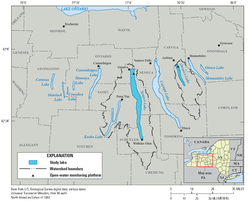
Map of the Finger Lakes region of New York showing watersheds and locations of open-water monitoring platforms on Owasco Lake (U.S. Geological Survey [USGS] site number 425327076313601) and Seneca Lake (USGS site number 425027076564401) (U.S. Geological Survey, 2020).
Variability of cyanobacteria concentrations in surface-water systems poses challenges when trying to capture the dynamic nature of cell concentrations and cyanotoxins associated with CyanoHABs through monitoring efforts, particularly in the collection of periodic, discrete water samples (Ho and Michalak, 2015; Kraus and others, 2017; Prestigiacomo and others, 2023). These challenges are exacerbated by the diffuse, low-concentration nature of background cyanobacterial communities that are present throughout the pelagic zones of low-productivity lakes (Reinl and others 2021), including some of the Finger Lakes (Prestigiacomo and others, 2023). Additionally, identification of sources of dissolved nutrient loads that are known to contribute to the growth and proliferation of CyanoHABs (Paerl and Otten, 2013), such as nitrate and orthophosphate, can be challenging and expensive using discrete sampling methods, especially in low-nutrient systems such as those found in some of the Finger Lakes. High-resolution mapping surveys, which are surveys containing spatially and temporally dense measurements, have proven to be successful in documenting the distribution of cyanobacteria, chlorophyll, and concentrations of nutrients (Crawford and others, 2015; Foster and others, 2017, 2019; Stumpner and others, 2020).
The NYSDEC initiated the CyanoHABs advanced monitoring pilot study in collaboration with the U.S. Geological Survey (USGS) and the New York State Department of Health to develop and implement comprehensive monitoring strategies for CyanoHABs in several Finger Lakes. The advanced monitoring pilot consisted of a series of studies conducted between 2018 and 2020 to assess traditional and innovative monitoring approaches and technologies with the goal of informing future monitoring strategies and improving the understanding of CyanoHABs in New York State.
One objective of the advanced monitoring pilot was to conduct high-resolution, within-lake, nearshore mapping surveys (herein called nearshore surveys) with continuous water-quality instrumentation. Two nearshore surveys were conducted using boat-mounted multiparameter sondes and nitrate analyzers on both Owasco Lake and Seneca Lake in 2019. The goals of this study were (1) to investigate whether water-quality information from nearshore surveys could be used to identify potential sources of nutrients beyond those captured by tributary sampling, (2) to identify areas with localized nearshore CyanoHABs, and (3) to provide baseline data that were representative of open-water conditions. High-resolution datasets, such as those collected for this study, are key to understanding complex spatiotemporal dynamics that may not be captured by monitoring strategies focusing on periodic, discrete-sample collection. Nearshore water-quality surveys may be used as tools in robust monitoring strategies and may lead to the development of more effective early indicators of CyanoHABs (Downing and others, 2017; Foster and others, 2022).
Purpose and Scope
This report presents the results of a USGS investigation that documented the nearshore spatial and temporal distribution of epilimnetic nitrate concentrations and estimated concentrations of the algal pigment chlorophyll, which is a proxy for total algal biomass, from fluorescence measurements using high-resolution sensor data collected in Owasco and Seneca Lakes in 2019. Spatially continuous concentrations of nitrate and chlorophyll fluorescence recorded by the nearshore surveys were compared to temporally continuous measurements collected from fixed-location, open-water monitoring sensor platforms (herein called monitoring platforms) and near-surface discrete sensor measurements and water samples collected at twelve targeted nearshore locations on each lake (fig. 2). Results of a paired investigation in these two lakes that evaluated related sensor- and laboratory-measured values from the monitoring platforms as representative measurements of nutrients and algal pigments (as indicators of phytoplankton biomass) are available in Johnston and others (2024). Despite Owasco Lake and Seneca Lake being phosphorus-limited (Halfman and others, 2023), analysis of nutrients for this study was limited to nitrate because orthophosphate was rarely detected above the reporting limit in either water samples or in data collected from the monitoring platform on either lake (Johnston and others, 2024).
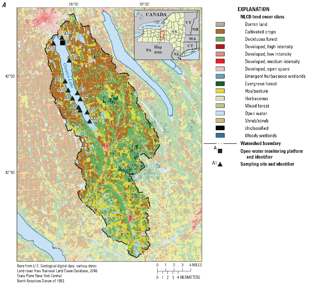
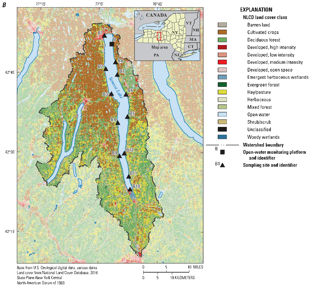
Maps of the watersheds of A, Owasco Lake, and B, Seneca Lake, New York, showing land cover and locations of discrete sampling sites and open-water monitoring platforms. Land cover data are from the National Land Cover Database (NLCD; Dewitz, 2023); see table 1 for list of identifiers and corresponding site names and numbers (U.S. Geological Survey, 2020).
The survey methods used in this study may be used to identify nutrient sources beyond those captured by in-channel tributary monitoring and in areas with an increased risk of CyanoHAB production and proliferation. Paired with results from other studies conducted as part of the advanced monitoring pilot, knowledge gained from this study may be used to help identify the most informative and cost-effective monitoring strategies for documenting and understanding the environmental factors associated with CyanoHAB occurrence in these systems. Results from these studies may further inform the development and implementation of future CyanoHAB monitoring strategies in the Finger Lakes region, across New York State, and throughout the Nation.
Description of the Study Area
The Finger Lakes region of New York State is situated in the central part of the State, within the eastern Great Lakes and Hudson Lowlands ecoregion (Omernik and Griffith, 2014) and northeast climate region (Karl and Koss, 1984). The Finger Lakes region consists of 11 glacially formed lakes within the Lake Ontario watershed and is named based on the narrow, elongated shapes of the lakes, generally oriented north-south (fig. 1). The region is located south of Lake Ontario and bordered by the cities of Syracuse to the north and east, Rochester to the west, and Ithaca to the south. Approximately 35 percent of the area of New York State, or approximately 23,310 square kilometers (km2), is within the Finger Lakes watershed, and all or part of 14 counties.
Despite a shared formation history and similar morphology, each of the Finger Lakes is associated with a unique combination of physical, chemical, and biological traits, and water-use functionality. The increased occurrences of CyanoHABs in the region, paired with the unique combinations of traits specific to each lake, offer an ideal setting to test innovative, advanced monitoring methodologies across multiple systems located within a relatively small area. Detailed descriptions of the Finger Lakes region and each of the individual lakes can be found in Callinan (2001). For this report, analysis and discussion focus on 2 of the 11 Finger Lakes: Owasco Lake and Seneca Lake.
Owasco Lake
Owasco Lake is the sixth-largest Finger Lake, with a surface area of 26.7 km2, a volume of 781 million cubic meters (Mm3), and shoreline length of about 37 kilometers (km; NYSDEC, 2019a). The area of the Owasco Lake watershed is approximately 525 km2, and watershed land use is primarily agricultural (fig. 2A). Owasco Lake serves as a drinking-water source for the City of Auburn and the Town of Owasco in addition to supporting a variety of recreational uses. Data collected between 2017 and 2018 indicate that Owasco Lake is mesotrophic (moderately productive; NYSDEC, 2019a) based on statewide averages from New York of key water-quality indicators, and from assessment criteria for lake trophic status determined from historical statewide monitoring programs (NYSDEC, 2018b; EcoLogic LLC and Anchor QEA LLC, 2022b). As of 2018, Owasco Lake was identified as oligotrophic for total phosphorus (0.008 milligrams per liter [mg/L]), and mesotrophic for chlorophyll-a (3.4 μg/L) and water clarity (Secchi disk depth of 3.7 meters [m]) (NYSDEC, 2019a). Owasco Lake has a summer average of total nitrogen concentrations of 0.95 mg/L as nitrogen (mg/L as N), and nitrate (nitrate plus nitrite, herein referred to as nitrate) concentrations of 0.58 mg/L as N (NYSDEC, 2019a). The NYSDEC has reported at least one CyanoHAB categorized as a “confirmed with high toxins” bloom (microcystin concentrations above 10 µg/L for open water or 20 µg/L for shoreline samples) on Owasco Lake every year between 2013 to 2019 (NYSDEC, 2023), more commonly occurring in the late summer and early fall (NYSDEC, 2018b). In 2016, detections of microcystins at low concentrations in finished drinking water spurred concerns about CyanoHABs and led to the installation of a granulated activated-carbon filtration system in the drinking-water treatment facilities of the Town of Owasco (NYSDEC, 2018a; EcoLogic LLC and Anchor QEA LLC, 2022b).
Seneca Lake
Seneca Lake is the largest of the Finger Lakes, and has a surface area of 175.4 km2, a volume of 15,500 Mm3, and a shoreline length of about 121 km (NYSDEC, 2019a). The watershed area of Seneca Lake is approximately 1,831 km2 and consists primarily of agricultural land, with a higher percentage of forested lands in the southern section of the watershed (fig. 2B). Seneca Lake serves as a drinking-water source for the City of Geneva and supports a variety of recreational uses (EcoLogic LLC and Anchor QEA LLC, 2022a). Using assessment criteria for lake trophic status as determined from historical statewide monitoring programs in New York (NYSDEC, 2018b; EcoLogic LLC and Anchor QEA LLC, 2022a) and statewide averages of key water-quality indicators, data collected between 2017 and 2018 indicated that Seneca Lake is shifting from meso-oligotrophic (low to moderately productive; Callinan, 2001) to mesotrophic (moderately productive; NYSDEC, 2019a). As of 2018, Seneca Lake was identified as mesotrophic for total phosphorus (0.011 mg/L), chlorophyll-a (5.4 µg/L), and water clarity (Secchi disk depth of 3.7 m; NYSDEC, 2019a). Seneca Lake has summer average nitrogen concentrations that are about half of those observed at Owasco Lake (total nitrogen: 0.55 mg/L as N, nitrate: 0.24 mg/L as N; NYSDEC, 2019a). The NYSDEC has reported at least one CyanoHAB categorized as a “confirmed with high toxins” bloom on Seneca Lake every year from 2015 to 2019 (NYSDEC, 2023).
Methods
All water-quality instrumentation was operated and maintained in accordance with USGS guidelines and procedures (Wagner and others, 2006; Pellerin and others, 2013; Foster and others, 2022; Booth and others, 2023). Discrete water samples were collected following USGS best practices (U.S. Geological Survey, variously dated). Specific sampling methodologies are detailed below and in Johnston and others (2024). All aspects of this study operated under a quality-assurance project plan (app. 1). All discrete sensor measurements and water-quality sample data, excluding phytoplankton data, are available through the Water Quality Portal database (WQP; Water Quality Portal, 2021). Phytoplankton and nearshore sensor survey data are available in a USGS data release (Stouder and others, 2023).
Nearshore Sensor Survey Data
Owasco Lake and Seneca Lake were each surveyed twice in 2019. Nearshore data were collected on June 26, 2019, and October 8, 2019, on Owasco Lake, and from July 9 to 10, 2019, and October 9 to 10, 2019, on Seneca Lake. A YSI EXO2 multiparameter sonde and Hach NITRATAX plus sc nitrate sensor were fixed to an L-shaped mount that was attached to the side of a motorboat, which allowed the instrumentation to be submerged approximately 0.5 m below the water surface but above the keel of the boat while traveling. This depth was chosen based on similar studies (Foster and others, 2017; 2019) and the shallow nature of the nearshore areas that were surveyed. The sonde was mounted parallel to water surface with sensors facing the rear of the boat to reduce air entrainment caused by turbulence at the sensor faces and to increase stability in readings. The nitrate sensor was mounted perpendicular to the water surface to allow flow through the instrument measurement pathway. Where possible, the boat traveled within 100 m of shore around the entire circumference of each lake during each survey. Weather conditions—particularly fog—and shallow depths affected the ability of the survey boat to maintain a 100-m distance from shore. The boat maintained a speed of about 8 km per hour to maximize transit rate while minimizing the effects of turbulence on the sensor readings.
The YSI EXO2 multiparameter sonde was chosen because of its wide use throughout the USGS to collect data for studies focused on phytoplankton biomass and community composition (Foster and others, 2022). The sonde was equipped with sensors to measure water temperature, specific conductance, turbidity, pH, dissolved oxygen, fluorescent dissolved organic matter, chlorophyll (fluorescence), and phycocyanin (fluorescence). All parameters were recorded at 30-second intervals. A centralized antifouling wiper was programmed to clean each sensor every 5 minutes during the survey. Specifications for the sonde and individual sensors are detailed in YSI Inc. (2021).
The Hach NITRATAX plus sc is an ultraviolet nitrate sensor with a 2-millimeter (mm) measuring pathway, and was chosen for its ease of use, durability, and measuring range. The measured value is reported in units of mg/L as N. The sensor contains a two-beam absorption photometer with integrated compensation for turbidity. Continuous sensor measurements were recorded at 30-second intervals. The measuring window was mechanically cleaned with an antifouling wiper every 5 minutes throughout the survey. Specifications for the sensor are detailed in Hach Co. (2023).
Global positioning system (GPS) location data were collected using a Garmin GPSMAP 64s handheld unit. The internal clocks of the water-quality sensors and the GPS unit were synchronized to local time before each nearshore survey. Location information was collected at irregular time intervals, but generally, location readings were taken at least every 30 seconds to 1 minute. The time interval for location information is comparable to the time interval for collection of water-quality sensors, although the timestamps of water-quality data and GPS location data did not correspond precisely. Timestamps for all GPS and nearshore sensor survey measurements were rounded to the nearest recording interval, which was typically 30 seconds or 1 minute, depending on the sensor used. Water-quality sensor data and GPS coordinates were then aligned to provide approximately 1-minute data intervals with corresponding location information. Where GPS location data were not collected within 15 seconds of water-quality sensor measurements, both location data and water-quality measurements were excluded from the final dataset.
The nearshore survey data do not correspond precisely in time or space with the collection of discrete sensor measurements and water-quality samples. Two boats and field teams were used for each survey event. One team collected continuous, nearshore sensor-survey data and the other team collected nearshore discrete sensor measurements and water samples. The boats traveled in opposite directions around each lake during the first survey event. The boats traveled in the same direction in October 2019, which decreased the time offset between sensor survey data and discrete water-quality measurements and sample collection. In Seneca Lake, the survey and sampling efforts were completed over 2 consecutive days, with both boats operating on the northern half of the lake on the first day and the southern half on the following day. Nearshore sensor survey data are available in Stouder and others (2023).
Discrete Sample Data
Discrete water samples were collected from Owasco Lake and Seneca Lake twice in 2019 concurrent with the nearshore surveys. Twelve targeted locations were identified and sampled on each of the study lakes (table 1) based on a combination of records of previous CyanoHABs reported by NYSDEC and USGS field staff observations during the nearshore surveys, such as visual observations of algal indicators or the proximity of locations to the mouths of major tributaries. Fifty-two nearshore discrete water-quality samples were collected during the study, including four sequential replicates, with one replicate collected on each lake (Owasco and Seneca) during each survey (summer and fall). All replicates were analyzed for nutrients and chlorophyll-a; phytoplankton abundance and biovolume and cyanotoxins were limited to the two fall surveys.
Table 1.
Discrete water-quality sample sites and open-water monitoring platform sites in Owasco Lake and Seneca Lake, New York, and sampling dates.[Map identifier is used in figures 2-8; data from Water Quality Portal (Water Quality Portal, 2021 [https://www.waterqualitydata.us]) and the U.S. Geological Survey National Water Information System (U.S. Geological Survey, 2020); USGS, U.S. Geological Survey; NY, New York]
At each discrete sampling location, Secchi and total water-column depths were measured. The multiparameter sonde and nitrate meter were submerged approximately 0.5 m below the water surface and allowed to stabilize based on methods described in Gibs and others (2012) before recording sensor measurements to be associated with the discrete sample(s).
Before collecting raw water directly into sample bottles, the tubing intake was submerged approximately 0.5 m below the water surface, and, using a peristaltic pump and plastic tubing, the line was purged for at least two minutes. Prior to collection of filtered aliquots, a Pall 0.45-micrometer (µm) filter was purged with approximately 8 liters (L) of deionized water before being purged with raw sample water for at least two minutes. Samples were processed and preserved in the field based on constituent-specific methodology and immediately stored on ice (app. 1).
Water samples were analyzed for nitrate, orthophosphate, extracted chlorophyll-a, and additional constituents and parameters that are outside the scope of this report (a complete list of constituents sampled and detection limits are in app. 1). All nitrate, orthophosphate, and extracted chlorophyll-a samples were analyzed by the U.S. Geological Survey National Water Quality Laboratory. Nitrate was determined analytically as nitrate plus nitrite (although nitrite only composed a small part of this total in this study) and is reported in mg/L as N. Nitrate samples were filtered and analyzed colorimetrically by enzymatic reduction using an automated discrete analyzer as described in Patton and Kryskalla (2011). Orthophosphate samples were analyzed by discrete analyzer phosphomolybdate formation and colorimetry as described in Fishman (1993). For chlorophyll-a samples, water was pumped directly into 1-L amber-colored high-density polyethylene (HDPE) bottles, then immediately homogenized and filtered. Chlorophyll-a samples were collected onto 47-mm-diameter glass fiber filters with a 0.3-µm pore size. Chlorophyll-a was analyzed fluorometrically using a modification of U.S. Environmental Protection Agency (EPA) Method 445.0 as described in Arar and Collins (1997). Discrete water-quality results are available through the WQP (Water Quality Portal, 2021).
In October 2019, water samples were collected for phytoplankton identification and enumeration and cyanotoxin analysis at each discrete sample location. Phytoplankton samples were collected in 250 milliliter (mL) HDPE bottles and preserved with glutaraldehyde to a concentration of 0.25 percent by volume and analyzed by PhycoTech, Inc. (St. Joseph, Michigan). Glutaraldehyde was used to preserve the fluorescence properties of the algae. Identification and enumeration of phytoplankton using microscopy was conducted using hydroxypropyl methacrylate-mounted slides with fluorescence-enabled microscopy, a count threshold of 400 natural units, and a size range of detection from 0.9 µm–25 mm. Phytoplankton were enumerated to the lowest possible taxonomic level, which was at least to genus-level for most organisms. To correctly enumerate and identify taxa that may vary by several orders of magnitude in size, counts were made at multiple magnifications ranging from 200× to 1,000× (PhycoTech, 2018). Random microscope fields were counted to a minimum of 400 natural units (colonies, filaments, or single cells) of all observed organisms (PhycoTech, 2018). Individuals from each species were then enumerated, and the average cell dimensions were recorded for biovolume calculations. Phytoplankton data, sample processing, analysis methods, and quality-assurance protocols are detailed in PhycoTech (2018). Phytoplankton data are available in Stouder and others (2023).
The cyanotoxin microcystin was analyzed by the USGS New York Water Science Center, an Environmental Laboratory Approval Program-certified laboratory for the analysis of total microcystins and nodularins using an indirect competitive enzyme-linked immunosorbent assay (ELISA) procedure based on EPA Method 546 (U.S. Environmental Protection Agency, 2016; app. 2). Ambient water samples were processed through three freeze/thaw cycles to lyse cyanobacterial cells and ensure all cyanotoxins were present in the dissolved phase. Lysates were filtered and analyzed using ELISA based on the congener-independent detection of the (all-S, all-E)-3-amino-9-methoxy-2,6,8-trimethyl-10-phenyldeca-4,6-dienoic acid (ADDA) amino acid side chain present in most microcystin and nodularin congeners. The endpoint of the ELISA procedure is the colorimetric determination of total microcystin and nodularin concentration, which is inversely proportional to sample absorbance. A four-parameter logistic regression model was used for calibration. Samples were sent to the State University of New York College of Environmental Science and Forestry (SUNY–ESF) for confirmatory analysis of microcystins by liquid chromatography with mass spectrometry (LCMS). Raw water aliquots of 100 to 150 mL were lyophilized and extracted in 10 mL of 50 percent methanol containing 1 percent acetic acid using ultrasound sonication. The extracts were centrifuged, and supernatants were filtered before analysis using methods comparable to those described in Martin and others (2020) and Barnard and others (2021). Samples were analyzed for microcystins (MC) by LCMS using a Waters Micromass ZQ 4000 mass detector for 21 MC congeners and nodularins as described in Boyer (2020). Concentrations were reported as microcystin-LR (MC-LR) equivalents and total microcystin concentrations were reported as the sum of all MC congeners and nodularins (Martin and others, 2020).
Water samples were also analyzed for total anatoxins, total cylindrospermopsins, and total saxitoxins by ELISA (USGS) and by confirmatory analysis by liquid chromatography with tandem mass spectrometry (LCMS/MS; SUNY–ESF) for total anatoxins and cylindrospermopsins. No anatoxins, cylindrospermopsins, or saxitoxins were detected above reporting limits in any water samples collected as part of this investigation by ELISA or LCMS/MS and, therefore, are not described in this report because these data did not add substantially to interpretation and analysis. Cyanotoxin concentrations from discrete water-quality samples are available through WQP (Water Quality Portal, 2021).
Open-Water Monitoring Platform Data
Continuous water-quality sensor data were collected at fixed, floating, open-water monitoring platforms deployed on both of the study lakes from mid-May to mid-November of 2019 (fig. 1): Owasco Lake Platform (USGS site identification number 425327076313601) and Seneca Lake Platform (USGS site identification number 425027076564401; U.S. Geological Survey, 2020). Each monitoring platform housed three YSI EXO2 multiparameter sondes equipped with the same sensors as those used in the nearshore sensor surveys, and an s::can nitro::lyser II optical nitrate sensor (s::can Messtechnik GmbH, 2011). Sensors were wiped by an antifouling wiper prior to each measurement. One of the three sondes and the optical nitrate sensor were deployed in near-surface water at about 1-meter depth. The other two sondes were deployed near the middle and bottom of the water column; details are available in Johnston and others (2024). Sensor readings were recorded at 15-minute intervals for sondes and at 5-minute intervals for the optical nitrate sensors. Although the same sensor was not used in the collection of the nearshore and the discrete sensor measurements of nitrate concentrations, both sensors operate on the same measurement principle that uses the absorbance of ultraviolet light by nitrate as measured by a photometer, and report results in the same units (Pellerin and others, 2013).
Discrete water-quality samples were collected biweekly at the monitoring platforms at near-surface depth (1 m) and analyzed for the same parameters as discrete nearshore water samples. A detailed description of the monitoring platform design and the results of a USGS investigation evaluating the deployed continuous sensor technologies is available in Johnston and others (2024). Continuous and discrete water-quality sensor and sample data from the monitoring platforms are available through the U.S. Geological Survey National Water Information System (NWIS; U.S. Geological Survey, 2020) and WQP (Water Quality Portal, 2021), respectively. Continuous nitrate sensor data were not measured at the monitoring platform in Owasco Lake on the dates of the nearshore survey in June 2019. Continuous nitrate sensor data were not measured at the monitoring platforms on the dates in October 2019 corresponding to nearshore surveys and discrete water sample collection in either lake.
Ancillary Data
The monitoring platforms were equipped with Vaisala WTX536 multiparameter weather sensors (Vaisala, 2022) that reported air pressure in units of millibars (mbar), air temperature on degrees C, relative humidity in percent, precipitation in units of inches (in.), wind speed in units of meters per second (m/s), and wind direction in degrees (°). Details specific to weather sensor installation are available in Johnston and others (2024), and meteorological data collected at the monitoring platforms are available in Johnston and others (2023). The multiparameter weather sensors were chosen to provide information about meteorological conditions to potentially relate meteorological conditions to changes in water quality or other environmental data. Daily mean discharge data were recorded at two USGS streamgages: Owasco Inlet below Aurora Street at Moravia, New York, a primary inflow to the southern end of Owasco Lake (USGS site 04235299); and Catharine Creek at Montour Falls, New York, a primary inflow to the southern end of Seneca Lake (USGS site 04232200). The two streamgages were referenced to describe generalized tributary inputs in the days preceding the nearshore surveys. Discharge data are available from the NWIS database (U.S. Geological Survey, 2020).
Data Synthesis and Analysis
Timestamps for all GPS and nearshore sensor survey measurements were rounded to the nearest recording interval, typically 30 seconds or 1 minute, dependent on the sensor used. Water-quality sensor data and GPS coordinates were aligned to provide approximately 1-minute data intervals. Where GPS location data were not collected within 15 seconds of water-quality sensor measurements, both location data and water-quality measurements were excluded from the final dataset. Data were reviewed for accuracy, and any outliers or “spikes” (instantaneous values that depart substantially from adjacent data points) were removed judiciously from the final dataset based upon visual examination of the data. Outliers most commonly occurred because of air entrainment due to turbulence at the sensor faces or when collocated data indicated otherwise stable physiochemical conditions. Nearshore sensor data were not averaged or smoothed across multiple readings. Continuous data generated from monitoring platforms were subset to (1) encompass only those measurements collected at the near-surface depth on the dates coinciding with nearshore surveys, and (2) include only those results corresponding to the period between the initial and final measurement of a given nearshore survey. Data were compiled using R Statistical Software (R Core Team, 2022).
The operating range of the Hach NITRATAX plus sc is 0.1 to 50 mg/L as N (measuring nitrate and nitrite) with an accuracy of 3 percent plus or minus 0.5 mg/L as N (Hach Co., 2023) and a resolution of 0.1 mg/L as N. Laboratory reporting limits for nitrate were less than 0.04 mg/L as N. No laboratory results from samples were reported as being below the laboratory reporting limit. The operating range of the YSI Total Algae-Phycocyanin sensor is 0 to 400 µg/L for chlorophyll (YSI Inc., 2021). Because sensor-measured concentrations of chlorophyll are derived from a scale of relative fluorescence units and thus are effectively qualitative by nature (Foster and others, 2022), field readings of values less than 0 are possible. In both Owasco and Seneca Lakes, concentrations of chlorophyll below 0 µg/L were recorded in the nearshore surveys, nearshore discrete measurements, and the monitoring platforms (Stouder and others, 2023; Johnston and others, 2023, 2024). Negative sensor measurements were censored at 0 because they fall outside of the operational range of the sensor and cannot be quantified. Laboratory analyses of chlorophyll-a had reporting limits of 0.1 µg/L. All laboratory-analyzed chlorophyll-a concentrations were reported above laboratory detection limits (number of samples [n]=48), and no censoring was applied.
Descriptive statistics were calculated for each nearshore survey, parameter, and data-collection method. Direct comparisons between laboratory-measured concentrations and sensor-measured concentrations with the monitoring platforms are not included in this report. A previous study utilizing data collected at the monitoring platforms demonstrated agreement between discrete sensor measurements and laboratory-measured concentrations of nitrate and chlorophyll over an extended time interval during which this investigation occurred (Johnston and others, 2024). Concentrations of nitrate and chlorophyll in Seneca and Owasco Lakes that were derived from laboratory- and sensor-measured concentrations were compared using correlation analysis (Helsel and others, 2020). Results of these comparisons indicated monotonic relations between laboratory- and sensor-measured concentrations of nitrate and chlorophyll in Seneca and Owasco Lakes.
Subsets of continuous data from the monitoring platforms were created to include data collected during the 24-hour period corresponding to the date of nearshore surveys, and data corresponding to the clock time during which nearshore surveys were conducted. Maps were created from the nearshore survey data for each lake, date, and constituent. The maps highlight concentrations above the 75th percentile from nearshore survey data to allow for the visual identification of potential localized nutrient inputs to the lakes and areas with localized CyanoHABs. Phytoplankton community composition and cyanotoxin concentration at the discrete sampling locations were described relative to the concentrations of nitrate or chlorophyll, or both, in nearshore surveys.
Quality Assurance and Quality Control
Quality assurance and quality control samples were collected as sequential replicates to evaluate variability resulting from water sample collection and processing techniques or temporal changes resulting from shifting environmental conditions (app. 1; Mueller and others, 2015). During the study, 48 environmental water samples and a single replicate from each lake for each survey (totaling 4 sequential replicates, or about 10 percent of all water samples) were collected and analyzed. Relative percent differences (RPDs) were used to quantify differences in analytical nitrate and chlorophyll-a concentrations but could not be calculated if one or both samples from the replicate pair were not analyzed or were associated with a censored value (a value less than the laboratory reporting limit; Zar, 1999). The RPD was calculated using the following equation:
where A and B are concentrations in each replicate pair.RPD values associated with laboratory-analyzed nitrate samples ranged from 0.53 to 4.30 percent with a median RPD of 1.80 percent (n=4 replicate pairs). Variability in concentrations from chlorophyll-a result pairs was higher; RPD values ranged between 8.00 and 65.2 percent, with a median RPD of 36.5 percent (n=4 replicate pairs). The two replicate pairs with the highest RPDs (57.6 and 65.2) had low chlorophyll-a concentration differences between replicate pairs (1.75 and 2.84 µg/L, respectively). No cyanotoxin detections above reporting limits were reported from replicate discrete sample pairs.
Absolute value logarithmic difference (AVLD) was used to estimate differences in phytoplankton and cyanobacterial biovolume in cubic micrometers per milliliter and in cell concentration in cells per milliliter between replicate pairs. AVLD was used because RPD is sensitive to rare taxa found in one of the samples and not the other. AVLD is calculated using the following equation:
where A and B are biovolume in cubic micrometers per milliliter or algal cell concentration in cells per milliliter in each replicate pair (Francy and others, 2015). Replicate pairs with AVLDs of less than one differed by less than an order of magnitude, and those with AVLDs of more than one differed by an order of magnitude or more.The AVLDs for phytoplankton biovolume (n=2 replicate pairs) ranged from 1.13 to 1.42 (median AVLD: 1.27) for total phytoplankton biovolume, and 1.59 to 1.83 (median AVLD: 1.71) for cyanobacterial biovolume. AVLDs for cell concentration (n=2 replicate pairs) ranged from 0.29 to 1.12 (median AVLD: 0.70) for total cell concentration, and 0.31 to 1.16 (median AVLD: 0.73) for cyanobacterial cell concentration. Cyanophyta made up 12 to 60 percent of phytoplankton biovolume and 87 to 97 percent of phytoplankton cell concentration across each of the included samples (n=4).
Higher variability between replicate pairs of laboratory-analyzed chlorophyll-a and phytoplankton samples was attributed, in part, to both the environmental variability of algal populations, particularly at the chosen sampling locations, and field sample collection and processing techniques. Samples were collected as sequential replicates, which may have been affected by the natural spatial variability and colonial nature of some of the cyanobacterial genera (for example, Microcystis) identified in the samples.
Cyanotoxin samples were not collected during the June and July 2019 surveys. LCMS and LCMS/MS analyses were performed for all water samples collected during the October 2019 surveys. Microcystins were not detected above the LCMS or LCMS/MS detection limits in any of the samples collected from Owasco Lake or Seneca Lake in October 2019.
Comparison of Open-Water Monitoring Platform Data to Nearshore Survey Results
This section summarizes results from each of the data collection efforts in Owasco and Seneca Lakes: nearshore sensor surveys, discrete sensor measurements and water samples from nearshore sampling locations, and continuous sensor measurements and discrete water samples from the fixed, open-water monitoring platforms. Concentrations of nitrate and chlorophyll were summarized by data collection effort for each lake to compare results across the range of methodologies and environmental conditions (tables 2 and 3).
Table 2.
Summary statistics for nitrate concentrations and chlorophyll measured in Owasco Lake, New York.[Statistics are presented to represent results for concentrations derived via different methodologies employed in this study. Statistics are calculated from data available in Stouder and others (2023). Concentrations of chlorophyll shown for water samples are of chlorophyll-a. n, number of samples; —, not analyzed]
Table 3.
Summary statistics for nitrate concentrations and chlorophyll measured in Seneca Lake, New York.[Statistics are presented to represent results for concentrations derived via different methodologies employed in this study. Statistics are calculated from data available in Stouder and others (2023). Concentrations of chlorophyll shown for water samples are of chlorophyll-a. n, number of samples; —, not analyzed.]
Conditions During Nearshore Surveys: Owasco Lake
Conditions on the day of the summer nearshore survey (June 26, 2019) on Owasco Lake were clear, with a light breeze until noon when there was a brief isolated thunderstorm on the southern half of the lake. Meteorological data were not recorded at the monitoring platform. Discharge data from the Owasco Inlet below Aurora Street at Moravia, New York (USGS station number 04235299) streamgage indicated that daily mean discharge was more than five times higher than the median daily mean discharge for that date based on a 21-year period of record (U.S. Geological Survey, 2020).
Conditions on the morning of the fall nearshore survey conducted on October 8, 2019, were foggy, then clearing to partly cloudy, then clear throughout the rest of the day. The morning fog on October 8 dramatically reduced visibility and the ability of the nearshore survey boat to travel safely within 100 m of shore. (The effects of weather and other factors on data collection and interpretation are described in subsequent sections.) In the three days before October 8, winds were slackening from 9.9 m/s to 2.5 m/s on the day of sampling. Wind directions were noted as coming from the southwest the day before sampling and from the south on the day of sampling. A precipitation event totaling about 2 in. of rain occurred from October 6 to October 7, 2019. Discharge data from the Owasco Inlet below Aurora Street at Moravia, New York streamgage indicated that daily mean discharge was approximately three times higher than the median daily mean discharge for October 8 based on a 21-year period of record (U.S. Geological Survey, 2020).
Conditions During Nearshore Surveys: Seneca Lake
Conditions on the days of the summer nearshore survey on Seneca Lake (July 9 and 10, 2019) were clear and calm, with slight wind gusts on the morning of July 10, 2019. Average daily wind speeds were low (2.5 to 4.4 m/s) for the three days preceding the survey. Winds generally blew from the south on July 9, 2019, and from the south-southeast on July 10, 2019. There was a precipitation event totaling about 4 in. of rain on July 5 and 6, 2019. Discharge data from the Catharine Creek at Montour Falls, New York streamgage (USGS station number 04232200) indicated that daily mean discharge on the two sampling days was at or below the median daily mean discharge for either day based on 3 years of data (U.S. Geological Survey, 2020).
Conditions on the days of the fall nearshore survey on Seneca Lake (October 9 and 10, 2019) were cloudy and calm on October 9, 2019, and partly cloudy breaking up to clear skies on October 10, 2019. Winds during the days of the surveys were low, averaging around 1.8 m/s coming from the southeast both days. Before the survey, winds were slightly stronger and from the south and southwest. There was no precipitation on the days of the survey. A precipitation event totaling about 1.8 in. of rain occurred on October 6 and 7, 2019. Discharge data from the Catharine Creek at Montour Falls, New York streamgage indicated that daily mean discharge on the two sampling days was approximately twenty to thirty percent lower than the median daily mean discharge for either day based on 3 years of data (U.S. Geological Survey, 2020).
Nitrate
Nitrate concentrations measured in Owasco Lake ranged from 0.12 to 4.3 mg/L as N across laboratory and sensor-derived methods, with higher median concentrations observed in summer regardless of methodology (table 2). The results from samples collected for analysis of nitrate concentrations from the monitoring platform on June 27, 2019 (0.953 mg/L as N) and October 2, 2019 (0.845 mg/L as N), were within the ranges observed during nearshore sensor surveys (Johnston and others, 2023). Median nitrate concentrations in samples from this study were notably higher than the average summer nitrate concentration of 0.582 mg/L as N documented in 2018 (NYSDEC, 2019a). Near-surface nitrate concentrations on Owasco Lake as reported by the NYSDEC Citizens Statewide Lake Assessment Program (CSLAP) collected between July 8 and September 30, 2019, ranged between 0.735 mg/L as N on September 16 and 0.825 mg/L as N on July 23, 2019 (NYSDEC, 2019b). Nitrate concentrations in discrete samples were typically lower in Owasco Lake in fall than in summer, potentially a result of the timing of sample collection relative to riverine loading events in days preceding the nearshore surveys. Nitrate was not measured at the monitoring platform in Owasco Lake during either nearshore survey date, but disparities in median nitrate concentrations across discrete sensor measurements and sample analyses were minimal, with differences in median concentrations of less than 0.15 mg/L as N in summer and within 0.08 mg/L as N in fall, and comparable to that observed at the monitoring platform over the entirety of the deployment period (within 0.08 mg/L as N; Johnston and others, 2024).
Nitrate concentrations were generally lower in Seneca Lake than Owasco Lake across methodologies and survey dates, although nitrate concentrations were generally low in both systems. Nitrate concentrations measured in Seneca Lake ranged from 0.13 to 0.68 mg/L as N across methods. Samples collected from the monitoring platform on July 12, 2019, and October 3, 2019, had concentrations of 0.300 and 0.225 mg/L as N, respectively (Johnston and others, 2023). Nitrate concentrations in fall were generally comparable across methods in Seneca Lake. Median shoreline nitrate concentrations in Seneca Lake were similar across nearshore survey dates and approached previously measured average summer concentrations (0.241 mg/L as N) for this lake (NYSDEC, 2019a). Epilimnetic nitrate concentrations on Seneca Lake reported by the NYSDEC CSLAP collected between June 4, 2019, and September 17, 2019, ranged between 0.152 mg/L as N on July 29 and 0.346 mg/L as N on June 4, 2019 (NYSDEC, 2019c). Concentrations of nitrate measured in Seneca Lake using a nitrate sensor were comparable between the summer and fall survey dates, and likely were representative of the overall low range of nitrogen concentrations observed in this system. Sample and sensor methods produced results that were comparable to those determined from open-water conditions at the monitoring platform during the summer survey. Median nitrate concentrations measured during the summer nearshore survey were comparable to median continuous nitrate concentrations measured at the monitoring platform on the day of the survey (within 0.12 mg/L as N of median sample concentrations, 0.01 mg/L as N of median discrete sensor measurement concentrations, and 0.04 mg/L as N of nearshore survey concentrations; table 3). Across methods, nitrate results generated during the summer survey of Seneca Lake varied by a similar magnitude when compared with results from comparisons of median discrete- and laboratory-measured nitrate (within 0.09 mg/L as N) as presented by Johnston and others (2024). Nitrate was not measured at the Seneca Lake monitoring platform during the fall survey.
Although some minor spatiotemporal variability in nitrate concentrations was observed in both lakes, concentrations varied by less than 0.25 mg/L as N across methods within a single survey. Differences in median nitrate concentrations observed between discrete sensor measurements and sample concentrations approached differences in concentrations previously observed at monitoring platforms (Johnston and others, 2024), varying by less than 0.15 mg/L as N for a given survey.
Chlorophyll
Chlorophyll concentrations measured in Owasco Lake ranged from 0 to 85 µg/L across methods, with higher median concentrations occurring in summer regardless of methodology (table 2). The nearshore surveys and nearshore samples revealed several areas of elevated chlorophyll in Owasco Lake. Chlorophyll-a concentrations in near-surface water samples at the monitoring platform on June 27 (3.01 µg/L) and October 2, 2019 (4.06 µg/L), were within the ranges measured during the nearshore surveys (Johnston and others, 2023). Epilimnetic chlorophyll-a concentrations on Owasco Lake from samples collected between July 8 and September 30, 2019, and reported by the NYSDEC CSLAP, ranged between 4.01 µg/L on July 8, 2019, and 9.54 µg/L on September 16, 2019 (NYSDEC, 2019b). The widest ranges in chlorophyll concentrations were associated with the nearshore survey data, ranging from 0 to 30 µg/L in summer and from 0.09 to 85 µg/L in fall. However, the discrete nearshore sensor measurement results indicated a substantially narrower range in concentrations (table 2), likely reflective of the small sample size of the nearshore sensor measurements relative to the number of nearshore survey measurements. Median concentrations of chlorophyll measured in Owasco Lake across these methodologies varied by less than 0.13 µg/L, indicating discrete sample locations were representative of general nearshore conditions.
Chlorophyll concentrations measured in Seneca Lake ranged from 0 to 77.52 µg/L across methods. Similar to Owasco Lake, the most variability in chlorophyll concentrations for Seneca Lake was observed in the nearshore surveys. Approximately 46 percent of the nearshore discrete sensor measurements of chlorophyll concentrations were below the operating range of the sensor in Seneca Lake. Median chlorophyll concentrations from the nearshore surveys were within the same order of magnitude as those from all other methods, with just four individual measurements exceeding 10 µg/L (table 3). Water samples collected from the Seneca Lake monitoring platform on July 12 and October 3, 2019, had chlorophyll-a concentrations of 2.9 and 2.2 µg/L, respectively (Johnston and others, 2023). Despite a few higher readings associated with the nearshore surveys, overall median concentrations of chlorophyll measured in Seneca Lake across all methodologies varied by less than 0.65 µg/L. Median chlorophyll concentrations in Seneca Lake observed in this study were similar to the median chlorophyll concentration observed in 2019 (5.4 µg/L; NYSDEC, 2019a). Epilimnetic chlorophyll concentrations on Seneca Lake reported by the NYSDEC CSLAP that were collected between June 4 and September 17, 2019, ranged between 2.90 µg/L on June 4 and 9.98 µg/L on July 7, 2019 (NYSDEC, 2019c).
Overall, concentrations of chlorophyll observed in both lakes were below the Alert Level 2 guideline values in the Alert Level Frameworks (Chorus and Welker, 2021), which are defined as less than 12 µg/L chlorophyll-a for drinking water and less than 24 µg/L chlorophyll-a for recreation for blooms dominated by cyanobacteria, except for isolated areas identified by nearshore surveys and water samples. Chlorophyll concentrations in water samples were typically higher than paired discrete sensor measurements in both the nearshore and open-water areas of the lakes, consistent with samples collected at the monitoring platforms on either lake (Johnston and others, 2024). Spatial variability in chlorophyll is discussed in subsequent sections.
The results from this study are limited to narrow ranges of chlorophyll concentrations encountered on the study lakes during each of the four nearshore surveys, indicative of low productivity oligotrophic lakes that did not experience extensive CyanoHABs in the year of study. These results mirror conditions that were observed at the monitoring platforms (Johnston and others, 2024) and in other monitoring on those lakes (NYSDEC 2019a, b, c). Despite the lack of observed open-water CyanoHABs during the nearshore surveys and the results generated from nearshore spatial surveys, nearshore CyanoHABs were reported during the 2019 study period (Halfman and others, 2021; NYSDEC, 2023). For example, on Seneca Lake, the NYSDEC received multiple shoreline reports of near-surface cyanobacterial blooms that were designated as “confirmed with high toxins” based on sampling results on October 7, 2019 (NYSDEC, 2023), just two days before USGS field crews began their survey, highlighting the dynamic nature of phytoplankton communities and, more specifically, CyanoHABs, particularly in large, oligotrophic lakes.
Phytoplankton Community Composition and Cyanotoxins
Previous studies of the Finger Lakes have documented the spatial and seasonal variability of CyanoHABs within individual lakes (NYSDEC, 2019a; Halfman and others, 2023; Prestigiacomo and others, 2023). Open-water CyanoHABs were not observed during much of the study period. However, nearshore CyanoHABs were reported in Owasco and Seneca Lakes in 2019 (NYSDEC, 2019b, 2023; Halfman and others, 2021). On Owasco Lake, there were four CyanoHAB reports received by NYSDEC within days of a monitoring-platform sampling event (October 2, 2019) and the fall nearshore survey (October 8, 2019), including four on the same day as the survey (NYSDEC, 2023). In the week preceding the fall nearshore survey, the NYSDEC received nine CyanoHAB reports for Seneca Lake. Of the reported CyanoHABs, several shoreline reports were designated as “confirmed with high toxins” blooms and occurred on October 7, 2019, (NYSDEC, 2023), two days prior to the nearshore survey.
Water samples from the monitoring platforms were collected and analyzed for phytoplankton community identification and enumeration and cyanotoxins on October 2, 2019, on Owasco Lake, and October 3, 2019, on Seneca Lake. Phytoplankton community and cyanotoxin samples were collected from the nearshore discrete sites approximately 1 week later, concurrent with the fall nearshore survey on Owasco Lake on October 8, 2019, and the fall nearshore survey during October 9 to 10, 2019, on Seneca Lake. Overall, phytoplankton and cyanobacterial abundance and biovolume were slightly higher in Owasco Lake relative to Seneca Lake, mirroring the chlorophyll concentrations.
The total phytoplankton abundance measured at the monitoring platform in Owasco Lake on October 2, 2019, was 72,492 cells per milliliter (cells/mL) (708,863 cubic microliters per milliliter [µm3/mL] biovolume), while cyanobacterial abundance was 69,234 cells/mL (619,519 µm3/mL biovolume; fig. 3). Cyanobacteria dominated the phytoplankton community (95.5 percent cell abundance; 87.4 percent biovolume; fig. 3). Microcystis comprised 87 percent of cyanobacterial biovolume on October 2, 2019 (fig. 4A). In the nearshore water samples, cyanobacteria made up 89 to 97 percent (median 94 percent; n=12) of the cell abundance and 2 to 97 percent of biovolume (median 58 percent; n=12; fig. 3). Overall, 50 percent of the nearshore samples (6 of 12) had biovolumes of cyanobacteria greater than or equal to 50 percent. Cyanobacterial biovolumes ranged from 4,105 to 1,900,664 µm3/mL (median=58,114 µm3/mL; n=12), and cyanobacterial abundances ranged from 7,047 to 44,618 cells/mL (median value of 20,535 cells/mL; n=12; fig. 4A). Microcystis was present in nearly all samples collected from Owasco Lake in October 2019, except for the sample collected at Owasco Inlet (A6) (table 1; fig. 4A).
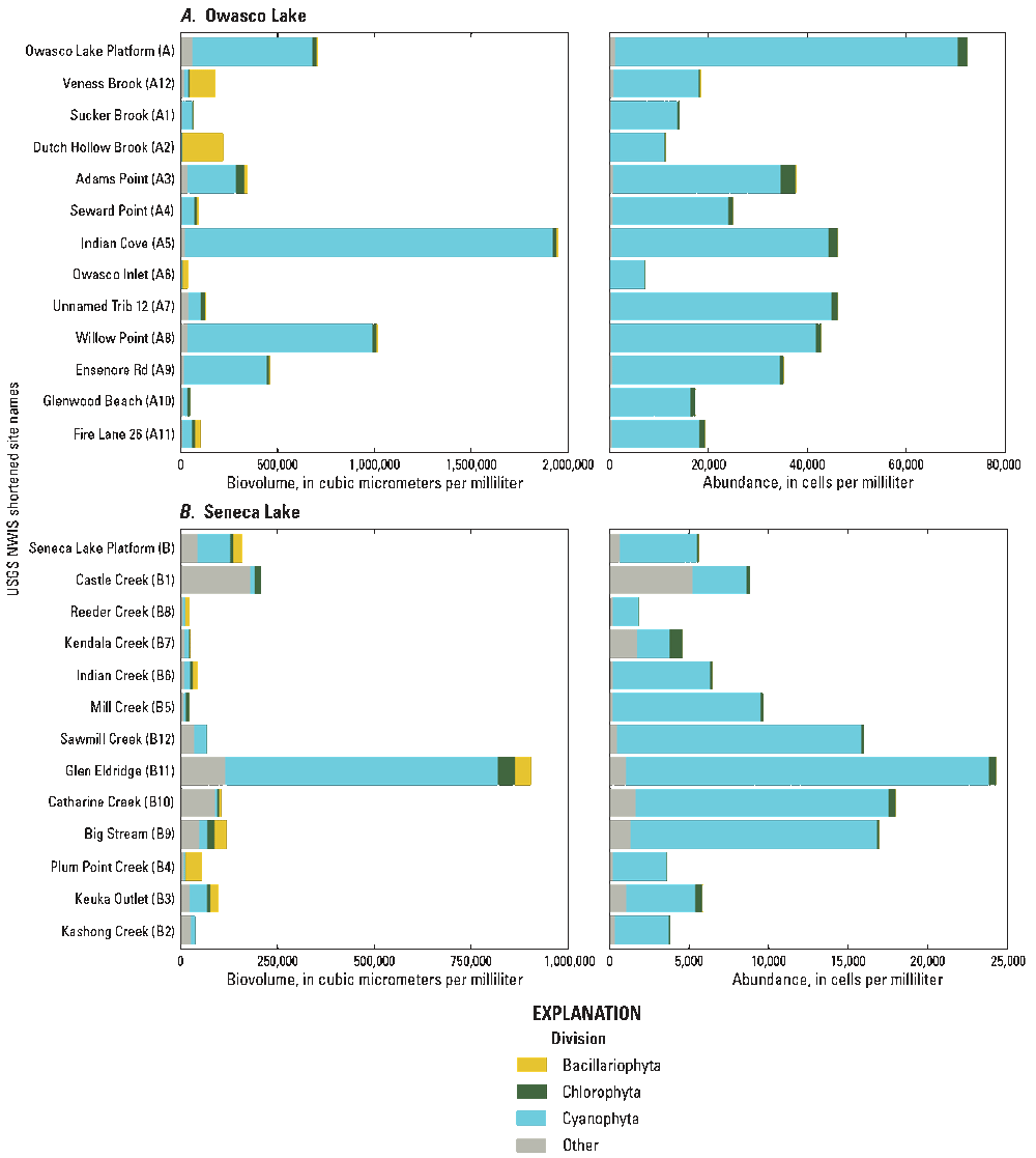
Graphs showing total phytoplankton biovolume and abundance in water samples collected from open-water monitoring platforms and nearshore locations in A, Owasco Lake and B, Seneca Lake, New York, in October 2019. Samples collected from the open-water monitoring platforms were collected approximately 1 week before the nearshore survey was conducted. See table 1 for list of site identifiers (letter and number), full site name, and site numbers from the U.S. Geological Survey (USGS) National Water Information System database (NWIS) (U.S. Geological Survey, 2020).
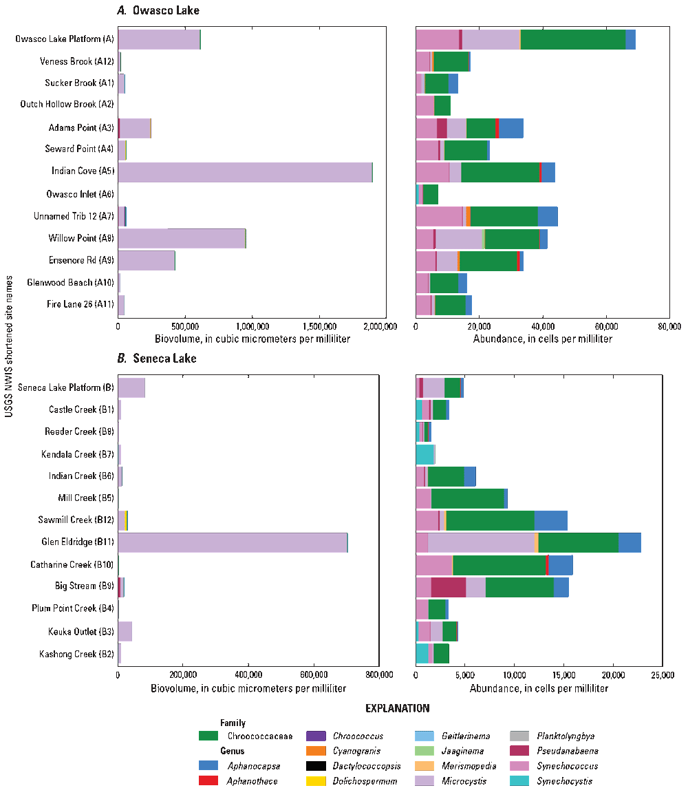
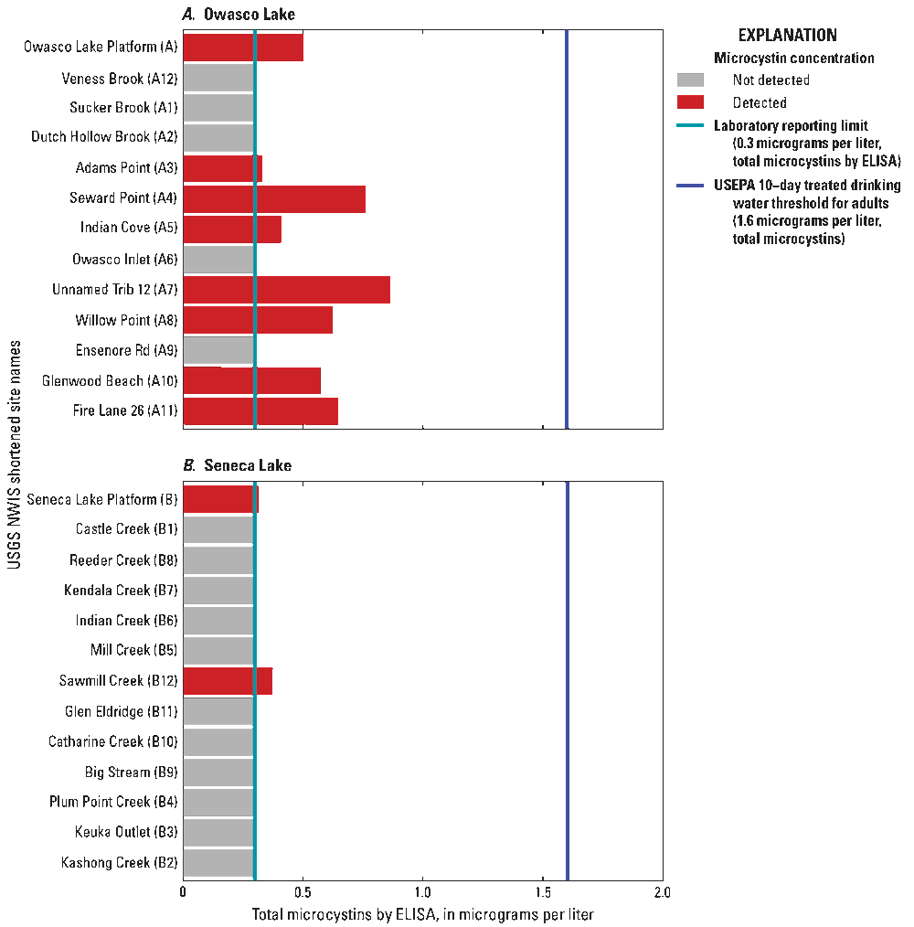
Graphs showing biovolume and abundance of cyanobacterial taxa and total microcystins in water samples collected from the open-water monitoring platforms and nearshore sampling locations in A, Owasco Lake and B, Seneca Lake, New York, in October 2019. Microcystin concentrations below laboratory reporting limits were substituted with the reporting limit of 0.3 micrograms per liter (µg/L). Lines correspond to the laboratory reporting limit and U.S. Environmental Protection Agency (U.S. EPA) 10-day treated drinking-water threshold for adults (1.6 µg/L total microcystins), respectively. See table 1 for list of site identifiers (letter and number), full site name, and site numbers from the U.S. Geological Survey (USGS) National Water Information System database (NWIS) (U.S. Geological Survey, 2020). ELISA, enzyme-linked immunosorbent assay.
Cyanobacterial community compositions in the nearshore samples from Owasco Lake were largely similar to the communities observed at the monitoring platform in the days prior to the nearshore survey (fig. 4A). However, two nearshore sites had higher cyanobacterial biovolume (attributed to Microcystis) than the open-water sample (619,519 µm3/mL biovolume): Indian Cove (A5) was 3.07 times higher, and Willow Point (A8) was 1.54 times higher (table 1; fig. 4A). In addition to the spatial heterogeneity characteristic of open-water algal community dynamics, the higher cyanobacterial biovolumes at the nearshore sites may be further attributed to the commonly observed nature of cyanobacteria to accumulate along shorelines due to wind and wave action. The NYSDEC received reports of CyanoHABs in Owasco Lake in early October 2019, but the location of these reports did not coincide with either the Indian Cove (A5) or Willow Point (A8) sites (table 1; fig 2A; NYSDEC, 2023).
The total phytoplankton abundance measured at the monitoring platform in Seneca Lake on October 3, 2019, was 5,610 cells/mL (159,545 µm3/mL), and cyanobacterial abundance was 4,851 cells/mL (84,260 µm3/mL; fig. 3). Cyanobacteria dominated the phytoplankton community present at the monitoring platform (87 percent cell abundance; 53 percent biovolume; fig. 3). Microcystis comprised 52 percent of cyanobacterial biovolume (fig. 4A). This pattern was largely representative of the results of the phytoplankton communities in the samples collected during the nearshore survey the following week. In the nearshore samples, cyanobacteria made up 39 to 96 percent (median 90 percent; n=12) of the cell abundance and 6 to 78 percent of biovolume (median 27.6 percent; n=12). Overall, 2 of 12 nearshore samples had biovolumes of cyanobacteria greater than or equal to 50 percent. Cyanobacterial biovolumes ranged from 3,791 to 704,143 µm3/mL (median 11,759 µm3/mL) and cell counts ranged from 1,614 to 22,809 cells/mL (median 5,214 cells/mL; n=12; fig. 4A).
Overall, phytoplankton and cyanobacterial abundance and biovolume were about five times higher in Owasco Lake relative to Seneca Lake, as suggested by higher chlorophyll concentrations in Owasco Lake. The results of the phytoplankton and cyanobacteria community composition analyses from the monitoring platforms were within the range of values observed across nearshore discrete samples collected in concert with the October 2019 surveys. Thus, in the absence of lakewide or nearshore CyanoHABs, the open-water snapshot from the platform was largely representative of the broader spatial heterogeneity present in the nearshore samples despite the time offset associated with sample collection.
The number of cyanobacterial genera and potential microcystin-producing genera present were determined using methods in Graham and others (2008) and Bernard and others (2017), and were comparable between Owasco (total: n=15; potential producers: n=8) and Seneca Lakes (total: n=12; potential producers: n=6). Microcystis comprised the bulk of the cyanobacterial biovolume in the samples collected (fig. 4A). On both lakes, Microcystis, Synechococcus, Aphanocapsa, and Pseudanabaena were the most commonly detected potential microcystin-producing genera in most samples and were the most abundant cyanotoxin-producing genera when present (fig. 4A). A small-celled taxon that could only be identified down to the family level as Chroococcaceae was also found in every sample from both lakes and contributed substantially to the cyanobacterial abundance, but not biovolume estimates.
The only monitoring platform sample that had detectable microcystins by ELISA (0.50 µg/L) from Owasco Lake was collected on October 2, 2019 (fig. 4B). However, microcystins were not detected by LCMS or LCMS/MS above the detection limit (0.37 µg/L) in this sample. This toxin detection occurred five days prior to the NYSDEC receiving reports of CyanoHABs on the shoreline of Owasco Lake (October 7, 2019; NYSDEC, 2023). During the October 2019 nearshore survey, 7 of 12 samples collected had concentrations of microcystins ranging from 0.331 to 0.863 µg/L (median: 0.623 µg/L; n=7) via ELISA but were not above detection limits by LCMS or LCMS/MS (Water Quality Portal, 2021).
Similar to Owasco Lake, the only monitoring platform sample from Seneca Lake that had detectable microcystins by ELISA (0.32 µg/L) was collected on October 3, 2019 (fig. 4B). Total microcystins were detected by ELISA in only one nearshore sample at the Sawmill Creek (B12) site (0.38 µg/L; table 1). The NYSDEC received nearshore CyanoHABs reports that they designated as “confirmed with high toxins” blooms in proximity to the monitoring platform and Sawmill Creek in early October 2019 (NYSDEC, 2023). Microcystins were not detected above LCMS/MS detection limits in any samples collected from Seneca Lake in October 2019 (Water Quality Portal, 2021).
Detectable concentrations of microcystin were not consistently associated with samples with the highest cyanobacterial biovolume or cell counts on either lake (fig. 4). When microcystin was detected in nearshore samples, it was also detected at the monitoring platform. NYSDEC confirmed the presence of shoreline accumulations containing high concentrations (greater than 20 µg/L) of microcystins within days of the nearshore surveys conducted in this study, but none of the open-water or nearshore samples collected in October 2019 exceeded either the Alert Level 2 guideline of 8,000,000 µm3/mL biovolume in the recreational Alert Level Framework for blooms dominated by cyanobacteria (Chorus and Welker, 2021), or the EPA drinking-water 10-day health advisory threshold for adults (1.6 µg/L total microcystin) in drinking water (U.S. Environmental Protection Agency, 2015; NYSDEC, 2023). These results highlight the spatiotemporal variability of cyanobacterial populations and complexities associated with monitoring CyanoHABs, both of which have been demonstrated in neighboring Finger Lakes (Prestigiacomo and others, 2023).
Nearshore Algal Biomass and Nitrate
The results from the nearshore surveys of Owasco Lake and Seneca Lake reveal areas of enrichment of nitrate and chlorophyll and highlight seasonal variability of spatial patterns in these constituents. The 75th percentile concentration for a given analyte per each nearshore survey was used as a threshold value for visualizations associated with these mapping efforts. Areas where values were greater than or equal to the 75th percentile were selected for evaluation in relation to watershed characteristics of nearby tributary mouths, phytoplankton abundance, and total microcystin concentrations to illustrate the utility of nearshore mapping to identify potential nutrient loading beyond what can be captured by routine tributary sampling and areas with localized CyanoHABs.
Gaps in nearshore data coverage occurred when the boats began traveling prior to the stabilization of the water-quality instrumentation during each of the summer surveys. Because gaps in nearshore coverage may subsequently affect 75th percentile thresholds for determining enrichment of nitrate and chlorophyll, gaps in nearshore data coverage are noted within affected descriptions of nearshore results.
Nitrate
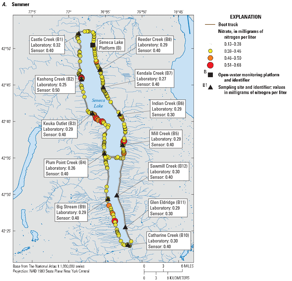
Nearshore mapping conducted in Owasco Lake identified areas of nitrate enrichment that varied seasonally (fig. 5). Nitrate concentrations above the 75th percentile value (1.11 mg/L as N) during the summer survey occurred along the southeasternmost shoreline of the lake, in the vicinity of Owasco Inlet (A6) and Indian Cove (A5), and along the western shoreline (table 1; fig. 5A). During the summer survey in Owasco Lake, nitrate concentrations were not measured in the southwest corner of the lake, approximately between Owasco Inlet (A6) and Willow Point (A8) (table 1; fig. 5A). Results from the vicinity of Dutch Hollow Brook (A2), Willow Point (A8), and Ensenore Road (A9) tributaries suggest localized tributary inputs may be affecting nearshore nitrate concentrations in Owasco Lake (table 1; fig. 5A). Findings from a concurrent NYSDEC study in the Owasco Lake watershed indicated that Owasco Inlet and Dutch Hollow Brook had elevated nitrate concentrations compared to other tributaries in the watershed in 2019 (NYSDEC, 2023). Furthermore, Owasco Inlet and Dutch Hollow Brook were identified in a previous investigation as primary contributors of sediment and nutrient loading to Owasco Lake (Halfman and others, 2019, 2023). The towns of Groton and Moravia discharge treated wastewater to Owasco Lake Inlet several miles upstream from where it discharges into Owasco Lake. Historically, the wastewater from these towns was a major source of phosphorus and nitrogen to Owasco Lake Inlet (Bode and others, 2007; Smith and others, 2012). The wastewater infrastructure for Groton and Moravia has undergone upgrades to provide advanced removal of phosphorus (EcoLogic LLC and Anchor QEA LLC, 2022b). The size of the Sucker Brook (A1) watershed approaches that of Owasco Inlet and Dutch Hollow Brook (table 1; fig 2A); however, nitrate concentrations measured by the NYDEC in 2019 in Sucker Brook were markedly lower than that of Owasco Inlet and Dutch Hollow Brook. In this study, nitrate concentrations recorded in the vicinity of Sucker Brook did not exceed 75th percentile concentrations during either survey (fig. 5).
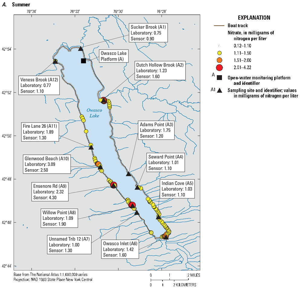
Maps showing nitrate concentrations in Owasco Lake, New York, as measured during continuous nearshore surveys and paired discrete near-surface sensor measurements and laboratory measurements from A, June 26, 2019 (Summer), and B, October 8, 2019 (Fall). Nitrate concentrations above the 75th percentile are shown as colored points. See table 1 for list of site identifiers (letter and number), full site name, and site numbers from the U.S. Geological Survey (USGS) National Water Information System database (NWIS) (U.S. Geological Survey, 2020).
Some smaller tributaries were associated with areas of nearshore nitrate enrichment, and the highest nitrate concentrations in the laboratory-analyzed samples were collected during the summer survey on Owasco Lake (fig. 5A). The highest nitrate concentrations in Owasco Lake were measured at the Glenwood Beach (A10) and Ensenore Road (A9) sites (discrete samples: 3.09 and 2.32 mg/L as N, respectively; discrete sensor measurements: 2.50 and 4.30 mg/L as N, respectively; table 1; fig. 5A). The smaller watershed outlets near these sites were not previously identified as areas of potential nitrate enrichment prior to the nearshore surveys, thereby suggesting the utility of the survey methods to document previously unidentified sources of constituents such as nitrate to larger water bodies. Although this finding is interesting, smaller contributing watersheds, such as those near the Glenwood Beach (A10) and Ensenore Road (A9) sites, likely contribute less total nitrate by mass to Owasco Lake than larger tributaries.
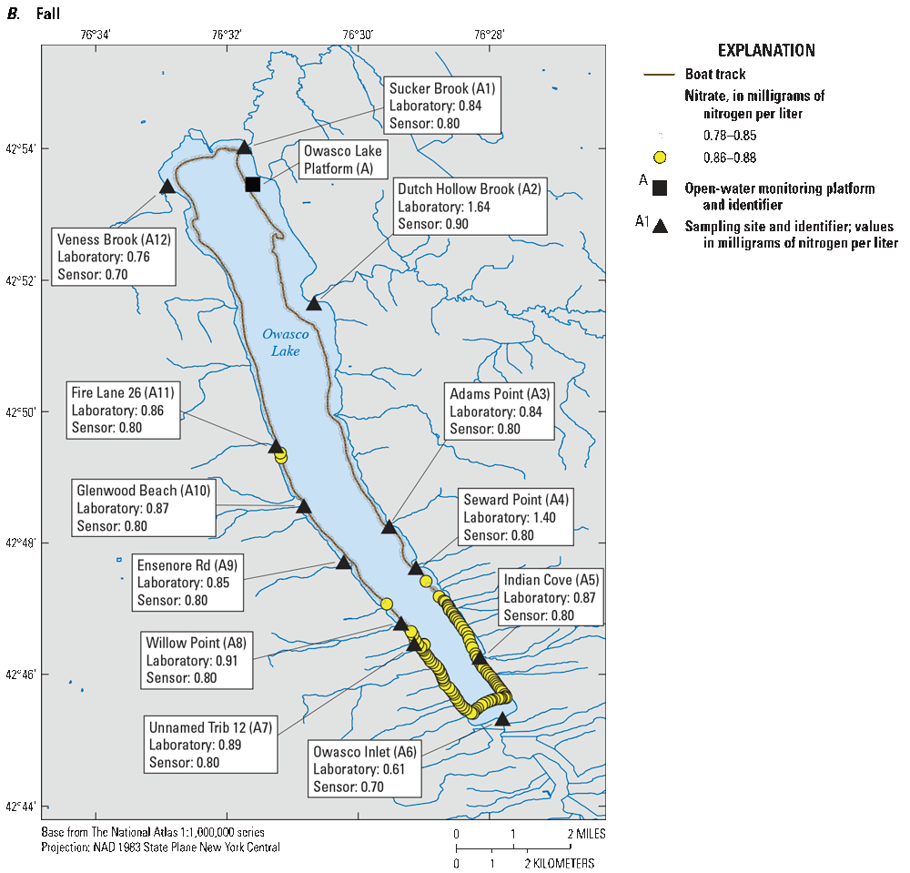
In contrast, nitrate concentrations in Owasco Lake during the fall survey were less variable (fig. 5B). Nitrate concentrations exceeded 75th percentile values only in the southernmost area of Owasco Lake in the vicinity of Owasco Inlet (A6) and Indian Cove (A5) (table 1; fig. 5B). The shoreline area in the vicinity of Indian Cove was previously identified by NYSDEC as an area of interest relative to potential failing septic systems in developed areas and documented occurrence of CyanoHABs (NYSDEC, 2018a). Thus, our findings may be indicative of nonpoint-source contributions of nitrate at the time of nearshore surveys, which were at low discharge conditions. The highest values from laboratory-analyzed nitrate samples from the fall survey on Owasco Lake were collected at the Dutch Hollow Brook (A2) and Seward Point (A4) sites (1.64 and 1.40 mg/L as N, respectively), although comparable nitrate concentrations were not observed in the nearshore survey data or discrete sensor measurements (table 1; fig. 5B). Discrepancies between laboratory-analyzed and nearshore survey measurements may be attributed to nearshore survey data being collected at distances greater than or equal to 100 m from shore because fog reduced visibility on the morning of October 8, 2019 (fig. 5B). Discrepancies between discrete laboratory-analyzed and discrete sensor measurements of nitrate may be attributed to uneven mixing of tributary waters enriched with nitrate and less nitrate-enriched lake water near the tributary outlets.
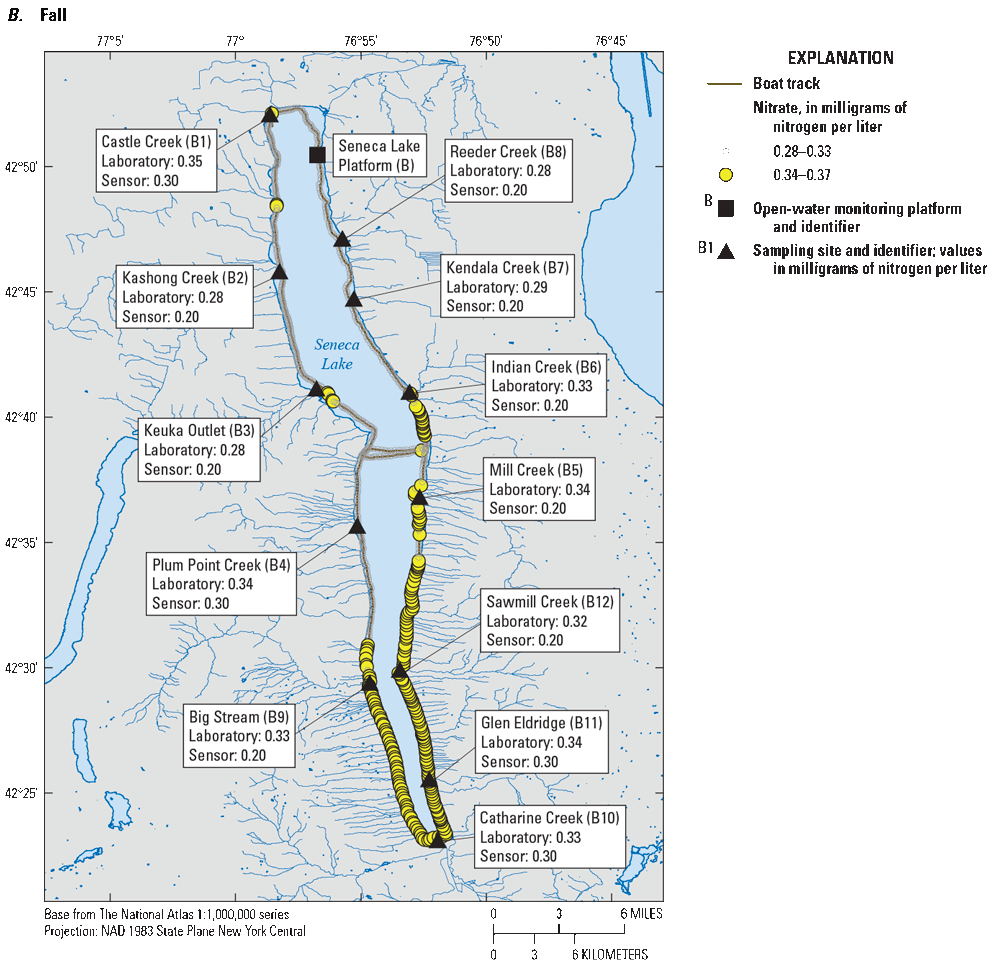
Maps showing nitrate concentrations in Seneca Lake, New York, as measured during continuous nearshore surveys and paired discrete near-surface sensor measurements and laboratory measurements from A, July 9 to 10, 2019 (Summer), and B, October 9 to 10, 2019 (Fall). Nitrate concentrations above the 75th percentile are shown as colored points. See table 1 for list of site identifiers (letter and number), full site name, and site numbers from the U.S. Geological Survey (USGS) National Water Information System database (NWIS) (U.S. Geological Survey, 2020).
Results from nearshore mapping in Seneca Lake revealed several areas of nitrate enrichment (fig. 6), albeit at relatively low overall concentrations compared to Owasco Lake. In Seneca Lake during July 2019, nitrate concentrations above the 75th percentile value (0.39 mg/L as N) occurred along much of the shoreline (fig. 6A). Individual measurements that were above the 75th percentile value spanned a narrow range in concentration (0.39 to 0.68 mg/L as N). Despite the narrow range of nitrate concentrations, the summer survey identified several locations where nitrate concentrations may indicate inputs from nearby tributaries. Nitrate concentrations more than 0.50 mg/L as N tended to occur in proximity to major tributaries. Readings in the vicinity of Keuka Outlet (B3) had higher nitrate concentrations than surrounding waters (table 1; fig. 6A). Keuka Outlet has previously been identified as a source of nitrate into Seneca Lake (Halfman, 2011; NYSDEC, 2023). The readings recorded in the vicinity of Kashong Creek (B2) and Big Stream (B9) also suggest localized inputs of nutrients to Seneca Lake (table 1; fig. 6A); this finding was substantiated by data collected from these tributaries in 2019 by the NYSDEC (NYSDEC, 2023), and by Halfman (2011). Furthermore, the Penn Yann Wastewater Treatment Plant discharges treated wastewater into Keuka Outlet, and the Dundee Wastewater Treatment Plant discharges treated wastewater into Big Stream, upstream of the respective stream outlets into Seneca Lake. In contrast, Castle Creek and Reeder Creek have comparatively smaller total watershed areas than Keuka Outlet, Kashong Creek, and Big Stream, and lower nitrate concentrations (NYSDEC, 2023). Although many of the highest measurements recorded in July coincided with the locations of major tributaries (Keuka Outlet [B3], Kashong Creek [B2], Indian Creek [B6], Big Stream [B9]; table 1; fig. 6A), the differences were small between nitrate concentrations identified by nearshore sampling and discrete sensor measurements and the median concentration of nitrate associated with the nearshore survey dataset (0.10 to 0.20 mg/L as N; table 3). The survey dataset had overall low variability relative to the resolution of the sensor used in the survey (0.1 mg/L as N).
During the fall survey in Seneca Lake, nitrate concentrations exceeded the 75th percentile concentration (0.34 mg/L as N) most frequently along the southern shoreline (fig. 6B). Nitrate concentrations along the southern shoreline were more homogenous, with a narrow range in values (0.34 to 0.45 mg/L as N), suggesting an absence of marked tributary influence. The narrow range of nitrate concentrations detected may also be attributed to lower overall tributary inflows during the week preceding the survey.
Chlorophyll
The findings of the nearshore surveys of chlorophyll in Owasco Lake underscored the utility of these methods to identify distinct areas where chlorophyll concentration patterns may indicate algal and cyanobacterial biomass in the nearshore environment (fig. 7). Results from the summer survey revealed two distinct areas of elevated chlorophyll concentrations relative to the rest of Owasco Lake (fig. 7A). Most of the readings that were above the 75th percentile value (1.46 µg/L of chlorophyll) occurred within clearly defined stretches along the southernmost shoreline and along the northeastern shoreline near the outlets of Sucker Brook (A1) and Veness Brook (A12) (table 1; fig. 7A). The nearshore sample results (2.3 to 21.7 µg/L of chlorophyll-a) in these areas confirmed the survey results. Observed chlorophyll concentrations along the northeastern shoreline of Owasco Lake in June 2019 had corresponding nitrate concentrations that were relatively low compared to other nearshore areas.
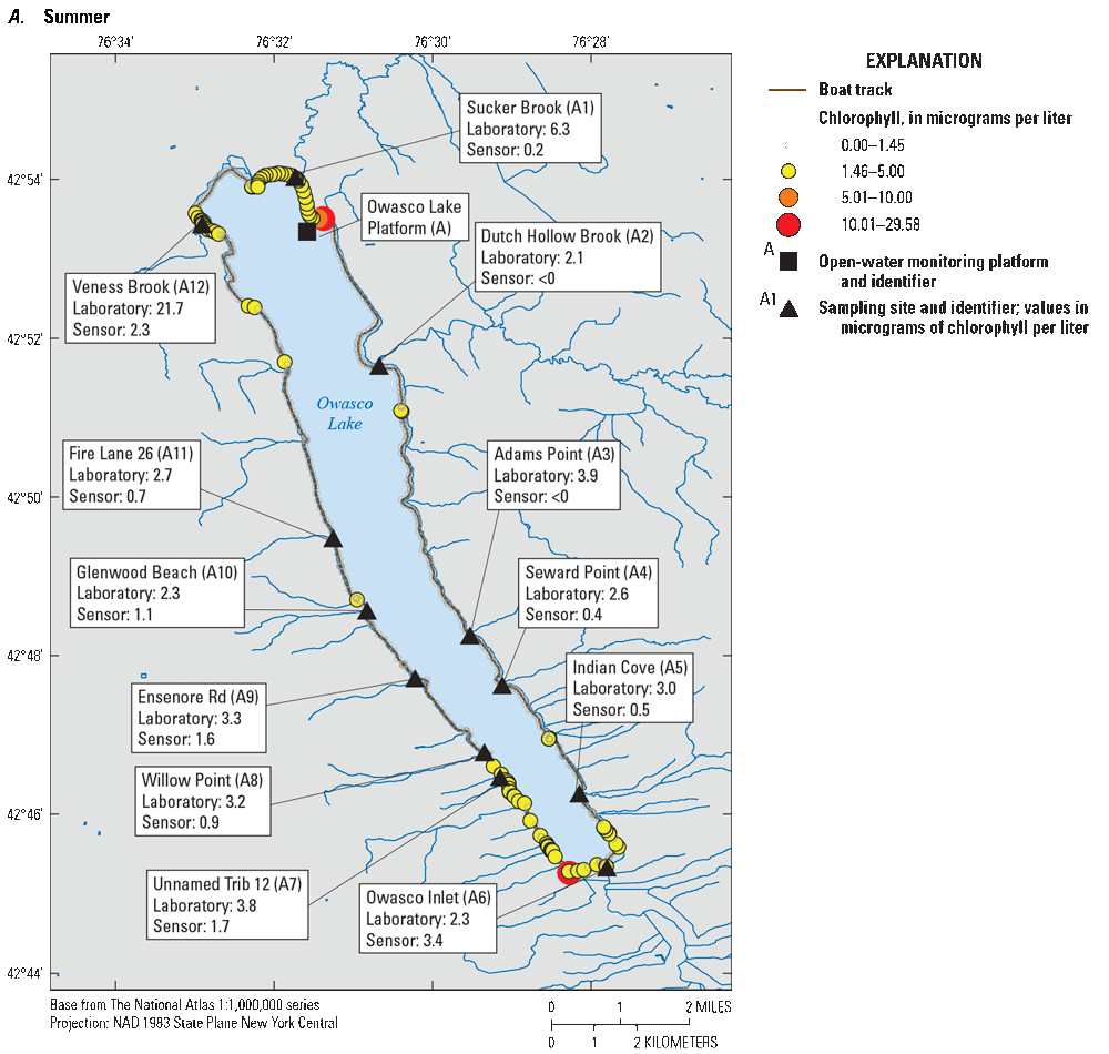
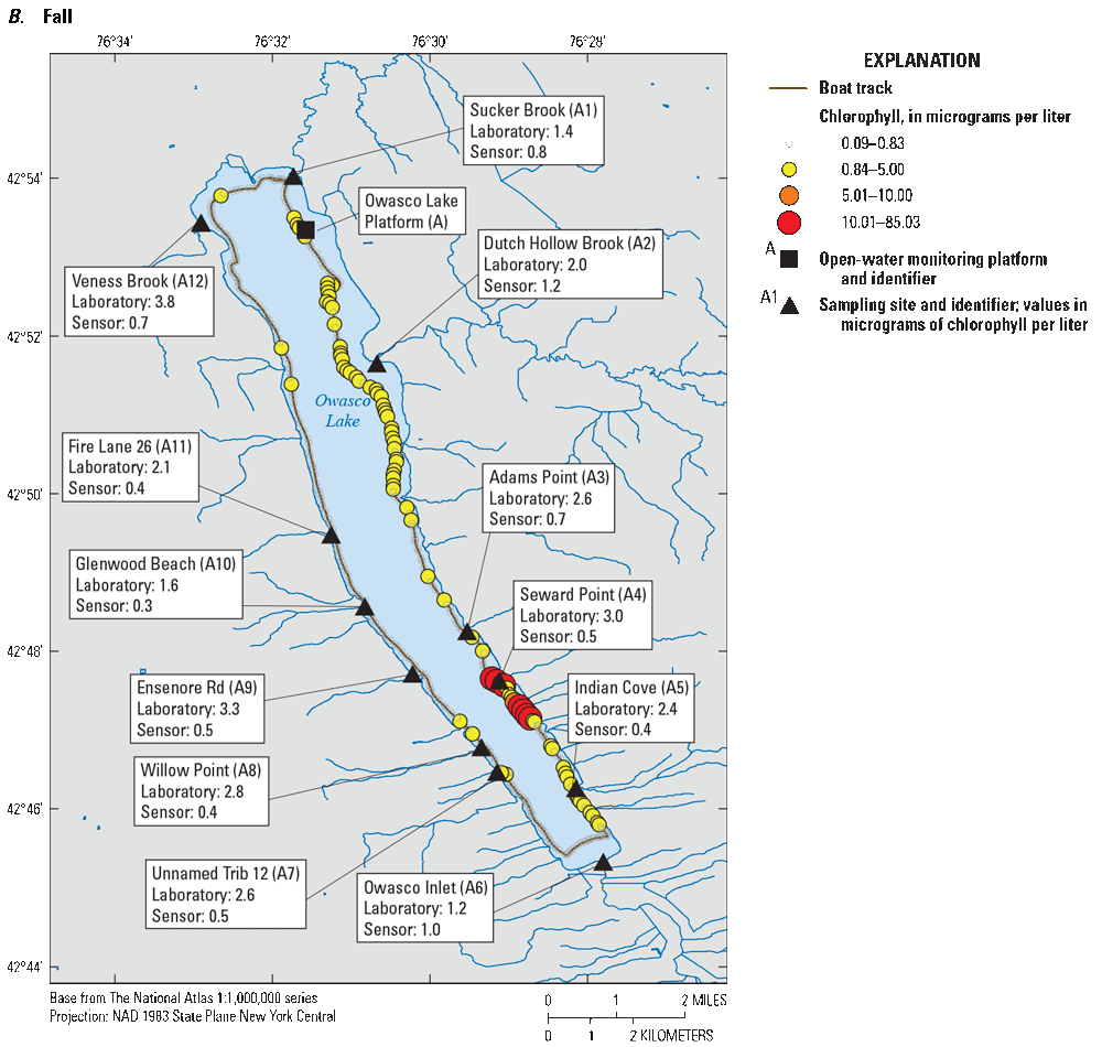
Maps showing chlorophyll concentrations in Owasco Lake, New York, as measured during continuous nearshore surveys and paired discrete near-surface sensor measurements and laboratory measurements from A, June 26, 2019 (Summer) and B, October 8, 2019 (Fall). Chlorophyll concentrations above the 75th percentile are shown as colored points. Negative concentrations (less than zero; <0) were censored at 0 µg/L. See table 1 for list of identifiers and corresponding site names and numbers; U.S. Geological Survey (2020).
During the October 2019 survey, chlorophyll concentrations above the 75th percentile concentration (0.84 µg/L) were primarily located along the eastern shoreline, with the highest concentrations associated with the southeastern shoreline approximately between Adams Point (A3) and Indian Cove (A5) (table 1; fig. 7B). The nearshore sample results from Adams Point (A3), Seward Point (A4), and Indian Cove (A5) during this survey were similarly high (table 1; fig. 7B). Mapping of chlorophyll concentrations relative to nearshore CyanoHAB formation is generally supported by phytoplankton biovolume and abundance results from the discrete sample sites. The highest phytoplankton biovolume and abundance in any sample collected during the fall survey on Owasco Lake was from Indian Cove (A5) (table 1; fig. 3). Microcystin was detected in samples collected at Adams Point (A3), Seward Point (A4), and Indian Cove (A5) in October 2019 (table 1; fig. 4B). On the southwestern shore, the Unnamed Trib[utary] 12 (A7) and Willow Point (A8) sites were similarly associated with cooccurrences of nearshore survey measurements of chlorophyll above the 75th percentile, elevated chlorophyll-a concentrations in laboratory-measured samples, higher abundances of phytoplankton and cyanobacteria relative to other sites, and detections of microcystins. Like the summer survey, the highest value from a laboratory-analyzed chlorophyll-a sample from the fall survey on Owasco Lake was collected at the Veness Brook (A12) site (3.82 µg/L chlorophyll-a; table 1; fig. 7B), although comparable concentrations were not measured in the nearshore survey data or the paired discrete chlorophyll sensor measurement (0.67 µg/L). Discrepancies between laboratory-analyzed and nearshore survey measurements again may be attributed to (1) nearshore survey data being collected at distances too great to capture site conditions closer to the tributary outlet where sample collection occurred; or (2) the discrepancies may be an artifact of the precision of sample collection methods relative to the ephemeral nature of lake systems; or (3) because concentrations of chlorophyll reported by algal fluorometers are based upon indirect, or proxy-based, measurements of the fluorescence response of algal pigments in water at a specific absorption wavelength, and the concentrations reported by the sensors extrapolated from those measurements may or may not necessarily be directly proportional to the concentration of algal pigments in water (Foster and others, 2022).
Chlorophyll concentrations measured during nearshore surveys of Seneca Lake exhibited spatial patterns that were similar among surveys (fig. 8). Nearshore surveys in Seneca Lake in summer resulted in a narrow range of chlorophyll concentrations, with a 75th percentile concentration of 0.74 µg/L of chlorophyll (fig. 8A). Chlorophyll concentrations were not recorded in the northwest corner of Seneca Lake, approximately between Castle Creek (B1) and Kashong Creek (B2), on July 9, 2019, and also not recorded midway along the western shore between Plum Point Creek (B4) and Big Stream (B9) on July 10, 2019 (table 1; fig. 8A). The maximum laboratory-measured concentration of chlorophyll-a associated with July 2019 surveys on Seneca Lake (3.23 µg/L) occurred at Catharine Creek (B10; table 1). Catharine Creek was associated with a part of the shoreline where chlorophyll concentrations exceeded 75th percentile values of the nearshore dataset for July 2019 (fig. 8A). Comparisons of laboratory-analyzed chlorophyll-a concentrations with other parts of the Seneca Lake shoreline where nearshore data exceeded 75th percentile concentrations showed mixed agreement. Chlorophyll concentrations were generally below 75th percentile thresholds along the eastern shoreline of Seneca Lake. The overall low concentration ranges of chlorophyll limited insights into the causes of variations along the shoreline and may simply indicate that the variations are not ecologically meaningful.
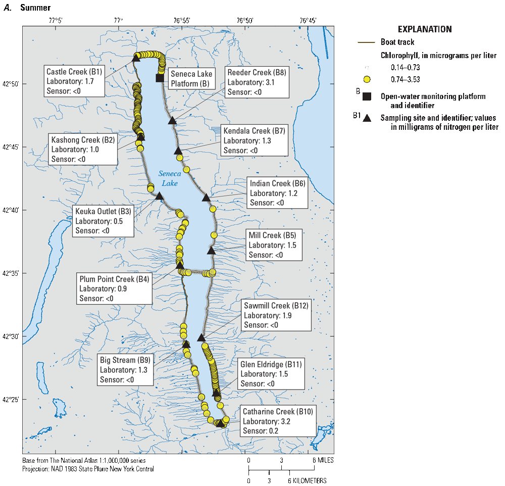
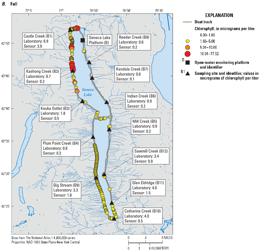
Maps showing chlorophyll concentrations in Seneca Lake, New York, as measured during continuous nearshore surveys and paired discrete near-surface sensor measurements and laboratory measurements from A, July 9 to 10, 2019 (Summer) and B, October 9 to 10, 2019 (Fall). Chlorophyll concentrations above the 75th percentile are shown as colored points. Negative concentrations (less than zero; <0) were censored at 0 µg/L. See table 1 for list of identifiers and corresponding site names and numbers; U.S. Geological Survey (2020).
Chlorophyll concentrations measured during the fall survey in Seneca Lake varied by several orders of magnitude and were largely similar in distribution around Seneca Lake as those found in the summer survey (fig. 8B). The highest concentrations of chlorophyll in the fall were detected along the northwesternmost and southwest shorelines of Seneca Lake. The highest chlorophyll concentration (77.52 µg/L) was observed in the vicinity of the outlet of Kashong Creek (B2) (table 1; fig. 8B). Shoreline CyanoHABs were reported to the NYSDEC along the shoreline south of Kashong Creek on October 1 and 7, 2019 (NYSDEC, 2023). However, phytoplankton community composition from the discrete sample collected at the Kashong Creek (B2) site during the October survey was not associated with elevated concentrations of cyanobacteria (table 1; fig. 4A). The maximum laboratory-analyzed chlorophyll-a concentration associated with the fall survey of Seneca Lake (6.92 µg/L) occurred at Castle Creek (B1) and was associated with the area of similarly elevated chlorophyll concentrations identified from the nearshore survey (table 1; fig. 8B); however, biovolume and abundance were low in discrete samples collected from the Kashong Creek (B2) and Castle Creek (B1) sites relative to the rest of Seneca Lake (table 1; fig. 4A). The Catharine Creek (B10) outlet and surrounding waters along the southern shoreline of Seneca Lake were identified as an area where chlorophyll concentrations were consistently above the 75th percentile (table 1; fig. 8B). When compared to more northerly sites, Cyanophyta abundance was also elevated in samples collected from sites located along the southernmost shorelines of Seneca Lake in October 2019 (fig. 4A). This indicates that concentration ranges of chlorophyll observed during nearshore mapping of Seneca Lake conducted in October 2019 were adequate for identification of localized Cyanophyta occurrences, although abundances remained low. Furthermore, laboratory-measured chlorophyll-a concentrations showed general alignment with mapped areas of higher chlorophyll concentrations on Seneca Lake during October 2019 surveys.
Unlike optical nitrate sensors, which report direct measurements of concentration calculated from photometric measurements of ultraviolet light absorbance by ions in solution (Pellerin and others, 2013), concentrations of chlorophyll reported by algal fluorometers are based upon indirect, or proxy-based, measurements of the fluorescence response of algal pigments in water at a specific absorption wavelength (Foster and others, 2022). As a result, the concentrations reported by the sensors extrapolated from those measurements may or may not necessarily be directly proportional to the concentration of algal pigments in water. Additionally, fluorescence concentrations reported by algal fluorometers are subject to several confounding factors (Foster and others, 2022). These factors range from the biological (efficiency of various taxa to harness light, the overall health of an algal community), environmental (diurnal variability), and those related to the maintenance and calibration of the sensors. Collectively, these factors may affect the amount of algal pigment in a system, the ability of algal taxa to fluoresce, or the ability of a sensor to provide representative relative environmental concentrations (Foster and others, 2022). Although measurements of algal pigments, particularly chlorophyll, have become preferred for many studies and monitoring programs as a proxy for phytoplankton biomass, the relationship among laboratory-measured algal pigments and phytoplankton abundance or biovolume can vary substantially (Canfield and others, 2019).
Summary
The proliferation of cyanobacteria in aquatic ecosystems poses a serious water-quality concern. Periodic monitoring of cyanobacterial harmful algal blooms (CyanoHABs) is complicated by the inherent spatiotemporal variability of cyanobacteria, the ephemeral nature of cyanotoxins associated with CyanoHABs, and financial constraints posed by traditional analytical methods. Thus, high-resolution mapping surveys may be a reasonable alternative to discrete monitoring for identifying areas of cyanobacteria, chlorophyll, and nutrient concentrations. Since 2012, the New York State Department of Environmental Conservation (NYSDEC) has documented CyanoHABs in more than 400 waterbodies in New York State, including the Finger Lakes, which are important recreational, drinking-water, and economic resources for New York State. Two of the Finger Lakes—Owasco Lake and Seneca Lake—have recorded at least one CyanoHAB exceeding the NYSDEC “confirmed with high toxins” threshold(s). Owasco Lake has had at least one CyanoHAB exceeding the NYSDEC “confirmed with high toxins” threshold(s) recorded every year from 2013 to 2019, and on Seneca Lake, at least one CyanoHAB exceeding the NYSDEC “confirmed with high toxins” threshold(s) was recorded every year from 2015 to 2019.
The advanced monitoring pilot study is a collaboration among the U.S. Geological Survey (USGS), the New York State Department of Environmental Conservation (NYSDEC), and the New York State Department of Health aimed at developing and implementing a comprehensive monitoring strategy in select Finger Lakes that have been affected by CyanoHABs. This study assessed traditional and innovative approaches for understanding occurrences of CyanoHABs in two of the Finger Lakes with the goal of informing future monitoring strategies and improving the understanding of CyanoHABs in New York State. Nearshore mapping surveys were conducted on Owasco Lake and Seneca Lake using continuous water-quality instrumentation measurements to identify potential sources of nutrients that were not captured by tributary sampling, identify areas with localized nearshore CyanoHABs, and investigate whether water-quality information from high-resolution nearshore surveys was representative of open-water conditions.
Owasco Lake and Seneca Lake each had nearshore surveys conducted twice for this study. Discrete samples and paired near-surface sensor measurements from twelve targeted locations measuring nitrate and chlorophyll were also collected from Owasco Lake and Seneca Lake concurrent with the nearshore surveys. Additional samples were collected from both lakes for phytoplankton community identification, enumeration, and cyanotoxin analysis in October 2019. Continuous sensor data were collected at open-water, fixed-location, monitoring platforms on each of the study lakes. Discrete water-quality samples were collected at the monitoring platforms and analyzed for the same parameters as discrete nearshore samples, including phytoplankton identification, enumeration, and cyanotoxins. Water-quality data corresponding to monitoring platforms were used to assess how continuous sensor data compared to laboratory measurements and how well the monitoring platforms represented overall lake conditions. Data from determination of concentrations of nitrate and chlorophyll were summarized by methodology for each lake and survey effort to compare concentration ranges across methodologies and under different environmental conditions.
Median nitrate concentrations were higher during summer nearshore surveys in Owasco Lake across methods. Median nitrate concentrations did not vary consistently among methods or across seasons in Seneca Lake because concentrations typically spanned narrow ranges. Samples collected from both monitoring platforms had nitrate concentrations within the ranges produced by nearshore surveys.
Chlorophyll concentrations in Owasco Lake were generally higher during summer nearshore surveys regardless of methodology. Comparisons of median chlorophyll concentrations across methodologies in Seneca Lake produced mixed results with no clear distinction between survey dates. Chlorophyll concentrations measured at both monitoring platforms were also within the ranges produced by nearshore surveys on both lakes. Discrete sensor measurements of chlorophyll concentrations spanned narrower ranges than results produced by nearshore surveys on Owasco Lake and Seneca Lake. Overall, median chlorophyll concentrations observed in this study were less than 3 µg/L across methodologies, with notable exceptions observed during nearshore surveys and at the open-water monitoring platform on Owasco Lake during the summer survey. Laboratory-analyzed discrete samples of chlorophyll-a concentrations were typically higher than paired discrete sensor measurements. Despite several relatively high chlorophyll concentrations measured during nearshore surveys, median chlorophyll concentrations were generally comparable across methods.
Cyanobacteria dominated the phytoplankton community at the monitoring platforms and in about half of the discrete samples that were collected during the nearshore surveys of Owasco Lake and Seneca Lake. Microcystis was present in nearly all discrete samples collected from Owasco Lake in October 2019 and comprised the bulk of the total cyanobacterial biovolume in most samples collected from both lakes. Microcystis, Synechococcus, Aphanocapsa, and Pseudanabaena were the most-detected potential microcystin-producing genera in most of the samples collected from Owasco and Seneca Lakes. Results of the cyanobacterial community composition analyses from the monitoring platforms were within the range of values observed across discrete nearshore samples collected concurrently with October 2019 nearshore surveys in Owasco and Seneca Lakes. Total microcystin, as measured by enzyme-linked immunosorbent assay (ELISA), was detected in a single discrete sample collected on Seneca Lake and in seven discrete samples collected in Owasco Lake during the fall surveys. Detectable concentrations of microcystin were not consistently associated with those samples with the greatest cyanobacterial cell counts; however, when microcystin was detected in discrete nearshore samples, it was also detected in samples at the monitoring platforms.
Nearshore mapping conducted in Owasco Lake showed areas of nitrate enrichment that varied seasonally. Nitrate concentrations above the 75th percentile during summer in Owasco Lake primarily occurred along the southeasternmost and western shorelines. Higher nitrate concentrations coinciding with the outlets of major tributaries suggest that tributary inputs may be affecting nearshore nitrate concentrations in Owasco Lake. Several of the tributaries near areas of nitrate enrichment identified in the nearshore surveys had been identified previously as primary contributors of sediment and nutrient loading into Owasco Lake. Nitrate concentrations in Owasco Lake during the fall survey were less variable but still were able to indicate areas of nitrate enrichment consistent with prior investigations.
Results from nearshore mapping conducted in Seneca Lake revealed several areas of nitrate enrichment, albeit at concentrations that would generally be considered low. Despite the narrow range in nitrate concentrations associated with nearshore surveys of Seneca Lake conducted in July 2019, several locations were identified where nitrate concentrations may indicate localized inputs from tributaries. Areas of enrichment in nitrate concentrations tended to occur in proximity to the lakeshore near outlets of major tributaries into Seneca Lake and varied between survey dates.
Chlorophyll mapping efforts in Owasco Lake in June 2019 revealed two distinct areas of high chlorophyll concentration relative to other parts of Owasco Lake, with most of these areas occurring within clearly defined stretches of the southernmost shoreline and at the outlet of certain tributaries. During the October 2019 survey, the highest chlorophyll concentrations were largely constrained to the eastern shoreline of Owasco Lake. When compared to phytoplankton abundance and biovolume analyzed in discrete samples, chlorophyll concentrations measured during nearshore surveys typically covaried with biovolume and abundance; however, the concentration ranges observed in nearshore data were not always proportional to those of chlorophyll concentrations from discrete samples.
Chlorophyll concentrations that were measured during nearshore surveys of Seneca Lake exhibited patterns that were comparable across survey dates. Chlorophyll mapping in Seneca Lake in July 2019 showed narrow ranges of chlorophyll concentrations, limiting the ability to identify meaningful differences in chlorophyll concentrations along the shoreline. Chlorophyll concentration patterns along the northwesternmost and southwestern stretches of shoreline in July 2019 were largely the same as those in the October 2019 survey, but generally were more extensive and exhibited higher concentrations of chlorophyll. Phytoplankton and Cyanophyta biovolume and cell abundances in discrete samples that were collected in proximity to the northernmost shoreline where the nearshore survey data indicated the highest measurements of chlorophyll did not mirror the pattern of chlorophyll concentrations from the survey.
General patterns of nearshore concentrations of nitrate and chlorophyll associated with nearshore mapping were supported by previous investigations of tributary loading and loosely covary with increases in chlorophyll concentrations measured in discrete samples and in phytoplankton abundance and community composition. However, there was not universal agreement in the nearshore sensor measurements and laboratory results, which may be attributed to the small range in observed concentrations and further complicated by the ephemeral nature of cyanobacteria and associated biogeochemical cycles within lake systems.
References Cited
Anderson, D.M., Glibert, P.M., and Burkholder, J.M., 2002, Harmful algal blooms and eutrophication: Nutrient sources, composition, and consequences: Estuaries and Coasts, v. 25, no. 4b, p. 704–726, accessed June 2, 2023, at https://doi.org/10.1007/bf02804901.
Arar, E.J., and Collins, G.B., 1997, Method 445.0—In vitro determination of chlorophyll a and pheophytin a in marine and freshwater algae by fluorescence (revision 1.2, September 1997): U.S. Environmental Protection Agency, 22 p., accessed June 23, 2023, at https://cfpub.epa.gov/si/si_public_record_report.cfm?Lab=NERL&dirEntryId=309417.
Barnard, M.A., Chaffin, J.D., Plaas, H.E., Boyer, G.L., Wei, B., Wilhelm, S.W., Rossignol, K.L., Braddy, J.S., Bullerjahn, G.S., Bridgeman, T.B., Davis, T.W., Wei, J., Bu, M., and Paerl, H.W., 2021, Roles of nutrient limitation on western Lake Erie cyanoHAB toxin production: Toxins, v. 13, no. 1, article 47, 21 p., accessed June 2, 2023, at https://doi.org/10.3390/toxins13010047.
Bernard, C., Ballot, A., Thomazeau, S., Maloufi, S., Furey, A., Mankiewicz-Boczek, J., Pawlik-Skowrońska, B., Capelli, C., and Salmaso, N., 2017, Cyanobacteria associated with the production of cyanotoxins, in Meriluoto, J., Spoof, L., and Codd, G.A., eds., Handbook of cyanobacterial monitoring and cyanotoxin analysis: West Sussex, U.K., John Wiley & Sons Ltd, p. 501–525., accessed June 2, 2023, at https://doi.org/10.1002/9781119068761.
Bode, R.W., Novak, M.A., Abele, L.E., Heitzman, D.L., and Smith, A.J., 2007, Owasco Lake Inlet—Biological assessment—2006 survey: New York State Department of Environmental Conservation, 43 p., accessed June 12, 2023, at https://nysl.ptfs.com/aw-server/rest/product/purl/NYSL/s/6d6c1cda-ec9d-4b75-b2b9-93fcbabc23f1.
Booth, A., Fleck, J., Pellerin, B.A., Hansen, A., Etheridge, A., Foster, G.M., Graham, J.L., Bergamaschi, B.A., Carpenter, K.D., Downing, B.D., and Rounds, S.A., 2023, Field techniques for fluorescence measurements targeting dissolved organic matter, hydrocarbons, and wastewater in environmental waters—Principles and guidelines for instrument selection, operation and maintenance, quality assurance, and data reporting: U.S. Geological Survey Techniques and Methods, book 1, chap. D11, 41 p., accessed June 2, 2023, at https://doi.org/10.3133/tm1D11.
Boyer, G.L., 2007, The occurrence of cyanobacterial toxins in New York lakes—Lessons from the MERHAB-Lower Great Lakes program: Lake and Reservoir Management, v. 23, no. 2, p. 153–160, accessed June 23, 2023, at https://doi.org/10.1080/07438140709353918.
Boyer, G.L., 2020, LCMS–SOP determination of microcystins in water samples by high performance liquid chromatography (HPLC) with single quadrupole mass spectrometry (MS): Metabolomics Protocols & Workflows, 30 p., accessed June 23, 2023, at https://doi.org/10.17504/protocols.io.bck2iuye.
Brooks, B.W., Lazorchak, J.M., Howard, M.D.A., Johnson, M.-V.V., Morton, S.L., Perkins, D.A.K., Reavie, E.D., Scott, G.I., Smith, S.A., and Steevens, J.A., 2016, Are harmful algal blooms becoming the greatest inland water-quality threat to public health and aquatic ecosystems?: Environmental Toxicology and Chemistry, v. 35, no. 1, p. 6–13, accessed June 23, 2023, at https://doi.org/10.1002/etc.3220.
Callinan, C.W., 2001, Water-quality study of the Finger Lakes. New York State Department of Environmental Conservation, Division of Water, 152 p., accessed June 23, 2023, at https://nysl.ptfs.com/data/Library1/Library1/pdf/50277116.pdf.
Canfield, D.E., Jr., Bachmann, R.W., Hoyer, M.V., Johansson, L.S., Søndergaard, M., and Jeppesen, E., 2019, To measure chlorophyll or phytoplankton biovolume—An aquatic conundrum with implications for the management of lakes: Lake and Reservoir Management, v. 35, no. 2, p. 181–192, accessed June 23, 2023, at https://doi.org/10.1080/10402381.2019.1607958.
Carey, C.C., Ibelings, B.W., Hoffmann, E.P., Hamilton, D.P., and Brookes, J.D., 2012, Eco-physiological adaptations that favor freshwater cyanobacteria in a changing climate: Water Research, v. 46, no. 5, p. 1394–1407, accessed June 23, 2023, at https://doi.org/10.1016/j.watres.2011.12.016.
Carey, C.C., Weathers, K.C., and Cottingham, K.L., 2008, Gloeotrichia echinulata blooms in an oligotrophic lake—Helpful insights from eutrophic lakes: Journal of Plankton Research, v. 30, no. 8, p. 893–904, accessed June 23, 2023, at https://doi.org/10.1093/plankt/fbn055.
Chorus, I., and Welker, M., eds., 2021, Toxic cyanobacteria in water—A guide to their public health consequences, monitoring and management (2d ed.): CRC Press, London, 858 p. [Also available at https://doi.org/10.1201/9781003081449.]
Crawford, J.T., Loken, L.C., Casson, N.J., Smith, C., Stone, A.G., and Winslow, L.A., 2015, High-speed limnology—Using advanced sensors to investigate spatial variability in biogeochemistry and hydrology: Environmental Science & Technology, v. 49, no. 1, p. 442–450, accessed May 17, 2023, at https://doi.org/10.1021/es504773x.
Dewitz, J., 2023, National land cover database (NLCD) 2021 products: U.S. Geological Survey data release, accessed January 4, 2024, at https://doi.org/10.5066/P9JZ7AO3.
Downing, B.D., Bergamaschi, B.A., and Kraus, T.E.C., 2017, Synthesis of data from high-frequency nutrient and associated biogeochemical monitoring for the Sacramento-San Joaquin Delta, northern California: U.S. Geological Survey Scientific Investigations Report 2017–5066, 28 p., accessed May 17, 2023, at https://doi.org/10.3133/sir20175066.
Downing, J., Watson, S., and McCauley, E., 2001, Predicting cyanobacterial dominance in lakes: Canadian Journal of Fisheries and Aquatic Sciences, v. 58, no. 10, p. 1905–1908. https://doi.org/10.1139/f01-143.
EcoLogic LLC and Anchor QEA LLC, 2022a, Seneca-Keuka watershed—Nine element plan for phosphorus: Seneca Watershed Intermunicipal Organization, Keuka Watershed Improvement Cooperative, Seneca Lake Pure Waters Association, and Keuka Lake Association, prepared by EcoLogic LLC and Anchor QEA LLC, 326 p., accessed June 23, 2023, at https://www.dec.ny.gov/docs/water_pdf/senecakeuka9e.pdf.
EcoLogic LLC and Anchor QEA LLC, 2022b, Owasco Lake watershed nine element plan for phosphorus: Cayuga County Department of Planning and Economic Development, prepared by EcoLogic LLC and Anchor QEA LLC, 109 p., accessed June 23, 2023, at https://www.dec.ny.gov/docs/water_pdf/owasco9e22.pdf.
Favot, E.J., Holeton, C., DeSellas, A.M., and Paterson, A.M., 2023, Cyanobacterial blooms in Ontario, Canada—Continued increase in reports through the 21st century: Lake and Reservoir Management, v. 39, no. 1, p. 1–20, accessed June 23, 2023, at https://doi.org/10.1080/10402381.2022.2157781.
Fishman, M.J., ed., 1993, Methods of analysis by the U.S. Geological Survey National Water Quality Laboratory—Determination of inorganic and organic constituents in water and fluvial sediments: U.S. Geological Survey Open-File Report 93–125, 217 p., accessed June 23, 2023, at https://doi.org/10.3133/ofr93125.
Foster, G.M., Graham, J.L., Bergamaschi, B.A., Carpenter, K.D., Downing, B.D., Pellerin, B.A., Rounds, S.A., and Saraceno, J.F., 2022, Field techniques for the determination of algal pigment fluorescence in environmental waters—Principles and guidelines for instrument and sensor selection, operation, quality assurance, and data reporting: U.S. Geological Survey Techniques and Methods, book 1, chap. D10, 34 p., accessed June 23, 2023, at https://doi.org/10.3133/tm1D10.
Foster, G.M., Graham, J.L., and King, L.R., 2019, Spatial and temporal variability of harmful algal blooms in Milford Lake, Kansas, May through November 2016: U.S. Geological Survey Scientific Investigations Report 2018–5166, 36 p., accessed June 23, 2023, at https://doi.org/10.3133/sir20185166.
Foster, G.M., Graham, J.L., Stiles, T.C., Boyer, M.G., King, L.R., and Loftin, K.A., 2017, Spatial variability of harmful algal blooms in Milford Lake, Kansas, July and August 2015: U.S. Geological Survey Scientific Investigations Report 2016–5168, 45 p., accessed June 23, at https://doi.org/10.3133/sir20165168.
Francy, D.S., Graham, J.L., Stelzer, E.A., Ecker, C.D., Brady, A.M.G., Struffolino, P., and Loftin, K.A., 2015, Water quality, cyanobacteria, and environmental factors and their relations to microcystin concentrations for use in predictive models at Ohio Lake Erie and inland lake recreational sites, 2013–14: U.S. Geological Survey Scientific Investigations Report 2015–5120, 58 p. [Also available at https://doi.org/10.3133/sir20155120.]
Gibs, J., Wilde, F.D., and Heckathorn, H.A., 2012, Use of multiparameter instruments for routine field measurements: U.S. Geological Survey Techniques of Water-Resources Investigations, book 9, chap. A6, 48 p., accessed June 23, 2023, at https://doi.org/10.3133/twri09A6.8.
Glibert, P.M., and Burford, M.A., 2017, Globally changing nutrient loads and harmful algal blooms—Recent advances, new paradigms, and continuing challenges: Oceanography, v. 30, no. 1, p. 58–69, accessed June 23, at https://doi.org/10.5670/oceanog.2017.110.
Gorney, R.M., June, S.G., Stainbrook, K.M., and Smith, A.J., 2023, Detections of cyanobacteria harmful algal blooms (cyanoHABs) in New York State, United States (2012–2020): Lake and Reservoir Management, v. 39, no. 1, p. 21–36, accessed June 23, 2023, at https://doi.org/10.1080/10402381.2022.2161436.
Graham, J.L., Dubrovsky, N.M., and Eberts, S.M., 2016, Cyanobacterial harmful algal blooms and U.S. Geological Survey science capabilities, ver. 1.1, December 2017: U.S. Geological Survey Open-File Report 2016–1174, 12 p., accessed June 23, 2023, at https://doi.org/10.3133/ofr20161174.
Graham, J.L., Loftin, K.A., Ziegler, A.C., and Meyer, M.T., 2008, Guidelines for design and sampling for cyanobacterial toxin and taste-and-odor studies in lakes and reservoirs: U.S. Geological Survey Scientific Investigations Report 2008–5038, 39 p., accessed June 23, 2023, at https://doi.org/10.3133/sir20085038.
Hach Co., 2023, NITRATAX sc user manual: Hach Co. web page, accessed February 1, 2023, at https://www.hach.com/asset-get.download-en.jsa?id=7639982966.
Halfman, J.D., 2011, Water quality of Seneca Lake, New York—A 2011 update: Geneva, New York, Finger Lakes Institute, Hobart and William Smith Colleges, 41 p., accessed June 23, 2023, at http://people.hws.edu/halfman/Data/2011%20Seneca%20Report.pdf.
Halfman, J.D., Kharrazi, B., Wilber, E., Leavitt, A., Andrews, J., Spacher, P., Dumitriu, H., and Cleckner, L., 2019, The 2019 water-quality monitoring report, Owasco Lake, NY: Finger Lakes Institute, Hobart and William Smith Colleges, 48 p., accessed April 15, 2020, at http://people.hws.edu/halfman/Data/2019%20Owasco%20Water%20Quality%20Report.pdf.
Halfman, J.D., Stone, S., Dumitriu, I., and Cleckner, L., 2021, 2020 nearshore monitoring of cyanobacteria in Seneca & Owasco Lakes: Finger Lakes Institute, Hobart & William Smith Colleges. accessed March 26, 2023, at http://people.hws.edu/halfman/Data/Halfman%202020%20CyanoDockside%20Report.pdf.
Halfman, J.D., Shaw, J., Dumitriu, I., and Cleckner, L.B., 2023, Meteorological and limnological precursors to cyanobacterial blooms in Seneca and Owasco Lakes, New York, USA: Water (Basel), v. 15, no. 13, article 2363, 26 p., accessed June 23, 2023, at https://doi.org/10.3390/w15132363.
Hecky, R.E., Smith, R.E.H., Barton, D.R., Guildford, S.J., Taylor, W.D., Howell, T.D., and Charlton, M.N., 2004, The nearshore phosphorus shunt—A consequence of ecosystem engineering by dreissenids in the Great Lakes: Canadian Journal of Fisheries and Aquatic Sciences, v. 61, no. 7, p. 1285–1293, accessed June 23, 2023, at https://doi.org/10.1139/f04-065.
Heisler, J., Glibert, P.M., Burkholder, J.M., Anderson, D.M., Cochlan, W., Dennison, W.C., Dortch, Q., Gobler, C.J., Heil, C.A., Humphries, E., Lewitus, A., Magnien, R., Marshall, H.G., Sellner, K., Stockwell, D.A., Stoecker, D.K., and Suddleson, M., 2008, Eutrophication and harmful algal blooms—A scientific consensus: Harmful Algae, v. 8, no. 1, p. 3–13, accessed June 23, 2023, at https://doi.org/10.1016/j.hal.2008.08.006.
Helsel, D.R., Hirsch, R.M., Ryberg, K.R., Archfield, S.A., and Gilroy, E.J., 2020, Statistical methods in water resources: U.S. Geological Survey Techniques and Methods, book 4, chap. A3, 458 p., accessed June 23, 2023, at https://doi.org/10.3133/tm4A3. [Supersedes USGS Techniques of Water-Resources Investigations, book 4, chap. A3, version 1.1.]
Ho, J.C., and Michalak, A.M., 2015, Challenges in tracking harmful algal blooms—A synthesis of evidence from Lake Erie: Journal of Great Lakes Research, v. 41, no. 2, p. 317–325, accessed June 23, 2023, at. https://doi.org/10.1016/j.jglr.2015.01.001.
Hudnell, H.K., 2010, The state of US freshwater harmful algal blooms assessments, policy and legislation: Toxicon, v. 55, no. 5, p. 1024–1034, accessed June 23, 2023, at https://doi.org/10.1016/j.toxicon.2009.07.021.
Johnston, B.D., Finkelstein, K.M., Gifford, S.R., Stouder, M.D.W., Nystrom, E.A., Savoy, P.R., Rosen, J.J., and Jennings, M.B., 2024, Evaluation of sensors for continuous monitoring of harmful algal blooms in the Finger Lakes region, New York, 2019 and 2020, U.S. Geological Survey Scientific Investigations Report 2024–5010, 54 p., https://doi.org/10.3133/sir20245010.
Johnston, B.D., Gifford, S.R., Savoy, P.R., Finkelstein, K.M., and Stouder, M.D., 2023, Field data for an evaluation of sensors for continuous monitoring of harmful algal blooms in the Finger Lakes, New York, 2019 and 2020: U.S. Geological Survey data release, accessed June 23, 2023, at https://doi.org/10.5066/P9046YOS.
Karl, T.R., and Koss, W.J., 1984, Regional and national monthly, seasonal, and annual temperature weighted by area, 1895–1983: National Oceanic and Atmospheric Administration Historical Climatology Series 4–3, 38 p. [Also available at https://repository.library.noaa.gov/view/noaa/10238.]
Kraus, T.E.C., Bergamaschi, B.A., and Downing, B.D., 2017, An introduction to high-frequency nutrient and biogeochemical monitoring for the Sacramento-San Joaquin Delta, northern California: U.S. Geological Survey Scientific Investigations Report 2017–5071, 41 p., accessed June 23, 2023, at https://doi.org/10.3133/sir20175071.
Martin, R.M., Moniruzzaman, M., Stark, G.F., Gann, E.R., Derminio, D.S., Wei, B., Hellweger, F.L., Pinto, A., Boyer, G.L., and Wilhelm, S.W., 2020, Episodic decrease in temperature increases mcy gene transcription and cellular microcystin in continuous cultures of Microcystis aeruginosa PCC 7806: Frontiers in Microbiology, v. 11, article 601864, 15 p., accessed June 12, 2023, at https://doi.org/10.3389/fmicb.2020.601864.
Mueller, D.K., Schertz, T.L., Martin, J.D., and Sandstrom, M.W., 2015, Design, analysis, and interpretation of field quality-control data for water-sampling projects: U.S. Geological Survey Techniques and Methods, book 4, chap. C4, 54 p. [Also available at https://doi.org/10.3133/tm4C4.]
New York State Department of Environmental Conservation [NYSDEC], 2018a, Harmful algal bloom action plan—Owasco Lake: New York State Department of Environmental Conservation, 115 p., accessed June 23, 2023, at https://www.dec.ny.gov/docs/water_pdf/owascohabplan.pdf.
New York State Department of Environmental Conservation [NYSDEC], 2018b, 2018 section 305(b) water quality report: New York State Department of Environmental Conservation, 91 p., accessed June 23, 2023, at https://www.dec.ny.gov/docs/water_pdf/section305b2018.pdf.
New York State Department of Environmental Conservation [NYSDEC], 2019a, 2018 Finger Lakes water quality report—Summary of historic Finger Lakes data and the 2017–2018 citizens statewide lake assessment program: New York State Department of Environmental Conservation, 87 p., accessed June 23, 2023, at https://www.dec.ny.gov/docs/water_pdf/2018flwqreport.pdf.
New York State Department of Environmental Conservation [NYSDEC], 2019b, Owasco Lake—2019 sampling season results—South site: New York State Department of Environmental Conservation, 9 p., accessed July 12, 2023, at https://www.dec.ny.gov/data/IF/CSLAP/cslrpt19owascoS.pdf.
New York State Department of Environmental Conservation [NYSDEC], 2019c, Seneca Lake—2019 sampling season results—North site: New York State Department of Environmental Conservation, 9 p., accessed July 12, 2023, at https://www.dec.ny.gov/data/IF/CSLAP/cslrpt19seneca_N_1.pdf.
New York State Department of Environmental Conservation [NYSDEC], 2023, DOW monitoring data portal: New York State Department of Environmental Conservation website, accessed May 19, 2023, at https://nysdec.maps.arcgis.com/apps/webappviewer/index.html?id=692b72ae03f14508a0de97488e142ae1. [Search for Owasco Lake and Seneca Lake on layer lake_habs_status within 2012 to 2022.]
Omernik, J.M., and Griffith, G.E., 2014, Ecoregions of the conterminous United States—Evolution of a hierarchical spatial framework: Environmental Management, v. 54, no. 6, p. 1249–1266, accessed June 23, 2023, at https://doi.org/10.1007/s00267-014-0364-1.
O’Neil, J.M., Davis, T.W., Buford, M.A., and Gobler, C.J., 2012, The rise of harmful cyanobacterial blooms—The potential roles of eutrophication and climate change: Harmful Algae, v. 14, p. 313–334, accessed June 23, 2023, at https://doi.org/10.1016/j.hal.2011.10.027.
Patton, C.J., and Kryskalla, J.R., 2011, Colorimetric determination of nitrate plus nitrite in water by enzymatic reduction, automated discrete analyzer methods: U.S. Geological Survey Techniques and Methods, book 5, chap. B8, 34 p, accessed June 23, 2023, at https://doi.org/10.3133/tm5B8.
Paerl, H.W., and Otten, T.G., 2013, Blooms bite the hand that feeds them: Science, v. 342, no. 6157, p. 433–434, accessed June 23, 2023, at https://doi.org/10.1126/science.1245276.
Pellerin, B.A., Bergamaschi, B.A., Downing, B.D., Saraceno, J.F., Garrett, J.D., and Olsen, L.D., 2013, Optical techniques for the determination of nitrate in environmental waters—Guidelines for instrument selection, operation, deployment, quality assurance, and data reporting: U.S. Geological Survey Techniques and Methods 1–D5, 37 p., accessed June 23, 2023, at https://doi.org/10.3133/tm1D5.
PhycoTech, 2018, General technical approach: PhycoTech information sheet, 17 p., accessed June 23, 2023, at https://www.phycotech.com/Portals/0/PDFs/GenTech.pdf.
Prestigiacomo, A.R., Gorney, R.M., Hyde, J.B., Davis, C., and Clinkhammer, A., 2023, Patterns and impacts of cyanobacteria in a deep, thermally stratified, oligotrophic lake: American Water Works Association Water Science, v. 5, no. 2, article e1326, 18 p., accessed June 23, 2023, at https://doi.org/10.1002/aws2.1326.
R Core Team, 2022, R—A language and environment for statistical computing: Vienna, Austria, R Foundation for Statistical Computing, accessed June 23, 2023, at https://www.R-project.org/.
Raikow, D.F., Sarnelle, O., Wilson, A.E., and Hamilton, S.K., 2004, Dominance of the noxious cyanobacterium Microcystis aeruginosa in low nutrient lakes is associated with exotic zebra mussels: Limnology and Oceanography, v. 49, no. 2, p. 482–487, accessed June 23, 2023, at https://doi.org/10.4319/lo.2004.49.2.0482.
Reinl, K.L., Brookes, J.D., Carey, C.C., Harris, T.D., Ibelings, B.W., Morales-Williams, A.M., De Senerpont Domis, L.N., Atkins, K.S., Isles, P.D.F., Mesman, J.P., North, R.L., Rudstam, L.G., Stelzer, J.A.A., Venkiteswaran, J.J., Yokota, K., and Zhan, Q., 2021, Cyanobacterial blooms in oligotrophic lakes—Shifting the high-nutrient paradigm: Freshwater Biology, v. 66, no. 9, p. 1846–1859, accessed June 23, 2023, at https://doi.org/10.1111/fwb.13791.
Sanseverino, I., Conduto, D., Pozzoli, L., Dobricic, S., and Lettieri, T., 2016, Algal bloom and its economic impact: European Commission Joint Research Centre Technical Report, 48 p., accessed June 23, 2023, at https://doi.org/10.2788/660478.
s::can Messtechnik GmbH, 2011, Spectrometer probe ver. 2: s::can Messtechnik GmbH manual, 62 p., accessed February 6, 2023, at https://manualzz.com/doc/32189262/manual-spectrometer-probe-v2.
Smith, A.J., Duffy, B., Heitzman, D.L., Lojpersberger, J., and Novak, M.A., 2012, Owasco Lake Inlet—Biological assessment—2011 survey: New York State Department of Environmental Conservation, 39 p., accessed June 23, 2023, at https://www.dec.ny.gov/docs/water_pdf/barowascoinlet11.pdf.
Sterner, R.W., Reinl, K.L., Lafrancois, B.M., Brovold, S., and Miller, T.R., 2020, A first assessment of cyanobacterial blooms in oligotrophic Lake Superior: Limnology and Oceanography, v. 65, no. 12, p. 2984–2998, accessed June 23, 2023, at https://doi.org/10.1002/lno.11569.
Stouder, M.D.W., Finkelstein, K.M., Rosen, J.J., and Beaulieu, K.M., 2023, High-resolution spatial water-quality and discrete phytoplankton data, Owasco Lake, Seneca Lake, and Skaneateles Lake, Finger Lakes Region, New York, 2018–2019: U.S. Geological Survey data release, accessed June 23, 2023, at https://doi.org/10.5066/P98P1VV6.
Stumpner, E.B., Bergamaschi, B.A., Kraus, T.E.C., Parker, A.E., Wilkerson, F.P., Downing, B.D., Dugdale, R.C., Murrell, M.C., Carpenter, K.D., Orlando, J.L., and Kendall, C., 2020, Spatial variability of phytoplankton in a shallow tidal freshwater system reveals complex controls on abundance and community structure: Science of the Total Environment, v. 700, article 134392, 17 p., accessed June 23, 2023, at https://doi.org/10.1016/j.scitotenv.2019.134392.
Treviño-Garrison, I., DeMent, J., Ahmed, F.S., Haines-Lieber, P., Langer, T., Ménager, H., Neff, J., van der Merwe, D., and Carney, E., 2015, Human illnesses and animal deaths associated with freshwater harmful algal blooms—Kansas: Toxins, v. 7, no. 2, p. 353–366, accessed June 23, 2023, at https://doi.org/10.3390/toxins7020353.
U.S. Environmental Protection Agency, 2015, Drinking water health advisory for the cyanobacterial microcystin toxins: U.S. Environmental Protection Agency EPA–820R15100, 67 p., accessed June 23, 2023, at https://www.epa.gov/sites/default/files/2017-06/documents/microcystins-report-2015.pdf.
U.S. Environmental Protection Agency, 2016, Method 546—Determination of total microcystins and nodularins in drinking water and ambient water by Adda enzyme-linked immunosorbent assay: U.S. Environmental Protection Agency, 21 p., accessed June 23, 2023, at https://www.epa.gov/esam/method-546-determination-total-microcystins-and-nodularins-drinking-water-and-ambient-water.
U.S. Geological Survey, [variously dated], National field manual for the collection of water-quality data, section A of Handbooks for water-resources investigations: U.S. Geological Survey Techniques of Water-Resources Investigations, book 9, 10 chap. (A0–A8, A10) [variously paged], accessed June 23, 2023, at https://www.usgs.gov/mission-areas/water-resources/science/national-field-manual-collection-water-quality-data-nfm.
U.S. Geological Survey, 2020, USGS water data for the nation: U.S. Geological Survey National Water Information System database, accessed December 2019, at https://doi.org/10.5066/F7P55KJN.
Vaisala, 2022, Weather transmitter WXT530 series: Vaisala web page, accessed January 25, 2023, at https://www.vaisala.com/en/products/weather-environmental-sensors/weather-transmitter-wxt530-series.
Wagner, R.J., Boulger, R.W., Jr., Oblinger, C.J., and Smith, B.A., 2006, Guidelines and standard procedures for continuous water-quality monitors—Station operation, record computation, and data reporting: U.S. Geological Survey Techniques and Methods, book 1, chap. D3, 51 p., attachments, accessed April 10, 2006, at https://doi.org/10.3133/tm1D3.
Water Quality Portal, 2021, Water quality data homepage: National Water Quality Monitoring Council, U.S. Geological Survey, and United States Environmental Protection Agency water quality portal database, accessed June 23, 2023, at https://doi.org/10.5066/P9QRKUVJ.
YSI Inc., 2021, EXO2 multiparameter sonde: YSI Inc. web page, accessed May 14, 2021, at https://www.ysi.com/EXO2.
Appendix 1. Quality Assurance Project Plan for Discrete Water-Quality Samples, Measurements, and Shoreline Surveys Conducted for the Cyanobacterial Harmful Algal Blooms Advanced Monitoring Pilot Study
Appendix 2. Standard Operating Procedure for the Analysis of Total Microcystins and Nodularins in Discrete Water-Quality Samples for the Cyanobacterial Harmful Algal Blooms Advanced Monitoring Pilot Study
Conversion Factors
International System of Units to U.S. customary units
U.S. customary units to International System of Units
Temperature in degrees Celsius (°C) may be converted to degrees Fahrenheit (°F) as follows:
°F = (1.8 × °C) + 32.
Supplemental Information
Concentrations of constituents in water are given in either milligrams per liter (mg/L) or micrograms per liter (µg/L).
Phytoplankton biovolume is measured in cubic micrometers per milliliter (µm3/mL).
Phytoplankton abundance is measured in cells per milliliter (cells/mL).
Wind direction is measured in degrees (°).
Abbreviations
AVLD
absolute value logarithmic difference
CSLAP
Citizens Statewide Lake Assessment Program
CyanoHAB
cyanobacterial harmful algal bloom
ELISA
enzyme-linked immunosorbent assay
EPA
U.S. Environmental Protection Agency
GPS
global positioning system
HAB
harmful algal bloom
HDPE
high-density polyethylene
LCMS
liquid chromatography with mass spectrometry
LCMS/MS
liquid chromatography with tandem mass spectrometry
NWIS
U.S. Geological Survey National Water Information System
NYSDEC
New York State Department of Environmental Conservation
RPD
relative percent difference
SUNY–ESF
State University of New York College of Environmental Science and Forestry USGS U.S. Geological Survey
WQP
Water Quality Portal
For more information, contact:
USGS New York Water Science Center
425 Jordan Road
Troy, NY 12180–8349
For additional information, visit:
https://www.usgs.gov/centers/ny-water
Publishing support provided by the
Pembroke and Reston Publishing Service Centers
Disclaimers
Any use of trade, firm, or product names is for descriptive purposes only and does not imply endorsement by the U.S. Government.
Although this information product, for the most part, is in the public domain, it also may contain copyrighted materials as noted in the text. Permission to reproduce copyrighted items must be secured from the copyright owner.
Suggested Citation
Stouder, M.D.W., Gifford, S.R., Gutchess, K.M., Finkelstein, K.M., Johnston, B.D., Beaulieu, K.M., Rosen, J.J., Essig, M.L., and Foster, G.M., 2025, Spatiotemporal variability of algal biomass and nitrate in Owasco and Seneca Lakes in the Finger Lakes Region, New York, in 2019: U.S. Geological Survey Scientific Investigations Report 2024–5118, 39 p., https://doi.org/10.3133/sir20245118.
ISSN: 2328-0328 (online)
Study Area
| Publication type | Report |
|---|---|
| Publication Subtype | USGS Numbered Series |
| Title | Spatiotemporal variability of algal biomass and nitrate in Owasco and Seneca Lakes in the Finger Lakes Region, New York, in 2019 |
| Series title | Scientific Investigations Report |
| Series number | 2024-5118 |
| DOI | 10.3133/sir20245118 |
| Publication Date | September 09, 2025 |
| Year Published | 2025 |
| Language | English |
| Publisher | U.S. Geological Survey |
| Publisher location | Reston, VA |
| Contributing office(s) | New York Water Science Center |
| Description | Report: viii, 39 p.; 2 Appendixes; 2 Data Releases |
| Country | United States |
| State | New York |
| Other Geospatial | Finger Lakes region, Owasco Lake, Seneca Lake |
| Online Only (Y/N) | Y |
| Additional Online Files (Y/N) | Y |