

Hydrogeologic Framework of the Mountain Home Area, Southern Idaho
Links
- Document: Report (pdf) , HTML , XML
- Data Release: USGS data release - Hydrogeologic framework of the Mountain Home area, southern Idaho - three-dimensional hydrogeologic framework model, borehole database, well data, water-level contours and groundwater storage change
- NGMDB Index Page: National Geologic Map Database Index Page (html)
- Download citation as: RIS | Dublin Core
Acknowledgments
The authors greatly appreciate the helpful technical insights, conversations, feedback, and knowledge shared by the following individuals: D. Owsley, A. Steimke, C. Tesch, A. Vincent (Idaho Department of Water Resources); S. Dunn, S. Hundt, P. Thomas (U.S. Geological Survey); A. Zinsser (Sawtooth Earth Sciences PLLC); and V. Gillerman (Idaho Geological Survey). Field data collection and data entry support were provided by: I. Carlisle, D. Murray, P. Thomas, A. Wehnke, and A. Yoder (U.S. Geological Survey). Finally, the groundwater-level data collection would not have been possible without the many landowners in the Mountain Home area who provided access to their wells.
Abstract
In the arid western Snake River Plain around the City of Mountain Home, Idaho, declining groundwater levels concern agricultural, municipal, and other water users who rely on groundwater for sustenance because surface-water resources are limited. The U.S. Geological Survey developed this hydrogeologic framework to provide an updated characterization of groundwater resources in the western Snake River Plain around the City of Mountain Home. The hydrogeologic framework comprises: (1) a conceptual description of hydrogeologic units, (2) a three-dimensional hydrogeologic model and borehole database, (3) a map of groundwater levels and change, and (4) a discussion of groundwater occurrence and movement within the study area. Hydrogeologic units were defined based on existing literature and the borehole database compiled for this study; the five hydrogeologic units are granite, rhyolite, basalt, fine-grained sediments, and coarse-grained sediments. Each unit can bear water, but the main regional aquifer in the study area occurs in the basalt and fine-grained sediment units with depth to water ranging from 150 to 765 feet. A perched groundwater zone near the City of Mountain Home is primarily hosted in basalt and used domestically with most depths to water ranging from 30 to 100 feet. Interflow zones, scoria, and vertical fractures create heterogeneity within the basalt hydrogeologic unit that exerts strong control on groundwater movement, creating horizontal perching conditions and zones of enhanced vertical conductivity that facilitate downward groundwater percolation. In the fine- and coarse-grained sediments and rhyolite units, inferred faults both impede and enhance groundwater movement. The borehole database was constructed by digitizing 540 well-driller reports and was used to build a three-dimensional hydrogeologic framework model which reasonably represents the spatial distribution of hydrogeologic units in the study area. Generally, fine-grained sediments underlie much of the study area, with basalt concentrated in the central and western study area and rhyolite and granite in the uplands to the north. Groundwater levels were measured in 180 wells in March and November 2023; these data were used to develop water-table contour maps and describe groundwater-level change over an irrigation season. Groundwater generally flows south-southwest to the Snake River and groundwater levels declined across most of the study area (from 0.03 to 22.01 feet) between spring and autumn 2023, which is consistent with long-term declines in the Cinder Cone Butte Critical Groundwater Area and Mountain Home Groundwater Management Area. Groundwater levels rose (0.6 to 15.44 feet) over the irrigation season in most wells in the perched groundwater zone near the City of Mountain Home and near the Snake River, indicating the importance of surface-water recharge to groundwater in areas where surface water irrigation occurs. In aggregate, this hydrogeologic framework provides an updated characterization of and new insights into groundwater resources in the study area to help inform water resources management.
Introduction
In the arid Snake River Plain of Idaho, large-scale irrigation began around the turn of the twentieth century, “transcending the limits that nature imposed” (Fiege, 1999, p. 11), by bringing water to the sagebrush desert to support population centers and agricultural industry. For the City of Mountain Home, Idaho, and surrounding area, located in the western Snake River Plain (fig. 1), large-scale surface-water irrigation began with the construction of Long Tom and Mountain Home Reservoirs, both completed in 1906 (Bendixsen, 1994). Groundwater resource development came later, with most groundwater rights for irrigation allocated between the mid-1960s and the 1980s (Bendixsen, 1994; SPF Water Engineering LLC, 2017). Surface water is limited in the area; therefore, the City of Mountain Home, irrigated agriculture operations, domestic and industrial users, and the Mountain Home Air Force Base rely heavily on groundwater resources (Ralston and Chapman, 1968). Declining groundwater levels in the area led to the designation of the Cinder Cone Butte Critical Groundwater Area (fig. 1) in 1981 (Idaho Department of Water Resources, 1981), and the subsequent designation of the Mountain Home Groundwater Management Area in 1982 (Idaho Department of Water Resources, 1982), which limit additional groundwater resource development. Nonetheless, undeveloped land west of Mountain Home has drawn interest for major housing developments because of its proximity to the booming Boise metropolitan area (Tesch, 2013). Concerns about declining groundwater levels have continued, with both the Mountain Home Air Force Base (SPF Water Engineering LLC, 2016) and Elmore County (SPF Water Engineering LLC, 2017) commissioning recent studies to evaluate water supply needs and alternatives. Given ongoing declines in groundwater levels and concern about its potential economic impacts, an updated characterization of groundwater resources in the Mountain Home area will provide the Idaho Department of Water Resources (IDWR) with information to help administer water resources.

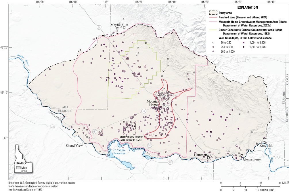
Location of study area in the Mountain Home area, southern Idaho. “Mountain Home plateau” and “Snake River canyon” are names of local origin and are presented herein in quotation marks.
Purpose and Scope
The purpose of this report is to describe a hydrogeologic framework for the Mountain Home area. The hydrogeologic framework includes four parts: (1) a conceptual description of the hydrogeologic units; (2) a three-dimensional hydrogeologic framework model and borehole database; (3) a map of groundwater levels and seasonal change; and (4) a discussion of groundwater occurrence and movement within the study area. This study compiled existing hydrologic and geologic data to define the hydrogeologic units and build the three-dimensional model and collected new groundwater-level data as well as analyzing existing data to generate the water table and describe groundwater occurrence and movement. Data from this study are available in Zinsser and others (2024).
The study area includes the City of Mountain Home and surrounding area of the western Snake River Plain that lies approximately between the boundaries of two existing numerical groundwater flow models (fig. 1) that are used by IDWR to help administer water rights: the Treasure Valley groundwater model (Hundt and Bartolino, 2023), and the Eastern Snake Plain Aquifer Model (Sukow, 2021). The study area encompasses the Mountain Home Groundwater Management Area and the Cinder Cone Butte Critical Groundwater Area and follows the boundary of IDWR Administrative Basin 61, with the addition of some area to the southwest in eastern Ada County which is not represented in the Treasure Valley groundwater model (fig. 1). While the boundary of Administrative Basin 61 (Idaho Department of Water Resources, 2022b) does not perfectly align with the polygon conventionally used to represent the Mountain Home Groundwater Management Area (fig. 1; Idaho Department of Water Resources, 2022a), it does align with the legal boundary defining the Mountain Home Groundwater Management Area (Idaho Department of Water Resources, 1982).
This hydrogeologic framework will provide IDWR with information to help administer water resources in the Mountain Home area and serves as the conceptual basis for developing a potential future numerical groundwater flow model.
Study Area
The study area lies in the western Snake River Plain, with the Snake River as the south boundary of the study area and the plateau north of the Snake River, hereinafter referred to as the “Mountain Home plateau,” representing most of the study area (fig. 1). The study area includes the communities of Hammett and King Hill and the City of Glenns Ferry, all in low-lying areas just north of the Snake River, hereinafter referred to as the “Snake River canyon”, as well as the City of Mountain Home and the Mountain Home Air Force Base, located on the “Mountain Home plateau”. Interstate Route 84 (I−84) roughly bisects the study area, running northwest to southeast. The Mount Bennett Hills form the uplands on the northeast study area boundary, east of U.S. Route 20, and the Danskin Mountains form the northwest boundary, west of U.S. Route 20 (fig. 1). Most of the study area lies in Elmore County although a part of the western study area is in Ada County.
The study area is largely rural with limited surface-water resources that are used primarily for irrigation (SPF Water Engineering LLC, 2017). Little Camas Reservoir, located north of the study area, supplies surface water to Long Tom and Mountain Home Reservoirs, and there are several other small reservoirs scattered across the “Mountain Home plateau.” Multiple streams begin in the uplands and discharge to the “Mountain Home plateau” and (or) the Snake River, including Canyon and Rattlesnake creeks in the west and Bennett, Cold Springs, Alkali, Little Canyon, and King Hill creeks in the east (fig. 1). Snake River water is used for irrigation of fields near the Snake River. Most of the landcover is sagebrush steppe (McGrath and others, 2002), with irrigated agriculture concentrated in the Cinder Cone Butte Critical Groundwater Area, south of the City of Mountain Home, and adjacent to the Snake River. Groundwater resources are used for irrigation, domestic, commercial, municipal, industrial, and stockwater uses (SPF Water Engineering LLC, 2017). Continued groundwater-level declines and limited surface-water resources have raised concerns that lack of water may stifle further economic development in Elmore County (SPF Water Engineering LLC, 2017) and require a new water supply to meet needs on the Mountain Home Air Force Base (SPF Water Engineering LLC, 2016).
Previous Work
Early hydrogeologic work in the Mountain Home area explored diverting surface water from the Boise River to the “forbidding, arid, sagebrush desert” (Nace and others, 1957, p. 3) of the “Mountain Home plateau” to increase agricultural production, stating that “To bring water to the plateau has been the hope of two generations of reclamationists, public servants, and local citizens” (Nace and others, 1957, p. 4). Nace and others (1957) characterized water-bearing units in the area, recognizing that groundwater in the “Mountain Home plateau” could only be obtained by deep wells in volcanic rock and sediments with moderate to low permeability. In 1962, the canonical geologic description of the intercalated basalts and sediments of the Snake River Group and the Idaho Group was published (Malde and Powers, 1962). Hydrogeologic investigations since that time have largely described hydrogeologic units in terms of these geologic groups and the formations therein. Mundorff and others (1964, p. 65) recognized that shallow water occurred in perched sand or gravel zones near the range front and that the regional aquifer occurred at depths greater than 200 feet (ft) in the “Snake River basalt and Idaho formation.”
The first extensive hydrogeologic investigation specific to the Mountain Home area was conducted by Ralston and Chapman (1968) and was motivated by the acceleration of groundwater resource development in the area. It described the occurrence of a perched groundwater zone around the City of Mountain Home and identified two formations of the Idaho Group as the main aquifer: (1) the Glenns Ferry Formation, comprising lake and stream sediments, in the eastern part of the study area, and (2) the Bruneau Formation, comprising basalt and sediments, in the western part of the study area (Ralston and Chapman, 1968). Young (1977) was the first to describe declining groundwater levels in the area now known as the Cinder Cone Butte Critical Groundwater Area. This study was also the first (and only) to explicitly spatially delineate the approximate area of the perched groundwater zone under the City of Mountain Home; the study also defined several additional perched groundwater zones along the Danskin Mountains range front and completed a synoptic groundwater-level survey in the fall of 1976 (Young, 1977). Finally, Young (1977) described water as occurring in virtually all geologic units found in the study area but identified the basalts of the Bruneau Formation as the most productive aquifer, with sands and gravels of the Idaho Group being the main aquifer in the eastern part of the study area.
Following the designation of the Cinder Cone Butte Critical Groundwater Area in 1981 (Idaho Department of Water Resources, 1981), Norton and others (1982) reviewed the hydrogeology of the area around the Cinder Cone Butte Critical Groundwater Area to evaluate if further administrative and management actions were necessary. The study (Norton and others, 1982) included a synoptic groundwater-level survey in fall of 1981, identified low-permeability along an apparent fault as a control on groundwater flow near I−84 in the Cinder Cone Butte Critical Groundwater Area, and largely agreed with the hydrogeologic interpretations of Young (1977).
A large body of work was completed by the USGS in the 1980s and early 1990s when the Snake River Plain regional aquifer system was investigated as part of a nationwide study of regional aquifer systems. This included a synoptic groundwater-level survey of the entire Snake River Plain regional aquifer done in spring of 1980 (Lindholm and others, 1988), the construction of a regional groundwater budget and numerical groundwater flow model for the western Snake River Plain (Newton, 1991), and the development of a geohydrologic framework for the entire Snake River Plain regional aquifer system (Whitehead, 1992).
More recently in the Mayfield area, researchers investigated aquifer recharge (Tesch and Vincent, 2009), recharge sources (Hopkins, 2013), detailed geology (Phillips and others, 2012), and described hydrogeologic conditions (Welhan, 2012; Tesch, 2013) in response to development pressure along the I−84 corridor and as part of the Comprehensive Aquifer Management Planning process initiated by the Idaho legislature (Idaho Legislature, 2008a, b). Tesch (2013) also described the continued decline of groundwater levels in the Cinder Cone Butte Critical Groundwater Area. Considering the ongoing declines in groundwater levels, the Idaho Water Resources Board obtained surface-water rights from the Snake River, evaluated this source as a potential new water supply to the Mountain Home Air Force Base (SPF Water Engineering LLC, 2016) and has recently advanced construction on a pipeline to deliver this water (Idaho Department of Water Resources, 2024c). Similarly, Elmore County commissioned a recent study to evaluate the sufficiency of water supplies for current and future uses, and to evaluate costs and options for developing new water supplies (SPF Water Engineering LLC, 2017).
Approach
The approach to generate this hydrogeologic framework comprised three parts. First, a literature review of pertinent existing hydrologic and geologic data was completed to describe the geologic history of the area as relevant to its hydrogeology. Second, existing well-driller reports were digitized to generate a borehole database, surficial geologic units were generalized into hydrogeologic units, and both were used to construct a three-dimensional hydrogeologic framework model. Third, groundwater-level measurements were taken in spring and autumn 2023 to generate water-table contour maps and other existing hydrologic data were compiled to describe long-term patterns in groundwater levels.
Borehole Data
The borehole database was compiled by digitizing existing borehole data. The primary source of data was the IDWR database of scanned well-driller reports (Idaho Department of Water Resources, 2024b) that include information on well construction and lithology, and an associated geographical information systems (GIS) file with well locations (Idaho Department of Water Resources, 2023). Minor additional data for deep exploration boreholes were compiled from the Idaho State Geological Survey oil and gas database (Idaho State Geological Survey, 2024), the U.S. Department of Energy Geothermal Data Repository (U.S. Department of Energy, 2024), and reports (Arney and others, 1984; Lewis and Stone, 1988). Boreholes were selected for entry into the database based on achieving good spatial distribution throughout the study area, availability of a drill log, having water-level data, and accuracy of location data. In addition, all wells measured during the 2023 groundwater-level synoptics were included in the borehole database even if they lacked an associated drill log. Location, lithology, groundwater level, and well-construction details were entered into the RockWorks20 (RockWare, 2023) database for 540 boreholes (Zinsser and others, 2024). Lithology is represented three ways in the database: the original well-driller description of lithology (for example, “brown clayey sand”), simplified primary (for example, “sand”) and secondary lithologies (for example, “clay”), and interpreted hydrogeologic framework unit or subunit (for example, “sand,” which is a subunit of the “coarse-grained sediments” hydrogeologic framework unit). In instances where the well-driller report indicates no returns or another uninterpretable lithology description (for example, “hard”), the primary lithology and hydrogeologic unit were assigned to “unknown.”
Three-Dimensional Hydrogeologic Framework Modeling
The three-dimensional hydrogeologic framework model was generated in RockWorks20 (RockWare, 2023) using the 540 boreholes in the database and the interpreted hydrogeologic framework units and subunits. An American Standard Code for Information Interchange (ASCII) grid file representing the model and video visualization are available in Zinsser and others (2024). The model voxel (grid cell) size was 100 meters (m) by 100 m horizontally by 25 ft vertically. Horizontal coordinates were represented in Idaho Transverse Mercator, which is a metric projection commonly used by agencies in the State of Idaho, whereas vertical distance was represented in feet to be consistent with well-driller reports. The model was built using the “highest probability” algorithm in the lithology solid model menu, with horizontal and vertical cutoff distances of 10 percent of the project area and closest-point declustering. The superface (upper model surface) was limited to the altitude of the land surface as defined by a grid derived from a 10-m digital elevation model of the study area (U.S. Geological Survey, 2022). The three-dimensional hydrogeologic framework model was clipped to the study area after it was generated.
Because the spatial distribution of the boreholes was uneven (fig. 2), the “add points” option was used in the lithology solid model menu to add regional surficial geologic data where there were no borehole data available. Specifically, units from the Idaho statewide geologic map (Lewis and others, 2012) were simplified and interpreted consistent with the hydrogeologic units and subunits (fig. 2). For example, Pleistocene and Pliocene basalt (unit Q T b of Lewis and others, 2012) and Pliocene and Miocene basalt (unit T p m b of Lewis and others, 2012) were combined into the “basalt” hydrogeologic framework unit. This surficial hydrogeologic framework unit map was used to create a grid of hydrogeologic unit points with 2,000 m by 2,000 m spacing in ArcGIS Pro (Esri, 2024), and each point was assigned an altitude, calculated as the surface altitude (based on the 10-m digital elevation model) minus 12.5 ft (half the depth of a model voxel). Grid points that were located within 2,500 m of a well were given a hydrogeologic framework unit value of NULL so that the model would preferentially use borehole lithology where available. Finally, the gridded hydrogeologic unit points were imported into RockWorks20 and used in the “add points” lithology solid model menu, along with the borehole data, to generate the three-dimensional hydrogeologic framework model. The spacing of the hydrogeologic unit points and NULL window were determined by trial and error to achieve maximum model coverage while still preferentially using borehole data where available.

Surficial expression of hydrogeologic framework units, regional faults, and hydrogeologic framework boreholes in the Mountain Home area, southern Idaho. Geology is simplified from Lewis and others (2012).”Snake River canyon” is a name of local origin and is presented herein in quotation marks.
Groundwater-Level Data
The USGS and IDWR measured groundwater levels in existing wells from March 20 to 24, 2023 (hereinafter referred to as spring 2023 synoptic) and November 1 to 7, 2023 (hereinafter referred to as autumn 2023 synoptic). Wells for the study were prioritized based on: (1) overall spatial coverage of the study area, (2) depth greater than 50 ft, and (3) drilled since the year 2000. Groundwater levels (depth to water) were measured in 180 domestic, irrigation, monitoring, and municipal wells. During the spring and autumn 2023 synoptics, IDWR measured groundwater levels in 38 wells and the USGS measured groundwater levels in 140 wells in accordance with USGS standard groundwater measurement procedures (Cunningham and Schalk, 2011). USGS data are published in the USGS National Water Information System (U.S. Geological Survey, 2024) and IDWR data are published in the Groundwater Data Portal (Idaho Department of Water Resources, 2024a). Wells were surveyed to the North American Datum of 1983 (NAD 83) and the North American Vertical Datum of 1988 (NAVD 88) by the agency which measured the groundwater level to establish accurate altitudes and locations. The altitude of the groundwater measuring point was surveyed using survey-grade Global Navigation Satellite System equipment and network following USGS standard methods described in Rydlund and Densmore (2012).
Additional groundwater-level data were measured by a consulting company in Elk Creek Village monitoring well (MW-1) and the Elk Creek Village production well (PW-1) (HDR, 2024) and used to fill a spatial gap in the water-table maps. Groundwater levels in these wells were measured every 6 hours by Solinst Levelogger pressure transducers and corrected using a Solinst Barologger for fluctuations in atmospheric pressure. Manual groundwater-level measurements were taken by the consulting company and were used to create a calibrated time series of groundwater levels. Groundwater levels for MW-1 and PW-1 were averaged over the timespan of the spring and autumn 2023 synoptics.
In addition to groundwater levels measured during the spring and autumn 2023 synoptics, IDWR maintains a network of groundwater-level monitoring wells across the “Mountain Home plateau” which have long-term records of manual measurements and continuous measurements collected by pressure transducers (Idaho Department of Water Resources, 2024a). These long-term data were used to generate hydrographs of the study area. Measurements collected when a well was pumping were removed from the dataset.
Water-Table Contours
A potentiometric surface is a representation of hydraulic head in a groundwater-flow system and is used to describe the direction of groundwater flow. The water table is the potentiometric surface that represents the hydraulic head of an unconfined aquifer. Hydraulic head can be described by determining the altitude of the groundwater level in a well. The aquifer in the study area is generally unconfined but may have locally confined conditions. The term “water table” in this report is used to describe the distribution of groundwater altitudes in the regional aquifer and the perched groundwater zone. Water-table contours were generated for the regional aquifer and the perched groundwater zone near the City of Mountain Home by interpolating groundwater altitudes among wells, creating contours from the interpolated surface, and manually modifying the contours based on interpretation of groundwater-flow direction. Different interpolation techniques were used for the regional (kriging) and perched groundwater zone (spline) because of differences in size of the aquifer and number of groundwater levels for each surface. ArcGIS Pro (Esri, 2024) was used for all interpolation. The wells used for contouring the regional and perched groundwater zone are available in Zinsser and others (2024).
Groundwater altitude was calculated by subtracting depth-to-water from land-surface altitude. Regional aquifer water-table contours were generated using cokriging with a spherical semivariogram to interpolate the groundwater altitude among wells (Uetrecht and others, 2019; Antonakos and Lambrakis, 2021). A 10-m digital elevation model was used as a secondary variable in the cokriging to better interpolate the steep hydraulic gradients in the foothills (U.S. Geological Survey, 2022). Data points with estimated altitudes were added beyond the study area southwest of Mayfield to avoid interpolated values in the west being influenced by groundwater levels in the Mayfield area, which would result in an unreasonable groundwater-flow direction. Cokriging parameters were optimized for autumn groundwater levels by minimizing the mean squared error and then used to interpolate spring groundwater levels. The same parameters were used for both the autumn and spring interpolation so resulting contour differences are from changes in groundwater levels and not differences in the interpolation. The parameters for cokriging are provided in table 1. Water-table contours were developed at 50-ft intervals using the cokriging output and modified manually based on interpretation of groundwater-flow direction. Water-table contours for the perched groundwater zone were generated using a thin plate spline interpolation instead of kriging because of the limited number of wells (Tayyab and others, 2023). Parameters for the spline interpolation are provided in table 1. Water-table contours were developed at 50-ft intervals using the spline output and smoothed using a 900-m tolerance.
Table 1.
Parameter values for cokriging, spline, and kriging used to interpolate the groundwater altitude and groundwater-level change among wells, Mountain Home area, southern Idaho.[ft2, square feet; --, none applicable; min, minimum; max, maximum]
Groundwater-Level Change
Groundwater-level change was calculated at each well from groundwater altitude between spring and autumn 2023; groundwater-level change data are available in Zinsser and others (2024). Groundwater levels declined when the altitude was lower in autumn compared to spring and rose when the altitude was higher in autumn compared to spring. A continuous groundwater-level change surface was generated using simple kriging to interpolate groundwater-level change among wells (Ahmadi and Sedghamiz, 2007; Júnez-Ferreira and others, 2023; Ramage and Braun, 2023). Parameters for kriging are provided in table 1. A small kriging range (3,500 m) was used to minimize interpolating groundwater-level change where wells were sparse and to avoid extending groundwater-level rise from the “Snake River canyon” to upgradient areas on the “Mountain Home plateau.” Groundwater-level change was assumed to be 0 ft where there were no data (McGuire, 2013). Therefore, the mean value of the dataset was set to 0 ft of change to allow the tendency of the groundwater-level change interpolation to approach 0 ft. Groundwater-level change was extrapolated beyond wells in the western and eastern parts of the study area. Additional data points with 0 ft of groundwater-level change were added on the “Mountain Home plateau” above the City of Grand View to constrain groundwater-level rise to the “Snake River canyon”, consistent with groundwater-level measurements.
Groundwater storage change between spring and autumn 2023 synoptics was estimated using the groundwater-level change surface and storativity estimates of the hydrogeologic units (table 2). The storativity of each hydrogeologic unit that was intercepted by the autumn 2023 water table was used because the change in storage is assumed to be occurring within that hydrogeologic unit. Because storage change is sensitive to the storativity value used, storage change was also calculated using a uniform storativity of 0.1, which is consistent with the value previously used by Newton (1991) for the study area. The change in groundwater storage was calculated using equation 1, and is defined as:
where∆ groundwater storage
is the change in groundwater storage from spring 2023 to autumn 2023 in acre-feet (acre-ft);
∆ groundwater level
is the change in groundwater level from spring 2023 to autumn 2023 in feet;
storativity
is the storativity of hydrogeologic unit in which the groundwater-level change occurred, dimensionless; and
area
is the area in acres.
Table 2.
Published ranges of transmissivity and storativity in hydrogeologic units in the Mountain Home area, southern Idaho.[Storativity from Woessner and Poeter (2020). Best estimate, most representative value based on available data. Shading present for visual grouping. lower, minimum estimate; upper, maximum estimate; --, no value]
| Hydrogeologic unit | Lithology | Transmissivity (foot squared per day) | Reference | Storativity, best estimate (dimensionless) | Storativity, lower (dimensionless) | Storativity, upper (dimensionless) |
|---|---|---|---|---|---|---|
| Fine-grained sediments | Silt | 970–3,325 | SPF Water Engineering LLC (2007) | 0.15 | 0.01 | 0.4 |
| Clay | -- | -- | -- | |||
| Siltstone | -- | -- | -- | |||
| Shale | -- | -- | -- | |||
| Coarse-grained sediments | Sand | 5,000–230,000 | Nace and others (1957) | 0.25 | 0.1 | 0.46 |
| Gravel | 0.25 | 0.13 | 0.4 | |||
| Sandstone | 500–2,800 | Chapman and Ralston (1970) | -- | -- | -- | |
| Basalt | Interflow zones and near-vent deposits, including cinders | 48,200 | Young (1977) | 0.2 | 0.02 | 0.47 |
| Thick and thin massive flows | 20 | Mann (1986) | 0.1 | 0.02 | 0.15 | |
| Void | -- | -- | 0.1 | 0.02 | 0.15 | |
| Rhyolite | Igneous, fine-grained rock | -- | -- | 0.03 | 0.001 | 0.05 |
| Granite | Igneous, coarse-grained rock | -- | -- | 0.03 | 0.001 | 0.05 |
The groundwater storage change was calculated for the Cinder Cone Butte Critical Groundwater Area, the Mountain Home Groundwater Management Area, the combined groundwater management areas, the part of the study area not within the two groundwater management areas, and the perched groundwater zone. Continuous surfaces representing feet of change (groundwater storage volume per area) in groundwater storage between spring and autumn 2023 for the regional aquifer and perched groundwater zone are available in Zinsser and others (2024).
Hydrogeologic Framework
This hydrogeologic framework describes the geologic history of the “Mountain Home plateau” and surrounding area, defines hydrogeologic units based on this history, and describes the occurrence and movement of groundwater within those units. Collectively, the hydrogeologic framework represents a conceptual model of the geologic controls on groundwater within the study area.
Geologic History
The geology of the western Snake River Plain is complex, reflecting intersecting forces of tectonics, shifting depositional and erosive environments, and multiple eras of volcanism. In general, the western Snake River Plain is a northwest-trending extensional basin bounded by northwest-trending faults (Lewis and others, 2012). The Cretaceous granitic rocks of the Idaho batholith form the uplands north of the central plain and occur in minor amounts south of the plain; the uplands northeast and south of the plain are composed of Tertiary rhyolite and basalt (Lewis and others, 2012). The basin is filled with Tertiary and Quaternary sediments of lacustrine, fluvial, and alluvial origin, underlain by and interlayered complexly with Tertiary and Quaternary basalts (Lewis and others, 2012).
Idavada Volcanics, Faulting, and the Formation of Lake Idaho
The oldest volcanic rocks present in the study area (ca. 12–10 million years ago [Ma] (Wood and Clemens, 2002)) are the rhyolites and basalts of the Idavada Volcanics (Malde and Powers, 1962) that outcrop in the eastern Danskin Mountains and the Mount Bennett Hills and are associated with the southwest migration of the continental plate over the Yellowstone hot spot (Pierce and Morgan, 1992). The western Snake River Plain formed as an intercontinental rift basin with normal faulting in the Mount Bennett Hills representing 2.8 kilometers (km) of offset and occurring from 11 to 9.5 Ma (Wood and Clemens, 2002). Geophysical and deep borehole data suggest that mafic intrusive rocks, consistent with rifting, underlie the central axis of the plain near Mountain Home (Mabey, 1982; Wood and Clemens, 2002) although basaltic tuff, interpreted as Idavada Volcanics, was intercepted below 7,150 ft at the far eastern end of the plain (Arney and others, 1984; Clemens and Wood, 1993; Shervais and others, 2002). Rhyolites altered by interaction with water (Jenks and Bonnichsen, 1989) suggest that the formation of paleo Lake Idaho, a large, deep lake in the western Snake River Plain, preceded the rhyolitic volcanism and faulting (Wood and Clemens, 2002), potentially forming as early as 12 Ma (Bonnichsen and others, 2016). Lake Idaho is indicated by the occurrence of thick fluvial and lacustrine sediments, interbedded with spatially discrete basalt units in varying proportions, that make up the conventional Idaho Group and extend over 100 miles along the Snake River (Malde and Powers, 1962). The Chalk Hills Formation of the Idaho Group represents the first phase of deep Lake Idaho, dated between approximately 10–6 Ma (Wood and Clemens, 2002); maximum lake level is thought to be from 1,100 to 1,160 m (3,610 to 3,800 ft) based on preserved shoreline features (Jenks and Bonnichsen, 1989; Bonnichsen and others, 2016).
Miocene Basalts and Lake Idaho
Basalts interbedded with sediments represent a period of volcanism occurring from 9 to 7 Ma (White and others, 2002); this volcanism occurred under varied subaerial and sublacustrine conditions, with basalt flow pathways likely influenced by Lake Idaho and in turn influencing deposition of sediment associated with Lake Idaho (Jenks and Bonnichsen, 1989). In the Mountain Home area, these basalts alternately have been described as pre-Lake Idaho (Shervais and others, 2002) or as subaqueously deposited water-affected basalts (Godchaux and Bonnichsen, 2002) and have been intercepted below sediments in multiple deep boreholes (Shervais and others, 2002). Conventionally, this unit was defined as the Banbury Basalt of Idaho Group (Malde and Powers, 1962) but multiple later researchers have ceased to use this term because its widespread assignment and correlation outside the type section rendered it unuseful (Bonnichsen and Jenks, 1990; Wood and Clemens, 2002); researchers now favor naming only contiguous basalt units (Jenks and others, 1998; Shervais and others, 2002; Wood and Clemens, 2002). During a break in volcanic activity from approximately 7 to 2.2 Ma (White and others, 2002), the level of Lake Idaho likely fluctuated, including a substantial drawdown around 6 Ma (Wood and Clemens, 2002). The second phase of deep Lake Idaho is associated with the Glenns Ferry Formation, dated from approximately 4.3 to 2.5 Ma (Wood and Clemens, 2002). The Glenns Ferry Formation includes deep lacustrine facies as well as mixed fluvial and floodplain facies at the margin of the lake (Malde, 1972) and prograding delta deposits representing lake drawdown (Wood and Clemens, 2002). The Glenns Ferry Formation crops out at the surface at the eastern end of the study area and has been interpreted as occurring at depth in deep boreholes in the central part of the study area (Arney and others, 1984). The repeated fill and drawdown of Lake Idaho may be related to the reorganization of the Snake River drainage, which was driven by eastward migration of the continental divide due to thermal doming associated with continental passage over the Yellowstone hot spot (Pierce and Morgan, 1992; Wood and Clemens, 2002; Staisch and others, 2021).
Pleistocene Basalts and Surficial Sediments
Basaltic volcanism reinitiated at about 2 Ma (White and others, 2002), about the same time as Lake Idaho began to drawdown for the final time (Wood and Clemens, 2002). These eruptions formed relatively thin, laterally extensive, coalescing flows on top of Lake Idaho sediments or older basalts and created the topographic plateau of the Mountain Home area, flowing into Lake Idaho in some places (Shervais and others, 2002; Wood and Clemens, 2002). These plateau-forming basalts are analogous to the Bruneau Formation (Malde and Powers, 1962). Many styles of basaltic volcanism occurred during the Pleistocene, including maar and cinder cone styles that indicate subaerial eruption in swampy, recently drained, or groundwater-intercepting conditions (Godchaux and Bonnichsen, 2002). Depending on their age, these basalts may have erupted along the shores of Lake Idaho or through streams or groundwater after the final draining of Lake Idaho (Godchaux and Bonnichsen, 2002). Finally, unconsolidated surficial sediments, including alluvial fans, melon gravels associated with the Bonneville flood, landslide deposits, and alluvium were deposited on the surface of the study area (Lewis and others, 2012).
Hydrogeologic Units
Hydrogeologic units describe units or types of sediments or rocks that have distinct hydraulic properties which influence the storage and movement of groundwater (Isensee and others, 1989). Previous researchers (Ralston and Chapman, 1968; Young, 1977; Norton and others, 1982; Whitehead, 1986, 1992; SPF Water Engineering LLC, 2017) have largely defined the hydrogeologic units in the Mountain Home area in relation to the stratigraphic units defined by Malde and Powers (1962), although some have taken a more generalized approach (Newton, 1991; Welhan, 2012). As described in the “Geologic History” section, researchers no longer use some of the basalt stratigraphic units of Malde and Powers (1962) outside of their type sections, recognizing that correlations over long distances are likely spurious (Bonnichsen and Jenks, 1990; Shervais and others, 2002; Wood and Clemens, 2002). Furthermore, in most well-driller reports, lithology descriptions cannot be readily resolved to stratigraphy. Thus, hydrogeologic units and subunits are defined here in terms of primary lithology, which is consistent with the approach of recent hydrogeologic analyses in the Treasure Valley (Bartolino, 2019) and the Mayfield area (Welhan, 2012).
Granite
Cretaceous granitic rocks, primarily granodiorite and two-mica granite (unit K g) of Lewis and others (2012), crop out at the surface in the western Danskin Mountains (fig. 2). Also grouped in this hydrogeologic unit (fig. 3) are very minor amounts of Cambrian to Neoproterozoic Windermere Supergroup metamorphic rocks (unit _ Z s of Lewis and others, 2012) and Neoproterozoic granitic gneiss (unit Z i of Lewis and others, 2012), both exposed in the House Mountain metamorphic complex at the far northern study boundary. Similarly, a minor amount of silicic Challis intrusive rocks (unit T e i of Lewis and others [2012]) are exposed at the far northeastern study boundary. Functionally, all of these crystalline rocks have low storativity and hydraulic conductivity, with secondary permeability associated with jointing and fracturing (tables 2, 3) and are thus reasonably combined into the granite hydrogeologic unit.

Relation of geologic and hydrogeologic units of the Mountain Home area, southern Idaho.
Table 3.
Published ranges of hydraulic conductivity of hydrogeologic units in the Mountain Home area, southern Idaho.[Shading present for visual grouping]
| Hydrogeologic unit | Lithology | Range of hydraulic conductivity (feet per day) | Reference |
|---|---|---|---|
| Fine-grained sediments | Silt | 2.6×10⁻⁵ to 2.0×100 | Spitz and Moreno (1996) |
| Clay | 1.3×10⁻⁴ to 1.3×10⁻¹ | Spitz and Moreno (1996) | |
| Siltstone | 2.8×10⁻⁶ to 4.0×10⁻³ | Spitz and Moreno (1996) | |
| Shale | 3.3×10⁻⁸ to 7.4×100 | Spitz and Moreno (1996) | |
| Coarse-grained sediments | Sand | 1.4×100 to 2.8×10³ | Spitz and Moreno (1996) |
| Gravel | 1.4×10² to 2.8×10⁵ | Spitz and Moreno (1996) | |
| Sandstone | 9.4×10⁻⁴ to 1.53×101 | Spitz and Moreno (1996) | |
| Basalt | Interflow zones and near-vent deposits, including cinders | 1.0×10² to 3.2×10⁴ | Anderson and others (1999) |
| Thick and thin massive flows | 1.0×10⁻² to 1.0×10² | Anderson and others (1999) | |
| Void1 | 3.3×10² to 2.3×10⁴ | Spitz and Moreno (1996) | |
| Rhyolite | Igneous, fine-grained rock | 1.73×10⁻¹ to 3.86×10² | Spitz and Moreno (1996) |
| Granite | Igneous, coarse-grained rock | 1.19×10⁻³ to 1.19×101 | Spitz and Moreno (1996) |
Rhyolite
Rhyolite crops out extensively at the surface in the eastern Danskin Mountains and in the Mount Bennett Hills (fig. 2); it was defined at the surface from the Miocene rhyolite unit ( T m r) of Lewis and others (2012; fig. 3). This unit occurs in the subsurface occasionally in boreholes that were drilled within or just south of the rhyolite units that were mapped at the surface. Permeability in this unit is secondary, associated with jointing and fracturing (Ralston and Chapman, 1968; Whitehead, 1992) and the unit has low storativity and hydraulic conductivity (tables 2, 3).
Basalt
As discussed in the “Geologic History” section, there are likely basalts of at least two ages in the study area—Miocene and Pliocene basalt (unit T p m b of Lewis and others, 2012) and the younger Pliocene and Pleistocene basalt (unit Q T b of Lewis and others, 2012; fig. 3). These units occur extensively at the surface and in the subsurface through the central and southern parts of the study area and to a lesser extent in the eastern study area (fig. 2). The basalt hydrogeologic unit includes the following subunits: basalt (undifferentiated), cinders, and voids as interpreted from the well-driller reports. This detailed lithology is retained in part because there is likely to be significant heterogeneity within and between basalt units. In the eastern Snake River Plain, basalts are recognized to have low permeability in massive basalts as well as high permeability zones in the porous, broken interflow zone between lava flows, through networks of interconnected open fissures (voids), and in scoria (cinders) near vents (Anderson and others, 1999; Welhan and others, 2002; Ackerman and others, 2006). Therefore, the hydraulic properties of a given basalt unit are highly dependent on its characteristics and likely to be highly spatially heterogeneous, representing a range of storativity values and hydraulic conductivities from low to high (tables 2, 3). Transmissivity of this unit was estimated to be 48,200 feet squared per day (ft2/d) in the study area (Young, 1977), but could be as low as 20 ft2/d (Mann, 1986; table 2).
Fine-Grained Sediments
Fine-grained sediments were defined at the surface of the study area (fig. 2) based on map units of Lewis and others (2012): Q s (fluvial and lake sediment) and Q T p m s (sedimentary rocks, including consolidated to weakly consolidated sandstone and siltstone deposits of Lake Idaho; fig. 3). The fine-grained sediments unit occurs at the surface in the southeastern part of the study area, along the Snake River in the south, and near the foothills in the northwest (fig. 2); it also occurs at depths greater than 500 ft in deep boreholes on the Mountain Home Air Force Base (Deep-MH-1, Lewis and Stone [1988] and Deep-MH-2, Shervais and others [2012]). The northern extent of this unit is unclear since much of the study area is covered in basalt. However, assuming a high lake level from 1,100 to 1,160 m (3,610 to 3,800 ft) and minimal subsequent tectonic alteration (Jenks and Bonnichsen, 1989), Lake Idaho may have extended nearly to the foothills of the Danskin Mountains and Mount Bennett Hills, an altitude of approximately 1,200 m or 3,940 ft (Phillips and others, 2012).
The Lake Idaho deposits posed a substantial challenge for defining hydrogeologic units; these deposits are described in part as containing clastic beds that “are consolidated, although usually not lithified” (Malde and Powers, 1962, p. 1,202). In well-driller reports, presumed Lake Idaho deposits are variably described. For example, in an area with mapped Lake Idaho deposits and within a short horizontal distance, one well-driller report described shale and sandstone (for example, 352841; Zinsser and others, 2024), whereas a nearby well-driller report described clay and sand (for example, 307071; Zinsser and others, 2024). Because of this discrepancy in driller interpretation of rock versus sediment, the fine-grained unit includes the following primary lithologies as interpreted from the well-driller reports: silt, clay, shale, siltstone, sedimentary rock, and hardpan/caliche. Although lumping these units substantially improves lithologic continuity in the hydrogeologic framework model and is similar to the approach taken in the nearby Treasure Valley (Bartolino, 2019), it is likely that the hydraulic properties of these materials differ substantially. In general, hydraulic properties of the fine-grained sediments unit are intermediate (tables 2, 3). Transmissivity of this unit ranges from 970 to 3,325 ft2/d (table 2).
Coarse-Grained Sediments
Coarse-grained sediments were defined at the surface of the study area (fig. 2) based on the map units of Lewis and others (2012): Q a (alluvial deposits), Q l s (landslide deposits), Q a f (alluvial fan deposits), Q b s (Bonneville flood deposits), and Q T s (sediments and sedimentary rocks, including old terrace gravels; fig. 3). This unit occurs at the surface primarily along the range front, in tongues tracing the location of streams across the “Mountain Home plateau”, and along the “Snake River canyon” (fig. 2). Coarse-grained sediments also occur extensively at all depths interbedded with basalts and fine-grained sediments. Although grain size is poorly sorted in many of these deposits, coarser grain sizes (sand, gravel) are the defining feature of this unit. Similar to the fine-grained unit, the coarse-grained unit includes multiple primary lithologies interpreted from the well-driller reports: sand, gravel, sandstone, conglomerate, and boulders. The hydraulic properties of these materials likely differ spatially but are generally high (tables 2, 3). Transmissivity of the unit may range from 500 to 230,000 ft2/d (table 2).
Three-Dimensional Hydrogeologic Framework Model and Database
Model and Database
The surface geology of the three-dimensional hydrogeologic framework model reasonably represents the surface location of the hydrogeologic units (figs. 2, 4) as defined by simplified geology from (Lewis and others, 2012). The model contains more variation at the surface than the simplified geology because the model was constrained by borehole lithology which describe units at a finer scale than the simplified geology and thus provides the model with more detail in areas with high borehole density (for example, in the central study area). The surficial expression of the hydrogeologic units in the model was improved in areas with low borehole density (for example, in the Danskin Mountains, Mount Bennett Hills, and southeastern “Mountain Home plateau”) by incorporating the surficial hydrogeologic unit locations as additional data points.

Surficial expression of the three-dimensional hydrogeologic framework model and cross-section and fence diagram traces in the Mountain Home area, southern Idaho (Zinsser and others, 2024). See figure 5 for fence diagram identified in this figure. See figures 6–9 for cross sections identified in this figure.
At depth, the three-dimensional hydrogeologic framework model reasonably represents expected geology throughout the study area (fig. 5) except below the mountain front, where the model incorrectly extrapolates fine-grained sediments extending under granite bedrock. In general, fine-grained sediments interlayered with minor coarse-grained sediments underlie most of the study area, thickening to the southeast (fig. 6). In the central and eastern parts of the study area, this unit also thickens toward the south (figs. 7, 8). Basalt, with minor and generally spatially discrete cinder units and minor interlayered fine- and coarse-grained sediments, predominates in the central study area (underlying the City of Mountain Home; fig. 8) and in the southwestern study area (although there is limited borehole data in this area; fig. 5). The coarse-grained sediments unit occurs in substantiative amounts on the Danskin Mountain range front (fig. 9) and in the Hammett area (fig. 7). Granite and rhyolite occur in the Danskin Mountains, from west to east, respectively, although the model inaccurately depicts these units as underlain by fine-grained sediments and basalt because of a lack of borehole data in the mountains (figs. 5, 9). Rhyolite also occurs in the model at depth below the Mount Bennett Hills range front (fig. 7), which is generally accurate, but the model-depicted interlayering of fine-grained sediments and rhyolite is unlikely.
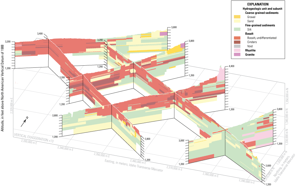
Perspective view of fence diagram of the three-dimensional hydrogeologic framework model, Mountain Home area, southern Idaho. View is from the southeast looking to the northwest (bearing 165 degrees) from an elevation of 30 degrees above the horizon. Traces of cross sections are shown on figure 4 (Zinsser and others, 2024).
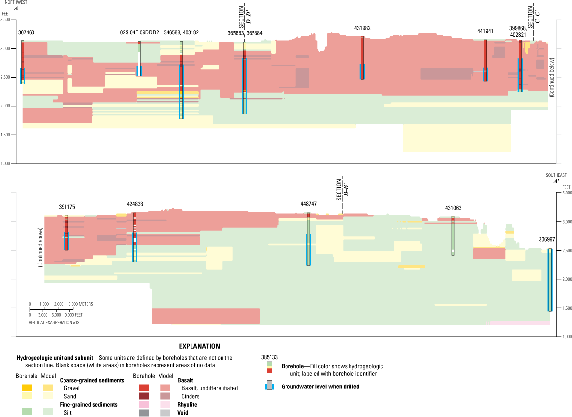
Geologic long section (A–A′) of the three-dimensional hydrogeologic framework model, from northwest to southeast, Mountain Home area, southern Idaho. Location of long section is shown in figure 4 (Zinsser and others, 2024).
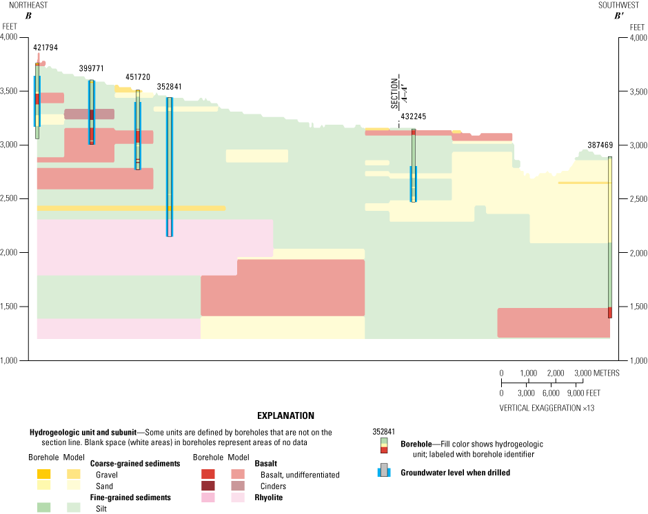
Geologic cross section (B–B′) of the three-dimensional hydrogeologic framework model from northeast to southwest, east of the City of Mountain Home, southern Idaho. Location of cross section is shown in figure 4 (Zinsser and others, 2024).

Geologic cross section (C–C′) of the three-dimensional hydrogeologic framework model from north to south, near the City of Mountain Home, southern Idaho. Location of cross section is shown in figure 4 (Zinsser and others, 2024).
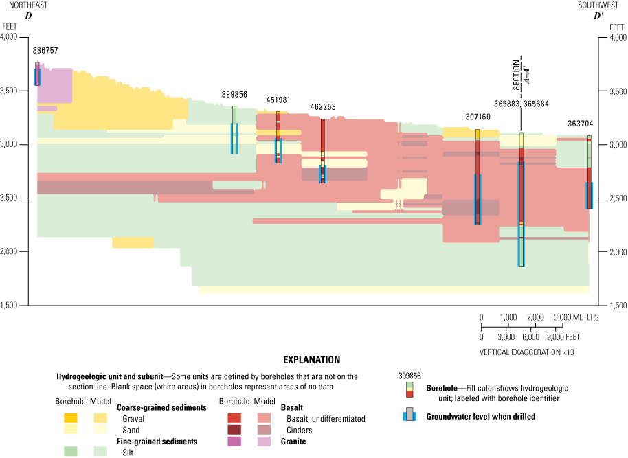
Geologic cross section (D–D′) of the three-dimensional hydrogeologic framework model from northeast to southwest, west of the City of Mountain Home. Location of cross section is shown in figure 4 (Zinsser and others, 2024).
Volumetrically (table 4), the largest hydrogeologic unit in the three-dimensional hydrogeologic framework model is fine-grained sediments (37 percent), followed by basalt (about 32 percent), coarse-grained sediments (about 19 percent), rhyolite (9.5 percent), and granite (2.2 percent). The volumetric percentages of rhyolite and granite are almost certainly an underestimate because the model does a poor job of representing these units at depth in the Danskin Mountains and Mount Bennett Hills because of a lack of deep boreholes in the mountains. Overall, basalt (about 49 percent) was the most common lithology by length in the borehole database (table 4), followed by fine-grained sediments (24 percent) and coarse-grained sediments (about 13 percent).
Table 4.
Hydrogeologic unit volumes in the three-dimensional hydrogeologic framework model and borehole database, Mountain Home area, southern Idaho.[Data in table are summarized from Zinsser and others, 2024. Percentages may not add to 100 because of rounding. Shading present for visual grouping. --, not assigned]
Limitations
There are inherent limitations in the borehole database and three-dimensional hydrogeologic framework model. The quality of borehole location data varies; boreholes with more certainty in their locations (for example, locations were determined by a global positioning system) were preferentially selected whenever possible, but some borehole locations are only known to the center of the nearest quarter-quarter section (as in, within 285 m [Lifton and others, 2021], assuming the quarter-quarter section was correctly identified). The quality of lithology and construction information also varies between well-driller reports, and the hydrogeologic units and subunits were drastically simplified from lithology to generate the model. Longer boreholes were preferentially selected over shorter boreholes, when possible, to get better lithology coverage, and database groundwater levels represent static water levels as reported when the wells were drilled, which encompasses more than 50 years. There is evidence that faulting both impedes and enhances groundwater flow (see section, “Faulting and Geothermal”) within the study area, but faults are not explicitly represented within the hydrogeologic framework model.
The choice of modeling algorithm and parameters also fundamentally limits the model; in this case, somewhat generous search distances allowed lithology to be interpreted for the full model, thereby preventing geologic gaps at the expense of poor interpretations in other areas (for example, the projection of sediment units under granite in the mountains). Unit transitions are also modeled abruptly, which allows the model to be repeatable, but unit transitions are therefore not geologically realistic in many situations. Model interpretations should be considered with caution in areas with sparse data (for example, under the mountains, the southwestern study area, and depths greater than 1,000 ft). The three-dimensional hydrogeologic framework model has the most complexity and is likely most representative of actual conditions within 1,000 ft of the surface and in areas with good borehole coverage.
Groundwater Occurrence, Movement, and Change
Groundwater Occurrence
The borehole database is a helpful but imperfect tool to describe groundwater occurrence. For example, the quality of information varies in the well-driller reports, construction information is often incomplete, and boreholes are frequently open to multiple formations. Completion depth and lithology may not coincide with the water-bearing unit, and not all boreholes intercepted water or were intended for water production. For example, several very deep boreholes were drilled for oil and gas or deep geothermal exploration, and several others were drilled for gas pipeline cathode protection. Deep boreholes were also preferentially selected over shallow boreholes to get more complete lithology information, which may bias summary borehole statistics. Nonetheless, the 540 boreholes described in the database represent a rich data source to describe general patterns in water occurrence and are used here as such.
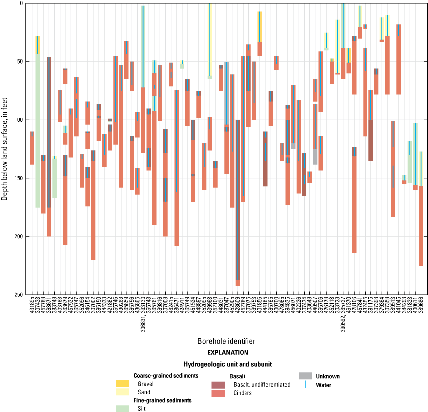
Based on reported water-bearing intervals and well completion lithologies in the borehole database, each hydrogeologic unit is capable of producing water. Wells are most commonly completed, in order, in basalt (undifferentiated subunit), fine-grained sediments (silt), unknown, coarse-grained sediments (sand subunit), and in the cinders subunit of the basalt hydrogeologic unit (fig. 10). Proportionally, water-bearing units occur most often in the cinders subunit (fig. 10). The median borehole depth was 491 ft, and over 95 percent of the boreholes are less than 1,000 ft. The total depth of wells tends to be shallowest (less than 250 ft) proximal to the range front and in lowlands adjacent to the Snake River (fig. 11). The deepest wells (greater than 1,000 ft) mostly occur in the Cinder Cone Butte Critical Groundwater Area and in the eastern study area (fig. 11).
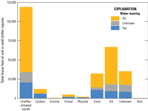
Association and frequency of water-bearing zones in the hydrogeologic units and subunits, Mountain Home area, southern Idaho (Zinsser and others, 2024).
Completion depth for boreholes in the borehole database, Mountain Home area, southern Idaho (Zinsser and others, 2024).
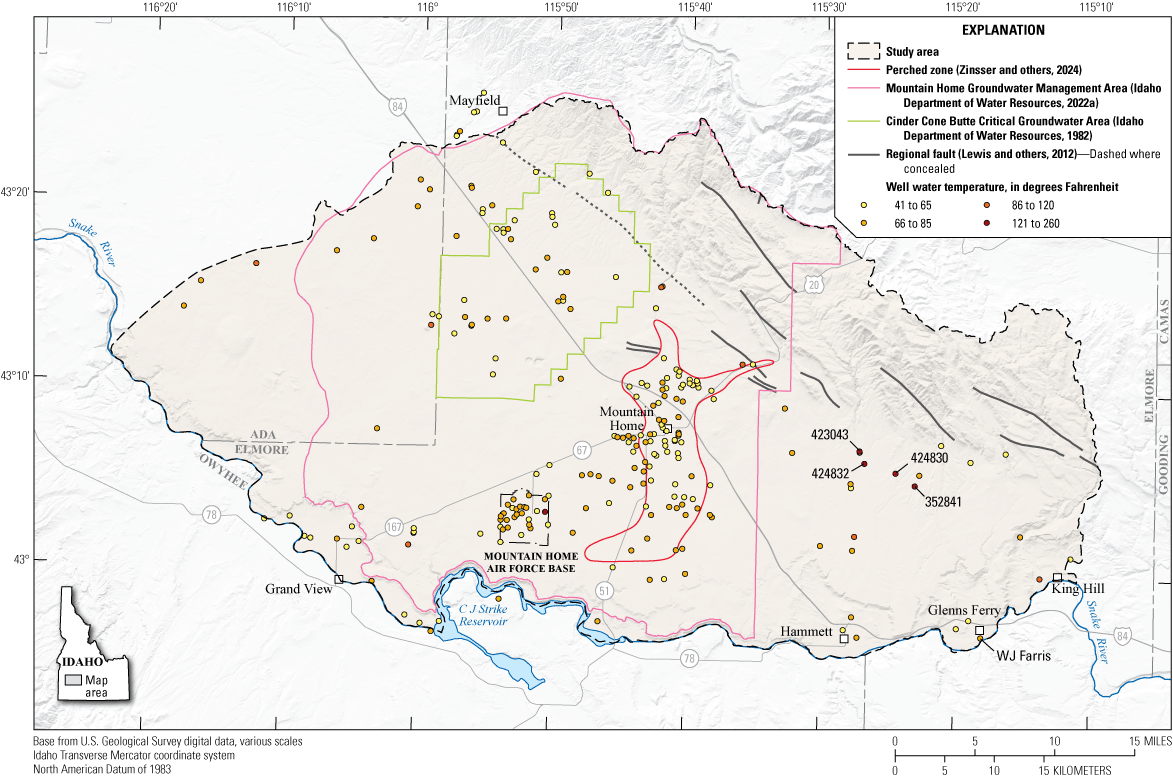
Historically, both artesian and geothermal groundwater conditions have been observed in the study area (Ralston and Chapman, 1968). Although not all well-driller reports include water temperature at completion, water temperature was indicated in 235 of 540 reports; of these, 13 were recorded as greater than 85 degrees Fahrenheit. Most of the geothermal wells are located along the range front in a strikingly subparallel arrangement to northwest-trending faults, although several geothermal wells also occur along the central axis of the study area (fig. 12). Non-geothermal artesian conditions also occur in at least one well in the City of Glenns Ferry (308657; Zinsser and others, 2024) and were historically reported in the vicinity of the geothermal artesian wells in the Mount Bennett Hills range front (Ralston and Chapman, 1968).
Water temperature for wells in the borehole database, Mountain Home area, southern Idaho (Zinsser and others, 2024).
Groundwater Altitude and Flow Direction
Two water-table contour maps were developed for the study area: one for the regional aquifer from the foothills in the north to the Snake River in the south (fig. 13A), and the other for the perched groundwater zone near the City of Mountain Home (fig. 13B). The regional water-table contour map was developed using groundwater altitudes from 139 wells. Depth to water in wells in the regional aquifer ranges from 150 to 765 ft. Previous studies have identified multiple perched groundwater zones near the City of Mountain Home (Young and others, 1992). The perched groundwater zone water-table contour map for this report represents a generalized water table from groundwater altitudes measured in 24 wells. Depth to water in wells in the perched groundwater zone ranges from 30 to 100 ft. However, 7 additional wells measured in the perched zone area had groundwater altitudes inconsistent (higher and lower) with nearby wells and may represent either multiple perched zones or are open to both the perched groundwater zone and the regional aquifer with groundwater levels influenced by both (fig. 13A, B; wells in unknown zone). The water table presented therefore represents one out of many possible interpretations of variable groundwater levels. Four wells were determined to represent perched groundwater conditions in the Mayfield area and were not included in contouring. Additional perched groundwater zones occur below the Mountain Home Air Force Base and in the Cinder Cone Butte Critical Groundwater Area but are not a significant source of supply and were not included in the water-table maps (SPF Water Engineering LLC, 2017; Air Force Civil Engineer Center, 2022). In four wells outside of the perched groundwater zone, groundwater levels indicated that conditions in the wells were not representative of the regional aquifer; thus, the four wells were not included in the regional contouring (fig. 13B; wells in unknown zone). Two wells were not included in contouring because the wells were being pumped or had been recently pumped at the time of measurement.
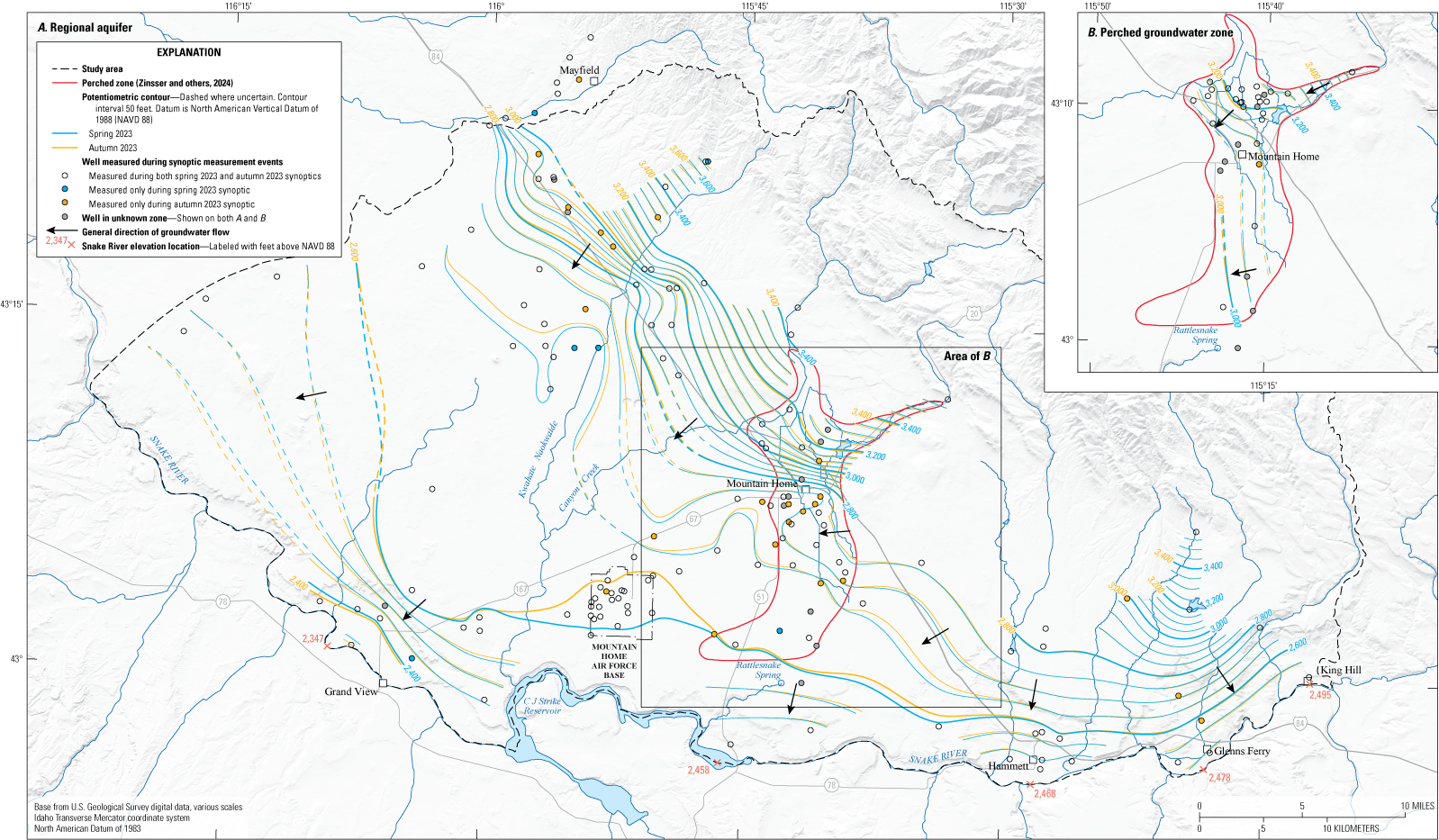
Water-table contours in March and November 2023 for (A), the regional aquifer and (B), the perched groundwater zone, Mountain Home area, southern Idaho (Idaho Department of Water Resources, 2024a; U.S. Geological Survey, 2024; Zinsser and others, 2024).
Regional groundwater generally flows from the foothills in the north of the study area toward the Snake River in the south-southwest (fig. 13A). Depth to water in wells in the regional aquifer ranges from 150 to 765 ft. The hydraulic gradient is steep in the north (100 feet per mile [ft/mi]), flattens south of the City of Mountain Home and Cinder Cone Butte Critical Groundwater Area (10 ft/mi), then steepens again at the “Snake River canyon” (50 ft/mi). Groundwater discharge is thought to be to the Snake River based on concurrence between the projected water table and Snake River surface-water altitudes (fig. 13A). This interpretation is consistent with previous researchers (Nace and others, 1957; Ralston and Chapman, 1968), a numerical groundwater flow model (Newton, 1991), and estimated groundwater discharge to the Snake River in this reach (Wood and others, 2014).
Generally, the spring and autumn water-table contours are consistent. The water-table contours moved upgradient in areas that experienced groundwater-level declines between the spring and autumn 2023 synoptics, but the direction of flow was consistent (fig. 13A). Water-table contours are uncertain in the southwestern study area and between the Cinder Cone Butte Critical Groundwater Area and the City of Mountain Home because of a lack of wells in those areas (fig. 13A). Low hydraulic gradients south of the City of Mountain Home and the Cinder Cone Butte Critical Groundwater Area could be related to long-term groundwater-level declines (Tesch, 2013) or could be due to higher transmissivity of the aquifer in these areas (Lindholm and others, 1988). The regional water-table contours from 2023 are generally consistent with groundwater flow described in previous reports although groundwater altitudes are lower in the Cinder Cone Butte Critical Groundwater Area and south of the City of Mountain Home than previously reported (Young, 1977; Young and others, 1992).
The general groundwater flow direction of the perched groundwater zone north of I−84 is to the southwest, whereas south of I−84 the flow direction is more westerly (fig. 13B). The groundwater level in the perched groundwater zone north of I−84 is approximately 50 ft above the regional aquifer. The perched groundwater zone and regional aquifer become closer in depth south of I−84 on the western extent of the perched groundwater zone which may be an indication of downward infiltration of perched groundwater into the regional aquifer. Because of the closeness in depth of the perched groundwater zone and regional aquifers on the western extent, it is possible to make multiple valid interpretations of the water-table contours. In the southern extent of the perched groundwater zone, the regional aquifer deepens and the perched groundwater zone shallows, resulting in greater depth between the two. As groundwater flows southwesterly toward the edge of the perched groundwater zone, the groundwater percolates downward to the regional aquifer through preferential pathways (Young, 1977; Bendixsen, 1994). The perched groundwater zone may also discharge at Rattlesnake Spring (Norton and others, 1982; Bendixsen, 1994). However, the water table shows flow to the west, implying only localized perched groundwater discharges at Rattlesnake Spring and most groundwater percolates through the unsaturated zone to the regional aquifer on the western boundary of the perched groundwater zone (fig. 13B).
Information about vertical hydraulic gradients in the study area is limited as there are limited monitoring wells open to different depths (rather than open to all depths). A consulting company measured groundwater levels in a dedicated groundwater-level monitoring well screened from 418 to 540 ft below land surface and an adjacent, deep 1,120-ft production well screened from 890 to 1,090 ft below land surface. Groundwater level is higher in the deep production well than the shallower monitoring well, suggesting there is an upward hydraulic gradient (HDR, 2024). However, it is unclear if there is truly upward flow or if this reflects the occurrence of a locally confining layer at depth. A limited, detailed study of three-dimensional flow within two monitoring wells on the Mountain Home Air Force Base indicated downward intraborehole flow within both wells (Newhouse and Hanson, 2002). Finally, the disappearance of the perched groundwater zones to the south have long been interpreted to imply that shallow perched water is percolating down to the regional aquifer (Young, 1977; Bendixsen, 1994). Vertical groundwater movement associated with faults is discussed further in the section “Faulting and Geothermal.”
Groundwater Change
Change in groundwater altitude from spring 2023 to autumn 2023 varied across the study area (fig. 14A, B). In the perched groundwater zone, groundwater levels rose in most wells with greater rises closer to Canyon Creek and rises ranging overall from 0.6 to 15.44 ft (fig. 14B). Groundwater levels declined in the perched groundwater zone in the well near Rattlesnake Creek (6.01 ft) and the two wells closest to the outlet of Mountain Home reservoir (1.66 to 4.07 ft). The most southern perched groundwater zone well only had a slight decline in groundwater level (0.17 ft). Differences in groundwater-level changes in the perched groundwater zone may be related to heterogeneity within the zone, groundwater use, and (or) proximity to surface-water recharge (fig. 14B).
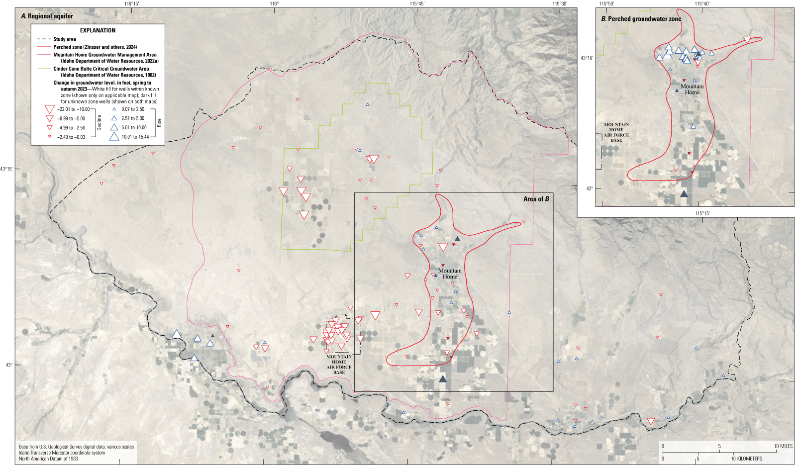
Change in groundwater level from spring to autumn 2023 for (A), the regional aquifer and (B), the perched groundwater zone in the Mountain Home area, southern Idaho (Idaho Department of Water Resources, 2024a; U.S. Geological Survey, 2024; Zinsser and others, 2024).
In general, groundwater level in most wells in the regional aquifer declined (0.03 to 22.01 ft) from spring 2023 to autumn 2023. In the Cinder Cone Butte Critical Groundwater Area, groundwater-level declines ranged from 0.08 ft in the most upgradient well to 20.04 ft in the most down gradient well (fig. 14A). Groundwater levels declined in all wells near the Mountain Home Air Force Base with declines ranging from 3.33 ft to 10.63 ft. There was less change in groundwater levels east of the City of Mountain Home and in the far western study area where substantial groundwater withdrawals have not been developed. Groundwater levels rose from 5.70 ft to 11.09 ft in wells near the City of Grand View, likely due to recharge from applied irrigation water from the Snake River. Groundwater levels in the communities of King Hill, Hammett, and the City of Glenns Ferry rose in wells near the Snake River and declined distally; rises may occur in areas where surface water is used to irrigate, and declines may occur in areas with less surface-water irrigation and (or) more intensive groundwater withdrawals.
Groundwater storage change over the 2023 irrigation season was estimated using groundwater levels measured in the spring and autumn 2023 synoptics. Storage change estimates are provided for five regions: (1) the Cinder Cone Butte Critical Groundwater Area, (2) the Mountain Home Groundwater Management Area (which legally excludes [1]), (3) the combined groundwater management areas, (4) the study area excluding the two groundwater management areas, and (5) the perched groundwater zone. The autumn 2023 regional and perched groundwater zone water tables were intersected with the three-dimensional hydrogeologic framework model; the percentage of each hydrogeologic framework unit within this intersected surface is provided in table 5. The estimated storage change in acre-ft is provided in table 6 along with a range of estimates using the lower and upper values of storativity (table 2). Groundwater storage in the combined groundwater management areas is estimated to have declined 37,310 acre-ft (8,860 to 64,930 acre-ft) from groundwater withdrawals during the 2023 irrigation season (table 6). This estimate is broadly consistent with a previous annual withdrawal estimate of 43,000 acre-ft (SPF Water Engineering LLC, 2017) and an annual water-budget deficit of 30,900 acre-ft (Harrington, 2004). Groundwater storage in the study area excluding the combined groundwater management areas is estimated to have increased 4,810 acre-ft (1,230 to 10,670 acre-ft; table 6). The groundwater storage in the perched zone is estimated to have increased 6,390 acre-ft (1,410 to 11,690 acre-ft; table 6).
Table 5.
Hydrogeologic unit percentage in the three-dimensional hydrogeologic framework model that intersects the autumn 2023 potentiometric surface, Mountain Home area, southern Idaho.[Data in table are derived from Zinsser and others, 2024. Values given in percent and may not add to 100 because of rounding. Shading present for visual grouping.]
Table 6.
Estimated change in groundwater storage between spring and autumn 2023, Mountain Home area, southern Idaho.[Data in table are derived from Zinsser and others, 2024.]
Storativity values from table 2.
The IDWR maintains a network of groundwater-level monitoring wells in the “Mountain Home plateau” which have long-term groundwater-level data since 1960 (fig. 15). Hydrographs of groundwater altitudes for selected wells show different interannual and long-term changes depending on the location and depth of the well. In general, regional aquifer wells in the Cinder Cone Butte Critical Groundwater Area, City of Mountain Home, and Mountain Home Air Force Base have declined since 1980 (figs. 16, 17). In contrast, groundwater levels along the “Snake River canyon” in the community of Hammett and the City of Glenns Ferry (fig. 18) and in the perched groundwater zone near the City of Mountain Home (fig. 19) do not show long-term declines.
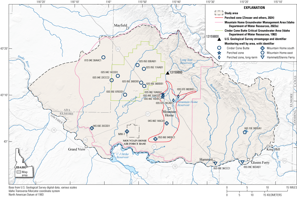
Location of long-term groundwater-level monitoring wells in the Mountain Home area, southern Idaho (Zinsser and others, 2024).
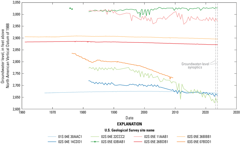
Hydrographs for long-term groundwater-level monitoring wells near the Cinder Cone Butte Critical Groundwater Area, southern Idaho (Idaho Department of Water Resources, 2024a).
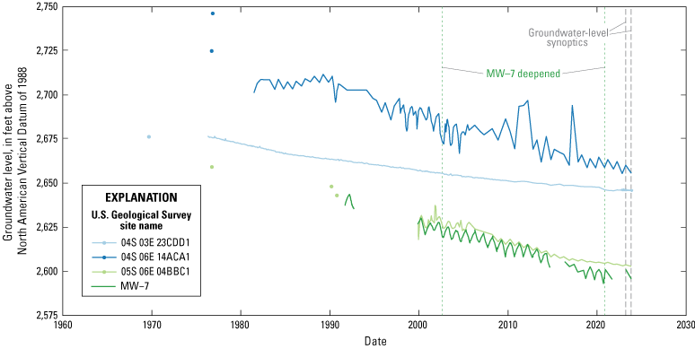
Hydrographs for long-term groundwater-level monitoring wells south of the City of Mountain Home and on the Mountain Home Air Force Base, southern Idaho (Idaho Department of Water Resources, 2024a). MW-7 was deepened and includes well station names 04S 05E 29CBBC1-DESTROYED, 04S 05E 29CBBC2 MW 7-2, and 04S 05E 29BCB1 MW 7-3.
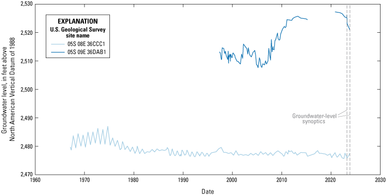
Hydrographs for long-term groundwater-level monitoring wells near the community of Hammett and the City of Glenns Ferry, southern Idaho (Idaho Department of Water Resources, 2024a).
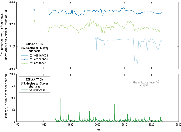
Hydrographs for U.S. Geological Survey site 13159800 Canyon Creek and long-term groundwater-level monitoring wells in the perched groundwater zone near the City of Mountain Home, southern Idaho (Idaho Department of Water Resources, 2024a; U.S. Geological Survey, 2024).
Wells in the Cinder Cone Butte Critical Groundwater Area have the greatest groundwater-level declines in the study area, with wells in the southwestern part of the critical groundwater area (03S 05E 07BDD1, 02S 04E 22CCC2; fig. 15) showing declines of over 100 ft since about 1980 (fig. 16). Wells in the eastern part of Cinder Cone Butte Critical Groundwater Area (02S 05E 26BDB1, 02S 05E 36BBB1) do not show the same magnitude of long-term change as those within the south and west but have nonetheless declined since 1980. In a well located northwest of the Cinder Cone Butte Critical Groundwater Area (01S 04E 30AAC1; fig. 15), groundwater level rose until 2000 (about 7 ft from 1967 to 2000) and then has declined since (about 7.5 ft from 2000 to 2023; fig. 16). These recent declines could be related to the groundwater in these wells being captured in the cone of depression within the Cinder Cone Butte Critical Groundwater Area since 2000 (Tesch, 2013). Wells north of I−84 but within the critical groundwater area boundary show no decline (02S 05E 03BAB1) or an overall decline (02S 05E 11AAB1) which is a third of the magnitude of the declines observed in wells in the southwest part of the Cinder Cone Butte Critical Groundwater Area (03S 05E 07BDD1, 02S 04E 22CCC2) over the period of record (figs. 15, 16).
Groundwater levels have also declined over 50 ft since 1980 in wells south of the City of Mountain Home and in the vicinity of Mountain Home Air Force Base (fig. 17). In the eastern part of the study area, well 04S 10E 30BBA1 declined about 15 ft between about 1968 and 1988 but has been stable overall since with periods of small declines and recovery (fig. 20). Similarly, monitoring wells near the community of Hammett and the City of Glenns Ferry (05S 08E 36CCC1, 05S 09E 36DAB1) showed relatively stable groundwater levels, although groundwater levels in well 05S 09E 36DAB1 rose from 2006 to 2012 (fig. 18). Since other monitoring wells did not experience the same pattern, this rise in water-level may be related to local changes in irrigation or pumping practices.
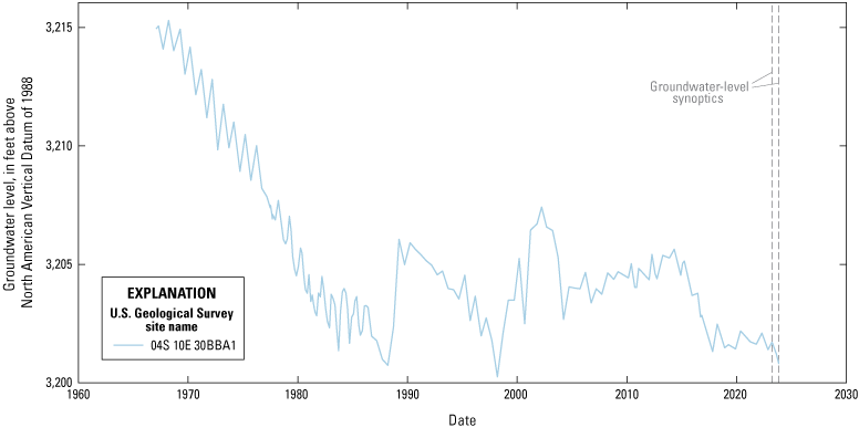
Hydrograph for long-term groundwater-level monitoring well east of the City of Mountain Home, southern Idaho (Idaho Department of Water Resources, 2024a).
Since the 1970s, long-term groundwater monitoring wells in the perched groundwater zone showed short periods of decline (over several years) followed by recovery within a few years that resulted in overall stable groundwater levels (fig. 19). Periods of decline and recovery seem to be related to periods of abundance or lack of surface water, as indicated by the streamflow in Canyon Creek (fig. 19). For example, groundwater-level declines in the early-1990s are associated with very low streamflow, followed by the return of high streamflow and groundwater-level recovery in the mid-1990s (fig. 19). Starting in 2016, during spring runoff in years of high flow, streamflow has been intentionally diverted from Canyon Creek for groundwater recharge. Continuous groundwater-level measurements show a sharp increase in groundwater level during times of diversion, and recovery of groundwater levels during the spring runoff of Canyon Creek in general even during years without diversions (fig. 21). Taken together, these patterns suggest the importance of surface-water supply to recharge the perched groundwater zone.
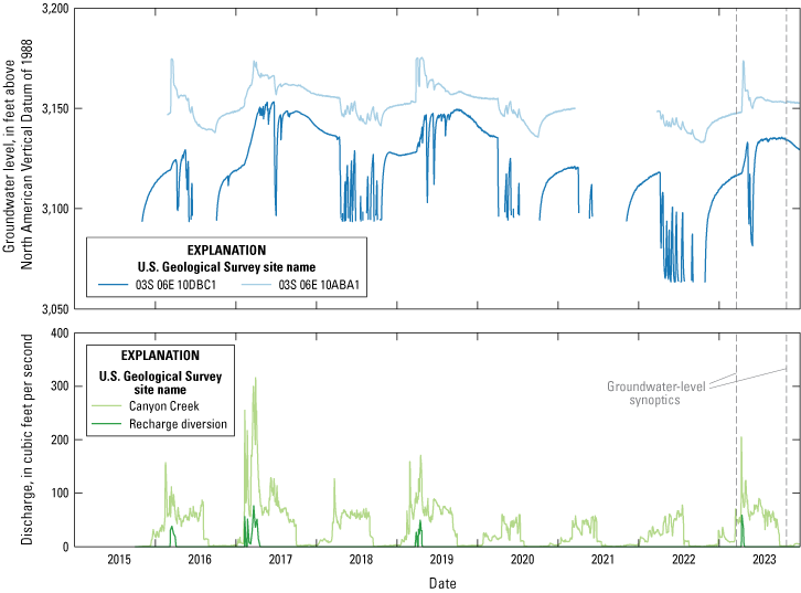
Hydrographs for U.S. Geological Survey site 13159800 Canyon Creek, managed recharge, and groundwater-level monitoring wells since 2016 in the perched groundwater zone near the City of Mountain Home, southern Idaho (Idaho Department of Water Resources, 2024a; U.S. Geological Survey, 2024).
Insights and Data Gaps
Insights derived from the borehole database, three-dimensional hydrogeologic framework model, groundwater-level synoptics, and published literature are synthesized here to describe key hydrogeologic processes pertinent to groundwater management in the study area. Data gaps that limit interpretations are also described.
Perched Groundwater Zone
Perched groundwater has been described around the City of Mountain Home since at least the 1950s, when Nace and others (1957) described perched water occurring in shallow gravels that was recharged by underflow and losses from irrigation and local streams. Nace and others (1957) also recognized that impermeable basalts, caliche, and fine sediments could create perching conditions, whereas permeable basalts and sediments would allow percolation to the regional aquifer. Ralston and Chapman (1968) described an area of shallow (less than 300 ft) well development in the Mountain Home area with perching conditions caused by a series of clay lenses and a clay layer on top of basalt. Young (1977) recognized perched conditions in multiple locations along the range front within the study area, with recharge derived from surface water and irrigation, suggesting that such leakage was responsible for the formation of the perched zones, and explicitly delineated the approximate area of the perched water zones. Later researchers largely adopted this (Norton and others, 1982; Bendixsen, 1994) or a similar (Lindholm and others, 1988) delineation and described the perched groundwater zone around the City of Mountain Home as occurring primarily in unconsolidated sediments (Norton and others, 1982; Bendixsen, 1994; SPF Water Engineering LLC, 2017).
The three-dimensional hydrogeologic model demonstrates that shallow fine-grained and coarse-grained sediments units underlying the City of Mountain Home are largely discontinuous (figs. 5, 8). A query of the borehole database to identify the lithology of shallow (less than 150 ft) units identified in the well-driller reports as water-bearing around the City of Mountain Home lends insight into the perched zone (table 7). Most of the perched units, particularly north of I−84 and west of U.S. Route 20, occur in basalt or cinders subunits approximately 30–100 ft below the surface, whereas perched water is noted in shallower (0–25 ft below the surface) sand and gravel subunits south of I−84 (figs. 22, 23). Basalt (undifferentiated) is the most common subunit described by drillers as not bearing water below a shallow water-bearing unit (table 7; fig. 23). This suggests that there is not an extensive fine-grained sediment unit creating perching conditions in many locations, although it is possible that minor fine-grained sediments (such as a thin soil over basalt) could contribute to perching conditions but potentially be missed in well-driller reports. Thus, based on these observations, perched groundwater near the City of Mountain Home occurs at multiple altitudes, primarily in basalt and some shallow unconsolidated sediments, and is most commonly underlain by basalt.
Table 7.
Summary of hydrogeologic units and subunits containing perched groundwater and the hydrogeologic units perching the groundwater, Mountain Home area, southern Idaho.[Data in table are summarized from Zinsser and others, 2024. From the borehole database, 72 boreholes contain a hydrogeologic unit identified as having water at a depth less than 150 feet with an unsaturated unit below. Some boreholes penetrate multiple perched units. Shading present for visual grouping. --, not assigned]

Distribution of shallowest hydrogeologic units with perched groundwater in boreholes near the City of Mountain Home, southern Idaho (Zinsser and others, 2024).
Depth to water and hydrogeologic unit or subunit with and underlying perched groundwater in boreholes near the City of Mountain Home, southern Idaho (Zinsser and others, 2024).
The lack of an extensive fine-grained sediments unit makes the lateral extents of perched groundwater conditions near the City of Mountain Home uncertain. It is unclear what method Young (1977) used to derive the approximate outline of the perched unit as the boundary extends beyond the shallow groundwater-level data in that study’s map. Figure 24 shows an updated perched groundwater zone outline based on: (1) 2023 synoptic groundwater-level data, (2) USGS groundwater-level data since 1955, and (3) wells with water-bearing units less than 150 ft deep identified in the borehole database. There is also an interesting concurrence of the original perched groundwater zone delineation with the surficial mapping of a coarse-grained sediments unit (Lewis and others, 2012) and the location of major irrigation infrastructure (fig. 24). The importance of local surface-water recharge to the occurrence of perched groundwater near the City of Mountain Home has long been recognized (Nace and others, 1957; Young, 1977; Norton and others, 1982). Additional areas of shallow groundwater levels that fit neither the perched groundwater zone near the City of Mountain Home nor the regional aquifer were identified in the groundwater synoptics (fig. 13A, B); these areas generally occur along the range front and are consistent with outlying perched groundwater zone locations described by Young (1977) and Lindholm and others (1988). While all of these methods are imperfect to delineate the zone within which perched groundwater conditions may occur, they do generally agree.
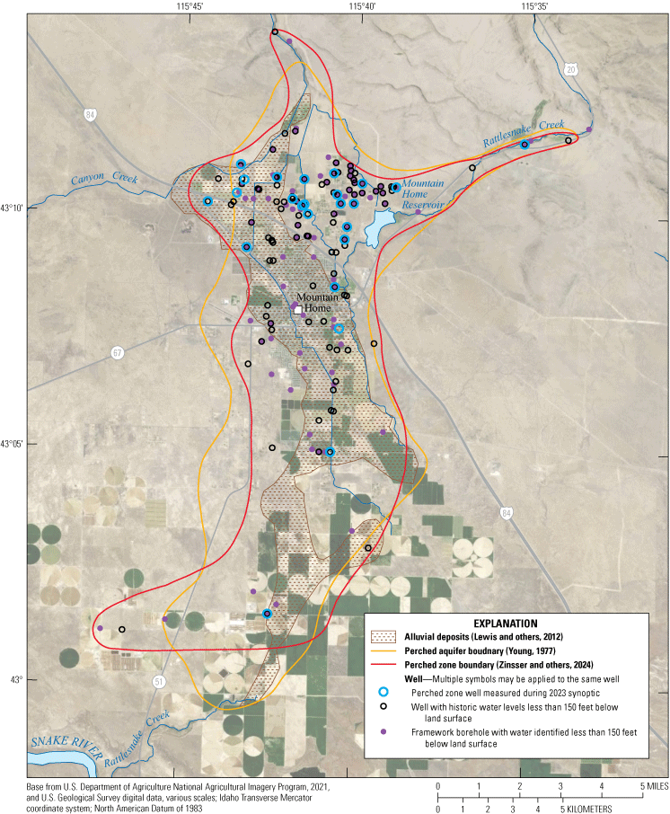
Lateral extent of the perched groundwater zone near the City of Mountain Home, southern Idaho (U.S. Geological Survey, 2024; Zinsser and others, 2024).
Conceptually, these findings suggest a system in which perched conditions can occur at multiple altitudes, locations, and units depending on the precise hydrogeologic conditions encountered in the subsurface and contingent on proximal surface recharge (fig. 25). Precipitation falls on the mountains and foothills, feeding streams and infiltrating into the fractured rhyolite, basalt, and sediments via both deeper flow paths to the regional aquifer and shallow flow paths where local conditions allow. High hydraulic conductivity can occur within the basalt hydrogeologic unit along interflow zones (highly porous, broken zones between discrete flows), through vertical fissure networks (Anderson and others, 1999; Welhan and others, 2002), in scoria (Anderson and others, 1999), and through improperly constructed wells (wells open to multiple aquifer zones). The basalt hydrogeologic unit near the City of Mountain Home is highly complex, representing multiple overlapping shield volcanoes and cinder cone volcanic events (Shervais and others, 2002). In the subsurface, this complexity translates to intermittent zones with high horizontal hydraulic conductivity (for example, in interflow zones and horizontally distributed cinders), punctuated by zones of enhanced vertical hydraulic conductivity (for example, fissure networks and near-vent scoria) that allow perched groundwater to percolate downward toward the regional aquifer (fig. 25). Reported and measured water-levels at different altitudes supports the idea of multiple horizontal water-bearing units at different altitudes. The disappearance of perched groundwater conditions toward the south indicates the downward migration of perched groundwater to the regional aquifer, and vivid observations from Mountain Home Reservoir demonstrate the impact that vertical fractures can have on water loss (Harrington-Thornton, 1995). Aiming to eliminate “uncontrolled loss of reservoir water” (p. 3), the reservoir was drained and excavated to a depth of approximately 10 ft in 1995, revealing basalt bedrock with a large vertical fracture with a visible depth of at least 2–3 ft, which was then partially filled with concrete with two standpipes emplaced for managed recharge (Harrington-Thornton, 1995). The horizontal and vertical complexity in the basalt hydrogeologic unit, combined with abundant available recharge via streams, canals, and irrigation near the City of Mountain Home and near the range front, create complex zones of perched groundwater.
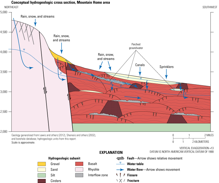
Conceptual hydrogeologic cross section near the City of Mountain Home, southern Idaho. Cross section represents generalized conditions in the vicinity of cross section C–C’ shown in figure 4.
Faulting and Geothermal
Faulting likely impacts water occurrence and movement within the study area in variable ways, including enhancing local water production, altering hydraulic conductivity, or offsetting water-bearing zones, depending on the location. While the locations of some faults are known through geologic mapping (Lewis and others, 2012; Phillips and others, 2012) and subsurface geophysical surveys (Liberty, 2012; fig. 2), the location and impact on hydrology of other faults is inferred from various lines of evidence. A likely fault was identified during the development of the borehole database, where two newly drilled wells (473257 and 473699; Zinsser and others, 2024) in the same housing development south of Mayfield had a difference in static groundwater levels of over 110 ft despite being located only about 1,700 ft apart. Similarly, these wells had offset groundwater levels (112 ft) when measured as part of the autumn 2023 synoptic. It is possible that the fault offsets a water-bearing unit, resulting in the lower groundwater level on the down-dropped sediments south of the fault, and (or) that the fault created a zone of decreased hydraulic conductivity, causing lower groundwater levels on the downgradient side of the fault (fig. 26). Down-dropping to the southwest is generally consistent with regional faulting although the offset is not clearly resolvable in the unconsolidated sediment units described in the well-driller reports. A similar aquifer-offsetting fault was inferred by Norton and others (1982) along I−84 between Orchard and the City of Mountain Home. Faults interpreted by Liberty (2012) near Mayfield offset the granitic bedrock surface by 100–300 ft and dip steeply to the southwest, and offset water-table reflectors in a seismic profile south of Indian Creek suggest a buried fault offsetting the water table (Liberty, 2012). Thus, there exists evidence in geophysical data, groundwater-level data, and borehole lithology to suggest that unmapped faults can inhibit groundwater movement, lowering the water surface altitude on the down-dropped and down-gradient side of the faults.
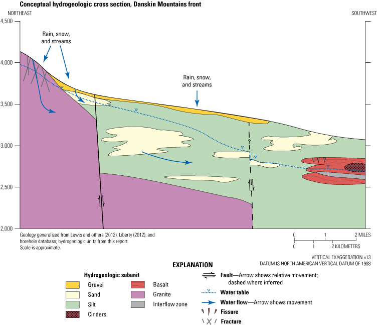
Conceptual hydrogeologic cross section west of the City of Mountain Home, southern Idaho. Cross section represents generalized conditions in the vicinity of cross section D–D’ shown in figure 4.
There is also evidence to suggest that faults may enhance groundwater movement within the study area. Welhan and others (2002) interpreted steepened groundwater-surface gradients along the range front as an indication of deep groundwater recharge along faults; this hypothesis is supported by some geochemical data indicating deep geothermal water may contribute to aquifer recharge in the Mayfield area (Hopkins, 2013). In the eastern study area, groundwater levels in a series of deep, artesian geothermal wells are likely controlled by a series of faults. These wells have been subject to extensive litigation, study, and decree since the 1960s. Lithology descriptions in the well-driller reports are ambiguous, with rocks described by color (variously, grey, black, red, green, and cream) and competency (hard, broken), but generally the wells are interpreted to be completed within faulted silicic-volcanic rocks (Castelin, 1993) which is consistent with area geology (Lewis and others, 2012). Three wells (424832, 424830, and 352841) are hydraulically connected, while a fourth well (423043) is not (fig. 12; Castelin and MacAllister, 1978; Castelin, 1993) and is completed in a sand unit. Confining conditions are likely caused by overlying fine-grained sediments, which are variously described as clay or shale, with water supplied and heated via deep flow paths and transmitted by faults (fig. 27). The occurrence of multiple, unconnected geothermal artesian zones suggests multiple faults may be present. However, artesian flow at the connected wells is seasonal, and in practice, flow occurs at lower rates than the decreed volumes (Castelin, 1993). Extensive exploration of deep geothermal water resources has been undertaken on the Mountain Home Air Force Base (Shervais and others, 2012) but this resource is not being used at present. Thus, while there is evidence of deep geothermal recharge to the aquifer in some areas, there is not compelling evidence that this represents a substantiative source of water to the regional aquifer. Whether enhancing or inhibiting groundwater flow, it is likely that additional unmapped faults occur within the study area and may affect groundwater occurrence and movement.
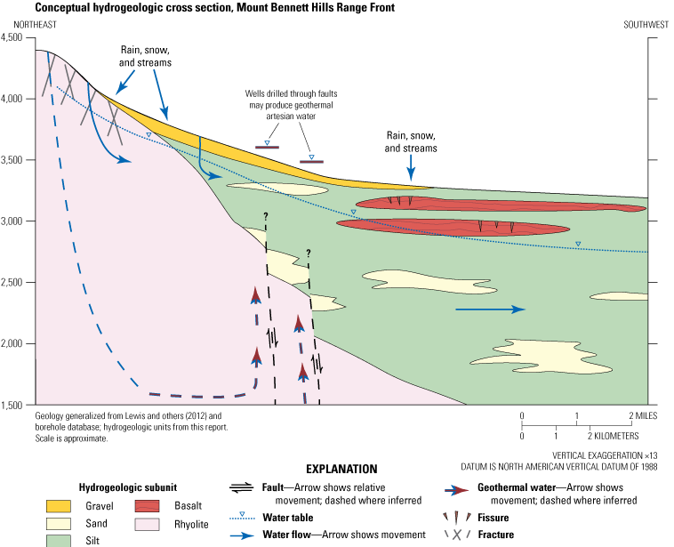
Conceptual hydrogeologic cross section east of the City of Mountain Home, southern Idaho. Cross section represents generalized conditions in the vicinity of cross section B–B’ shown in figure 4.
Data Gaps
Data gaps and limitations in our knowledge of the study area remain. In the three-dimensional hydrogeologic framework model, units below the mountains are poorly represented, and units in the southwestern study area and greater than 1,000 ft below land surface are largely unconstrained because of a lack of borehole data in these areas. Faults are not represented within the model, and the full scope of fault influence on groundwater movement is unknown. Similarly, the importance of deep geothermal recharge to the regional aquifer is not well understood. Generally, the three-dimensional hydrogeologic framework model represents the hydrogeologic conditions best where there is abundant borehole data (for example, at depths less than 1,000 ft and where there are many boreholes) but poorly represents large-scale geologic relations (for example, range front contacts). In contrast, the conceptual diagrams represent large-scale geologic relations (for example, faults, contacts between bedrock and sediments) more accurately but generalize near-surface conditions to demonstrate conceptual understanding of water movement.
In the water-table contour map, there is limited primary groundwater data in the eastern and southwestern study area and in the mountains and foothills because of a lack of wells and (or) the inability to access and measure existing wells. Many wells in the perched groundwater zone are open to multiple units, which obscures understanding of perched and regional groundwater levels and may contribute to the observation of groundwater levels that do not clearly belong to either zone. Similarly, the relative importance of precipitation, mountain front recharge, and incidental surface recharge to the persistence of the perched groundwater zone is not well understood. Installation of wells which intentionally isolate the perched groundwater zone and regional aquifer would be helpful for understanding the dynamics of each, and in resolving vertical groundwater gradients. A study evaluating sites for a water supply well for the City of Mountain Home estimated transmissivity of 58,580 ft2/d (6,760–481,450 ft2/d) from 18 well tests (Brockway Engineering, 2019). Nonetheless, estimates of transmissivity within the study area are limited and additional aquifer tests could be helpful for potential future numerical groundwater modeling, particularly if such estimates were clearly tied to distinct hydrogeologic units.
Summary
The U.S. Geological Survey developed a hydrogeologic framework for the western Snake River Plain near the City of Mountain Home, Idaho and surrounding area. There are five hydrogeologic units: granite, rhyolite, basalt, fine-grained sediments, and coarse-grained sediments. Each hydrogeologic unit bears water, but the main regional aquifer is hosted in the basalt and fine-grained sediments units. A perched groundwater zone near the City of Mountain Home is primarily hosted in permeable basalt horizons and perched by massive basalt flows. Heterogeneity within the basalt exerts strong control on groundwater movement within this hydrogeologic unit, with interflow zones forming areas with high horizontal conductivity, massive basalt flows creating perching conditions, and fissures and near-vent cinders causing zones of enhanced vertical conductivity to allow downward percolation of groundwater. There is evidence for inferred faults impeding or enhancing groundwater movement in the fine- and coarse-grained sediments and rhyolite hydrogeologic units in different locations, and it is likely that additional unmapped faults occur within the study area and may affect groundwater movement. The three-dimensional hydrogeologic framework model was built from 540 boreholes and additional points representing the surface expression of the hydrogeologic units. The model reasonably represents the expected spatial distribution of hydrogeologic units in the subsurface, although hydrogeologic unit representation is poor where borehole data are sparse (for example, under the mountains and at depths greater than 1,000 feet). Water-table and groundwater-level change maps were developed based on groundwater levels from 180 wells measured in March and November 2023. Groundwater generally flows south-southwest to the Snake River. Groundwater levels in most wells declined from spring to autumn 2023, with the largest declines observed in the Cinder Cone Butte Critical Groundwater Area. Groundwater levels rose in most wells in the perched groundwater zone near the City of Mountain Home and in some wells near the Snake River, areas where surface-water irrigation occurs, suggesting the importance of surface-water recharge to groundwater levels in these places. Groundwater storage change between spring and autumn 2023 was estimated to be –37,310 acre-feet in the combined Cinder Cone Butte Critical Groundwater Area and Mountain Home Groundwater Management Area based on measured groundwater-level change and storage change estimated by hydrogeologic unit. In summary, this hydrogeologic framework provides an updated characterization of and new insights into the groundwater resources in the western Snake River Plain around the City of Mountain Home. This information can be used to help inform water resources management in the study area and provides the conceptual basis for a potential future numerical groundwater flow model.
References Cited
Ackerman, D.J., Rattray, G.W., Rousseau, J.P., Davis, L.C., and Orr, B.R., 2006, A conceptual model of ground-water flow in the eastern Snake River Plain aquifer at the Idaho National Laboratory and vicinity with implications for contaminant transport: U.S. Geological Survey Scientific Investigations Report 2006–5122, 62 p., accessed July 6, 2020, at https://doi.org/10.3133/sir20065122.
Ahmadi, S.H., and Sedghamiz, A., 2007, Geostatistical analysis of spatial and temporal variations of groundwater level: Environmental Monitoring and Assessment, v. 129, p. 277–294, accessed June 25, 2024, at https://doi.org/10.1007/s10661-006-9361-z.
Air Force Civil Engineer Center, 2022, 2021 annual long-term monitoring report sites SD024 and SS011, Operable Unit 3 regional groundwater and bedrock vapor extraction Mountain Home Air Force Base, Idaho: Air Force Civil Engineer Center and U.S. Army Corps of Engineers, prepared by HydroGeoLogic, Inc., 184 p., accessed January 19, 2024, at https://ar.afcec-cloud.af.mil/.
Anderson, S.R., Kuntz, M.A., and Davis, L.C., 1999, Geologic controls of hydraulic conductivity in the Snake River Plain aquifer at and near the Idaho National Engineering and Environmental Laboratory, Idaho: U.S. Geological Survey Water Resources Investigation Report 99–4033, 38 p., accessed April 25, 2024, at https://doi.org/10.3133/wri994033.
Antonakos, A., and Lambrakis, N., 2021, Spatial interpolation for the distribution of groundwater level in an area of complex geology using widely available GIS tools: Environmental Processes, v. 8, p. 993–1026, accessed June 25, 2024, at https://doi.org/10.1007/s40710-021-00529-9.
Arney, B.H., Gardner, J.N., and Belluomini, S.G., 1984, Petrographic analysis and correlation of volcanic rocks in Bostic 1-A well near Mountain Home, Idaho: Los Alamos, N. Mex., Los Alamos National Laboratory, 37 p., accessed September 9, 2022, at https://doi.org/10.2172/5228770.
Bartolino, J.R., 2019, Hydrogeologic framework of the Treasure Valley and surrounding area, Idaho and Oregon: U.S. Geological Survey Scientific Investigations Report 2019–5138, 31 p., accessed June 24, 2024, at https://doi.org/10.3133/sir20195138.
Bendixsen, S., 1994, Summary of hydrologic conditions in the Mountain Home and Cinder Cone Butte areas: Boise, Idaho, Idaho Department of Water Resources, 17 p., accessed September 17, 2021, at https://idwr.idaho.gov/wp-content/uploads/sites/2/publications/199404-OFR-gw-conditions-mhgwma.pdf.
Bonnichsen, B., Boroughs, S., Godchaux, M.M., and Wolff, J., 2016, From land to lake—Basalt and rhyolite volcanism in the western Snake River Plain, Idaho, in Lewis, R.S., and Schmidt, K.L., eds., Exploring the Geology of the Inland Northwest: Geological Society of America, p. 99–125. [Also available at https://doi.org/10.1130/2016.0041(03).]
Bonnichsen, B., and Jenks, M.D., 1990, Geologic map of the Jarbidge River Wilderness study area, Owyhee County, Idaho: U.S. Geological Survey Miscellaneous Field Studies Map MF–2127, 1 sheet, scale 1:50,000, accessed March 16, 2023, at https://doi.org/10.3133/mf2127.
Brockway Engineering, 2019, Update to hydrogeologic assessment of potential well sites for the City of Mountain Home, appendix I of City of Mountain Home Water Facilities Planning Study: City of Mountain Home, Idaho, p. 1–10 [appendix parts separately paged], accessed June 25, 2024, at https://mountain-home.us/content/uploads/2020/02/214010-020-mtn-home-2019-10-31-wfps-report.pdf.
Castelin, P.M., 1993, Two-Plus aquifer test results: Idaho Department of Water Resources memorandum, 8 p., accessed June 24, 2024, at https://research.idwr.idaho.gov/apps/waterrights/relateddocs/relateddocs.asp?Basin=61&Sequence=302.
Castelin, P.M., and MacAllister, W.H., 1978, Results of Walker-Lee-Two-Plus well test, Elmore County, Idaho: Idaho Department of Water Resources Open-File Report, 24 p., accessed June 24, 2024, at https://research.idwr.idaho.gov/apps/waterrights/relateddocs/relateddocs.asp?Basin=61&Sequence=302.
Chapman, S.L., and Ralston, D.R., 1970, Ground-water resource of the Blue Gulch area in eastern Owyhee and western Twin Falls Counties, Idaho: Idaho Department of Water Administration, Water Information Bulletin, no. 20, 40 p., accessed June 10, 2024, at https://idwr.idaho.gov/wp-content/uploads/sites/2/publications/wib20-water-res-blue-gulch-area-id.pdf.
Clemens, D.M., and Wood, S.H., 1993, Late Cenozoic volcanic stratigraphy and geochronology of the Mount Bennett Hills, central Snake River Plain, Idaho: Isochron/West—A Bulletin of Isotopic Geochronology, v. 60, p. 3–14, accessed December 20, 2023, at https://geoinfo.nmt.edu/publications/periodicals/isochronwest/60/iw_v60_p03.pdf.
Cunningham, W.L., and Schalk, C.W., 2011, Groundwater technical procedures of the U.S. Geological Survey: U.S. Geological Survey Techniques and Methods 1–A1, 151 p., accessed June 24, 2024, at https://doi.org/10.3133/tm1A1.
Esri, 2024, ArcGIS Pro, version 3.2.2: Esri software release, accessed February 8, 2024, at https://pro.arcgis.com/en/pro-app/3.2/get-started/download-arcgis-pro.htm.
Godchaux, M.M., and Bonnichsen, B., 2002, Syneruptive magma-water and posteruptive lava-water interactions in the western Snake River Plain, Idaho, during the past 12 million years, in Bonnichsen, B., White, C.M., and McCurry, M., eds., Tectonic and magmatic evolution of the Snake River Plain volcanic province: Moscow, Idaho, Idaho Geological Survey bulletin 30, p. 387–434. [Also available at https://www.idahogeology.org/pub/Bulletins/Snake_River_Plain_B-30.pdf.]
Harrington, H., 2004, Mountain Home Plateau—Groundwater conditions and management activities: Idaho Department of Water Resources, presentation to the Idaho Legislature Natural Resources Interim Committee, 24-slide presentation, accessed June 24, 2024, at https://legislature.idaho.gov/wp-content/uploads/sessioninfo/2004/interim/mtnhomeplateau.pdf.
HDR, 2024, 2023 annual water level monitoring report: Idaho Department of Water Resources, prepared by HDR, 7 p., accessed February 13, 2024, at https://research.idwr.idaho.gov/apps/Shared/LfRelatedDocs/Home/SearchWrGet?Basin=61&Sequence=12090&SplitSuffix=.
Hopkins, C.B., 2013, Recharge sources and residence times of groundwater as determined by geochemical tracers in the Mayfield Area, southwestern Idaho, 2011–12: U.S. Geological Survey Scientific Investigations Report 2013–5115, 46 p., accessed June 24, 2024, at https://doi.org/10.3133/sir20135115.
Hundt, S.A., and Bartolino, J.R., 2023, Groundwater-flow model of the Treasure Valley, southwestern Idaho, 1986–2015: U.S. Geological Survey Scientific Investigations Report 2023–5096, 107 p., accessed June 22, 2024, at https://doi.org/10.3133/sir20235096.
Idaho Department of Water Resources, 1981, Order establishing Critical Groundwater Area—In the matter of the Cinder Cone Butte Critical Groundwater Area: Idaho Department of Water Resources Order, 2 p., accessed October 14, 2021, at https://idwr.idaho.gov/wp-content/uploads/sites/2/legal/orders/1981/19810507-Order-Establishing-Cinder-Cone-Butte-CGWA.pdf.
Idaho Department of Water Resources, 1982, Order establishing Ground Water Management Area—In the matter of the Mountain Home Groundwater Management Area: Idaho Department of Water Resources Order, 2 p., accessed October 14, 2021, at https://idwr.idaho.gov/wp-content/uploads/sites/2/legal/orders/1982/19821109-Order-Creating-Mountain-Home-GWMA.pdf.
Idaho Department of Water Resources, 2022a, Groundwater Management Areas: Idaho Department of Water Resources geospatial data, accessed April 1, 2024, at https://data-idwr.hub.arcgis.com/maps/a247bfcfc6a1412c873e7a4c7a9b8e53/about.
Idaho Department of Water Resources, 2022b, IDWR Administrative Basins: Idaho Department of Water Resources geospatial data, accessed April 1, 2024, at https://data-idwr.hub.arcgis.com/maps/e7c1231b38ef4412bc69b077be9ac610/about.
Idaho Department of Water Resources, 2023, Wells: Idaho Department of Water Resources geospatial data, accessed April 15, 2024, at https://data-idwr.hub.arcgis.com/maps/8fd1bf9b7af247d5a5987dbe728a4656/explore.
Idaho Department of Water Resources, 2024a, Groundwater data portal: Idaho Department of Water Resources database, accessed February 14, 2024, at https://data-idwr.hub.arcgis.com/documents/IDWR::groundwater-level-data-all-historic-data/about.
Idaho Department of Water Resources, 2024b, Well construction search: Idaho Department of Water Resources database, accessed April 15, 2024, at https://research.idwr.idaho.gov/apps/wellconstruction/wcinfosearchexternal/.
Idaho Department of Water Resources, 2024c, MHAFB Water Resilience Project: Idaho Water Resource Board, Modernizing Idaho's water infrastructure, no. 2, 2 p., accessed December 26, 2024, at https://idwr.idaho.gov/wp-content/uploads/sites/2/iwrb/MHAFB/Mountain-Home-AFB-Water-Resiliency-Project-FINAL.pdf.
Idaho Legislature, 2008a, Idaho Statute 42–1779—Statewide comprehensive aquifer planning and management effort, in chap. 17, Department of Water Resources—Water Resource Board of Title 42, Irrigation and drainage: Idaho Statutes, accessed April 15, 2024, at https://legislature.idaho.gov/statutesrules/idstat/Title42/T42CH17/SECT42-1779/. [42-1779, added 2008, ch. 134, sec. 2, p. 377.]
Idaho Legislature, 2008b, Idaho Statute 42–1780—Aquifer planning and management fund—Secondary aquifer planning, management and implementation fund, in chap. 17, Department of Water Resources—Water Resource Board of Title 42, Irrigation and drainage: Idaho Statutes, accessed April 15, 2024, at https://legislature.idaho.gov/statutesrules/idstat/Title42/T42CH17/SECT42-1780/. [42-1780, added 2008, ch. 321, sec. 3, p. 890; am. 2010, ch. 356, sec. 1, p. 934.]
Idaho State Geological Survey, 2024, Idaho Geological Survey interactive maps: Idaho Geological Survey website, accessed April 15, 2024, at https://www.idahogeology.org/WebMap4/.
Isensee, A.R., Johnson, L., Thornhill, J., Nicholson, T.J., Meyer, G., Vecchioli, J., and Laney, R., 1989, Subsurface-water flow and solute transport—Federal glossary of selected terms: Reston, Va., U.S. Geological Survey Federal Glossary of Selected Terms, Prepared for the Ground Water Subcommittee of the Federal Interagency Advisory Committee on Water Data, 38 p., accessed June 24, 2024, at https://doi.org/10.3133/70100276.
Jenks, M.D., and Bonnichsen, B., 1989, Subaqueous basalt eruptions into Pliocene Lake Idaho, Snake River Plain, Idaho, in Chamberlain, V.E., Breckenridge, R.M., and Bonnichsen, B., eds., Guidebook to the geology of northern and western Idaho and surrounding area: Moscow, Idaho, Idaho Geological Survey Bulletin 28, p. 17–34. [Also available at https://idahogeology.org/pub/Bulletins/B-28.pdf.]
Jenks, M.D., Bonnichsen, B., and Godchaux, M.M., 1998, Geologic map of the Grand View-Bruneau area, Owyhee County, Idaho: Moscow, Idaho, University of Idaho, Idaho Geological Survey technical report 98-1, 1 sheet, scale 1:100,000, 21-p. pamphlet, accessed February 24, 2023, at https://www.idahogeology.org/product/T-98-1.
Júnez-Ferreira, H.E., Hernández-Hernández, M.A., Herrera, G.S., González-Trinidad, J., Cappello, C., Maggio, S., and De Iaco, S., 2023, Assessment of changes in regional groundwater levels through spatio-temporal kriging—application to the southern Basin of Mexico aquifer system: Hydrogeology Journal, v. 31, no. 6, p. 1405–1423, accessed June 25, 2024, at https://doi.org/10.1007/s10040-023-02681-y.
Lewis, R.E., and Stone, M.A., 1988, Geohydrologic data from a 4403-foot geothermal test hole, Mountain Home Air Force Base, Elmore County, Idaho: U.S. Geological Survey Open-File Report 88–166, 30 p., accessed September 17, 2021, at https://doi.org/10.3133/ofr88166.
Lewis, R.S., Link, P.K., Stanford, L.R., and Long, S.P., 2012, Geologic map of Idaho: Moscow, Idaho, University of Idaho, Idaho Geological Survey geologic map M-9, 1 sheet, scale 1:750,000, 18-p. pamphlet, accessed October 10, 2020, at https://www.idahogeology.org/product/m-9.
Liberty, L.M., 2012, Geophysical characterization at the north Ada and east Ada sites—A 2012 Idaho Department of Water Resources report: Boise, Idaho, Boise State University, 32 p., accessed April 30, 2024, at idwr.idaho.gov/wp-content/uploads/sites/2/projects/east-ada-county/Geophysical-Characterization-at-the-North-Ada-and-East-Ada-Sites-Liberty-2012.pdf
Lifton, Z.M., Ducar, S.D., and Tate, C.A., 2021, Landslide inventory database for Idaho: Moscow, Idaho, University of Idaho, Idaho Geological Survey digital databases 10, 70 p., accessed June 22, 2024, at https://idahogeology.org/pub/Digital_Data/Digital_Databases/DD-10_report.pdf.
Lindholm, G.F., Garabedian, S.P., Newton, G.D., and Whitehead, R.L., 1988, Configuration of the water table and depth to water, spring 1980, water-level fluctuations, and water movement in the Snake River Plain Regional Aquifer System, Idaho and eastern Oregon: U.S. Geological Survey Hydrologic Atlas HA–703, 1 plate, accessed September 17, 2021, at https://doi.org/10.3133/ha703. [Supersedes USGS Open-File Report 86–149.]
Mabey, D.R., 1982, Geophysics and tectonics of the Snake River Plain, in Bonnichsen, B., and Breckenridge, R.M., eds., Cenozoic geology of Idaho: Moscow, Idaho, Idaho Bureau of Mines and Geology Bulletin 26, p. 139–153. [Also available at https://idahogeology.org/pub/Bulletins/B-26Full.pdf.]
Malde, H.E., 1972, Stratigraphy of the Glenns Ferry Formation from Hammett to Hagerman, Idaho: U.S. Geological Survey Bulletin 1331–D, 19 p., 2 pls., accessed September 1, 2023, at https://doi.org/10.3133/b1331D.
Malde, H.E., and Powers, H.A., 1962, Upper Cenozoic stratigraphy of western Snake River Plain, Idaho: Geological Society of America Bulletin, v. 73, no. 10, p. 1197–1220, 1 pl., accessed February 21, 2023, at https://doi.org/10.1130/0016-7606(1962)73[1197:UCSOWS]2.0.CO;2.
Mann, L.J., 1986, Hydraulic properties of rock units and chemical quality of water for INEL-1 —A 10,365-foot deep test hole drilled at the Idaho National Engineering Laboratory, Idaho: U.S. Geological Survey Water-Resources Investigations Report 86–4020, accessed December 23, 2024, at https://doi.org/10.3133/wri864020.
McGrath, C.L., Woods, A.J., Omernik, J.M., Bryce, S.A., Edmondson, M., Nesser, J.A., Shelden, J., Crawford, R.C., Comstock, J.A., and Plocher, M.D., 2002, Ecoregions of Idaho: U.S. Geological Survey, 2 sheets, scale 1:1,350,000, accessed June 19, 2024, at https://www.epa.gov/eco-research/ecoregion-download-files-state-region-10.
McGuire, V.L., 2013, Water-level and storage changes in the High Plains aquifer, predevelopment to 2011 and 2009–11: U.S. Geological Survey Scientific Investigations Report 2012–5291, 15 p., accessed June 24, 2024, at https://pubs.usgs.gov/sir/2012/5291/. [Also available at https://doi.org/10.3133/sir20125291.]
Mundorff, M.J., Crosthwaite, E.G., and Kilburn, C., 1964, Ground water for irrigation in the Snake River Basin in Idaho: U.S. Geological Survey Water Supply Paper 1654, 240 p., accessed June 24, 2024, at https://doi.org/10.3133/wsp1654.
Nace, R.L., West, S.W., and Mowder, R.W., 1957, Feasibility of ground-water features of the alternate plan for the Mountain Home project, Idaho: U.S. Geological Survey Water Supply Paper 1376, 121 p., 7 pls., accessed September 17, 2021, at https://doi.org/10.3133/wsp1376.
Newhouse, M.W., and Hanson, R.T., 2002, Three-dimensional measurements of flow in uncased wells completed in basalt, Mountain Home Air Force Base, Idaho, March 2000: U.S. Geological Survey Water-Resources Investigation Report 2001–4259, 13 p., accessed June 3, 2022, at https://doi.org/10.3133/wri014259.
Newton, G.D., 1991, Geohydrology of the regional aquifer system, western Snake River Plain, southwestern Idaho: U.S. Geological Survey Professional Paper 1408–G, 52 p., 1 pl., accessed November 2, 2021, at https://doi.org/10.3133/pp1408G.
Norton, M.A., Ondrechen, W., and Baggs, J.L., 1982, Ground water investigation of the Mountain Home plateau: Idaho Department of Water Resources Open-File Report, 62 p., accessed December 2, 2024, at https://idwr.idaho.gov/wp-content/uploads/sites/2/publications/198208-OFR-gw-investigations-mthome-plateau-id.pdf.
Phillips, W.M., Lewis, R.S., Gillerman, V.S., Garwood, D.L., and Stewart, D.E., 2012, Geologic map of the Mayfield area, Ada and Elmore Counties, Idaho: Moscow, Idaho, Idaho Geological Survey digital map 144, 1 sheet, scale 1:36,000, accessed February 24, 2023, at https://idahogeology.org/pub/Digital_Data/Digital_Web_Maps/Mayfield_DWM-144-m.pdf.
Pierce, K.L., and Morgan, L.A., 1992, The track of the Yellowstone hot spot—Volcanism, faulting, and uplift, chap. 1 of Link, P.K., Kuntz, M.A., and Piatt, L.B., eds., Regional geology of eastern Idaho and western Wyoming: Geological Society of America Memoirs 179, 54 p. [Also available at https://doi.org/10.1130/MEM179-p1.]
Ralston, D.R., and Chapman, S.L., 1968, Ground-water resource of the Mountain Home area, Elmore County, Idaho: Idaho Department of Reclamation Water Information Bulletin no. 4, 63 p., 1 pl., accessed September 17, 2021, at https://idwr.idaho.gov/wp-content/uploads/sites/2/publications/wib04-gw-res-mthome-id.pdf.
Ramage, J.K., and Braun, C.L., 2023, Status of water-level altitudes and long-term and short-term water-level changes in the Chicot and Evangeline (undifferentiated) and Jasper aquifers, greater Houston area, Texas, 2022: U.S. Geological Survey Scientific Investigations Report 2023–5007, 26 p., accessed September 23, 2024, at https://doi.org/10.3133/sir20235007.
RockWare, 2023, RockWorks20 Standard, version 2024.03.30: RockWare software release, accessed December 23, 2024, at https://www.rockware.com/support/rockworks-support/rockworks-downloads/rockworks-archived-versions/.
Rydlund, P.H., Jr., and Densmore, B.K., 2012, Methods of practice and guidelines for using survey-grade global navigation satellite systems (GNSS) to establish vertical datum in the United States Geological Survey: U.S. Geological Survey Techniques and Methods 11–D1, 102 p., accessed September 23, 2024, at https://doi.org/10.3133/tm11D1.
Shervais, J.W., Nielson, D., Evans, J.P., Lachmar, T., Christiansen, E.H., Morgan, L., Shanks, W.C.P., Delahunty, C., Schmitt, D.R., Liberty, L.M., Blackwell, D.D., Glen, J.M., Kessler, J.A., Potter, K.E., Jean, M.M., Sant, C.J., and Freeman, T.G., 2012, Hotspot—The Snake River Geothermal Drilling Project initial report: Geothermal Resources Council Transactions, v. 26, p. 767–772, accessed August 23, 2022, at https://gdr.openei.org/submissions/127.
Shervais, J.W., Shroff, G., Vetter, S.K., Matthews, S., Hanan, B.B., and McGee, J.J., 2002, Origin and evolution of the western Snake River Plain—Implications from stratigraphy, faulting, and the geochemistry of basalts near Mountain Home, Idaho, in Bonnichsen, B., White, C.M., and McCurry, M., eds., Tectonic and magmatic evolution of the Snake River Plain volcanic province: Moscow Idaho, Idaho Geological Survey bulletin 30, p. 343–361. [Also available at https://www.idahogeology.org/pub/Bulletins/Snake_River_Plain_B-30.pdf.]
SPF Water Engineering LLC, 2007, Ground-water supply evaluation for the Mayfield Townsite Property: Boise, Idaho, Farwest LLC, prepared by SPF Water Engineering, LLC, Boise, Idaho, 145 p. (including 7 app.), accessed May 15, 2024, at https://idwr.idaho.gov/wp-content/uploads/sites/2/projects/east-ada-county/Groundwater-Supply-Evaluation-for-the-Mayfield-Townsite-Property-SPF-Water- Engineering-2007.pdf.
SPF Water Engineering LLC, 2016, Water supply planning report—Mountain Home Air Force Base Snake River water supply: Boise, Idaho, Idaho Water Resource Board, prepared by SPF Water Engineering, LLC, Boise, Idaho, 315 p. (including 4 app.), accessed September 17, 2021, at https://idwr.idaho.gov/wp-content/uploads/sites/2/projects/mhafb/20160516-MHAFB-Water-Supply-Planning-Report.pdf.
SPF Water Engineering LLC, 2017, Elmore County water supply alternatives: Boise, Idaho, Elmore Country Board of County Commissioners, prepared by SPF Water Engineering, LLC, Boise, Idaho, 160 p. (including 3 app.), accessed September 17, 2021, at https://idwr.idaho.gov/wp-content/uploads/sites/2/iwrb/2017/20170228-Elmore-County-Water-Supply-Report.pdf.
Staisch, L.M., O’Connor, J.E., Cannon, C.M., Holm-Denoma, C., Link, P.K., Lasher, J., and Alexander, J.A., 2021, Major reorganization of the Snake River modulated by passage of the Yellowstone Hotspot: Geological Society of America Bulletin, v. 134, nos. 7–8, p. 1834–1844, accessed November 19, 2021, at https://doi.org/10.1130/B36174.1.
Sukow, J., 2021, Model calibration report—Eastern Snake Plain Aquifer Model version 2.2: Boise, Idaho, Idaho Department of Water Resources report, 190 p., accessed June 22, 2024, at https://research.idwr.idaho.gov/files/projects/espam/browse/ESPAM22_Reports/ModelCalibrationRpt/ModelCalibration22_Final.pdf.
Tayyab, M., Aslam, R.A., Farooq, U., Ali, S., Khan, S.N., Iqbal, M., Khan, M.I., and Saddique, N., 2023, Comparative study of geospatial techniques for interpolating groundwater quality data in agricultural areas of Punjab, Pakistan: Water, v. 16, no. 1, 18 p., accessed September 23, 2024, at https://doi.org/10.3390/w16010139.
Tesch, C., 2013, East Ada County comprehensive hydrologic investigation: Boise, Idaho, Idaho Department of Water Resources technical report, 51 p., accessed September 17, 2021, at https://idwr.idaho.gov/wp-content/uploads/sites/2/publications/201310-MISC-East-Ada-County-Comprehensive-Hydrologic-Investigation.pdf.
Tesch, C., and Vincent, S., 2009, Evaluation of aquifer recharge in areas of planned community applications along the I-84 corridor from Boise to Mountain Home: Boise, Idaho, Idaho Department of Water Resources memorandum, 27 p., accessed July 27, 2021, at https://idwr.idaho.gov/wp-content/uploads/sites/2/projects/east-ada-county/20090224-East-Ada-Eval-of-aquifer-recharge-memo.pdf.
Uetrecht, R.M., Elmore, A.C., Guggenberger, J.D., and Helwig, Z.D., 2019, Practical considerations for kriging groundwater surfaces: Remediation, v. 29, no. 4, p. 83–91, accessed September 23, 2024, at http://dx.doi.org/https://doi.org/10.1002/rem.21615.
U.S. Department of Energy, 2024, Geothermal data repository: U.S. Department of Energy database, accessed April 15, 2024, at https://gdr.openei.org/.
U.S. Geological Survey, 2018, Divisions of geologic time—Major chronostratigraphic and geochronologic units: U.S. Geological Survey Fact Sheet 2018–3054, 2 p., accessed March 8, 2021, at https://doi.org/10.3133/fs20183054.
U.S. Geological Survey, 2022, The National Map, 3DEP Elevation Index, DEM Products: U.S. Geological Survey website, accessed July 18, 2022, at https://apps.nationalmap.gov/viewer/.
U.S. Geological Survey, 2024, USGS water data for the Nation: U.S. Geological Survey National Water Information System database, accessed February 13, 2024, at https://doi.org/10.5066/F7P55KJN.
Welhan, J.A., 2012, Preliminary hydrogeologic analysis of the Mayfield area, Ada and Elmore Counties, Idaho: Moscow, Idaho, University of Idaho, Idaho Geological Survey staff report S-12-2, 45 p., accessed February 22, 2023, at https://www.idahogeology.org/pub/Staff_Reports/2012/StaffReport_S-12-2.pdf.
Welhan, J.A., Johannesen, C.M., Davis, L.L., Reeves, K.S., and Glover, J.A., 2002, Overview and synthesis of lithologic controls on aquifer heterogeneity in the eastern Snake River Plain, Idaho, in Bonnichsen, B., White, C.M., and McCurry, M., eds., Tectonic and magmatic evolution of the Snake River Plain volcanic province: Moscow, Idaho, Idaho Geological Survey bulletin 30, p. 435–460. [Also available at https://www.idahogeology.org/pub/Bulletins/Snake_River_Plain_B-30.pdf.]
White, C.M., Hart, W.K., Bonnichsen, B., and Matthews, D., 2002, Geochemical and Sr-isotopic variations in western Snake River Plain basalts, Idaho, in Bonnichsen, B., White, C.M., and McCurry, M., eds., Tectonic and magmatic evolution of the Snake River Plain volcanic province: Moscow, Idaho, Idaho Geological Survey bulletin 30, p. 329–342. [Also available at https://www.idahogeology.org/pub/Bulletins/Snake_River_Plain_B-30.pdf.]
Whitehead, R.L., 1986, Geohydrologic framework of the Snake River Plain, Idaho and eastern Oregon: U.S. Geological Survey Hydrologic Atlas HA–681, 3 sheets, accessed April 8, 2024, at https://doi.org/10.3133/ha681. [Supersedes USGS Open-File Report 84–51.]
Whitehead, R.L., 1992, Geohydrologic framework of the Snake River plain regional aquifer system, Idaho and eastern Oregon: U.S. Geological Survey Professional Paper 1408–B, 32 p., 6 pls., accessed March 9, 2021, at https://doi.org/10.3133/pp1408B.
Woessner, W.W., and Poeter, E.P., 2020, Hydrogeologic properties of Earth materials and principles of groundwater flow: Ontario, Canada, The Groundwater Project, 205 p. [Also available at https://gw-project.org/books/hydrogeologic-properties-of-earth-materials-and-principles-of-groundwater-flow/.]
Wood, S.H., and Clemens, D.M., 2002, Geologic and tectonic history of the western Snake River Plain, Idaho and Oregon, in Bonnichsen, B., White, C.M., and McCurry, M., eds., Tectonic and magmatic evolution of the Snake River Plain volcanic province: Moscow, Idaho, Idaho Geological Survey Bulletin 30, p. 69–103. [Also available at https://www.idahogeology.org/pub/Bulletins/Snake_River_Plain_B-30.pdf.]
Wood, M.S., Williams, M.L., Evetts, D.M., and Vidmar, P.J., 2014, Evaluation of seepage and discharge uncertainty in the middle Snake River, southwestern Idaho: U.S. Geological Survey Scientific Investigations Report 2014–5091, 34 p., accessed June 24, 2024, at https://doi.org/10.3133/sir20145091.
Young, H.W., 1977, Reconnaissance of ground-water resources in the Mountain Home plateau area, southwest Idaho: U.S. Geological Survey Water-Resources Investigations Report 77–108, 40 p., 5 figs., accessed September 17, 2021, at https://doi.org/10.3133/wri77108.
Young, H.W., Parliman, D.J., and Jones, M.L., 1992, Seasonal changes in ground-water quality and ground-water levels and directions of ground-water movement in southern Elmore County, southwestern Idaho, including Mountain Home Air Force Base, 1990–91: U.S. Geological Survey Water-Resources Investigations Report 92–4027, 22 p., 2 pls., accessed September 17, 2021, at https://doi.org/10.3133/wri924027.
Zinsser, L.M., Ducar, S.D., and Thomas, P.M., 2024, Hydrogeologic framework of the Mountain Home area, southern Idaho - three-dimensional hydrogeologic framework model, borehole database, well data, water-level contours and groundwater storage change: U.S. Geological Survey data release, https://doi.org/10.5066/P1HK5XWS.
Conversion Factors
U.S. customary units to International System of Units
Temperature in degrees Fahrenheit (°F) may be converted to degrees Celsius (°C) as follows:
°C = (°F – 32) / 1.8.
Datums
Vertical coordinate information is referenced to the North American Vertical Datum of 1988 (NAVD 88).
Horizontal coordinate information is referenced to the North American Datum of 1983 (NAD 83).
Altitude, as used in this report, refers to distance above the vertical datum.
For information about the research in this report, contact
Director, Idaho Water Science Center
U.S. Geological Survey
230 Collins Rd
Boise, Idaho 83702-4250
https://www.usgs.gov/centers/id-water
Manuscript approved on December 23, 2024
Publishing support provided by the U.S. Geological Survey
Science Publishing Network, Tacoma Publishing Service Center
Edited by Esther Pischel
Layout and design by Teresa Lewis
Illustration support by Teresa Lewis and JoJo Mangano
Disclaimers
Any use of trade, firm, or product names is for descriptive purposes only and does not imply endorsement by the U.S. Government.
Although this information product, for the most part, is in the public domain, it also may contain copyrighted materials as noted in the text. Permission to reproduce copyrighted items must be secured from the copyright owner.
Suggested Citation
Zinsser, L.M., and Ducar, S.D., 2025, Hydrogeologic framework of the Mountain Home area, southern Idaho: U.S. Geological Survey Scientific Investigations Report 2024–5132, 47 p., https://doi.org/10.3133/sir20245132.
ISSN: 2328-0328 (online)
Study Area
| Publication type | Report |
|---|---|
| Publication Subtype | USGS Numbered Series |
| Title | Hydrogeologic framework of the Mountain Home area, southern Idaho |
| Series title | Scientific Investigations Report |
| Series number | 2024-5132 |
| DOI | 10.3133/sir20245132 |
| Publication Date | January 16, 2025 |
| Year Published | 2025 |
| Language | English |
| Publisher | U.S. Geological Survey |
| Publisher location | Reston, VA |
| Contributing office(s) | Idaho Water Science Center |
| Description | Report: vii, 47 p.; Data Release |
| Country | United States |
| State | Idaho |
| Other Geospatial | Mountain Home area |
| Online Only (Y/N) | Y |