

Cascading Consequences and Interventions for Hazards After Wildfire in Okanogan County, Washington
Links
- Document: Report (1.40 MB pdf) , HTML , XML
- Plate: Cascading Consequences and Interventions for Hazards After Wildfires in Okanogan County, Washington (640 KB pdf)
- Download citation as: RIS | Dublin Core
Acknowledgments
The authors would like to acknowledge the assistance of U.S. Geological Survey (USGS) scientists who supported the Postfire Hazards Chains of Consequences Workshop. Two members of the USGS Fort Collins Science Center Social and Economic Analysis Branch staff, Kaylin Clements and Olivia Pearman, supported the workshop through facilitation and note taking. The USGS California Water Science Center postdoctoral fellow Dulcinea Avouris supported the workshop through note taking. The USGS and external Postfire Hazards Impacts to Resources and Ecosystems project staff also supported the creation of the workshop scenario and participant list. Particularly, Nicholas Sutfin with the USGS Washington Water Science Center and Jason Kean of the USGS Landslide Hazards Program supported the workshop scenario planning and presented to participants on postfire hazards and USGS resources on day one of the workshop.
Abstract
This report details the application of the chains of consequences method within the postfire hazard context after the 2021 Cedar Creek and Muckamuck Fires around Okanogan County, Washington. The U.S. Geological Survey Social and Economic Analysis branch convened 20 stakeholders with content- and context-specific knowledge related to these fires and their postfire hazards in an April 2023 Postfire Hazards Chains of Consequences Workshop. Guided by U.S. Geological Survey facilitators, workshop participants identified the cascading consequences of a specific postfire hazard scenario before brainstorming interventions to reduce the likelihood and severity of those consequences. The participants worked across disciplinary boundaries to identify gaps in understanding around cascading postfire hazard consequences and to brainstorm multidisciplinary interventions.
Introduction
This report documents the Postfire Hazards Chains of Consequences Workshop held in April 2023 that convened stakeholders1 involved in postfire hazard decision making. Workshop participants had context- and content-specific expertise on postfire hazards in Okanogan County, Washington (Wash.), after the 2021 Cedar Creek and Muckamuck Fires, which were federally declared major disaster wildfires. Drawing from their real-world and scientific experience, participants worked within a postfire hazard scenario to identify a variety of postfire hazard cascading consequences and potential interventions to reduce the likelihood or severity of those consequences. Consequences are defined as the outcomes and cascading effects of the specific postfire hazard scenario, and interventions are defined as institutional actions that reduce the likelihood or severity of one or more of the identified consequences. This report details the workshop process, including what was learned for potential future method applications, and the collaboratively developed results of the workshop that identified cascading postfire hazard consequences and interventions to reduce the likelihood and severity of those consequences.
Glossary terms are shown in boldface text.
The workshop was hosted as part of the broader U.S. Geological Survey (USGS) project “Postfire Hazards Impacts to Resources and Ecosystems (PHIRE)—Support for Response, Recovery, and Mitigation.” The PHIRE project consists of an interdisciplinary team of scientists from across the USGS Mission Areas (consisting of the Core Science Systems, Ecosystems, Energy and Minerals, Natural Hazards, and Water Mission Areas) and provides science support for areas affected by the 2021 fires in Washington (the Cedar Creek and Muckamuck Fires) and California (Dixie, Caldor, and KNP Complex Fires). The PHIRE project team consists of scientists studying postfire vegetation trajectories, landslide and debris-flow hazards, hydrology (for example, water flow and quality), sediment runoff, remote-sensing characterization, social sciences, cultural resources, and data integration.
The Postfire Hazards Chains of Consequences Workshop was developed by the PHIRE project’s social science team to integrate core PHIRE science areas by applying the chain of consequences method. The chain of consequences method used in this project is based on methods developed by the U.S. Department of the Interior (DOI) Strategic Sciences Group (SSG; formerly the Strategic Sciences Working Group; Machlis and McNutt, 2010). This method was first used in response to the 2010 Deepwater Horizon Oil Spill and later applied in response to Hurricane Sandy in 2012 (DOI SSG, 2013), the 2018 eruption of Kīlauea (DOI SSG, 2019), hypothetical Batrachochytrium salamandrivorans detection in Appalachia (Hopkins and others, 2018), and many other DOI projects.
In the Postfire Hazards Chains of Consequences Workshop, stakeholders with context-specific expertise collaboratively identified cascading postfire hazard consequences and the interventions to reduce the likelihood or severity of those consequences. The resulting consequence chains help to visualize the breadth of wildfire effects across discipline contexts, whereas the interventions include institutional actions that support recovery from wildfires and increase resilience of the coupled human–natural system to future wildfire events.
Background
Postfire hazards include landslides, debris flow, sedimentation, vegetation changes, and water-quality and -quantity changes (Johansen and others, 2001; Cannon and others, 2008; Kean and others, 2011; Staley and others, 2016). These postfire hazards have long-lasting, cascading consequences across regions and affect ecologies, communities, and infrastructure (Robichaud and others, 2008; Parson and others, 2010; Prats and others, 2012). Postfire hazard effects compound each other and go beyond administrative, jurisdictional, or scientific boundaries. For example, a postfire debris flow can have cascading consequences that affect water quality, transportation infrastructure, and vegetation recovery for years after the event. When developing interventions, land managers and other decisionmakers consider the breadth of postfire hazard effects of these hazards and draw from a range of scientific tools and resources.
There have been increasing calls for integrated postfire hazard research to study and address the collective needs of communities and ecosystems related to postfire hazards. For example, in the 2023 “National Cohesive Wildland Fire Management Strategy—Addendum Update,” the Wildland Fire Leadership Council noted that the existing wildland fire management system has not kept pace with the demand for a coordinated structure that addresses the collective needs of postfire issues (Wildland Fire Leadership Council, 2023). The report update also emphasizes that science and technology have not kept up with the pace of increasing wildfire and postfire effects. The lack of available structure, science, and technology leaves fire, land, and community managers with limited resources to make informed fire and postfire decisions (Wildland Fire Leadership Council, 2023). Additionally, the Wildland Fire Mitigation and Management Commission emphasized the need for a shift toward a comprehensive, interdisciplinary system that addresses the interrelatedness between communities and fire-prone landscapes before, during, and after fires (Wildland Fire Mitigation and Management Commission, 2023).
Collectively, the PHIRE project addresses the need for integrated approaches to researching postfire hazards and increasing coproduction of research to meet fire manager needs. This coproduction of knowledge is the process of developing actionable scientific tools and resources through collaboration with scientists and science users (Meadow and others, 2015). This project supports the coproduction of knowledge by collecting information on available stakeholder tools and resources, the postfire hazard consequences stakeholders are most concerned about, and how additional tools and resources may reduce the likelihood or severity of those consequences. Information includes, for example, how increased monitoring of stream flow could support hydrologic hazard warning systems and reduce loss of life or property.
The project creates links among prefire, during fire, and postfire environments in the context of specific fires. The links are identified by workshop participants and demonstrate the importance of links among environments to stakeholders. Integrated characterization of postfire effects provides both data and analysis products on postfire vegetation recovery, debris-flow hazards, water quality and flow, community, and cultural resources. Tools like the USGS Emergency Assessments of Postfire Debris-Flow Hazards (https://landslides.usgs.gov/hazards/postfire_debrisflow/) also support a wide range of management and mitigation decisions in wildfire areas, thereby enhancing resilience-building efforts in affected communities and landscapes.
Purpose and Scope
The Postfire Hazards Chains of Consequences Workshop focused on two wildfires in Okanogan County, Wash., and surrounding areas in 2021: the Muckamuck and Cedar Creek Fires (refer to fig. 1). The cascading consequences of these fires have affected surrounding communities and ecosystems.
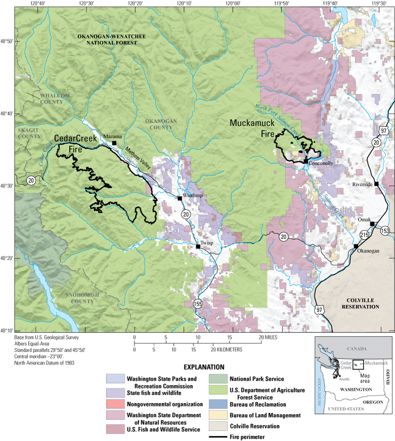
Map showing the fire perimeters of the 2021 Cedar Creek and Muckamuck Fires in and around Okanogan County, Washington. Burned areas included Federal, Tribal, and State lands.
Okanogan County, Washington
Okanogan County in Washington is mostly rural and has about 43,000 residents—a population density of about 8 residents per square mile (Okanogan County, 2023). The county has 6 cities (including Okanogan), 7 towns (including Conconully and Winthrop), 5 census-designated places (including Methow), and several other unincorporated communities (including Mazama). Agriculture and forestry are the county’s two major economic industries, although popular outdoor recreation tourist destinations, such as Methow Valley, also provide economic benefits (Okanogan County, 2023). A Tribal reservation is near the southeast corner of the county, and is about 700,000 acres (Okanogan County, 2023).
The county has a history of major fires and associated postfire effects. In 1894, Conconully had a major postfire flash flood and debris flow (Wilma, 2006). In July 2014, the Carlton Complex Fire burned more than 250,000 acres in Okanogan County, and destroyed more than 300 homes (Ahearn, 2018). Okanogan County sustained cascading postfire hazard consequences after the Carlton Complex Fire, which included floods and mudslides that damaged homes and other infrastructure (King, 2014; Land, 2014).
Cedar Creek Fire
On July 8, 2021, lightning strikes started the Cedar Creek Fire in Methow Valley, Wash.; the fire burned more than 55,500 acres southwest of Winthrop and Mazama (Contreras and Mickelson, 2021a; Forest Service, 2021). Most of the Cedar Creek Fire burn area is managed by the U.S. Department of Agriculture Forest Service (FS; 97.2 percent of the burned area, or 53,718 acres), and smaller amounts of land are managed by the Washington State Department of Natural Resources (WADNR; 1.6 percent of the burned area, or 870 acres) or are privately owned (1.2 percent of the burned area, or 647 acres; Contreras and Mickelson, 2021a).
After the fire, the Washington Geological Survey Wildfire-Associated Landslide Emergency Response Team (WALERT) found 3 debris flows and 2 hyperconcentrated flows in and around the burned area. Two of the debris flows occurred in adjacent drainage basins and deposited sediment in the irrigation ditch that carries water to the southwest side of the Methow Valley. The other debris flow deposited about 14,000 square yards of gravelly sand and woody debris across an agricultural field (Contreras and Mickelson, 2021a).
Modeling indicated low to high debris-flow hazards across the Cedar Creek Fire burned area. The WALERT team built upon the USGS assessment to identify the infrastructure and property at risk from hydrologic hazards, including the State Route 20 corridor, alluvial fans between Mazama and Winthrop, and the Wolf Creek Reclamation District (Contreras and Mickelson, 2021a). The WALERT team suggested that authorities place signs to warn the public of debris flows and flooding in camping areas, and that land managers support irrigation district managers to protect critical infrastructure and notify transportation network managers of the potential issues of blocked culverts, sedimentation, and road erosion (Contreras and Mickelson, 2021a).
Muckamuck Fire
The Muckamuck Fire was similarly ignited by lightning on August 4, 2021, and burned 13,314 acres near Conconully and Conconully Lake, Washington, before reaching 100 percent containment on October 15, 2021. The Muckamuck Fire burned area covered a more diverse land-ownership region as compared with the Cedar Creek Fire. The 13,312 acre burn area is managed by several entities, including the FS (56 percent, or 7,448 acres), private owners (26.3 percent, or 3,510 acres), the Bureau of Land Management (10.2 percent, or 1,366 acres), the WADNR (6 percent, or 796 acres), the Bureau of Reclamation (1.2 percent, or 156 acres), and the U.S. Fish and Wildlife Service (0.3 percent, or 36 acres; Contreras and Mickelson, 2021b).
Regarding hydrologic postfire hazards, the USGS debris-flow assessment models found low to high debris-flow hazards in drainages throughout the Muckamuck Fire burn area (Contreras and Mickelson, 2021b). Drawing from these assessments, WALERT identified several areas where debris flows could affect communities, property, and infrastructure. These areas included recreation cabins and drainage areas around Salmon Creek, one home on an alluvial fan near Mineral Hill Road, the town of Conconully, and alluvial fans along the north shore of Conconully Lake (Contreras and Mickelson, 2021b). The WALERT report (Contreras and Mickelson, 2021b) contains recommendations for landowners and managers to prepare for postfire hazard consequences and notes a need to inform residents of the potential for postfire flash floods and debris-flow hazards if their homes are built on alluvial fans or adjacent to streams flowing from the burn area. The report also recommends signs to warn the public of these hydrologic hazards at camping areas and parking lots. The WALERT team recommends advising transportation network managers and landowners on potential road erosion, blocked culvert issues, and the need to inspect culverts that drain from the burn area because of the increased likelihood of sediment transport during hydrologic events (Contreras and Mickelson, 2021b).
In late July 2022, WALERT geologists identified 3 debris flows, 1 hyperconcentrated flow, and 3 flood events in and around the burn area (Contreras and Mickelson, 2021a). The debris flow and flood waters combined in North Fork Salmon Creek and led to additional flooding downstream in Conconully on July 4, 2022. These hydrologic cascading consequences destroyed one cabin and deposited gravelly sand and woody debris on the town’s roads and against building and bridge foundations. The Governor of Washington requested assistance from the U.S. Army Corps of Engineers after the North Fork Salmon Creek and nearby side channels were clogged with debris and sediment. The U.S. Army Corps of Engineers responded by dredging and building debris-catch structures to increase the channel capacity of North Fork Salmon Creek and build the town’s resilience to future debris-flow events (Contreras and Mickelson, 2021a).
Methods
The Postfire Hazards Chains of Consequences Workshop convened 20 stakeholders who had context- and content-specific knowledge of the 2021 Muckamuck and Cedar Creek Fires and their postfire hazard consequences. This workshop was held virtually for 2 half days on April 24 and 25, 2023. The PHIRE social science researchers used the chains of consequences method for the workshop. The chain of consequences method was developed to identify the potential short- and long-term environmental, social, and economic cascading consequences of crises and determine intervention points. The workshop was facilitated by a team of six USGS scientists on the PHIRE project and in the Social and Economic Analysis Branch. The facilitation team consisted of trained experts from multiple disciplines, including social science, engineering, and hydrology. During each section of the workshop, some of the facilitators led discussions while at least half the facilitators served as notetakers. The workshop was implemented by video conferencing and virtual group management (whiteboard) software. The participants were able to brainstorm virtually using notes, commenting, and other workshop tools. Appendix 1 provides additional details concerning workshop methods beyond what is provided in this section.
In the chains of consequences method, a hypothetical scenario is provided to prompt participants to identify potential consequences and interventions. This scenario is defined through expert consultation with scientists and context-specific stakeholders before the workshop. For example, during the 2018 Kīlauea Eruption Chains of Consequences Workshop (DOI SSG, 2019), participants were provided with scenarios such as seismic and collapse activity at the volcano’s summit. The workshop process included two main steps: (1) developing a detailed chain of consequences that illustrated stakeholders’ informed perspectives of important cascading effects on the coupled natural–human system and (2) identifying potential interventions at points in the scenario at which scientists, policymakers, and other decisionmakers may take specific actions to significantly alter the outcomes of the cascade. These interventions are institutional actions that could support recovery from crisis and increase resilience. A detailed workshop process agenda can be found in appendix 1 (table 1.1).
Stakeholder Identification
Stakeholders were selected based on their expertise related to each of the PHIRE project scientific areas: cultural resources, vegetation recovery, water quality, water quantity, aquatic-habitat quality, sediment transport, and debris flow. Stakeholders also shared their insight into other context-specific groups they recommended be represented, which included local emergency management officials and citizen group representatives.
Selected stakeholders were prioritized to ensure at least one participant represented each combination of scientific focus area and scale of decision making. For example, only one participant may be chosen that has expertise in water-quality concerns at the State level or vegetation-recovery concerns in a specific national forest. Participants were first contacted by email to set up 30-minute, one-on-one conversations that screened for general interest and familiarity with the topics. Formal email invitations were sent to the 20 selected individuals after the one-on-one conversations. If a stakeholder declined workshop invitations, an invitation was extended to another stakeholder who represented the same area of expertise and scale of decision making. Participants were a combination of scientists and local stakeholders that included public works employees, emergency management employees, and individuals representing community groups. The following is a list of the organizations the 20 workshop participants represented:
-
• Bureau of Land Management,
-
• Bureau of Reclamation,
-
• Methow Valley Citizens Council,
-
• National Weather Service (NWS; Spokane Office),
-
• New Mexico Consortium (specifically, individuals with expertise on cultural resources science in the focal area),
-
• Okanogan County,
-
• Okanogan Fire Department,
-
• Okanogan Irrigation District,
-
• Conconully,
-
• Colville National Forest,
-
• FS Timber Program,
-
• Okanogan-Wenatchee National Forest,
-
• USGS Washington Water Science Center,
-
• WADNR Washington Department of Natural Resources,
-
• WADNR Forest Resilience Division, and
-
• Washington Geological Survey.
Scenario Building
Similar to the SSG’s methods, the PHIRE social science research team consulted with scientific experts to identify potential consequences and interventions of the potential hazard scenario (Machlis and McNutt, 2010). The identified scenario (or set of scenarios) reflects the consequences that scientists are concerned about and how consequences interact to shape the overall system in a coupled natural–human systems model (Machlis and McNutt, 2010).
The scenario for the Postfire Hazards Chains of Consequences Workshop was based on consultation with the USGS PHIRE project scientists and their expertise on consequences and the parameters affecting those consequences. Through initial one-on-one meetings, email correspondence, and a large collaborative brainstorming meeting, these scientists from many disciplines shared ideas for scenarios that would capture the wide range of potential consequences of concern in their fields. At the end of the collaborative meeting, the scientists agreed on the broad, yet probable, scenario of a high-intensity rainstorm following a period of drought in north-central Washington. Several scientists also suggested additional layers to this scenario, including a reburn of the 2021 Cedar Creek and Muckamuck Fire burn areas or another future fire burning a different area that affects the same watersheds as the 2021 fires.
The social science team originally planned two scenarios: (1) a high-intensity rainstorm affecting the burn area and (2) a subsequent fire affecting the same watershed and leading to partial reburn of the area. Based on feedback and discussion during the workshop, participants wanted to differentiate between short- and long-term consequences before discussing interventions on day two; therefore, the team adapted the original scenarios to reflect participant interest: (1) a high-intensity rainstorm event and (2) the longer-term (that is, more than 5 years after the rainstorm) consequences of the first scenario. Instead of considering the consequences of another fire in the area (that is, a full or partial reburn in the Muckamuck or Cedar Creek Fire areas), participants were prompted to consider the long-term postfire hazard consequences after the Muckamuck and Cedar Creek Fires (that is, consequences occurring more than 5 years after the initial high-intensity rainstorm scenario).
Identifying Consequences and Interventions
Participants began by brainstorming the first-order or top-level consequences that would begin the consequence chains in the presented scenario. The first-order consequences are broad and might include effects on people and their communities or on soil. Then, participants collectively brainstormed the cascading consequences during a virtual group discussion. Facilitators prompted participants to consider the widest range of possible consequences and the multidisciplinary cascading consequences across different consequence chains. Using the virtual group management software, participants then voted for the 10 consequences that were the most important to brainstorm interventions for. Each participant was given the opportunity to vote for as many as five consequences that they wanted to discuss interventions for. Once the 10 consequences that had the highest number of votes were selected, participants were prompted to brainstorm interventions individually. Participants were provided with definitions of the intervention description, effects, considerations, and two examples that illustrate the intervention identification process before they began (table 1). For each intervention, participants noted its description, effects, and any other considerations.
Table 1.
Guidance on interventions provided to participants for the intervention-identification phase of the 2023 Postfire Hazards Chains of Consequences Workshop in Okanogan County, Washington.Results
Through the workshop process, stakeholders developed detailed consequence chains to demonstrate many consequences and interactions across different chains. Shortly into the brainstorming session, the group agreed to begin brainstorming the cascading consequences chains based on effects on the four first-order consequence categories: people and their communities, soil, vegetation, and hydrology. The participants then identified the consequences cascading from those initial first-order consequences; the complete cascading consequence chains are shown in plate 1 (also available at https://doi.org/10.3133/sir20255036). These resulting consequence chains crossed over and integrated with each other and demonstrated the cascading effects of consequences across disciplines. For example, starting under the “effects on hydrology” first-order consequence, participants identified how a debris flow led to effects on roads and other infrastructure, which decreases water quality, increases erosion, and affects communities (pl. 1).
As a group, participants voted for the 10 consequences they wanted to identify interventions for. In order from most to least votes, participants voted to discuss interventions related to the following consequences:
-
1. Loss of infrastructure and property,
-
2. Loss of life,
-
3. Debris flows,
-
4. Flood prediction challenges,
-
5. Washed-out roads,
-
6. Surface erosion and loss of soil,
-
7. Invasive species,
-
8. Road closures,
-
9. Loss of terrestrial habitat, and
-
10. Loss of trust between communities and Federal agencies.
Participants were also given the option of discussing interventions for other or all consequences (table 2). All identified interventions are listed in table 2 with their corresponding effects and considerations. All the recommendations, potential effects, and considerations in table 2 are opinions that were expressed by workshop participants. These interventions are organized by the corresponding consequences used for brainstorming in the workshop.
Table 2.
Interventions and associated effects and important considerations provided by participants of the 2023 workshop on Postfire Hazards Cascading Consequences in Okanogan County, Washington, in response to the 2021 Cedar Creek and Muckamuck Fires.[To the extent possible, wording provided by workshop participants has been retained verbatim, with the exception of minor additions and modifications made to improve clarity. Interventions are grouped by the consequences they address. NWS, National Weather Service; EAS, Federal Communications Commission Emergency Alert System; NEPA, National Environmental Policy Act; BAER, Burned Area Emergency Response; NRCS, Natural Resources Conservation Service; USGS, U.S. Geological Survey; FEMA, Federal Emergency Management Agency]
| Interventions | Effects | Considerations |
|---|---|---|
| Remove or improve troublesome (that is, impaired or inappropriately designed) culverts | Reduces potential for blockage of streams that might result in debris flows or roadway erosion | Access and funding may be challenging |
| Install beaver dam analogs and other instream features | Reduces stream velocity and sediment transport | Requires permitting and landowner buy-in and coordination; Effective and inexpensive |
| Transportation-system reconstruction and maintenance before the fire | Reduces potential for road washouts | Should involve properly functioning ditches and culverts free of debris before fires; Some crossings may need to have surfaces reinforced and debris catches added |
| Acquisition of public land on alluvial fans and floodplains for public green spaces | Decreases loss of life and infrastructure following hazards; Restores natural processes that are important for ecosystems | Costly; Often impractical |
| Fuel reduction and forest-health treatments before the fire at a landscape-scale | Reduces potential for blockage of streams that might result in debris flows or erosion of roadway | Access and funding may be challenging |
| Revisit and update underlying planning and zoning regulations to prevent location of homes and infrastructure in danger zones | Prevents building or location of critical infrastructure in danger zones | Property rights concerns create challenges |
| Work with insurance industry to incentivize relocation instead of rebuilding in danger zones | Gradually reduces the number of homes and infrastructure located in dangerous alluvial areas and floodplains | Must involve insurance industry |
| Use social or mass media to notify the public of increased risk to life | Public is informed of increased risk | Needs to reissue notification prior to predicted events; A lot of information exists so getting specific information out to residents and potentially affected people is important; Challenges with access and service limitations |
| Improve ability to predict storms that will produce heavy precipitation (for example, better radar, well-placed rain gages) | Allows earlier preparation and evacuation funding along with agency requests when tied with early warning systems | Intervenes in consequences related to flood risk predictions; This is the job of the NWS, yet not all workshop participants were aware of this ongoing work; Requires data gathering for forecasting improvements required, and observations and real-time data |
| Acquisition of public land on alluvial fans and floodplains for public green spaces | Decreases loss of life and infrastructure following hazards; Restores natural processes that are important for ecosystems | Costly; Often impractical |
| Increase signage in areas susceptible to flash flooding and debris flows | Increases local and visitor awareness | Could be included at campgrounds and local lodging areas |
| Increase and improve the alert warning system | Promotes better understanding of how and when hazard warnings are issued; Reaches more people when necessary; Improves rainfall and hazard predictions | Limited to areas with cell coverage; Needs to consider the Federal Communications Commission Emergency Alert System (EAS); Challenges with getting information out quickly; Requires data gathering for forecasting improvements, observations, and real-time data; Requires more rain gages and improved radar |
| Monitor weather and precipitation at the local level to improve warnings and alerts for debris flows and flooding | Improves accuracy of warning and alerts for hazards; May improve the public’s trust in those areas | Requires data gathering for forecasting improvements and observations and real-time data |
| Educate the public about debris flow and flooding hazards following fires | Helps people better understand risks and preparedness | Debris flows can be scary and complicated; People may tune out or turn away if not educated appropriately |
| Increase and improve the alert warning system | Promotes better understanding of EAS criteria; Reaches more people when necessary; Improves rainfall and hazard predictions | Limited to areas with cell coverage; Needs to consider National Weather Radio Alert coverage and Emergency Management notification systems; Challenges with getting information out quickly; Requires data gathering for forecasting improvements and observations and real-time data; Requires more rain gages and improved radar |
| Identify areas at risk to these hazards prior to rain events and have an emergency response plan in place to deal with them | May reduce negative effects and uncertainties when dealing with debris-flow hazards | Should be done in close coordination with local communities |
| Install beaver dam analogs and other instream features | Reduces stream velocity and sediment transport | Requires permitting and landowner buy-in and coordination; Effective and inexpensive |
| Have alert system in place that everyone can use and is not too technical | Gets information to all people in the affected area plus Emergency Management in a timely manner | Needs to place gages in the appropriate places to be able to predict what is important for saving life and property |
| Vacate area while natural recovery occurs | Allows natural systems to heal independently | Infeasible in some locations, including State highways and vital roadways; Economic impacts; Changes historical uses |
| Identify areas appropriate for debris-flow-mitigation structures around vulnerable communities or infrastructure | Mitigates high-risk areas to reduce public safety concerns | Expensive and needs to consider ownership concerns or downstream effects |
| Maintain road system and invest in designing and building appropriate crossings | Promotes a resistant and resilient road system | Would include removing roads from the transportation system if the area’s risks outweigh the need for the roads; Could include putting some roads into storage and pulling culverts; Could include using bridges and hardened crossings with debris catches on some crossings; Could include looking for opportunities to mitigate hazards directly (for example, debris-flow diversions) |
| Increase alert rain gages across areas under threat from flash flooding and debris flows | Increases the rainfall measurements and threshold criteria; improves warning program | Being mobile with changing conditions |
| Improve ability to predict storms that will produce heavy precipitation (for example, better radar, well-placed gages) | Improves hazard alert effectiveness; Allows for better preparation or evacuation funding and agency requests | Requires more rain gages or radar data |
| Increase flood forecast points for susceptible streams and rivers | Increases notification on water rises | May be focused more on wider precipitation events rather than localized areas |
| Increase streamgage network | Provides a record of historical changes with various types of rainfall events that can be used in context to understand the effects of wildfire runoff response | Hydrologic impacts of wildfire are difficult to quantify without historical flow data |
| Engineer wetlands or other areas that can store excess water (for example, ponds) | Decreases future flashiness of some streams; Lowers flooding severity | Serves as a preventative measure |
| Increase public reports of heavy rain and flooding through volunteer citizen science programs | Increases the network of reporting rainfall | May lack coverage in rural or remote areas |
| Improve radar capabilities for the east side of the Cascade Range | Improves ability to predict the location of problematic storm cells; Allows earlier evacuation and preparation | Requires agency action, funding, and might cover a larger geographic range than the east side of the Cascade Range (for example, eastern Oregon and Washington) |
| Design crossing repair (or transportation system) considering the hydrologic disturbance regime | Reduces damage from future events; Maintains access | The bigger the repair required, the more likely that environmental groups will be involved in and potentially oppose the intervention; Needs to complete NEPA reporting as soon as possible; Needs to prioritize to ensure scope; Road reroute is an alternative that needs to be considered |
| Inventory the problem areas where washouts are likely to occur | Focuses approach to working where it is needed the most before an event happens | Requires funding and engineering; Requires overcoming the thought of leaving something in place until it is damaged or destroyed and then repairing it |
| Upsize crossings before events occur | Enables crossings to accommodate higher flows | Cost of larger culverts; Changes to standard practices |
| Improve water drainage features on roads | Casts runoff into forest water systems potentially altering natural water flow patterns | Minor costs; Requires landowner collaboration |
| Experiment with soil-stabilizer spray and other applications | Low-cost way to stabilize slopes in drier environments | Needs to figure out exactly what this intervention entails; The amount needed to have an effect is expensive; Soil-stabilizer sprays and chemicals are potentially made of tree lignin |
| Relocate stream-adjacent parallel roads | Reduces potential for flash floods affecting roads | Expensive and requires permitting; May not be feasible in certain drainages |
| Grass and shrub seeding | Reduces surface erosion and loss of soil | There is a need to ensure proper seed mixes; Seed collection and seeds are expensive; Figuring out the appropriate seed mixes can be challenging and depends on the ecosystem; Invasive species can invade the mixes; Predation by birds and insects is a challenge |
| Fuel reduction and forest-health treatments before the fires | Reduces soil burn severity | Requires planning and long-term investment |
| Target erosion mitigation (for example, hay bale barriers) | Reduces surface erosion and movement or destabilization of sites | Inexpensive; Requires specialist consultation |
| Mulching burn areas | Slows surface runoff and decreases erosion | There is mixed research on the effectiveness of mulching burn areas, including straw-bale mulching; The mulch often washes away in high-intensity rainfall that is likely to trigger floods and debris flows; Helicopter application is expensive; To work correctly, mulch must be placed at the appropriate areas, in the appropriate concentrations, and within certain time windows post-fire |
| Grass and shrub seeding | Establishes favorable species and increases competition | Inexpensive but requires appropriate seed mixes; May be the most appropriate intervention for consequences related to invasive species |
| Herbicide treatment | Eradicates some invasive plant species | Requires a coordinated approach across ownership; Needs to establish favorable species |
| Fuel reduction and forest-health treatments before the fire | Reduces vegetation and soil-burn severity | Needs to clean equipment and pretreatment and posttreatment weed treatments when implementing thinning/fuel reduction; Effective tool but, in the long term, one that is hard to implement; Everyone would likely agree this is wanted, but the considerations are big |
| Mulching burn areas to reduce sedimentation of streams and mitigate losses in reduced reservoir capacity | Slows surface runoff and decreases erosion | There is mixed research on the effectiveness of mulching burn areas, including straw-bale mulching; The mulch often washes away in high-intensity rainfall that is likely to trigger floods and debris flows; Helicopter application is expensive; To work correctly, mulch must be placed at the appropriate areas and in the appropriate concentrations |
| Assess need for road based on a rapid transportation analysis; Repair and open road using emergency authority if possible | Minimizes closure duration | Needs to consult line officer and engineers; Needs to consider Emergency Medical Services and Fire and Fuels; Requires assessment of impacts to health and safety; Must consider how fire suppression and other activities will be affected |
| Inventory and identify alternate access routes or detours at neighborhood, community, and watershed scales | Provides alternate access during and after emergency events | Okanogan Council of Governments conducted a Primitive Road Study (SCJ Alliance, 2021) that could serve as a starting point; Some roads have been closed but could be opened on an emergency basis; Needs to implement detours and traffic diversions before rain occurs; In some areas, there is not an alternative route or no public roads (forest roads, timberlands, and so forth); May need to involve developing working relationships with timber companies and others in case of emergencies. |
| Collaboration with weather service and local or State entities who manage road systems before and during rain events | Identifies opportunities to concentrate resources to deal with events and preemptively close roads to avoid potential loss of life | Economic impacts of closing roads |
| Institute a mapping system and data collection for road maintenance tracking after floods and debris flows | Quantifies the costs of the microdisasters and helps people get reimbursed for them | Needs to be simple and easy to use |
| Improve road crossings in hazard-prone areas | Increases ability to accommodate higher flows, flash floods, and possibly debris flows | Can be implemented in a way that increases fish passage |
| Look for opportunities to relocate stream-adjacent parallel road segments | Removes the road sediments from flood-prone areas | Expensive; Requires permits and landowner cooperation |
| Collect seeds before the fire | Captures genetics | Needs to consider if there is infrastructure to collect seeds |
| Increase active management to prevent large-scale loss of terrestrial ecosystems | Treats more acres; Reduces potential extreme losses to habitats; Improves forest health; Long-term sustainability of terrestrial ecosystems on the landscape | Planning can be a long process; Multiagency/cross-boundary work needs to be considered; Emphasis on “thinning from below”; Retention of larger trees, mature root systems, clumps of trees |
| Reseeding and planting in consultation with Tribal partners to maintain access to culturally important plants | Increases access to traditionally important food and other resources; Increases landscape aesthetics; Solidifies partnerships with Tribal stakeholders | Consultation process can be lengthy; Could include programmatic agreements; Requires government-to-government consultation |
| Vegetation treatments like thinning and reducing fuel in stream areas and broader landscapes before the fire | Reduces fire severity | Access issues make stream treatments infeasible for many areas within a watershed |
| Provide more public in-person meetings to the at-risk residents to share resources and information | Fosters face-to-face interaction between the public, emergency managers, county leadership, and scientists; Builds trust and increases understanding of the information available and work being done to help the public | Needs to be planned during evenings or weekends to increase turnout; These interactions should be annual or otherwise recurring throughout the period of heightened hazards to communicate what has been happening in the area, and the evolution of associated risk to the communities |
| Create and maintain a fire-specific website, toolkit, or dashboard where people can go to learn about post-fire hazards | Creates one place or toolkit for interested people to access information about their community and fire area and see the work that is being done to help | Should include information on events that occur in their fire area, alerts and warning systems, and monitoring; Could include reference links in a toolkit |
| Increase and improve the alert warning system | Increases understanding of Watch and Warning criteria; Reaches more people when necessary; Improves rainfall and hazard prediction | Limited to areas with cell coverage; National Weather Radio Alert coverage and Emergency Management notification systems need to be considered; Getting information out in advance quickly is challenging; Requires data gathering for forecasting improvements and observations and real-time data; Requires increased rain gages and improved radar |
| Hold Federal and State agencies accountable to promises they have made to communities | Builds trusts when agencies follow through on prior commitments; Incentivizes Federal agencies not to make promises they cannot keep | Administrative burdens make this difficult |
| Identify values at risk before a fire in an integrated process that includes communities and key stakeholders and then include these values in objectives for projects and incident management | Public sees ongoing effort to manage risks based on their values | This is a long-term, integrated approach |
| Property manager and neighborhood assistance with preparation for catastrophic events | People learn to self-organize in ways that are most helpful to themselves and emergency personnel; Builds trust by involving the public in the solutions early | There are models for how to organize community and emergency service professionals(for example, Fire-Adapted Communities [https://fireadapted.org/], conservation districts, and State departments of natural resources cost-share programs [https://www.dnr.wa.gov/cost-share]). |
| Look at potential improvements to the BAER assessment process on State, Federal, and private land following large wildfires. Integrate with other assessment processes (for example, the NRCS) to improve information flow and funding available for mitigation | Improves efficiency and effectiveness across agency programs; Improves access to real-time information about at-risk areas to focus efforts | Requires coordination with BAER teams and other emergency response teams, scientists, and local governments involved in assessment processes, information flow, and mitigation funding |
| To intervene in reduced water quality: Install water quality sensors with real-time transmission | Monitors water quality for public alerts and better understands potential effects to surface water | Must be maintained at a high standard to provide reliable accuracy, which can be expensive |
| Add to the State-level funding of rain gages to see USGS work with the water science centers to fund installations of rain gages and streamgages after fires and potentially find an opportunity to put aside funding to do that | Produces high-quality data to inform NWS and USGS research | Was done successfully in New Mexico; Has also been done in Washington with NRCS funding; Relatively straightforward; Could involve mission assignments and FEMA |
Discussion
Throughout the workshop, participants discussed their individual experiences with, and scientific expertise related to, postfire hazards in Okanogan County, Wash. Particularly, participants discussed the cascading consequences of the debris flows on July 4, 2022, at the Muckamuck Fire burn area. They explained many challenges, including creek turbidity, vegetation recovery, sedimentation in reservoirs, recreational fishing, road closures, access issues for first responders, and tourism. Participants also asked each other for insight on the postfire hazard consequences they were already facing. For example, one participant shared his experience with one local creek “running dirty, like chocolate milk,” and asked for scientific insight from other participants to understand how long they could expect this turbidity and sedimentation to last. Overall, the lived experiences and scientific expertise held by workshop participants led to a discussion that spanned the entirety of the PHIRE burn areas.
When focusing on interventions, participants discussed the literal and figurative downstream effects of their ideas. Through the discussion, they identified institutional actions at multiple levels of decision making, suggested improvements to monitoring and outreach, and elaborated on other considerations (for example, permitting requirements) and unintended consequences (for example, increased debris in potential future debris flows as an unintended consequence of mulching).
Applying the Chains of Consequences Method to the Postfire Hazard Context
Applying the chains of consequences method had short-term and potentially long-term effects on participants and their organizations by facilitating cross-boundary connections. This type of cross-boundary collaboration has been supported by conservation and environmental science literature because of the complex nature of environmental and social problems (Perz and others, 2010).
How participants chose to structure the consequence chains reflected their various disciplinary perspectives. At the beginning of the workshop, participants structured the consequence chains in an unexpected way. Based on previous chains of consequences workshop results, the workshop facilitators expected the participants to structure the chains using first-order consequences that reflected specific physical outcomes of the scenario that then precipitate into a series of consequences. However, the workshop participants decided to instead organize around effect categories, which still led to a rich discussion of the many consequences of the scenario and how the consequences in one category led to cascading chains across other categories. This decision demonstrates the flexibility of this workshop method to meet the needs and perspectives of stakeholder groups while still eliciting information of interest.
The PHIRE workshop applied the chain of consequence method to longer-term scenarios specific to postfire hazard consequences and intervention planning. Although this application differs from prior SSG efforts (DOI SSG, 2013, 20196; Hopkins and others, 2018), participants emphasized the value of discussing complex postfire hazard consequences and interventions during the workshop. When asked for feedback at the end of the workshop, one participant said that the workshop “increased [the participant’s] understanding with areas outside [the participant’s] expertise.” Other participants shared that the workshop was a “great way to interact with different agencies [and] disciplines” and that the “idea sharing was great.”
Mapping Cascading Consequences
Participants focused on and began discussing the first-order consequence categories—effects on the area’s community, hydrology, vegetation, and soil, which they defined through discussion as “fundamental issues for postfire.” Participants went on to brainstorm how the cascading consequences included multiple disciplines. This shift indicates the inherent interdisciplinary nature of these consequences and the stakeholders’ awareness of this interdisciplinarity.
In the consequence chains and discussion, participants focused primarily on human and community effects like personal safety and transportation access issues. Participants considered loss of life a potential cascading consequence of hydrologic events, specifically debris flow and flooding. They were also concerned with the loss of roads and other transportation issues caused by these hydrologic events. This focus on safety and related concerns is perhaps notable given that stakeholders were selected because of their interests and expertise in a variety of fields, including vegetation recovery, water quality, and cultural resources. These selections suggest that an emphasis on the prioritization of human life and safety concerns is deeply ingrained in the perspectives of professionals working in many disciplines associated with postfire hazards. This may also be because most participants live near or have other personal ties to the Okanogan County area.
When discussing community effects, a participant explained how agencies “did a great job communicating risk” around the July 4, 2022, debris-flow event, which provided communities with adequate warning ahead of time. Yet, despite this warning, some stakeholders explained the challenges of hazard mitigation with limited funds. They also emphasized the long-term mental health effects of these fires and postfire hazards, including the stress communities and individual residents face because they know what happened during the previous debris flows, and many others live in alluvial fans below the fire burn areas. For example, one participant explained that they have “whole communities and individual residences that, for the next ten years or more, as soon as they get raindrops on their house, their anxiety goes up because they know what happens upstream of them.” In other words, participants were concerned about the increased anxiety during every rainstorm following the fires since the July 4, 2022, debris flow.
In this discussion, participants also emphasized the potential loss of trust communities have in science information and the people who communicate the information as major problems. Participants also asserted that agencies must adapt to address these trust issues. Workshop participants tasked with issuing warnings also explained how they often grapple with informing the public while also ensuring communities do not tune out the warnings if they receive too many. Participants agreed that the main necessity to reduce loss of life and improve warning systems was more observational data. For example, items like rain gages could capture real-time data, which would give the communities specific information about how debris flows could affect them personally.
Using the consequence chains, participants demonstrated how vegetation and soil effects were considerably intertwined. They discussed seeds having difficulty establishing when there is no soil for them to grow in. Discussion also included the effects established vegetation has on stabilizing soil and reducing erosion. On the consequence chains, participants detailed how the loss of terrestrial habitat could cascade into effects on culturally important plant species and the loss of winter habitat for key game species. This loss could lead to reduced hunting opportunities (and revenue loss from fewer hunters), high costs from replanting key vegetation species, and diminished returns from traditional foods like Vaccinium L. (huckleberries).
Participants noted how debris flow cascaded into changes in (1) channel morphology, (2) channel scour, (3) stream confinement, and (4) loss of habitat connectivity. Debris flow also cascaded into a chain of consequences, including loss of life and blocking bridges and culverts, which could pond water, trigger more debris flows, and eventually cause flooding of roadways. Participants representing the town of Conconully and participants representing Okanogan County elaborated on the community effects of debris flow, specifically how irrigation systems and infrastructure have been affected since their July 4, 2022, debris flow.
Considering Interventions
The 10 consequences participants selected to identify interventions for focused primarily on human or community effects. Some participants were more concerned than others and made statements like, “I think we don’t do things soon enough to protect life and property that could be done.” Other participants expressed the opposite concern, and one participant explained that they “were struggling to connect to the consequence” because “loss of life from debris flow isn’t really something they hear about a lot.” Most participants discussed interventions for these human effects to limit the loss of life, damage to infrastructure, and impaired road access. Participants emphasized the need for longer-term (20 or more years) zoning and planning and fuel management, like prescribed burning, to effectively reduce loss of life, infrastructure, and property.
One participant emphasized the work that the NWS does to monitor weather, predict storms, and report hazards to communities (NWS, 2024). Discussing the NWS work started a larger discussion about the desire for increased streamgages and methods of getting information out to remote communities without cellular service. Rain gages were a primary concern among workshop participants. One participant stated that they “want to reiterate, getting more observation data is key,” elaborating, “Specifically, rain gages would be a feasible option to get more real-time data and so the public can see and use that on a personal level, so they can make the decisions they need to in the case of an emergency developing.” Another participant added to the discussion by suggesting, “I think it would be great to see, in addition to the State-level funding of rain gages, USGS work with the water science centers to fund [the] installation of rain gages and streamgages after fires and potentially [find an] opportunity to put aside funding to do that . . . [that was done] with great success in New Mexico and in the past it has been done in Washington with Natural Resources Conservation Service funding. Mission assignments and [the] Federal Emergency Management Agency can get involved as well. It is a quick way to get high-quality data to inform NWS and USGS research.”
When discussing the challenges of warning communities, one participant explained, “Getting the information out to the audience is web based these days and so many of the areas that we serve are off-grid and don’t have access to the internet. That’s one of the biggest challenges.” For remote communities, it is critical to have appropriate warning systems and communication to alert residents about impending hazards in advance.
To intervene in the consequence of washed-out roads, participants discussed the feasibility of soil stabilizers and designing future transportation systems that consider hydrological systems. One participant emphasized, “It's about scoping when it comes to feasibility. It’s spending your money where it matters. Scoping and focusing in on the areas through design and some kind of decision-maker working together.” Although disasters, such as fires and postfire hazards, offer potential opportunities for policy change to improve land-use planning and mitigation, studies have not found evidence of sufficient reinvestment in hazard-prone environments with government support after wildfires (Mockrin and others, 2016; Kramer and others, 2021).
To intervene in debris-flow hazards, participants suggested the installation of beaver dam analogs and other instream features. Other participants noted that this intervention is challenging because it involves intentionally adding debris to a stream, which potentially increases liability for downstream harm (such as modifying river flow and water availability). Several participants also discussed how vacating areas while natural recovery occurs could make hazards less disastrous. However, this option is not often possible because State highways and vital roadways often need to stay open, which requires repairs. They also suggested identifying areas at risk of hazards before rain events and establishing emergency response plans as quickly as possible.
Participants discussed other unintended consequences of potential interventions. For example, after suggesting mulching and chipping in burn areas as an easy and low-cost intervention to reduce loss of infrastructure and property, several participants explained how mulching can have unintended consequences when heavy rainfall washes it off and plugs culverts. Although this intervention helps reduce erosion by dispersing water droplets from rainfall, mulching could potentially contribute to more debris flows during extreme rainfall.
Reflecting on the Use and Applicability of U.S. Geological Survey Resources
Many reports discuss the need for advanced tools, information, and assessments to support postfire hazard decision making (for example, Federal Geographic Data Committee, 2019; Ekarius and others, 2020; Wildland Fire Mitigation and Management Commission, 2023). The Wildland Fire Leadership Council emphasizes the need for scientists to work with Federal, State, local, Tribal, and nongovernmental groups to jointly define the data and tool requirements and the strategic information needed for decision making (Wildland Fire Leadership Council, 2023).
The USGS has diverse capabilities across scientific disciplines and provides scientific data, tools, and resources to support postfire-hazard decision making. For example, the USGS can characterize burn severity by studying biomass consumed below and aboveground before and after a fire. Studying biomass is critical for postfire debris-flow and vegetation-trajectory likelihood assessments and Burn Area Emergency Response (BAER) plans postfire (Eidenshink and others, 2007). The USGS Landslide Hazard Program draws from this characterization of burn severity to assess and monitor postfire debris-flow risk. State water science centers also conduct postfire water-quantity and -quality monitoring and risk assessments for flooding, sedimentation, contaminants, and potential mitigation opportunities (USGS, 2023). This work involves deploying temporary water gages, sampling water quality, and advising on postfire mitigation options from a hydrology perspective (USGS, 2018). The USGS also provides geospatial and remote-sensing data through the National Geospatial Program (https://www.usgs.gov/programs/national-geospatial-program), National Land Imaging Program (https://www.usgs.gov/programs/national-land-imaging-program), and Earth Resources Observation and Science Center (https://www.usgs.gov/earth-resources-observation-and-science-eros-center). Data are also available at the interagency collaborative resource LANDFIRE-Landscape Fire and Resource Management Planning website (https://www.usgs.gov/mission-areas/core-science-systems/science/landfire-landscape-fire-and-resource-management-planning#overview). Specifically, LANDFIRE supports efforts to determine change in wildland fire risk by remapping remaining fuels (LANDFIRE, 2023). Researchers at the USGS also advise Burned Area Emergency Response teams on re-establishing desirable plant species and cover while minimizing fire-adapted invasive species postfire.
Throughout the Postfire Hazards Chains of Consequences Workshop, participants discussed available USGS resources for their postfire hazard decision making. Participants emphasized the tools, information, and assessments still needed to support their understanding of, and preparedness for, the cascading consequences of postfire hazards. For example, many participants discussed how the USGS Landslide Hazards Program Emergency Assessments of Postfire Debris Flow Hazards maps inform their postfire hazard decision making (https://usgs.maps.arcgis.com/apps/dashboards/c09fa874362e48a9afe79432f2efe6fe). After a fire, the USGS Landslide Hazards Program develops an Emergency Assessment of Postfire Debris-Flow Hazards. The Postfire Debris-Flow Hazards maps show the response of potential mountain front debris flow likelihood and volume after a simulated storm, but they do not identify or assess runout paths, inundation areas, or potential damage (https://www.usgs.gov/programs/landslide-hazards/science/emergency-assessment-post-fire-debris-flow-hazards). The NWS bases debris flow warnings and watches on these assessments. The Washington Geological Survey WALERT builds off the USGS debris-flow assessments to evaluate potential risk posed by landslides and debris flows (WADNR, 2023).
Adding to the discussion on rain gages (refer to the “Considering Interventions" section), participants also expressed the need for more models based on data specific to their region in Washington. Without accurate models for Washington, there is uncertainty about rainfall thresholds triggering debris flows and how long the debris-flow hazard exists.
Summary
As with any study, this report has limitations. The findings in this study reflect the beliefs of the stakeholders included in the workshop and the extent of information that could be shared and documented during the workshop, given time and resource restrictions. Postfire Hazards Chains of Consequences Workshop facilitators identified lessons learned about workshop preparation, implementation, and results interpretation. Participants expressed that the most challenging part of the workshop was identifying first-order consequences because this part generally involves participants reaching consensus. In the Postfire Hazards Chains of Consequences Workshop, participants identified categories of consequences (for example, hydrologic effects and vegetation effects) rather than first-order consequences. In future postfire hazards workshops, instead of having participants identify these first-order consequences, the workshop facilitators could consult with experts to identify the starting point to frame the discussion; participants could then be given the opportunity to expand on or modify the first-order categories for consequences. Facilitators could also consider providing participants with the scenario in the form of a consequence chain that the participants can then expand from.
If time permits, the workshop could also include dedicated discussion time when the virtual or inperson whiteboard is closed or inaccessible. During the Postfire Hazards Chains of Consequences Workshop, participants focused on brainstorming on the board and did not interact with each other as much as anticipated. This may be particularly important to consider in virtual workshops, when participants are not moving between their chairs and a whiteboard, to distinguish between brainstorming and discussion time.
Adding a break in the workshop after participants vote for the most important consequences to discuss interventions for may be beneficial because it could give facilitators a chance to tally and discuss the votes for the consequences participants want to discuss interventions for. When asked for feedback on the workshop, one participant suggested that the facilitators should have indepth knowledge of the hazards and scenario(s) to help guide discussions. Participants of the Washington Postfire Hazards Chains of Consequences Workshop also shared their insight on several stakeholders they believed would be critical in future workshops. These stakeholders included representatives from neighboring Tribes, the U.S. Department of Transportation, utility providers, the U.S. Department of Energy, and the U.S. Fish and Wildlife Service.
The Postfire Hazards Chains of Consequences Workshop was designed to bring together stakeholders with content- and context-specific knowledge related to postfire hazards around Okanogan County, Washington. Over 2 half days in April 2023, U.S. Geological Survey facilitators convened these stakeholders and used the chains of consequences method. The chain of consequences method in the postfire hazard context allowed participants to identify the cascading consequences and interventions of postfire hazards across disciplines. The application of this method in the wildfire context may be useful for future adaption of the chain of consequences method in other natural resource-related decision-making contexts. It also had short-term benefits and effects on participants, including improved interorganizational communication and opportunities to identify gaps in understanding postfire hazards and their consequences.
This report presents the first application of the chain of consequences method to a postfire hazard context. Stakeholders were presented with a specific postfire hazard scenario: a high-intensity rainstorm following several years of prolonged drought near the 2021 Cedar Creek Fire and Muckamuck Fire burned areas. Stakeholders then identified the cascading consequences of this scenario, spanned across four first-tier categories—effects on people and their communities, soil, vegetation, and hydrology. Participants were encouraged to brainstorm the various potential consequences that cascaded across disciplinary boundaries. Then, participants voted on 10 identified consequences that they wanted to discuss potential interventions for; participants mostly focused on reducing loss of life and infrastructure.
Participants emphasized the value of creating interdisciplinary connections during the workshop, and these connections provided valuable information on postfire hazard concerns and resources. The chains of consequences method provided a flexible framework that allowed participants to connect, identify gaps in their understanding of consequences, and develop prioritized postfire hazard interventions. Several participants noted that they would continue the conversations they started in the workshop. During the workshop, the participants used their newly formed connections and asked each other for advice and insight on a range of multidisciplinary postfire hazard consequences and interventions. Moreover, the workshop provided agencies with information on stakeholder postfire hazard concerns and ways that tools and resources can be improved or expanded to better meet stakeholder needs.
References Cited
Ahearn, A., 2018, Four years after Carlton Complex devastated Okanogan County, what have we learned?: Northwest Public Broadcasting, August 17, 2018, accessed April 2023 at https://www.nwpb.org/2018/08/17/four-years-after-carlton-complex-devastated-okanogan-county-what-have-we-learned-about-homes/.
Cannon, S.H., Gartner, J.E., Wilson, R.C., Bowers, J.C., and Laber, J.L., 2008, Storm rainfall conditions for floods and debris flows from recently burned areas in southwestern Colorado and southern California: Geomorphology, v. 96, no. 3–4, p. 250–269, accessed April 2023 at https://doi.org/10.1016/j.geomorph.2007.03.019.
Contreras, T., and Mickelson, K., 2021a, Wildfire-associated landslide emergency response team report—Cedar Creek and Cub Creek 2 Fires, Okanogan County, Washington: Washington State Department of Natural Resources, Washington Geological Survey, 14 p., accessed April 2023 at https://www.dnr.wa.gov/publications/ger_hazards_landslide_walert_report_cedar_cub_2021.pdf.
Contreras, T., and Mickelson, K., 2021b, Wildfire-associated landslide emergency response team report—Muckamuck Fire, Okanogan County, Washington: Washington Department of Natural Resources, Washington Geological Survey, 7 p., accessed April 2023 at https://www.dnr.wa.gov/publications/ger_hazards_landslide_walert_report_muckamuck_2021.pdf.
Department of the Interior Strategic Sciences Group [DOI SSG], 2013, Operational Group Sandy technical progress report: Washington, D.C., U.S. Department of the Interior, 75 p., accessed April 2023 at https://coastal.er.usgs.gov/hurricanes/sandy/sandy_tech_122413.pdf.
Department of the Interior Strategic Sciences Group [DOI SSG], 2019, Results from the Department of the Interior Strategic Sciences Group technical support for the 2018 Kīlauea Eruption: Washington, D.C., U.S. Department of the Interior, 56 p., accessed April 2023 at https://edit.doi.gov/sites/doi.gov/files/uploads/ssg-kilauea-cooperator-report-508.pdf.
Eidenshink, J., Schwind, B., Brewer, K., Zhu, Z.-L., Quayle, B., and Howard, S., 2007, A project for monitoring trends in burn severity: Fire Ecology, v. 3, no. 1, p. 3–21, accessed April 2023 at https://www.mtbs.gov/sites/mtbs/files/inline-files/Eidenshink-final.pdf. [Also available at https://doi.org/10.4996/fireecology.0301003.]
Ekarius, C., Rowden, K., Oakley, N., Lancaster, J., Zupko, M., Timmons, T., and Bradley, A., 2020, Post-fire science needs for emergency response hazards and rehabilitation, After the Flames Science Session, May 19–20, 2020, Two-day virtual science symposium report: Coalitions & Collaboratives, Inc., 9 p., accessed April 2023 at https://aftertheflames.com/wp-content/uploads/2020/08/Final-Science-Report.pdf.
Federal Geographic Data Committee, 2019, 2018 annual report: Reston, Va., Federal Geographic Data Committee, 40 p., accessed April 2023 at https://www.fgdc.gov/resources/whitepapers-reports/annual%20reports/2018/2018fgdc-ar-lr.pdf.
Forest Service, 2021, Cedar Creek/Cub Creek 2/Delancy Fires update: Okanogan-Wenatchee National Forest web page, accessed April 2023 at https://www.fs.usda.gov/detail/okawen/news-events/?cid=FSEPRD931293.
Hopkins, M.C., Adams, M.J, Super, P.E., Olson, D.H., Hickman, C.R., English, P., Sprague, L., Maska, I.B., Pennaz, A.B., and Ludwig, K.A., 2018, Batrachochytrium salamandrivorans (Bsal) in Appalachia—Using scenario building to proactively prepare for a wildlife disease outbreak caused by an invasive amphibian chytrid fungus: U.S. Geological Survey Open-File Report 2018–1150, 31 p., accessed April 2023 at https://doi.org/10.3133/ofr20181150.
Johansen, M.P., Hakonson, T.E., and Breshears, D.D., 2001, Post-fire runoff and erosion from rainfall simulation—Contrasting forests with shrublands and grasslands: Hydrological Processes, v. 15, no. 15 (special issue), p. 2953–2965, accessed April 2023 at https://doi.org/10.1002/hyp.384.
Kean, J.W., Staley, D.M., and Cannon, S.H., 2011, In situ measurements of post-fire debris flows in southern California—Comparisons of the timing and magnitude of 24 debris-flow events with rainfall and soil moisture conditions: Journal of Geophysical Research, v. 116, no. F4, article F04019, 21 p., accessed April 2023 at https://doi.org/10.1029/2011JF002005.
King, A., 2014, Twisp digs out from flash flooding after Carlton Complex Fires: Northwest News Network, August 24, 2014, accessed April 2023 at https://www.nwnewsnetwork.org/disasters-and-accidents/2014-08-24/twisp-digs-out-from-flash-flooding-after-carlton-complex-fires.
Kramer, H.A., Butsic, V., Mockrin, M.H., Ramirez-Reyes, C., Alexandre, P.M., and Radeloff, V.C., 2021, Post-wildfire rebuilding and new development in California indicates minimal adaptation to fire risk: Land Use Policy, v. 107, article 105502, 8 p., accessed September 3, 2024, at https://doi.org/10.1016/j.landusepol.2021.105502.
Land, T., 2014, Mudslides wash away roads at Carlton Complex fire site: KGW8, August 23, 2014, accessed April 2023 at https://www.kgw.com/article/news/local/washington/mudslides-wash-away-roads-at-carlton-complex-fire-site/283-71346876.
LANDFIRE, [2023], About LANDFIRE: LANDFIRE web page, accessed April, 2023, at https://www.landfire.gov/about.php.
Machlis, G.E., and McNutt, M.K., 2010, Scenario-building for the Deepwater Horizon Oil Spill: Science, v. 329, no. 5995, p. 1018–1019, accessed April 2023 at https://doi.org/10.1126/science.1195382.
Meadow, A.M., Ferguson, D.B., Guido, Z., Horangic, A., Owen, G., and Wall, T., 2015, Moving toward the deliberate coproduction of climate science knowledge: Weather, Climate, and Society, v. 7, no. 2, p. 179–191, accessed April 2023 at https://doi.org/10.1175/WCAS-D-14-00050.1.
Mockrin, M.H., Stewart, S.I., Radeloff, V.C., and Hammer, R.B., 2016, Recovery and adaptation after wildfire on the Colorado Front Range (2010–12): International Journal of Wildland Fire, v. 25, no. 11, p. 1144–1155, accessed April 2023 at https://doi.org/10.1071/WF16020.
National Weather Service [NWS], [2024], Hazards and warnings: National Weather Service web page, accessed September 3, 2024, at https://www.weather.gov/gjt/hazards_warnings.
Okanogan County, 2023, About us: Okanogan County, Washington web page, accessed April 2023 at https://www.okanogancounty.org/residents/about_us/index.php.
Parson, A., Robichaud, P.R., Lewis, S.A., Napper, C., and Clark, J.T., 2010, Field guide for mapping post-fire burn severity: U.S. Department of Agriculture Forest Service, Rocky Mountain Research Station General Technical Report RMRS-GTR-243, 49 p., accessed April 2023 at https://doi.org/10.2737/RMRS-GTR-243.
Perz, S.G., Brilhante, S., Brown, I.F., Michaelsen, A.C., Mendoza, E., Passos, V., Pinedo, R., Reyes, J.F., Rojas, D., and Selaya, G., 2010, Crossing boundaries for environmental science and management—Combining interdisciplinary, interorganizational and international collaboration: Environmental Conservation, v. 37, no. 4, p. 419–431, accessed April 2023 at https://doi.org/10.1017/S0376892910000810.
Prats, S.A., MacDonald, L.H., Monteiro, M., Ferreira, A.J.D., Coelho, C.O.A., and Keizer, J.J., 2012, Effectiveness of forest residue mulching in reducing post-fire runoff and erosion in a pine and a eucalypt plantation in north-central Portugal: Geoderma, v. 191, p. 115–124, accessed April 2023 at https://doi.org/10.1016/j.geoderma.2012.02.009.
Robichaud, P.R., Wagenbrenner, J.W., Brown, R.E., Wohlgemuth, P.M., and Beyers, J.L., 2008, Evaluating the effectiveness of contour-felled log erosion barriers as a post-fire runoff and erosion mitigation treatment in the Western United States: International Journal of Wildland Fire, v. 17, no. 2, p. 255–273, accessed April 2023 at https://doi.org/10.1071/WF07032.
SCJ Alliance, 2021, Okanogan County Backroads Study Phase 2: Okanogan Council of Governments, prepared by SCJ Alliance, 115 p., accessed April 2023 at https://static1.squarespace.com/static/5cd45ac31dfe6b00011ec5e5/t/60ec9e7c3080d76c7a533d20/1626119811636/OCOG+Backroads+Study+-+Phase+2+2021.06.30+%28 r%29.pdf.
Staley, D.M., Negri, J.A., Kean, J.W., Laber, J.L., Tillery, A.C., and Youberg, A.M., 2016, Updated logistic regression equations for the calculation of post-fire debris-flow likelihood in the Western United States: U.S. Geological Survey Open-File Report 2016–1106, 13 p., accessed April 2023 at https://doi.org/10.3133/ofr20161106.
U.S. Geological Survey [USGS], 2018, Water quality after a wildfire: U.S. Geological Survey, California Water Science Center web page, accessed April 2023 at https://ca.water.usgs.gov/wildfires/wildfires-water-quality.html.
U.S. Geological Survey [USGS], [2023], Emergency assessment of post-fire debris-flow hazards: U.S. Geological Survey Landslide Hazards Program web page, accessed April 2023 at https://landslides.usgs.gov/hazards/postfire_debrisflow/. [A new dashboard is available at https://usgs.maps.arcgis.com/apps/dashboards/c09fa874362e48a9afe79432f2efe6fe.]
Washington State Department of Natural Resources [WADNR], [2023], Wildland-associated debris flows: Washington State Department of Natural Resources web page, accessed April 2023 at https://www.dnr.wa.gov/wildfire-debris-flows#what-we-do.
Wildland Fire Leadership Council, 2023, National cohesive wildland fire management strategy—Addendum update: Wildlife Fire Leadership Council, 22 p., accessed April 2023, at https://www.forestsandrangelands.gov/documents/strategy/natl-cohesive-wildland-fire-mgmt-strategy-addendum-update-2023.pdf.
Wildland Fire Mitigation and Management Commission, 2023, ON FIRE—The report of the Wildland Fire Mitigation and Management Commission: Washington, D.C., U.S. Department of Agriculture, 340 p., accessed April 2023 at https://www.usda.gov/sites/default/files/documents/wfmmc-final-report-09-2023.pdf.
Wilma, D., 2006, North fork Salmon Creek flood destroys Conconully on May 27, 1894: HistoryLink.org, January 1, 2006, accessed April 2023 at https://www.historylink.org/File/7609.
Glossary
- consequence
The positive or negative effect(s) of a scenario.
- consideration
Action necessary to implement an intervention or the unintended consequences of the intervention.
- coproduction
Coproduction of knowledge is the process of producing usable, or actionable, science through collaboration between scientists and individuals who use science to make policy and management decisions.
- debris flow
Fast-moving landslides that are particularly dangerous to life and property because they move quickly, destroy objects in their paths, and often strike without warning.
- description
An explanation of the intervention.
- effects
The outcome realized when an intervention is enacted on a specific consequence.
- flash flood
Flooding that begins within 6 hours, and often within 3 hours, of heavy rainfall (or other cause).
- hyperconcentrated flows
A sediment-laden flash flood.
- intervention
Institutional action to reduce the likelihood or severity of a consequence or consequences.
- landslide
The movement of a mass of rock, debris, or earth down a slope.
- postfire hazards
Hazards occurring because of fire or cascading from other postfire hazards (debris flows, delayed tree mortality, and so forth).
- scenario
The hypothetical context or setting within which the chains of consequences workshop takes place (for example, volcanic eruption or high-intensity rainfall in a specified location).
- sediment runoff
That part of the precipitation, snow melt, or irrigation water—also carrying suspended sediment—that appears in uncontrolled surface streams, rivers, drains or sewers.
- stakeholder
Any group or individual that can affect or is affected by the achievement of an organization’s objectives.
Appendix 1. Detailed Method Overview
Table 1.1.
Example of an agenda and schedule that can be used for future chains of consequences workshops on postfire hazards.[Video conferencing and virtual group management (whiteboard) software were used for presenting workshop materials. USGS, U.S. Geological Survey; PHIRE, Post-Fire Hazards Impacts to Resources and Ecosystems; COC, chain of consequence; min, minute; NA, not applicable]
Selecting Workshop Participants
The chains of consequences workshops can include varying numbers and types of stakeholders that have expertise in the content and context of interest. The first step to identify stakeholders for the workshop is to establish the importance of depth and breadth of responses and discussion in the workshop. If the goal is to have great response and discussion depth during the workshop, it may be helpful to include stakeholders that have expertise related to the specific ideas participant brainstorming should focus on. If variety of topics is desired over depth, the stakeholders could be made up of a group that has a diversity of expertise. When identifying stakeholders for the Postfire Hazards Chains of Consequences Workshop, prior SSG members recommended a total of 16–20 stakeholders to ensure active engagement and diversity of perspectives.
Expert consultation is necessary to ensure an appropriate list of workshop participants is identified. When discussing the project with stakeholders, participants can be asked about which individuals they recommend attending the workshop. After each new participant is recommended, it is helpful to reach out to those individuals to set up a meeting and confirm whether they view their involvement as interesting or supportive of the project’s goals. The initial list of Postfire Hazards Chains of Consequences Workshop participants was created by identifying one person to represent each combination of area of expertise (for example, emergency management or water quality) and scale of decision making (for example, county-level or State-level decision making). If participants declined the workshop invitation, another participant was selected that represented the same area of expertise and scale of decision making.
Virtual or Inperson Whiteboard Preparation
Brainstorming is a key aspect of the chains of consequences method. Participants are prompted to focus on identifying a wide variety of cascading consequences and interventions. To encourage this brainstorming, facilitators can use a virtual or inperson whiteboard that uses notes to map out ideas on the cascading consequences and interventions. For the virtual Postfire Hazards Chains of Consequences Workshop, the team used video conferencing software to host the workshop and an online platform to manage the virtual workspace to collaboratively develop the chains of consequences and interventions. The virtual workspace management software provided a collaborative whiteboard platform that allowed teams to brainstorm and work effectively together online. The software allowed all participants and facilitators to edit the same virtual whiteboards on their respective computers, to effectively brainstorm together.
Each breakout group was able to access individual whiteboard workspaces that had individual links. In the virtual whiteboard, participants were able to connect notes, create or expand chains, and add comments throughout the virtual whiteboard to elaborate on their own ideas or discuss others’ ideas. The virtual whiteboard also had an area for participants to add ideas that may not be relevant to the discussion at hand, referred to as a “parking lot.” This parking lot for ideas ensured participants’ insight was documented throughout the workshop while also keeping the timeline on track.
Access to the virtual or inperson whiteboard could be limited during discussions about the consequences and interventions, which encourages participants to focus on the discussion.
Identifying Cascading Consequences
Participants can identify cascading consequences starting with the highest-level first-order consequences that participants can expand upon and develop cascading chains from. Identifying first-order consequences can be one of the most challenging aspects of the workshop because participants must come to consensus about the framework of the consequence chains shortly after learning about the workshop goals and methods. Sufficient time could be given to produce several options for first-order consequences and then identify the options most preferred by the participants.
After identifying the first-order consequences, participants could have time to work independently to map out cascading consequences. Then, participants can work together to discuss, expand on, and disagree with the consequences others have identified. Participants could be prompted to discuss and note the cross-disciplinary networks of consequence chains and show how specific consequences affect or cascade into other consequences. Participants can be sorted into breakout rooms, kept as one large group, or a combination of both for the discussions. Each breakout group or large-group discussion could have one facilitator and one notetaker.
A three-part structure can be used in breakout rooms for participant discussion. This structure uses 10-minute intervals for the first three parts:
-
1. Encourage participants to brainstorm and get their ideas on the whiteboard. Participants could be instructed to have the goal of putting as many ideas on the whiteboard as possible. Participants can also add ideas in the conference call chat.
-
2. Prompt participants to discuss interconnections among consequences and consequence chains (or how the consequences affect each other) and other interdisciplinary perspectives.
-
3. Have participants identify three main takeaways of their discussion and one person as the spokesperson of the breakout group, who will report these takeaways to the main group, beginning a large group discussion.
The following prompting questions can be used by facilitators throughout the discussion on cascading consequences:
-
• Can you tell us more about that?
-
• Can you, or anyone else, explain how that issue affects other topics, disciplines, geographic areas, or part of the consequence chains?
-
• How do others feel about that suggestion?
-
• What perspectives are not represented here? What might they add if they were represented here?
-
• What consequences are missing?
-
• What consequences mean the same thing?
-
• What consequences overlap with each other?
-
• How do the specific chains affect each other?
After the consequence chains are developed, having a break in the schedule may provide facilitators an opportunity to organize and consolidate the consequence chains in preparation for the group discussion. If the participants are developing multiple separate consequence chains in breakout rooms, it may take a facilitator 2–3 hours to combine the consequence chains into one cohesive image that can be built upon in the second day of the workshop. Thus, it is recommended that breakout rooms develop discrete consequence chains on individual whiteboards. Individual whiteboards may streamline the process of facilitators creating cohesive consequence chains for work in subsequent sessions.
Identifying Interventions
The participants can then identify interventions. Depending on the amount of time available for brainstorming and discussion, facilitators can invite participants to brainstorm interventions for any consequence or for a few specific consequences. In the Postfire Hazards Chains of Consequences Workshop, each participant voted for five consequences they wanted to discuss interventions for. Then, the 10 consequences that had the highest number of votes were selected for discussion during the remainder of the workshop. Participants could be given time for individuals to brainstorm interventions and time for groups to discuss interventions, inside and outside of breakout rooms.
The following structure can be used in breakout rooms: During the first 20 minutes (or two-thirds of the breakout room time), participants could focus on feasibility, interconnectedness, unintended consequences of interventions, and so forth. In the final 10 minutes (or one-third of the breakout room time), facilitators could prompt participants to identify a spokesperson to present to the rest of the group and three interventions they want to discuss more with the rest of the group (either because they think those interventions are important, or because they are not sure how to interpret them). Guiding the breakout room structure with the process described is not intended to identify the three most important, but rather to foster more conversation.
The following questions can be used by facilitators to intervene or prompt in the breakout rooms:
-
• Can you tell us more about that?
-
• Can you, or anyone else, explain how that intervention affects other disciplines, geographic areas, or parts of the consequence chains?
-
• How might that intervention address some of the other [concerns] we heard about in our discussions?
-
• How might someone who disagrees with that idea for an intervention respond to that suggestion?
-
• How do others feel about that suggestion?
-
• It seems like there are multiple viewpoints and priorities being expressed; how might we balance those competing priorities when developing interventions?
-
• What perspectives are not represented here? What might they add if they were represented here?
-
• Which interventions should be prioritized?
Conversion Factors
U.S. customary units to International System of Units
Abbreviations
BAER
Burn Area Emergency Response
COC
chains of consequences
DOI
U.S. Department of the Interior
FEMA
Federal Emergency Management Agency
FS
U.S. Department of Agriculture Forest Service
LANDFIRE
Landscape Fire and Resource Management Planning Tools
NEPA
National Environmental Policy Act
NWS
National Weather Service
PHIRE
Postfire Hazards Impacts to Resources and Ecosystems
SSG
Strategic Sciences Group
USGS
U.S. Geological Survey
Wash.
Washington
WADNR
Washington State Department of Natural Resources
WALERT
Wildfire-Associated Landslide Emergency Response Team
For more information concerning the research in this report, contact the
Director, USGS Fort Collins Science Center
2150 Centre Ave., Bldg. C
Fort Collins, CO 80526-8118
(970) 226-9100
Or visit the Fort Collins Science Center website at:
https://www.usgs.gov/centers/fort-collins-science-center
Publishing support provided by the Science Publishing Network,
Denver and Lafayette Publishing Service Centers
Disclaimers
Any use of trade, firm, or product names is for descriptive purposes only and does not imply endorsement by the U.S. Government.
Although this information product, for the most part, is in the public domain, it also may contain copyrighted materials as noted in the text. Permission to reproduce copyrighted items must be secured from the copyright owner.
Suggested Citation
Goldwyn, B.H., Meldrum, J.R., and Schuster, R.M., 2025, Cascading consequences and interventions for hazards after wildfire in Okanogan County, Washington: U.S. Geological Survey Scientific Investigations Report 2025–5036, 26 p., https://doi.org/10.3133/sir20255036.
ISSN: 2328-0328 (online)
Study Area
| Publication type | Report |
|---|---|
| Publication Subtype | USGS Numbered Series |
| Title | Cascading consequences and interventions for hazards after wildfire in Okanogan County, Washington |
| Series title | Scientific Investigations Report |
| Series number | 2025-5036 |
| DOI | 10.3133/sir20255036 |
| Publication Date | June 12, 2025 |
| Year Published | 2025 |
| Language | English |
| Publisher | U.S. Geological Survey |
| Publisher location | Reston VA |
| Contributing office(s) | Fort Collins Science Center |
| Description | Report: vi, 26 p.; 1 Plate: 70.65 x 17.38 inches |
| Country | United States |
| State | Washington |
| County | Okanogan County |
| Online Only (Y/N) | Y |