

Hydrogeology of Unconsolidated and Bedrock Aquifers Along the Salmon River, Including Malone, Franklin County, New York
Links
- Document: Report (21.0 MB pdf) , HTML , XML
- Application Site: Upstate New York Aquifer Viewer 2.0
- Data Releases:
- USGS data release - Geospatial datasets for the glacial geology and hydrogeology of the Salmon River corridor from the Adirondack Foothills to the St. Lawrence Lowlands, including Malone, Franklin County, New York
- USGS data release - Horizontal-to-vertical spectral ratio (HVSR) measurements and depth to bedrock estimates along the Salmon River corridor from the Adirondack Foothills to the St. Lawrence Lowlands, Franklin County, New York, 2018-2023
- NGMDB Index Page: National Geologic Map Database Index Page (html)
- Download citation as: RIS | Dublin Core
Acknowledgments
A special thanks is extended to the residents of the study area, Titus Mountain Family Ski Center, Malone Department of Public Works, and others who allowed access to their property to make measurements or provided useful information leading to the success of this project. We thank the U.S. Geological Survey (USGS) personnel that supported this study, including Kristin Linsey for providing water-withdrawal data, Margaret Philips for providing National Water information System support, and Zachary Saltsman for providing assistance with mapping. Lastly, the authors would like to thank John Williams (USGS), Michael Kuzia-Carmel (New York State Department of Environmental Conservation), William Kappel (USGS), and David Franzi (State University of New York at Plattsburgh) for their detailed and thoughtful reviews of the manuscript.
Abstract
The U.S. Geological Survey, in cooperation with the New York State Department of Environmental Conservation, investigated the hydrogeology of the unconsolidated and bedrock aquifers along the Salmon River corridor in northern Franklin County, New York. The study area covers roughly 147 square miles and includes the village of Malone and parts of the Towns of Malone, Bellmont, Burke, Constable, Westville, Bangor, Duane, and Franklin, New York. Groundwater is the primary source for water supply within the study area. Eighty-three percent of all residents use public water supplied from two production wells that draw water from a thick, highly productive sand-and-gravel aquifer likely receiving induced infiltration from the Salmon River. Twenty-four percent of the 187 verified domestic wells in the study area outside of the production well service area boundary are screened in typically discontinuous deposits of stratified sand and sand and gravel. Seventy-six percent of the wells are completed in bedrock aquifers including the Potsdam Sandstone, metamorphic rocks, Theresa Formation, and unknown bedrock. Characterizing and understanding potential groundwater resources is critical for protecting the quality of the groundwater. The information in this report may be used to guide delineation of groundwater contributing areas, assess potential threats to aquifers from both point and nonpoint sources, respond to contamination from spills or leaks from underground storage facilities or other sources, and to support assessments for future development of municipal water supplies.
Introduction
In 2018, the U.S. Geological Survey (USGS), in cooperation with the New York State Department of Environmental Conservation (NYSDEC), began a study of the unconsolidated and bedrock aquifers along the Salmon River corridor from the foothills of the Adirondack Mountains to the Saint Lawrence valley (also known as the "Saint Lawrence lowlands") in Franklin County, New York. The study supports the Aquifer Mapping Program, which is a collaborative effort of the USGS with the NYSDEC since 1980 to characterize the hydrogeology of stratified-drift aquifers across upstate New York (U.S. Geological Survey, 2015). Studies of the Aquifer Mapping Program inform policy and decision making for wellhead protection programs, groundwater remediation, and water-resource management and planning in upstate New York. Aquifers throughout New York State are at risk of contamination from human-related surface activities (for example, commercial, industrial, agricultural, and residential land uses). The need for groundwater-contamination protection in the Malone area is heightened by an increased need for residential drinking-water supplies caused by potential future population growth (including three correctional facilities), groundwater contamination by runoff from concentrated animal feeding operations (CAFOs), and contamination from the use of pesticides and other chemicals overlying the unconfined aquifer.
Purpose and Scope
This report summarizes the hydrogeology of the unconsolidated and bedrock aquifers in the foothills of the Adirondack Mountains and Saint Lawrence lowlands along the Salmon River corridor in Franklin County, New York (fig. 1). This report includes descriptions of (1) the study area, (2) water-well characteristics, (3) groundwater use, (4) surficial geologic units, (5) spatial distribution of aquifer and confining units, (6) results from horizontal-to-vertical spectral ratio (HVSR) passive seismic surveys, (7) the valley-fill aquifer system, (8) generalized potentiometric surface for the Potsdam Sandstone regional aquifer, and (9) groundwater resource potential. A rationale for resource potential and a generalized summary of groundwater characteristics within the aquifer system is also provided.
The following geospatial datasets that support this work are available for download in shapefile format in Fisher and others (2025a, b):
-
• well and boring locations,
-
• HVSR sampling sites,
-
• surficial geology,
-
• locations of hydrogeologic sections,
-
• subsurface extent of the valley-aquifer system,
-
• approximate extent of confined and unconfined aquifers,
-
• generalized potentiometric surface of the Potsdam Sandstone aquifer,
-
• overburden thicknesses,
-
• bedrock outcrop locations,
-
• bedrock geology, and
-
• glacial features including ice margins, eskers, and glacial lineations.
Study Area Description
The study area encompasses approximately 147 square miles along the Salmon River corridor in the foothills of the Adirondack Mountains and the Saint Lawrence lowlands in Franklin County, New York (fig. 1). This region includes parts of the Towns of Bangor, Bellmont, Brandon, Burke, Constable, Duane, Franklin, Malone, and Westville. The major population center is the Town of Malone, with about 14,000 residents. Other population centers within the study area include Fay, Malone Junction, Whippleville, Teboville, Chasm Falls, Owls Head, Porcaville, Mountain View, and Byrants Mill (fig. 1A). The average population density of the study area is 143 people per square mile, and the average population change from 2010 to 2018 was −3.2 percent (U.S. Census Bureau, 2018). The land cover is varied; about 60 percent of the land is forested, 15 percent is agriculture, 6 percent is developed, and the remainder is barren land, water, or wetlands (National Land Cover Database, 2016). The region has a warm-summer humid continental climate as defined by the Köppen-Geiger classification system (Beck and others, 2018). The average annual temperature is 42.7 degrees Fahrenheit, and the average annual precipitation is 38.7 inches (National Oceanic and Atmospheric Administration, 2020).
The northern half of the study area is in the Saint Lawrence lowlands, and the southern half is in the foothills of the Adirondack Mountains. The landscape is characterized by glacial and alluvial landforms interrupted by exposures of glacially sculpted hills of resistant bedrock that become larger and more defined to the south. The sedimentary bedrock in the north overlies the metamorphic rocks that are found in outcrops to the south (Nelson and others, 1956; Postel and others, 1956a, b; Isachsen and Fisher, 1970). Elevations within the study area range between 222 and 2,875 feet; the highest summits are along the southern border of the study area, within the Adirondack Mountains.
The study area is drained by two major watersheds (fig. 1B). The Salmon River watershed drains the greater part of the study area, whereas the Trout River watershed drains the northeastern corner of the study area. The Salmon River flows from its headwaters in the foothills of the Adirondack Mountains and enters the southeastern corner of the study area near Bryants Mill. It flows north-to-northwest for about 29 miles before exiting the study area and draining into the Saint Lawrence lowlands and eventually the Saint Lawrence River. The drainage area of the Salmon River at the downstream end of the study area encompasses 186 square miles (U.S. Geological Survey, 2016), of which 115 square miles are in the study area (fig. 1B). The largest tributaries to the Salmon River include Barnes Brook, Branch Brook, Duane Stream, East Branch Deer Creek, Hatch Brook, Ingraham Stream, Plum Brook, Townline Brook, and Winslow Brook. Trout River is fed by Little Trout River, East Branch Trout River, Middle Branch Trout River, and West Branch Trout River. The drainage area of the Trout River at the downstream end of the study area encompasses 48 square miles (U.S. Geological Survey, 2016), of which 32 square miles are within the study area (fig. 1B). Five major dams impede the Salmon River. From south to north, they are (1) Mountain View Lake Dam, (2) Chasm Falls Dam, (3) Ballard Mill Dam, (4) Whittelsey Dam, and (5) Lamica Lake Dam (fig. 1B; U.S. Army Corps of Engineers, 2018).
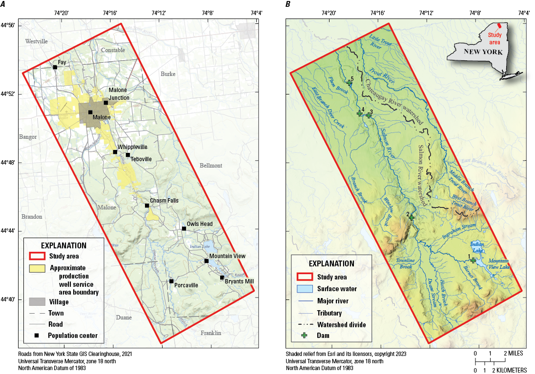
Maps showing the locations of A, political boundaries (New York State GIS Resources, 2020b), the approximate production well service area boundary (New York State GIS Resources, 2020a), roads, and population centers (U.S. Geological Survey, 2016); and B, surface water (U.S. Geological Survey, 2020a), watershed divide (U.S. Geological Survey, 2016), and locations of dams including (1) Mountain View Lake Dam, (2) Chasm Falls Dam, (3) Ballard Mill Dam, (4) Whittelsey Dam, and (5) Lamica Lake Dam (U.S. Army Corps of Engineers, 2018), along the Salmon River corridor in northern Franklin County, New York.
Data Sources and Methods
Methods and respective data sources used for the development of geospatial layers are described below and in Fisher and others (2025a, b). A surficial geologic map and derivative layers were created using light detection and ranging (lidar) 1-meter resolution data (Federal Emergency Management Agency, 2017), 10-meter digital elevation data (U.S. Geological Survey, 1995), data from the Soil Survey Geographic (SSURGO) database (U.S. Department of Agriculture, 2019), and a compilation of earlier geologic maps (Postel and others, 1956a, b; MacClintock and Stewart, 1965; Denny, 1974; Cadwell and Pair, 1991; Gadd and others, 1993). Well and boring logs from prior USGS investigations and from State agencies (New York State Department of Environmental Conservation [NYSDEC], Water Well Contractor Program; New York State Department of Transportation [NYSDOT]; USGS National Water Information System [NWIS; U.S. Geological Survey, 2020b]) were also used to define the valley-aquifer boundary, evaluate overburden thickness, define the spatial extent of unconfined and confined glacial aquifers, and delineate the spatial extent of the Potsdam Sandstone. Water levels reported by drillers at the time of well completion were used to construct a generalized potentiometric-surface map for the Potsdam Sandstone aquifer. The Topo to Raster Tool in ArcGIS Pro, version 10.7.1 was used to generate an overburden thickness map (Esri, Redlands, California). The geographic location of all well and boring sites used in this study were verified and mapped. Data from drillers' well logs were added to the record. A table of wells and borings that informed this study are provided in Fisher and others (2025a) and were entered into the USGS NWIS database (U.S. Geological Survey, 2020b).
Horizontal-to-vertical spectral ratio (HVSR) passive seismic surveys were completed at a total of 21 sites in the study area. Quality control checks were conducted to ensure that the two seismometers used in this study were functioning properly; this includes one side-by-side check measurement at one site with both seismometers, and seven control measurements next to wells with known bedrock depths. The HVSR method is a non-invasive and cost-effective tool for estimating the thickness of unconsolidated sediments over bedrock. This technique uses a single broadband three-component seismometer (x, y, and z directions) to record ambient seismic noise. The ratio of the averaged horizontal (x, y) to vertical (z) frequency spectrum is used to produce a spectral ratio curve and determine a peak resonant frequency for each site. This frequency can be empirically related to sediment thickness by using average local sediment shear-wave velocity or power-law regression analysis calibrated with a local site of known depths to bedrock (Ibs-von Seht and Wohlenberg, 1999; Lane and others, 2008; Chandler and Lively, 2014; Johnson and Lane, 2016).
HVSR data were collected for at least 30 minutes at each site using a Tromino Model TEP–3C1 three-component seismometer and published in Fisher and others (2025b). The data were processed with Grilla 2018 Rel. 8.0 software to (1) normalize the spectral traces, (2) remove background anthropogenic noise, (3) transform time-domain data to frequency domain data, (4) calculate spectral ratio curves, and (5) determine the resonance frequency (Heisig and Fleisher, 2022; Fisher and others, 2025b).
Two regression equations, derived from 43 control-point measurements with known bedrock depths from locations across upstate New York, including Malone, were used to estimate overburden thickness (Heisig and others, 2021; Fisher and Keto, 2022; Heisig and Fleisher, 2022; Heisig and Izdebski, 2022). The two equations used include the following: a high-velocity equation, y= 366.85∙x−1.038, where y is equal to bedrock depth in feet and x is the measured resonance frequency in hertz; and a low-velocity equation, y=282.38∙x−1.235, where y is equal to the bedrock depth in feet, and x is equal to the measured resonance frequency in hertz. These equations are described in detail in figure 2 of Heisig and Fleisher (2022). The high-velocity equation was used for measurements within the valley fill aquifer boundary where the sediments are composed of coarse sand and gravel, till, and mixed stratified sediments of thicknesses of 245 feet or greater. The low-velocity equation was used for measurements where overburden is 50 to 275 feet thick and the mixed stratified sediments are generally fine grained.
Bedrock Geology
The Saint Lawrence lowlands in the northern part of the study area are underlain by Late Cambrian to Early Ordovician sedimentary rocks that gently dip to the north and that overlie the highly metamorphosed rocks of the Adirondack Mountains (fig. 2). The sedimentary rocks include the Potsdam Sandstone and Theresa Formation (Postel and others, 1956a; Wiesnet, 1961; Rickard, 1973; Denny, 1974; Selleck, 1978; Lowe and others, 2015; Chiarenzelli and Selleck, 2016; Lowe and others, 2017; Hersi and others, 2021). The Potsdam Sandstone irregularly transitions upward from heterogeneous felspathic and argillaceous rock to a homogeneous, quartz-rich and matrix-poor rock (Williams and others, 2010). The dolomitic sandstones and sandy dolomite of the Theresa Formation overlie the Potsdam Sandstone and can be distinguished from it by its lesser feldspar content, absence of zircon, and greater rounding of quartz particles (Wiesnet, 1961; Williams and others, 2010). Both the Potsdam Sandstone and Theresa Formation can be found in outcrops in Plum Brook, East Branch Deer Creek, and the Salmon and Trout Rivers. The Altona formation (Lowe and others, 2015) underlies the Potsdam Sandstone east of the study area boundary, and although its western extent is unknown, it may be in the eastern part of the study area (Landing and others, 2009; Lowe and others, 2017; Landing and others, 2019; Hersi and others, 2021).
The foothills of the Adirondack Mountains in the southern part of the study area are underlain by strongly deformed Precambrian metamorphic rocks, mostly granitic gneiss (fig. 2; Isachsen and others, 2000). The resistant metamorphic rocks create substantial topographic relief in the foothills of the Adirondack Mountains. Features composed of metamorphic rock in the area include the Owls Head, Goldsmith, and Plumadore Ranges, and Titusville Mountain and Studley Hill. The Owls Head Range is underlain by Lyon Mountain Granite Gneiss; the Goldsmith and Plumadore Ranges are underlain by Hawkeye Granite Gneiss outcrops; and Titusville Mountain and Studley Hill are underlain by quartz syenite gneiss (fig. 2; Nelson and others, 1956; Postel and others, 1956b).
The study area contains two sets of roughly perpendicular topographic lineaments from fractures that trend southwest-to-northeast and southeast-to-northwest (fig. 2; Isachsen and McKendree, 1977; Earth Satellite Corporation, 1997). These fractured zones intersect both the sedimentary and metamorphic rocks. The age and origin of these and other fracture features are not known but may be a result of regional tectonic events during the Grenville orogeny and the current, slow rise of land-surface elevation throughout the Adirondack Mountain region following deglaciation (Isachsen and others, 2000). There are likely additional brittle structures, but these are concealed by extensive glacial sediments that mantle the region (Postel and others, 1956b).
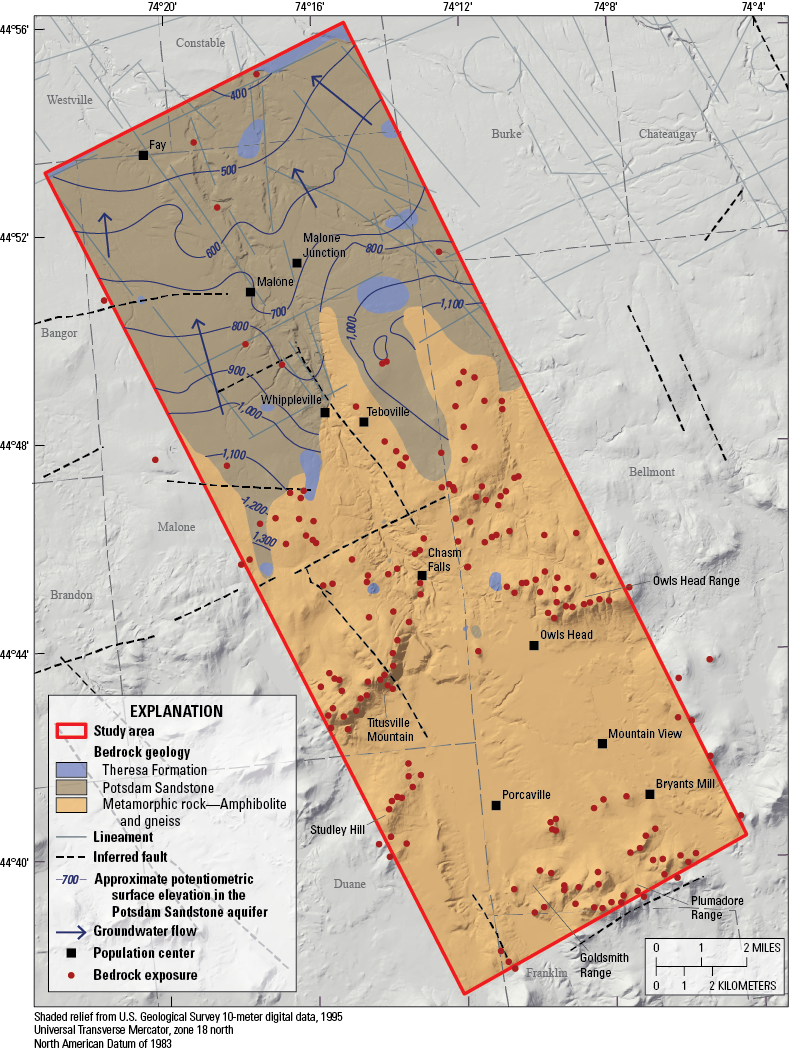
Geologic map showing bedrock geology (Isachsen and Fisher, 1970; Fisher and others, 2025a), town boundaries (New York State GIS Resources, 2020b) and population centers, lineaments (Earth Satellite Corporation, 1997), inferred faults (Isachsen and McKendree, 1977), an approximate potentiometric surface in the Potsdam Sandstone aquifer (Fisher and others, 2025a), groundwater flow direction, and bedrock exposures (Postel and others, 1956a, Postel and others, 1956b; Nelson and others, 1956; Fisher and others, 2025a), along the Salmon River corridor in northern Franklin County, New York.
Glacial Geology
The study area landscape today was largely shaped by the former action of glacial ice. Throughout the past 2.5 million years, the northeastern United States was intermittently covered by continental ice sheets (Ruddiman and Wright, 1987; Randall, 2001). The sediments deposited in the study area, however, are limited to the late Wisconsinan glacial stage and were deposited in five major phases: glacial, deglacial, lacustrine, marine, and postglacial. During the late Wisconsinan glacial stage, the region was covered by ice moving south-to-southwest, which abraded exposed bedrock, produced striae and megascale glacial lineations, and deposited lodgment till (fig. 3). During deglaciation, ablation till and stratified sediments were deposited in the region (Denny, 1974; Clark, 1980; Clark and Karrow, 1984, Franzi and others, 2016).
After the retreat of the glacier north out of the Saint Lawrence lowlands, the northern part of the study area and the present area of Lake Ontario were occupied by the main phase of glacial Lake Iroquois, and fine sand, silt, and clay accumulated in the lake and the northern half of the study area. Other, smaller proglacial-lake (lacustrine) environments in the southern part of the study area also enabled deposits of fine sand, silt, and clay (Clark, 1980; Clark and Karrow, 1984; Franzi and others, 2015; Franzi and others, 2016). Synchronous retreat of the ice margin from the Champlain valley in New York and Vermont allowed proglacial lakes to expand northward at the Ellenburg ice margin (fig. 3; Franzi and others, 2002; Franzi and others, 2015). When the Ellenburg ice margin recession uncovered Covey Hill just north of the United States-Canada Border, glacial Lake Iroquois drained catastrophically through the Covey Hill outlet initially to the level of proglacial Lake Fort Ann, and subsequently enabling the deposition of the Malone delta (fig. 3, MacClintock and Stewart, 1965; Randall, 2001). Further lowering of Lake Fort Ann resulted in shallower lacustrine phases, and fine-to-medium sand and gravel being deposited as beaches and deltas, including the Constable delta (fig. 3), at the northwestern limit of the study area (MacClintock and Stewart, 1965; Clark, 1980; Cadwell and Pair, 1991; Randall, 2001).
The retreat of the Laurentide Ice Sheet margin north of Warwick, Quebec, allowed glacial Lake Fort Ann to drain into the Gulf of Saint Lawrence (Clark and Karrow, 1984; Pair and Rodrigues,1993; Rayburn and others 2005; Franzi and others, 2016). Isostatic depression coupled with ice recession resulted in the Champlain Sea incursion (Pair and others, 1988; Pair and Rodrigues, 1993; Rayburn and others 2005, 2007; Cronin and others, 2012). During the incursion, marine silt and clay were deposited as plains; whereas fine-to-medium sand and sandy-to-bouldery gravel were deposited as beaches within the study area (Clark, 1980; Cadwell and Pair, 1991; Randall, 2001). Stratified sediments deposited during the postglacial period include floodplain alluvium and alluvial fan deposits (figs. 4, 5).
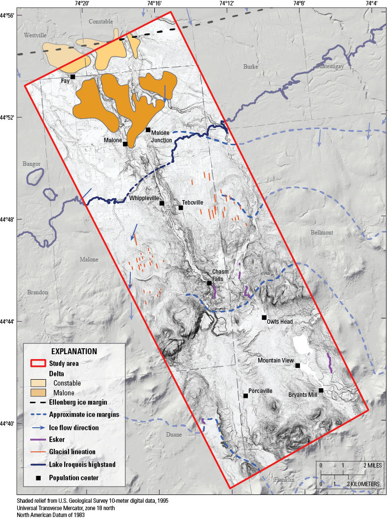
Geologic map showing the approximate location of ice margins during deglaciation, including the Ellenburg ice margin (Franzi and others, 2015) and other approximate ice margins (Denny, 1974); Malone delta and Constable delta (Randall, 2001); the glacial Lake Iroquois shoreline (based on Franzi and others, 2016; modified for this figure in consultation with David A. Franzi, State University of New York at Plattsburgh); glacial lineations and eskers (Fisher and others, 2025a); and ice-direction indicators (Ogilvie, 1902; MacClintock and Stewart, 1965; Gadd and others, 1993); along the Salmon River corridor in northern Franklin County, New York.
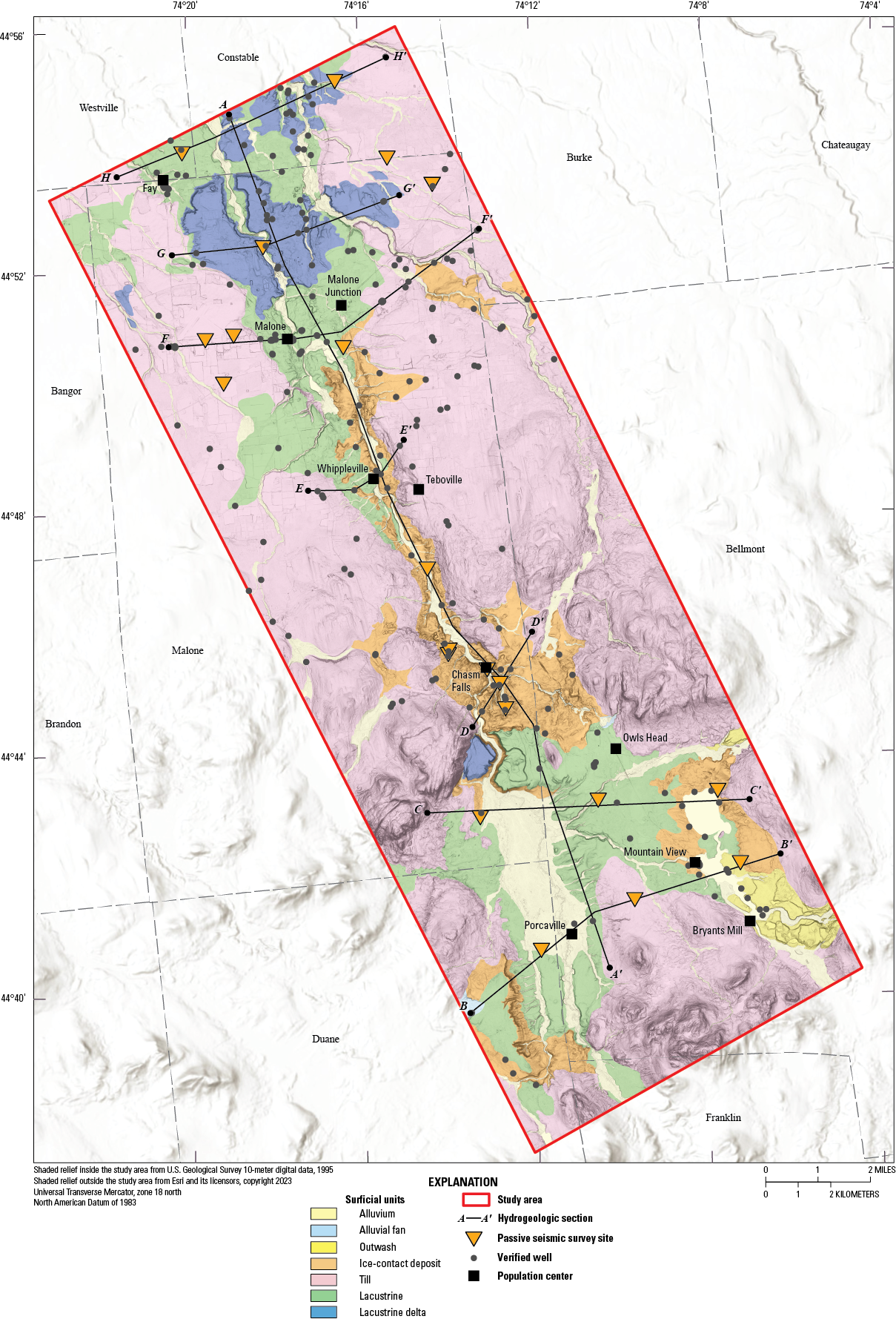
Map showing surficial geology and locations of wells, passive seismic survey sites, and hydrogeologic sections A–Aʹ to H–Hʹ, along the Salmon River corridor in northern Franklin County, New York. Data from Fisher and others (2025a). Towns and population centers from New York State GIS Resources (2020b).
Groundwater Use
Groundwater is the primary source for commercial, industrial, and domestic water within the study area. Households and facilities that use municipal water were identified using tax parcel data from New York State GIS Resources (2020a) combined with population data from the U.S. Census Bureau (2020). Within the study area boundary, approximately 13,200 residents use water supplied from two production wells (U.S. Environmental Protection Agency, 2022), whereas an estimated 2,600 people rely on domestic wells that tap unconsolidated and bedrock aquifers.
Two production wells drilled to bedrock are completed in a thick unconsolidated aquifer south of Chasm Falls. These wells provide most of the water to study area residents not served by individual domestic wells (table 1). Data compiled from 2010 to 2018, excluding 2013, indicate that these production wells have an average yield of more than 1,500 gallons per minute (gal/min) and that the average annual withdrawal was 2.11 million gallons per day (Mgal/d; New York State Department of Environmental Conservation, 2020). The Potsdam Sandstone aquifer is tapped by 74 (40 percent) of the 187 verified domestic wells within the study area. The metamorphic bedrock aquifer is tapped by 38 (20 percent) of the domestic wells, the Theresa Formation is tapped by 12 (6 percent) wells, and an undefined bedrock aquifer supplies 18 (10 percent) of the wells in the study area.
Withdrawals for domestic wells that are completed in unconsolidated aquifers were estimated using orthoimages and tax parcels by counting houses, businesses, and farms within the aquifer boundary but outside the area served by the two production wells. The number of wells that are known to tap into bedrock were subtracted from this estimation, resulting in a count of an estimated 1,111 properties with potential wells that tap the glacial aquifer system. The resulting value is likely an overestimate, as the total number of bedrock wells in the study area are unknown. The count of properties with wells was multiplied by 2.34, the average number of persons per household in Malone (U.S. Census Bureau, 2020), resulting in an estimate of 2,600 people that relied on water withdrawn from private sand and gravel wells. The estimated withdrawal from wells other than the two active production wells was 195,000 gallons per day (gal/d) and 71.2 million gallons per year (Mgal/yr) from the unconsolidated aquifers (table 2). This total is an estimate based on an average water use of 75 gal/d per person for private water systems in New York (Dieter and others, 2018).
Table 1.
Summary of average and average annual withdrawals from two active production wells from 2010 to 2018 (excluding 2013) in Malone, New York.[Average annual withdrawals (Mgal/d) from New York State Department of Environmental Conservation (2020). n, number; gal/min, gallon per minute; Mgal/d, million gallons per day; —, no data; NA, not applicable]
Table 2.
Estimated groundwater withdrawals from the unconsolidated aquifer by means of domestic and production wells in the Salmon River corridor, Franklin County, New York.[—, not applicable]
The estimated number of wells that tap the unconsolidated aquifer were determined by a visual count of homes and farms overlying the aquifer, using orthoimagery and tax parcels.
Data from U.S. Census Bureau (2020).
Data from Dieter and others (2018, p. 23).
Estimated withdrawals provided by the New York State Department of Environmental Conservation (2020).
Hydrogeology
The spatial distributions of surficial sediments are presented in figure 4 and described in figure 5. The relations between surficial geology, subsurface glacial and postglacial deposits, and the underlying bedrock geology are presented in eight hydrogeologic sections (figs. 6–13); one section longitudinally transects the length of the Salmon River valley (fig. 6), and seven roughly cross the valley from west to east (figs. 7–13). Population centers identified in figure 1 are labeled horizontally above each cross-section. An isopach map depicts the approximate thicknesses of unconsolidated deposits within the valley in figure 14.
Unconsolidated Aquifers
The study area has the following three distinct types of unconsolidated aquifers as described by Randall (2001): (1) surficial sand-plain aquifers composed of stratified lacustrine and deltaic deposits near the northern boundary of the study area in Constable and Westville; (2) unsaturated mountain-front deltaic deposits that lie above the modern stream grade that are deeply incised, transition from sand and gravel downward to fine sand, and are located in the Town of Malone north of the village of Malone; and (3) coarse stratified valley-fill deposits widespread in most valleys in the southwestern part of the study area in the Towns of Malone, Duane, Bellmont, and Franklin.
Alluvial, outwash, lacustrine, deltaic, and ice-contact sand and gravel form the principal aquifers in the study area (figs. 6–10). These deposits, where exposed at the surface, also serve as recharge areas for the surficial and bedrock aquifers. Glacial till and thick lacustrine silt and clay deposits are less permeable and act as a confining or semiconfining layer to the surficial and bedrock aquifers. Thick (>30 feet), continuous deposits of medium to fine lacustrine sands deposited by glacial and proglacial lakes overlie the ice-contact deposits and are shown in sections A–Aʹ, B–Bʹ, and C–Cʹ (figs. 6–8). Thin, discontinuous lacustrine, and commonly gravelly deposits are in the northern part of the study area, as depicted in sections E–Eʹ, F–Fʹ, and H–Hʹ (figs. 10, 11, 13). The Salmon River valley bottom is filled with alluvium with thicknesses of up to 10 to 70 feet, and 1 to 10 feet in its tributaries (figs. 6–13).
The approximate extents of unconsolidated aquifers in the study area were delineated (fig. 15) through integrated analysis of well and borehole logs, HVSR measurements, and surficial geology (figs. 6–13). Both confined and unconfined sand and gravel aquifers are within the study area (fig. 15). The unconfined aquifers in the study area consist of saturated deposits of sand and gravel, above beds of lacustrine silt and clay, or till, or bedrock. The confined aquifers are composed of deposits of sand and gravel below confining beds of lacustrine deposits and till. Twenty-four percent of the 187 wells that are used for domestic water withdrawal in the study area and outside of the production well service area boundary are in unconsolidated aquifers. Depths of domestic wells in unconsolidated aquifers range from 30 feet to 360 feet, with a median of 118 feet. The reported yield for these wells ranges from 3 to 60 gal/min, with a median of 20 gal/min (fig. 16). Most domestic wells are not screened but completed as open hole and do not represent the true well yield potential of the unconsolidated aquifers. Two production wells near Chasm Falls have a combined average withdrawal of more than 1,500 gal/min (table 1). These highly productive wells are in an unconfined sand and gravel aquifer and likely induce infiltration from the Salmon River (Winslow and others, 1965; Alley and others, 1999).
The distribution of surficial facies depicted in figure 4 is consistent with the type of regional deglaciation described by Fairchild (1913, 1919), MacClintock and Stewart (1965), Clark and Karrow (1984), and Franzi and others (2016). As the glacier receded, the ice thinned and revealed lodgement till in the foothills of the Adirondack Mountains and along the valley walls. The valley walls of the Salmon River and surrounding uplands are covered with unstratified deposits of ablation till that were directly deposited by the glacier. Till consists of dense, unsorted sediment that has a fine-grained matrix (such as silt and clay), containing some pebbles, cobbles, and boulders throughout. Till generally has low permeability and yields limited amounts of water (Miller and others, 2022). Till originating from the Potsdam Sandstone tends to contain clasts of pebble and cobble size, whereas till from granitic gneiss contains a high proportion of sand-sized particles (Denny, 1974), resulting in some permeability.
In several locations, the retreating glacier left behind thick (>200 ft), stratified, and variably sorted ice-contact sediments, which were deposited by glacial meltwater in subaerial and subaqueous environments as fine- and coarse-grained layers, as depicted in sections A–Aʹ, B–Bʹ, C–Cʹ, and D–Dʹ (figs. 6–9). Till is likely interbedded with these layers because of slumping, mass movement from melting ice, or deposition from ice during minor readvances of the ice front (fig. 8). Common landforms associated in glaciated terranes include end moraines and ice-contact features such as terraces, pitted outwash, eskers, and deltas.
At section D–Dʹ, near the center of the study area, thick ice-contact deposits, consisting of stratified layers of sand, gravel, cobbles, and minor boulders, fill the valley (fig. 9). These coarse-grained sediments compose the aquifer framework due to their hydraulic conductivity and permeability, which allow for usable water yields. Well yields along this section range from 40 to 97 gal/min. This section is slightly northwest of an approximate ice margin (Denny, 1974), as shown in figure 3. A large southward sloping ice-contact delta was deposited in a proglacial lake confined to the Salmon River valley. The ice-contact delta has an elevation of 1,560 feet and is west of the population center of Owls Head along the upper Salmon River, south of D–Dʹ, and provides evidence that large meltwater streams drained into the Adirondack Mountains shortly before glacial Lake Iroquois expanded into the Saint Lawrence lowlands and the direction of meltwater flow in the northern Adirondack valleys reversed (Randall, 2001).
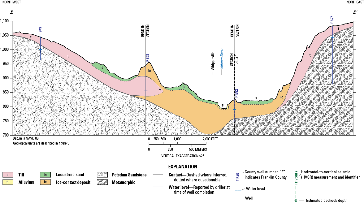
The valley broadens northward near Whippleville, south of Malone, at sections E–Eʹ and F–Fʹ (figs. 10, 11). Ice-contact deposits are thin, and the depth to bedrock is shallower here in comparison to the southern part of the valley. The northwest side of section E–Eʹ and the entirety of section F–Fʹ overlie the Potsdam Sandstone, which homeowners rely on for drinking water (figs. 6, 10, 11).
Section G–Gʹ (fig. 12) transects deltaic deposits composed largely of fine to coarse sand (with some gravel) that prograded over silt or clay deposited in nearly flat-topped deltas as proglacial lakes occupied the lowlands north of the Adirondack Mountains during deglaciation (Randall, 2001). The large delta in section G–Gʹ, deposited in proglacial Lake Fort Ann, marks the extent of a proglacial lake shoreline (Williams and others, 2010).
The highest elevation deltas close to the uplands are commonly coarse-grained, collapsed ice-contact deposits (Randall, 2001). Multiple deltas were built into the proglacial lakes by streams from the Adirondack Mountains to the south. The fine-grained deposits of sand, silt, and clay in lacustrine deposits have a low permeability and generally are a poor groundwater resource. Local domestic wells typically withdraw groundwater from the Potsdam Sandstone aquifer (figs. 6, 12).
Section H–Hʹ (fig. 13), located at the northern boundary of the study area, shows flat lying ice-contact deposits overlying the Potsdam Sandstone. Some shallower wells tap into these stratified ice-contact deposits; however, most wells tap the bedrock aquifer.
Descriptions of stratified and unstratified sediments depicted in the surficial geologic map (fig. 4) and hydrogeologic cross sections (figs. 6–13).
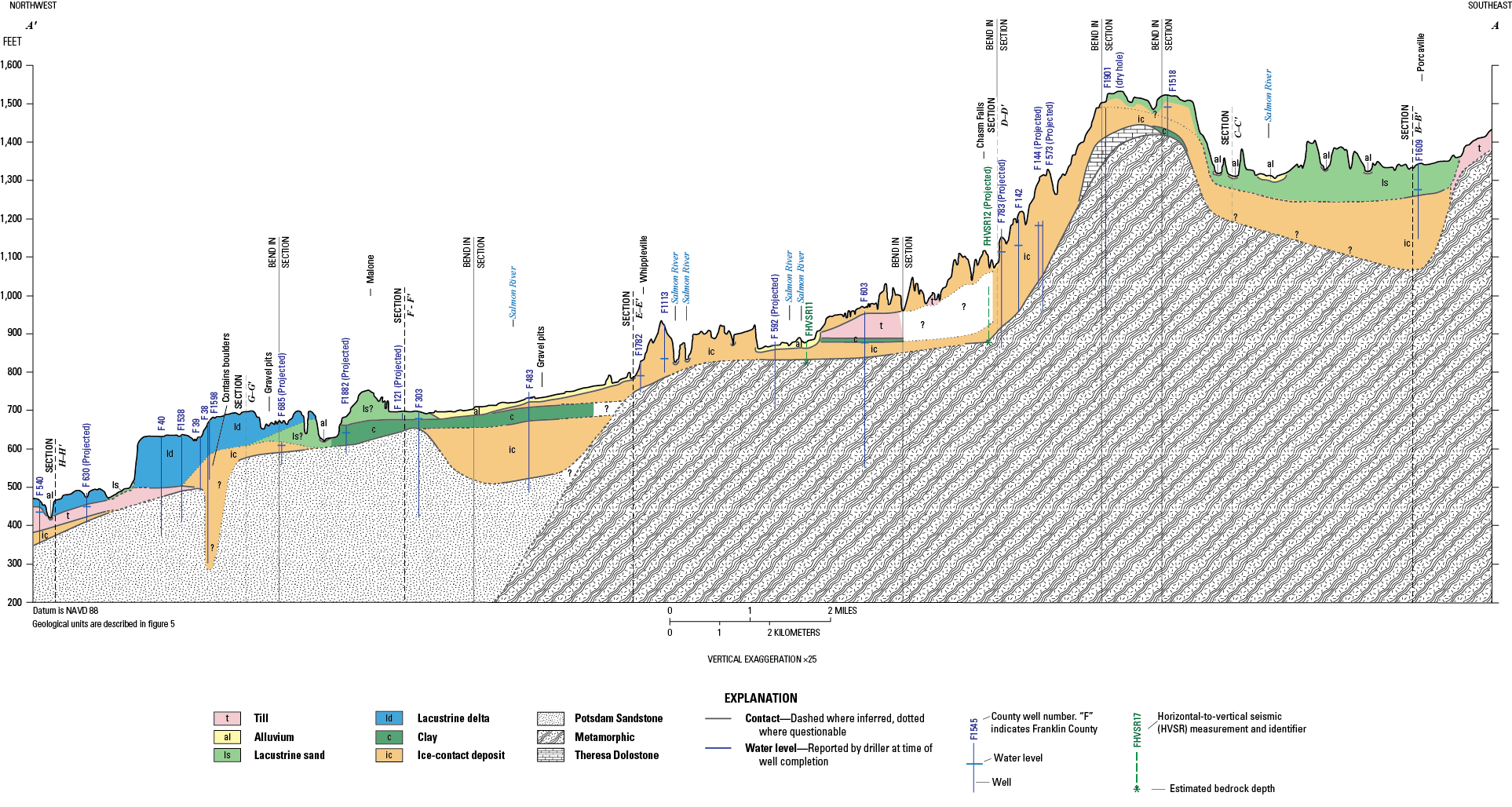
Hydrogeologic longitudinal cross section A–Aʹ of the Salmon River from the Town of Constable to Bellmont, New York (Fisher and others, 2025a, b). Section line is shown on figure 4; horizontal scale of section differs from map scales. Question mark “?” indicates unknown deposit.
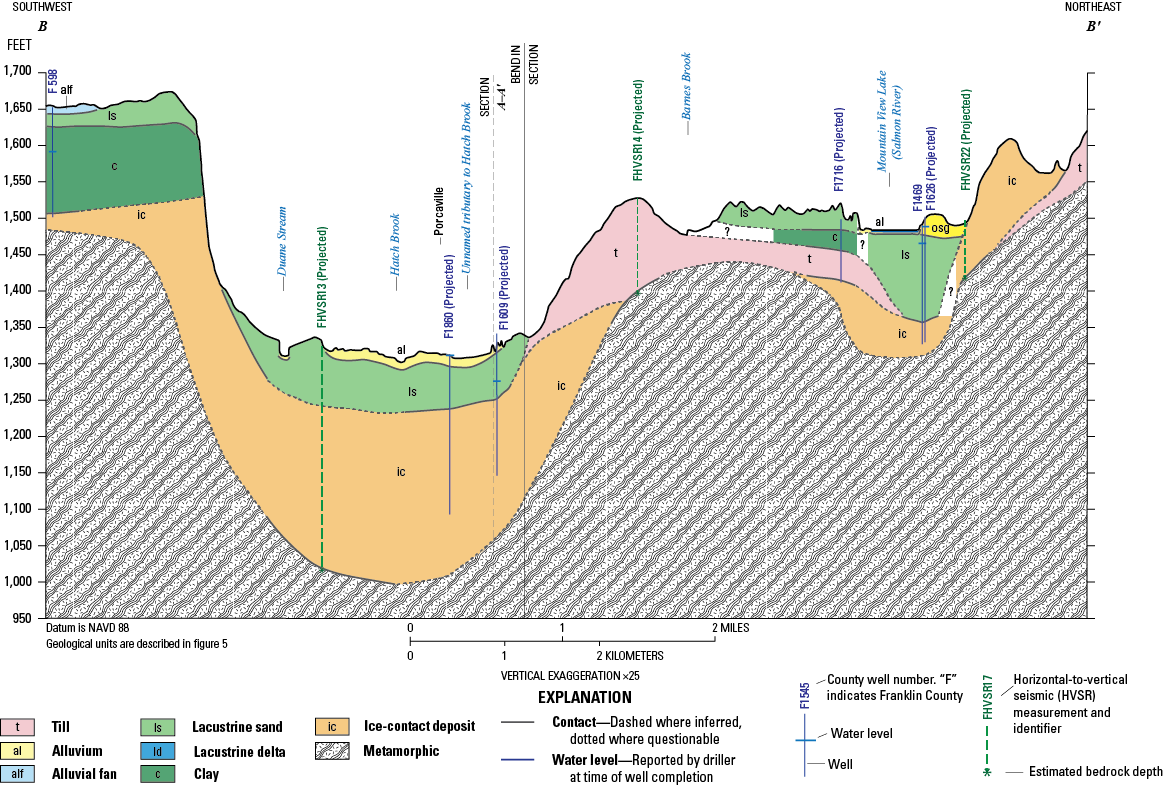
Hydrogeologic section B–Bʹ, Salmon River at Porcaville, New York (Fisher and others, 2025a, b). Section line is shown on figure 4; horizontal scale of section differs from map scales. Sediments are described in figure 5. Clay is sandy near well F 598. Silt is present near well F1469.
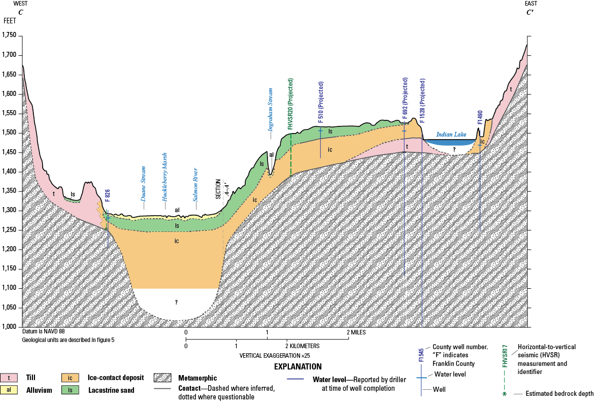
Hydrogeologic section C–Cʹ, Salmon River at Huckleberry Marsh, New York (Fisher and others, 2025a, b). Section line is shown on figure 4; horizontal scale of section differs from map scales. Sediments are described in figure 5.
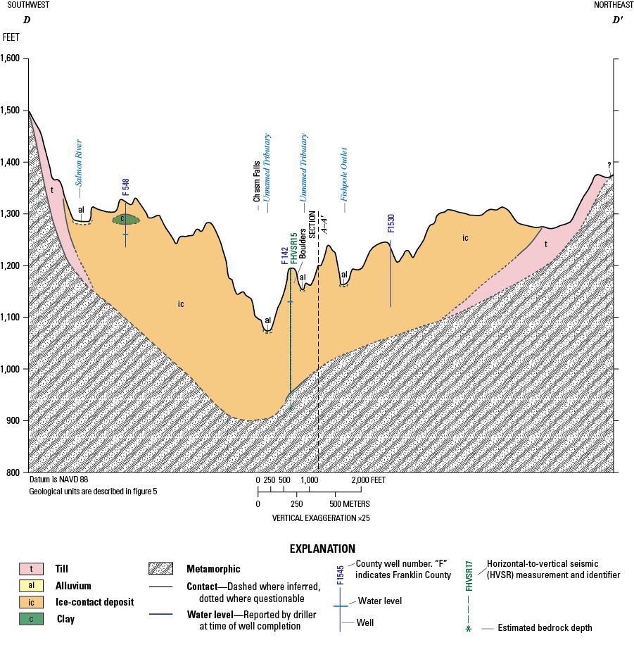
Hydrogeologic section D–Dʹ, Salmon River at Chasm Falls, New York (Fisher and others, 2025a, b). Section line is shown on figure 4; horizontal scale of section differs from map scales. Sediments are described in figure 5. Boulders are present near well F 142.
Hydrogeologic section E–Eʹ, Salmon River at Whippleville, New York (Fisher and others, 2025a, b). Section line is shown on figure 4; horizontal scale of section differs from map scales. Sediments are described in figure 5.
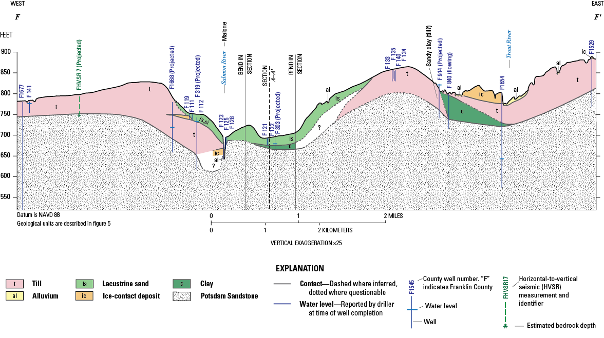
Hydrogeologic section F–Fʹ, Salmon River at the Village of Malone, New York (Fisher and others, 2025a, b). Section line is shown on figure 4; horizontal scale of section differs from map scales. Sediments are described in figure 5. Silt and some gravel present in the lacustrine sand near the Salmon River valley. Till is sandy near well F 914.
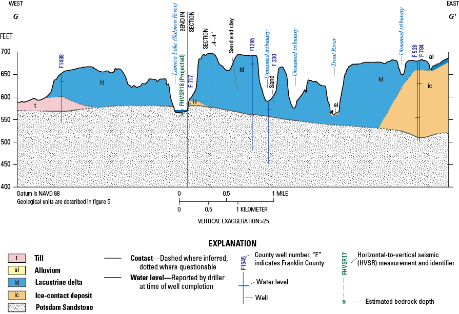
Hydrogeologic section G–Gʹ, Lamica Lake (Salmon River) north of Malone, New York (Fisher and others, 2025a, b). Section line is shown on figure 4; horizontal scale of section differs from map scales. Sediments are described in figure 5. Well logs describe layered coarse, medium, and fine sand and gravel sediments near wells F 528 and F 784.
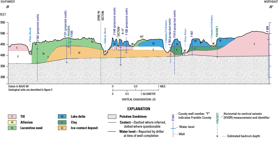
Hydrogeologic section H–Hʹ, Salmon River near Constable, New York (Fisher and others, 2025a, b). Section line is shown on figure 4; horizontal scale of section differs from map scales. Sediments are described in figure 5. Question mark “?” indicates unknown deposit.
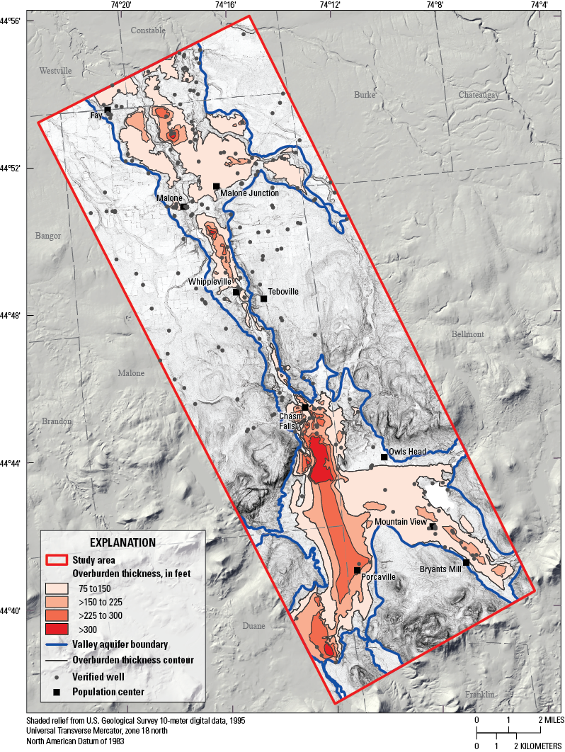
Geologic map showing thickness of unconsolidated deposits (Fisher and others, 2025a) and location of wells with overburden thickness data, along the Salmon River corridor in northern Franklin County, New York. Towns and population centers are from New York State GIS Resources (2020b). >, greater than.
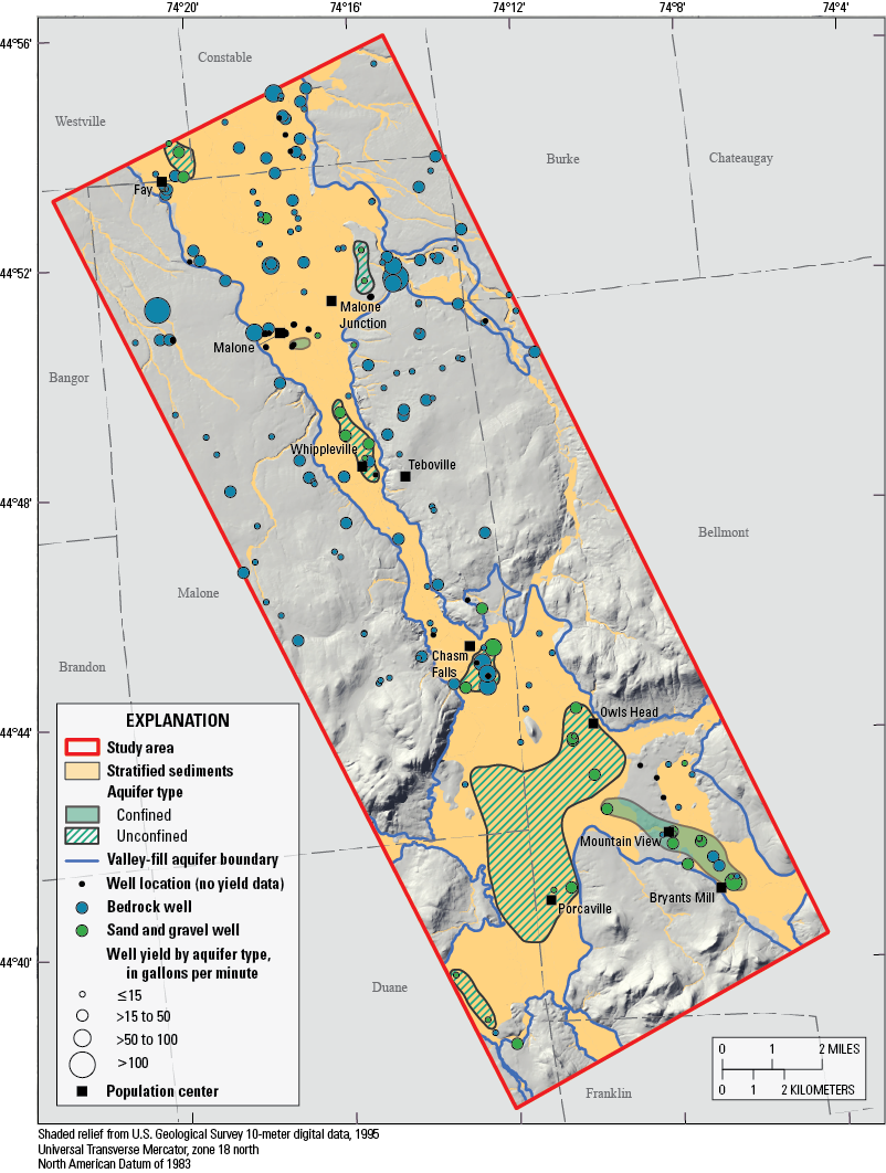
Geologic map showing approximate locations of 2 confined and 6 unconfined aquifers and the approximate valley-fill aquifer boundary in relation to stratified sediments, along the Salmon River corridor in northern Franklin County, New York. Confining units include thick deposits of clay or till, and unconfined aquifers are typically thick surficial deposits of sand and gravel. The map (fig. 15) depicts the distribution of well by yields in gallons per minute based on aquifer type: glacial (green) and bedrock (blue). Towns and population centers are from New York State GIS Resources (2020b). ≤, less than or equal to; ≥, greater than or equal to.
Bedrock Aquifers
Groundwater in the sedimentary and metamorphic bedrock aquifers is stored and flows in secondary porosity, such as separations along bedding and foliation planes, joints, faults, and other fractures. The uppermost part of the bedrock in the study area typically is weathered and fractured and, where saturated, readily transmits groundwater. The Potsdam Sandstone forms a fractured-rock aquifer of regional extent, with bedding-related fracture zones with transmissivities that convey usable quantities of water. Hydraulic-head gradients in the aquifer commonly are downward with a laterally extensive series of sub-horizontal flow zones serving as drains for the groundwater flow system. (Williams and others, 2010).
Water levels reported by drillers at the time that wells were completed, between 1977 to 2017, were used to construct a generalized potentiometric-surface map for the Potsdam Sandstone aquifer (fig. 2). Groundwater generally flows from recharge areas in the foothills of the Adirondack Mountains to the Potsdam Sandstone aquifer in a north-northwest direction. Recharge occurs in areas of thin, discontinuous till or where bedrock is exposed. Thick deposits of till or lacustrine silt and clay impede groundwater recharge to the aquifer.
The Potsdam Sandstone is the most productive bedrock aquifer in the study area. Reported yields from 74 domestic wells in the Potsdam Sandstone aquifer range between 3 to 200 gal/min, with a median yield of 17 gal/min (fig. 16). Only 12 known wells are drilled into the Theresa Formation and have yields that range from 2 to 30 gal/min, with a median of 20 gal/min (fig. 16). Metamorphic rocks are the least productive and have reported well yields that range from 0 to 45 gal/min, with a median of 4 gal/min (fig. 16). Boreholes (33), production wells (2), and test wells (5) are excluded in this assessment.
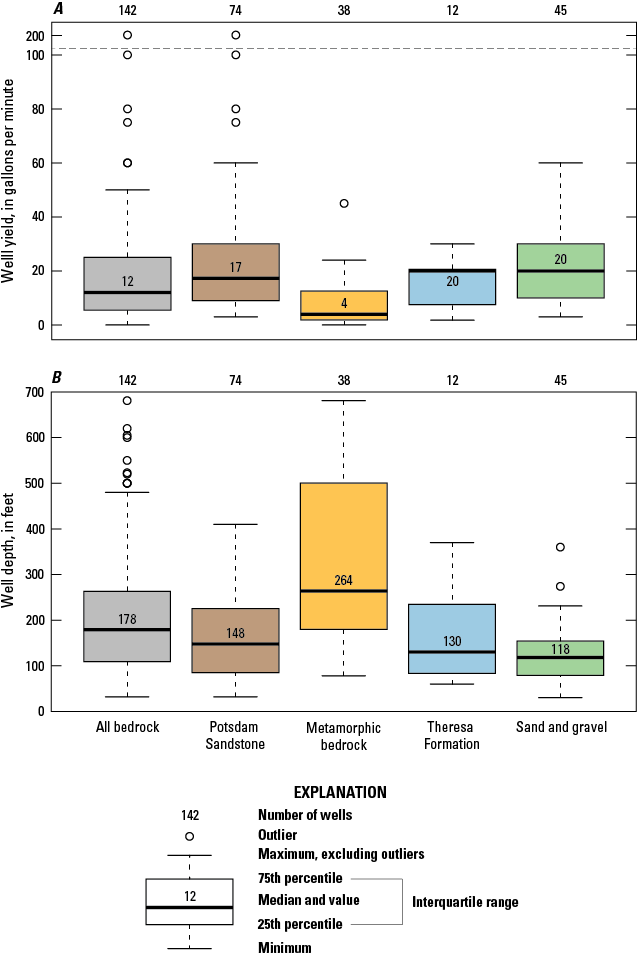
A, Well yield (gallons per minute) and B, well depth (feet) of verified wells in the study area. Two production wells are excluded from this boxplot. In addition to the bedrock wells drilled into known units (Potsdam Sandstone [74], metamorphic bedrock [38], and Theresa Formation [12]), there are 18 undefined bedrock wells included in the "all bedrock" category. Dashed line shows a break in the y-axis.
Summary
This report presents the findings of an investigation of the hydrogeology of the Malone valley-fill aquifer system and associated water resources in northern Franklin County, New York, led by the U.S. Geological Survey in cooperation with the New York State Department of Environmental Conservation. The study included data and interpretations contained in soil-survey maps, topographic maps, lidar, well records, and the published reports included in the “References Cited” section of this report. Twenty-one horizontal-to-vertical spectral ratio (HVSR) passive seismic measurements augmented the depth-to-bedrock database and aided the effort to define the geometry of the aquifer system. All well, boring, and HVSR measurements are provided in a supporting data release. Deglaciation and the resulting glacial deposits strongly influence well productivity and the distribution of confined and unconfined aquifers within the valley. Well locations, surficial geology, thickness of unconsolidated deposits, and locations of eight hydrogeologic sections are presented in the figures contained in this report and a supporting data release.
Groundwater is the primary source for commercial, industrial, and domestic water within the study area. Two production wells, completed in an unconfined thick glacial aquifer in the foothills of the Adirondack Mountains, located south of Chasm Falls, supply water to approximately 13,200 people, including three correctional facilities. The production wells yield an average of more than 1,500 gallons per minute (gal/min) and are likely receiving induced infiltration from the Salmon River. Most residents outside the area served by the two production wells rely on domestic wells that are drilled into bedrock aquifers. Domestic bedrock wells produce water at a rate between 0 gal/min to 200 gal/min, with a median yield of 12 gal/min. Forty percent (74) of the domestic bedrock wells are drilled into the Potsdam Sandstone regional aquifer. Wells drilled into the Potsdam Sandstone have yields that range between 3 gal/min to 200 gal/min, with a median yield of 17 gal/min. Domestic wells that draw water from unconsolidated glacial material have yields that range between 3 to 60 gal/min, with a median yield of 20 gal/min. Groundwater-resource potential is highest in the valley-bottom sediments south of Chasm Falls near the foothills of the Adirondack Mountains, where three unconfined aquifers and one confined aquifer are identified. Ice-contact, alluvial, outwash, and deltaic deposits form unconfined and confined aquifers; glacial till and thick clay act as a confining or semiconfining layer. Unconfined aquifers in the study area are potentially susceptible to contamination by runoff from concentrated animal feeding operations (CAFOs), and contamination from the use of pesticides and other chemicals overlying the unconfined aquifer.
References Cited
Alley, W.M., Reilly, T.E., and Franke, O.L., 1999, Sustainability of ground-water resources: U.S. Geological Survey Circular 1186, 79 p., accessed April 1, 2025, at https://pubs.usgs.gov/circ/circ1186/pdf/circ1186.pdf.
Beck, H.E., Zimmermann, N.E., McVicar, T.R., Vergopolan, N., Berg, A., and Wood, E.F., 2018, Present and future Köppen-Geiger climate classification maps at 1-km resolution: Scientific Data, v. 5, no. 1, article 180214, 12 p., accessed July 6, 2020, at https://doi.org/10.1038/sdata.2018.214.
Cadwell, D.H., and Pair, D.L., 1991, Surficial geologic map of New York—Adirondack sheet: New York State Museum Map and Chart Series 40, scale 1:250,000, accessed September 14, 2020, at https://www.nysm.nysed.gov/research-collections/geology/gis.
Chandler, V.W., and Lively, R.S., 2014, Evaluation of the horizontal-to-vertical spectral ratio (HVSR) passive seismic method for estimating the thickness of Quaternary deposits in Minnesota and adjacent parts of Wisconsin: Minnesota Geological Survey Open File Report 14–01, 52 p., accessed August 3, 2020, at http://hdl.handle.net/11299/162792.
Chiarenzelli, J.R., and Selleck, B.W., 2016, Bedrock geology of the Adirondack Region—Adirondack: The Adirondack Journal of Environmental Studies, v. 21, no. 1, p. 19–42, accessed September 9, 2020, at https://digitalworks.union.edu/ajes/vol21/iss1/5.
Clark, P.U., and Karrow, P.F., 1984, Late Pleistocene water bodies in the St. Lawrence lowland, New York, and regional correlations: Geological Society of America Bulletin, v. 95, no. 7, p. 805–813, accessed September 15, 2020, at https://doi.org/10.1130/0016-7606(1984)95<805:LPWBIT>2.0.CO;2.
Cronin, T.M., Rayburn, J.A., Guilbault, J.-P., Thunell, R., and Franzi, D.A., 2012, Stable isotope evidence for glacial lake drainage through the St. Lawrence Estuary, eastern Canada, ~13.1–12.9 ka: Quaternary International, v. 260, p. 55–65, accessed September 17, 2020, at https://doi.org/10.1016/j.quaint.2011.08.041.
Dieter, C.A., Maupin, M.A., Caldwell, R.R., Harris, M.A., Ivanhnenko, T.I., Lovelace, J.K., Barber, N.L., and Linsey, K.S., 2018, Estimated use of water in the United States in 2015: U.S. Geological Survey Circular 1441, 65 p., accessed October 16, 2024, at https://doi.org/10.3133/cir1441. [Supersedes USGS Open-File Report 2017–1131.]
Fairchild, H.L., 1913, Pleistocene geology of New York State: Science, v. 37, no. 946, p. 237–249, accessed September 10, 2020, at https://doi.org/10.1126/science.37.946.237.
Fairchild, H.L., 1919, Pleistocene marine submergence of the Hudson, Champlain and St. Lawrence valleys: New York State Museum Bulletin, nos. 209/210, 76 p., accessed September 10, 2020, at https://www.nysm.nysed.gov/publications/bulletins.
Federal Emergency Management Agency, 2017, St. Lawrence Franklin 2017 1-meter LiDAR: Federal Emergency Management Agency web page, accessed September 15, 2020, at https://elevation.its.ny.gov/arcgis/rest/services/FEMA_2019_1_meter/ImageServer.
Fisher, S.R., Grey, E.I., Van Hoesen, J.G., Heisig, P.M., and Woda, J.C., 2025a, Geospatial datasets for the glacial geology and hydrogeology of the Salmon River corridor from the Adirondack Foothills to the St. Lawrence Lowlands, including Malone, Franklin County, New York: U.S. Geological Survey data release, https://doi.org/10.5066/P9SX7MV2.
Fisher, S.R., Heisig, P.M., and Van Hoesen, J.G., 2025b, Horizontal-to-vertical spectral ratio (HVSR) measurements and depth to bedrock estimates along the Salmon River corridor from the Adirondack Foothills to the St. Lawrence Lowlands, Franklin County, New York, 2018-2023: U.S. Geological Survey data release, https://doi.org/10.5066/P946DA5G.
Fisher, B.N., and Keto, D.S., 2022, Horizontal-to-vertical seismic method (HVSR) soundings in the northern and central parts of the Tug Hill glacial aquifer, Jefferson and Oswego Counties, north central New York: U.S. Geological Survey data release, accessed October 16, 2024, at https://doi.org/10.5066/P9WBXE5F.
Franzi, D.A., Barclay, D.J., Kranitz, R., and Gilson, K., 2015, Quaternary deglaciation of the Champlain Valley with specific examples from the Ausable River Valley, in Franzi, D.A., ed., Geology of the northeastern Adirondack Mountains and Champlain–St. Lawrence Lowlands of New York, Vermont and Québec—New York State Geological Association 87th Annual Meeting, Plattsburgh, N.Y., September 12–13, 2015, Guidebook: New York State Geological Association, p. 162–190, accessed October 16, 2024, at https://www.nysga-online.org/wp-content/uploads/2022/03/2015_bookmarked.pdf.
Franzi, D.A., Rayburn, J.A., Yansa, C.H., and Knuepfer, P.L.K., 2002, Late glacial water bodies in the Champlain and Hudson lowlands, New York, in McLelland, J., and Karabinos, P., eds., New York State Geological Association-New England Intercollegiate Geological Conference Joint Annual Meeting Guidebook: p. A5 1–23, accessed October 16, 2024, at https://www.nysga-online.org/wp-content/uploads/2022/03/2002_bookmarked.pdf.
Franzi, D.A., Ridge, J.C., Pair, D.L., Desimone, D., Rayburn, J.A., and Barclay, D.J., 2016, Post-valley heads deglaciation of the Adirondack Mountains and adjacent lowlands: Journal of Environmental Studies, v. 21, no. 1, p. 119–146, accessed September 14, 2020, at https://digitalworks.union.edu/ajes/vol21/iss1/11.
Gadd, N.R., Veillette, J.J., Fullerton, D.S., Wagner, P.W., and Chapman, W.F., 1993, Quaternary geologic map of the Ottawa 4°×6° quadrangle, United States and Canada, in Fullerton, D.S., ed., Quaternary geologic atlas of the United States, U.S. Geological Survey Map I–1420, accessed September 11, 2020, at https://pubs.usgs.gov/imap/i-1420/nl-18/.
Heisig, P.M., and Fleisher, P.J., 2022, Glacial geology and hydrogeology of valley-fill aquifers in the Oneonta area, Otsego and Delaware Counties, New York: U.S. Geological Survey Scientific Investigations Report 2022–5069, 35 p., 1 pl., accessed October 6, 2022, at https://doi.org/10.3133/sir20225069.
Heisig, P.M., and Izdebski, M.A., 2022, Horizontal-to-vertical spectral ratio soundings and depth-to-bedrock data for valley-fill aquifers in the Oneonta area, Otsego and Delaware Counties, New York, 2016–2018: U.S. Geological Survey data release, accessed January 1, 2023, at https://doi.org/10.5066/P92NSO7T.
Heisig, P.M., Williams, J.H., Johnson, C.D., White, E.A., and Kappel, W.M., 2021, Horizontal-to-vertical spectral ratio and depth-to-bedrock data for saline-groundwater investigation in the Genesee Valley, New York, October-November 2016 and 2017: U.S. Geological Survey data release, accessed October 25, 2023, at https://doi.org/10.5066/P9LI7CCR.
Hersi, O.S., Landing, E., Franzi, D., and Hagadorn, J., 2021, Cambrian-Lower Ordovician of southwestern Quebec–NE New York, in Cousens, B.L., and Riggs, N., eds., GSA in the field in 2020: The Geological Society of America Field Guide 60, p. 1–32, accessed January 1, 2020, at https://doi.org/10.1130/2021.0060(01).
Ibs-von Seht, M., and Wohlenberg, J., 1999, Microtremors measurements used to map thickness of soft sediments: Bulletin of the Seismological Society of America, v. 89, no. 1, p. 250–259, accessed August 3, 2020, at https://doi.org/10.1785/BSSA0890010250.
Isachsen, Y.W., and Fisher, D.W., 1970, Geologic map of New York—Adirondack sheet: New York State Museum and Science Service Map and Chart Series 15, scale 1:250,000, accessed September 4, 2020, at https://www.nysm.nysed.gov/research-collections/geology/gis. [Reprinted in 1995.]
Isachsen, Y.W., and McKendree, W.G., 1977, Preliminary brittle structures map of New York: New York State Museum and Science Service Map and Chart Series 31A, scale 1:250,000, accessed October 16, 2024, at https://www.nysm.nysed.gov/sites/default/files/mc31_preliminarybrittlestructuresofnewyork.pdf.
Johnson, C., and Lane, J., 2016, Statistical comparison of methods for estimating sediment thickness from horizontal-to-vertical spectral ratio (HVSR) seismic methods—An example from Tylerville, Connecticut, USA, in Symposium on the Application of Geophysics to Engineering and Environmental Problems Proceedings: Denver, Colo., Environmental and Engineering Geophysical Society, p. 317–323, accessed January 1, 2018, at https://doi.org/10.4133/SAGEEP.29-057.
Landing, E., Amati, L., and Franzi, D.A., 2009, Epeirogenic transgression near a triple junction—The oldest (latest early-middle Cambrian) marine onlap of cratonic New York and Quebec: Geological Magazine, v. 146, no 4, p. 552–566, accessed January 1, 2018, at https://doi.org/10.1017/S0016756809006013.
Landing, E., Hersi, O.S., and Amati, L., 2019, Westrop., S.R., and Franzi, D.A., 2019, Early Paleozoic rifting and reactivation of a passive-margin rift—Insights from detrital zircon provenance signatures of the Potsdam Group, Ottawa graben: Geological Society of America Bulletin, v. 131, nos. 3–4, p. 695–698, accessed January 1, 2018, at https://doi.org/10.1130/B35104.1.
Lane, J.W., Jr., White, E.A., Steele, G.V., and Cannia, J.C., 2008, Estimation of bedrock depth using the horizontal-to-vertical (H/V) ambient-noise seismic method, in Symposium on the Application of Geophysics to Engineering and Environmental Problems, Philadelphia, Pa., April 6–10, 2008, Proceedings: Denver, Colo., Environmental and Engineering Geophysical Society, 13 p., accessed August 3, 2020, at https://doi.org/10.3997/2214-4609-pdb.177.170.
Lowe, D.G., Arnott, R.W.C., Nowlan, G.S., and McCracken, A.D., 2017, Lithostratigraphic and allostratigraphic framework of the Cambrian-Ordovician Potsdam Group and correlations across Early Paleozoic southern Laurentia: Canadian Journal of Earth Sciences, v. 54, no. 5, p. 550–585, accessed January 1, 2018, at https://doi.org/10.1139/cjes-2016-0151.
Lowe, D., Brink, R., and Mehrtens, C., 2015, Sedimentology and stratigraphy of the Cambrian-Ordovician, Potsdam Group (Altona, Ausable, and Keeseville Formations), northeastern NY, in Franzi, D., ed., Geology of the northeastern Adirondack Mountains and Champlain–St. Lawrence Lowlands of New York, Vermont and Québec—New York State Geological Association, 87th Annual Meeting, Plattsburgh, N.Y., September 12–13, 2015, Guidebook: New York State Geological Association, p. 120–161, accessed September 8, 2020, at https://www.nysga-online.net/wp-content/uploads/2019/07/2015_bookmarked.pdf. [Available June 2025 at https://www.nysga-online.org/wp-content/uploads/2022/03/2015_bookmarked.pdf.]
MacClintock, P., and Stewart, D.P., 1965, Pleistocene geology of the St. Lawrence Lowlands: New York State Museum and Science Service Bulletin no. 394, 152 p., accessed September 11, 2020, at https://nysl.ptfs.com/data/Library1/06042012/77704.PDF.
Miller, T.S., Fisher, B.N., and Kappel, W.M., 2022, Geohydrology and water quality of the northern and central parts of the Tug Hill glacial aquifer, Jefferson and Oswego Counties, north-central New York: U.S. Geological Survey Scientific Investigations Report 2022–5039, 54 p., https://doi.org/10.3133/sir20225039.
National Land Cover Database, 2016, NLCD 2016 land cover (CONUS): National Land Cover database, accessed May 7, 2020, at https://www.mrlc.gov/data/nlcd-2016-land-cover-conus.
National Oceanic and Atmospheric Administration, 2020, Summary of annual normals, Malone, New York (1981–2010 data): National Oceanic and Atmospheric Administration National Centers for Environmental Information database, accessed October 6, 2022, at https://www.ncei.noaa.gov/access/us-climate-normals/.
Nelson, A.E., Wiesnet, D.R., Carswell, L.D., and Postel, A.W., 1956, Geologic map of the Chateaugay quadrangle, New York: U.S. Geological Survey, Miscellaneous Geologic Investigations, Map I–168, 1 sheet, scale 1:62,500, accessed September 4, 2020, at https://ngmdb.usgs.gov/Prodesc/proddesc_1305.htm.
New York State GIS Resources, 2020a, Franklin County tax-parcel centroid points: New York State GIS Clearinghouse dataset, accessed December 6, 2021, at https://gis.ny.gov/parcels.
New York State GIS Resources, 2020b, New York State civil boundaries: New York State GIS Clearinghouse geographic database, accessed December 6, 2021, at https://gis.ny.gov/civil-boundaries.
Ogilvie, I.H., 1902, Glacial phenomena in the Adirondacks and Champlain Valley: The Journal of Geology, v. 10, no. 4, p. 397–412, accessed September 11, 2020, at https://doi.org/10.1086/621013.
Pair, D., Karrow, P.F., and Clark, P.U., 1988, History of the Champlain Sea in the central St. Lawrence Lowland, New York, and its relationship to water levels in the Lake Ontario basin, in Gadd, N.R., ed., The Late Quaternary development of the Champlain Sea basin: Geological Association of Canada, Special Paper 35, p. 107–123.
Pair, D.L., and Rodrigues, C.G., 1993, Late Quaternary deglaciation of the southwestern St. Lawrence Lowland, New York and Ontario: Geological Society of America Bulletin, v. 105, no. 9, p. 1151–1164, accessed September 15, 2020, at https://doi.org/10.1130/0016-7606(1993)105<1151:LQDOTS>2.3.CO;2.
Postel, A.W., Dodson, C.L., and Garswell, L.D., 1956b, Geology of the Loon Lake quadrangle, New York: U.S. Geological Survey, Geologic Quadrangle Maps of the United States, Map GQ63, 1 sheet, scale 1:62,500, accessed September 4, 2020, at https://doi.org/10.3133/gq63.
Postel, A.W., Wiesnet, D.R., and Nelson, A.E., 1956a, Geologic map of the Malone quadrangle, New York: U.S. Geological Survey Miscellaneous Geological Investigations Map 1–167, 1 sheet, scale 1:62,500, accessed September 4, 2020, at https://doi.org/10.3133/i167.
Randall, A.D., 2001, Hydrogeologic framework of stratified-drift aquifers in the glaciated Northeastern United States—Regional aquifer-system analysis—Northeastern United States: U.S. Geological Survey Professional Paper 1415–B, 179 p., accessed September 14, 2020, at https://doi.org/10.3133/pp1415B.
Rayburn, J.A., Franzi, D.A., Knuepfer, P.L.K., 2007, Evidence from the Lake Champlain Valley for a later onset of the Champlain Sea and implications for late glacial meltwater routing to the North Atlantic: Palaeogeography, Palaeoclimatology, Palaeoecology, v. 246, no. 1, p. 62–74, accessed September 14, 2020, at https://doi.org/10.1016/j.palaeo.2006.10.027.
Rayburn, J.A., Knuepfer, P.L.K., and Franzi, D.A., 2005, A series of large, Late Wisconsinan meltwater floods through the Hudson and Champlain Valleys, New York State, USA: Quaternary Science Reviews, v. 24, no. 22, p. 2410–2419, accessed September 14, 2020, at https://doi.org/10.1016/j.quascirev.2005.02.010.
Rickard, L.V., 1973, Stratigraphy and structure of the subsurface Cambrian and Ordovician carbonates of New York: Albany, N.Y., New York State Museum and Science Service, Map and Chart Series No. 18, 26 p., accessed September 8, 2020, at https://eric.ed.gov/?id=ED093640.
Selleck, B.W., 1978, Paleoenvironments of the Potsdam Sandstone and Theresa Formation of the southwestern St. Lawrence Lowlands, in Merriam, D.F., ed., New York State Geological Association, 50th Annual Meeting field-trip guidebook: Hamilton, New York, p. 173–184, accessed September 10, 2020, at https://www.nysga-online.org/wp-content/uploads/2019/06/NYSGA-1978-A6-Paleoenvironments-of-the-Potsdam-Sandstone-and-Theresa-Formation-of-the-Southwes tern-St.-Lawrence-Lowlands.pdf.
U.S. Army Corps of Engineers, 2018, National Inventory of Dams—Dams of the Nation: U.S. Army Corps of Engineers website, accessed November 1, 2023, at https://nid.sec.usace.army.mil/.
U.S. Census Bureau, 2018, QuickFacts—Malone town, Franklin County, New York: U.S. Census Bureau web page, accessed December 6, 2021, at https://www.census.gov/quickfacts/fact/map/malonetownfranklincountynewyork,NY/PST045219.
U.S. Census Bureau, 2020, QuickFacts—Malone town, Franklin County, New York: U.S. Census Bureau web page, accessed December 6, 2021, at https://www.census.gov/quickfacts/fact/map/malonetownfranklincountynewyork,NY/PST045219.
U.S. Department of Agriculture, 2019, Web soil survey [northern part of Franklin County, New York]: U.S. Department of Agriculture Web Soil Survey Geographic (SSURGO) dataset, accessed September 15, 2020, at https://websoilsurvey.nrcs.usda.gov/app/WebSoilSurvey.aspx.
U.S. Environmental Protection Agency, 2022, Malone [safe drinking water information system violation report for Malone, New York]: U.S. Environmental Protection Agency web page, accessed March 17, 2022, at https://enviro.epa.gov/enviro/sdw_report_v3.first_table?pws_id=NY1600008&state=NY&source=Ground%20water&population=0&sys_num=0.
U.S. Geological Survey, 1995, Index of digital elevation models (DEM), New York: U.S. Geological Survey dataset, accessed September 15, 2020, at https://cugir.library.cornell.edu/catalog/cugir-008186?isotopics=6.
U.S. Geological Survey, 2015, Detailed aquifer mapping program in upstate New York: U.S. Geological Survey web application, accessed May 16, 2025, at https://www.usgs.gov/centers/new-york-water-science-center/science/detailed-aquifer-mapping-program-upstate-new-york#overview.
U.S. Geological Survey, 2016, StreamStats: U.S. Geological Survey database, accessed July 16, 2016, at https://streamstats.usgs.gov/ss/.
U.S. Geological Survey, 2020a, National Hydrography Dataset: U.S. Geological Survey dataset, accessed March 1, 2020, at https://www.usgs.gov/national-hydrography/national-hydrography-dataset.
U.S. Geological Survey, 2020b, USGS water data for the Nation: U.S. Geological Survey National Water Information System database, accessed July 16, 2020, at https://doi.org/10.5066/F7P55KJN.
Wiesnet, D.R., 1961, Composition, grain size, roundness, and sphericity of the Potsdam Sandstone (Cambrian) in northwestern New York: Journal of Sedimentary Research, v. 31, p. 5–14, accessed September 8, 2020, at https://doi.org/10.1306/74D70AE7-2B21-11D7-8648000102C1865D.
Williams, J.H., Reynolds, R.J., Franzi, D.A., Romanowicz, E.A., and Paillet, F.L., 2010, Hydrogeology of the Potsdam Sandstone in Northern New York: Canadian Water Resources Journal, v. 35, no. 4, p. 399–416, accessed September 12, 2022, at https://doi.org/10.4296/cwrj3504399.
Winslow, J.D., Stewart, H.G., Johnston, R.H., and Crain, L.J., 1965, Ground-water resources of eastern Schenectady County, New York with emphasis on infiltration from the Mohawk River: State of New York Conservation Department Water Resources Commission, bulletin 57, 148 p, accessed on April 1, 2025, at https://archive.org/details/usgswaterresourcesnewyork-nywrc_bull_57/nywrc_bull_57/mode/2up.
Conversion Factors
U.S. customary units to International System of Units
Temperature in degrees Fahrenheit (°F) may be converted to degrees Celsius (°C) as follows:
°C = (°F – 32) / 1.8.
Datums
Vertical coordinate information is referenced to the North American Vertical Datum of 1988 (NAVD 88).
Horizontal coordinate information is referenced to the North American Datum of 1983 (NAD 83).
For more information about this report, contact:
Director, New York Water Science Center
U.S. Geological Survey
425 Jordan Road
Troy, NY 12180–8349
dc_ny@usgs.gov
or visit our website at
Disclaimers
Any use of trade, firm, or product names is for descriptive purposes only and does not imply endorsement by the U.S. Government.
Although this information product, for the most part, is in the public domain, it also may contain copyrighted materials as noted in the text. Permission to reproduce copyrighted items must be secured from the copyright owner.
Suggested Citation
Fisher, S.R., Van Hoesen, J.G., Heisig, P.M., and Woda, J.C., 2025, Hydrogeology of unconsolidated and bedrock aquifers along the Salmon River, including Malone, Franklin County, New York: U.S. Geological Survey Scientific Investigations Report 2025–5048, 28 p., https://doi.org/10.3133/sir20255048.
ISSN: 2328-0328 (online)
Study Area
| Publication type | Report |
|---|---|
| Publication Subtype | USGS Numbered Series |
| Title | Hydrogeology of unconsolidated and bedrock aquifers along the Salmon River, including Malone, Franklin County, New York |
| Series title | Scientific Investigations Report |
| Series number | 2025-5048 |
| DOI | 10.3133/sir20255048 |
| Publication Date | August 06, 2025 |
| Year Published | 2025 |
| Language | English |
| Publisher | U.S. Geological Survey |
| Publisher location | Reston, VA |
| Contributing office(s) | New York Water Science Center |
| Description | Report: vii, 28 p.; 2 Data Releases: Application Site |
| Country | United States |
| State | New York |
| County | Franklin County |
| City | Malone |
| Other Geospatial | Salmon River |
| Online Only (Y/N) | Y |
| Additional Online Files (Y/N) | N |