

Water-Resources Inventory and Assessment at Katahdin Woods and Waters National Monument
Links
- Document: Report (3.24 MB pdf) , HTML , XML
- Data Release: USGS data release - Lidar-derived hydrography of Katahdin Woods and Waters National Monument, Maine, 2023
- NGMDB Index Page: National Geologic Map Database Index Page (html)
- Download citation as: RIS | Dublin Core
Acknowledgments
This project was funded by the Natural Resource Preservation Program of the U.S. Geological Survey and the National Park Service. Special thanks to Sheldon “Mark” Wimmer, Isabel Ashton, and Kiah Walker from Katahdin Woods and Waters National Monument—and Aaron Weed from the National Park Service Northeast Temperate Network—for their collaboration.
Abstract
The U.S. Geological Survey, in cooperation with the National Park Service, prepared a water-resources inventory and assessment for Katahdin Woods and Waters National Monument (KAWW). This compilation includes published and publicly accessible hydrologic data and resource assessments of streams, rivers, ponds, lakes, wetlands, vernal pools, and groundwater in and near KAWW. It also includes reports and datasets summarizing attributes of KAWW’s hydrologic infrastructure, such as stream crossings, dams, wastewater discharge plants, groundwater monitoring wells, and U.S. Geological Survey streamflow-gaging stations. Descriptions of data and details of current limitations in available datasets are included. Wetland, groundwater, streamflow, and water-quality information are all limited. Hydrography data are available; however, there are limited ground-truth data. Accurate streamlines within KAWW were developed from light detection and ranging (lidar) as a part of this work. Hydrologic infrastructure information is available from multiple sources; however, differences exist among the datasets. Datasets are summarized in appendix 1.
Introduction
Katahdin Woods and Waters National Monument (KAWW) was federally designated in 2016 to protect the free-flowing rivers and streams within 87,000 acres of woodland in north-central Maine (National Park Service [NPS], 2023). These water resources of the Penobscot Nation hold significant cultural, natural, and recreational value (NPS, 2023). The East Branch Penobscot River and its major tributaries, the Seboeis River and Wassataquoik Stream, constitute one of the least developed watersheds in the continental United States, the East Branch Penobscot watershed (fig. 1; DeWolf, 2014).
The East Branch Penobscot River system met the criteria for inclusion in the National Wild and Scenic Rivers System, ranking in the highest category of natural and recreational rivers (NPS, 2023). The East Branch Penobscot watershed is a part of the freshwater range of the Gulf of Maine distinct population segment of the endangered Atlantic salmon and is included in the Penobscot Basin Salmon Habitat Recovery Unit (U.S. Office of the Federal Register, 2009). Diminished habitat quality and accessibility are among the leading threats identified by the services in the listing rule and addressed in the final recovery plan (U.S. Fish and Wildlife Service [USFWS] and National Marine Fisheries Service [NMFS], 2018).
Although there were public and private efforts to describe the resources of the area before its establishment, KAWW lacks a water-resources inventory, and thus the current condition of surface-water and groundwater resources is relatively unknown (DeWolf, 2014). Before development of a monitoring plan to guide management activities, an inventory of the water resources and existing data within KAWW is essential. A water-resources inventory may be used to develop baseline reference conditions for the freshwater ecosystem, identify and manage stressors, and inform a water-quality and water-quantity monitoring plan, similar to the process followed for national parks in the Northeast Temperate Network (P.J. Lombard, USGS, written commun., 2004; P.J. Lombard and R.M. Goldstein, USGS, written commun., 2004; Gawley and others, 2016).
This water-resources inventory and assessment identifies data gaps and provides water resource managers and stakeholders with the information needed to identify management concerns, develop a monitoring plan, guide management activities, and inform future infrastructure improvements. The work was supported by the U.S. Geological Survey (USGS) Natural Resource Preservation Program in collaboration with the NPS.
Purpose and Scope
The purpose of this report is to provide an inventory of published and publicly accessible hydrologic data and reports that are relevant to KAWW water resources. The inventory includes watersheds, surface and groundwater hydrology, water quality, and hydrologic infrastructure. It also includes an assessment of gaps in existing data. In addition, a data release associated with this study provides improved hydrography based on light detection and ranging (lidar) within KAWW (Stewart, 2025).
Study Area
The study area comprises the East Branch Penobscot River watershed (hydrologic unit [HU]8) and the Lower West Branch Penobscot River watershed (HU10) (fig. 1). In total, this complex includes a drainage area of 1,270 square miles (mi2) (USGS, 2024b). The East Branch Penobscot River Basin (HU8) has a drainage area of 1,120 mi2 (USGS, 2024b). The Lower West Branch Penobscot River Basin (HU10) is within the West Branch Penobscot River watershed (HU8) and has a drainage area of 150 mi2. This basin additionally includes the headwaters of rivers, which are in southeastern Baxter State Park, such as Sandy Stream and the Wassataquoik Stream. The study area encompasses water resources within the KAWW boundary and those outside the boundary that contribute to it.
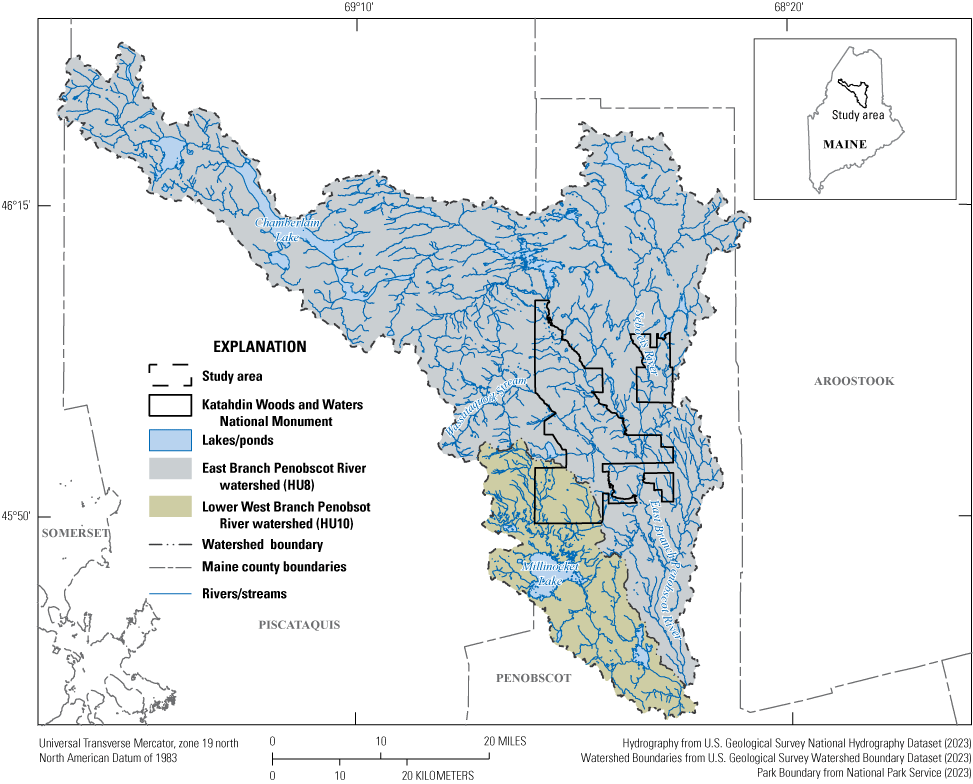
Map showing the study area and Katahdin Woods and Waters National Monument boundary in Maine, including the associated East Branch Penobscot River and Lower West Branch Penobscot River watersheds, rivers/streams, lakes/ponds, and counties. HU, hydrologic unit.
Water-Resources Reports and Datasets
A water-resources inventory of rivers, lakes, streams, and wetlands is classified as a fundamental resource and value priority for KAWW. Fundamental resources and values define the purpose and maintain the significance of a national park or monument. These values are principal considerations during planning and management. Wetland identification and assessment are also considered high priorities (NPS, 2023).
Data included in this report were compiled throughout 2023 and 2024. Detailed information on accessible data is available within the “References Cited” section of this report and in tabular format in appendix 1. Unless otherwise stated, data included in this report were collected in the study area.
Physical Hydrology
Watershed delineation and surface-water and groundwater hydrologic features—including spatial extent and associated attributes—were used to inventory physical hydrology within the study area. These data detail information on KAWW-associated watersheds, rivers and streams, lakes and ponds, wetlands, riparian zones, potential and recorded hydraulic effects, and groundwater resources.
Watersheds
The study area is defined by the East Branch Penobscot River watershed (HU8) and the Lower West Branch Penobscot River watershed (HU10), a subsection of the West Branch Penobscot River watershed (HU8). Delineation of these watersheds and hydrologic unit codes are accessible through the USGS National Watershed Boundary Dataset—a component of the National Hydrography Dataset (NHD) (USGS, 2023). In addition, watershed boundaries for any location on a stream in Maine, including reaches throughout the study area, can be delineated and exported through USGS StreamStats (USGS, 2024b).
Surface Water
Surface water is a defining feature of KAWW (NPS, 2023). Published surface-water hydrologic data in the study area are detailed in the following subsections.
Rivers and Streams
Information pertaining to rivers and streams in KAWW is available from various sources. The USGS NHD provides geospatial datasets that include flow lines and waterbodies (USGS, 2023). In the NHD, natural features such as waterfalls, rapids, and springs are identified. The NHD provides spatial data for 2 springs and 30 waterfalls/rapids in the study area (Wieferich and others, 2020; USGS, 2023). The USFWS Southeast Aquatic Resources Partnership Waterfall Database encompasses seven additional datapoints (USFWS, 2023c). Detailed attributes—including images, descriptions, and habitat data—are available for natural barriers, including 6 waterfalls and 1 beaver dam, in the Maine Stream Habitat Viewer (Maine Department of Inland Fisheries and Wildlife [MDIFW], 2022a, b). Five of these sites are not included in the other databases.
NHD flow lines define the surface water stream network. Typically derived from physical observations of published USGS topographic quadrangles, as well as the U.S. Department of Agriculture Forest Service primary base map series, and supplemented by digital orthophoto quadrangles, the NHD identifies 1,610 miles and 131 named streams and rivers in the study area (USGS, 2023).
An updated stream network developed within the KAWW boundary by using lidar-derived hydrography is available as a USGS data release (Stewart, 2025). The updated stream network utilizes high-quality lidar data from the USGS 3D Elevation Program and the NHD headwater seed points—beginning and end point locations—to provide a more accurate stream network with the same reach length (Stewart, 2025). The lidar-derived hydrography resulted in more accurate streamlines throughout KAWW, as well as 14 additional miles of streams that were not previously delineated as part of the NHD.
Streamflow statistics for any location on a stream reach in Maine, including stream reaches throughout the study area, can be computed through USGS StreamStats (USGS, 2024b). Streamflow statistics that can be computed within the study area by StreamStats include peak streamflows (Lombard and Hodgkins, 2020); monthly and annual mean and 1-, 5-, 10-, 25-, 50-, 75-, 90-, 95-, and 99-percentile streamflows (Dudley, 2015); low 7-day, 10-year streamflows (Dudley, 2004); and base-flow statistics (Lombard and others, 2021). Basin characteristics for basins in the study area, including watershed area, mean and maximum basin elevation, maximum 24-hour rainfall statistics (Parameter-Elevation Regressions on Independent Slopes Model [PRISM] Climate Group, 2012), percentage of land underlain by sand and gravel aquifers (Maine Department of Agriculture, Conservation & Forestry, 2020), and percentage of storage as computed from the USFWS National Wetlands Inventory (NWI) (USFWS, 2023b), can also be computed by using StreamStats.
Detailed information about streamflow monitoring is available in the “Streamgages” subsection of the “Infrastructure Reports and Datasets” section of this report.
Lakes and Ponds
Geospatial information regarding lakes, ponds, and reservoirs is available from the NHD (USGS, 2023) and the NWI (USFWS, 2023b). The NHD combines lakes and ponds into one category, totaling 972 unique points and covering 52,000 acres (USGS, 2023). The NWI contains 274 distinctive lake and 2,394 distinctive pond points, covering a total of 50,000 acres and 2,575 acres, respectively (USFWS, 2023b). Six reservoir points are included in the NHD and constitute a total of 38 acres (USGS, 2023).
Wetlands
The NWI hosts the most comprehensive wetland dataset. These data include polygons of freshwater emergent wetlands and freshwater forested/shrub wetlands; 82,500 acres of wetlands, in the study area, are identified in this dataset. Associated reports are accessible through the NWI mapper (USFWS, 2023b). Wetland maps and descriptive details of wetlands within the KAWW boundary, published before its establishment as a national monument, can be found in DeWolf (2014) and include the following wetlands:
-
• Silver maple floodplain forest
-
• Hardwood river terrace forest
-
• Hardwood seepage forest
-
• Spruce-fir-cinnamon fern forest
-
• Northern white cedar swamp
-
• Cedar-spruce seepage forest
-
• Red maple-sensitive fern swamp
-
• Spruce-larch wooded bog
-
• Sweetgale mixed shrub fen
-
• Alder shrub thicket
-
• Mountain holly-alder woodland fen
-
• Sheep laurel dwarf shrub bog
-
• Leatherleaf boggy fen
-
• River beach
-
• Pickerelweed-macrophyte aquatic bed
-
• Bluejoint meadow
-
• Mixed graminoid-shrub marsh
-
• Cattail marsh
-
• Tussock sedge meadow
-
• Sedge-leatherleaf fen lawn
Additionally, a detailed vegetation map and report, which include shrub wetlands, ruderal mixed herbaceous-shrub wetlands, mixed herbaceous-shrub wetlands, and herbaceous wetlands of the Seboeis Unit of KAWW, are available as a USGS scientific investigations report and a USGS data release (Strassman and others, 2022a, b). The derivation of wetland characteristics is detailed in both of these publications, and it includes color infrared imagery interpretation, physical observations, and a combination of the two methods for the NWI (DeWolf, 2014; Strassman and others, 2022a, b; USFWS, 2023b).
The MDIFW maps and assesses vernal pools and seasonal depression wetlands (MDIFW, 2023b, c). Significant vernal pools, distinguished by identification of endangered or threatened State-listed species or abundance of notable wildlife, and candidate significant vernal pools are documented through physical observations and community identification (Maine Department of Environmental Protection [MDEP], 2009). Sixty-nine total vernal pools have been documented and observed in the study area, 18 of which are considered significant (MDIFW, 2023b, c). Documentation of vernal pools within the KAWW boundary was noted by DeWolf (2014); however, no mapping was performed.
Riparian Areas
Riparian transitional zone spatial data are available within the MDIFW Beginning with Habitat database (MDIFW, 2023a). These data are a standardized, spatially derived 250-foot (ft) buffer applied to ponds (greater than 10 acres), rivers, and wetlands; and a 75-ft-wide buffer applied to streams. No additional information is available within these datasets.
Hydraulics
Flood inundation maps from the 1980s exist for the following towns in the study area: Millinocket, East Millinocket, Medway, and Patten (Federal Emergency Management Agency, 1985–89). Historical ice jam locations and descriptions are recorded and maintained by the U.S. Army Corps of Engineers (USACE) in their “Ice Jams Historic” geospatial file (USACE, 2023). Three ice jams have been recorded in the study area on the East Branch Penobscot River in Grindstone and Medway, dating from 1965 to 2005.
Groundwater
Maine groundwater aquifers generally consist of unconsolidated sand and gravel in the lowlands and fractured bedrock in the uplands. According to the Maine Geological Survey (MGS), sand and gravel aquifers that can support wells with yields of 10 gallons per minute or greater are considered significant sources of water supply. Significant sand and gravel aquifers have been mapped and maintained by the MGS (Maine Department of Agriculture, Conservation & Forestry, 2020). The MGS provides maps delineating aquifer boundaries seismic lines, surficial geology, and surficial material. Publicly accessible data in the study area are limited and are only available west of the KAWW boundary.
Detailed groundwater well information (well type, depth, and yield) is available in the “Wells” subsection of the “Infrastructure Reports and Datasets” section of this report.
Water Quality
Water-quality monitoring has been identified as a fundamental resources and values priority for KAWW (NPS, 2023). Currently (2025), KAWW is not monitoring water quality in the study area. However, historical water-quality monitoring locations, data, and assessments within the study area are listed in the following report section, “Water-Quality Monitoring.”
Water-Quality Monitoring
Water-quality data within the study area have been collected by the Maine Department of Environmental Protection (MDEP), the Penobscot Nation, the USGS, and the U.S. Environmental Protection Agency (EPA). Data collected by these agencies are compiled in the National Water Quality Monitoring Council (NWQMC) Water Quality Portal (NWQMC, 2024). The database includes 252 study area monitoring locations (91 river/stream, 81 lake/reservoir/impoundment, 7 well, 3 wetland) and 4,156 water-quality samples. In some cases, duplicate monitoring location points may exist to distinguish test type or test number. Records date from 1969 to 2022 and include physical and chemical parameters (pH, temperature, specific conductance, and dissolved oxygen), habitat assessments, and biological surveys (counts and tissue sampling). Source locations may include additional details and web applications, such as information sourced from the MDEP Environmental and Geographic Analysis Database (MDEP, 2023a), MDEP Surface Water Ambient Toxics monitoring program (MDEP, 2024b), MDEP Biological Monitoring Program (MDEP, 2023b), USGS Water Data for the Nation (USGS, 2024c), USGS EcoSHEDS (Spatial Hydro-Ecological Data Systems; USGS, 2024a), and EPA National Aquatic Resource Surveys (EPA, 2024b). Predictive analysis of stream temperature is available through the EcoSHEDS Northeast Stream Temperature Model (USGS, 2024a).
The Water Quality Portal is additionally accessible through the EPA Watershed Assessment, Tracking, and Environmental Results System (EPA, 2024e). Attributes of sample data may be evaluated on the EPA’s How’s My Waterway database (EPA, 2024d).
The MDEP has published water-quality study reports on the Seboeis River, the Wassataquoik Stream, and the East Branch Penobscot River (MDEP, 2018, 2019, 2020b). Analyzed data are stored in the Water Quality Portal and MDEP Environmental and Geographic Analysis Database (MDEP, 2023a; NWQMC, 2024).
Impairment Status
States are required to submit biennial reports detailing assessed waters, impaired waters, and restoration efforts (Clean Water Act, 33 U.S.C. 1251 et seq.). Integrated reports are readily available from 2006 to 2022 through the MDEP (MDEP, 2024a). Detailed information and reference sources can be found in the respective Integrated Water Quality Monitoring and Assessment Reports. The EPA Assessment, Total Maximum Daily Load Tracking and Implementation System (ATTAINS) compiles this information into the integrated reporting category score (EPA, 2018). Within the study area, 17 assessments are included in the 2022 ATTAINS report. Impairment is observed on the Millinocket Stream (category score of 4A), the Penobscot River (4B), and the West Branch Penobscot River (4B/4C) (EPA, 2024a). ATTAINS geospatial services are accessible through the EPA Watershed Assessment, Tracking, and Environmental Results System, and detailed information may be available on the EPA How’s My Waterway database (EPA, 2024d, e).
Impairment may additionally be assessed relative to specific risks. Eagles-Smith and others (2020a) evaluate national-scale aquatic ecosystem mercury risk, which includes KAWW. This study utilizes dragonfly larvae total mercury concentrations in relation to fish and amphibian total mercury concentrations at the same site to develop an impairment index. Moderate mercury impairment has been identified in KAWW. Associated data are available in a USGS data release (Eagles-Smith and others, 2020b).
Infrastructure Reports and Datasets
The identification and assessment of hydrologic infrastructure is a high priority for KAWW (NPS, 2023). Infrastructure associated with water resources includes culverts, bridges, dams, well-water withdrawal points, wastewater discharge points, groundwater monitoring well locations, and streamflow-gaging stations.
Stream Crossings
Multiple Federal and State agencies and associated collaborators have compiled and assessed stream crossings throughout the State, including the area within KAWW. Datasets include bridges and culverts and their attributes. Attributes vary depending on the purpose of the dataset.
The USGS identified possible bridge and culvert locations using a geographic information system (GIS). Theoretical stream crossing locations derived through a geospatial analysis of intersecting NDH flow lines and the 2020 U.S. Census Bureau Topologically Integrated Geographic Encoding and Referencing road lines are available in a USGS data release (Wieferich, 2022). This dataset includes 512 potential stream crossings.
The USFWS maintains the most extensive documentation of stream crossings as aquatic barriers assessed for aquatic organism passage. The USFWS National Aquatic Barrier Inventory is a spatial database of local, State, regional, and national data that includes known barriers and an assessment of the constriction and severity of the barriers (USFWS, 2024). Barrier types include bridges, culverts (single and multiple), and fords. Historical crossings, which have been removed, are also included in the database. Inaccessible crossings may be designated as “no crossing” or “unknown.” In total, 674 crossings have been field-surveyed in the study area. Crossings in the study area that are considered severe barriers make up 29 percent of the assessed crossings.
Included in the USFWS National Aquatic Barrier Inventory is the comprehensive statewide inventory and assessment of stream crossings completed by the Maine Department of Marine Resources and associated partners of the Maine Stream Connectivity Working Group. Available through the Maine Stream Habitat Viewer and hosted within the MDIFW Beginning with Habitat database (MDIFW, 2022a, 2023c), this database includes images, potential environmental effects, and habitat considerations not listed by the USFWS. Documentation of 248 surveyed stream crossings, as well as their physical attributes, can be found in this database. The Maine Stream Habitat Viewer is additionally used as the base layer for The Nature Conservancy Culvert Flood Risk Explorer and Aquatic Barrier Prioritization web applications (The Nature Conservancy, 2024). The Culvert Flood Risk Explorer quantifies the risk of culvert failure within next 30 years due to a flood event that exceeds culvert capacity. The Aquatic Barrier Prioritization application identifies critical stream connectivity barriers in relation to priority habitat. Currently (2024), these applications do not contain assessments for barriers within the KAWW boundary.
Crossings that have not been assessed for aquatic organism passage are available through the Federal Highway Administration, the Federal Railroad Administration, and the Maine Department of Transportation (MaineDOT). The Federal Highway Administration inventories structures that meet National Bridge Inspection Standards, and these are included in the National Bridge Inventory System (USDOT, 2023). National Bridge Inventory reporting is required for structures that have an opening width greater than 20 ft. Multiple culverts with distances between openings of less than half of the adjacent opening and with an end-to-end width of 20 ft or more are included (USDOT, 2022b). This database details channel evaluations at the structure location and structure evaluations. National Bridge Inventory structures identified in the study area include 3 culverts and 11 bridges. Channel condition ratings for these structures range from very good to poor, with three structures being classified as “fair” or “poor.” One railroad bridge crossing is included in this dataset; however, a more comprehensive list of railroad bridges is available through the Federal Railroad Administration Railroad Bridges geospatial layer (USDOT, 2022a). This geospatial layer includes 10 railroad bridges in the study area. Physical attributes are included for some of the railroad bridges but are not comprehensive.
Public bridges and stream crossings associated with State-owned roadways in the study area are maintained by the MaineDOT. The MaineDOT database categorizes roadway structures as bridges, large culverts, or cross culverts (MaineDOT, 2021a, b, 2023). Structures with a cross-sectional opening from 20 to 80 square feet (ft2) or a span greater than 5 ft and less than 10 ft are considered large culverts in this database. Structures that exceed these dimensions are classified as “bridges.” Those that do not meet the minimum requirements of large culverts are documented as cross culverts. A number of culverts that are not connected to a waterway are included in this database and are likely storm drains, runoff controls, or similar features. There is no attribute within this dataset to easily identify these disconnected culverts. Thirty-two bridges, 7 large culverts, and 254 cross culverts have been assessed and identified by the MaineDOT in the study area. All datasets include documentation of structure dimensions and materials. Bridges are evaluated, where applicable, for the following: deck, superstructure, substructure, culvert, channel flow, and scour. Major to severe damage to the stream channel has been reported on five of the bridges. The general condition of culverts ranges from critical to good. Cross culverts with a rating of fair, poor, or critical make up 20 percent of the recorded data. A critical rating was designated for one of the large culverts, and the remaining were rated in good or fair condition.
Dams
Datasets of dams in the study area include the USACE National Inventory of Dams (NID), the USFWS National Aquatic Barrier Inventory, and the MDEP Dam, Levees, Impoundments, and Barriers database (MDEP, 2022; USACE, 2022; USFWS, 2023a). The USFWS National Aquatic Barrier Inventory and MDEP datasets use the NID as a base layer. Dams featured in the USFWS National Aquatic Barrier Inventory are a compilation of the NID and MDEP datasets with a focus on aquatic organism habitat fragmentation (USFWS, 2023a). In total, 14 active dams are identified. The NID database includes attributes such as dimensions, materials, maximum storage and discharge, hazard potential, and condition assessment for the 14 dams (USACE, 2022). The NID maintains data for regulated dams that are active. Four dams in this dataset are classified as “high hazard” (Grand Lake [Matagamon] Dam, Stone Dam—Dike 8, Dolby Dam, and Millinocket Lake Dam), and two are in poor condition (Grand Lake [Matagamon] Dam and Telos Dam). The MDEP database contains current and historical dam locations (MDEP, 2022). Two additional removed dams (Swift Brook Dam and Upper Shin Dam) are included in the MDEP dataset. This dataset is referenced in the Maine Stream Habitat Viewer and associated applications (MDIFW, 2022a).
Wastewater Discharge
Under the Federal Clean Water Act, the EPA requires a National Pollutant Discharge Elimination System (NPDES) permit for point source discharge into U.S. waters (Clean Water Act, 33 U.S.C. 1251 et seq.). NPDES permit information is available through the EPA Facility Registry Service (EPA, 2024c) and is additionally accessible on the EPA Watershed Assessment, Tracking, and Environmental Results System and the EPA How’s My Waterway database (EPA, 2024d, e). MDEP has regulatory authority to administer NPDES permits and maintains a separate database, the Maine Pollutant Discharge Elimination System (MDEP, 2020a, 2021). Five active and four inactive point source contamination sites are recorded within the study area. All sites are listed as major facilities that outfall in either the Millinocket Stream, Ferguson Pond, or the West Branch Penobscot River in Millinocket (MDEP, 2020a). Twenty-seven additional, nonmajor facility sites are listed in the NPDES within the study area. Permits from these sites include industrial stormwater, combined sewer overflow, biosolids, publicly owned treatment waters, and major, nonmajor, and unpermitted outfall sites. In total, 80 permits have been documented, with 77 expired, terminated, or administratively continued (permit not reissued) and 3 considered effective (EPA, 2024c).
Wells
The Water Well Information Law of 1987 (Maine Legislature, 2003) requires drilling companies to report detailed operations to the MGS. As such, comprehensive statewide well data are available through the MGS Water Well Database (Maine Department of Agriculture, Conservation & Forestry, 2023). This database contains data collected through the mandatory reporting required by the Water Wells Information Law of 1987, data obtained through an initial information request from well drillers in the 1970s, and data from a voluntary reporting program in the mid-1980s. This database features well depth, yield, and overburden thickness. Wells drilled before 1987 may not be included in this database. Wells reported to MGS with unknown spatial data are maintained in a separate dataset titled “MGS Wells Unlocated,” which accounts for 36 percent of the total wells in Maine. The MGS Water Well Database documents 97 wells in the study area (Maine Department of Agriculture, Conservation & Forestry, 2023). Additional water-quality information for domestic wells may be available through the MDEP Environmental and Geographic Analysis Database; however, when assessed (2023), no information was available in this database within the study area (MDEP, 2023a). There are no active USGS groundwater wells in the study area; however, six inactive USGS groundwater well sites contain discrete historical data (collected in 1988): USGS 453831068331101 PEW 579, USGS 454057068420701 PEW 582, USGS 453949068381101 PEW 583, USGS 454602068344601 PEW 584, USGS 455550068364301 PEW 585, and USGS 455753068370301 PEW 586 (USGS, 2024c).
Streamgages
Three USGS streamflow-gaging stations are active in the study area; the East Branch Penobscot River below Grand Lake Matagamon (USGS site 01029100), the East Branch Penobscot River at Grindstone (USGS site 01029500), and the Seboeis River near Shin Pond (USGS site 01029200). Streamflow data include continuous discharge measurements and periodic discrete water-quality and physical measurements. East Branch Penobscot River below Grand Lake Matagamon additionally measures instantaneous air and water temperature. Continuous streamflow data have been monitored since 1998 at the East Branch Penobscot River at Grindstone and the Seboeis River near Shin Pond; the East Branch Penobscot River below Grand Lake Matagamon has been monitored since May 2024 (USGS, 2024c).
Assessment of Existing Data
An extensive summary of priority management concerns for KAWW can be found in the KAWW foundation document (NPS, 2023). Previous sections of this report detail a range of publicly accessible datasets and reports in relation to the fundamental resources and values of a water-resources inventory and assessment for KAWW; however, these data may encompass various other needs documented by KAWW. A brief assessment of gaps in the publicly accessible data follows.
Hydrography in KAWW is relatively comprehensive; however, most of the data were derived through a GIS, and differences in the same feature exist between datasets. Surveyed and ground-truth data are relatively limited. Detailed wetland data are primarily available within the KAWW boundary; however, these data are noncomprehensive in the remaining study area. Datasets that include vernal pool spatial information within KAWW were not found. Detailed riparian transitional zone information and stream classification (in terms of perennial, intermittent, and ephemeral) were not found. Detailed aquifer maps are not available in the study area west of Millinocket.
Lidar-derived hydrography improved the delineation of streams within the KAWW boundary that were previously identified by the NHD. Unidentified tributaries by the NHD and flow lines that extend past the KAWW boundary remain unevaluated. To complete the delineation of hydrography in the study area, the remaining flow lines in the East Branch Penobscot River Basin (HU8) and Lower West Branch Penobscot River Basin (HU10) would require lidar-derived hydrography, as detailed by Stewart (2025). The unidentified flow lines, not available in the NHD, would require further processing, which could be achieved through a USGS 3D Hydrography Program level project. This project would need to include additional, detailed specifications of elevation data preparation and hydrography data acquisition (USGS, 2025).
A water-quality monitoring network does not currently (2025) exist within KAWW. Water quality in KAWW has been documented sporadically since 1969 and is limited, especially on smaller streams (NWQMC, 2024). Eight monitoring locations have been documented within the KAWW boundary. This includes 7 sites on 4 different rivers or streams (Katahdin Stream, Wassataquoik Stream, Seboeis River, and Ragged Brook) and 1 inactive well site (USGS-455550068364301) (NWQMC, 2024; USGS, 2024c). In the study area, water-quality information within the East Branch Penobscot River System is also limited. Outside the KAWW boundary 4, 5, and 22 additional unique monitoring locations on or near the Seboeis River, the Wassataquoik Stream, and the East Branch Penobscot River, respectively, have been documented (NWQMC, 2024). The current status of these water-quality monitoring stations is unknown. Concerns regarding stream temperature and nutrient level, in relation to salmon growth, have been documented on the East Branch Penobscot River System (MDEP, 2018, 2019, 2020b). USGS streamgage 01029100—East Branch Penobscot River below Grand Lake Matagamon—currently has the only continuous instantaneous stream temperature data available within the study area. Additionally, water-quality impairment has been noted on the Penobscot River, the Millinocket Stream, and the West Branch Penobscot River (EPA, 2024a).
Infrastructure data related to water resources are more comprehensive than water-resources data but also include significant data gaps. Stream crossing surveys focus on structures that cross over streams and rivers and their relation to fisheries. Twenty-nine percent of assessed crossings within the study area are classified as “severe barriers”; 33 of these are within the KAWW boundary (USFWS, 2024). Potential stream crossings tallies, documented by Wieferich (2022), do not account for stream crossing intersections on trails and roads that are not included in the U.S. Census Bureau’s geographic spatial data. These data document 54 potential crossings in the KAWW boundary, underestimating the potential crossings by at least 79 points when compared to the USFWS National Aquatic Barrier Inventory, which includes 133 stream crossings (USFWS, 2024; Wieferich, 2022). Additional points may be those identified on roads not included in the U.S. Census Bureau geographic spatial data; however, over 600 structures have been suggested to exist within KAWW (S.M. Wimmer, National Park Service, oral commun., 2024), leaving over 450 crossings unaccounted for in public data. Unaccounted-for structures may be those used for drainage and not connected to waterways. The MaineDOT includes drainage culverts on public roads; however, because the roads within the KAWW boundary are not public, the MaineDOT does not survey and manage these structures.
Two dams in the study area are in poor condition (Grand Lake [Matagamon] Dam and Telos Dam), and four are classified as “high hazard” (Grand Lake [Matagamon] Dam, Stone Dam—Dike 8, Dolby Dam, and Millinocket Lake Dam) (USACE, 2022). These dams are not within the KAWW boundary; however, the Telos Dam and Grand Lake (Matagamon) Dam are upstream from KAWW. The Telos Dam is over 30 miles upstream in the headwaters of the East Branch Penobscot River, and the Grand Lake (Matagamon) Dam is on the East Branch Penobscot River approximately 3 miles upstream from the KAWW boundary. Historical information on removed dams is largely unknown.
Information regarding wastewater discharge is limited and outdated. Three USGS streamflow-gaging stations within the study area continuously monitor streamflow; however, the Wassataquoik Stream remains unmonitored (USGS, 2024c). The Wassataquoik Stream is priority salmon habitat (MDIFW, 2023a) and hosts recreational trails that ford the stream and campgrounds along its banks. There are many streams that do not have any streamflow data.
Summary
The U.S. Geological Survey, in cooperation with the National Park Service, assessed currently available (2024) published and publicly accessible data and reports to establish a water-resources inventory and assessment for Katahdin Woods and Waters National Monument (KAWW). The results of this work may be used by natural resource managers to protect surface water and groundwater, biological communities, and cultural resources. This report includes published and publicly accessible information on water quantity, water quality, and hydrologic infrastructure and identifies major gaps within the data.
Limitations of current datasets in relation to KAWW include incomplete groundwater, streamflow, wetland, and water-quality data. This documentation of water-resources and infrastructure data within KAWW and contributing drainage basins can help KAWW water resource managers identify data gaps and take the next steps toward developing water-quality and water-quantity monitoring plans to safeguard the habitat and waters it protects.
References Cited
DeWolf, B., 2014, East of Katahdin—Ecological survey of the East Branch Properties of Elliotsville Plantation, Inc., Penobscot County Maine: Digital Maine, prepared by Elliotsville Plantation, Inc., Portland, Maine, [variously paged; 222 p.], accessed March 2, 2023, at https://digitalmaine.com/elliotsville_plantation_inc_docs/2.
Dudley, R.W., 2004, Estimating monthly, annual, and low 7-day, 10-year streamflows for ungaged rivers in Maine: U.S. Geological Survey Scientific Investigations Report 2004–5026, 22 p., accessed April 3, 2025, at https://doi.org/10.3133/sir20045026.
Dudley, R.W., 2015, Regression equations for monthly and annual mean and selected percentile streamflows for ungaged rivers in Maine (ver. 1.1, December 21, 2015): U.S. Geological Survey Scientific Investigations Report 2015–5151, 35 p., accessed April 3, 2025, at https://doi.org/10.3133/sir20155151.
Eagles-Smith, C.A., Willacker, J.J., Nelson, S.J., Flanagan Pritz, C.M., Krabbenhoft, D.P., Chen, C.Y., Ackerman, J.T., Grant, E.H.C., and Pilliod, D.S., 2020a, A national-scale assessment of mercury bioaccumulation in United States national parks using dragonfly larvae as biosentinels through a citizen-science framework: Environmental Science & Technology, v. 54, no. 14, p. 8779–8790, accessed June 1, 2023, at https://doi.org/10.1021/acs.est.0c01255.
Eagles-Smith, C.A., Willacker, J.J., Jr., Nelson, S.J., Flanagan-Pritz, C.M., Krabbenhoft, D.P., Chen, C.Y., Ackerman, J.T., Grant, E.H.C., and Pilliod, D.S., 2020b, Mercury bioaccumulation in US national parks using dragonfly larvae as biosentinels, 2009–2018: U.S. Geological Survey data release, accessed June 1, 2023, at https://doi.org/10.5066/P9T2FRU3.
Federal Emergency Management Agency, 1985–89, Flood insurance studies, Towns of Millinocket, East Millinocket, Medway, Patten, Maine: Washington, D.C., Federal Emergency Management Agency, accessed May 8, 2024, at https://msc.fema.gov/portal/search.
Lombard, P.J., Dudley, R.W., Collins, M.J., Saunders, R., and Atkinson, E., 2021, Model estimated baseflow for streams with endangered Atlantic Salmon in Maine, USA: River Research and Applications, v. 37, no. 9, p. 1254–1264, accessed April 3, 2025, at https://doi.org/10.1002/rra.3835.
Lombard, P.J., and Hodgkins, G.A., 2020, Estimating flood magnitude and frequency on gaged and ungaged streams in Maine: U.S. Geological Survey Scientific Investigations Report 2020–5092, 56 p., accessed April 3, 2025, at https://doi.org/10.3133/sir20205092.
Maine Department of Agriculture, Conservation & Forestry, 2020, Significant sand and gravel aquifer maps—Digital data: Maine Geological Survey, accessed May 30, 2024, at https://www.maine.gov/dacf/mgs/pubs/digital/aquifers.htm.
Maine Department of Agriculture, Conservation & Forestry, 2023, Water well database: Maine Geological Survey database, accessed April 29, 2023, at https://www.maine.gov/dacf/mgs/pubs/digital/well.htm.
Maine Department of Environmental Protection [MDEP], 2009, Vernal pools—A significant wildlife habitat (fact sheet): Maine Department of Environmental Protection web page, accessed October 23, 2024, at https://www.maine.gov/dep/land/nrpa/vernalpools/fs-vernal_pools_intro.html.
Maine Department of Environmental Protection [MDEP], 2018, Water quality in the Upper East Branch Penobscot River: Maine Department of Environmental Protection report, 8 p., accessed June 1, 2023, at https://www.maine.gov/dep/water/monitoring/rivers_and_streams/salmon/water-quailty-upper-east-branch-penobscot-river.pdf.
Maine Department of Environmental Protection [MDEP], 2019, Water quality in Wassataquoik stream: Maine Department of Environmental Protection report, 16 p., accessed June 1, 2023, at https://www1.maine.gov/dep/water/monitoring/rivers_and_streams/salmon/water-quality-in-wassataquoik-stream.pdf.
Maine Department of Environmental Protection [MDEP], 2020a, MaineDEP pollutant discharge elimination system outfall: Maine Department of Environmental Protection dataset, accessed March 16, 2023, at https://maine.hub.arcgis.com/maps/maine::mainedep-pollutant-discharge-elimination-system-outfall/about.
Maine Department of Environmental Protection [MDEP], 2020b, Water quality in Seboeis River: Maine Department of Environmental Protection report, 15 p., accessed June 1, 2023, at https://www.maine.gov/dep/water/monitoring/rivers_and_streams/salmon/seboeis-report-february2020.pdf.
Maine Department of Environmental Protection [MDEP], 2021, General permit for the discharge of stormwater from Maine Department of Transportation and Maine Turnpike Authority Municipal Separate Storm Sewer Systems—General Permit: Maine Department of Environmental Protection MER043000, [variously paged; 132 p.], accessed October 10, 2024, at https://www3.epa.gov/region1/npdes/permits/2021/finalmer043000permit.pdf.
Maine Department of Environmental Protection [MDEP], 2022, Maine dams, levees, impoundments, and barriers 2022: Maine Department of Environmental Protection dataset, accessed November 14, 2023, at https://maine.hub.arcgis.com/maps/42548401c6ad4bbda82af0b82bb3e607/explore?location=45.750568%2C-68.846346%2C12.45.
Maine Department of Environmental Protection [MDEP], 2023a, Environmental and geographic analysis database: Maine Department of Environmental Protection web page, accessed December 1, 2023, at https://www.maine.gov/dep/maps-data/egad/index.html.
Maine Department of Environmental Protection [MDEP], 2023b, The Maine DEP Biological Monitoring Program—Biomonitoring sites: Maine Department of Environmental Protection dataset, accessed March 16, 2023, at https://maine.maps.arcgis.com/apps/webappviewer/index.html?id=8752837d17a64017a84769539ef810a6.
Maine Department of Environmental Protection [MDEP], 2024a, Integrated water quality monitoring and assessment reports: Maine Department of Environmental Protection web page, accessed May 8, 2024, at https://www.maine.gov/dep/water/monitoring/305b/index.html.
Maine Department of Environmental Protection [MDEP], 2024b, Surface water ambient toxics monitoring program (SWAT): Maine Department of Environmental Protection web page, accessed May 8, 2024, at https://www.maine.gov/dep/water/monitoring/toxics/swat/index.html.
Maine Department of Inland Fisheries and Wildlife [MDIFW], 2022a, Maine Stream Habitat Viewer: State of Maine, accessed October 11, 2023, at https://maine.hub.arcgis.com/maps/e49409f5571a46ef8380876b497c95c2/about.
Maine Department of Inland Fisheries and Wildlife [MDIFW], 2022b, Natural Barriers—Maine Stream Habitat Viewer: State of Maine dataset, accessed May 17, 2023, at https://maine.hub.arcgis.com/datasets/maine::maine-stream-habitat-viewer/about?layer=2.
Maine Department of Inland Fisheries and Wildlife [MDIFW], 2023a, Beginning with habitat maps—Interactive map viewer, digital data, accessed June 7, 2023, at https://www.maine.gov/ifw/fish-wildlife/wildlife/beginning-with-habitat/maps/index.html.
Maine Department of Inland Fisheries and Wildlife [MDIFW], 2023b, Significant vernal pools: Maine Department of Inland Fisheries and Wildlife web page, accessed March 16, 2023, at https://mdifw-data-maine.hub.arcgis.com/datasets/maine::significant-vernal-pools/about.
Maine Department of Inland Fisheries and Wildlife [MDIFW], 2023c, Vernal pool centerpoints: Maine Department of Inland Fisheries and Wildlife web page, accessed March 16, 2023, at https://mdifw-data-maine.hub.arcgis.com/datasets/maine::vernal-pool-centerpoints/about.
Maine Department of Transportation [MaineDOT], 2021a, MaineDOT cross culverts: Maine Department of Transportation software release, accessed March 16, 2023, at https://maine.hub.arcgis.com/datasets/617d6f95e3e947d7a0d8985ddfc028e9_54/explore.
Maine Department of Transportation [MaineDOT], 2021b, MaineDOT large culverts: Maine Department of Transportation software release, accessed March 16, 2023, at https://maine.hub.arcgis.com/datasets/05e65c5a43da4f2ab29b88fb33c20a4b/explore.
Maine Department of Transportation [MaineDOT], 2023, MaineDOT bridges: Maine Department of Transportation software release, accessed March 16, 2023, at https://maine.maps.arcgis.com/home/item.html?id=5c884800d36a44c1872ee7e5f195245f.
Maine Legislature, 2003, Water well information, title 12, pt. 2, chap. 201–B, §550–B: Maine Legislature, accessed March 16, 2024, at https://www.mainelegislature.org/legis/statutes/12/title12sec550-B.html.
National Park Service [NPS], 2023, Foundation document—Katahdin Woods and Waters National Monument: National Park Service report, 40 p. accessed April 14, 2024, at https://www.nps.gov/kaww/getinvolved/upload/KAWW_FD_508_2023-0224.pdf.
National Water Quality Monitoring Council [NWQMC], 2024, Water quality portal: National Water Quality Monitoring Council, accessed May 6, 2024, at https://www.waterqualitydata.us/.
Parameter-Elevation Regressions on Independent Slopes Model (PRISM) Climate Group, 2012, United States average monthly or annual precipitation, 1981–2010, 30 arc-second normal, created July 10, 2012: Oregon State University, PRISM Climate Group web page, accessed September 16, 2013, at http://www.prism.oregonstate.edu/.
Stewart, B.E., 2025, Lidar-derived hydrography of Katahdin Woods and Waters National Monument, Maine, 2023: U.S. Geological Survey data release, https://doi.org/10.5066/P94QSSSP.
Strassman, A.C., Hop, K.D., Sattler, S.R., Schlawin, J., and Cameron, D., 2022a, Vegetation map for the Seboeis Unit of Katahdin Woods and Waters National Monument: U.S. Geological Survey Scientific Investigations Report 2022–5078, 73 p., accessed June 1, 2023, at https://doi.org/10.3133/sir20225078.
Strassman, A.C., Sattler, S.R., Hop, K.D., Ruhser, J., Schlawin, J., and Cameron, D., 2022b, Vegetation map for the Seboeis Unit of Katahdin Woods and Waters National Monument (vector and tabular data): U.S. Geological Survey data release, accessed June 1, 2023, at https://doi.org/10.5066/P93HGWGB.
The Nature Conservancy, 2024, TNC Maine mapping portal: The Nature Conservancy web page, accessed April 24, 2024, at https://www.maps.tnc.org/maine/.
U.S. Army Corps of Engineers [USACE], 2022, National Inventory of Dams—NID: U.S. Army Corps of Engineers web page, accessed April 26, 2024, at https://www.arcgis.com/home/item.html?id=1632cb2bb23046569fbf2bc144f06764.
U.S. Army Corps of Engineers [USACE], 2023, Ice James Historic: U.S. Army Corps of Engineers geospatial database, accessed November 24, 2023, at https://geospatial-usace.opendata.arcgis.com/datasets/84e7f2e5d37b45268ea5618ae4cf1809_0/about.
U.S. Department of Transportation [USDOT], 2022a, Railroad bridges: U.S. Department of Transportation web page, accessed April 24, 2024, at https://data.transportation.gov/Railroads/Railroad-Bridges/bvag-c3cn/about_data.
U.S. Department of Transportation [USDOT], 2022b, Specifications for the National Bridge Inventory: U.S. Department of Transportation, Federal Highway Administration, Office of Bridges and Structures publication FHWA–HIF–22–017, 335 p., accessed April 29, 2024, at https://www.fhwa.dot.gov/bridge/snbi/snbi_march_2022_publication.pdf.
U.S. Department of Transportation [USDOT], 2023, National Bridge Inventory (NBI) System: U.S. Department of Transportation web page, accessed April 29, 2024, at https://data.transportation.gov/Roadways-and-Bridges/National-Bridge-Inventory-System-NBI-/uack-gist/about_data.
U.S. Environmental Protection Agency [EPA], 2018, EPA integrated reporting (IR) categories and how ATTAINS calculates them (ver. 8/31/2018): U.S. Environmental Protection Agency document, 4 p., accessed July 9, 2024, at https://www.epa.gov/sites/default/files/2018-09/documents/attains_calculations_of_epa_ir_categories_2018-08-31.pdf.
U.S. Environmental Protection Agency [EPA], 2024a, ATTAINS Assessments: U.S. Environmental Protection Agency dataset, accessed May 2, 2024, at https://www.epa.gov/waterdata/waters-geospatial-data-downloads#NationalGeospatialDatasets.
U.S. Environmental Protection Agency [EPA], 2024b, Data from the national aquatic resource surveys: U.S. Environmental Protection Agency web page, accessed May 8, 2024, at https://www.epa.gov/national-aquatic-resource-surveys/data-national-aquatic-resource-surveys.
U.S. Environmental Protection Agency [EPA], 2024c, EPA facility registry service—National pollutant discharge elimination system sites: U.S. Environmental Protection Agency web page, accessed April 29, 2024, at https://hub.arcgis.com/datasets/EPA::epa-facility-registry-service-national-pollutant-discharge-elimination-system-sites-npdes/about.
U.S. Environmental Protection Agency [EPA], 2024d, How’s my waterway database: U.S. Environmental Protection Agency web page, accessed May 2, 2024, at https://mywaterway.epa.gov/.
U.S. Environmental Protection Agency [EPA], 2024e, Watershed assessment, tracking, and environmental results systems, WATERS GeoViewer 2.0: U.S. Environmental Protection Agency database, accessed May 2, 2024, at https://epa.maps.arcgis.com/apps/webappviewer/index.html?id=074cfede236341b6a1e03779c2bd0692.
U.S. Fish and Wildlife Service [USFWS], 2023a, Dams—National aquatic barrier inventory June 2024—Dams 10/18/2023: U.S. Fish and Wildlife Service database, accessed November 24, 2023, at https://gis-fws.opendata.arcgis.com/datasets/fws::national-aquatic-barrier-inventory-dams-oct182023/about.
U.S. Fish and Wildlife Service [USFWS], 2023b, National Wetlands Inventory surface waters and wetlands: U.S. Fish and Wildlife Service software release, accessed November 11, 2023, at https://fwsprimary.wim.usgs.gov/wetlands/apps/wetlands-mapper/.
U.S. Fish and Wildlife Service [USFWS], 2023c, SARP Waterfall Database 01212020: U.S. Fish and Wildlife Service software release, accessed November 24, 2023, at https://gis-fws.opendata.arcgis.com/datasets/fws::sarp-waterfall-database-01212020/about.
U.S. Fish and Wildlife Service [USFWS], 2024, All RoadBarriers 01212019: U.S. Fish and Wildlife Service software release, accessed April 22, 2024, at https://gis-fws.opendata.arcgis.com/datasets/fws::all-roadbarriers-01212019/about.
U.S. Fish and Wildlife Service [USFWS] and National Marine Fisheries Service [NMFS], 2018, Recovery plan for the Gulf of Maine distinct population segment of Atlantic salmon (Salmo salar): U.S. Fish and Wildlife Service and National Marine Fisheries Service, accessed February 13, 2025, at https://atlanticsalmonrestoration.org/resources/documents/atlantic-salmon-recovery-plan-2015.
U.S. Geological Survey [USGS], 2023, National Geospatial Program, 20231117, USGS National Hydrography Dataset best resolution (NHD) for hydrological unit (HU) 4 - 0102 (published 20231117) FileGDB: U.S. Geological Survey dataset, accessed October 17, 2023, at https://www.sciencebase.gov/catalog/item/61f8b9e2d34e622189c32b68.
U.S. Geological Survey [USGS], 2024a, EcoSHEDS Databases, models, and data visualization tools for understanding freshwater ecosystems: U.S. Geological Survey web page, assessed May 8, 2024, at https://www.usgs.gov/apps/ecosheds/#/.
U.S. Geological Survey [USGS], 2024b, StreamStats: U.S. Geological Survey software release, accessed April 4, 2024, at https://streamstats.usgs.gov/ss/.
U.S. Geological Survey [USGS], 2024c, USGS water data for the Nation: U.S. Geological Survey National Water Information System database, accessed May 20, 2024, at https://doi.org/10.5066/F7P55KJN.
U.S. Geological Survey [USGS], 2025, Elevation-derived hydrography data acquisition specifications—Table of contents: U.S. Geological Survey web page, accessed April 4, 2025, at https://www.usgs.gov/ngp-standards-and-specifications/elevation-derived-hydrography-data-acquisition-specifications.
U.S. Office of the Federal Register, 2009, Endangered and threatened species; determination of endangered status for the Gulf of Maine distinct population segment of Atlantic salmon, final rule: Federal Register, v. 117, p. 29344–29387, accessed February 13, 2025, at https://federalregister.gov/a/E9-14269.
Wieferich, D.J., 2022, Database of stream crossings in the United States: U.S. Geological Survey data release, accessed April 22, 2024, at https://doi.org/10.5066/P9YX6KTB.
Wieferich, D.J., Daniel, W.M., Procopio, J.M., and Morningstar, C.R., 2020, Waterfalls and rapids in the conterminous United States linked to the National Hydrography Datasets V2.0: U.S. Geological Survey data release, accessed April 29, 2024, at https://doi.org/10.5066/P9QQTKA0.
Appendix 1. References Cited, by Water-Resource or Infrastructure Type
Table 1.1.
References cited, by water-resource or infrastructure type.[USGS, U.S. Geological Survey; USFWS, U.S. Fish and Wildlife Service; EPA, U.S. Environmental Protection Agency; MDIFW, Maine Department of Inland Fisheries and Wildlife; NWQMC, National Water Quality Monitoring Council; MDEP, Maine Department of Environmental Protection; FEMA, Federal Emergency Management Agency; USACE, U.S. Army Corps of Engineers; MGS, Maine Geological Survey; MDACF, Maine Department of Agriculture, Conservation & Forestry; TNC, The Nature Conservancy; USDOT, U.S. Department of Transportation; MaineDOT, Maine Department of Transportation]
| Type | Inventory and mapping | Water quantity | Water quality |
|---|---|---|---|
| Watersheds | National Hydrography Dataset (USGS, 2023) StreamStats (USGS, 2024b) |
Not applicable | Not applicable |
| Rivers and streams | National Hydrography Dataset (USGS, 2023) Waterfalls and Rapids in the Conterminous United States Linked to the National Hydrography Datasets V2 (Wieferich and others, 2020) USFWS Southeast Aquatic Resources Partnership Waterfall Database (USFWS, 2023c) Maine Stream Habitat Viewer (MDIFW, 2022a, b1) Lidar-derived hydrography (Stewart, 2025) |
StreamStats (USGS, 2024b) USGS Water Data for the Nation (USGS, 2024c)2 |
National Water Quality Monitoring Council Water Quality Portal (NWQMC, 2024)3 Maine Environmental and Geographic Analysis Database (MDEP, 2023a)3 Maine Surface Water Ambient Toxics Monitoring Program (MDEP, 2024b)3 MDEP Biological Monitoring Program (MDEP, 2023b)3 USGS Water Data for the Nation (USGS, 2024c)2,3 USGS EcoSHEDs (USGS, 2024a)3 National Aquatic Resource Survey (EPA, 2024b)3 Watershed Assessment, Tracking, and Environmental Results System (EPA, 2024e)3,4 How’s My Waterway database (EPA, 2024c)3,4 Water Quality in the Seboeis River Report (MDEP, 2020b)3 Water Quality in the Wassataquoik Stream Report (MDEP, 2019)3 Water Quality in the Upper East Branch Penobscot River Report (2018)3 Maine Integrated Water Quality Monitoring and Assessment Reports (MDEP, 2024a)4 EPA Assessment, Total Maximum Daily Load Tracking and Implementation System (EPA, 2024a)4 Mercury Bioaccumulation in US National Parks Using Dragonfly Larvae as Biosentinels, 2009–2018, report and data release (Eagles-Smith and others, 2020a, b)4 |
| Lakes and ponds | National Hydrography Dataset (USGS, 2023) National Wetlands Inventory (USFWS, 2023b) |
Not applicable | National Water Quality Monitoring Council Water Quality Portal (NWQMC, 2024)3 Maine Environmental and Geographic Analysis Database (MDEP, 2023a)3 Maine Surface Water Ambient Toxics Monitoring Program (MDEP, 2024b)3 MDEP Biological Monitoring Program (MDEP, 2023b) USGS EcoSHEDs (USGS, 2024a)3 National Aquatic Resource Survey (EPA, 2024b)3 Watershed Assessment, Tracking, and Environmental Results System (EPA, 2024e)3,4 How’s My Waterway database (EPA, 2024c)3,4 Maine Integrated Water Quality Monitoring and Assessment Reports (MDEP, 2024a)4 EPA Assessment, Total Maximum Daily Load Tracking and Implementation System (EPA, 2024a)4 Mercury Bioaccumulation in US National Parks Using Dragonfly Larvae as Biosentinels, 2009–2018, report and data release (Eagles-Smith and others, 2020a, b)4 |
| Wetlands | National Wetland Inventory (USFWS, 2023b) East of Katahdin: ecological survey report (DeWolf, 2014)5 Vegetation Map for the Seboeis Unit of Katahdin Woods and Waters National Monument report and data release (Strassman and others, 2022a, b) Vernal Pool Center Points (MDIFW, 2023c)1 Significant Vernal Pools (MDIFW, 2023b)1 |
Not applicable | National Water Quality Monitoring Council Water Quality Portal (NWQMC, 2024)3 Maine Environmental and Geographic Analysis Database (MDEP, 2023a)3 Maine Surface Water Ambient Toxics Monitoring Program (MDEP, 2024b)3 Watershed Assessment, Tracking, and Environmental Results System (EPA, 2024e)3,4 How’s My Waterway database (EPA, 2024c)3,4 EPA Assessment, Total Maximum Daily Load Tracking and Implementation System (EPA, 2024a)4 |
| Riparian areas | Beginning With Habitat Maps (MDIFW, 2023a) | Not applicable | Not applicable |
| Hydraulics | Flood Insurance Studies (FEMA, 1985–89)6 Ice Jam Historical Geospatial Data (USACE, 2023) |
USGS Water Data for the Nation (USGS, 2024c)2 | Not applicable |
| Groundwater | Significant Sand and Gravel Aquifer Maps (Maine Department of Agriculture, Conservation & Forestry, 2020) Water Well Database (MDACF, 2023) |
Water Well Database (MDACF, 2023) | National Water Quality Monitoring Council Water Quality Portal (NWQMC, 2024)3 Environmental and Geographic Analysis Database (MDEP, 2023a)3,7 USGS Water Data for the Nation (USGS, 2024c)3,8,9 |
| Stream crossings | Potential Stream Crossing Locations (Wieferich, 2022) National Aquatic Barrier Inventory (USFWS, 2024)10 Maine Stream Habitat Viewer (MDIFW, 2022a, 2023c)10 Culvert Flood Risk Explorer web application (TNC, 2024)1,10 Aquatic Barrier Prioritization web application (TNC, 2024)1,10 National Bridge Inventory System (USDOT, 2023)1 Federal Railroad Administration Railroad Bridges (USDOT, 2022a)1 State Managed/Owned Bridges (MaineDOT, 2023)1 State Managed/Owned Culverts (MaineDOT, 2021a, b)1 |
Not applicable | Not applicable |
| Dams | National Inventory of Dams (USACE, 2022)1 National Aquatic Barrier Inventory (USFWS, 2023a)1 MDEP Dams, Levees, Impoundments, Barriers database (MDEP, 2022)1 Maine Stream Habitat Viewer (MDIFW, 2022ba)1 |
Not applicable | Not applicable |
| Wastewater discharge | National Pollutant Discharge Elimination System Sites (EPA 2024b, c, e)1 MDEP Pollutant Discharge Elimination System Outfall (MDEP, 2020a)1 |
Not applicable | Not applicable |
Three U.S. Geological Survey (USGS) streamflow-gaging stations: the East Branch Penobscot River below Grand Lake Matagamon (01029100), the East Branch Penobscot River at Grindstone, Maine (01029500), and the Seboeis River near Shin Pond, Maine (01029200).
Mentioned in the “Water-Quality Monitoring” section of this report.
Mentioned in the “Impairment Status” section of this report.
Flood-insurance studies are available for Millinocket, East Millinocket, Medway, and Patten, Maine.
USGS streamflow-gaging station: the East Branch Penobscot River below Grand Lake Matagamon (01029100).
Datums
Vertical coordinate information is referenced to the North American Vertical Datum of 1988 (NAVD 88).
Horizontal coordinate information is referenced to the North American Datum of 1983 (NAD 83).
Abbreviations
EPA
U.S. Environmental Protection Agency
GIS
geographic information system
HU
hydrologic unit
KAWW
Katahdin Woods and Waters National Monument
MaineDOT
Maine Department of Transportation
MDEP
Maine Department of Environmental Protection
MDIFW
Maine Department of Inland Fisheries and Wildlife
MGS
Maine Geological Survey
NHD
National Hydrography Dataset
NID
National Inventory of Dams [U.S. Army Corps of Engineers]
NPDES
National Pollutant Discharge Elimination System
NWI
National Wetlands Inventory [U.S. Fish and Wildlife Service]
NWQMC
National Water Quality Monitoring Council
PRISM
Parameter-Elevation Regressions on Independent Slopes Model
USACE
U.S. Army Corps of Engineers
USDOT
U.S. Department of Transportation
USFWS
U.S. Fish and Wildlife Service
USGS
U.S. Geological Survey
For more information about this report, contact:
Director, New England Water Science Center
U.S. Geological Survey
10 Bearfoot Road
Northborough, MA 01532
dc_nweng@usgs.gov
or visit our website at
Disclaimers
Any use of trade, firm, or product names is for descriptive purposes only and does not imply endorsement by the U.S. Government.
Although this information product, for the most part, is in the public domain, it also may contain copyrighted materials as noted in the text. Permission to reproduce copyrighted items must be secured from the copyright owner.
Suggested Citation
Tudor, A.L., 2025, Water-resources inventory and assessment at Katahdin Woods and Waters National Monument: U.S. Geological Survey Scientific Investigations Report 2025–5070, 16 p., https://doi.org/10.3133/sir20255070.
ISSN: 2328-0328 (online)
Study Area
| Publication type | Report |
|---|---|
| Publication Subtype | USGS Numbered Series |
| Title | Water-resources inventory and assessment at Katahdin Woods and Waters National Monument |
| Series title | Scientific Investigations Report |
| Series number | 2025-5070 |
| DOI | 10.3133/sir20255070 |
| Publication Date | August 07, 2025 |
| Year Published | 2025 |
| Language | English |
| Publisher | U.S. Geological Survey |
| Publisher location | Reston, VA |
| Contributing office(s) | New England Water Science Center |
| Description | Report: vi, 16 p.; Data Release |
| Country | United States |
| State | Maine |
| Other Geospatial | Katahdin Woods and Waters National Monument |
| Online Only (Y/N) | Y |
| Additional Online Files (Y/N) | N |