

Groundwater Budget for the Mountain Home Area, Southern Idaho, 2022–23
Links
- Document: Report (4.8 MB pdf) , HTML , XML
- Data Release: USGS data release - Supporting data for 2022–2023 groundwater budget for the Mountain Home area, southern Idaho
- NGMDB Index Page: National Geologic Map Database Index Page (html)
- Download citation as: RIS | Dublin Core
Acknowledgments
The author would like to express their appreciation for the invaluable technical insights, engaging discussions, and constructive feedback generously provided by the following individuals: A. Steimke, C. Tesch, D. Owsley, A. Vincent, K. Smith, and B. Ragan of the Idaho Department of Water Resources; S. Hundt, L. Zinsser, and S. Ducar of the U.S. Geological Survey; R. Thomas of The Academy of Natural Sciences of Drexel University; and the Mountain Home Irrigation District.
Abstract
The U.S. Geological Survey, with funding from the Idaho Department of Water Resources, developed a groundwater budget for the Mountain Home area in southern Idaho for irrigation year 2023 (November 1, 2022–October 31, 2023). This study focused on the water balance across the Cinder Cone Butte Critical Groundwater Area (CGWA), Mountain Home Groundwater Management Area (GWMA), and the rest of the study area (RoSA), compiling data from various sources, including precipitation records, groundwater level measurements, metered groundwater pumpage data, surface water diversions and evapotranspiration (ET) estimates derived from remote sensing satellite imagery, and ground-based reference data. Key inflow components included recharge from applied surface water irrigation (which incorporates incidental recharge from irrigation practices and conveyance losses), estimated tributary streamflow, and estimated mountain block recharge. The key outflow components were groundwater pumpage for irrigation, municipal, industrial, and domestic uses, and ET. Recharge from applied irrigation and mountain block recharge were the largest inflows, and groundwater pumpage for irrigation was the largest outflow.
The CGWA had a positive groundwater budget residual of 2,170 acre-feet (acre-ft), which contrasts with observed long-term groundwater level declines and historical trends of storage depletion. This positive residual is likely associated with unquantified outflows, including lateral groundwater flow out of the subregion, or other complexities, such as overestimated tributary contributions relative to the actual recharge for the 2023 water budget. The GWMA exhibited a positive residual of 56,563 acre-ft, primarily owing to recharge from applied surface water irrigation and areal recharge during a wetter-than-average year, which allowed irrigation entities to deliver more water from in-basin and out-of-basin reservoirs. The RoSA showed a large positive residual of 124,933 acre-ft. The interpretation of these positive residuals must account for significant uncertainties, including estimations of areal recharge, tributary streamflow (particularly losses and diversions), ET, the volume of surface water loss to the Snake River, lateral groundwater flows between subregions and across study area boundaries, and the unquantified groundwater discharge to the Snake River. These uncertainties, in combination with the complex hydrogeologic controls on water movement and limitations of remotely sensed data, directly affect the accuracy of water availability assessments.
Future data collection efforts would help reduce these uncertainties and support water resource management decisions in the Mountain Home area. Key efforts could include installing additional streamflow gaging stations (particularly to quantify tributary losses and gains and surface water losses to the Snake River), improving groundwater pumpage metering, and validating remotely sensed ET data with ground-based measurements. Furthermore, to better quantify unrepresented or highly uncertain fluxes, focused investigations on groundwater discharge to the Snake River, lateral groundwater flows between subregions and across study area boundaries, and a more robust determination of the actual influence and volume of mountain block recharge would help refine future water availability assessments for the Mountain Home area.
Introduction
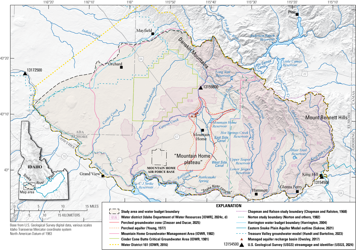
This report quantifies and evaluates the groundwater budget for irrigation year 2023 (November 1, 2022–October 31, 2023) for the Mountain Home area (also referred to as the “study area”) in southern Idaho, situated within the Snake River Plain (fig. 1). This analysis, conducted by the U.S. Geological Survey (USGS) in cooperation with the Idaho Department of Water Resources (IDWR), is part of a broader USGS hydrogeologic investigation (Zinsser and Ducar, 2025). Groundwater levels have declined in the region since the early 1960s, prompting the IDWR to establish the Cinder Cone Butte Critical Groundwater Area (CGWA) in the western part of the study area in 1981, followed by the designation of Mountain Home Groundwater Management Area (GWMA) in 1982 (fig. 1; IDWR, 1981, 1982). A critical groundwater area designation applies to areas where groundwater is insufficient to meet existing withdrawal rates, whereas a groundwater management area designation applies to areas approaching critical conditions, where new water appropriations require demonstration of sufficient supply without affecting prior water rights (Idaho Legislature, 2024). In response to continued concerns about groundwater availability and sustainability, IDWR commissioned the USGS to conduct this study to evaluate current groundwater conditions and develop a comprehensive water budget for the region.
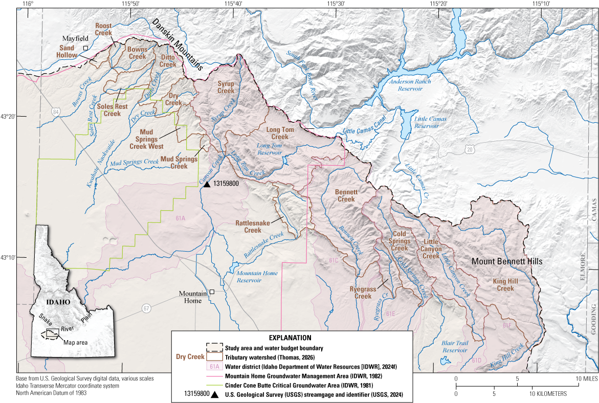
Map showing the location of the study area in the Mountain Home area, southern Idaho.
Groundwater levels in the CGWA have declined by as much as 125 feet (ft) since the 1960s, whereas those in the GWMA, where the City of Mountain Home is located, have been relatively stable except for some declines along the southern boundary (SPF Water Engineering, LLC, 2017). Levels at the Mountain Home Air Force Base (MHAFB) have declined approximately 50 ft within the same timeframe (1960s to present), prompting the MHAFB and the State of Idaho to seek a more sustainable water supply for the base. The MHAFB currently relies on groundwater wells to meet potable water supply demand. To enhance water supply resilience and reduce the Air Force base’s dependence on groundwater, the Idaho Water Resource Board secured Snake River water rights for a pipeline system capable of delivering up to 3.5 million gallons per day (Mgal/d) to the MHAFB (SPF Water Engineering, LLC, 2017; IDWR, 2023, 2024e). In areas around and between the MHAFB and the CGWA, levels have declined as much as 100 ft, whereas levels in areas near the Snake River in the rest of the study area (RoSA) were stable or minimally fluctuating (SPF Water Engineering, LLC, 2017; USGS, 2024; Zinsser and Ducar, 2025).
In response to continued groundwater level decline and to improve hydrogeologic understanding of the region, the IDWR drilled five new monitoring wells in 2024 and assisted the USGS in a groundwater level synoptic survey in the spring (March) and fall (November) of 2023, encompassing 182 existing wells throughout the study area (Zinsser and Ducar, 2025, fig. 13). The dataset from the 2023 synoptic survey provides a basis for comparison and analysis, which is used to help inform storage change in comparison to values documented for this report.
The population of the City of Mountain Home, the study area’s largest population center, has increased by approximately 17 percent from 2010 to 2023 (14,206 to 16,703), exceeding SPF Water Engineering, LLC’s (2017) projections, and is expected to continue increasing owing to the city’s proximity to the expanding Boise metropolitan area (U.S. Department of Agriculture National Agricultural Statistics Service, 2023). This combination of increasing population, declining groundwater levels, and the need for sustainable water resources resulted in the need for an updated groundwater budget and hydrogeologic investigation for the Mountain Home area.
Purpose and Scope
This report aims to provide a contemporary assessment of water resource use and availability within the study area by quantifying and evaluating the region’s groundwater budget for irrigation year 2023. Irrigation year 2023 was selected to align with the groundwater synoptic survey conducted as part of the hydrogeologic framework (Zinsser and Ducar, 2025), facilitating comparisons with calculations of storage changes and accompanying groundwater level change maps. The year was also chosen because it was recent, ensuring the availability of pumping and other relevant data.
A groundwater budget is a quantitative assessment of the inflows, outflows, and changes in storage within an aquifer or aquifer system over a specific period. In this report, estimates of these components are derived from existing data. Inflows are defined to include precipitation, tributary watershed streamflow and groundwater contributions, and incidental recharge from agricultural, domestic, and municipal sources. Outflows encompass withdrawals for various purposes, including domestic, municipal, agricultural, and industrial operations. Uncertainties and limitations associated with these estimates are also highlighted throughout the report.
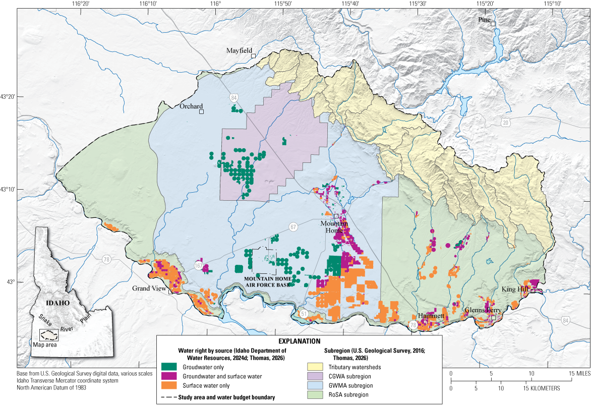
The geographic scope of this study encompasses the Mountain Home area, which includes both urban and rural environments. Although the regional aquifer system, composed of specific geologic formations, extends beyond this area, the analysis concentrates on the hydrogeologic controls within the Mountain Home area. For clarity in reporting groundwater budget results, the study area is divided into three primary subregions: the CGWA, GWMA, and RoSA. Additionally, tributary watersheds are delineated as a separate contributing subregion to the water budget (fig. 2). These regions were selected to emphasize the inflows and outflows related to the designated management areas and areas situated between two existing groundwater flow models (Sukow, 2021; Hundt and Bartolino, 2023).
Map showing irrigated lands (intersected with water-right place of use), water budget subregions, and contributing tributary watersheds, Mountain Home area, southern Idaho. [CGWA, Cinder Cone Butte Critical Groundwater Area; GWMA, Mountain Home Groundwater Management Area; RoSA, rest of the study area]
Given the ongoing growth of the City of Mountain Home and regional concerns regarding aquifer depletion, this updated assessment of water resources aims to provide an analysis of groundwater and surface water inflows and outflows across the selected regions and an updated understanding of water resource dynamics within the Mountain Home area along with highlighting areas of uncertainty where additional information could help refine future water budget analyses.
Previous Work
Analysis of surface and groundwater resources in the Mountain Home area began in the late 1950s. Since then, numerous studies have contributed to the understanding of the region’s hydrogeology (table 1), including Chapman and Ralston (1968, 1970), Young (1977), Norton and others (1982), Harrington (2004), Tesch (2013), SPF Water Engineering, LLC (2017), and the most recent investigation by Zinsser and Ducar (2025).
Table 1.
Previous water balance investigations that took place in the Mountain Home area, southern Idaho, and resulting water budget residuals.[CGWA, Critical Groundwater Area; GWMA, Groundwater Management Area; n.r., not reported]
| Investigation | Study period | Study extent | Water budget residuals1 (acre-foot per year) |
|---|---|---|---|
| Chapman and Ralston (1968) | 1967 | Study area2,3 | n.r. |
| Chapman and Ralston (1970) | 1969 | Partial GWMA and CGWA | n.r. |
| Young (1977) | 1976 | Study area2,3 | n.r. |
| Norton and others (1982) | 1980 | CGWA and GWMA | −600 |
| Harrington (2004) | 1998 | CGWA and GWMA | −30,900 |
| Tesch (2013) | 2012 | CGWA | −9,400 |
A negative residual in the groundwater budget signifies a deficit (outputs exceeding inputs), and a positive residual indicates a surplus (inputs exceeding outputs). Refer to the “Previous Work” section for further explanation.
Shown in figure 1.
Early investigations conducted by Chapman and Ralston (1968, 1970) covered most of the area included in this present investigation (refer to the “Description of Study Area” for more information) and laid an important foundation prior to extensive groundwater resource development in the area. These studies employed field measurements and hydrogeological assessments to evaluate groundwater levels and quality, indicating that increasing development was beginning to affect “hot artesian groundwater resources” near the Mount Bennett Hills and highlighted the sensitivity of the artesian system to proposed limited recharge rates. Although varying hydrogeological conditions across the study area resulted in varying rates of groundwater withdrawals, the lack of prior recorded groundwater levels at the time precluded the observation of any significant aquifer depletion (Chapman and Ralston, 1968, 1970).
As groundwater development progressed in subsequent years, Young's (1977) assessment of the City of Mountain Home, the MHAFB, and the desert expanse to the west-northwest towards Boise warned that further development could exacerbate declines in water levels, particularly to the south and west of the City of Mountain Home (fig. 1). Young (1977) estimated a natural discharge of approximately 18,000 acre-feet (acre-ft) from the groundwater system but did not compile recharge estimates or total withdrawal figures during this investigation. These three studies primarily addressed regional hydrogeology, groundwater levels, and groundwater quality, but did not expand on the inflow and outflow components related to regional water budget analyses (Chapman and Ralston, 1968, 1970; Young, 1977).
In 1982, Norton and others (1982) produced a more comprehensive analysis of the overall water budget for the Mountain Home area, focusing on the 1980 irrigation year covering an area roughly the spatial extent of the GWMA (fig. 1). Norton and others (1982) calculated the total crop irrigation requirement (CIR) from water-right data, estimating the water supply needed to meet the CIR at 78,000 acre-ft. This figure included both groundwater and surface water sources and a residual of −600 acre-ft (table 1), indicating a small net overdraft (Norton and others, 1982). Norton and others (1982) predated the installation of a streamgage at Canyon Creek at Oregon Trail Crossing Near Mountain Home (USGS 13159800; hereafter, “the Canyon Creek streamgage”; fig. 1), relying instead on relationships among precipitation volumes, drainage elevation, and area, in addition to a limited number of flow measurements.
As shown in figure 1, Harrington (2004) covered a similar extent to Norton and others (1982), using satellite imagery and updated methodologies for estimating evapotranspiration (ET) volumes to calculate a water balance showing a source-less use (inflows minus outflows and consumptive use) deficit of −30,900 acre-ft. Their analysis involved remote sensing techniques to assess land use and irrigation practices, although it did not account for acreage irrigated by pumped Snake River water, which was included in Norton and others’ (1982) investigation. If the acreage irrigated by pumped Snake River water had been included in Harrington’s (2004) analysis, it is likely that their results would have aligned more closely with those of Norton and others (1982). This inclusion would have potentially reduced the source less use deficit, resulting in a smaller residual in the water budget, similar to what Norton and others (1982) calculated.
More recent investigations have provided additional analyses indicating the continued decrease of water levels in the CGWA and other portions of the study area. Tesch (2013) reported a deficit for the CGWA of approximately −9,400 acre-ft, using aerial imagery to determine actively irrigated lands and employing ET estimations based on known crop types. Additionally, a 2017 report by SPF Water Engineering, LLC, compiled for Elmore County, assessed annual deficits for the CGWA, the City of Mountain Home, and the MHAFB as −24,000 acre-ft, −7,000 acre-ft, and −12,000 acre-ft, respectively, using a broader water rights approach to determine irrigated acreage and associated CIR volumes (SPF Water Engineering, LLC, 2017).
Description of Study Area
The Mountain Home area, located in the high-desert environment of southern Idaho, has vast expanses of sagebrush habitat and localized agriculture and is adorned with volcanic structures, such as cinder cones and shield volcanoes, and descends subtly toward the southwest. Its southern boundary is defined by the Snake River Canyon (fig. 1). Lands below the canyon rim are outside the bounds of the GWMA and CGWA and therefore not included in those water budget calculations. However, they are included in the water budget for the RoSA outside of the GWMA.
In addition to the CGWA and GWMA, the study area includes five surface water districts (61A, 61C, 61E, 61D, and 61F) and one groundwater district (161). These water districts (fig. 1) are organized governmental entities created and supervised by the IDWR to manage surface water distribution based on water-right records. Groundwater District 161 (fig. 1) has similar responsibilities for the administration and oversight of groundwater rights (IDWR, 1981, 1982, 2016).
The eastern boundary of the study area coincides with the natural drainage of the plateau (fig. 1). The western boundary is a combination of hydrologic drainage divide, administrative boundary, and the addition of the Idaho Army National Guard (IDARNG) base area southwest of Orchard, Idaho (fig. 1). The northern boundary is formed by the Danskin Mountains and Mount Bennett Hills, with two significant peaks reaching elevations of 6,693 ft and 7,447 ft, respectively. This boundary effectively represents the drainage divide of the respective tributary watersheds at their highest elevations. This study area extent was also chosen to fill in the areas between existing groundwater-flow models (Eastern Snake Plain Aquifer Model and Treasure Valley Groundwater Flow Model; fig. 1). The southern boundary is located where the study area meets the Snake River.
Population centers consist of the City of Mountain Home (largest), which is in the central study area, followed by other outlying population centers such as the MHAFB to the southwest and Hammett and the City of Glenns Ferry to the southeast. The Danskin Mountains and Mount Bennett Hills lie to the north-northeast of all major population centers (fig. 1).
Land Use
The study area encompasses approximately 893,230 acres, roughly one-fifth (164,200 acres) of which comprises the tributary watersheds. The remaining area is primarily non-irrigated rangeland, as designated in the IDWR irrigated lands raster (IDWR, 2024b) for irrigation year 2023 (fig. 2), alongside the vast expanse of desert lands depicted in the figure’s background imagery.
To identify irrigated areas, the IDWR employed a supervised machine learning algorithm known as random forest. This approach uses various satellite-based inputs, data from the U.S. Department of Agriculture (USDA) National Agriculture Imagery Program, and active water-right place of use (POU) data from IDWR to delineate areas of active irrigation (IDWR, 2024b). The resulting dataset classifies land as either irrigated or non-irrigated. The analysis identified approximately 830,430 acres as non-irrigated, and 62,800 acres were designated as irrigated within the study area boundary (fig. 2).
It is important to note that, for future spatial calculations based on irrigated lands, some agricultural acreage situated just southwest of the boundary of the CGWA (fig. 2) was included in the overall calculations for the CGWA rather than being designated as part of the GWMA. This inclusion is based on the fact that the water rights for this acreage are associated with larger holdings within the CGWA (IDWR, 2024c, d, h).
Land use and water rights play a crucial role in understanding the source and allocation of water for various agricultural, municipal, domestic, and industrial operations. The study area is supplied by both groundwater and surface water, as illustrated in figure 2. Geospatial information from water-right POU, provided by the IDWR (2024d), guided the identification of unique source and mixed-use irrigated areas, and were categorized into three distinct types based on their documented point of diversion and POU: groundwater-only, surface-water-only, and mixed-use areas where both sources are used (Thomas, 2026).
Hydrogeologic Setting
The Mountain Home area lies within the western Snake River Plain and has experienced multiple volcanic events, the surface expressions of which can still be seen today in the form of exposed flows and vents and lacustrine, alluvial, and fluvial depositional environments, which have all been affected by regional tectonics (Lewis and others, 2012). The bounding mountain ranges, which form the northeasterly uplands, are made up of Cretaceous granitic rocks of the Idaho Batholith on the northwestern part of the range and Tertiary rhyolite and basalt on the southeastern segment (Lewis and others, 2012; Zinsser and Ducar, 2025). Surface water in the study area predominantly flows from the upland Danksin Mountains and Mount Bennett Hills, moving southwest and south via a combination of ephemeral and perennial streams toward the Snake River, which flows generally from east to west along the southern boundary of the study area.
Groundwater
A considerable amount of hydrogeologic research has been conducted over the decades. Chapman and Ralston (1968) identified key aquifers within the Glenns Ferry (lake and stream sediments) and Bruneau (basalt and sediments) Formations, establishing a foundation for understanding perched groundwater zones and the regional aquifer system. Notably, Young (1977) documented declining groundwater levels in the Cinder Cone Butte area, which provided the first detailed spatial delineation of perched groundwater zones, along with highlighting the Bruneau Formation as the most productive aquifer in the region. Whereas previous studies focused on formation-based aquifer designations (Zinsser and Ducar, 2025), shifts to a lithology and hydraulic property-based approach. Hydrogeologic units are defined by their dominant lithology and associated hydraulic properties (for example, coarse-grained sediments, fine-grained sediments, and basalt) to provide a more consistent and regionally applicable hydrogeologic framework. In this framework, the regional aquifer is described as hosted within basalt and fine-grained sediment hydrogeologic units (Zinsser and Ducar, 2025).
Groundwater generally flows southward from the higher elevations of the northern foothills, discharging into the Snake River (Chapman and Ralston, 1968; Newton, 1991; Wood and others, 2014; Zinsser and Ducar, 2025). The hydraulic gradient varies geographically: it is steeper in the north, becomes flatter south of the City of Mountain Home and the CGWA, and then steepens again as it nears the Snake River Canyon (fig 1). Zinsser and Ducar (2025) found that despite seasonal shifts in water levels, the primary regional flow direction remained generally toward the south between spring and autumn 2023.
Faulting can have significant effects on groundwater occurrence and movement. Although certain faults have been systematically mapped through geological and geophysical surveys (Lewis and others, 2012; Liberty, 2012; Welhan, 2012; Nielson and Shervais, 2014), the locations and hydrological effects of others remain largely inferred. Evidence for these unmapped faults is supported by notable differences in groundwater levels among adjacent wells and evidence of displacement of water-bearing units along Interstate 84 through the CGWA, as interpreted during the groundwater level synoptic and updated hydrogeologic framework of Zinsser and Ducar (2025).
Faults can either impede or facilitate groundwater flow. For instance, the steepened groundwater gradients along the range front, combined with geochemical evidence, suggest deep groundwater recharge along faults in the Mayfield area (Welhan, 2012; Hopkins, 2013). Additionally, several deep wells in the eastern study area exhibit artesian geothermal conditions, likely influenced by faulted silicic-volcanic rocks (Castelin, 1993; Lewis and others, 2012; Zinsser and Ducar, 2025). However, the extent to which these deep geothermal waters contribute to regional aquifer recharge remains uncertain and is not a focus of this study.
Perched groundwater conditions are present in the areas within and surrounding the City of Mountain Home, initially mapped by Young (1977). The extent of the perched layer has since been updated by Zinsser and Ducar (2025). Changes in its spatial distribution are illustrated in figure 1. Originally characterized as perched in unconsolidated sediments, it is now believed to be predominantly located within basalt formations and some shallow unconsolidated sediments (Zinsser and Ducar, 2025). Inflows to the perched groundwater in the area are thought to be coming from precipitation, streams, and incidental recharge owing to irrigation practices, delivery losses, and contributions from Mountain Home Reservoir seepage (Norton and others, 1982). Within this groundwater budget investigation, the perched and regional aquifers are not differentiated when accounting for inflows and outflows.
Depth to groundwater varies throughout the Mountain Home area, ranging from seasonally artesian conditions in the southeast associated with deep wells, to near-surface levels in gravels within the perched system in the City of Mountain Home, extending to depths of 300 to 500 ft in the CGWA. Groundwater extraction below the Snake River Canyon rim for irrigation purposes is minimal because the majority of agricultural demands are met with water pumped directly from the Snake River (Norton and others, 1982; SPF Water Engineering, LLC, 2017; IDWR, 2024c, d; Zinsser and Ducar, 2025).
Surface Water
Streamflow serves as an important source of water for agricultural practices in arid regions, where reliable water availability is essential for crop production (Young, 1977). In Idaho, natural waterways, such as streams and rivers, were the original sources for irrigation. Modern turbine groundwater pumps only became prevalent in the 1950s. This historical reliance on surface water continues to shape how these resources are accessed and managed today. Water rights, based on the principle of prior appropriation, play a crucial role in determining the availability of streamflow for irrigation and other uses (Idaho Legislature, 2024). In the study area, reliance on mountain streamflow is an important source of water for those who do not have access to water from the Snake River (Zinsser and Ducar, 2025).
Limited recorded flow data exist for these tributary streams. At the time of publication, the only gaged creek was Canyon Creek (USGS 13159800; USGS, 2024). Canyon Creek is formed by the confluence of Syrup Creek and Long Tom Creek and is supplemented by imported waters from Little Camas Reservoir, conveyed through the Little Camas Canal (fig. 1). Imported water from Little Camas Reservoir, combined with flows from Rattlesnake Creek, is diverted into Mountain Home Reservoir. Any surplus subsequently flows along Canyon Creek to the Snake River. Two canal systems, the East Canal and the West Canal, are used in and around Mountain Home to distribute irrigation water from Mountain Home Reservoir and Canyon Creek to local irrigators.
Within the GWMA, several irrigation districts (fig. 2) own water rights that permit the extraction of Snake River water, which is then pumped up approximately 500 ft in elevation for distribution south of the City of Mountain Home. In addition to these irrigators, those located below the Snake River Canyon rim, from the southern edge of the study area in the south-southwest, upstream to King Hill, Idaho, also possess water rights for using Snake River water (IDWR, 2024c, d). Irrigators along tributary streams typically source their water from these streams or supplement their supplies with groundwater. In addition to the large reservoirs in the area, such as the Mountain Home, Blair Trail, Long Tom, and Little Camas Reservoirs, there are some comparatively smaller reservoirs, like Morrow Reservoir near the City of Glenns Ferry and Walker Reservoir near King Hill (fig. 1). These smaller reservoirs are usually operated by private land holdings or are part of the irrigation strategy of water districts.
Groundwater Budget
The groundwater budget for the Mountain Home study area is developed by quantifying the movement of water into and out of the regional aquifer system. This analysis begins with an assessment of climate variables, specifically precipitation and evapotranspiration, which serve as the primary drivers for natural water availability. These variables are then used to calculate total inflows, which include natural recharge from tributary watersheds and incidental recharge from agricultural, domestic, and potable water sources. Outflows are then accounted for, primarily consisting of groundwater discharge and anthropogenic withdrawals for agricultural and industrial operations. By comparing these components, the report derives a budget residual and evaluates it against observed changes in groundwater storage to characterize the aquifer’s response to these stresses. The following sections detail these components and the uncertainties associated with their estimation.
This analytical approach is based on the principle of mass balance, where the change in storage is equal to the difference between total inflows and total outflows. This relationship is exemplified by the following equation for irrigation year 2023, with all components reported in acre-feet:
whereΔS
is the change in storage of the observed region or study area as a whole,
Qinflow
is the estimated total of all positive inflows into the aquifer, and
Qoutflow
is the estimated total of all losses from the aquifer.
In practice, though, there are errors and assumptions associated with all components within a groundwater budget, and as such, the following adjustment to equation 1 is needed to reflect a practical equation that includes these various uncertainties:
whereR
is the groundwater budget residual, which reflects the net change in groundwater storage and the sum of all associated errors and assumptions;
εassumptions
is the error associated with methodology, or simplification of complex components of the natural system;
εdata
is the error resulting from inaccuracies or limitations in the measured input and output data;
εtemporal
is the error that arises from simplifying continuous changes in water fluxes and storage over time through discrete measurements or averaging; and
εomissions
is the error that occurs when relevant inflows, outflows, or storage changes within the system boundaries are not accounted for, contributing to the unexplained residual.
In this study, inflows to the groundwater system are represented by the following equation and associated components for each non-tributary watershed subregion (CGWA, GWMA, and RoSA):
(3)
Qinflow_estimated
is the total estimated inflow to each non-tributary subregion’s aquifers,
Qmfr
is the surface component of mountain front recharge, representing direct infiltration and shallow subsurface flow from streams and runoff at the mountain-lowland interface into the lowland aquifer;
Qmbr
is the deep subsurface component of mountain front recharge, also known as mountain block recharge, and is the groundwater inflow from the fractured bedrock of the mountain block into the adjacent lowland aquifer;
Qaerial recharge
is the inflow of water to the aquifer from precipitation after ET is subtracted;
Qinf runoff
is the inflow of water from infiltrated runoff;
Qirr losses
is the inflow to the aquifer from losses during irrigation water conveyance and application (sourced from surface water or groundwater diversions), occurring after ET demands are met;
QMAR
represents the volume of water that is intentionally added to the groundwater system through specific human-engineered activities (managed aquifer recharge) to enhance groundwater resources;
QMuni
represents the volume of water that unintentionally infiltrates into the ground and recharges the groundwater system owing to municipal activities and infrastructure;
QDom
is the volume of water that infiltrates into the ground and recharges the groundwater system from domestic wastewater disposal systems, primarily septic systems;
Qgw external
is the volume of groundwater that flows into the boundaries of the study area from adjacent hydrogeologic units or regions; and
Qgw subregions
is the groundwater inflow from one subregion into another.
Outflows from the study area and the three non-tributary subregions are defined as follows:
(4)
QAgpump
is aquifer outflow caused by pumping for agricultural purposes;
QDompump
is aquifer outflow caused by pumping for domestic purposes;
QMunipump
is aquifer outflow caused by pumping for municipal purposes;
QLivestockpump
is aquifer outflow caused by pumping for livestock purposes, considering returns from settling ponds and incidental recharge from operations;
QSnakeRivgw
is groundwater outflow from the study area to the Snake River;
Qgwtooutside
is groundwater lost to adjacent aquifers outside of the study area; and
Qgwtoothersubbasins
is the movement and loss of groundwater between the non-tributary subregions within the study area.
A subset of the estimated inflow and outflow components defined in equations 3 and 4 was reorganized to formulate the practical groundwater budget used in this study, which is summarized by equation 5. This rearrangement reflects not only the measurable components of the system but also incorporates the conceptual structure of equation 2, recognizing that the residual includes the cumulative effects of assumptions, data limitations, temporal averaging, and potential omissions (ε_assumptions, ε_data, ε_temporal, and ε_omissions)
(5)
Equation 5 represents known values and how omitted unknown values affect the final residual. Inflows include estimated streamflow seepage loss, areal recharge from precipitation, and the recharge associated with applied water, particularly from irrigation practices. Streamflow seepage is treated as an inflow component (minus diversions and estimated outflow to the Snake River). Outflows represent the withdrawal and consumption of groundwater resources. This includes groundwater pumpage for agricultural irrigation, domestic use, and municipal supply, alongside consumptive use related to domestic and municipal activities.
By quantifying these inflows and outflows, as presented and explained in subsequent sections of this report and summarized in figure 3 and table 2, this investigation aims to provide an assessment of the groundwater budget for the study area over a one-year period. This investigation describes the interaction between natural hydrologic components and human activities, characterizing the overall groundwater dynamics and their role within the broader regional water balance. While the budget residual represents inherent uncertainties, this analysis is intended to support evaluation of water management practices and inform future resource planning. These uncertainties are discussed in greater detail in subsequent sections.
Table 2.
Water budget for irrigation year 2023 comparing inflows and outflows within the Mountain Home area, southern Idaho.[Data are from Thomas (2026) and Idaho Department of Water Resources (2023a). All values are given in acre-feet. An irrigation year is the 12-month period from November 1 through October 31 of the following year and is designated by the calendar year in which it ends. CGWA, Critical Groundwater Area; GWMA, Groundwater Management Area; RoSA, rest of the study area ; undet., undetermined]
Diversions and surface water loss to the Snake River are accounted for in each subregion’s “Recharge from Tributary Watersheds” volumes.
Streamflow loss to the Snake River based on historical data with outliers removed. Refer to the “Recharge from Tributary Watersheds” section for methodology.
The residuals are large owing to limited data and assumptions regarding the budget components. For more information, refer to the following sections: “Budget Components,” “Groundwater Budget Residuals,” “Changes in Groundwater Storage,” “Groundwater Discharge to Snake River,” and “Uncertainty and Errors in the Groundwater Budget.”
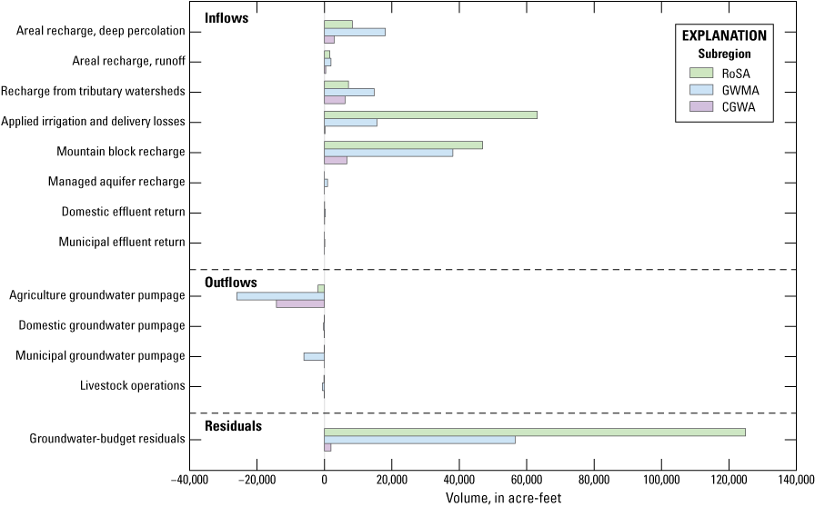
Bar graph of the inflows, outflows, and overall groundwater residuals (including change in storage, budget component uncertainty and errors, along with groundwater discharge to the Snake River) from the irrigation year 2023 water budget for the Mountain Home area, southern Idaho. Data are from Thomas (2026). An irrigation year is the 12-month period from November 1 through October 31 of the following year and is designated by the calendar year in which it ends. [CGWA, Cinder Cone Butte Critical Groundwater Area; GWMA, Mountain Home Groundwater Management Area; RoSA, rest of the study area]
Climate
The study area encompasses two general climatic regimes: an arid, lower-elevation zone, which includes the CGWA, GWMA, and RoSA, and a higher-elevation upland tributary watershed characterized by high-desert mountain conditions (fig. 2). These regimes have a large control on the inflows and outflows presented in this water budget. Precipitation is primarily seasonal, concentrated during the winter months (November through March) as snowfall at higher elevations and rainfall at lower elevations. Additional precipitation occurs in the autumn (September–October) and spring (April–May). For irrigation year 2023, precipitation levels ranged from near-normal to 119 percent of the 30-year irrigation year average (fig. 4; table 3; Abatzoglou, 2011, undated). Understanding the patterns of ET and precipitation is crucial because these factors underlie many components of water budgets (Healy and others, 2007). The specific methods used to calculate ET and precipitation for this water budget are described in the following sections.
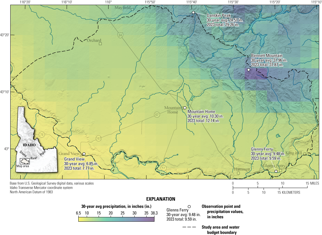
Map showing the average annual precipitation levels for irrigation years 1993–2022 (30-year average [avg]) and the total precipitation for irrigation year 2023 at select observation points, Mountain Home area, southern Idaho. Precipitation volumes estimated from gridMET (Abatzoglou, 2011, undated). An irrigation year is the 12-month period from November 1 through October 31 of the following year and is designated by the calendar year in which it ends.
Table 3.
Comparison of the average annual precipitation levels for irrigation years 1993–2022 (30-year average) and irrigation year 2023 for the Mountain Home area, southern Idaho.[Precipitation volumes were estimated from gridMET (Abatzoglou, 2011, undated). Volumes were originally reported in milliliters. An irrigation year is the 12-month period from November 1 through October 31 of the following year and is designated by the calendar year in which it ends. in., inch; SD, standard deviation]
Precipitation
Estimated precipitation is a foundational component of a water budget, influencing the CIR, available streamflow, and areal recharge. The primary source of precipitation data for this water budget was the gridMET dataset (Abatzoglou, 2011, undated), an acquired dataset providing daily meteorological information for the continental United States for irrigation year 2023. Data from local weather stations were compared to gridMET data to validate the data’s accuracy. Total precipitation accumulation was highest at elevated locations, specifically near Bennett Mountain, which received an estimated 37.9 inches during irrigation year 2023 (fig. 4).
Method
gridMET precipitation volumes were spatially summed over irrigated and non-irrigated lands. Non-irrigated lands are further divided into those within the tributary watershed boundaries (fig. 2) and those outside. This distinction is crucial: tributary precipitation contributes to streamflow generation and recharge of the tributary mountain aquifers while precipitation in non-tributary areas is significant for areal recharge and meeting the CIR, which informs agricultural water use.
To ensure a representative precipitation volume extraction from gridMET 4-kilometer rasters, a weighted average approach was employed using the ExactExtract Python library (Baston, 2023). Traditional zonal statistics methods, which assign the entire cell value of a raster to a polygon if its centroid falls within the polygon's boundary, can lead to inaccurate estimations, particularly when polygons are large or raster cell sizes are coarse. Using a weighted average calculation method, as implemented in packages like ExactExtract (Baston, 2023), yields a more representative estimation by accounting for the proportion of each cell covered by the polygon (Baston, 2023).
Results and Discussion
The estimated total annual precipitation for irrigation year 2023 was 353,656 acre-ft (equivalent to an average rate of 24.1 inches per year [in/yr]) for the tributary watersheds. In contrast, the combined total for the CGWA, GWMA, and RoSA, excluding tributary areas (fig. 2), was 759,799 acre-ft (approximately 10.5 in/yr). Specifically, the CGWA received an estimated 77,555 acre-ft of precipitation, and the GWMA and RoSA received 341,700 acre-ft and 340,544 acre-ft, respectively.
Evapotranspiration
ET serves as a foundational element for several key components of the groundwater budget within the study area, influencing the CIR, available streamflow, and the overall water balance (Melton and others, 2022). ET rates vary seasonally: rates are lower during the dormant fall and winter periods and higher during the active growing and irrigation seasons of spring and summer. Additionally, ET rates vary by land cover type because different vegetation types exhibit distinct ET characteristics (Allen and others, 2007). The main agricultural crops in the Mountain Home area include alfalfa, potatoes, corn, and hay, alongside natural rangeland vegetation typical of arid, high-desert climates. Higher elevations in the Mount Bennett Hills are home to deciduous and coniferous forests, as well as riparian vegetation associated with canals and creeks (USDA National Agricultural Statistics Service, 2023).
ET estimates relied on OpenET (2024) products, which are derived from satellite-driven surface energy balance models developed through a collaborative effort of scientific institutions, environmental organizations, and technology experts. These models use satellite imagery, including Landsat, Sentinel-2, and Geostationary Operational Environmental Satellite, to quantify surface temperature, reflectance, and other land surface properties such as net radiation and heat flux (Melton and others, 2022).
For this analysis, one model from the six available satellite-based remote sensing ET models in OpenET was selected: Google Earth Engine Mapping Evapotranspiration at High Resolution with Internalized Calibration (eeMETRIC). In water-scarce, semi-arid to arid regions, similar to the study area, eeMETRIC was found to show strong agreement with actual ET measurements (Quintano and others, 2024; Volk and others, 2024). Furthermore, eeMETRIC is an updated version of the Mapping Evapotranspiration at High Resolution with Internalized Calibration model (Allen and others, 2007, 2015), which has been employed in various hydrologic studies in the State of Idaho (Bartolino, 2009; Sukow, 2021; Clark, 2022).
The eeMETRIC dataset calculates sensible heat flux based on the relationship between near-surface air temperature differences and land surface temperature. It identifies hot and cold pixels for each Landsat scene to calibrate heat flux, using reference ET from the North American Land Data Assimilation System data, which is adjusted by a fixed 15-percent reduction to account for known biases in the gridded data. The model incorporates advanced pixel selection methods and adjusts for complex terrain, vegetation types, and soil conditions, using Landsat Collection 2 data for surface reflectance and land surface temperature (IDWR, 2024a; Volk and others, 2024).
Methods
The estimation of ET for this study was conducted using the eeMETRIC model, employing monthly 30-meter resolution ET datasets that provide total monthly ET as an equivalent water depth in millimeters. Automated Python scripts were developed to process these data, applying the ExactExtract tool (as described in the “Precipitation” section) to sample raster-based products. This allowed for the extraction of an ET weighted average (in millimeters) based on spatial locations within defined polygonal zones for the CGWA, GWMA, RoSA, tributary watersheds, and irrigated lands. Mean monthly ET values were extracted for each polygon over the duration of the study period for use in the calculation of the CIR.
Results and Discussion
The estimated annual ET values from the eeMETRIC model were 179,947 acre-ft for irrigated lands in the study area.
While ET estimates are especially important for irrigated areas, they also contribute to understanding water balance in non-irrigated lands. For these areas, ET is a component of calculations for deep percolation and areal recharge; these calculations are addressed in the “Recharge from Tributary Watersheds” and “Areal Recharge” sections. As a result, a gross sum of precipitation minus ET for the entire study area is not provided as part of this investigation. The methodology for ET-IDWR (a data product that provides estimates of ET and other variables) and areal recharge will be discussed further in the “Areal Recharge” section, including its application to irrigated lands during the non-irrigation season (November 2022–March 2023).
Inflows
This section focuses on the inflows of the groundwater budget components, Qinflow in equations 1 and 2. In addition to details on inflow components, each subsection focuses on how Qinflow, in practice, becomes Qinflow_estimated.
Recharge from Tributary Watersheds
Tributary watersheds provide significant inputs to the study area's hydrologic system. To accurately estimate these contributions, a mini-water balance approach was employed for the tributary watersheds, focusing on the principle that precipitation either leaves the watersheds as ET or streamflow, or recharges the underlying mountain aquifer(s). This conceptual balance (in acre-feet per year) for an individual tributary watershed can be expressed as follows:
wherePRtrib
is the estimated volume of precipitation within the tributary watershed boundary;
SBtrib
is the estimated volume of water lost from the snowpack in the tributaries related to the sublimation process;
ETtrib
is the estimated volume of ET within the tributary watershed boundary;
Qswsnakeriver
is the estimated volume of tributary streamflow that flows directly to the Snake River without significant infiltration into the study area's primary aquifer; and
ΔStrib
is the change in water storage within the tributary watershed, including storage in shallow aquifers, soil moisture, and fractured bedrock. In this study, it is acknowledged that significant year-to-year variability in water availability may be absorbed by temporary storage changes in the mountain block.
In the context of the overall regional groundwater budget, the mountain-derived water is conceptualized using the definitions established by Markovich and others (2019) but generalized for the purpose of this report. Qmfr, as defined in the main groundwater budget (eqs. 3, 5), represents the net surface water contribution recharge to the study area. It is derived from Qstreamflow_out and adjusted for other water uses and conveyance losses. The calculation for Qmfr is as follows:
whereQstreamflow_out
is the raw estimated volume of surface streamflow exiting the tributary watershed;
Qtrib_import
is the volume of imported surface water entering the tributary system (for example, Little Camas Canal imports to Long Tom Creek);
Qdiversions
is the estimated volume of water diverted from the tributary streams for irrigation or other uses within the study area before infiltration to the primary aquifer; and
Qswsnakeriver
is the estimated volume of tributary streamflow that flows directly to the Snake River without significant infiltration into the study area's primary aquifer.
Qmfr is the specific quantity of tributary-derived streamflow considered to infiltrate and recharge the study area's groundwater system, and it is the primary component of mountain-derived recharge that is directly incorporated as a quantifiable inflow in the main groundwater budget (eqs. 3, 5).
Qmbr represents the deeper subsurface groundwater inflow from the adjacent mountain block. Markovich and others (2019) describe mountain block recharge as water that infiltrates deep into the bedrock of the mountain block and flows through subsurface pathways (such as fractures and faults) to reach downgradient aquifers. Although Qmbr is conceptually included in the tributary water balance (as shown in eq. 6) and is estimated and included as an inflow in the main groundwater budget (eq. 3), it is critical to acknowledge its complex nature and the simplifications and assumptions inherent in its estimation. Because of the complex geology, variable groundwater ages, and inherent challenges in accurately quantifying deep subsurface flow within a one-year study timeframe, Qmbr's precise contribution to the study areas’ aquifer is uncertain, and these uncertainties contribute to the overall R in equation 2.
This approach allows for a clear accounting of the estimated surface water contributions to the main budget while explicitly acknowledging the existence and complex nature of deeper subsurface mountain block recharge as an estimated but uncertain component. The reasoning for this treatment of Qmbr is further elaborated in the “Results and Discussion” section.
Methods
To account for the water balance within the 16 delineated tributary watersheds during irrigation year 2023, a localized water budget was calculated using equation 6, which defines the relationship among key hydrologic components. When combined with equation 7, a relationship between PRtrib, ETtrib, Qstreamflow_out, Qtrib_import, Qdiversions, Qswsnakeriver, and Qmbr and Qmfr for the tributary watershed region of the study area can be established (Wilson and Guan, 2004; Markovich and others, 2019).
To estimate precipitation and ET within the tributaries, as well as to subsequently assess streamflow and components of mountain recharge, 16 tributary watershed areas (fig. 5) were delineated using StreamStats (USGS, 2016). Outlet points were typically selected where the tributary streams exit their distinct mountain canyons and begin to flow onto the more open, flatter terrain characteristic of the Mountain Home area range front. This selection of outlets facilitates the calculation of water budgets that account for streamflow leaving the mountain block and potential mountain aquifer recharge processes.
The tributary water budget is based on the available precipitation, calculated as precipitation minus ET, which indicates the volume of water available for potential streamflow and tributary mountain aquifer recharge. To account for spatial variability, monthly mean precipitation and ET were determined for each tributary by calculating a weighted average of the raster data using the ExactExtract library (Baston, 2023). This intersection of tributary boundaries and raster layers provided representative values for each watershed. Annual available precipitation values, after accounting for ET, were then calculated by summing the monthly values for each tributary.
Streamflow from the tributaries was estimated using a combination of streamgage data, reservoir operations, and a drainage-area-based approach for ungaged basins. Of the 16 tributary watersheds, Canyon Creek, with a forty-year period of record, was the only one gaged by the USGS at the time of writing (USGS 13159800; USGS, 2024). As the largest of these tributaries, data from Canyon Creek are critical for regional water budget calculations. The Canyon Creek streamgage measures the combined flow of Syrup Creek, Long Tom Creek, and water imported from the Little Camas Reservoir along the Little Camas Canal into the Long Tom Creek watershed. This available information, combined with monthly data from the Mountain Home Irrigation District (MHID) on reservoir levels (Stefanie Kazyaka, MHID, oral and written commun., 2024), was used to estimate streamflow for the water budget investigation year, including out-of-basin water imports and associated conveyance losses.
To accurately estimate natural streamflow for Syrup and Long Tom Creeks, it was necessary to account for imported water from Little Camas Reservoir (fig. 5). Historic reservoir levels for Long Tom, Little Camas, and Mountain Home Reservoirs were obtained from the MHID (Stefanie Kazyaka, MHID, oral and written commun., 2024). Where data gaps existed, satellite imagery (Planet Labs, Inc., 2023) and high-resolution digital elevation models (USGS, 2023) were used to estimate storage levels, in conjunction with stage-storage curves from National Water Information System (NWIS) for the streamgage at Little Camas Canal at Heading Near Bennett (USGS 13189000; hereafter, “Little Camas Reservoir streamgage”; USGS, 2024).
Map showing the tributary boundaries used to extract precipitation and evapotranspiration rates for calculating available precipitation for a tributary water budget, along with Little Camas Reservoir and Little Camas Canal, which serve as external sources of water that are transferred into the Mountain Home area, southern Idaho.
The total volume of Little Camas Reservoir was assumed to represent the maximum level the reservoir reached, with that entire volume delivered, prior to accounting for conveyance losses. This assumption is supported by observations that Little Camas Reservoir was emptied by the end of the irrigation season. Estimates of conveyance losses were calculated using historic data from the early 1920s, when both the Little Camas Reservoir streamgage and the streamgage at Little Camas Canal Below Tunnel Number (No.) 9 Near Bennett (USGS 13189500; hereafter “Tunnel No. 9 streamgage”) were simultaneously operated by the USGS (USGS, 2024). These data were applied along with references to losses from Norton and others (1982), the Expanded Natural Resources Interim Committee Mountain Home Working Group (2004), SPF Water Engineering, LLC (2017), and the USGS (2024). An average from these sources was taken with an assumed estimate of 20 percent of the flow from Little Camas Reservoir along the Little Camas Canal was lost before reaching Tunnel No. 9 and entering the study area. The contribution of each stream to this total was assumed to be proportional to each creek’s watershed area (Risley and others, 2008).
To estimate streamflow for the remaining ungaged tributary watersheds, a drainage area-based approach was employed. The following equation, adapted from (Risley and others, 2008), was used to calculate streamflow at ungaged sites:
whereQu
is the annual streamflow of the ungaged site,
Dau
is the drainage area of the ungaged site,
Dag
is the drainage area of the USGS streamgage (13159800), and
Qg
is the annual natural flow measured by the Canyon Creek streamgage (USGS 13159800).
The sum of the Qu values calculated for the ungaged tributaries, combined with the natural streamflow determined for Canyon Creek, constitutes the total Qstreamflow_out for the tributary watersheds as defined in equation 6. This Qstreamflow_out, along with imported water and accounting for diversions and Snake River losses (as detailed in eq. 7), contributes to the Qmfr term in the overall groundwater budget (eqs. 3, 5).
A significant challenge in accurately assessing the water balance within the Mountain Home area, and specifically within the RoSA, is the limited availability of streamflow data for many tributaries. Although the Canyon Creek streamgage provides valuable information, it only represents a portion of the total flow within the study area. Many smaller tributaries lack long-term, continuous streamflow records, making it difficult to quantify their contribution to the overall water budget. Surface water loss to the Snake River (Qswsnakeriver; eq. 7) was estimated using available data from NWIS (USGS, 2024). Monthly mean discharge data were obtained from NWIS for the RoSA because it was the only subregion of the study area that had yearly discharge to the Snake River.
The monthly mean discharge data varied in temporal coverage: some represented multi-year records, and others consisted of single measurements, the earliest of which were collected in 1909. To ensure data quality, mean discharge values for each stream were subjected to an outlier removal process: values beyond a certain range were identified and excluded. Specifically, for each unique stream site, a typical range of flow measurements was determined by analyzing the middle 50 percent of data. Because of the scarcity and temporal mismatch of data, any measurement that was more than one 'typical range' away from the middle of the data was designated as an outlier or potential outlier and excluded. The mean filtered discharge for each stream was then determined as the average of the data remaining after outlier removal. This representative mean filtered discharge was used to calculate a yearly average volume for each stream.
Results and Discussion
The water budget for the 16 tributary watersheds was calculated for irrigation year 2023. For the 40-year period of record (1984–2023), irrigation year 2023 ranked 15th highest in terms of total flow at the Canyon Creek streamgage (fig. 6; USGS, 2024).
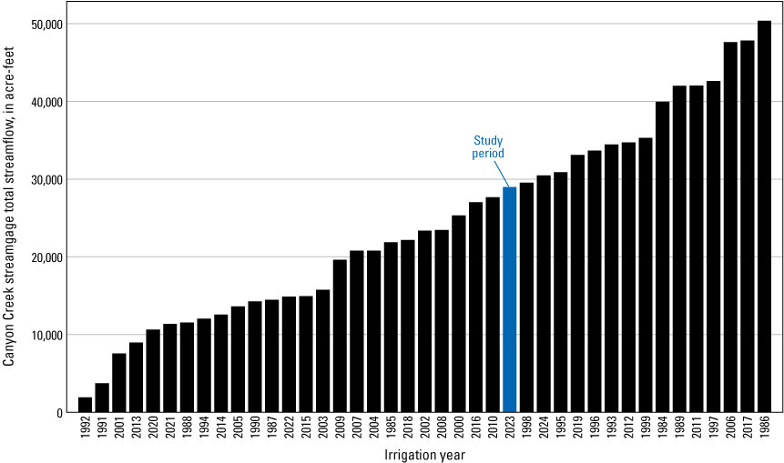
Graph showing total yields for Canyon Creek during irrigation years 1984–2023, Mountain Home area, southern Idaho. Data are from U.S. Geological Survey (2024). Bars are organized from smallest to largest annual yield. An irrigation year is the 12-month period from November 1 through October 31 of the following year and is designated by the calendar year in which it ends.
The estimated imported water volume from Little Camas Reservoir was 10,160 acre-ft. An estimated 2,540 acre-ft was lost during conveyance outside of the study area before reaching Tunnel No. 9. By subtracting this estimated imported water volume from the total flow at the Canyon Creek streamgage, the natural combined streamflow for Syrup and Long Tom Creeks in 2023 was determined to be 18,812 acre-ft.
The Qstreamflow_out values, as reported in table 4, were 6,127 acre-ft for the CGWA, 24,165 acre-ft for the GWMA, and 42,303 acre-ft for the RoSA. For Qswsnakeriver, only the RoSA had a reported volume of 23,158 acre-ft. The calculation of streamflow loss to the Snake River, based on available NWIS measurements, provides an estimate of this outflow component from the RoSA. It is important to acknowledge that without continuous, dedicated gaging stations on all contributing streams, the calculated volumes represent an approximation of the actual flow. Although a more precise and comprehensive understanding would be achieved through full and continuous gaging, these filtered mean discharge estimates offer a first-order approximation of the possible streamflow contributions from the study area, thereby informing our understanding of the regional water budget in the absence of more extensive data and reflecting an attempt to not overestimate contributions of Qmfr to the study area.
Table 4.
Estimated tributary watershed streamflow volumes for irrigation year 2023 for the Mountain Home area, southern Idaho.[An irrigation year is the 12-month period from November 1 through October 31 of the following year and is designated by the calendar year in which it ends. CGWA, Critical Groundwater Area; GWMA, Groundwater Management Area; RoSA, rest of the study area; NA, not applicable]
Precipitation volumes estimated from gridMET (Abatzoglou, 2011, undated).
Qmfr, as defined in equation 7, represents the net surface water contribution from the tributaries that ultimately recharges the lowland aquifers. The Qmfr volumes, which are labeled as “Recharge from tributary watersheds” in table 2, for each subregion are derived from the Qstreamflow_out by accounting for reductions from imported water, diversions (refer to the “Recharge of Applied Water” section), and direct losses to the Snake River. Based on these calculations, the Qmfr was estimated to be 6,127 acre-ft for the CGWA, 14,740 acre-ft for the GWMA, and 7,150 acre-ft for the RoSA.
In addition to Qmfr, estimated Qmbr has been included as an inflow in the overall groundwater budget (eq. 5; tables 2, 5) to provide a more comprehensive representation of total mountain-derived water. However, it is crucial to recognize that the direct contribution of Qmbr to the lowland aquifers of the three primary subregions is highly uncertain owing to the complex subsurface flow paths and inherent assumptions in its calculation. For example, some of this groundwater may be recharged via faults to the deep, confined geothermal aquifer that is largely inaccessible to most users (Nielson and Shervais, 2014).
Table 5.
Tributary water budget of the Mountain Home area, southern Idaho, irrigation year 2023.[An irrigation year is the 12-month period from November 1 through October 31 of the following year and is designated by the calendar year in which it ends. CGWA, Critical Groundwater Area; GWMA, Groundwater Management Area; RoSA, rest of the study area]
Precipitation volumes estimated from gridMET (Abatzoglou, 2011, undated).
Evapotranspiration volumes estimated from OpenET (2024).
The estimated Qmbr values are 6,689 acre-ft for the CGWA, 38,074 acre-ft for the GWMA, and 46,916 acre-ft for the RoSA.
Estimates for mountain aquifer recharge in similar semi-arid mountainous environments (Wilson and Guan, 2004; Taylor and others, 2011; Markovich and others, 2019) exhibit variability influenced by factors such as precipitation, ET, geology, and vegetation cover. For instance, research conducted in the Dry Creek Experimental Research Watershed site in the Treasure Valley near Boise, Idaho, observed that approximately 14 percent of annual precipitation in that watershed is considered mountain block recharge, with the remainder being categorized as mountain front recharge, ET, and streamflow (Aishlin and McNamara, 2011; Kormos and others, 2015; Markovich and others, 2019). These findings align with the observations of Wilson and Guan (2004), who concluded that ET constitutes the largest source of losses from the mountain block across the numerous watersheds compiled in their study.
In this investigation, ET is roughly half of the annual precipitation. Furthermore, estimates of mountain aquifer recharge in other studies, using similar water balance methodologies for tributaries, have been reported to range from 14 to 38 percent of total precipitation (Wilson and Guan, 2004), which is consistent with the estimates in this study. Specifically, the calculated mountain aquifer recharge as a percentage of annual precipitation for each of the tributaries in this study averages 33 percent when using the eeMETRIC ET model (table 5). Recharge within the mountain block itself can happen through fractures, faults, and other permeable pathways within the mountain (Wilson and Guan, 2004; Markovich and others, 2019; Somers and McKenzie, 2020; Montaño-Caro and others, 2024).
Sublimation, where solid water (snow and ice) transitions directly into vapor, was accounted for in the determination of effective precipitation for the Qmbr calculation. In mountainous regions, sublimation can significantly affect the overall water balance, particularly in snow-dominated ecosystems. Under certain conditions, sublimation can account for losses of 10 to 30 percent of total snowpack, influenced by factors such as temperature, wind speed, and relative humidity (Dingman, 2015). Consequently, the effective precipitation available for runoff and infiltration in this study could be lower than simply measured totals. One issue with including sublimation (estimated as 10 percent of total precipitation in the calculation) was that some tributaries resulted in negative Qmbr values. For the purpose of this water budget, these negative Qmbr values were set to zero, because it is currently unknown whether these negative values represent additional losses contributing to Qmfr, or if they are entirely reflected in the ΔStrib value or the overall budget residual.
Furthermore, ΔStrib, as defined in equation 6, is also not explicitly quantified in this budget owing to data limitations. For a one-year budget, ΔStrib is assumed to be less variable and more stable compared to other dynamic components. Therefore, similar to the uncertainties in Qmbr's direct contribution, the unquantified ΔStrib and any unaccounted-for portion of negative Qmbr values are implicitly incorporated into the R from equation 2.
Areal Recharge
Areal recharge, the process by which precipitation infiltrates the soil surface and percolates into the groundwater system, is a crucial component of the water budget, expressed as Qareal_recharge in equations 3 and 5. This analysis covers areal recharge during irrigation year 2023 from two primary sources: (1) non-irrigated lands outside of the tributary watershed (full year); and (2) irrigated lands during the non-irrigation season. Recharge from irrigated lands during the irrigation season is addressed in the “Recharge of Applied Water” section. Surface runoff can also contribute to groundwater recharge through infiltration; for this study, any such infiltrated runoff is assumed to directly contribute to the areal recharge estimate within the study area.
To estimate recharge volumes for irrigation year 2023, this analysis (Thomas, 2026) used a proportional approach, applying historical proportions of deep percolation and runoff (derived from 2008–20 data) to 2023 precipitation data (Allen and others, 2005, 2007; IDWR, 2024h). The approach assumes that the relative proportions of deep percolation and runoff to precipitation remain reasonably consistent over time. This assumption is based on the expectation that, although annual precipitation amounts may vary, the factors controlling the partitioning of precipitation into deep percolation and runoff (for example, land cover, soil properties, and general climate patterns) do not change dramatically from year to year. However, it is acknowledged that the volume, rate, and timing of annual precipitation can significantly affect the derived recharge percentages; therefore, using an average proportion from historical data (which includes a range of precipitation years) may lead to estimates different from those yielded by a median or in particularly anomalous years.
Methods
Deep percolation and surface runoff were estimated using historical data from the ET-IDWR model (Allen and others, 2007; IDWR, 2024a) and 2023 precipitation data (Abatzoglou, 2011, undated). The ET-IDWR model (previously called ET-Idaho), based on the American Society of Civil Engineers standardized Penman-Monteith reference equation, estimates ET, estimated simulated irrigation, deep percolation, and runoff for various land covers and crop types. Historical deep percolation and runoff values from the ET-IDWR model were used to calculate average proportions of these components for different subregions. These proportions were then applied to 2023 precipitation to estimate 2023 recharge volumes. The ET-IDWR model uses daily meteorological data from the Glenns Ferry and Grand View weather stations to compute these variables, assuming sufficient water application to avoid plant stress. Simulated irrigation varies based on meteorological conditions and accounting for both precipitation and ET.
Areal recharge (in acre-feet), in terms of its deep percolation and runoff components, was calculated for each subregion using the following proportional approach:
whereVsS2023
is the estimated deep percolation or runoff volume for s at S in 2023,
PStotal2023
is the total precipitation volume for the entire study area in 2023 (in acre-feet),
ROs
is the historical average proportion of deep percolation or runoff for s, calculated as the average of the annual proportions from 2008–20,
s
is the calculated subregion (CGWA, GWMA, or ROSA), and
S
is the weather station used for calculation (Grand View or Glenns Ferry).
Following the calculations from equation 9, the final estimated deep percolation or runoff volume for each subregion in 2023 (Vs2023) was determined using equation 10, which averages the volumes from the two ET-IDWR stations (Thomas, 2026).
whereVsGV2023
is the estimated deep percolation or runoff volume for s at Grand View station in 2023, and
VsGF2023
is the estimated deep percolation or runoff volume for s at Glenns Ferry station in 2023.
Daily precipitation, ET, deep percolation, and runoff data were obtained from the Grand View and Glenns Ferry ET-IDWR selected weather stations. Because the Glenns Ferry station was offline in 2013-14, daily deep percolation and runoff values from the station were averaged for an 11-year period (2008–20, excluding 2013 and 2014). To match the data available from the Glenns Ferry station, the Grand View station data were averaged during the same time period, excluding 2013 and 2014, as well. Cropland Data Layer (CDL) data (USDA National Agricultural Statistics Service, 2023) provided land cover information. Table 6 links the CDL land cover types to the ET-IDWR crop types used to calculate deep percolation and runoff rates.
Table 6.
The U.S. Department of Agriculture National Agricultural Statistics Service (2023) Cropland Data Layer (CDL) raster value types compared to the Idaho Department of Water Resources (2024a) ET-IDWR crop types used to calculate deep percolation and runoff rates, Mountain Home area, southern Idaho.[All units are presented as they appear in their respective sources]
To estimate the contribution of each land-use type to deep percolation and runoff, the average daily rates from the ET-IDWR model were multiplied by the corresponding areas of each CDL land-use category raster, across three subset regions (fig. 2) for the applicable years of each station (Thomas, 2026). A percentage of total precipitation that becomes deep percolation or runoff was calculated for each region by dividing the volume of deep percolation or runoff for the subregion by the total volume of precipitation recorded at that station. These percentages were then averaged across the applicable years for each subregion in the two station datasets. The ROs was applied to the PStotal2023 estimated from gridMET for each station location for irrigation year 2023. Using these averaged percentages, volumes were calculated for each subregion at each station. Finally, the results from the two stations for 2023 were averaged to estimate the final volumes, which are presented in table 3 as part of the water budget inflows. This analysis includes the acreage of non-irrigated lands for the entire irrigation year and irrigated lands during the non-irrigation season. This method estimates the percentage of precipitation contributing to runoff and deep percolation, offering a simplified yet representative framework for a one-year water budget. The methodologies employed for calculating deep percolation and runoff via ET-IDWR align with previous studies in southern Idaho (Bartolino, 2009; Fisher and others, 2016; Clark, 2022).
Because of the ephemeral and intermittent nature of many surface water features, the actual volume of runoff that exits the basin is uncertain. Although surface runoff can contribute to groundwater recharge, some of it may be lost to ET or may not reach the groundwater system. It was assumed that any runoff from the study area was ultimately recharged as infiltration or stream seepage and that none of it left the study area as streamflow.
Results and Discussion
The Vs2023 of each subregion (eq. 10), when combined, is approximately 5 percent of the annual precipitation volume, resulting in a total of 33,123 acre-ft for the entire study area (table 2). The Vs2023 deep percolation volumes per subregion are 2,874 acre-ft for the CGWA, 18,028 acre-ft for the GWMA, and 8,276 acre-ft for the RoSA; and the Vs2023 runoff volumes per subregion are 385 acre-ft for the CGWA, 1,927 acre-ft for the GWMA, and 1,633 acre-ft for the RoSA
These volumes calculated for irrigation year 2023 are higher than those estimated in previous investigations (Norton and others, 1982; Harrington, 2004), which calculated a volume of precipitation falling on rocky outcrops in their respective study areas (similar to the combined GWMA and CGWA) at 4,400 acre-ft. This study included areal recharge over a much larger and more diverse area, accounting for all land-cover and soil types in the estimation. Additionally, the methodology employed in this study accounts for a broader range of variables, including soil conditions, land types, historical precipitation data, and corresponding ET rates. The deep percolation and runoff values calculated for irrigation year 2023 align closely with the values reported for the CGWA in Tesch (2013), which were in a similar order of magnitude (3,259 acre-ft compared to 2,025 acre-ft).
Recharge of Applied Water
Additional potential sources of inflows to the groundwater system, described herein as applied water sources, include incidental recharge from irrigation, return flows, canal seepage, managed aquifer recharge practices, and a portion of septic system effluent. Each of these sources can contribute to the overall recharge of the aquifer.
Not all applied water recharges the aquifer; some is lost to evaporation or plant consumption (consumptive use). However, the applied water that is not immediately consumed or lost can percolate into the groundwater system and, for this one-year water budget, is considered available for potential recharge. Groundwater recharge is a complex process that can occur over extended periods, and a single-year analysis may not fully capture the long-term dynamics of groundwater storage and release, including recharge during the non-irrigation season. Precipitation falling on irrigated lands during the non-irrigation season is accounted for in Qaerial recharge (eq. 3; refer to the “Areal Recharge” section for more information) and is not included in the applied irrigation calculations.
Applied Irrigation and Delivery Losses
To examine applied irrigation and its associated losses, including delivery losses (which represent recharge to the aquifer), the CIR was estimated using ET values from eeMETRIC, as described in the “Evapotranspiration” section, and gridMET precipitation data.
To accurately estimate the CIR, water sources were categorized into three distinct types based on their documented point of diversion and POUs: groundwater-only, surface-water-only, and mixed-use areas where both sources are used. For mixed-use areas, data from canal companies, water districts, and the IDWR were examined to determine the primary and secondary water sources, when possible. This classification is essential for calculating the relative contribution of each source to the CIR (IDWR, 2024c, d). In cases where sufficient data were unavailable, surface water delivery volumes were prioritized to meet initial CIR demands, with groundwater serving as a supplementary source, or vice versa for metered groundwater and estimating surface water contributions.
By calculating the CIR and subtracting the recorded diversions (surface water and groundwater), it is possible to estimate the losses incurred during irrigation and delivery. Given the nature of the available diversion data, this approach allows for a simplified quantification of both applied irrigation recharges and delivery losses. This methodology has been chosen for the analysis of this one-year water budget to ensure that the results are realistic and applicable for practical purposes, such as the development of future groundwater flow models or regional water management planning.
Methods
To evaluate irrigation losses that contribute to aquifer recharge, losses were estimated using equation 11. This equation incorporates the CIR calculated from eeMETRIC ET values and gridMET precipitation data. The CIR and estimates of applied water from groundwater and surface water were used to quantify irrigation losses to the aquifer as part of the water budget analysis.
whereVlosses
is the estimated volume of water lost during irrigation and conveyance, representing incidental recharge to the aquifer (in acre-feet);
CIR
is the estimated crop irrigation requirement for irrigated lands (in acre-feet), calculated as the ET volume for irrigated lands minus precipitation that has fallen on those lands;
Vapplied_gw
is the total volume of groundwater applied for irrigation (in acre-feet); and
Vapplied_sw
is the total volume of surface water applied for irrigation (in acre-feet).
To evaluate the CIR for the study area, three water-right source categories were established: surface water, groundwater, and mixed use. As detailed in the “Land Use” section, a spatial dataset of irrigated lands for irrigation year 2023 was categorized into these three water-right source categories. Each polygon type was further subdivided into three distinct non-tributary subregions (CGWA, GWMA, and RoSA) and analyzed by irrigation district (fig. 2), enabling a more focused assessment of water use and irrigation practices across the study area and throughout each of the subregions.
The CIR for each irrigated parcel was calculated by extracting monthly precipitation volumes from gridMET datasets and subtracting these from corresponding monthly ET datasets (refer to the “Precipitation” and “Evapotranspiration” sections). Calculations were limited to the irrigation season from April to October 2023. Non-irrigation season ET and precipitation are discussed in the “Areal Recharge” section.
Water delivery data were collected from the Water Management Information System (WMIS; IDWR, 2024g), the IDWR water master reports (IDWR, 2024f, h), and local irrigation districts (Stefanie Kazyaka, MHID, oral and written commun., 2024). These data were used to determine the applied irrigation volumes for each subregion. For areas with reported surface water diversions or groundwater pumpage, these reported volumes were used as the applied irrigation volume. It is important to note that all applied irrigation volumes include conveyance and on-farm application losses (incidental recharge). For areas with reported surface water diversions or groundwater pumpage, these reported volumes were directly used as the respective applied irrigation volume.
For mixed-use areas where reported diversions for one source were not known, the calculated CIR represented the total consumptive use required by the irrigated lands. The estimation process for applied volumes, which accounts for losses caused by inefficiencies, prioritized available data based on water rights. If measured volumes for one source (for example, groundwater) were available, its consumptive use contribution to the CIR was calculated by multiplying the measured applied volume by its assigned efficiency (0.90 for groundwater). The remaining CIR demand was then assumed to be met by the other source (for example, surface water). The corresponding applied volume was determined by dividing the remaining CIR demand by the other source's respective efficiency (0.70 for surface water), thus incorporating its associated delivery and irrigation losses, and vice versa for when surface water was the measured source.
In cases where neither groundwater pumpage nor surface water diversion data were available for mixed-use areas, the total CIR was apportioned to each source based on established water-right priorities or historical distribution patterns. The corresponding applied volumes were then estimated by dividing by their respective efficiencies. Watermaster documents and water rights (IDWR, 2024f) and well information (IDWR, 2024h) assisted with determining estimated volumes of applied water to meet the CIR and respective losses to the aquifer.
Efficiency rates were derived from a literature review and previous studies conducted in southern Idaho (Bartolino, 2009; Clark, 2022). Losses from delivery and irrigation practices were calculated by subtracting the calculated CIR from the total applied irrigation volumes (Vapplied_GW + Vapplied_SW) for each irrigated area categorized by water use type (fig. 2).
Results and Discussion
For the whole study area, a total CIR of 139,627 acre-ft was estimated. Within the CGWA, the CIR was estimated to be 14,029 acre-ft (table 7), and losses (inflows to the aquifer) were determined to be 415 acre-ft. No surface water diversions are reported within the CGWA for these water budget calculations; therefore, all water satisfying the CIR in the CGWA is sourced from groundwater.
Table 7.
Crop irrigation requirements (CIR), surface water and groundwater diversions, and agricultural losses to the regional aquifer during irrigation and delivery for irrigation year 2023, Mountain Home area, southern Idaho.[CGWA, Critical Groundwater Area; GWMA, Groundwater Management Area; RoSA, rest of the study area]
Evapotranspiration rates estimated from rasters obtained from OpenET (2024).
Within the GWMA subregion, the estimated CIR was 73,252 acre-ft (table 7). This area uses a mix of groundwater and surface water for irrigation, primarily sourced from Canyon Creek. The Mountain Home Reservoir distributes water along two major canals to users in the MHID (fig.1). For irrigation year 2023, which saw above-average precipitation, the MHID was able to triple its share allocations of water to its users, resulting in over 17,000 acre-ft sourced from Water District 61 and Rattlesnake Creek (Stefanie Kazyaka, MHID, oral and written commun., 2024). In years with lower allocations, the shortfall is made up by increased groundwater pumping for those with mixed water rights. The GWMA had estimated incidental losses of 15,580 acre-ft.
The final subregion, RoSA, primarily sources water from the Snake River and has an estimated CIR of 52,346 acre-ft (table 7). This subregion experienced significant irrigation and delivery losses owing to the larger amount of surface water available, compared to the GWMA and CGWA. Losses were estimated to be 63,124 acre-ft. These figures do not account for water returned to the Snake River during irrigation; if known, net losses would be lower. Additionally, some irrigation entities in the RoSA have canals with known areas of high loss (Cory Carnahan, Snake River Irrigation District, oral commun., 2024), and the amount of water returned as runoff from flood irrigation or canals remains uncertain.
Consumptive use, defined as the amount of water extracted from a source that is not returned, is a critical factor in water resource management (IDWR, 2022). In this study, consumptive use was estimated by dividing the CIR by the irrigated acreage for each subregion (CGWA, GWMA, and RoSA; table 7). The calculated consumptive use rate for irrigation year 2023 was from 2.05 to 2.25 acre-feet per acre, depending on the specific subregion. These values are lower than the IDWR-reported consumptive use for the study area of 3.0 acre-feet per year per acre (acre-ft/yr/acre; rounded to the nearest 0.5 acre-ft/yr/acre; IDWR, 2022). However, it is important to note that 2023 was an above-average water year, characterized by significant precipitation and snowpack, potentially contributing to a lower overall consumptive use. Several factors could contribute to the lower consumptive use estimates compared to those reported by IDWR. Improved irrigation efficiency through more advanced technology could lead to less water being extracted for consumptive use, as more water is effectively applied for crop growth rather than being lost to evaporation or runoff. A potential shift in crops being grown could also contribute. Along with a lower calculated consumptive use, this investigation calculated lower irrigated acres than previous studies in the area, at 39,560 irrigated acres for the combined CGWA and GWMA, which is fewer than the 41,911 acres calculated by Norton and others (1982) for the same area.
The analysis of irrigation and delivery losses in the study area reveals that higher recharge levels, associated with above-average precipitation, correlate with increased surface water irrigation losses. These losses are unevenly distributed; areas supplied by the Snake River, including the Snake River Irrigation District, King Hill Irrigation District (collectively within the RoSA), experienced significantly greater losses compared to areas such as the GWMA, where groundwater is used as a supplemental source. The GWMA's Canyon Creek yield, which ranked 15th in a 40-year streamgage record (fig. 5), suggests that higher losses during wet years are not regular occurrences in areas primarily relying on groundwater. In contrast, the RoSA benefits from a reliable water source from the Snake River, regardless of wet or dry conditions, likely leading to consistently higher irrigation volumes and associated recharge of the aquifer from losses. The CGWA, which relies entirely on groundwater, demonstrates higher efficiency in irrigation practices, resulting in less incidental recharge overall. This pattern suggests that surface water irrigation systems, such as those prevalent in the RoSA, generally exhibit lower efficiency compared to groundwater-dependent systems, like the CGWA. This observation is supported by efficiencies calculated from available recorded information; for example, surface water diversions in areas such as the Snake River showed a wide range of efficiencies, including very inefficient cases owing to unknown return flows, or around 70 percent. In contrast, groundwater efficiencies were consistently higher, aligning with the assigned 0.90 efficiency used in this report. In general, years with higher precipitation and streamflow tend to result in greater surface water deliveries, which can lead to increased conveyance losses and enhanced groundwater recharge owing to the movement of larger volumes of water compared to drier years.
Using remote sensing and ground-based diversion data, this study estimates consumptive water use and identifies losses during irrigation and delivery. These findings highlight the need to understand the relationship between water application methods and operational inefficiencies, particularly in water-scarce regions. To improve water budget assessments, it is essential to refine delivery loss estimates through detailed analyses of canal systems and irrigation practices. Specifically, calculations of losses (and therefore recharge) relied on estimates of surface water and groundwater delivery and assumptions about efficiency in each system where direct measurements were not available. Therefore, improved measurements of delivery and efficiency, including direct measurements of canal losses and irrigation application rates, would significantly enhance the accuracy of water use calculations.
Managed Aquifer Recharge
Both state and private entities are actively involved in managed aquifer recharge projects, aiming to replenish groundwater levels with excess water, QMAR in equations 3 and 5. In recent years, the MHID has implemented a strategy to address declining groundwater levels by intentionally diverting excess water into gravel pits (Owsley, 2017). Managed aquifer recharge captures excess water and uses basins and injection wells to infiltrate the water. Similar managed aquifer recharge initiatives are being undertaken in other regions of southern Idaho, particularly within the Eastern Snake Plain Aquifer (Hipke and others, 2022).
A study conducted in 2017 by the IDWR and a private consulting firm (Owsley, 2017) assessed water losses during conveyance from the diversion structure to the Feeder Canal along Canyon Creek and into the gravel pits north of Interstate 84 (labeled “Managed aquifer recharge basin” in fig. 1). During the period from early February to late April, approximately 4,460 acre-ft of water was estimated to be lost during conveyance or recharged in the gravel pits. The study also observed an increase in water levels of approximately 22 ft in nearby monitoring wells, correlating with the duration and volume of water diverted (Owsley, 2017). Measurements taken downstream of Interstate 84 during this timeframe recorded flows as high as 105 cubic feet per second (ft3/s), which flowed towards and potentially into the Snake River (Owsley, 2017). It is important to note that there was above-average precipitation and snowpack in 2017, conditions that exceeded those observed in irrigation year 2023 (fig. 4). This difference is also reflected in Canyon Creek volumes recorded between the two years (fig. 6).
Methods
No direct measurements of managed aquifer recharge were publicly available. The estimated volume of managed aquifer recharge for irrigation year 2023 was provided by Terry Scanlan (HDR, Inc., written commun., 2024), based on operational data from SPF Water Engineering, LLC.
Results and Discussion
For irrigation year 2023, the reported volume of managed aquifer recharge within the study area was 910 acre-ft (Terry Scanlan, HDR, Inc., written commun., 2024), which was subtracted from the mountain front recharge volumes to avoid double-counting. All of this volume was diverted from Canyon Creek prior to the irrigation season. For the purpose of this water budget, it was assumed that the full volume contributed to the total inflows for the GWMA. Notably, no additional managed aquifer recharge was reported for 2023 in the CGWA or the RoSA.
The effectiveness of managed aquifer recharge in the region is strongly influenced by the availability of excess streamflow during the pre-irrigation season, which in turn depends on precipitation totals from the non-irrigation season. This reliance on excess streamflow, coupled with the observed difference in reported managed aquifer recharge volumes between 2023 (910 acre-ft in the GWMA) and the findings of the 2017 study (4,460 acre-ft), suggests that the amount of managed aquifer recharge is likely to vary substantially interannually.
Effluent Returns
Outside of major population centers in the study area, including the City of Mountain Home, Glenns Ferry, the MHAFB, the IDARNG, and Hammett, the majority of the rural population is served by self-supplied domestic wells and accompanying septic systems (Horrocks Engineers, 2019; USGS, 2024). In the GWMA, the reuse of effluent water for irrigation is a common practice in larger population centers, such as the City of Mountain Home, which stores water in lined catchment basins and applies it for local crop irrigation (Horrocks Engineers, 2019; Idaho Department of Environmental Quality, 2024).
Domestic Effluent
Domestic effluent return represents the portion of self-supplied domestic water that, after use, infiltrates back into the aquifer and contributes to groundwater recharge, QDom in equations 3 and 5. This section outlines the methods employed to quantify domestic pumpage and subsequently estimate these return flows across the study area.
Effluent return represents a percentage of the total domestic water pumped. To estimate domestic pumpage, the number of domestic wells was multiplied by the average household water withdrawal, which was derived from census data on household size and per capita water consumption. The estimate of effluent return from domestic self-supplied wells is determined based on 2023 Elmore County census data, assuming an average household size of 2.59 persons (U.S. Census Bureau, 2023). Water withdrawal estimates from the USGS water use datasets were obtained through NWIS, yielding an average per capita withdrawal rate of 162 gallons per person per day (USGS, 2024). This approach estimates total domestic water withdrawn (pumped) to calculate inflows in this section and outflows in the following “Outflows” section. To determine the number of domestic wells in the study area and the three subset areas, the IDWR wells database (IDWR, 2024i) was queried for all wells labeled as “domestic,” resulting in 947 wells, of which 159 were in the CGWA, 657 were in the GWMA, and 131 were in the RoSA (table 8). It is important to note that the final number of domestic wells is likely underestimated owing to the presence of wells in the database without a well-use designation.
Table 8.
Water use and effluent returns for self-supplied domestic wells for irrigation year 2023 in the Mountain Home area, southern Idaho.[CGWA, Critical Groundwater Area; GWMA, Groundwater Management Area; RoSA, rest of the study area]
Use rate was compiled from U.S. Geological Survey Water Use data for Elmore County (U.S. Geological Survey, 2024).
Data compiled from U.S. Census Bureau bulletin for Elmore County (U.S. Census Bureau, 2023).
To calculate potential returns to the aquifer from domestic effluent, the total domestic water use per household (in gallons per day) was first determined by multiplying the per-person use rate by the average household size and then by the number of wells in each area. This volume was subsequently converted to acre-feet. An adjusted return rate of 80 percent was chosen to account for assumed increases in water use during warmer months for lawn irrigation. This adjustment was made because the study area is at a lower elevation than the Wood River Valley and Big Lost River Valley aquifers (Bartolino, 2009; Clark, 2022), where return rates of 95 percent were observed. The lower elevation and the fact that the random forest irrigated model does not typically identify ET from small domestic parcels (for example, lawns) owing to raster pixel size, suggest higher consumptive use owing to lawn irrigation, justifying the lower return rate.
The total estimated infiltration volume for the entire study area was 356 acre-ft. The GWMA accounted for the majority of this return volume, with 247 acre-ft, followed by 49 acre-ft in the RoSA and 60 acre-ft in the CGWA (table 8). The larger amount of effluent return in the GWMA is attributed to it having the largest population and the most domestic wells.
Municipal Effluent
Municipal effluent, QMuni in equations 3 and 5, refers to the treated wastewater generated primarily from residential, commercial, and industrial sources and treated in centralized wastewater treatment plants before reuse or discharge. This study calculated returns to the aquifer for the City of Mountain Home, the MHAFB, and the IDARNG. Treated effluent is typically used for various purposes, including agricultural irrigation, landscape maintenance, and industrial processes. The treatment process involves several stages, including physical, biological, and chemical treatments, to remove contaminants and ensure that the water meets safety standards before being reused or discharged (Idaho Department of Environmental Quality, 2024).
The largest population center in the study area, the City of Mountain Home, uses eight shallow-lined lagoons, covering a total of 206 acres, to store and treat wastewater from the city’s treatment plant. This effluent is used in the summer months to irrigate as much as 747 acres of croplands adjacent to the wastewater treatment plant (Horrocks Engineers, 2019).
Similarly, the MHAFB reuses wastewater at an onsite treatment plant, redistributing treated water for irrigation on its golf course and green spaces (U.S. Air Force, 2024). Any excess treated water is directed to six designated rapid infiltration basins, which are counted as inflows to the GWMA. In contrast, the IDARNG manages its wastewater through infiltration lagoons, which contribute to the overall effluent return calculated for the water budget.
Municipal effluent was primarily calculated using annual reuse reports submitted to the Idaho Department of Environmental Quality (U.S. Environmental Protection Agency, 2011; Mountain Waterworks, Inc., 2019; City of Mountain Home, 2024; U.S. Air Force, 2024). This approach was applied to both the City of Mountain Home and the MHAFB. In instances where these reports were unavailable, such as for the IDARNG, engineering as-builts for wastewater treatment plants were used to estimate potential infiltration volumes for irrigation year 2023. This estimation involved using metered wells as inputs for water use and calculating inflows to the treatment plants, following similar methods outlined in the “Domestic Effluent” section, with an assumed 80-percent return rate.
The City of Glenns Ferry is an exception to these methods; its treated effluent is discharged into rapid infiltration basins located just off the banks of the Snake River. Because of proximity, this water is assumed to have negligible aquifer residence time (U.S. Environmental Protection Agency, 2011) and, therefore, is not included as an inflow to the RoSA area aquifer. Additionally, the City of Hammett does not have a centralized wastewater treatment plant, and its effluent return is accounted for in the domestic effluent return for that area.
The 2020 comprehensive management plan for the City of Mountain Home (Horrocks Engineers, 2019) reports an average flow rate to the treatment plant of 1.3 Mgal/d or 1,456 acre-feet per year (acre-ft/yr), which is higher than the reported 2023 use volume of 983 acre-ft (City of Mountain Home, 2024). CIR estimates for the agricultural area served by the wastewater treatment plant (351 acres in 2023) were used to reduce the overall applied irrigation CIR within the GWMA, as calculated in the “Applied Irrigation and Delivery Losses” section. The CIR for these irrigated parcels served by the wastewater treatment plant was 904 acre-ft during the irrigation season. The loss to groundwater was calculated as the difference between the applied water (577 acre-ft of treated effluent and 406 acre-ft of additionally pumped groundwater for the irrigated lands) and the calculated CIR, resulting in 77 acre-ft. It is important to note that these estimates do not account for potential evaporative losses from the eight treatment lagoons or gains from incidental rainfall on the lagoons.
The MHAFB wastewater treatment plant processes wastewater, primarily reusing it for the irrigation of its golf course and various irrigation zones on the base. The majority of treated wastewater is used to irrigate the base’s golf course and numerous greenways and is considered consumed. A total of approximately 20 acre-ft was recharged at their rapid infiltration basins and is considered effluent return and inflow to the aquifer in the overall budget, with the remainder (534 acre-ft) going to irrigation, which was reported in their 2023 wastewater reuse permit annual report (U.S. Air Force, 2024).
The remaining area, the IDARNG, consists of two lagoons and subsurface large soil absorption systems. Metered wells that contribute to the wastewater treatment plant were sourced from the IDWR at 22.7 acre-ft. An estimated 80-percent efficiency was used to calculate inflows to the treatment plant at 18.16 acre-ft. A total of 11 acre-ft was estimated to be recharged during the 2023 irrigation season. A daily evaporation rate of 5,100 gallons per day (7.3 acre-ft/yr), which was calculated in the as-builts for the system, was taken into account when estimating the annual effluent return and subtracted from the estimated inflows to the treatment plant (Mountain Waterworks, Inc., 2019).
Municipal effluent return for the study area totaled 131 acre-ft, all of which was in the GWMA. Reuse of groundwater-sourced water is the primary reason for a low amount of effluent return, based on the amounts pumped by each of the areas, and is less than one percent of the overall inflows calculated for the water budget for the study area.
Outflows
The following section focuses on the outflows of the groundwater budget components, Qoutlow in equations 1 and 2. In addition to details on outflow components, each subsection focuses on how Qoutlow, in practice, becomes Qoutlow_estimated in equation 4.
Groundwater Discharge to Snake River
Groundwater discharge to the Snake River, expressed as QSnakeRivgw in equations 4 and 5, represents a potentially significant outflow from the regional aquifer system. Directly quantifying the portion of this discharge originating specifically from the study area, however, is challenging owing to the area’s complex hydrogeology and contributions from adjacent watersheds. Previous studies estimated groundwater discharge to the Snake River for a section bounded by the streamgages at Snake River at King Hill, Idaho (USGS 13154500), and at Snake River Near Murphy, Idaho (USGS 13172500). For the section of the Snake River that falls within the current study area, Wood and others (2014) estimated a groundwater discharge of approximately 415 ft3/s, and Newton (1991) reported a cumulative groundwater discharge of 465 ft3/s to the Snake River based on groundwater flow model boundary conditions.
It is important to note that these regional estimates cannot be definitively attributed solely to groundwater originating from within the study area's boundaries, because flows from areas to the south and north also contribute to Snake River discharge in this reach. Therefore, given the inability to discern the specific contribution from the study area, QSnakeRivgw is considered an unquantified outflow in this water budget and is incorporated into the overall residual.
Groundwater Pumpage
Groundwater use in the study area is monitored by the IDWR through the implementation of metered wells within Groundwater District 161. On September 23, 2016, a Preliminary Order requiring the installation of measuring devices for groundwater rights and diversions in the Mountain Home area was issued by IDWR. This order mandates that flow meters be installed on groundwater irrigation pumps with exemptions for domestic and stockwater uses, diversions for irrigation of 5 acres or less, and non-irrigation uses with a diversion rate of less than or equal to 0.24 ft3/s (IDWR, 2016).
The metering initiative aims to enhance water management practices and address concerns regarding groundwater depletion. A watermaster is responsible for the routine collection of recorded volumes for metered wells. If a well’s meter is broken or has not been installed yet, pump volumes are estimated based on headgate and consumptive use rates calculated regionally for Idaho by IDWR. These rates are used for estimating the pumping required for crop irrigation along with water-right adjudication, licenses, permits, and transfers. Consumptive use rate is the requirement of the most water-consumptive crop and is rounded to the highest 0.5 acre-ft/yr/acre. Similarly, the headgate requirement is the amount of water required to irrigate with irrigation application efficiency applied (IDWR, 2022; Brian Ragan, IDWR, oral commun., 2023). Three groundwater pumpage categories (agricultural, domestic, and municipal) are discussed in the following sections.
Agricultural
This section discusses groundwater pumpage associated with irrigation water pumped for agricultural crops, which is expressed as QAgpump in equations 4 and 5.
Methods
Metered well data were gathered from the WMIS (IDWR, 2024g) and assessed based on associated water rights and in relation to irrigated acres (table 7). The IDWR provides annual values through the WMIS, which include both metered and estimated data. Some of these estimated values are based on water-right information and crop consumptive use estimates for the study area. In this assessment, certain annual estimates, particularly those based on the calculated CIR, were identified as outliers and subsequently adjusted. A total of 352 wells and their metered volumes were assessed for irrigation year 2023 (Thomas, 2026). Not all metered wells were active or had usable meter data; in some cases, reported volumes were estimated because of missing or incomplete measurements (fig. 7; IDWR, 2022, 2024g).
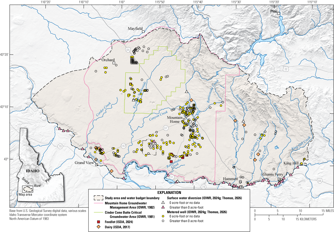
Map showing metered wells and surface water diversions from the Idaho Department of Water Resources (IDWR) Water Management Information System and dairy and feedlot locations from the Idaho State Department of Agriculture (ISDA), Mountain Home area, southern Idaho, for irrigation year 2023. An irrigation year is the 12-month period from November 1 through October 31 of the following year and is designated by the calendar year in which it ends.
Wells with estimated pumpage values and outliers were altered based on feedback from Brian Ragan (IDWR, oral commun., 2023). Values that were assessed to be too high based on a well’s location and served irrigated acres were modified by the USGS using CIR estimates with a 90-percent efficiency (CIR × 1.1). This approach was applied where initial pumpage estimates were deemed unreliable, and the primary water source for the irrigated acreage was corrected based on its crop water demand. For a comprehensive discussion of how multiple water sources and irrigation practices were integrated with the CIR to determine applied water across the study area, refer to the “Recharge of Applied Water” section.
Results and Discussion
Of the 352 WMIS wells in the study area, 164 had reported values greater than zero. Of these wells, 129 had full-year volumes, and 35 had full-year IDWR estimated volumes. The total groundwater pumpage volumes were 14,229 acre-ft for the CGWA, 26,018 acre-ft for the GWMA, and 1,880 acre-ft for the RoSA (table 7).
Some reported well pumpage values fell outside the expected range based on comparison with estimated CIR or were annual estimates (IDWR, 2024h). Notably, several WMIS wells, particularly within the CGWA, exhibited significant discrepancies compared to expected pumping rates for their associated irrigated acreage, often informed by CIR estimates. These discrepancies were attributed to incorrect unit conversion factors. In certain instances, reported values exceeded expected ranges by more than an order of magnitude; for example, values initially reported as approximately 11,000 acre-ft were corrected to approximately 700 acre-ft after applying the appropriate unit conversion factor. These unit conversion factors come from IDWR field inspections of the metering units at each wellhead. These corrected values, along with unmodified values from WMIS, were applied in final water budget calculations (Thomas, 2026). If uncorrected, these discrepancies would have significantly inflated groundwater pumpage estimates, particularly in the CGWA and other areas.
Domestic
Domestic pumpage, QDompump in equations 4 and 5, is water withdrawn from a well for use by a single household or a small subdivision of homes. Extracted water is predominately used for drinking water and washing, along with lawn and garden irrigation.
Methods
Domestic pumpage accounts for a small percentage of the total groundwater pumped in the study area and an even smaller percentage of the overall groundwater budget. Details on how domestic supply was calculated are presented in the “Domestic Effluent” section. The calculation of overall domestic supply used the same methods: the average number of people per household (U.S. Census Bureau, 2023) was multiplied by the average per capita water use of self-supplied households (USGS, 2024), and then the result was multiplied by the number of domestic wells in each subregion within the study area (table 8).
Results and Discussion
The pumpage volume for the CGWA was 75 acre-ft; for the GWMA, 309 acre-ft; and for the RoSA, 62 acre-ft. For the entire study area, the total pumpage volume was 446 acre-ft (table 8). Domestic pumpage accounts for less than 1 percent of the total outflow in the groundwater budget (table 2). Because domestic pumpage is such a small component of the overall volume, any uncertainty associated with these domestic pumpage totals is also expected to be minimal, thereby having a negligible effect on the overall groundwater budget.
Municipal
In this section, “municipal” refers to groundwater pumped, QMunipump in equations 4 and 5, by public water systems to supply drinking water to communities within the study area. While municipal supply can include both groundwater and surface water, this analysis focuses specifically on the groundwater component.
Methods
The City of Mountain Home, King Hill, the MHAFB, and the IDARNG primarily rely on groundwater wells as their sources of drinking water. In contrast, the City of Glenns Ferry uses both a well and surface water from the Snake River for its municipal water supply, and Hammett predominantly depends on self-supplied domestic wells. Total estimated groundwater pumpage volumes for this study are based on data collected from the WMIS (IDWR, 2024g).
Results and Discussion
Overall, the total reported volume pumped by municipalities in the study area is estimated to be 6,216 acre-ft (table 2). Because there are no municipal groundwater withdrawals in the CGWA, only the GWMA and the RoSA had reportable values of 6,126 acre-ft and 90 acre-ft, respectively. In total, municipal pumpage represents 12.5 percent of the overall total water budget outflows.
Livestock Operations
This section quantifies the consumptive water use associated with livestock operations, QLivestockpum, primarily dairy and feedlot activities, within the study area and its non-tributary subregions (fig. 7). Consumptive use represents water removed from the local water budget through processes such as water consumed by livestock (for example, drinking and milk production) and evaporation and is therefore considered an outflow. Data from IDWR Memo #36 (Sterling, 1992) provided guidance on estimating diversion rates and volumes for dairy water-right claims. Additionally, data from the Idaho State Department of Agriculture (ISDA; ISDA, 2017, 2024) and the USDA National Agricultural Statistics Service (2023) were used to identify dairy and feedlot locations and estimate animal units.
Methods
The assessment of consumptive water-use for dairy operations focused on two primary components: milk production and evaporation from wastewater lagoons. Estimates of consumptive water-use for milk production were based on the number of dairy cows and their production rates, with consumptive water-use for dairy cattle estimated to be 0.0058 acre-feet per year per cow from wastewater lagoons (Sterling, 1992). Data from the USDA National Agricultural Statistics Service and the ISDA were used to determine the number of dairies and feedlots within the study area, along with estimates of animal units for each operation. The ISDA animal unit count, or operational capacity, was cross-referenced with the USDA National Agricultural Statistics Service bulletin on animal units for 2023 in Elmore County (USDA National Agricultural Statistics Service, 2023).
Dairy and feedlot operations commonly use wastewater lagoons for waste management, and evaporation from these lagoons can represent a significant portion of total water consumption. Factors such as lagoon size, depth, and climatic conditions influence evaporation rates. Aerobic lagoons, which are shallower and possess larger surface areas, are more susceptible to evaporation compared to anaerobic lagoons, which have smaller surface areas and crust formations that minimize evaporation (Sterling, 1992).
From aerial imagery investigations (Planet Labs, Inc., 2023), the area of each lagoon pool was determined. For lagoons larger than half an acre, evaporation can be approximated using annual ET-IDWR reference ET, specifically alfalfa rates, and multiplied by the area of the lagoon to estimate consumptive evaporation loss (Sterling, 1992). It is important to note that, although manure stacks are also a prevalent waste disposal method in this area, the evaporation from these stacks is minimal and considered negligible for the purposes of this report.
Table 9.
Consumptive use for livestock operations for irrigation year 2023 in the Mountain Home area, southern Idaho.[An irrigation year is the 12-month period from November 1 through October 31 of the following year and is designated by the calendar year in which it ends. AU, animal unit; CGWA, Critical Groundwater Area; GWMA, Groundwater Management Area; RoSA, rest of the study area]
Data for consumptive use rates for livestock operations from Sterling (1992).
Area of treatment lagoons calculated from aerial imagery (Planet Labs, Inc., 2023).
Data for evaporative loss rates from Glenns Ferry reference evapotranspiration alfalfa crop (Idaho Department of Water Resources, 2024a).
Methods for calculating evaporative loss rate from treatment lagoons from Sterling (1992).
Results and Discussion
The total estimated consumptive use (table 9) of livestock operations within the study area for irrigation year 2023 was 879 acre-ft, distributed across the CGWA, GWMA, and RoSA with estimated volumes of 76 acre-ft, 621 acre-ft, and 182 acre-ft, respectively (table 2).
Although well data from WMIS were available for some dairy operations, these data were not directly incorporated into the analysis owing to the potential for water to be used for both livestock and irrigation purposes. To address the ambiguity of these recorded volumes, a conservative approach was used to estimate consumptive use based on livestock numbers, water use rates, and methodology developed by the IDWR (Sterling, 1992).
Groundwater Budget Residuals
In an ideal conceptualization, the difference between total inflows (recharge) and total outflows (discharge) within a defined area and time period represents storage change in the groundwater system (eq. 1). In practice, subtracting total outflows from total inflows equals the residual (eq. 2). The residual is equal to the change in storage, plus the sum of all errors associated with the measurements and calculations, and any unquantified inflows or outflows from the system, such as lateral groundwater flows across study area or subregion boundaries and groundwater discharge to the Snake River (eq. 5). These residuals provide a valuable metric for assessing the overall balance of a groundwater system, reflecting both actual storage change and unaccounted components.
The calculated groundwater budget residuals for irrigation year 2023 (fig. 3; table 2) revealed distinct differences among the studied groundwater management areas. The CGWA exhibited a residual of 2,170 acre-ft (table 2). This positive value contrasts with observed long-term declines in groundwater levels and historical trends (Tesch, 2013; SPF Water Engineering, LLC, 2017), suggesting that factors influencing the residual (such as unquantified outflows or overestimated inflows) may be significant in this area.
In contrast, the GWMA and the RoSA exhibited positive residuals of 56,563 acre-ft and 124,933 acre-ft, respectively (table 2). Although these positive values suggest a net gain of groundwater in these areas, it is important to recognize that they also represent a lumped quantity encompassing significant unquantified components and potential errors. Major inflows, such as recharge from applied surface water for irrigation, mountain front and mountain block recharge, conveyance losses, and areal recharge, influence the positive residuals. However, these figures are also affected by substantial unquantified outflows, including groundwater discharge across subregion boundaries and groundwater flow to the Snake River. Similarly, the large positive residual in the RoSA is primarily driven by high volumes of applied irrigation and delivery losses during the irrigation season and an unknown amount of irrigated water that returns to the Snake River. It is also important to note that the relatively minor amount of pumping in the RoSA does little to offset the large amount of incidental recharge in this subregion.
The one-year timeframe of this budget also introduces biases to the calculated residuals. First, irrigation year 2023 was a wetter than average year for precipitation, which can skew the overall water budget and its resulting residual, compared to long-term averages. Second, several budget components experience significant lag times between infiltration and eventual recharge, meaning a one-year budget may not accurately reflect long-term average recharge rates. This is particularly relevant for mountain front and mountain block recharge, where infiltration into the mountain block does not immediately translate to recharge into the underlying study area aquifers, potentially muting short-term precipitation signals. Similarly, areal recharge from precipitation and applied water can experience lags in areas with deep vadose zones. These temporal disconnects introduce uncertainty into the single year's residual, because they may not fully capture the influence of longer-term recharge and discharge processes.
Nonetheless, this investigation offers valuable insights into contemporary budget components and identifies key data gaps, aiming to inform future data collection strategies that will enhance the accuracy of water budget assessments in this region.
Changes in Groundwater Storage
A detailed analysis of groundwater level fluctuations between spring and autumn 2023, presented by Zinsser and Ducar (2025), examined groundwater level fluctuations in the Mountain Home area, considering the hydrogeologic conditions of the study area. Their analysis characterized the spatial distribution of groundwater level changes, providing context for the water budget analysis and revealing a complex pattern across different regions. However, it should also be noted that these changes only bracket the irrigation season and do not reflect a full year's worth of storage change, and this mismatch in timing is representative of a temporal uncertainty.
In the CGWA, groundwater levels declined between spring and autumn 2023. Storage change calculations for this area ranged from −3,620 to −23,250 acre-ft (Zinsser and Ducar, 2025, table 6), and the storage of some wells dropped more than 20 ft. This trend is consistent with long-term historical data, indicating a persistent imbalance between groundwater withdrawals and recharge in the CGWA. However, it contrasts with the calculated groundwater budget residual for the CGWA, which showed a net increase of 2,170 acre-ft for irrigation year 2023 (table 2). This discrepancy suggests that, although observed declines indicate overall long-term storage depletion, the water budget's positive residual for this specific year may reflect unquantified outflows or other complexities not fully captured by the budget components. For context, the metered groundwater extraction summarized from WMIS (14,229 acre-ft; table 2) for the 2023 irrigation season falls within the calculated storage change range (average of −13,620 acre-ft; Zinsser and Ducar, 2025). Both Zinsser and Ducar's (2025) hydrogeologic storage change estimates and the WMIS withdrawals primarily reflect irrigation season extraction.
Similarly, for the combined groundwater management areas (GWMA and CGWA), storage change was calculated to range from −8,860 to −64,930 acre-ft (Zinsser and Ducar, 2025, table 6), which is within reasonable agreement when compared to the total estimated and metered groundwater pumpage for the area from WMIS of approximately 40,000 acre-ft. However, this regional storage decline contrasts with the positive residual of 56,563 acre-ft calculated for the GWMA in the current water budget (table 2), further highlighting the complexities and uncertainties inherent in balancing a groundwater budget.
In contrast, areas near the Snake River and irrigated lands in the southern part of the GWMA, along with the northern part of the perched groundwater zone near Mountain Home, experienced increasing or stable groundwater levels attributed to surface water irrigation (Zinsser and Ducar, 2025). In this northern area, surface water availability for irrigation is more directly dependent on annual precipitation volume and is supplemented by groundwater pumping, making it more susceptible to inter-annual variations. Calculated storage changes for irrigation year 2023, a year with near-normal to above-normal precipitation (table 3), were 1,230 to 10,670 acre-ft for the RoSA and 1,410 to 11,690 acre-ft for the perched groundwater zone (Zinsser and Ducar, 2025, table 6). These storage increases correspond with areas receiving greater applied recharge from surface water irrigation (fig. 2). This greater recharge is attributed to both increased surface water delivery volumes during the wetter year and the associated irrigation losses during conveyance and application. Although these losses represent inefficiencies in the irrigation system, they contribute to incidental recharge of the aquifer. The larger positive residual in the RoSA suggests greater recharge in this area, consistent with the observed storage increase (Zinsser and Ducar, 2025) and calculated losses of surface water during conveyance and applied irrigation. However, it is important to note that, although the perched groundwater zone has shown positive storage changes (Zinsser and Ducar, 2025), the water budget presented in this report does not distinguish between this zone and the regional GWMA, which Zinsser and Ducar (2025) reported as experiencing negative storage changes. This spatial aggregation in the budget may obscure localized storage trends. This water budget study examines the likelihood that in drier years, characterized by reduced snowpack and diminished imported surface water from out-of-basin storage, irrigators with mixed-use rights would likely increase their reliance on groundwater pumping. This shift would result in greater groundwater extraction coupled with reduced incidental recharge, thereby potentially leading to groundwater declines and negative storage changes in the GWMA.
Uncertainty and Errors in the Groundwater Budget
Constructing a groundwater budget, whether for a single year or multiple years, presents several limitations and challenges. These challenges arise from uncertainties associated with limitations in measurement methodologies, the underlying spatial and temporal variability of hydrogeological systems, and the timing of observations and response delays. For example, the timing of precipitation events relative to streamflow measurements can introduce uncertainty, as can the lag time between recharge events and their effect on groundwater levels. These factors contribute to uncertainty in both short-term and long-term budget assessments.
Estimation Uncertainty
Many crucial budget components, such as areal recharge, tributary streamflow, surface water loss to the Snake River, surface water seepage, and sublimation, lack direct measurement and require estimation based on available data. For instance, areal recharge is often estimated using empirical relationships derived from precipitation and soil properties. While these relationships provide valuable insights, they inherently involve some degree of uncertainty. Similarly, tributary streamflow is often estimated using limited gaging data or through rainfall-runoff models. These estimation methods, while necessary, reflect the limitations of available data and can influence the accuracy of calculated water budget components and overall residuals.
Input Data Uncertainty
Even direct measurements, such as those related to irrigation losses or groundwater pumpage, are subject to measurement errors and estimations, particularly when measurement devices fail to record or when estimates are based on historic rates with a variability in crop type or irrigation methodology. Moreover, input parameters like precipitation and ET contribute to overall budget uncertainty. Precipitation data can be spatially variable, and point measurements may not accurately represent regional precipitation patterns. ET estimates, derived from remotely sensed data and meteorological observations, are subject to uncertainties related to atmospheric conditions, land surface characteristics, and the respective model parameterizations.
Temporal Mismatch Uncertainty
The relatively short timeframe of a one-year budget can further increase the effect of these uncertainties. Hydrological processes operate over multiple timescales. A single year inherently cannot capture the full range of natural variability in precipitation, streamflow, and recharge. First, irrigation year 2023 was not an average year for precipitation, which can skew the overall water budget and its resulting residual compared to long-term averages. Second, several budget components experience significant lag times between infiltration and eventual recharge, meaning a one-year budget may not accurately reflect long-term average recharge rates. This is particularly relevant for mountain front and mountain block recharge, where infiltration into the mountain block does not immediately translate to recharge into the underlying study area aquifers, potentially muting short-term precipitation signals. Similarly, areal recharge from precipitation and applied water can experience lags in areas with deep vadose zones. Multi-year datasets are needed to understand long-term trends and the influence of climatic cycles on groundwater systems.
Consequently, although groundwater budgets provide valuable insights for water resource management, the inherent limitations of available data and the dynamic nature of groundwater systems necessitate careful consideration of uncertainty when interpreting budget results, particularly for short-term assessments. Among the various components, tributary recharge, areal recharge, mountain front and mountain block recharge, streamflow losses to the Snake River, and groundwater discharge to the Snake River are likely to be the most significant sources of uncertainty in this water budget.
Suggestions for Future Data Collection
As discussed in the “Uncertainty and Errors in the Groundwater Budget” section, constructing groundwater budgets, whether for a single year or multiple years, involves inherent uncertainties stemming from variability in hydrological components, potential errors in data collection and interpretation, and the simplifying assumptions needed to estimate certain budget elements. Although complete elimination of these uncertainties is not feasible, enhanced data collection can significantly reduce them. This section outlines a prioritized list of data collection strategies aimed at improving the accuracy of key budget components. Although not exhaustive, these suggestions target components that represent significant fluxes and (or) are associated with substantial uncertainties in the overall water budget.
To improve the accuracy of ET and precipitation budget components, which are major inputs and outputs of the hydrologic system and foundational to the overall water balance, future efforts could benefit from ground truthing ET estimates against local measurements from eddy covariance towers and lysimeters. Concurrently, precipitation data could be validated using rain gauge and snowpack observations. Data validation is crucial for refining future data collection strategies and for evaluating the strengths and weaknesses of different ET models for specific regions. This evaluation will aid in selecting the most appropriate model, minimizing discrepancies between modeled and observed ET.
Additionally, a broader geochemical investigation could enhance understanding of the study area's hydrogeologic system and refine the water budget. This could involve a regional survey, similar in scope to Hopkins (2013) but with wider spatial distribution, analyzing isotopic and geochemical tracers to differentiate between meteoric waters and older regional or mountain block aquifer sources. Such analysis would provide insights into groundwater mixing and residence times, potentially improving the understanding of mountain block recharge and its budget contribution. Concurrently, focused geochemical analyses of groundwater and thermal spring discharge in the eastern portion of the study area could investigate mechanisms associated with geothermal activity and partially artesian conditions, thereby helping to determine flow paths and sources of recharge and discharge within the budget.
Estimating streamflow is also crucial for understanding the overall water balance and groundwater interactions. The installation of streamgages where tributaries exit mountainous uplands and, critically, where they discharge into the Snake River would provide vital data on streamflow dynamics, including gains and losses, thereby improving tributary streamflow budget components. Even if implemented for a limited duration (for example, a year or two), these data would offer critical calibration points for regional hydrologic models. Complementing tributary monitoring, targeted streamflow measurements along the Snake River itself, such as differential gaging between specific points (conducting synoptic or “seepage run” style measurements), can help quantify net gains or losses within distinct river reaches. This approach is essential for refining estimates of groundwater discharge to the Snake River. To better characterize the variability of this potentially substantial groundwater outflow component, such measurements could ideally be conducted multiple times, including several times outside of the irrigation season (to minimize measurement uncertainties often amplified by agricultural diversions and return flows) and at least once or twice during the irrigation season (although more complex owing to irrigation diversions). This would allow for a more robust assessment of how this groundwater discharge varies seasonally and potentially over multiple years. However, it is important to acknowledge a persistent challenge: although these streamflow gaging and seepage analysis methods can quantify the net gains to the river, they do not, by themselves, offer a definitive means to parse out the specific proportion of these gains originating from groundwater within the study area versus those contributions from regional groundwater flow systems located south of the river that subsequently flow northward to discharge into the Snake.
Comprehensive data collection related to agricultural practices and water rights, including the timing and volume of diversions, would improve the accuracy of water accounting. While some diversion data may be publicly available, greater availability of this information would support more accurate water budget assessments for diversions, conveyance losses, and incidental recharge. Higher-resolution data would allow for integration with remotely sensed data, providing a more complete picture of water diversion, conveyance losses, and incidental recharge. This integrated approach could highlight areas of significant conveyance losses or gains.
Refining estimates of losses from surface water features, including canals, creeks, and reservoirs, could be improved by using higher-resolution data from existing gaged sections or strategically placed inflow and outflow streamgages. For canals and creeks, this could involve more frequent measurements or the installation of additional streamgages along their lengths to better quantify conveyance losses. For reservoirs, improved water balance calculations incorporating more frequent measurements of inflows, outflows, evaporation, and precipitation would enhance the accuracy of loss estimates.
Continued metering of groundwater extraction remains vital, ensuring accurate and consistent readings from measurement devices. Improving the accuracy of groundwater pumpage estimates, especially considering the growing population in the study area (Horrocks Engineers, 2019), will aid in quantifying consumptive use and returns to the aquifer from these practices, thereby enhancing the overall understanding of groundwater resources. Alongside the continued recording of groundwater withdraws, expansion of regional groundwater level monitoring (especially in the RoSA) would assist with better defining seasonal trends of groundwater gains and losses to the whole study area.
Summary and Conclusions
This report presents a groundwater budget analysis for the Mountain Home area in southern Idaho, situated within the Snake River Plain, for irrigation year 2023 (November 1, 2022–October 31, 2023). This study integrates various data sources, including remote sensing, ground-based measurements (for example, metered pumpage, 2023 groundwater level synoptic measurements), and historical records, to provide a detailed assessment of the region's water balance during this one-year period.
Key components of the groundwater budget include areal recharge (deep percolation and runoff), recharge from tributary watersheds, applied irrigation and delivery losses, mountain block recharge, managed aquifer recharge, domestic and municipal effluent return, agriculture groundwater pumpage, domestic groundwater pumpage, municipal groundwater pumpage, and livestock operation. The largest input to the system was estimated mountain block recharge (91,679 acre-feet [acre-ft]), and the largest output was agriculture groundwater pumpage (42,128 acre-ft). These components and inputs to these components, such as evapotranspiration, also represent some of the greatest uncertainties owing to the complexities of estimation and data limitations, especially for elements like recharge from tributary watersheds and mountain front recharge.
The calculated groundwater budget residuals, which represent the difference between estimated inflows and outflows and account for unquantified components or errors, revealed distinct differences among the studied groundwater management areas. The Cinder Cone Butte Critical Groundwater Area (CGWA) exhibited a positive residual (2,170 acre-ft), contrasting with observed declines in groundwater levels and long-term historical trends that suggest overall storage depletion. This positive balance is likely associated with unquantified outflows, such as lateral groundwater flow out of the subregion, or other complexities not fully captured by the budget components for this specific year.
The Mountain Home Groundwater Management Area (GWMA) also showed a positive residual (56,563 acre-ft). This positive balance likely reflects recharge from areal recharge and applied surface water for irrigation, which contributes to incidental recharge, and the wetter-than-average water year 2023, which allowed irrigation districts to deliver more water than normal from both in-basin and out-of-basin reservoirs. However, it is important to note that these gains are not evenly distributed spatially within the GWMA and are influenced by significant uncertainties, including an unquantified volume of groundwater discharge to the rest of the study area (RoSA), and subsequently the Snake River, and the unknown actual influence and volume of mountain block recharge. The RoSA exhibited a substantial positive residual (124,933 acre-ft), consistent with observed stable groundwater levels. However, this large positive value is also influenced by uncertainties, including high volumes of applied irrigation and delivery losses, particularly the lack of detailed tributary flow data, the unquantified groundwater discharge to the Snake River, surface water losses to the Snake River, the unknown actual influence and volume of mountain block recharge, and unquantified lateral groundwater flows from the GWMA into the RoSA.
This groundwater budget analysis provides useful insights into the use and balance of water resources within the Mountain Home area. The observed groundwater depletion in the CGWA, underscored by historical trends and groundwater level declines (also observed in the southern GWMA), highlights an ongoing imbalance between groundwater extraction and recharge. Although the positive residuals calculated for the GWMA and RoSA suggest potential surplus water availability, they are subject to significant uncertainties that affect water availability assessments. These key uncertainties include the following: the estimation of tributary flows (including streamflow and surface water losses to the Snake River); inherent limitations of remotely sensed data (necessitating ground truthing); complex hydrogeologic controls on water movement (especially faulting and mountain block recharge); and crucial unquantified fluxes such as lateral groundwater flows between subregions and across study area boundaries, and groundwater discharge to the Snake River. These data gaps bring inherent uncertainty to the estimation of apparent surpluses in the Mountain Home area. Confirmation of apparent surpluses and reducing key uncertainties would require further data collection and analysis.
References Cited
Abatzoglou, J.T., 2011, Development of gridded surface meteorological data for ecological applications and modelling: International Journal of Climatology, v. 33, no. 1, p. 121–131, accessed May 25, 2024, at https://doi.org/10.1002/joc.3413.
Abatzoglou, J.T., [undated], Download: Climatology Lab, accessed May 25, 2024, at https://www.climatologylab.org/gridmet.html.
Aishlin, P., and McNamara, J.P., 2011, Bedrock infiltration and mountain block recharge accounting using chloride mass balance: Hydrological Processes, v. 25, no. 12, p. 1934–1948, accessed July 10, 2024, at https://doi.org/10.1002/hyp.7950.
Allen, R., Morton, C., Kamble, B., Kilic, A., Huntington, J., Thau, D., Gorelick, N., Erickson, T., Moore, R., Trezza, R., Ratcliffe, I., and Robison, C., 2015, EEFlux—A Landsat-based evapotranspiration mapping tool on the Google Earth Engine: Papers in Natural Resources 1482, 12 p., accessed June 25, 2024, at https://digitalcommons.unl.edu/natrespapers/1482.
Allen, R.G., Tasumi, M., and Trezza, R., 2007, Satellite-based energy balance for mapping evapotranspiration with internalized calibration (METRIC)—Model: Journal of Irrigation and Drainage Engineering, v. 133, no. 4, p. 380–394, accessed June 1, 2024, at https://doi.org/10.1061/(ASCE)0733-9437(2007)133:4(380).
Allen, R.G., Walter, I.A., Elliott, R.L., Howell, T.A., Itenfisu, D., Jensen, M.E., and Snyder, R.L., 2005, The ASCE standardized reference evapotranspiration equation: Environmental and Water Resources Institute of American Society of Civil Engineers, 59 p., accessed June 1, 2024, at https://www.mesonet.org/images/site/ASCE_Evapotranspiration_Formula.pdf.
Bartolino, J.R., 2009, Ground-water budgets for the Wood River Valley aquifer system, south-central Idaho, 1995–2004: U.S. Geological Survey Scientific Investigations Report 2009–5016, 36 p., accessed July 17, 2024, at https://doi.org/10.3133/sir20095016.
Baston, D., 2023, READ ME—exactextractr: Comprehensive R Archive Network web page, accessed June 20, 2024, at https://cran.r-project.org/web/packages/exactextractr/readme/README.html.
Castelin, P.M., 1993, Two-Plus aquifer test results: Idaho Department of Water Resources memorandum, 8 p., accessed June 24, 2024, at https://research.idwr.idaho.gov/apps/waterrights/relateddocs/relateddocs.asp?Basin=61&Sequence=302.
Chapman, S.L., and Ralston, D.R., 1968, Ground-water resource of the Mountain Home area, Elmore County, Idaho: Idaho Department of Reclamation Water Information Bulletin No. 4, 63 p., accessed January 23, 2024, at https://idwr.idaho.gov/wp-content/uploads/sites/2/publications/wib04-gw-res-mthome-id.pdf.
Chapman, S.L., and Ralston, D.R., 1970, Ground-water resource of southern Ada and western Elmore Counties, Idaho: Idaho Department of Reclamation Water Information Bulletin No. 15, 52 p., accessed January 23, 2024, at https://idwr.idaho.gov/wp-content/uploads/sites/2/publications/wib15-gw-res-ada-elmore-id.pdf.
Clark, A., 2022, Groundwater budgets for the Big Lost River Basin, south-central Idaho, 2000–19, chap. C of Zinsser, L.M., ed., Characterization of water resources in the Big Lost River Basin, south-central Idaho: U.S. Geological Survey Scientific Investigations Report 2021–5078–C, 111 p., accessed January 10, 2024, at https://doi.org/10.3133/sir20215078C.
Expanded Natural Resources Interim Committee Mountain Home Working Group, 2004, Final report and recommendations: Idaho Legislature, 12 p., accessed June 25, 2024, at https://legislature.idaho.gov/wp-content/uploads/sessioninfo/2004/interim/mtnhomefinal.pdf.
Fisher, J.C., Bartolino, J.R., Wylie, A.H., Sukow, J., and McVay, M., 2016, Natural groundwater recharge and discharge in the Wood River Valley aquifer system, south-central Idaho, app. F of Groundwater-flow model of the Wood River Valley aquifer system, south-central Idaho: U.S. Geological Survey Scientific Investigations Report 2016–5080, p. F1–F30, accessed July 17, 2024, at https://doi.org/10.3133/sir20165080.
Harrington, H., 2004, Mountain Home plateau—Groundwater conditions and management activities: Idaho Department of Water Resources, 24-slide presentation, accessed June 24, 2024, at https://legislature.idaho.gov/wp-content/uploads/sessioninfo/2004/interim/mtnhomeplateau.pdf.
Healy, R.W., Winter, T.C., LaBaugh, J.W., and Franke, O.L., 2007, Water budgets—Foundations for effective water-resources and environmental management: U.S. Geological Survey Circular 1308, 92 p., accessed July 16, 2024, at https://doi.org/10.3133/cir1308.
Hipke, W., Thomas, P., and Stewart-Maddox, N., 2022, Idaho’s Eastern Snake Plain Aquifer managed aquifer recharge program: Groundwater, v. 60, no. 5, p. 648–654, accessed June 5, 2024, at https://doi.org/10.1111/gwat.13214.
Hopkins, C.B., 2013, Recharge sources and residence times of groundwater as determined by geochemical tracers in the Mayfield Area, southwestern Idaho, 2011–12: U.S. Geological Survey Scientific Investigations Report 2013–5115, 46 p., accessed June 24, 2024, at https://doi.org/10.3133/sir20135115.
Horrocks Engineers, 2019, The City of Mountain Home 2020 comprehensive plan: City of Mountain Home, prepared by Horrocks Engineers, [variously paged, 266 p.], accessed June 15, 2024, at https://mountain-home.us/media/oypchb00/mtn-home-2020-comprehensive-plan.pdf.
Hundt, S.A., and Bartolino, J.R., 2023, Groundwater-flow model of the Treasure Valley, southwestern Idaho, 1986–2015: U.S. Geological Survey Scientific Investigations Report 2023–5096, 107 p., accessed June 22, 2024, at https://doi.org/10.3133/sir20235096.
Idaho Department of Environmental Quality, 2024, Issued permits and water quality certifications: Idaho Department of Environmental Quality web page, accessed June 25, 2024, at https://www.deq.idaho.gov/permits/issued-permits-and-water-quality-certifications/.
Idaho Department of Water Resources [IDWR], 1981, Order establishing Critical Groundwater Area—In the matter of the Cinder Cone Butte Critical Groundwater Area: Idaho Department of Water Resources Order, [unpaged, 2 p.], accessed October 14, 2021, at https://idwr.idaho.gov/wp-content/uploads/sites/2/legal/orders/1981/19810507-Order-Establishing-Cinder-Cone-Butte-CGWA.pdf.
Idaho Department of Water Resources [IDWR], 1982, Order establishing Ground Water Management Area—In the matter of the Mountain Home Groundwater Management Area: Idaho Department of Water Resources Order, [unpaged, 2 p.], accessed October 14, 2021, at https://idwr.idaho.gov/wp-content/uploads/sites/2/legal/orders/1982/19821109-Order-Creating-Mountain-Home-GWMA.pdf.
Idaho Department of Water Resources [IDWR], 2016, Preliminary Order requiring measuring devices—In the matter of requiring measuring devices for ground water diversions in Water District No. 161 (Mtn. Home Area): Idaho Department of Water Resources Order, [variously paged 32 p.], accessed October 10, 2024, at https://idwr.idaho.gov/wp-content/uploads/sites/2/legal/orders/2016/20160923-Preliminary-Order-Requiring-Measuring-Devices-for-GW-Diversions-WD161-Mtn -Home-Area.pdf.
Idaho Department of Water Resources [IDWR], 2022, Consumptive use: Idaho Department of Water Resources map, accessed July 5, 2024, at https://data-idwr.hub.arcgis.com/maps/462cf9d13edc43c489e3f4395e58db21/explore?location=45.369398%2C-114.093605%2C5.90.
Idaho Department of Water Resources [IDWR], 2023, MHAFB Water Resilience Project: Idaho Water Resource Board, Modernizing Idaho's water infrastructure, no. 2, 2 p., accessed December 26, 2024, at https://idwr.idaho.gov/wp-content/uploads/sites/2/iwrb/MHAFB/Mountain-HomeAFB-Water-Resiliency-Project-FINAL.pdf.
Idaho Department of Water Resources [IDWR], 2024a, ET-IDWR: Idaho Department of Water Resources web page, accessed June 24, 2024, at https://et-idwr.idaho.gov.
Idaho Department of Water Resources [IDWR], 2024b, Map and GIS data hub—Irrigated lands: Idaho Department of Water Resources web page, accessed August 2, 2024, at https://data-idwr.hub.arcgis.com/pages/gis-data#irrigatedLands.
Idaho Department of Water Resources [IDWR], 2024c, Map and GIS data hub—Water rights, point of diversion: Idaho Department of Water Resources web page, accessed April 10, 2024, at https://data-idwr.hub.arcgis.com/pages/gis-data#WaterRights.
Idaho Department of Water Resources [IDWR], 2024d, Map and GIS data hub—Water rights, place of use: Idaho Department of Water Resources web page, accessed April 10, 2024, at https://data-idwr.hub.arcgis.com/pages/gis-data#WaterRights.
Idaho Department of Water Resources [IDWR], 2024e, Mountain Home Air Force Base Sustainable Water Supply Project: Idaho Department of Water Resources website, accessed May 18, 2024, at https://idwr.idaho.gov/iwrb/projects/mhafb/.
Idaho Department of Water Resources [IDWR], 2024f, Research: Idaho Department of Water Resources web page, accessed June 24, 2024, at https://idwr.idaho.gov/water-rights/water-districts/research/.
Idaho Department of Water Resources [IDWR], 2024g, Water management information system: Idaho Department of Water Resources database, accessed July 21, 2024, at https://research.idwr.idaho.gov/apps/WaterManagement/WMIS/PointOfDiversion.aspx.
Idaho Department of Water Resources [IDWR], 2024h, Well construction search: Idaho Department of Water Resources database, accessed April 15, 2024, at https://research.idwr.idaho.gov/apps/wellconstruction/wcinfosearchexternal/.
Idaho Department of Water Resources [IDWR], 2024i, Wells: Idaho Department of Water Resources GIS dataset, accessed March 19, 2024, at https://data-idwr.hub.arcgis.com/datasets/wells.
Idaho Legislature, 2024, Title 42—Irrigation and drainage—Water rights and reclamation: Idaho Statutes, accessed April 15, 2024, at https://legislature.idaho.gov/statutesrules/idstat/title42/.
Idaho State Department of Agriculture [ISDA], 2017, Dairy locations: Idaho State Department of Agriculture dataset accessed July 1, 2024, at https://www.arcgis.com/home/item.html?id=74d0e01fa7244ae0a8261580316d7df9&sublayer=1.
Idaho State Department of Agriculture [ISDA], 2024, Feedlot locations: Idaho Department of Environmental Quality dataset, accessed July 1, 2024, at https://www.arcgis.com/home/item.html?id=f4171f5c4f0429482d23568ebedade.
Kormos, P.R., McNamara, J.P., Seyfried, M.S., Marshall, H.P., Marks, D., and Flores, A.N., 2015, Bedrock infiltration estimates from a catchment water storage-based modeling approach in the rain snow transition zone: Journal of Hydrology, v. 525, p. 231–248, accessed September 2, 2024, at https://doi.org/10.1016/j.jhydrol.2015.03.032.
Lewis, R.S., Link, P.K., Stanford, L.R., and Long, S.P., 2012, Geologic map of Idaho: Idaho Geological Survey Geologic Map M-9, 1 sheet, scale 1:750,000, 18-p. pamphlet, accessed June 10, 2024, at https://www.idahogeology.org/product/m-9.
Liberty, L.M., 2012, Geophysical characterization at the north Ada and east Ada sites—A 2012 Idaho Department of Water Resources report: Idaho Department of Water Resources, prepared by author under contract, Boise, Idaho, 32 p., accessed April 30, 2024, at https://idwr.idaho.gov/wp-content/uploads/sites/2/projects/east-ada-county/Geophysical-Characterization-at-the-North-Ada-and-East-Ada-Sites-Liberty-20 12.pdf.
Markovich, K.H., Manning, A.H., Condon, L.E., and McIntosh, J.C., 2019, Mountain-block recharge—a review of current understanding: Water Resources Research, v. 55, no. 11, p. 8278–8304, accessed June 15, 2024, at https://doi.org/10.1029/2019WR025676.
Melton, F.S., Huntington, J., Grimm, R., Herring, J., Hall, M., Rollison, D., Erickson, T., Allen, R., Anderson, M., Fisher, J.B., Kilic, A., Senay, G.B., Volk, J., Hain, C., Johnson, L., Ruhoff, A., Blankenau, P., Bromley, M., Carrara, W., Daudert, B., Doherty, C., Dunkerly, C., Friedrichs, M., Guzman, A., Halverson, G., Hansen, J., Harding, J., Kang, Y., Ketchum, D., Minor, B., Morton, C., Ortega-Salazar, S., Ott, T., Ozdogan, M., ReVelle, P.M., Schull, M., Wang, C., Yang, Y., and Anderson, R.G., 2022, OpenET—Filling a critical data gap in water management for the Western United States: Journal of the American Water Resources Association, v. 58, no. 6, p. 971–994, accessed June 25, 2024, https://doi.org/10.1111/1752-1688.12956.
Montaño-Caro, J.C., Escolero, O., Morales-Casique, E., Silva-Aguilera, R., Blanco-Gaona, S., Florez-Peñaloza, J.R., 2024, Innovative methodology for estimating mountain-front recharge in data-scarce regions—A case study in Mexico City: Journal of South American Earth Sciences, v. 237, 12 p., accessed April 7, 2024, at https://doi.org/10.1016/j.jsames.2024.104835.
Newton, G.D., 1991, Geohydrology of the regional aquifer system, western Snake River Plain, southwestern Idaho: U.S. Geological Survey Professional Paper 1408–G, 52 p., 1 pl., accessed November 12, 2023, at https://doi.org/10.3133/pp1408G.
Nielson, D.L., and Shervais, J.W., 2014, Conceptual model for Snake River Plain geothermal systems—Proceedings of the Thirty-Ninth Workshop on Geothermal Reservoir Engineering, Stanford, Calif., February 24–26, 2014: Stanford, Calif., Stanford University, 7 p., accessed June 23, 2025, at https://pangea.stanford.edu/ERE/pdf/IGAstandard/SGW/2014/Nielson.pdf.
Norton, M.A., Ondrechen, W., and Baggs, J.L., 1982, Ground water investigation of the Mountain Home plateau: Idaho Department of Water Resources Open-File Report, 62 p., accessed December 12, 2024, at https://idwr.idaho.gov/wp-content/uploads/sites/2/publications/198208-OFR-gwinvestigations-mthome-plateau-id.pdf.
OpenET, 2024, OpenET: OpenET website, accessed April 10, 2024, at https://etdata.org/.
Owsley, D., 2017, Summary of Canyon Creek Recharge Project—Spring 2017: Idaho Department of Water Resources, 19 p., accessed January 1, 2024, at https://elmorecounty.org/wp-content/uploads/2021/07/mountain-home-recharge-2017-2.pdf.
Planet Labs, Inc., 2023, Planet: Planet Labs, Inc. website, accessed May 10, 2024, at https://www.planet.com/.
Quintano, C., Fernandez-manso, A., Fernandez-Guisuraga, J.M., and Roberts, D., 2024, Improving fire severity analysis in Mediterranean Environments—A comparative study of eeMETRIC and SSEBop Landsat-based evapotranspiration models: Remote Sensing (Basel), v. 16, no. 361, 16 p., accessed October 15, 2024, at https://doi.org/10.3390/rs16020361.
Risley, J., Stonewall, A., and Haluska, T., 2008, Estimating flow-duration and low-flow frequency statistics for unregulated streams in Oregon: U.S. Geological Survey Scientific Investigations Report 2008–5126, 35 p., accessed June 15, 2024, at https://pubs.usgs.gov/sir/2008/5126/.
Somers, L.D., and McKenzie, J.M., 2020, A review of groundwater in high mountain environments: WIREs Water, v. 7, no. 6, p. e1475, accessed May 15, 2024, at https://doi.org/10.1002/wat2.1475.
SPF Water Engineering, LLC, 2017, Elmore County water supply alternatives: Boise, Idaho, Elmore County Board of County Commissioners, prepared by SPF Water Engineering, LLC, 160 p., accessed October 10, 2023, at https://idwr.idaho.gov/wp-content/uploads/sites/2/iwrb/2017/20170228-Elmore-County-Water-Supply-Report.pdf.
Sterling, M., 1992, Adjudication Memo #36—Water use for dairies: Idaho Department of Water Resources, [unpaged, 5 p.], accessed August 5, 2024, at https://idwr.idaho.gov/wp-content/uploads/sites/2/legal/guidance/Adjudication-Memo-36.pdf.
Sukow, J., 2021, Model calibration report—Eastern Snake Plain Aquifer Model version 2.2: Boise, Idaho, Idaho Department of Water Resources, 181 p., accessed June 18, 2024, at https://research.idwr.idaho.gov/files/projects/espam/browse/ESPAM22_Reports/ModelCalibrationRpt/ModelCalibration22_Final.pdf.
Taylor, S.L., Contor, B.A., Moore, G.L., and McVay, M.W., 2011, Estimating tributary basin underflow to the Eastern Snake Plain Aquifer: Idaho Water Resources Research Institute Technical Completion Report 201103, 33 p., accessed December 28, 2024, at https://idwr.idaho.gov/wp-content/uploads/sites/2/publications/201103-MISC-Tributary-Basin-Underflow-to-the-ESPA.pdf.
Tesch, C., 2013, East Ada County comprehensive hydrologic investigation: Boise, Idaho, Idaho Department of Water Resources, 51 p., accessed September 17, 2021, at https://idwr.idaho.gov/wp-content/uploads/sites/2/publications/201310-MISC-East-Ada-CountyComprehensive-Hydrologic-Investigation.pdf.
Thomas, P.M., 2026, Supporting data for 2022–2023 groundwater budget for the Mountain Home area, southern Idaho: U.S. Geological Survey data release, https://doi.org/10.5066/P13ZG67D.
U.S. Census Bureau, 2023, Quick Facts—Elmore County, Idaho: U.S. Census Bureau web page, accessed June 24, 2024, at https://www.census.gov/quickfacts/fact/table/elmorecountyidaho/PST045223.
U.S. Environmental Protection Agency, 2011, The U.S. Environmental Protection Agency (EPA) proposes to reissue a National Pollutant Discharge Elimination System (NPDES) permit to—The City of Glenns Ferry: U.S. Environmental Protection Agency Fact Sheet, 22 p., accessed June 1, 2024, at https://www2.deq.idaho.gov/admin/LEIA/api/document/download/15559.
U.S. Geological Survey [USGS], 2016, StreamStats—Streamflow statistics and spatial analysis tools for water-resources applications: U.S. Geological Survey web page, accessed July 1, 2024, at http://streamstats.usgs.gov.
U.S. Geological Survey [USGS], 2023, National hydrography dataset: U.S. Geological Survey web page, accessed December 4, 2023, at https://www.usgs.gov/core-science-systems/ngp/national-hydrography.
U.S. Geological Survey [USGS], 2024, National Water Information System—Web interface—USGS water data for Idaho: U.S. Geological Survey database, accessed June 20, 2024, at https://doi.org/10.5066/F7P55KJN.
U.S. National Department of Agriculture National Agricultural Statistics Service [USDA National Agricultural Statistics Service], 2023, CropScape—Cropland data layer: U.S. Department of Agriculture National Agricultural Statistics Service database, accessed February 20, 2024, at https://nassgeodata.gmu.edu/CropScape/.
Volk, J.M., Huntington, J.L., Melton, F.S., Allen, R., Anderson, M., Fisher, J.B., Kilic, A., Ruhoff, A., Senay, G.B., Minor, B., Morton, C., Ott, T., Johnson, L., Comini de Andrade, B., Carrara, W., Doherty, C.T., Dunkerly, C., Friedrichs, M., Guzman, A., Hain, C., Halverson, G., Kang, Y., Knipper, K., Laipelt, L., Ortega-Salazar, S., Pearson, C., Parrish, G.E.L., Purdy, A., ReVelle, P., Wang, T., and Yang, Y., 2024, Assessing the accuracy of OpenET satellite-based evapotranspiration data to support water resource and land management applications: Nature Water, 25 p., accessed January 15, 2024, at https://doi.org/10.1038/s44221-023-00181-7.
Welhan, J.A., 2012, Preliminary hydrogeologic analysis of the Mayfield area, Ada and Elmore Counties, Idaho: Idaho Geological Survey Staff Report S-12-2, 45 p., accessed January 5, 2024, at https://www.idahogeology.org/pub/Staff_Reports/2012/StaffReport_S-12-2.pdf.
Wilson, J., and Guan, H., 2004, Mountain-block hydrology and mountain-front recharge: Water Science and Application, v. 9, 25 p., accessed January 10, 2025, at https://doi.org/10.1029/009WSA08.
Wood, M.S., Williams, M.L., Evetts, D.M., and Vidmar, P.J., 2014, Evaluation of seepage and discharge uncertainty in the middle Snake River, southwestern Idaho: U.S. Geological Survey Scientific Investigations Report 2014–5091, 34 p., accessed June 24, 2024, at https://doi.org/10.3133/sir20145091.
Young, H.W., 1977, Reconnaissance of ground-water resources in the Mountain Home plateau area, southwest Idaho: U.S. Geological Survey Water-Resources Investigations Report 77–108, 40 p., 5 figs., accessed January 5, 2024, at https://doi.org/10.3133/wri77108.
Zinsser, L.M., and Ducar, S.D., 2025, Hydrogeologic framework of the Mountain Home area, southern Idaho: U.S. Geological Survey Scientific Investigations Report 2024–5132, 47 p., accessed January 1, 2025, at https://doi.org/10.3133/sir20245132.
Conversion Factors
U.S. customary units to International System of Units
International System of Units to U.S. customary units
Datums
Horizontal coordinate information is referenced to the Idaho Transverse Mercator North American Datum of 1983 (IDTM NAD 83).
Vertical coordinate information is referenced to the North American Vertical Datum of 1988 (NAVD 88).
Altitude, as used in this report, refers to distance above the vertical datum unless otherwise noted.
Supplemental Information
A water year is the 12-month period from October 1 through September 30 of the following year and is designated by the calendar year in which it ends.
An irrigation year is the 12-month period from November 1 through October 31 of the following year and is designated by the calendar year in which it ends.
Abbreviations
CDL
Cropland Data Layer
CGWA
Cinder Cone Butte Critical Groundwater Area
CIR
crop irrigation requirement
eeMETRIC
Google Earth Engine Mapping Evapotranspiration at High Resolution with Internalized Calibration
ET
evapotranspiration
GWMA
Mountain Home Groundwater Management Area
IDARNG
Idaho Army National Guard
IDWR
Idaho Department of Water Resources
ISDA
Idaho State Department of Agriculture
MHAFB
Mountain Home Air Force Base
MHID
Mountain Home Irrigation District
NWIS
National Water Information System
POU
place of use
RoSA
rest of the study area
USDA
U.S. Department of Agriculture
USGS
U.S. Geological Survey
WMIS
Water Management Information System
For additional information, contact:
Director, Idaho Water Science Center
U.S. Geological Survey, 230 Collins Rd.
Boise, ID 83702-4520
Or visit our website at
https://www.usgs.gov/centers/idaho-water-science-center
Publishing support provided by the U.S. Geological Survey, Science Publishing Network, Baltimore and Tacoma Publishing Service Centers
Disclaimers
Any use of trade, firm, or product names is for descriptive purposes only and does not imply endorsement by the U.S. Government.
Although this information product, for the most part, is in the public domain, it also may contain copyrighted materials as noted in the text. Permission to reproduce copyrighted items must be secured from the copyright owner.
Suggested Citation
Thomas, P.M., 2026, Groundwater budget for the Mountain Home area, southern Idaho, 2022–23: U.S. Geological Survey Scientific Investigations Report 2026–5118, 41 p., https://doi.org/10.3133/sir20265118.
ISSN: 2328-0328 (online)
Study Area
| Publication type | Report |
|---|---|
| Publication Subtype | USGS Numbered Series |
| Title | Groundwater budget for the Mountain Home area, southern Idaho, 2022–23 |
| Series title | Scientific Investigations Report |
| Series number | 2026-5118 |
| DOI | 10.3133/sir20265118 |
| Publication Date | February 26, 2026 |
| Year Published | 2026 |
| Language | English |
| Publisher | U.S. Geological Survey |
| Publisher location | Reston, VA |
| Contributing office(s) | Idaho Water Science Center |
| Description | Report: ix, 41 p.; Data Release |
| Country | United States |
| State | Idaho |
| Other Geospatial | Mountain Home area |
| Online Only (Y/N) | Y |
| Additional Online Files (Y/N) | N |