

Ungulate Migrations of the Western United States, Volume 6
Links
- Document: Report (30 MB pdf) , HTML , XML
- Related Works:
- Data Release: USGS data release - Ungulate Migrations of the Western United States, Volume 6
- Download citation as: RIS | Dublin Core
Acknowledgments
Numerous agency biologists, wildlife officers, students, and postdoctoral researchers contributed thousands of hours of planning, collecting, analyzing, and visualizing the data for the herds mapped and described in this report. Map design and production were done by staff and students from the InfoGraphics Lab at the University of Oregon, including cartographic developer Joanna Merson and student cartographer Mack Gray. Coordination and administration of this work with the U.S. Department of the Interior and Western United States were facilitated by Zach Bowen and Jonathan Mawdsley.
In California, Timothy Taylor, Michael Morrison, Kathleen Anderson, Cody Massing, and Dave German contributed to data collection, data management, and coordination.
In Colorado, numerous individuals contributed to data collection and coordination including, but not limited to the following: Adrian Archuleta, Brad Banulis, Gary Birch, Mikayla Bivona, Pete Deren, Josh Dilley, Genevieve Fuller, Emily Gelzer, Joe Halseth, Charlee Manguso, Nate Martinez, Cameron Morrison, Ellen Peterson, Doug Purcell, Elissa Slezak, Ty Smith, Aspen Spiker, Stephanie Taylor, Scott Wait, Steve Waters, Jacob Way, Zach Weaver, and Jeff Yost.
In Idaho, the following individuals at the Idaho Department of Fish and Game assisted with data collection and coordination, herd descriptions, and information: Paul Atwood, Toby Boudreau, David Dressel, Frank Edelmann, Mike Elmer, Dan Garren, Jacob Gray, Curtis Hendricks, Cheryl Hone, Iver Hull, Mark Hurley, Jason Husseman, Jess Jaeckel, Mike McDonald, Brett Panting, Sierra Robatcek, Jessie Shallow, and Rick Ward.
In Navajo Nation, the following individuals at the Navajo Department of Fish and Wildlife assisted with data collection and coordination, herd descriptions, and information: Samantha Toledo, Lionel Tsosie, Jamie Begay, Roy Barton Jr., Janelle Josea, Gabryl Sam, Nicholas Chischilly, John Montjoy, and Tytus Sandoval.
In Nevada, the following individuals from the Nevada Department of Wildlife contributed to captures, data collection, and project logistics: Chris Hampson (retired), John Ewanyk, Peregrine Wolfe, and Chris Morris. John Tull with U.S. Fish and Wildlife Service provided capture data and logistics. Tim Bowden and Craig Drake with the Bureau of Land Management provided letters of support and funding.
In Oregon, the following individuals at the Oregon Department of Fish and Wildlife contributed to captures, data collection, project logistics: Philip Milburn, Scott Torland, Tucker Freeman, Rod Klus, Autumn Larkins, Lee Foster, Corey Heath, and Andrew Walch. Gail Collins from U.S. Fish and Wildlife Service Hart Mountain National Antelope Refuge conducted captures and collected data for the area.
In Utah, the following organizations contributed to data collection, project logistics, herd descriptions, and information collection: Utah Division of Wildlife Resources, Brigham Young University, Utah State University, Bureau of Land Management, U.S. Department of Agriculture Forest Service, Egen (formerly SpringML), and Google. Jessie Shapiro, formerly Utah Division of Wildlife Resources, contributed to corridor analysis.
In Wyoming, numerous individuals contributed to data collection and coordination including, but not limited to the following: Doug Brimeyer, Angela Clarke, Aly Courtemanch, Allen Deru, Daly Edmonds, Pat Hnilicka, Carrie Kyle, Art Lawson, Anna Ortega, Erika Peckham, Emily Reed, Benjamin Robb, Gabe Rozman, Daly Sheldon, Heather Sterling, Cheyenne Stewart, and Mark Zornes. In Grand Teton National Park, many individuals helped deploy or retrieve collars, process and manage data, or provided logistical support. We are especially grateful to Carson Butler, Steve Cain, Justin Schwabedissen, Becca Thomas-Kuzilik, and the numerous seasonal employees and volunteers who helped with field operations. Logistics and data collection support were also provided by: Bureau of Land Management Rawlins Field Office, Wyoming Game and Fish Department, Western EcoSystems Technology, Inc., and Wyoming Cooperative Fish and Wildlife Research Unit. Additionally, we are grateful to Tom Hart, John Eddins, and Scott Gamo of Wyoming Department of Transportation for their support.
The Native American Fish and Wildlife Society provided extensive coordination with Tribal nations.
Funding for the collaring and collection of ungulate migration data for all States and Tribes with herd maps was provided by the following organizations: Anadarko Petroleum Corporation, Black Diamond Minerals LLC, Bowhunters of Wyoming, British Petroleum (BP) Products North America Inc., Bureau of Indian Affairs, Bureau of Land Management, Bureau of Land Management Applegate Field Office, Bureau of Land Management Rawlins Field Office, Cabela’s, California Department of Fish and Wildlife, Charles Engelhard Foundation, Colorado Parks and Wildlife, Utah Division of Wildlife Resources Cooperative Wildlife Management Units Association, Cross Charitable Foundation, Devon Energy, Eagle Mountain City, Grand Teton National Park, Grand Teton National Park Foundation, Greater Yellowstone Coordinating Committee, Hamill Family Foundation, Kings Camo, Knobloch Family Foundation, Linn Energy Inc., Meg and Bert Raynes Wildlife Fund, Memorial Resource Development Corp., Mule Deer Foundation, Muley Fanatic Foundation, National Park Service, Nevada Department of Wildlife Heritage Program, Oregon Department of Fish and Wildlife, DAFgiving360 (formerly Schwab Charitable), Pinedale Anticline Project Office, Pittman-Robertson Wildlife Restoration Act, Questar Corporation, Safari Club International, Samson Resources, Shell, Warren Resources Inc., Sportsman for Fish and Wildlife, The Nature Conservancy of Wyoming, Tribal Wildlife Grants Program, University of Wyoming (Department of Ecosystem Science and Management, Office of Academic Affairs, Wyoming Cooperative Fish and Wildlife Research Unit, Wyoming Reclamation and Restoration Center), Ultra Petroleum Corp., U.S. Department of Agriculture Animal and Plant Health Inspection Service, U.S Department of the Interior, U.S. Fish and Wildlife Service, U.S. Fish and Wildlife Service Wildlife Restoration Program and Sport Fish Restoration Program, U.S. Fish and Wildlife Service Hart Mountain National Antelope Refuge, U.S. Department of Agriculture Forest Service, U.S. Geological Survey, Utah Archery Association, Utah Division of Wildlife Resources, Warren Resources, Inc., Western EcoSystems Technology, Inc., Wildlife Conservation Foundation, Wildlife Conservation Society, Wyoming Game and Fish Department, Wyoming Governor’s Big Game License Coalition, Wyoming Migration Initiative, National Geographic Society—Wyoming, and Wyoming Sportsman’s Group.
The U.S. Geological Survey and the Rocky Mountain Elk Foundation provided the primary funding for the analysis and compilation of this report.
Abstract
This report, volume 6 in the “Ungulate Migrations of the Western United States” report series, showcases the migrations of 23 ungulate herds in the Western United States. The report series is produced by the Corridor Mapping Team (CMT). Led by the U.S. Geological Survey, the CMT is a collaboration among 11 State agencies, as well as regional and Federal partners, and an expanding number of Tribal wildlife agencies. The CMT was initiated in response to the U.S. Department of the Interior Secretarial Order 3362, which was signed in 2018 and provided Federal support to expand existing research efforts to study ungulate populations and conserve their migrations throughout the Western United States. Including this volume, the report series has detailed the migrations of 237 unique ungulate herds throughout the Western United States and continues to serve as a valuable resource to guide local and regional management, policy, and on-the-ground work necessary to maintain intact and functional ungulate migrations. This report highlights several guiding principles of the CMT that facilitate collaboration among the diverse set of partners and contribute to the program’s continued successes. Notably, raw global positioning system data are not shared among participating agencies and the U.S. Geological Survey, delineating migration corridors and seasonal ranges relies on empirical data, the CMT provides flexible approaches to participating State and Tribal partners, and regular CMT meetings create a framework for open communication among agency partners that supports transboundary mapping of migrations. The 237 ungulate migrations that have been included in the report series are an expanding inventory, which can help maintain ungulate migrations in perpetuity.
Introduction
Migration is a common strategy for many taxa, where animals move seasonally between distinct ranges to track spatially and temporally variable resources and conditions or avoid predation and other threats (Fryxell and Sinclair, 1988). Globally, the connectedness of animal migration is being affected by roads, fences, and other types of human development, which impede and threaten the long-term persistence of ungulate (hooved mammal) populations that rely on seasonal migrations (Kauffman and others, 2021). Recognizing the importance of migrations to sustain ungulate populations and the increasing number of threats that negatively impact migratory routes, the Secretary of the Interior signed Secretarial Order 3362 in 2018 (U.S. Department of the Interior, 2018). Secretarial Order 3362 called on the U.S. Geological Survey (USGS) to work with State wildlife management agencies to develop maps and mapping tools related to ungulate migrations and seasonal ranges. In support of this directive, the USGS created the Corridor Mapping Team (CMT), which is a partnership among State agencies, regional and Federal partners, and an expanding number of Tribal nations that work collaboratively to implement a unified mapping approach for ungulate migrations throughout the Western United States.
Led by the USGS, the CMT produces the USGS “Ungulate Migrations of the Western United States” report series, which is published annually (Kauffman and others, 2020a, 2022a, c, 2024a, 2025a). This report, volume 6 in the series, includes migrations and seasonal ranges from 23 herds, of which 19 herds are new to the report series and 4 herds are updates from previous volumes (Kauffman and others, 2022a, c, 2025a). In total, the report series has detailed the migrations of 237 unique ungulate herds throughout the Western United States and continues to serve as a valuable resource to guide local and regional management, policy, and conservation regarding ungulate migrations. Many of the maps within the report series and the associated map layers are available from Kauffman and others (2020b, 2022b, d, 2024b, 2025b).
The successes of the CMT build on several principles that help to maintain productivity and facilitate collaboration among a diverse set of partners. Since the 1970s, when the Craighead brothers first collared a single female Cervus canadensis (elk) within Yellowstone National Park (Craighead and others, 1972), tracking wildlife has been a hallmark of effective wildlife management. Especially for ungulate populations, animal tracking can identify critical seasonal habitats and key migratory or dispersal movements (Tomkiewicz and others, 2010). Although expensive and logistically challenging to deploy, global positioning system (GPS) collars can help managers fundamentally understand the habitat needs of wildlife. Given the long history of State, Tribal, and Federal agencies deploying GPS collars, the agencies are most often the curators of existing tracking datasets and have a wealth of natural history information from their on-the-ground observations of animal movements and behavior.
Wildlife movement data are commonly collected as part of research and management projects, although numerous constraints, such as data sharing policies, can hinder the sharing of data among agencies or universities. Consequently, to encourage collaborations among agency partners, a key component of the CMT is that GPS data stay with the data provider, typically State or Tribal wildlife management agencies. Rather than providing GPS location data to the USGS, the spatial analyses that produce corridors and seasonal ranges are conducted by the respective data owners who provide the derived mapping layers of migration lines or polygons, or seasonal range polygons, that are included in the report series. This workflow helps to recognize the State and Tribal agencies as the primary data contributors and facilitates collaboration through exchanging derived products rather than GPS location. Additionally, because the data owners are leading the analysis, this process also helps to ensure that the final products best represent agency priorities and protocols with respect to mapping ungulate migrations.
The CMT relies on empirical GPS data collected from collared individuals. In contrast to more general connectivity models that are based on simulation or movement metrics (Dickson and others, 2019), the Brownian bridge movement model (BBMM; Horne and others, 2007), Fixed Motion Variance (McKee and others, 2024) or more recent line buffer (Merkle and others, 2023) modeling approaches do not extrapolate a corridor model beyond the movement paths collected from collared individuals and always represent the underlying GPS data. This approach is different from connectivity models (Keeley and others, 2021) that model how habitat patches are connected across large landscapes. Although there are many varieties of connectivity models, many are “species agnostic,” meaning that the habitat connections they quantify are not specific to a particular species, but instead are driven by general animal movement capacities. The approaches used by the CMT are built on the assumption that the collared animals reveal the migration routes that they use to move between seasonal ranges. Moreover, the GPS data provide additional information on other migration metrics, such as timing, duration, and migration distance. The use of GPS-collared animal movements is a widely accepted method to map ungulate migrations and provides an intuitive approach to identify areas to prioritize for conservation (Middleton and others, 2020).
Since its inception in 2018, the CMT has maintained a community of practice focused on supporting State, Federal, and Tribal partners by providing analytical tools for curating and analyzing data and flexible approaches for improving agency engagement and collaboration with the CMT. Each participating agency has different policies that guide their mapping efforts; therefore, the tools developed by the CMT provide multiple analytical options within a standardized framework to support State and Tribal agencies in meeting their goals for mapping ungulate migrations. For example, the Migration Mapper application was developed through the CMT and has become a standard and widely used tool to curate and analyze GPS data when mapping migrations (Merkle and others, 2022). Within the application, users can clean and view GPS data and identify migration start and end dates using established methods, such as Net Squared Displacement (NSD; Bunnefeld and others, 2011). Migration Mapper also generates population-level migration corridors and seasonal ranges using user-selected methods, such as the BBMM and related variants (Horne and others, 2007; McKee and others, 2024), continuous-time movement models (Calabrese and others, 2016), and the line buffer approach (Merkle and others, 2023). The different analytical methods available in Migration Mapper allow wildlife managers to account for species differences in migration patterns, sample size differences among herds, and State or Tribal policies when designing individual herd maps. The “Herd Summaries” section in the report series includes maps of low, medium, and high use corridor polygons; singular corridor footprints; line features representing individual migration routes; and year-round ranges showing annual distributions (fig. 1). Wintering areas are also included in the maps for many herds because of the importance of winter ranges to ungulates. The multiple analytical methods and tools provided by the CMT offer State and Tribal partners flexibility to adhere to their local policies and procedures.
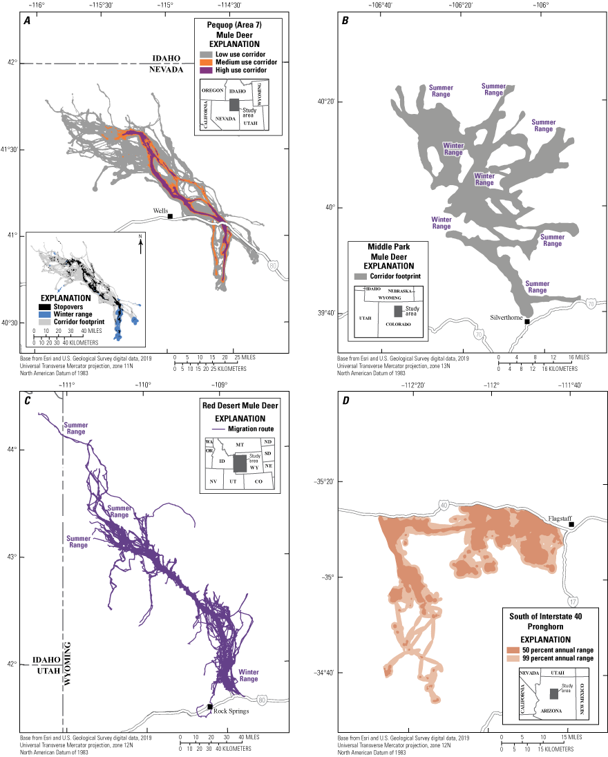
Example maps showing the flexibility in mapping approaches used by partners contributing to the “Ungulate Migrations of the Western United States” report series (modified from Kauffman and others, 2020a, 2022a, c, 2024a, 2025a). Maps of A, low, medium, and high use corridors; B, singular corridor footprints; C, line features representing individual migration routes; and D, year-round ranges showing annual ranges (distributions) have all been used to highlight important areas used by migrating ungulates.
Many agency partners choose to make the migration and seasonal range products (for example, lines of migration routes or polygons of migration corridors and seasonal ranges) available to the public, although it is not a prerequisite for participating in the CMT or the “Ungulate Migrations of the Western United States” report series. Lines of migration routes or polygons of migration corridors and seasonal ranges are made publicly available by the respective State or Tribal agency upon request. GPS locations are not made publicly available through agency involvement in the report series. Sometimes, participating States have State-led repositories where the migration and seasonal range products are publicly available. A rigid approach in requiring a singular analytical method or necessary data sharing would ultimately limit our ability to map ungulate migrations.
The CMT’s highly collaborative approach and regular meetings help further foster a community of practice and maintain an open dialog among the many partners. Regular communication has helped facilitate transboundary mapping of ungulate migrations. For example, volume 5 (Kauffman and others, 2025a) of the report series included three elk herds with winter ranges in Idaho and summer ranges to the south in Nevada. The Nevada Department of Wildlife (NDOW) and Idaho Department of Fish and Game had collected separate datasets by collaring elk in their respective States. In part, through the interstate communication of the CMT, the two State agencies combined their datasets and generated corridors for the three elk herds that spanned the Idaho and Nevada border (fig. 2; Kauffman and others, 2025a). Similarly, this report details the migrations of three Antilocapra americana (pronghorn) herds using the tristate border area of Oregon, Nevada, and California, that were jointly mapped with a combined dataset (refer to the “Sheldon-Hart Mountain Pronghorn,” “Washoe Pronghorn,” and “Surprise Valley Pronghorn” sections of this report). Many other herds in this report also show transboundary movements. Before the creation of the CMT, the few ungulate migration maps that existed often stopped at State or Tribal boundaries. However, migratory animals do not recognize jurisdictional boundaries, so maps using combined datasets can help identify and advance the management of the connected habitats upon which comanaged herds rely.
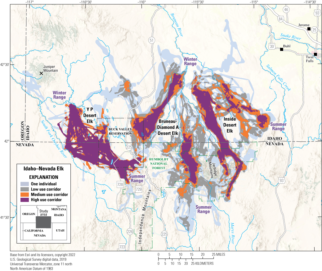
The Y P Desert, Bruneau-Diamond A Desert, and Inside Desert elk herds were jointly mapped by Idaho Department of Fish and Game and Nevada Department of Wildlife and included in volume 5 of the “Ungulate Migrations of the Western United States” report series (modified from Kauffman and others, 2025a). The elk winter in southern Idaho and migrate south in the spring to northern Nevada, where they summer.
Migration was likely more common before the American West was settled, although the historical record is sparse. Early records of trappers and hunters suggest ungulate herds were abundant and migratory (Whittlesey and others, 2017), and archeological data provide evidence of early humans hunting and ambushing ungulates along their migration routes. For example, an archeological site along the Path of the Pronghorn in Wyoming revealed a pronghorn “kill site” that included clear signs of butchering (Miller and others, 1999). The site also included the bones of fetal pronghorn, which indicated that animals were killed in the spring, most likely during migration. Carbon dating places those pronghorn along the modern-day migration corridor 5,000–8,000 years ago (Miller and others, 1999). State, Federal, and Tribal collaborators have made great progress toward a complete map of the migratory herds that currently (2025) exist in the Western United States. However, there is still a poor understanding of migrations that may have been lost because of human settlement and development before the broad use of tracking technology. Additionally, some of today’s (2025) migrations may look different from the seasonal movement patterns presettlement because of population bottlenecks, reintroductions, and human-avoidance behavior that are common to many wildlife species. Nevertheless, the 237 ungulate migrations in the report series are the beginning of a broader inventory of all migrations that exist across the Western United States. Although incomplete, the published maps are useful for guiding on-the-ground conservation efforts necessary to maintain intact and functional migrations. Compiling a more robust inventory of western migrations could be aided by tracking additional animals on the landscapes where ungulate migrations are expected, but where tracking data are currently (2025) lacking. Analyses of additional animals may inform where new tracking projects could best contribute to existing knowledge gaps.
Herd Summaries
The herd-specific maps and associated summary text make up the core content of the USGS “Ungulate Migrations of the Western United States” report series. This section includes maps documenting the migrations and seasonal ranges for 23 Odocoileus hemionus (mule deer), elk, and pronghorn herds from most Western United States and select Tribal lands. The maps in this report were produced in close collaboration with participating State or Tribal agencies that collected and analyzed the GPS-collar data to delineate the migration corridors and seasonal ranges. The specific methods, space-use classifications (for example low, medium, or high use corridors), and data layers (for example, migration routes shown as lines and migration corridors, stopovers, winter ranges, or annual ranges shown as polygons) vary across herds in the report to adhere to agency-specific policies and procedures.
In addition to the herd maps, this section includes project and analytical details, summary statistics for the underlying data, and relevant contacts and reports for each herd. The general workflow for each herd’s data analysis consisted of the following steps: (1) selecting migration dates for each animal year using the Migration Mapper application (Merkle and others, 2022; app. 1), (2) using a BBMM to estimate a utilization distribution (UD) for each migration sequence (Horne and others, 2007; app. 1), (3) averaging the UDs for a given individual’s migration sequences for all years, and (4) stacking the averaged individual UDs for a given herd and defining different levels of migration-corridor use on the basis of the number of individuals using a given pixel or defined area of space. In general, we define “low use” as areas traversed by at least 1 collared individual during migration, “medium use” as areas used by 10–20 percent of collared individuals in the herd, and “high use” as areas used by greater than (>) 20 percent of collared individuals in the herd. Complete descriptions of the methods and herd-specific modifications are included in appendix 1. The data layers for many of the herd maps in this report are also publicly available in the associated USGS data release (Kauffman and others, 2026).
California | Mule Deer
East Walker Mule Deer
East Walker mule deer are mostly traditional migrants that migrate between distinct seasonal ranges in central California near the Nevada border. Their winter range comprises Pinus spp. (pinyon)-Juniperus spp. (juniper) and spans Wovoka Wilderness in Nevada and an area east of State Route 338 in Nevada and State Route 182 in California. In 2019, the herd contained 1,279 mule deer (Tom Stephenson, California Department of Fish and Wildlife, written commun., 2025). In the spring, individuals move west into California using several corridors; however, a concentrated migration corridor parallels the East Walker River, crossing State Route 182 and into the Sweetwater Mountains to the north of Bridgeport Reservoir, ending in the Sierra Nevada (fig. 3). Most deer do not cross into Yosemite National Park, instead summering in the Toiyabe National Forest (part of the Humboldt-Toiyabe National Forest) or Bureau of Land Management (BLM) lands. Migration corridors varied from short (3.96 miles [mi]; 6.38 kilometers [km]) to long (41.54 mi [66.85 km]) distances and migration start dates were variable within and among years.
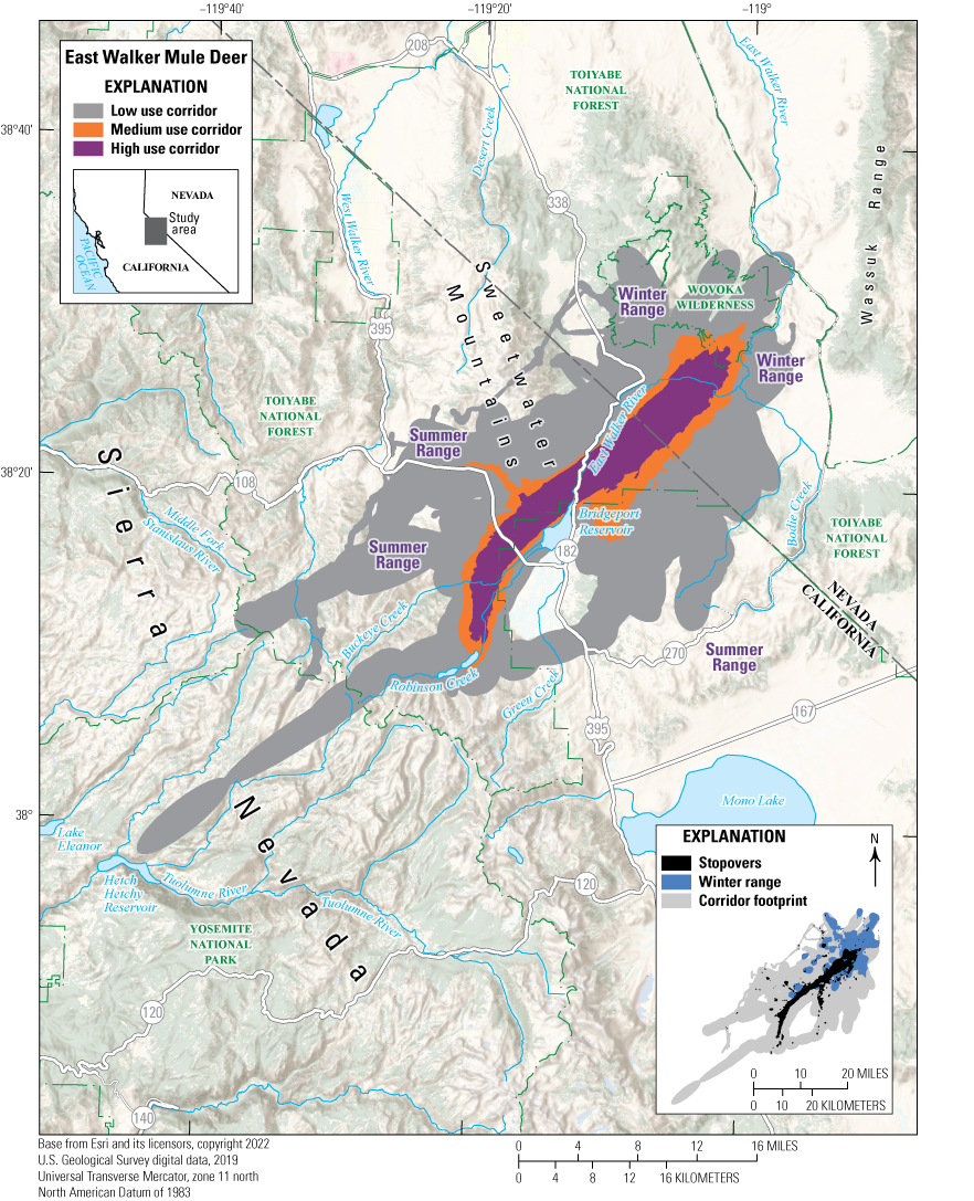
Map showing migration corridors, stopovers, and winter ranges of the East Walker mule deer herd.
Animal Capture and Data Collection
Sample size: 125 adult female mule deer
Relocation frequency: Approximately 1−24 hours
Project duration: 2017–present (data through August 2024 analyzed for this report)
Data Analysis
Corridor, stopover, and winter range analysis: Fixed Motion Variance (McKee and others, 2024; app. 1)
Delineation of migration periods: Net Squared Displacement (Bunnefeld and others, 2011)
Models derived from:
Migration use classifications:Corridor and Stopover Summary
Migration start and end dates (median):
Number of days migrating (mean): Migration corridor length: Migration corridor area:California | Mule Deer
West Walker Mule Deer
West Walker mule deer are mostly traditional migrants in east-central California, near the Nevada border. Their winter range spans Antelope Valley in California and Nevada and stretches across State Route 395 into Slinkard Valley and Little Antelope Valley near Walker, California. In 2019, the herd contained an estimated 3,589 mule deer (Tom Stephenson, California Department of Fish and Wildlife, written commun., 2025). In the spring, individuals move south and west into higher elevations in California using several corridors; however, a concentrated migration corridor parallels the West Walker River, straddling State Routes 395 and 108 to the west of the Sweetwater Mountains and ending in the Sierra Nevada (fig. 4). Most deer do not cross into Yosemite National Park, instead summering in montane forests of Stanislaus and Toiyabe National Forests (part of the Humboldt-Toiyabe National Forest). Some mule deer are multirange migrants, moving among two or more distinct ranges in a single season.
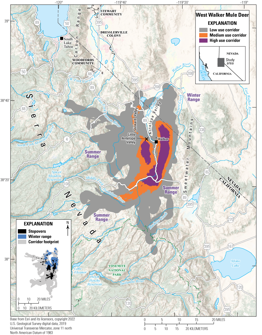
Map showing migration corridors, stopovers, and winter ranges of the West Walker mule deer herd.
Animal Capture and Data Collection
Sample size: 171 adult female mule deer
Relocation frequency: Approximately 1−24 hours
Project duration: 2017–present (data through August 2024 analyzed for this report)
Data Analysis
Corridor, stopover, and winter range analysis: Fixed Motion Variance (McKee and others, 2024; app. 1)
Delineation of migration periods: Net Squared Displacement (Bunnefeld and others, 2011)
Models derived from:
Migration use classifications:Corridor and Stopover Summary
Migration start and end dates (median):
Number of days migrating (mean): Migration corridor length: Migration corridor area:Colorado | Mule Deer
North Park Mule Deer
The North Park mule deer herd (Data Analysis Unit [DAU] D3) inhabits North Park, an intermountain basin on the east side of the Continental Divide in Jackson County, Colorado (fig. 5). Elevations within the DAU range from approximately 7,800 to 13,000 feet (ft; 2,377 to 3962 meters [m]). North Park is bound to the north by the Wyoming border, to the east by the Medicine Bow Mountains and Never Summer Mountains, to the south by the Rabbit Ears Range, and to the west by the Park Range. North Park serves as the headwaters of the North Platte River and contains many drainages, including the Illinois River, Michigan River, Canadian River, and the North Fork of the North Platte River. The North Park basin spans 1.04 million acres (420,873 ha) and features diverse landownership, including 12 percent State, 36 percent private, and 52 percent Federal land (BLM, U.S. Department of Agriculture Forest Service [FS], and U.S. Fish and Wildlife Service).
During the summer, North Park mule deer are dispersed across the entire DAU; higher deer densities are in forested and alpine habitats more than 8,500 ft (2,591 m). Population estimates have historically fluctuated, peaking at 10,000–12,000 deer in the 1950s (Don Gore, Colorado Division of Wildlife, written commun., 2025), though more recent estimates indicate approximately 4,500–6,000 deer (the 2023 posthunt estimate was 5,400 deer; Eric VanNatta, Colorado Parks and Wildlife [CPW], written commun., 2025). Historically, North Park supported a large wintering deer population within the DAU. However, in the early 2000s, CPW staff observed a shift in wintering deer patterns; most deer now migrate from North Park to adjacent winter ranges to the north, east, and south of the DAU. Despite only moderate land-use changes, including the conversion of some Artemisia spp. (sagebrush) habitat to grassland for livestock grazing, North Park still retains quality mule deer winter range, although few, if any, deer now use it. CPW staff hypothesize this shift in winter deer distribution may be a result of past management decisions implemented during the mid-1900s, when a combination of relatively liberal hunting quotas and late-season hunting permitted years of heavy, targeted harvest of deer on local winter range. Because of this management regime, a smaller migratory subset of deer that were less affected by hunter harvest may have experienced higher survival and may have led to migratory behavior becoming more dominant.
The predominance of this migratory behavior poses challenges for managing a stable population. For example, CPW classification survey flights, done annually in late December or early January, coincide with winter conditions that drive deer, elk, and Alces alces (moose) into areas with greater sightability. Surveys from the 1960s to 1970s reported 2,000–3,000 mule deer per year. However, an average of only 250 deer per year have been counted during the past decade (CPW, 2023), likely because most mule deer have already left North Park or are near staging areas along suspected migration routes during the typical survey period. These small sample sizes complicate population modeling, limiting CPW’s ability to accurately estimate population size and detect subtle demographic changes. This challenge has spurred recent research, funded by Secretarial Order 3362, into understanding North Park mule deer migration characteristics.
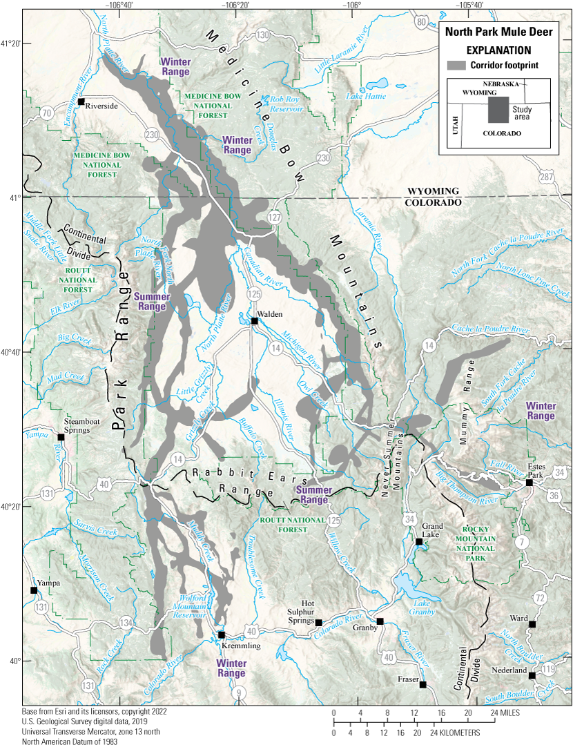
Map showing the migration footprint used by at least one individual of the North Park mule deer herd.
Animal Capture and Data Collection
Sample size: 50 adult female mule deer
Relocation frequency: 4 hours
Project duration: 2021–24 (data from August 2021 through January 2024 analyzed for this report)
Data Analysis
Corridor, stopover, and winter range analysis: Fixed Motion Variance (McKee and others, 2024; app. 1)
Delineation of migration periods: Net Squared Displacement (Bunnefeld and others, 2011)
Models derived from:
Migration use classifications:Corridor Summary
Migration start and end dates (median):
Number of days migrating (mean): Migration corridor length: Migration corridor area:Colorado | Mule Deer
San Juan Basin Mule Deer
The San Juan Basin mule deer herd (DAU D30) inhabits a 2,800-square mile (mi2; 7,252-square kilometer [km2]) area in the southwest corner of Colorado (fig. 6). It is bounded to the north and east by the Continental Divide, to the south by the Colorado and New Mexico border, and to the west by the Animas River. Elevations range from 5,000 ft (1,524 m) to more than 14,000 ft (4,267 m). The DAU encompasses Durango, Bayfield, Ignacio, and Pagosa Springs, Colorado, and landownership is a mix of 30 percent private, 12 percent Southern Ute Indian Tribe of the Southern Ute Reservation, Colorado (hereafter Southern Ute Indian Tribe), 2 percent BLM lands, and 56 percent FS lands.
The San Juan Basin mule deer herd includes migratory and nonmigratory individuals. Deer generally summer at higher elevations in the northern and eastern part of the DAU and winter at lower elevations to the south. The timing of deer migration is consistent annually; peak spring migration occurs approximately during the second week of May, and the peak fall migration occurs approximately during the third week of October. In the fall, males generally migrate 1–2 weeks later than females. Part of the deer herd’s migration corridor and winter range extends onto Southern Ute Indian Tribal lands and into New Mexico. Resident deer remain year round at the lower elevations that are often associated with agriculture fields.
The main threats to the San Juan Basin mule deer herd include human development and associated infrastructure. Energy and recreational development occur on a large part of important habitat for the San Juan mule deer herd and jeopardize their available resources. Development concerns are a region-wide issue, but they pose a greater problem near Durango, Bayfield, and Pagosa Springs, Colorado.
Additionally, the San Juan mule deer herd inhabits an area with some of the highest recorded wildlife-vehicle collisions (WVCs) in the State. Several highways bisect mule deer migration corridors and winter range, including U.S. Highways 160, 84, and 550, and Colorado State Highways 172, 151, 240, and 501. GPS-collar data from female mule deer have helped identify locations where mule deer cross roadways. These data, along with WVC data, have been instrumental in prioritizing where to build wildlife-crossing structures to ease mule deer movement across busy roads. In 2022, the Colorado Department of Transportation (CDOT), the Southern Ute Indian Tribe, CPW, and other partners helped to fund the construction of a wildlife overpass and underpass on a 1.9-mi (3.1-km) section of U.S. Highway 160 near Chimney Rock and the intersection of Colorado State Highway 151. In 2023, a network of camera traps was established to determine the effectiveness of wildlife-crossing structure installations to reduce WVCs and maintain wildlife movement permeability. Within the first 8 months of monitoring (October 2023 through June 2024), mule deer, elk, Ursus americanus (black bears), Puma concolor (mountain lions), and many smaller mammal species successfully used the crossing structures (Cramer, 2024). The CDOT has plans for additional crossing structures as funding becomes available.
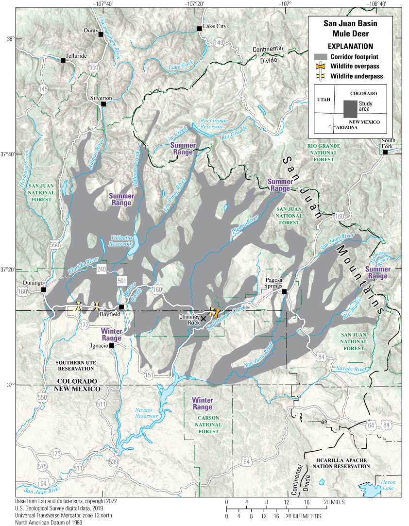
Migration footprint used by two or more individuals in the San Juan Basin mule deer herd.
Animal Capture and Data Collection
Sample size: 194 adult female mule deer
Relocation frequency: Approximately 1–5 hours
Project duration: 2004–22
Data Analysis
Corridor footprint: Brownian bridge movement models (Sawyer and others, 2009)
Delineation of migration periods: Net Squared Displacement (Bunnefeld and others, 2011; app. 1)
Models derived from:
Migration use classifications:Corridor and Stopover Summary
Migration start and end dates (median):
Number of days migrating (mean): Migration corridor length: Migration corridor area:Other Information
Project contacts:
-
• Brad Weinmeister (brad.weinmeister@state.co.us), Terrestrial Biologist, Colorado Parks and Wildlife
-
• Aran Johnson (ajohnson@southernute-nsn.gov), Wildlife Division Head, Southern Ute Indian Tribe
-
• Michelle Cowardin (michelle.cowardin@state.co.us), Wildlife Movement Coordinator, Colorado Parks and Wildlife
Idaho | Mule Deer
Blackrock Canyon Mule Deer
The Blackrock Canyon mule deer herd winters near Pocatello, Idaho. During very severe winters, most deer live within 0.5 mi (1 km) of the Interstate 15 corridor from Inkom, Idaho, to the southeast extent of the Pocatello city limits (fig. 7). During milder winters, deer shift southeast of Pocatello and use a broader winter range covering approximately 27 mi2 (70 km2). Recent aerial abundance surveys indicated that 1,500–2,500 mule deer winter to the southeast of Pocatello. The Interstate 15 corridor is fenced with wildlife-exclusionary fencing from Inkom to Pocatello, and very little movement currently (2025) occurs between the Blackrock Canyon mule deer herd and deer south of the highway. Before 2020, the Blackrock Canyon mule deer winter range was considered part of the Bannock mule deer herd to the southwest. However, as more GPS-collar data were collected, it became clear that the winter range of this herd had little connectivity to those southwestern areas and, instead, was integrally connected to summer ranges to the north and east. Blackrock Canyon mule deer travel to the east–northeast through the Fort Hall Reservation to the Portneuf Range, Chesterfield Range, the foothills of the Grays Range, and near the Blackfoot Reservoir. In the winter range, wildfire has degraded the lowest-elevation areas, and nonnative, invasive annual grasses have flourished. Fencing, WVCs, urban sprawl, and connectivity are also concerns for this herd. In the summer range, human-caused resource extraction and Populus tremuloides (quaking aspen) stand invasion by Pseudotsuga menziesii (Douglas fir) continue to challenge and degrade nutrient-rich summer habitats.
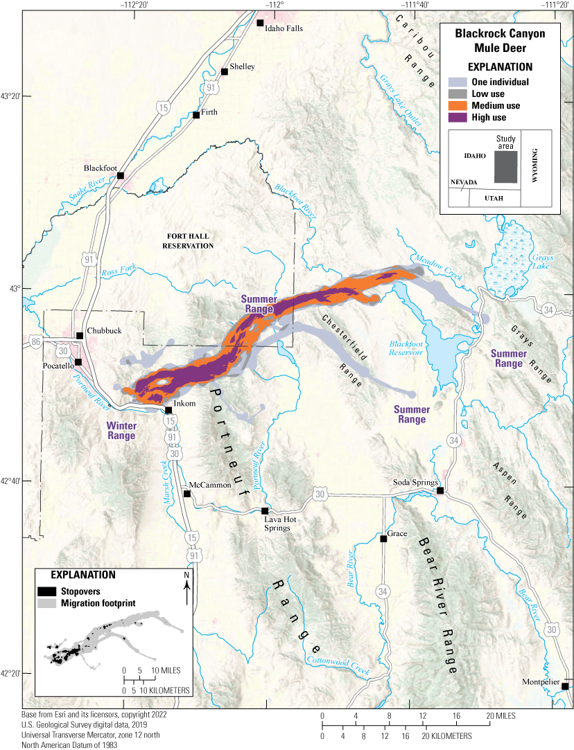
Map showing migration routes and stopovers of the Blackrock Canyon mule deer herd.
Animal Capture and Data Collection
Sample size: 26 adult female mule deer
Relocation frequency: Approximately 4 hours
Project duration: 2023−24
Data Analysis
Migration route and stopover analysis: Brownian bridge movement models (Sawyer and others, 2009) with an 8-hour time lag
Delineation of migration periods: Net Squared Displacement (Bunnefeld and others, 2011)
Models derived from:
Migration use classifications:Migration Route and Stopover Summary
Migration start and end dates (median):
Number of days migrating (mean): Migration route length: Migration route area:Other Information
Idaho migration routes are updated and viewable by Idaho Department of Fish and Game (Idaho Department of Fish and Game, 2024). Mapping layers shown for this herd are sensitive but may be made available to researchers upon request by contacting Idaho Department of Fish and Game (idfgdatarequests@idfg.idaho.gov).
Project contacts:
-
• Matt Mumma (matt.mumma@idfg.idaho.gov), Wildlife Research Manager, Idaho Department of Fish and Game
-
• Jacob Gray (jacob.gray@idfg.idaho.gov), Natural Resources Program Coordinator Habitat and Migration, Idaho Department of Fish and Game
-
• Zach Lockyer (zach.lockyer@idfg.idaho.gov), Regional Wildlife Populations Manager, Idaho Department of Fish and Game
-
• Eric Freeman (eric.freeman@idfg.idaho.gov), Regional Wildlife Populations Biologist, Idaho Department of Fish and Game
-
• Scott Bergen, Senior Wildlife Research Biologist, Idaho Department of Fish and Game
-
• Robert Ritson, Associate Research Scientist, Wyoming Cooperative Fish and Wildlife Research Unit, Department of Zoology and Physiology, University of Wyoming
-
• Meints, D., Ward, R., Knetter, J., Miyasaki, H., Oelrich, K., Mosby, C., Ellstrom, M., Roche, E., Elmer, M., Crea, S., Smith, D., Hribik, D., Hickey, C., Berkley, R., McDonald, M., Lockyer, Z., Hendricks, C., Painter, G., and Newman, D., 2020, F19AF00858 statewide surveys and inventory final performance report: Boise, Idaho, Idaho Department of Fish and Game, 20 p. [Also available at https://idfg.idaho.gov/data/request.]
-
• Roberts, S., and Mumma, M., 2023, F22AF03552 statewide wildlife research final performance report: Boise, Idaho, Idaho Department of Fish and Game, 48 p.
Idaho | Mule Deer
Hells Canyon Mule Deer
The Hells Canyon mule deer herd consists of 3,000–5,000 deer that winter primarily in sagebrush-steppe habitat adjacent to the Snake River and near the Brownlee and Oxbow dams (fig. 8). The area is dominated by steep canyons with grasslands and sagebrush-steppe habitat at lower elevations and on south-facing slopes and pine at higher elevations. Most of this herd summers at high elevations in the management unit, to the northwest of Cambridge and west of Council, Idaho. However, a large part of this herd winters farther east, south of New Meadows, Idaho, where it overlaps with the Weiser mule deer herd and migrants from areas around Riggins, Idaho. Additionally, several Hells Canyon mule deer cross the Snake River between Oregon and Idaho during their seasonal migrations. Hells Canyon mule deer face multiple challenges along their migration routes, including crossing State Highway 95, Idaho’s primary north–south highway, increased energy and mining development, and navigating a matrix of private and public lands. Frequent, large wildfires degrade winter range quality and promote the establishment of invasive annual grasses on winter and summer ranges.
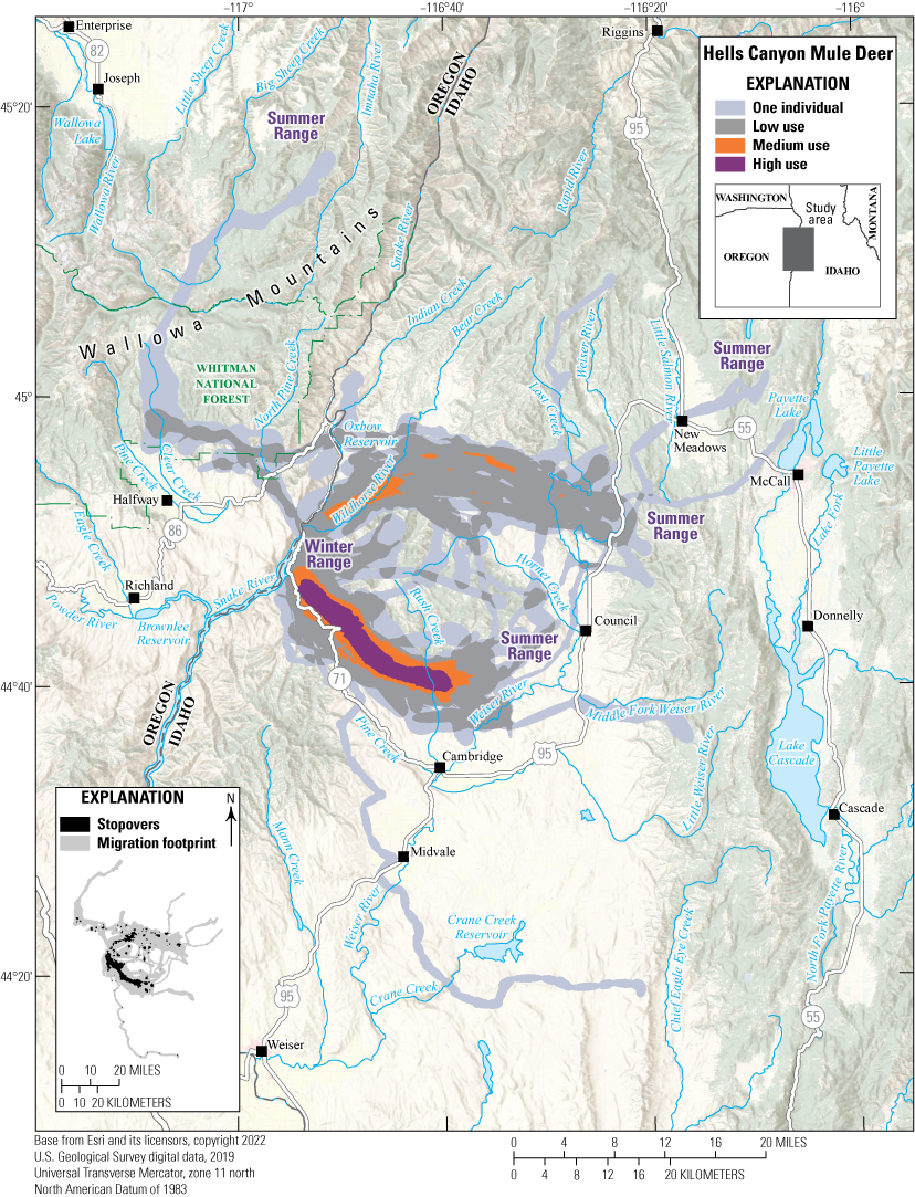
Map showing migration routes and stopovers of the Hells Canyon mule deer herd.
Animal Capture and Data Collection
Sample size: 74 female mule deer
Relocation frequency: 4–12.5 hours
Project duration: 2015–24
Data Analysis
Migration route and stopover analysis: Brownian bridge movement models (Sawyer and others, 2009) with an 8-hour time lag for 61 migration sequences, Fixed Motion Variance (11,840 square feet [ft2]; 1,100 square meters [m2]; McKee and others, 2024) with a 14-hour time lag for 59 migration sequences, and Fixed Motion Variance (11,840 ft2 [1,100 m2]; McKee and others, 2024) with a 27-hour time lag for 9 migration sequences (app. 1)
Delineation of migration periods: Net Squared Displacement (Bunnefeld and others, 2011)Models derived from:
Migration use classifications:Migration route and Stopover Summary
Migration start and end dates (median):
Number of days migrating (mean): Migration corridor length: Migration route area:Other Information
Idaho migration routes are updated and viewable by Idaho Department of Fish and Game (Idaho Department of Fish and Game, 2024). Mapping layers shown for this herd are sensitive but may be made available to researchers upon request by contacting Idaho Department of Fish and Game (idfgdatarequests@idfg.idaho.gov).
Project contacts:
-
• Matt Mumma (matt.mumma@idfg.idaho.gov), Wildlife Research Manager, Idaho Department of Fish and Game
-
• Jacob Gray (jacob.gray@idfg.idaho.gov), Natural Resources Program Coordinator Habitat and Migration, Idaho Department of Fish and Game
-
• Regan Berkley (regan.berkley@idfg.idaho.gov), Regional Wildlife Populations Manager, Idaho Department of Fish and Game
-
• Nathan Borg (nathan.borg@idfg.idaho.gov), Regional Wildlife Populations Biologist, Idaho Department of Fish and Game
-
• Scott Bergen, Senior Wildlife Research Biologist, Idaho Department of Fish and Game
-
• Robert Ritson, Associate Research Scientist, Wyoming Cooperative Fish and Wildlife Research Unit, Department of Zoology and Physiology, University of Wyoming
-
• Meints, D., Ward, R., Knetter, J., Miyasaki, H., Oelrich, K., Mosby, C., Ellstrom, M., Roche, E., Elmer, M., Crea, S., Smith, D., Hribik, D., Hickey, C., Berkley, R., McDonald, M., Lockyer, Z., Hendricks, C., Painter, G., and Newman, D., 2020, F19AF00858 statewide surveys and inventory final performance report: Boise, Idaho, Idaho Department of Fish and Game, 20 p. [Also available at https://collaboration.idfg.idaho.gov/WildlifeTechnicalReports/F19AF00858%20Statewide%20Surveys%20%20Inventory%20Final%20Report%20FY20.pdf.]
-
• Roberts, S., and Mumma, M., 2023, F22AF03552 statewide wildlife research final performance report: Boise, Idaho, Idaho Department of Fish and Game, 48 p.
Navajo Nation | Mule Deer
Canyon de Chelly Mule Deer
The Canyon de Chelly mule deer herd is one of several herds that winter in the foothills of the Chuska Mountains, an 80-mile (129-km) long range within the southeastern Colorado Plateau in Navajo Nation, Arizona, New Mexico, & Utah (hereafter Navajo Nation). Initially included in Kauffman and others (2022a), this herd has been updated for this report with data from additional years. The winter ranges and migration corridors of the Canyon de Chelly herd are just 7 mi (11 km) south of the Ram Pasture herd (refer to the “Ram Pasture Mule Deer” section of this report) but are separated geographically by Canyon del Muerto and Black Rock Canyon (fig. 9). These canyons are part of the larger Canyon de Chelly National Monument. Unlike other federally managed parks, the monument is comanaged with a Native American Tribe, whereas all parklands remain Navajo Nation Tribal trust land (National Park Service, 2025). Members of the Navajo Nation continue to reside in and around the canyons, maintaining livestock and cultivating crops. Although the canyon has accessible routes and perennial streams, GPS-collared mule deer primarily winter on the canyon mesas. Windmills installed by the Navajo Nation Department of Water Resources for livestock also provide a critical water source for mule deer in winter. During spring and fall migrations, the Canyon de Chelly herd crosses Indian Route 12, a heavily traveled rural highway along the Arizona and New Mexico border. The primary challenges the herd faces during migration include vehicular collisions, urban development, and overgrazing by feral horses and unregulated livestock.
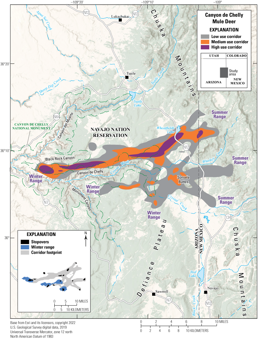
Map showing migration corridors, stopovers, and winter ranges of the Canyon de Chelly mule deer herd.
Animal Capture and Data Collection
Sample size: 8 adult female mule deer
Relocation frequency: Approximately 1–4 hours
Project duration: 2018–24
Data Analysis
Corridor and winter range analysis: Fixed Motion Variance (McKee and others, 2024; app. 1)
Delineation of migration periods: Net Squared Displacement (Bunnefeld and others, 2011)
Models derived from:
Migration use classifications:Corridor and Stopover Summary
Migration start and end dates (median):
Number of days migrating (mean): Migration corridor length: Migration corridor area:Navajo Nation | Mule Deer
Ram Pasture Mule Deer
The Ram Pasture mule deer herd is one of several herds that winter in the foothills of the 80-mi (129-km) long Chuska Mountains in Navajo Nation (fig. 10). This herd was originally included in Kauffman and others (2022a) and has been updated for this report to include new data from additional years and mule deer (12 new adults; Kauffman and others, 2022a). These mule deer winter in pinyon-juniper and sagebrush foothills; migrate to the east to higher elevations in the spring; and summer in habitats comprised of mixed conifer, aspen, high alpine meadows, and Pinus ponderosa (ponderosa pine). Winter and summer ranges remain entirely within Tribal trust lands managed by the Navajo Nation Department of Fish and Wildlife. Similar to the Canyon de Chelly mule deer herd (refer to the “Canyon de Chelly Mule Deer” section of this report), every spring and fall, the Ram Pasture herd must cross Indian Route 12, a busy rural highway along the Arizona and New Mexico border. During migration seasons, WVCs are a continuous problem in these areas. In 2023, aerial surveys estimated 1,030 mule deer as the minimum number of known alive deer throughout their winter ranges in the Chuska Mountains, which is a decline from the 2020 estimate of 1,583 mule deer (Kauffman and others, 2022a). The limiting factors for this herd include low-quality habitat caused by overgrazing and resource competition with feral horses and unregulated livestock (Davies and Boyd, 2019; Wallace and others, 2021). Furthermore, extended drought and habitat fragmentation driven by urban development have accelerated the decline of habitat suitability (Redsteer and others, 2018; Nania and others, 2014).
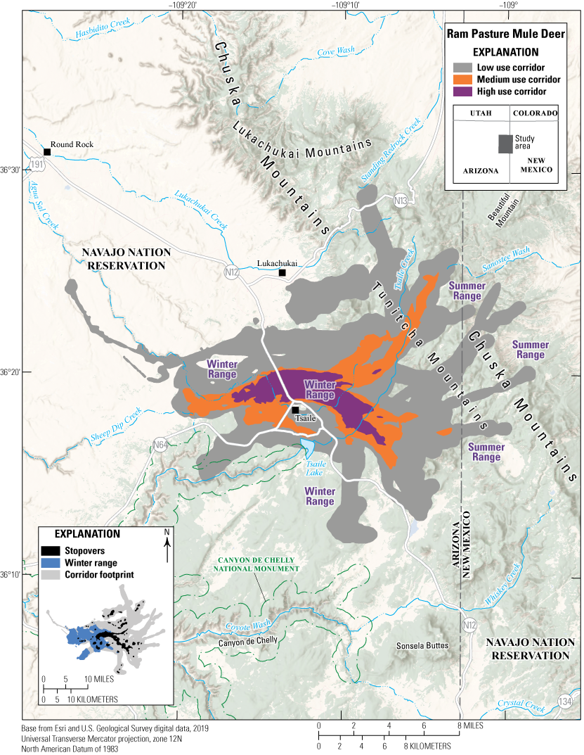
Map showing migration corridors, stopovers, and winter ranges of the Ram Pasture mule deer herd.
Animal Capture and Data Collection
Sample size: 44 adult mule deer (20 males, 24 females)
Relocation frequency: Approximately 1–4 hours
Project duration: 2018–24
Data Analysis
Corridor and winter range analysis: corridor analysis used Fixed Motion Variance (McKee and others, 2024; app. 1)
Delineation of migration periods: Net Squared Displacement (Bunnefeld and others, 2011)
Models derived from:
Migration use classifications:Corridor and Stopover Summary
Migration start and end dates (median):
Number of days migrating (mean): Migration corridor length: Migration corridor area:Nevada | Mule Deer
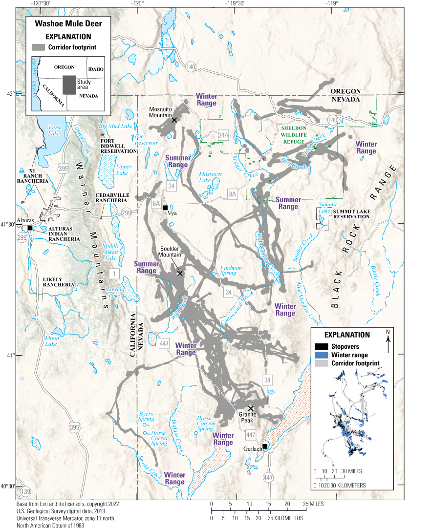
Washoe Mule Deer
The Washoe mule deer herd inhabits the northwest corner of Nevada, northeastern California, and southern Oregon (fig. 11). The Washoe mule deer herd spans seven of Nevada Department of Wildlife (NDOW)’s Hunt Units (011–015, 032–033) and consists of long-distance and short-distance migrants; some deer travel more than 62 mi (100 km), and other deer travel less than 0.5 mi (1 km) downslope to lower elevations during the winter. The Washoe mule deer herd comprises several subherds, including the Mosquito Mountain, Sheldon National Wildlife Refuge, Vya, Boulder Mountain, and Granite Peak mule deer. Over the past 10 years, the Washoe mule deer herd has declined drastically, largely because of the long-term effects of drought. Other threats this herd faces include fencing, habitat loss from wildfires, the conversion of shrublands to annual grasses, and competition with feral horses for forage and water. Several habitat projects have been initiated to help manage these mule deer subherds, including spring protection projects in Hunt Unit 013 near Findman Spring and Horse Canyon Spring, and in Hunt Unit 015 near Horse Corral and Byers Springs. Additionally, approximately 7.5 mi. (12 km) of fencing improvements have been made along the California border near Big Mud Lake and Fee Reservoir (NDOW, 2024).
Map showing migration corridors, stopovers, and winter ranges of the Washoe mule deer herd.
Animal Capture and Data Collection
Sample size: 89 adult mule deer (9 males, 80 females)
Relocation frequency: Approximately 3.5−8 hours
Project duration: 2008−09 and 2018−present (data through June 2024 analyzed for this report)
Data Analysis
Corridor, stopover, and winter range analysis: Brownian bridge movement models (Sawyer and others, 2009) and Fixed Motion Variance (McKee and others, 2024; app. 1)
Delineation of migration periods: Net Squared Displacement (Bunnefeld and others, 2011)
Models derived from:
Migration use classifications:Corridor and Stopover Summary
Migration start and end dates (median):
Number of days migrating (mean): Migration corridor length: Migration corridor area:Other Information
Project contacts:
-
• Jon Ewanyk (jon.ewanyk@ndow.org), Game Biologist, Nevada Department of Wildlife
-
• Cody Schroeder (cschroeder@ndow.org), Mule Deer Staff Specialist, Nevada Department of Wildlife
-
• Jaron Kolek, Associate Research Scientist, Wyoming Cooperative Fish and Wildlife Research Unit, Department of Zoology and Physiology, University of Wyoming
-
• Nevada Department of Wildlife, 2024, Nevada State action plan—Implementation of Department of Interior [sic] Secretarial Order 3362—Improving habitat quality in western big-game winter range and migration corridors: Western Association of Fish and Wildlife Agencies, 26 p. [Also available at https://wafwa.org/wp-content/uploads/2024/10/NV-State-Action-Plan-for-SO-3362.pdf.]
Utah | Mule Deer
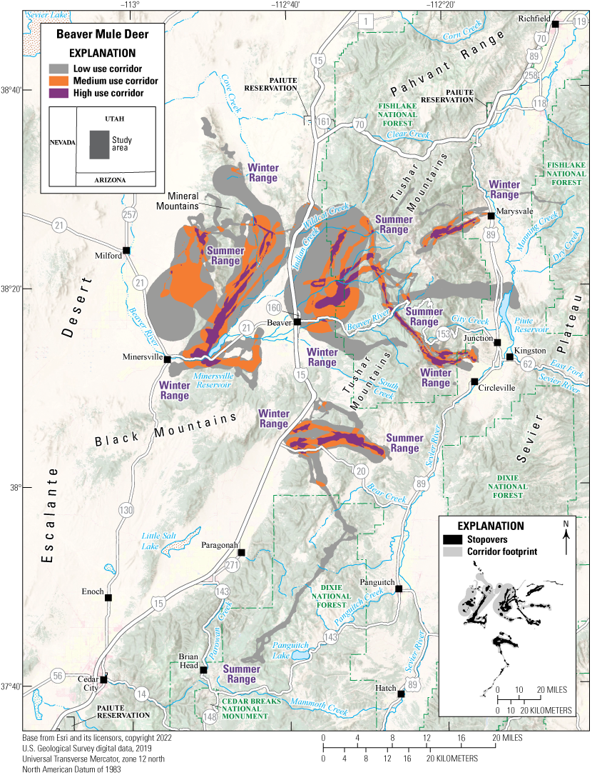
Beaver Mule Deer
The Beaver mule deer herd inhabits the Beaver Wildlife Management Unit (WMU) in southern Utah and includes three mountain ranges: the Tushar Mountains in the east and the Mineral and Black Mountains in the west (fig. 12). The WMU encompasses more than 885,000 acres (358,147 ha) of mule deer range and has approximately 12,000 mule deer (Utah Division of Wildlife Resources [UDWR], 2020b). The area is mostly rural, and landownership consists mainly of BLM and FS lands (UDWR, 2020b). The Beaver mule deer herd is migratory; most deer summer in high elevations on the Tushar Mountains, but some use limited summer range on the Mineral and Black Mountains. Mule deer winter in the lower-elevation slopes of all three mountain ranges. Most mule deer habitat in this WMU is made up of pinyon-juniper woodland (38 percent) and sagebrush-steppe and shrublands (27 percent; Payne and others, 2023). However, widespread encroachment of pinyon and juniper into sagebrush shrublands has decreased available food sources for Beaver mule deer.
Other challenges this herd faces include drought conditions, which much of the Beaver WMU has experienced for 68 percent of the time since 1993 (Payne and others, 2023). Several major roads with high traffic densities pass through this WMU, resulting in concentrated WVCs along sections of Interstate 15, State Route 20, and State Route 21 (Payne and others, 2023). Several mitigation measures have been installed in these areas, including five wildlife crossings and mesh wire exclusionary fencing along Interstate 15 and Interstate 70, which have begun to reduce these WVC effects (Payne and others, 2023). The UDWR uses the GPS data of this herd to describe migration corridors and determine crucial habitats.
Map showing migration corridors and stopovers of the Beaver mule deer herd.
Animal Capture and Data Collection
Sample size: 46 adult mule deer (1 male, 44 females, 1 unknown)
Relocation frequency: Approximately 2–13 hours
Project duration: 2016–21
Data Analysis
Corridor and stopover analysis: Brownian bridge movement models (Sawyer and others, 2009) and Fixed Motion Variance (McKee and others, 2024; app. 1)
Delineation of migration periods: Net Squared Displacement (Bunnefeld and others, 2011)
Models derived from:
Migration use classifications:Corridor and Stopover Summary
Migration start and end dates (median):
Number of days migrating (mean): Migration corridor length: Migration corridor area:Other Information
Utah mule deer migration corridors are viewable and available for download at the Utah Division of Wildlife Resources Wildlife Migration Initiative web page (UDWR, 2025). Data used in this report may be made available upon request by contacting Utah Division of Wildlife Resources.
Project contacts:
Data analyst:Utah | Mule Deer
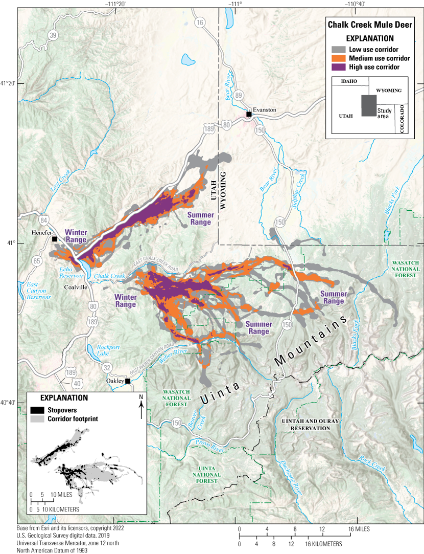
Chalk Creek Mule Deer
The Chalk Creek mule deer herd inhabits the Chalk Creek WMU in northern Utah, northeast of Salt Lake City, Utah, and abuts the Wyoming border (fig. 13). The WMU is bordered to the east by the Uinta Mountains and to the west by the Weber River and two State park reservoirs, Echo Reservoir and Rockport Lake. It encompasses 380,608 acres (154,027 ha) of mule deer range and has approximately 11,250 mule deer (UDWR, 2023b). Landownership is primarily private (88 percent summer range, 96 percent winter range), which makes management of critical mule deer habitat challenging for UDWR (UDWR, 2023b). The Chalk Creek mule deer herd is migratory; deer use high-elevation habitat on private and FS lands in the summer, and limited low-elevation habitats on mostly private lands in the winter. Habitat vegetation types in this WMU include sagebrush–grass, Quercus gambelii (oak brush), and juniper, and 43 percent of the WMU consists of shrubland cover (Payne and others, 2021).
Winter range is limited and threatened by development, agriculture, oil and gas infrastructure, juniper encroachment, and overuse by large elk herds (Payne and others, 2021; UDWR, 2023b). Additionally, Echo Reservoir and Rockport Lake hinder mule deer movement on the west side of the herd’s range. A high number of WVCs occur along Interstate 80 near the reservoirs, particularly along Echo Reservoir where a high use migration corridor intersects Interstate 80 (Payne and others, 2021). The UDWR works closely with the Utah Department of Transportation to prevent WVCs in this unit through fence installation, construction of wildlife escape ramps, and inclusion of wildlife underpasses (UDWR, 2023b). The UDWR uses the GPS data of this herd to describe migration corridors and identify crucial habitats.
Map showing migration corridors and stopovers of the Chalk Creek mule deer herd.
Animal Capture and Data Collection
Sample size: 65 adult mule deer (18 males, 47 females)
Relocation frequency: Approximately 2 hours
Project duration: 2016–22
Data Analysis
Corridor and stopover analysis: Brownian bridge movement models (Sawyer and others, 2009) and Fixed Motion Variance (McKee and others, 2024; app. 1)
Delineation of migration periods: Net Squared Displacement (Bunnefeld and others, 2011)
Models derived from:
Migration use classifications:Corridor and Stopover Summary
Migration start and end dates (median):
Number of days migrating (mean): Migration corridor length: Migration corridor area:Other Information
Utah mule deer migration corridors are viewable and available for download at the Utah Division of Wildlife Resources Wildlife Migration Initiative web page (UDWR, 2025). Data used in this report may be made available upon request by contacting Utah Division of Wildlife Resources.
Project contacts:
Data analyst:Utah | Mule Deer
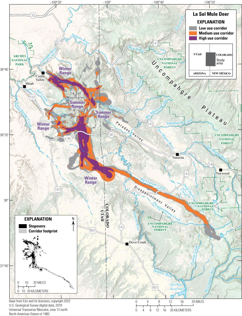
La Sal Mule Deer
The La Sal mule deer herd inhabits the La Sal WMU in southeastern Utah, abutting the Colorado border (fig. 14). Southeastern Utah has varied geography, including a section of the Disappointment Valley, the Colorado River, La Sal Mountains, Arches National Park, and part of Uncompahgre National Forest in western Colorado. The elevation ranges from 4,000 ft (1,219 m) at the lowest point to 12,721 ft (3,877 m) at the highest point (Payne and others, 2019). It encompasses 507,156 acres (205,239 ha) of mule deer range, mostly on and around La Sal Mountains, and has approximately 5,100 mule deer (UDWR, 2020a). Land is primarily managed by the BLM in the winter range (73 percent) and FS in the summer range (57 percent). The annual range is made up of National Park Service lands (41 percent) and BLM lands (46 percent; UDWR, 2020a). The La Sal mule deer herd is migratory; animals use high-elevation slopes in La Sal Mountains in the summer and mesas at 8,000 ft (2,438 m) or lower in the winter, which are all on the east side of the WMU. About 60 percent of the unit comprises shrublands, including Coleogyne ramosissima (blackbrush), a key browse species for mule deer, but most of these areas are not considered mule deer habitat (Payne and others, 2019). The herd faces several challenges, including habitat quality and quantity, pinyon-juniper encroachment, and wildlife-unfriendly fences and crossings that reduce ranges (Payne and others, 2019). The La Sal WMU has the highest prevalence of chronic wasting disease (CWD) in the State; CWD increased in prevalence from 7.9 percent to 14.1 percent between 2015 and 2020 (UDWR, 2020a). The UDWR uses the GPS data of this herd to describe migration corridors, identify crucial habitats, and determine CWD transmission risk.
Map showing migration corridors and stopovers of the La Sal mule deer herd.
Animal Capture and Data Collection
Sample size: 57 adult mule deer (12 males, 45 females)
Relocation frequency: Approximately 2–22 hours
Project duration: 2020–21
Data Analysis
Corridor and stopover analysis: Brownian bridge movement models (Sawyer and others, 2009) and Fixed Motion Variance (McKee and others, 2024; app. 1)
Delineation of migration periods: Net Squared Displacement (Bunnefeld and others, 2011)
Models derived from:
Migration use classifications:Corridor and Stopover Summary
Migration start and end dates (median):
Number of days migrating (mean): Migration corridor length: Migration corridor area:Other Information
Utah mule deer migration corridors are viewable and available for download at the Utah Division of Wildlife Resources Wildlife Migration Initiative web page (UDWR, 2025). Data used in this report may be made available upon request by contacting Utah Division of Wildlife Resources.
Project contacts:
Data analyst:Utah | Mule Deer
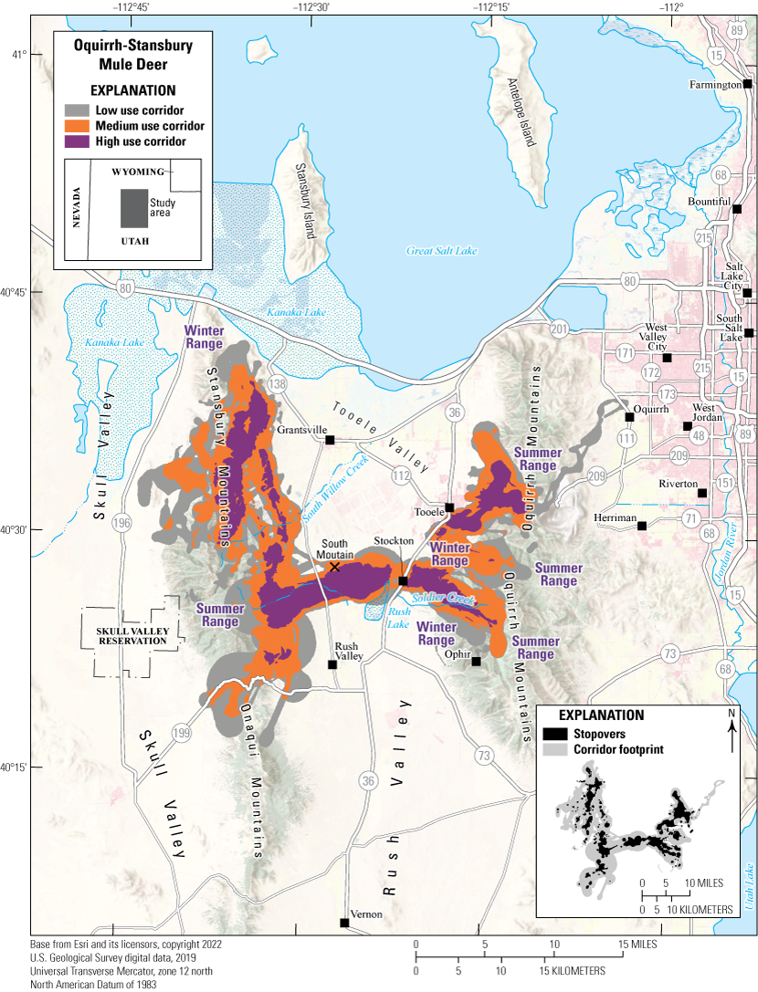
Oquirrh-Stansbury Mule Deer
The Oquirrh-Stansbury mule deer herd inhabits the Oquirrh-Stansbury WMU in north-central Utah, south of the Great Salt Lake (fig. 15). The WMU includes parts of Salt Lake City, Tooele, Grantsville, and Stockton, Utah, and two mountain ranges: the Stansbury Mountains to the west and the Oquirrh Mountains to the east. It encompasses 449,582 acres (181,939 ha) of mule deer range and has approximately 9,900 mule deer (UDWR, 2023a). Landownership is a mix of private (38.2 percent summer range, 38.6 percent winter range), BLM (27.3 percent summer range, 31.3 percent winter range), and FS (28.8 percent summer range, 7.2 percent winter range) lands (UDWR, 2023a). In the fall, deer migrate from high-elevation summer ranges to low-elevation winter ranges surrounding the Stansbury and Oquirrh Mountains. A small part of the winter habitat and migration corridors overlap with developed areas in the WMU. On the west side of the unit, habitat consists primarily of shrubland (36 percent) and a mix of mostly developed, agricultural, open water, and sparsely vegetated areas (24 percent; Payne and others, 2021). On the east side of the WMU, only 23 percent of the habitat is shrubland, and 57 percent is a mix of developed, agricultural, open water, and sparsely vegetated areas (Payne and others, 2021). The herd faces several challenges, including winter range habitat conditions and habitat degradation and loss due to housing development, mining, and pinyon-juniper encroachment on sagebrush rangelands (Payne and others, 2021). Additionally, deer fences and crossings may limit deer ranges, emphasizing the importance of agency collaborations to ensure habitat access for deer and human safety (Payne and others, 2021). The UDWR uses the GPS collar data of this population to monitor mule deer survival, describe migration corridors, and identify crucial habitats.
Map showing migration corridors and stopovers of the Oquirrh-Stansbury mule deer herd.
Animal Capture and Data Collection
Sample size: 90 adult mule deer (22 males, 68 females)
Relocation frequency: Approximately 2–24 hours
Project duration: 2016–21
Data Analysis
Corridor and stopover analysis: Brownian bridge movement models (Sawyer and others, 2009) and Fixed Motion Variance (McKee and others, 2024; app. 1)
Delineation of migration periods: Net Squared Displacement (Bunnefeld and others, 2011)
Models derived from:
Migration use classifications:Corridor and Stopover Summary
Migration start and end dates (median):
Number of days migrating (mean): Migration corridor length: Migration corridor area:Other Information
Utah mule deer migration corridors are viewable and available for download at the Utah Division of Wildlife Resources Wildlife Migration Initiative web page (UDWR, 2025). Data used in this report may be made available upon request by contacting Utah Division of Wildlife Resources.
Project contacts:
Data analyst:Wyoming | Mule Deer
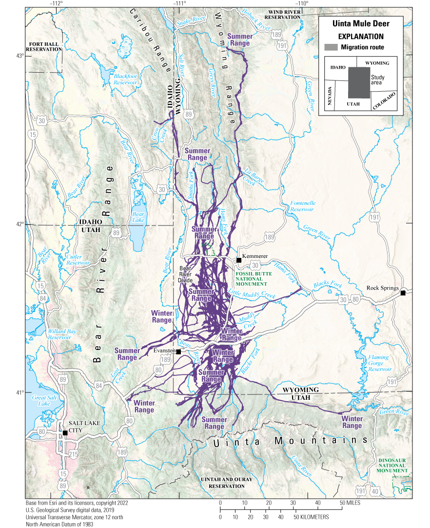
Uinta Mule Deer
Between 2021 and 2024, the Wyoming Cooperative Fish and Wildlife Research Unit at the University of Wyoming and the Wyoming Game and Fish Department (WGFD) conducted a GPS-collaring study to further understand the movement patterns and habitat use of mule deer near Evanston, Wyoming (fig. 16). To gain additional insight into the potential effects of U.S. Highway 189 and Interstate 80 on deer movements, wildlife cameras were used to monitor crossing structures along these highways. Almost 7,000 deer crossings were documented during the winter of 2021–22. New underpasses and a potential overpass to mitigate WVCs are planned for the section of U.S. Highway 189 north of its intersection with Interstate 80. The GPS-collar data collected from this study will likely be used to help the Wyoming Department of Transportation and other agency partners appropriately site these crossing structures to conserve mule deer migrations and reduce WVCs.
Most of the mule deer in the Uinta herd winter in the flats and hills to the north, east, and south of the intersection of U.S. Highway 189 and Interstate 80. Winter range is characterized by Juniperus osteosperma (Utah juniper) and sagebrush species, including Artemisia tridentata ssp. wyomingensis (Wyoming big sagebrush) that occupies most upland sites, Artemisia tridentata ssp. tridentata (basin big sagebrush) in ephemeral drainages and terraces adjacent to riparian areas, Artemisia arbuscula ssp. longiloba (early sagebrush) in upland sites with clay soils, and Artemisia nova (black sagebrush) on shallow soil and gravelly sites. Migrations of these mule deer extend from their winter ranges north into the Wyoming Range, west into the foothills of northeastern Utah, and south into the foothills of the Uinta Mountains. During migration, mule deer must navigate linear barriers such as Interstate 80, U.S. Highway 189, and Wyoming State Highway 89, which can lead to WVCs. Mule deer summer ranges along the Bear River Divide, foothills of the Uinta Mountains, and lower elevations of the Wyoming Range comprise mixed mountain shrubs and aspen habitat. Mountain shrub species consist of Artemisia tridentata ssp. vaseyana (mountain big sagebrush), Purshia tridentata (antelope bitterbrush), Amelanchier alnifolia (western serviceberry), Cercocarpus montanus (true mountain mahogany), and Symphoricarpos albus (common snowberry). Healthy aspen understories include species such as Geranium viscosissimum (sticky geranium), Ligusticum porteri (Porter’s licorice-root), Elymus glaucus (blue wildrye), and Bromus marginatus (mountain brome). High-elevation summer ranges comprise conifer stands as well as tall forb and alpine meadow communities.
Map showing migration routes of the Uinta mule deer herd.
Animal Capture and Data Collection
Sample size: 116 adult female mule deer
Relocation frequency: Approximately 2 hours
Project duration: 2021–24
Data Analysis
Delineation of migration periods: Net Squared Displacement (Bunnefeld and others, 2011; app. 1)
Models derived from:
Corridor and Stopover Summary
Migration start and end dates (median):
Number of days migrating (mean): Migration corridor length:Other Information
Project contacts:
-
• Matthew Kauffman (mkauffm1@uwyo.edu), U.S. Geological Survey, Wyoming Cooperative Fish and Wildlife Research Unit, Department of Zoology and Physiology, University of Wyoming
-
• Sean Yancey (sean.yancey@wyo.gov), Wildlife Management Coordinator, Wyoming Game and Fish Department
-
• Jeff Short (jeff.short@wyo.gov), Wildlife Biologist, Wyoming Game and Fish Department
-
• Bill Rudd (billrudd2@gmail.com), Project Manager and Cofounder, Wyoming Migration Initiative
Wyoming | Mule Deer
Upper Wind River Mule Deer
The Upper Wind River mule deer herd is a larger aggregate of the Dubois, Wind River, and Owl Creek herds, which were included in previous volumes of the report series (Kauffman and others, 2020a, 2022a). Upper Wind River deer migrate varying distances, ranging from 5 to 90 mi (8 to 144 km) between their winter and summer ranges. Short-distance migrations are largely elevational from winter ranges on the lowlands along the Wind River to summer ranges in the Wind River Range (fig. 17). Many deer migrate longer distances into the heart of the Greater Yellowstone Ecosystem, including Yellowstone and Grand Teton National Parks. Mule deer in this migration corridor winter on habitats in the upper Wind River valley under the jurisdiction and sovereignty of the Eastern Shoshone Tribe of the Wind River Reservation, Wyoming, and Northern Arapaho Tribe of the Wind River Reservation, Wyoming (hereafter Wind River Reservation) and surrounding State, Federal, and private lands. Winter ranges are a mix of shrubs, herbaceous grasslands, riparian habitats, and mixed vegetation types associated with agriculture. Summer ranges on the surrounding national forests and national parks are predominantly Pinus contorta (lodgepole pine) montane forests with smaller areas of open herbaceous sagebrush–grasslands, and subalpine forests and grasslands at higher elevations in the Teton Range.
Though the herd has declined, it is one of the few mule deer herds in the State that has not experienced a large decline in recent decades. This relative stability of the herd may be partly because the herd continues to use intact migration routes and winter ranges each year, as it has for generations. Winter ranges and the migrations of this herd often cross U.S. Highway 26/287, which is the highest priority area in Wyoming for reducing WVCs (Wyoming Wildlife and Roadways Initiative, 2019). Additionally, part of the larger herd moves through residential subdivisions near Dubois, Wyoming, including undeveloped private lands. Recognizing the value of this migration, regional partners have collaborated to collect GPS data and track the herd’s movements. In 2024, the WGFD identified the migration corridor as part of Governor Gordon’s Migration Corridor Executive Order 2020–1 (State of Wyoming, 2020). Although the Wind River Reservation provides critical winter, migratory, and stopover habitat, the WGFD’s identified corridor ends at the reservation boundary to respect the sovereignty of the Tribes. Volumes 1 and 2 of the report series (Kauffman and others, 2020a, 2022a) detail the full migration routes of the three separate herds, including the routes through the Wind River Reservation.
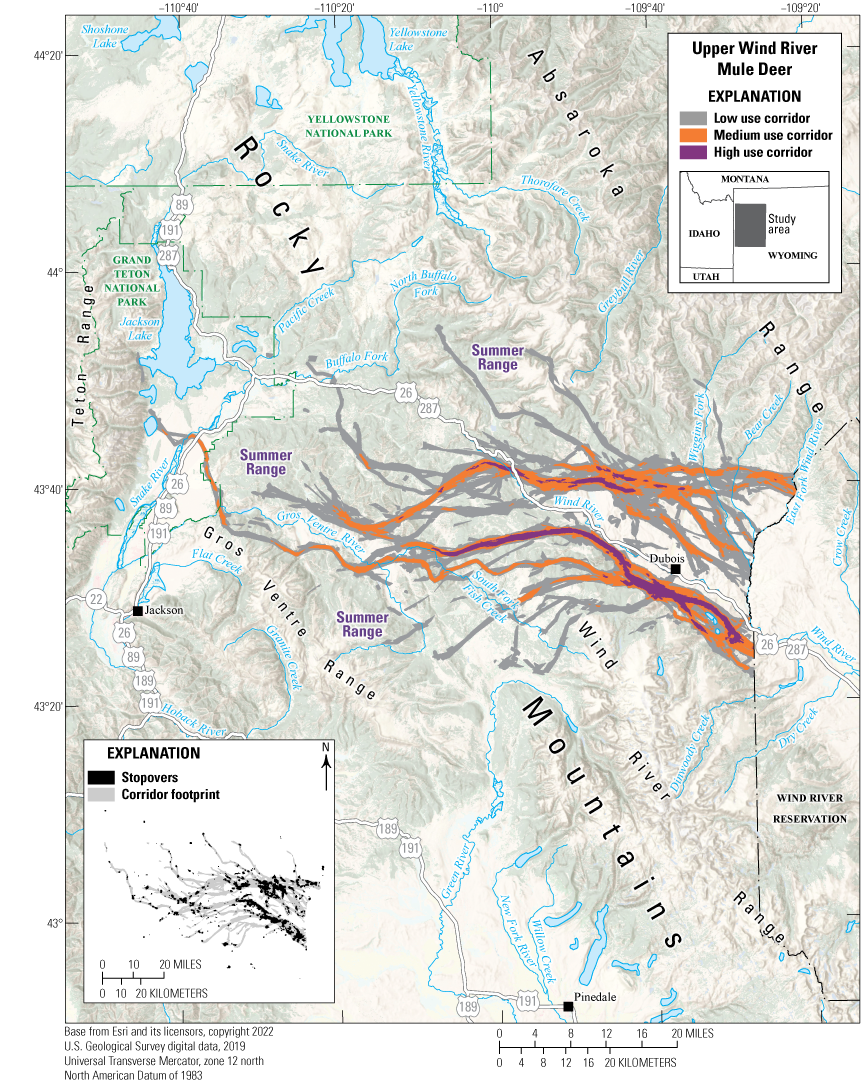
Map showing Wyoming Game and Fish Department’s identified migration corridor of the Upper Wind River mule deer. The identified corridor ends at the reservation boundary to respect the sovereignty of the Eastern Shoshone Tribe of the Wind River Reservation, Wyoming, and Northern Arapaho Tribe of the Wind River Reservation, Wyoming.
Animal Capture and Data Collection
Sample size: 147 adult mule deer
Relocation frequency: Approximately 2 hours
Project duration: 2014–23
Data Analysis
Corridor analysis: Line buffer method using 984 ft (300 m) buffer (Merkle and others, 2023)
Stopover analysis: Brownian bridge movement models (Sawyer and others, 2009)
Delineation of migration periods: Net Squared Displacement (Bunnefeld and others, 2011; app. 1)
Models derived from:
Migration use classifications:Corridor and Stopover Summary
Migration start and end dates (median):
Number of days migrating (mean): Migration corridor length: Migration corridor area:Other Information
Project contacts:
-
• Alyson Courtemanch (alyson.courtemanch@wyo.gov), Wildlife Biologist, Wyoming Game and Fish Department
-
• Sarah Dewey (sarah_dewey@nps.gov), Wildlife Biologist, National Park Service, Grand Teton National Park
-
• Zach Gregory (zach.gregory@wyo.gov), Wildlife Biologist, Wyoming Game and Fish Department
-
• Pat Hnilicka (pat_hnilicka@fws.gov), Wildlife Biologist, U.S. Fish and Wildlife Service
-
• Matthew Kauffman (mkauffm1@uwyo.edu), U.S. Geological Survey, Wyoming Cooperative Fish and Wildlife Research Unit, Department of Zoology and Physiology, University of Wyoming
-
• Art Lawson (lawson@windriverfishandgame.com), Director, Shoshone & Arapaho Tribes Fish & Game
-
• Daryl Lutz (daryl.lutz@wyo.gov), Wildlife Management Coordinator, Wyoming Game and Fish Department
-
• Cheyenne Stewart (cheyenne.stewart@wyo.gov), Wildlife Management Coordinator, Wyoming Game and Fish Department
-
• Blake Lowrey (blowrey@usgs.gov), Research Ecologist, U.S. Geological Survey Northern Rocky Mountain Science Center
-
• Wyoming Game and Fish Department, 2024, Wyoming Game and Fish Department migration corridor threat evaluation worksheet—Upper Wind River mule deer: Cheyenne, Wyo., Wyoming Game and Fish Department, 8 p. [Also available at https://wgfd.wyo.gov/sites/default/files/2024-06/ThreatEvaluation_UpperWindRiverMD_FinalDraft.pdf.]
Idaho | Pronghorn
White Clouds Pronghorn
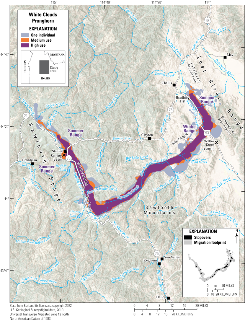
The White Clouds pronghorn herd winter range runs from Willow Creek Summit to Bradbury Flat and extends to the south to Spar Canyon. Pronghorn concentrate on both sides of U.S. Highway 93 between Willow Creek Summit and Bradbury Flat in winter (fig. 18). This area is mostly public land (BLM) with some private properties along U.S. Highways 93 and 75. The winter range comprises broad, flat sagebrush-steppe at lower elevations and rolling, sagebrush-covered hills from Bradbury Flat to Road Creek. Snow accumulation is light during most winters with occasional short periods of deeper snow, generally later in winter (late January–February). Pronghorn concentrations vary depending on snow depth and winter severity. White Clouds pronghorn have two main migration styles. Most pronghorn wintering here migrate to the west along a narrow corridor following the East Fork Salmon River, Germania Creek, and Pole Creek to the Sawtooth Valley south of Stanley, Idaho. Once in the Stanley Basin, an unknown number of individuals stay south of Stanley, whereas others continue northwest into Valley Creek and upper Marsh Creek. This migration is likely the highest elevation pronghorn migration in North America (8,480 ft [2,585 m]). The summer range in the Sawtooth Valley, Valley Creek, and Marsh Creek receives abundant precipitation and comprises meadows and sagebrush-steppe with high-quality forage. The other, much shorter, migration routes are either limited elevational migrations to the northeast to the Lost River Range or to the southwest to the Road and Herd Creeks area. Barriers to this migration include wildlife-unfriendly fencing along the route and a long stretch of heavily forested habitat that pronghorn pass through, which increases the risk of predation by mountain lions, black bears, Canis lupus (gray wolves), and Canis latrans (coyotes). The White Clouds pronghorn herd faces unique challenges throughout the year. On summer range, increased development in the Sawtooth Valley and a concurrent increase in fences impede movements and access to forage; on the eastern part of the migration route, an increase in nonnative annual grasses (Bromus tectorum [cheatgrass]) reduces forage quality; and on winter range, an increasing feral horse population competes for forage and water resources.
Map showing migration routes and stopovers of the White Clouds pronghorn herd.
Animal Capture and Data Collection
Sample size: 13 adult female pronghorn
Relocation frequency: 4 hours
Project duration: 2020–24
Data Analysis
Migration route and stopover analysis: Brownian bridge movement models (Sawyer and others, 2009) with an 8-hour time lag
Delineation of migration periods: Net Squared Displacement (Bunnefeld and others, 2011)
Models derived from:
Migration use classifications:Migration route and Stopover Summary
Migration start and end dates (median):
Number of days migrating (mean): Migration route length: Migration route area:Other Information
Idaho migration routes are updated and viewable by Idaho Department of Fish and Game (Idaho Department of Fish and Game, 2024). Mapping layers shown for this herd are sensitive but may be made available to researchers upon request by contacting Idaho Department of Fish and Game (idfgdatarequests@idfg.idaho.gov).
Project contacts:
-
• Matt Mumma (matt.mumma@idfg.idaho.gov), Wildlife Research Manager, Idaho Department of Fish and Game
-
• Jacob Gray (jacob.gray@idfg.idaho.gov), Natural Resources Program Coordinator Habitat and Migration, Idaho Department of Fish and Game
-
• Dennis Newman (dennis.newman@idfg.idaho.gov), Regional Wildlife Manager, Idaho Department of Fish and Game
-
• Bret Stansberry (bret.stansberry@idfg.idaho.gov), Wildlife Regional Biologist, Idaho Department of Fish and Game
-
• Regan Tempe (tempe.regan@idfg.idaho.gov), Regional Wildlife Biologist, Idaho Department of Fish and Game
Nevada | Pronghorn
Central Washoe Pronghorn
Central Washoe pronghorn use a network of interconnected migration corridors and seasonal ranges (fig. 19). Pronghorn summering east of Long Valley migrate south to winter ranges on Mahogany Mountain and the Calico Hills, where they overlap with pronghorn that summer near The Buttes. Pronghorn summering by Cherry Mountain also use Mahogany Mountain and areas near Nevada Route 447 during winter; some pronghorn travel long distances to use both locations during the same season. One pronghorn dispersed from the Calico Hills to Melody Mountain in early 2020, overlapping with other wintering pronghorn that summer near Granite Range and Hog Ranch Mountain. Pronghorn wintering by Boulder Flat have summer ranges to the southwest of Long Valley and near Surprise Valley, California. Other pronghorn wintering north of Nevada Route 447 migrate south to summer near the Cottonwood Mountains in California, temporarily overlapping with pronghorn that winter near the Smoke Creek Desert, and use additional summer ranges surrounding Painters Flat, California. Habitat primarily consists of shrub-steppe intermixed with grassland. Big sagebrush and basin big sagebrush dominate low altitudes, transitioning to Wyoming big sagebrush, followed by A. arbuscula (low sagebrush) and mountain big sagebrush as elevation increases.
Challenges to this herd include invasive annual grasses and Juniperus occidentalis (western juniper) encroachment, potential competition with feral horses, unpermitted livestock grazing on some BLM allotments, and livestock fences that inhibit efficient movement. Several habitat improvement projects have been implemented in Central Washoe County, Nevada. The Horse Canyon Spring protection project installed pipe-rail fencing to protect more than 8.75 acres (3.54 ha) of degraded springs and the Cherry Spring protection project preserved 20 acres (8.09 ha) of riparian habitat along a prominent pronghorn migration route on private land (NDOW, 2024). Additionally, the NDOW cooperated with the Winnemucca BLM Field Office to treat approximately 7,755 acres (3,138 ha) of burned native rangeland from the 2020 Poodle fire using an aerial herbicide application to reduce annual grass invasion and promote native vegetation growth.
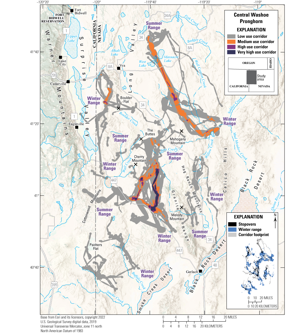
Map showing migration corridors, stopovers, and winter ranges of the Central Washoe pronghorn herd.
Animal Capture and Data Collection
Sample size: 42 adult female pronghorn
Relocation frequency: Approximately 2−17 hours
Project duration: 2019–present (data through September 2023 analyzed for this report)
Data Analysis
Corridor, stopover, and winter range analysis: Brownian bridge movement models (Sawyer and others, 2009); corridor analysis used Fixed Motion Variance (11,840 ft2 [1,100 m2]; McKee and others, 2024) with a 48-hour time lag (app. 1)
Delineation of migration periods: Net Squared Displacement (Bunnefeld and others, 2011)
Models derived from:
Migration use classifications:Corridor and Stopover Summary
Migration start and end dates (median):
Number of days migrating (mean): Migration corridor length: Migration corridor area:Other Information
Project contacts:
-
• Don Whittaker (don.whittaker@odfw.oregon.gov), Ungulate Management Coordinator, Oregon Department of Fish and Wildlife
-
• Cody McKee (cmckee@ndow.org), Wildlife Staff Specialist, Nevada Department of Wildlife
-
• Cody Schroeder (cschroeder@ndow.org), Wildlife Staff Specialist, Nevada Department of Wildlife
-
• Collins, G.H., 2016, Seasonal distribution and routes of pronghorn in the northern Great Basin: Western North American Naturalist, v. 76, no. 1, p. 101–112. [Also available at https://scholarsarchive.byu.edu/wnan/vol76/iss1/10.]
Oregon | Pronghorn
Paulina Pronghorn
Most of the Paulina pronghorn herd winter either near U.S. Highway 20 or Browns Valley; additional winter ranges are near Christmas Lake Valley and Alfalfa, Oregon (fig. 20). During spring, pronghorn use a complex network of migration corridors to reach summer ranges near West Butte, Mahogany Butte, Trail Butte, Bronco Butte, Stookey Flat, and the base of the Maury Mountains. The seasonal ranges of different pronghorn frequently overlapped, often with the same area used as either summer or winter range, depending on the individual. One pronghorn dispersed north almost 60 mi (97 km) to new seasonal ranges near Waterman Flat during the spring of 2018, crossing the Ochoco Mountains and U.S. Highway 26. In 2019, another pronghorn traveled south from winter range in Browns Valley until finally turning back at Oregon Route 140 and crossing U.S. Highway 395 twice in a 76-mi (122-km) round-trip movement.
Summer and winter ranges were dominated by shrubland with common species, including low sagebrush, big sagebrush, mountain big sagebrush, and Wyoming big sagebrush. Winter ranges contained more farmland and Columbia Basin grassland, and summer ranges contained more western juniper and ponderosa pine. U.S. Highway 20 bisects a major migration corridor and multiple seasonal ranges, which increases the risk of WVCs. One particularly high-use area occurs where the highway separates two fields of Medicago sativa (alfalfa) pivots near Hampton, Oregon. Paulina pronghorn were present in alfalfa pivots throughout the year, and individuals often incorporated the same pivot into summer and winter ranges. Paulina pronghorn occupy an area containing more than 995 mi (1,601 km) of known BLM fencing because of their range's proximity to residential and agricultural regions. On average, the straight-line paths of pronghorn intersected fences almost 148 times per animal per year. However, this value only incorporates mapped BLM fences and ignores instances where pronghorn approached fences but did not attempt to cross, likely underestimating the true effect on pronghorn behavior.
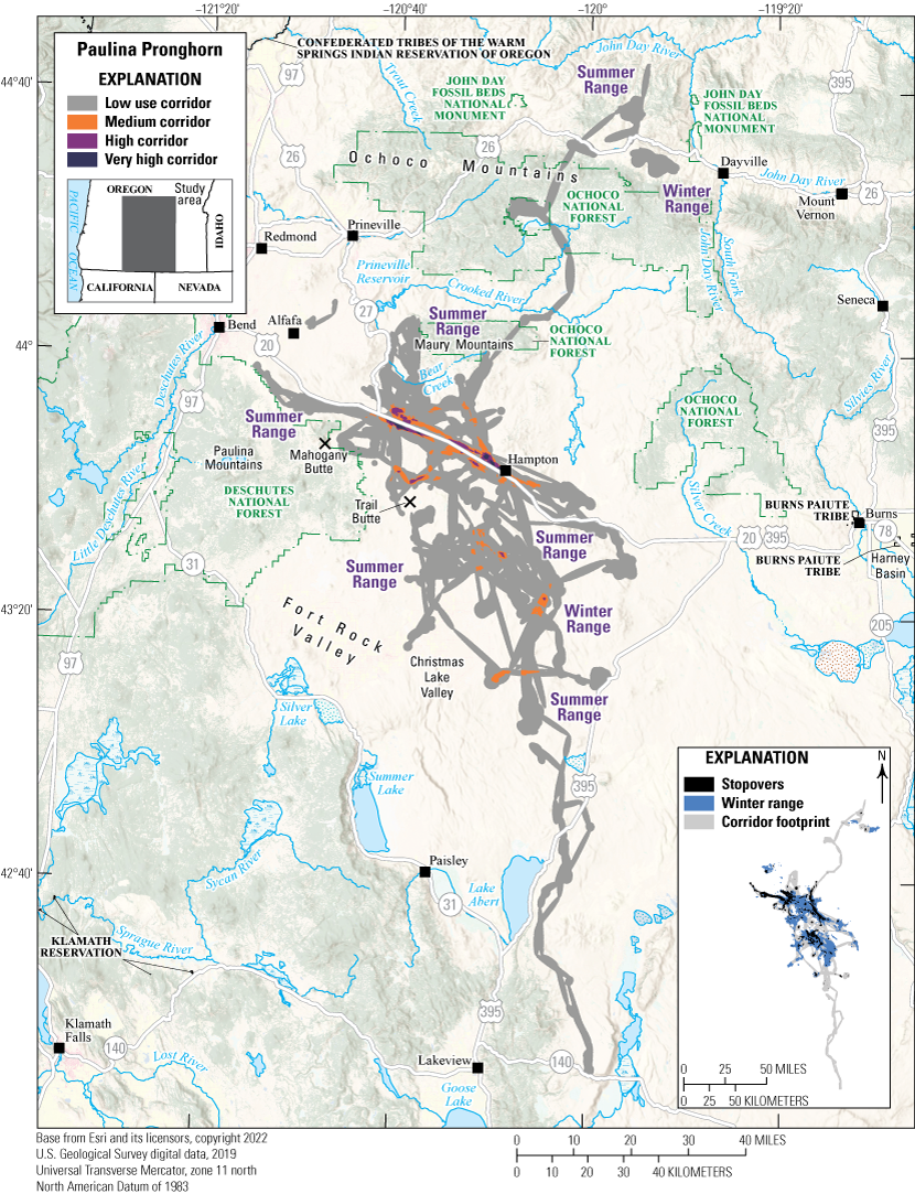
Map showing migration corridors, stopovers, and winter ranges of the Paulina pronghorn herd.
Animal Capture and Data Collection
Sample size: 53 adult female pronghorn
Relocation frequency: Approximately 5−13 hours
Project duration: 2017–23 (data through December 2023 analyzed for this report)
Data Analysis
Corridor, stopover, and winter range analysis: Brownian bridge movement models (Sawyer and others, 2009); corridor analysis used Fixed Motion Variance (11,840 ft2 [1,100 m2]; McKee and others, 2024) with a 48-hour time lag (app. 1)
Delineation of migration periods: Net Squared Displacement (Bunnefeld and others, 2011)
Models derived from:
Migration use classifications:Corridor and Stopover Summary
Migration start and end dates (median):
Number of days migrating (mean): Migration corridor length: Migration corridor area:Other Information
Project contacts:
-
• Don Whittaker (don.whittaker@odfw.oregon.gov), Ungulate Management Coordinator, Oregon Department of Fish and Wildlife
-
• Walch, A.J., Heath, C., Harju, S., and Whittaker, D.G., 2022, Seasonal resource selection by pronghorn in central Oregon, in Western States and Provinces Pronghorn Workshop, 29th, Deadwood, South Dakota, August 22–25, 2022, Proceedings: Western Association of Fish and Wildlife Agencies, p. 51–63. [Also available at https://wafwa.org/wp-content/uploads/2024/04/WAFWA-Pronghorn_Workshop_Proceedings_2022.pdf.]
Oregon and Nevada | Pronghorn
Sheldon-Hart Mountain Pronghorn
Sheldon-Hart Mountain pronghorn traverse northwest Nevada and southeast Oregon (fig. 21). First published in Kauffman and others (2022a), this updated analysis includes 8 years of additional GPS data from 51 pronghorn. Winter ranges are as far north as Catlow Valley, Oregon, and as far south as the Black Rock Desert, Nevada. Winter range use depends on winter conditions, and almost half the Sheldon-Hart Mountain pronghorn travel to additional winter ranges in more severe winters. The highest use midwinter migration corridors occur between Sage Hen Flats and Big Spring Table, and the highest use spring and fall migration corridors occur between Sage Hen Flats and Little Juniper Mountain. Core summer ranges are near Duhaime Flat, Hart Mountain, Little Juniper Mountain, and Catnip Mountain. One pronghorn traveled 86.5 mi (139 km) to a new range during summer in 2016 before returning to its previous location within the same season. This herd is affected by invasive grasses, habitat loss, juniper encroachment, severe droughts, fences, and WVCs along Oregon/Nevada Route 140. Wildfires in summer range, such as the 2019 Poker fire and the 2024 Warner Peak fire, also spread invasive grasses in areas without sufficient shrub cover.
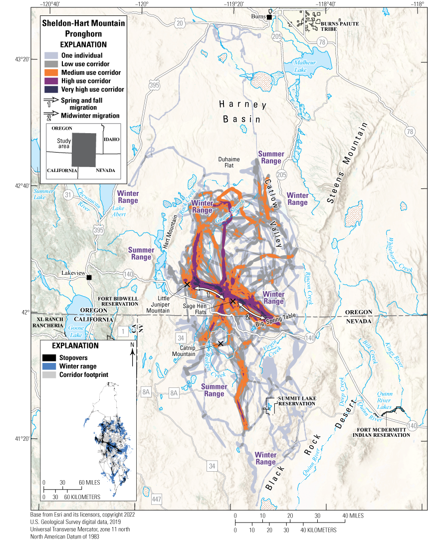
Map showing migration corridors, stopovers, and winter ranges of the Sheldon-Hart Mountain pronghorn herd.
Animal Capture and Data Collection
Sample size: 82 adult female pronghorn
Relocation frequency: Approximately 2−17 hours
Project duration: 2011–13, 2015–17, and 2019–23 (data through September 2023 analyzed for this report)
Data Analysis
Corridor, stopover, and winter range analysis: Brownian bridge movement models (Sawyer and others, 2009); corridor analysis used Fixed Motion Variance (11,840 ft2 [1,100 m2]; McKee and others, 2024) with a 48-hour time lag (app. 1)
Delineation of migration periods: Net Squared Displacement (Bunnefeld and others, 2011)
Models derived from:
Migration use classifications:Corridor and Stopover Summary (Midwinter)
Migration start and end dates (median):
Number of days migrating (mean): Migration corridor length:Corridor and Stopover Summary (Spring and Fall)
Migration start and end dates (median):
Number of days migrating (mean): Migration corridor length: Migration corridor area (combined):Other Information
Project contacts:
-
• Don Whittaker (don.whittaker@odfw.oregon.gov), Ungulate Management Coordinator, Oregon Department of Fish and Wildlife
-
• Cody McKee (cmckee@ndow.org), Wildlife Staff Specialist, Nevada Department of Wildlife
-
• Cody Schroeder (cschroeder@ndow.org), Wildlife Staff Specialist, Nevada Department of Wildlife
-
• Collins, G.H., 2016, Seasonal distribution and routes of pronghorn in the northern Great Basin: Western North American Naturalist, v. 76, no. 1, p. 101–112. [Also available at https://scholarsarchive.byu.edu/wnan/vol76/iss1/10.]
-
• Larkins, A., Harju, S., and Whittaker, D.G., 2019, Pronghorn migration and survival—A statistical analysis of a southeastern Oregon population, in Wakeling, B.F., and Schroeder, C., eds., Learning from the past—Adapting for the future, v. 28 of Western United States and Provinces Biennial Pronghorn Workshop, 28th, Reno, Nev., 2018, [Proceedings]: Western Association of Fish and Wildlife Agencies, p. 19–28. [Also available at https://wafwa.org/wp-content/uploads/2020/09/Pronghorn-Proceedings-Final-2019.pdf.]
Oregon, Nevada, and California | Pronghorn
Surprise Valley Pronghorn
The Surprise Valley pronghorn herd crosses Oregon, Nevada, and California, primarily occupying shrub-steppe communities containing low sagebrush, big sagebrush, and mountain big sagebrush with mixed-conifer forests at some higher elevations. Most pronghorn use winter ranges near Lake Abert and Warner Valley in Oregon and the northeast edge of Surprise Valley in California (fig. 22). Individual seasonal ranges often extend over large areas; some pronghorn travel along Surprise Valley or move between Surprise Valley and Warner Valley during the winter. Summer ranges are near Oregon Route 140, Coleman Valley, Sage Hen Butte, the northwestern rim of Long Valley, and Fort Bidwell, California. In comparison to winter ranges, summer ranges include more mountain big sagebrush and wetland habitats. Summer ranges in higher elevations also contain sections of encroaching western juniper and several low-elevation seasonal ranges around Surprise Valley and Coleman Valley that overlap agricultural areas. Multiple pronghorn migrate across, or have summer ranges adjacent to, Oregon Route 140, which increases the risk of WVCs.
In Oregon, the Surprise Valley herd inhabits the Warner WMU, which has benefited from multiple habitat mitigation projects. Since 2010, more than 49,940 acres (20,210 ha) of western juniper were removed, 13,568 acres (5,491 ha) were treated to eliminate invasive plants, 13,002 acres (5,262 ha) of prescribed burns were completed, and 1,702 acres (689 ha) were reseeded with shrubs and grasses (Oregon Department of Fish and Wildlife, 2015, 202034). In 2023, the NDOW cooperated with the BLM Applegate Field Office to complete a 5.7-mi (9.2-km) fence improvement project that benefitted pronghorn migrating across the Nevada and California State boundary fence near Big Mud Lake and Fee Reservoir (NDOW, 2024). The transboundary nature of this herd will potentially require cooperation among Oregon, Nevada, and California State agencies and stakeholders to ensure migration corridors are unimpeded and seasonal ranges are protected.
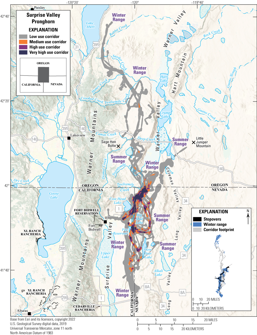
Map showing migration corridors, stopovers, and winter ranges of the Surprise Valley pronghorn herd.
Animal Capture and Data Collection
Sample size: 27 adult female pronghorn
Relocation frequency: Approximately 2−13 hours
Project duration: 2015–17 and 2019–23 (data through September 2023 analyzed for this report)
Data Analysis
Corridor, stopover, and winter range analysis: Brownian bridge movement models (Sawyer and others, 2009); corridor analysis used Fixed Motion Variance (11,840 ft2 [1,100 m2]; McKee and others, 2024) with a 48-hour time lag (app. 1)
Delineation of migration periods: Net Squared Displacement (Bunnefeld and others, 2011)
Models derived from:
Migration use classifications:Corridor and Stopover Summary
Migration start and end dates (median):
Number of days migrating (mean): Migration corridor length: Migration corridor area:Other Information
Project contacts:
-
• Don Whittaker (don.whittaker@odfw.oregon.gov), Ungulate Management Coordinator, Oregon Department of Fish and Wildlife
-
• Cody McKee (cmckee@ndow.org), Wildlife Staff Specialist, Nevada Department of Wildlife
-
• Cody Schroeder (cschroeder@ndow.org), Wildlife Staff Specialist, Nevada Department of Wildlife
-
• Collins, G.H., 2016, Seasonal distribution and routes of pronghorn in the northern Great Basin: Western North American Naturalist, v. 76, no. 1, p. 101–112. [Also available at https://scholarsarchive.byu.edu/wnan/vol76/iss1/10.]
Wyoming | Pronghorn
Gillette Pronghorn
The Gillette pronghorn herd comprises the North Black Hills and Gillette Herd Units that are separated by State Route 59. In general, pronghorn populations in northeastern Wyoming are understudied, and this work represents the first GPS study to document detailed movement and distribution patterns of pronghorn in this region. This initial study of 35 pronghorn revealed clear interstate movements and migrations of 30–50 mi (48–80 km) between Wyoming and Montana, including occasional facultative winter migrations of Montana pronghorn into Wyoming, and more consistent seasonal migrations of Wyoming pronghorn to summer ranges in Montana. Regardless of the migratory type or State origin, all pronghorn migrations paralleled the Little Powder River, and the heaviest use was on the river’s east side (fig. 23). Pronghorn movements to the south were limited by Interstate 90 in Wyoming and blocked to the north by U.S. Highway 212 in Montana. East and west movements across the Little Powder River and State Route 59 were rare and only documented at the southern extent of the migrations. The region largely comprises private lands interspersed with parcels managed by the BLM. Roadways, fencing, energy development, invasive species, and disease are the primary management concerns for pronghorn herds in this region. This project was initiated by the WGFD, and all animals were captured on winter ranges in Wyoming. Although many of the animals moved north into Montana, Montana Fish, Wildlife & Parks was not directly involved in the project or the resulting maps produced in this report.
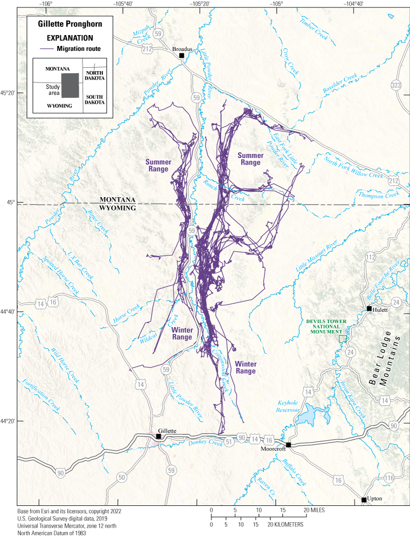
Map showing migration routes of the Gillette pronghorn herd.
Animal Capture and Data Collection
Sample size: 35 adult female pronghorn
Relocation frequency: Approximately 2 hours
Project duration: 2022–24
Data Analysis
Delineation of migration periods: Net Squared Displacement (Bunnefeld and others, 2011; app. 1)
Models derived from:
Corridor and Stopover Summary
Migration start and end dates (median):
Number of days migrating (mean): Migration corridor length:Wyoming | Pronghorn
Sublette Pronghorn
The Sublette pronghorn herd was originally included in the second volume of the report series (Kauffman and others, 2022a) and is one of the largest pronghorn populations in North America. The management population objective for this herd is 48,000 individuals (WGFD, 2023). During the early 2000s, modeled population size—estimated using aerial line-transect abundance surveys—fluctuated between 31,000 and 62,000 pronghorn. The 5-year average herd size was estimated at 33,700 individuals in 2024, although the herd’s posthunting season population size in 2024 was 26,800 individuals (WGFD, 2024).
Sublette pronghorn winter in the more southern areas of the upper Green River Basin in Wyoming (fig. 24). Depending on winter severity, individual pronghorn winter between Pinedale, Wyoming, in the north, to Rock Springs, Wyoming, in the south, and on the west side of the Red Desert. Winter ranges include a mix of grassland, desert shrub, sagebrush-dominated mesas, and rolling hills. The herd uses a variety of summer ranges, which generally consist of higher-elevation grasslands and sagebrush habitats intermixed with mesic meadows.
Sublette pronghorn have mixed movement strategies: 75 percent of pronghorn tracked with GPS collars (469 females) show migratory behavior with distinct seasonal ranges, and the remaining 25 percent show more nomadic or resident strategies. Sublette pronghorn migrate an average one-way distance of nearly 42 miles (68 km), and some individuals migrate more than 150 miles (241 km). This herd includes some of the longest-distance migrating pronghorn; one pronghorn migrated 200 mi (322 km) from the southern reaches of the range to Grand Teton National Park following Bridger-Teton National Forest Path of the Pronghorn, the first federally designated migration corridor (Berger and Cain, 2014). Others migrate to summer ranges in the Hoback River valley, the Gros Ventre Range, and along the east slope of the Wyoming Range and west slope of the Wind River Range.
Many pronghorn within this herd migrate or winter near energy development, mainly oil and gas development in the Pinedale Anticline, Jonah, and Calpet natural gas fields. Previous research shows pronghorn spend less time in areas after development (Sawyer and others, 2025), and sometimes, pronghorn abandon traditional winter ranges altogether (Reinking and others, 2019). Additional gas wells are permitted in the Normally Pressured Lance field in the center of the Sublette pronghorn herd range, and pressures are increasing from renewable energy sources, such as wind and solar developments along the Interstate 80 corridor in the southern reaches of the herd’s range. However, in 2012–13, Sublette pronghorn benefitted from wildlife overpasses constructed over U.S. Highway 191 at the Trapper’s Point and Boroff Hill sites in high-use parts of the migration route, and an arch crossing structure was constructed to facilitate pronghorn movement across U.S. Highway 189 to the south of Big Piney, Wyoming. In 2024, the Wyoming Game and Fish Department identified the migration corridor as part of Governor Gordon’s Migration Corridor Executive Order 2020–1 (State of Wyoming, 2020), and the process of designating the corridor is currently (2025) ongoing.
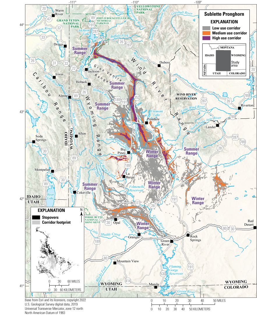
Map showing migration corridors and stopovers of the Sublette Pronghorn herd.
Animal Capture and Data Collection
Sample size: 469 adult female pronghorn
Relocation frequency: Approximately 2−5 hours
Project duration: 2002–25
Data Analysis
Corridor analysis: Line buffer method using 300 m buffer (Merkle and others, 2023)
Stopover analysis: Brownian bridge movement models (Sawyer and others, 2009) with a 5 percent volume contour.
Delineation of migration periods: Net Squared Displacement (Bunnefeld and others, 2011; app. 1)
Models derived from:
Migration use classifications:Corridor and Stopover Summary
Migration start and end dates (median):
Number of days migrating (mean): Migration corridor length: Migration corridor area:Other Information
Project contacts:
-
• Brandon Scurlock (brandon.scurlock@wyo.gov), Wildlife Coordinator, Wyoming Game and Fish Department
-
• Hall Sawyer (hsawyer@west-inc.com), Research Biologist, Western EcoSystems Technology, Inc.
-
• Jon Beckmann (jon.beckmann@ks.gov), Wildlife Division Assistant Director-Research, Kansas Department of Wildlife and Parks
-
• Joel Berger (jberger@wcs.org), Senior Scientist, Wildlife Conservation Society
-
• Jeffrey L. Beck (jlbeck@uwyo.edu), Professor, Department of Ecosystem Science and Management, College of Agriculture, Life Sciences and Natural Resources, University of Wyoming
-
• Matthew Kauffman (mkauffm1@uwyo.edu), U.S. Geological Survey, Wyoming Cooperative Fish and Wildlife Research Unit, University of Wyoming
-
• Sarah Dewey (sarah_dewey@nps.gov), Wildlife Biologist, Grand Teton National Park
-
• Beckmann, J.P., Murray, K., Seidler, R.G., and Berger, J., 2012, Human-mediated shifts in animal habitat use—Sequential changes in pronghorn use of a natural gas field in Greater Yellowstone: Biological Conservation, v. 147, no. 1, p. 222–233. [Also available at https://doi.org/10.1016/j.biocon.2012.01.003.]
-
• Reinking, A.K., Smith, K.T., Mong, T.W., Read, M.J., and Beck, J.L., 2019, Across scales, pronghorn select sagebrush, avoid fences, and show negative responses to anthropogenic features in winter: Ecosphere, v. 10, no. 5, art. e02722, 17 p. [Also available at https://doi.org/10.1002/ecs2.2722.]
-
• Reinking, A.K., Smith, K.T., Monteith, K.L., Mong, T.W., Read, M.J., and Beck, J.L., 2018, Intrinsic, environmental, and anthropogenic factors related to pronghorn summer mortality: The Journal of Wildlife Management, v. 82, no. 3, p. 608–617. [Also available at https://doi.org/10.1002/jwmg.21414.]
-
• Sawyer, H., Beckmann, J.P., Seidler, R.G., and Berger, J., 2019, Long‐term effects of energy development on winter distribution and residency of pronghorn in the Greater Yellowstone Ecosystem: Conservation Science and Practice, v. 1, no. 9, 11 p. [Also available at https://doi.org/10.1111/csp2.83.]
-
• Sawyer, H., Lindzey, F., and McWhirter, D., 2005, Mule deer and pronghorn migration in western Wyoming: Wildlife Society Bulletin, v. 33, no. 4, p. 1266–1273. [Also available at https://doi.org/10.2193/0091-7648(2005)33[1266:MDAPMI]2.0.CO;2.]
-
• Wyoming Game and Fish Department [WGFD], 2024, Wyoming Game and Fish Department migration corridor threat evaluation—Sublette pronghorn: Laramie, Wyo., Wyoming Game and Fish Department, 17 p. [Also available at https://wgfd.wyo.gov/sites/default/files/2024-04/ThreatEvaluation_SublettePronghorn_FINAL.pdf.]
Colorado | Elk
San Juan Basin Elk
The San Juan Basin elk herd (DAU E31) is in the southwest corner of Colorado (fig. 25). The DAU is 2,800 mi2 (7252 km2) and is bound to the north and east by the Continental Divide, to the south by the New Mexico border, and to the west by the Animas River. Elevations range from 5,000 ft (1,524 m) to more than 14,000 ft (4,267 m). The DAU encompasses Durango, Bayfield, Ignacio, and Pagosa Springs, Colorado, and landownership is a mix of 30 percent private, 12 percent Southern Ute Indian Tribe, 2 percent BLM, and 56 percent FS. Elk generally summer at higher elevations at the northern and eastern part of the DAU and regularly cross the Continental Divide. Elk winter at lower elevations in the southern part of the DAU and into Southern Ute Indian Tribal lands and New Mexico.
Public lands attract multitudes of outdoor recreationists to southwest Colorado, which causes urban, exurban, and recreational development to occur on a large part of critical elk habitat. Development affects the entire DAU, but it is a considerably larger problem near Durango, Bayfield, and Pagosa Springs, Colorado. In addition, one of the largest natural gas fields in the United States overlaps part of the winter range. Several highways, including U.S. Highways 160, 84, and 550, and Colorado State Highways 172 and 151, bisect elk habitat. These roadways affect migrating elk and elk on winter range and increase WVCs. The Southern Ute Indian Tribe and CPW have used GPS-collared data from elk to identify priority habitat, migration routes, timing of migrations, and highway crossing locations. These data and WVC data are used to identify locations for building wildlife-crossing structures.
In 2022, CDOT, the Southern Ute Indian Tribe, CPW, and other partners helped to fund the construction of a wildlife overpass and underpass on a 1.9-mi (3.1-km) section of U.S. Highway 160 near Chimney Rock and the intersection of Colorado State Highway 151. These structures connected an important area of winter range containing high concentrations of elk and mule deer to summer habitats to the north. A multiyear monitoring study was started in 2023 (refer to the “San Juan Basin Mule Deer” section in this report) to determine the effectiveness of the project to reduce WVCs and maintain wildlife movement permeability. Preliminary data analysis (from data collected in October 2023 through June 2024) revealed that the underpass and overpass provide for safe crossings and habitat connectivity for elk and many other wildlife species and increase safer traveling for residents and visitors using the highway (Cramer, 2024).
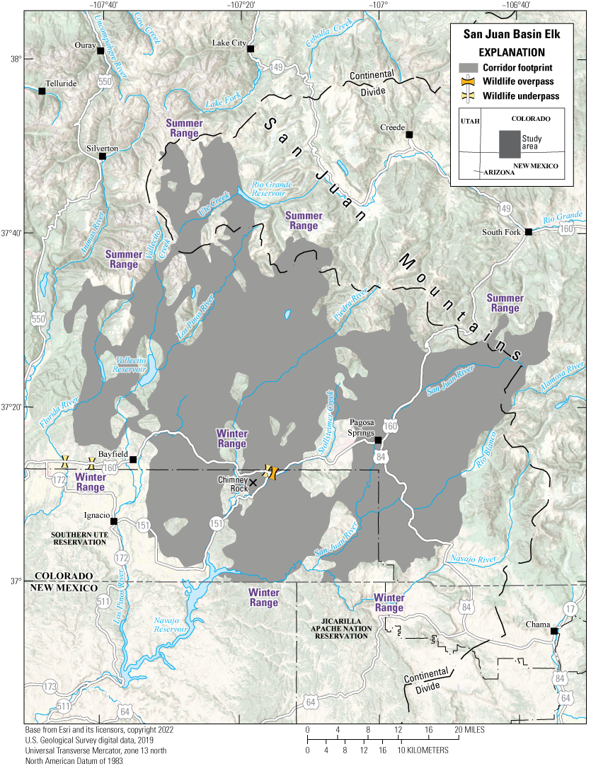
Migration footprint used by two or more individuals in the San Juan Basin elk herd.
Animal Capture and Data Collection
Sample size: 117 adult female elk
Relocation frequency: Approximately 2–3 hours
Project duration: 2013–22
Data Analysis
Corridor footprint analysis: Brownian bridge movement models (Sawyer and others, 2009)
Delineation of migration periods: Net Squared Displacement (Bunnefeld and others, 2011)
Models derived from:
Migration use classifications:Corridor and Stopover Summary
Migration start and end dates (median):
Number of days migrating (mean): Migration corridor length: Migration corridor area:Other Information
Project contacts:
-
• Brad Weinmeister (brad.weinmeister@state.co.us), Terrestrial Biologist, Colorado Parks and Wildlife
-
• Aran Johnson (ajohnson@southernute-nsn.gov), Wildlife Division Head, Southern Ute Indian Tribe
-
• Michelle Cowardin (michelle.cowardin@state.co.us), Wildlife Movement Coordinator, Colorado Parks and Wildlife
References Cited
Berger, J., and Cain, S.L., 2014, Moving beyond science to protect a mammalian migration corridor: Conservation Biology, v. 28, no. 5, p.1142–1150. [Also available at https://doi.org/10.1111/cobi.12327.]
Bunnefeld, N., Börger, L., van Moorter, B., Rolandsen, C.M., Dettki, H., Solberg, E.J., and Ericsson, G., 2011, A model‐driven approach to quantify migration patterns—Individual, regional and yearly differences: Journal of Animal Ecology, v. 80, no. 2, p. 466–476. [Also available at https://doi.org/10.1111/j.1365-2656.2010.01776.x.]
Calabrese, J.M., Fleming, C.H., and Gurarie, E., 2016, ctmm—An R package for analyzing animal relocation data as a continuous‐time stochastic process: Methods in Ecology and Evolution, v. 7, no. 9, p, 1124–1132. [Also available at https://doi.org/10.1111/2041-210X.12559.]
Craighead, F.C., Jr., Craighead, J.J., Cote, C.E., and Buechner, H.K., 1972, Satellite and ground radiotracking of elk: National Aeronautics and Space Administration, p. 99–111. [Conference paper acquired by the National Aeronautics Space Administration on August 6, 2013. Also available at https://ntrs.nasa.gov/citations/19720017418.]
Colorado Parks and Wildlife [CPW], 2023, Final northwest Colorado mule deer herd management plans: Grand Junction, Colo., Colorado Parks and Wildlife, 320 p. [Also available at https://cpw.widencollective.com/assets/share/asset/z1sjsg2w3w.]
Cramer, P., 2024, Colorado Department of Transportation research study progress report—US 160/SH151 wildlife mitigation research project—study number R122.01, purchase order number 411036588: Denver, Colo., Colorado Department of Transportation, 14 p. [Also available at https://static1.squarespace.com/static/60baf2ed8791194056e335f8/t/67211c77b3d8b57c823359ed/1730223228687/Q2+2024+US+160+Chimney+Rock+Research+FINAL_20 240917.pdf.]
Davies, K.W., and Boyd, C.S., 2019, Ecological effects of free-roaming horses in North American rangelands: Bioscience, v. 69, no. 7, p. 558–565. [Also available at https://doi.org/10.1093/biosci/biz060.]
Dickson, B.G., Albano, C.M., Anantharaman, R., Beier, P., Fargione, J., Graves, T.A., Gray, M.E., Hall, K.R., Lawler, J.J., Leonard, P.B., Littlefield, C.E., McClure, M.L., Novembre, J., Schloss, C.A., Schumaker, N.H., Shah, V.B., and Theobald, D.M., 2019, Circuit‐theory applications to connectivity science and conservation: Conservation Biology, v. 33, no. 2, p. 239–249. [Also available at https://doi.org/10.1111/cobi.13230.]
Fryxell, J.M., and Sinclair, A.R.E., 1988, Causes and consequences of migration by large herbivores: Trends in Ecology & Evolution, v. 3, no. 9, p. 237–241. [Also available at https://doi.org/10.1016/0169-5347(88)90166-8.]
Horne, J.S., Garton, E.O., Krone, S.M., and Lewis, J.S., 2007, Analyzing animal movements using Brownian bridges: Ecology, v. 88, no. 9, p. 2354–2363. [Also available at https://doi.org/10.1890/06-0957.1.
Idaho Department of Fish and Game, 2024, Idaho Department of Fish and Game [documents]: Idaho Department of Fish and Game web page, accessed April 18, 2024, at https://data-idfggis.opendata.arcgis.com/search?collection=document.
Kauffman, M.J., Copeland, H.E, Berg, J., Bergen, S., Cole, E., Cuzzocreo, M., Dewey, S., Fattebert, J., Gagnon, J., Gelzer, E., Geremia, C., Graves, T., Hersey, K., Hurley, M., Kaiser, R., Meacham, J., Merkle, J., Middleton, A., Nuñez, T., Oates, B., Olson, D., Olson, L., Sawyer, H., Schroeder, C., Sprague, S., Steingisser, A., and Thonhoff, M., 2020a, Ungulate migrations of the Western United States, volume 1 (ver. 1.1, December 2023): U.S. Geological Survey Scientific Investigations Report 2020–5101, 119 p. [Also available at https://doi.org/10.3133/sir20205101.]
Kauffman, M.J., Copeland, H.E., Cole, E., Cuzzocreo, M., Dewey, S., Fattebert, J., Gagnon, J., Gelzer, E., Graves, T.A., Hersey, K., Kaiser, R., Meacham, J., Merkle, J., Middleton, A., Nuñez, T., Oates, B., Olson, D., Olson, L., Sawyer, H., Schroeder, C., Sprague, S., Steingisser, A., and Thonhoff, M., 2020b, Ungulate migrations of the Western United States, volume 1: U.S. Geological Survey data release, https://doi.org/10.5066/P9O2YM6I.
Kauffman, M.J., Aikens, E.O., Esmaeili, S., Kaczensky, P., Middleton, A., Monteith, K.L., Morrison, T.A., Mueller, T., Sawyer, H., and Goheen, J.R., 2021, Causes, consequences, and conservation of ungulate migration: Annual Review of Ecology, Evolution, and Systematics, v. 52, no. 1, p. 453–478. [Also available at https://doi.org/10.1146/annurev-ecolsys-012021-011516.]
Kauffman, M.J., Lowrey, B., Beck, J., Berg, J., Bergen, S., Berger, J., Cain, J., III, Dewey, S., Diamond, J., Duvuvuei, O., Fattebert, J., Gagnon, J., Garcia, J., Greenspan, E., Hall, E., Harper, G., Harter, S., Hersey, K., Hnilicka, P., Hurley, M., Knox, L., Lawson, A., Maichak, E., Meacham, J., Merkle, J., Middleton, A., Olson, D., Olson, L., Reddell, C., Robb, B., Rozman, G., Sawyer, H., Schroeder, C., Scurlock, B., Short, J., Sprague, S., Steingisser, A., and Tatman, N., 2022a, Ungulate migrations of the Western United States, volume 2: U.S. Geological Survey Scientific Investigations Report 2022–5008, 160 p. [Also available at https://doi.org/10.3133/sir20225008.]
Kauffman, M.J., Lowrey, B., Beck, J., Berg, J., Bergen, S., Berger, J., Cain, J., Dewey, S., Diamond, J., Duvuvuei, O., Fattebert, J., Gagnon, J., Garcia, J., Greenspan, E., Hall, E., Harper, G., Harter, S., Hersey, K., Hnilicka, P., Hurley, M., Knox, L., Lawson, A., Maichak, E., Meacham, J., Merkle, J., Middleton, A., Olson, D., Olson, L., Reddell, C., Robb, B., Rozman, G., Sawyer, H., Schroeder, C., Scurlock, B., Short, J., Sprague, S., Steingisser, A., and Tatman, N., 2022b, Ungulate migrations of the Western United States, volume 2: U.S. Geological Survey data release, https://doi.org/10.5066/P9TKA3L8.
Kauffman, M.J., Lowrey, B., Berg, J., Bergen, S., Brimeyer, D., Burke, P., Cufaude, T., Cain, J.W., III, Cole, J., Courtemanch, A., Cowardin, M., Cunningham, J., DeVivo, M., Diamond, J., Duvuvuei, O., Fattebert, J., Ennis, J., Finley, D., Fort, J., Fralick, G., Freeman, E., Gagnon, J., Garcia, J., Gelzer, E., Graham, M., Gray, J., Greenspan, E., Hall, L.E., Hendricks, C., Holland, A., Holms, B., Huggler, K., Hurley, M.A., Jeffreys, E., Johnson, A., Knox, L., Krasnow, K., Lockyer, Z., Manninen, H., McDonald, M., McKee, J.L., Meacham, J., Merkle, J., Moore, B., Mong, T.W., Nielsen, C., Oates, B., Olson, K., Olson, D., Olson, L., Pieron, M., Powell, J., Prince, A., Proffitt, K., Reddell, C., Riginos, C., Ritson, R., Robatcek, S., Roberts, S., Sawyer, H., Schroeder, C., Shapiro, J., Simpson, N., Sprague, S., Steingisser, A., Tatman, N., Turnock, B., Wallace, C., and Wolf, L., 2022c, Ungulate migrations of the Western United States, volume 3: U. S. Geological Survey Scientific Investigations Report 2022–5088, 114 p. [Also available at https://doi.org/10.3133/sir20225088.]
Kauffman, M.J., Lowrey, B., Berg, J., Bergen, S., Brimeyer, D., Burke, P., Cufaude, T., Cain, J.W., III, Cole, J., Courtemanch, A., Cowardin, M., Cunningham, J., DeVivo, M., Diamond, J., Duvuvuei, O., Fattebert, J., Ennis, J., Finley, D., Fort, J., Fralick, G., Freeman, E., Gagnon, J., Garcia, J., Gelzer, E., Graham, M., Gray, J., Greenspan, E., Hall, E., Hendricks, C., Holland, A., Holms, B., Huggler, K., Hurley, M., Jeffreys, E., Johnson, A., Knox, L., Krasnow, K., Lockyer, Z., Manninen, H., McDonald, M., McKee, J.L., Meacham, J., Merkle, J., Moore, B., Mong, T.W., Nielsen, C., Oates, B., Olson, K., Olson, D., Olson, L., Pieron, M., Powell, J., Prince, A., Profitt, K., Reddell, C., Riginos, C., Ritson, R., Robatcek, S., Roberts, S., Sawyer, H., Schroeder, C., Shapiro, J., Simpson, N., Sprague, S., Steingisser, A., Tatman, N., Turnock, B., Wallace, C., and Wolf, L., 2022d, Ungulate migrations of the Western United States, volume 3: U.S. Geological Survey data release, https://doi.org/10.5066/P9LSKEZQ.
Kauffman, M.J., Lowrey, B., Beaupre, C., Bergen, S., Bergh, S., Blecha, K., Bundick, S., Burkett, H., Cain, J.W., III, Carl, P., Casady, D., Class, C., Courtemanch, A., Cowardin, M., Diamond, J., Dugger, K., Duvuvuei, O., Ennis, J.R., Flenner, M., Fort, J., Fralick, G., Freeman, I., Gagnon, J., Garcelon, D., Garrison, K., Gelzer, E., Greenspan, E., Hinojoza-Rood, V., Hnilicka, P., Holland, A., Hudgens, B., Kroger, B., Lawson, A., McKee, C., McKee, J.L., Merkle, J., Mong, T.W., Nelson, H., Oates, B., Poulin, M.-P., Reddell, C., Ritson, R., Sawyer, H., Schroeder, C., Shapiro, J., Sprague, S., Steiner, E., Steingisser, A., Stephens, S., Stringham, B., Swazo-Hinds, P.R., Tatman, N., Wallace, C.F., Whittaker, D., Wise, B., Wittmer, H.U., and Wood, E., 2024a, Ungulate migrations of the Western United States, volume 4: U.S. Geological Survey Scientific Investigations Report 2024–5006, 86 p., 1 pl. [Also available at https://doi.org/10.3133/sir20245006.]
Kauffman, M.J., Lowrey, B., Beaupre, C., Bergen, S., Bergh, S., Blecha, K., Cain, J.W., Carl, P., Casady, D., Class, C., Courtemanch, A., Cowardin, M., Diamond, J., Dugger, K., Duvuvuei, O., Fattebert, J., Ennis, J.R., Flenner, M., Fort, J., Fralick, G., Freeman, I., Gagnon, J., Garcelon, D., Garrison, K., Gelzer, E., Greenspan, E., Hinojoza-Rood, V., Hnilicka, P., Holland, A., Hudgens, B., Kroger, B., Lawson, A., McKee, C., McKee, J.L., Merkle, J., Mong, T.W., Nelson, H., Oates, B., Poulin, M.-P., Reddell, C., Riginos, C., Ritson, R., Sawyer, H., Schroeder, C., Shapiro, J., Sprague, S., Steingisser, A., Stephens, S., Stringham, B., Swazo-Hinds, P.R., Tatman, N., Turnock, B., Wallace, C.F., Whittaker, D., Wise, B., Wittmer, H.U., and Wood, E., 2024b, Ungulate migrations of the Western United States, volume 4: U.S. Geological Survey data release, https://doi.org/10.5066/P9SS9GD9.
Kauffman, M., Lowrey, B., McKee, J.L., Allen, T., Beaupre, C., Beck, J.L., Bergen, S., Binfet, J., Blair, S., Cain, J.W., III, Carl, P., Cornish, T., Cowardin, M., Curtis, R., DeVivo, M., Diamond, J., Dugger, K.M., Duvuvuei, O., Ellingwood, C.J., Finely, D., Fort, J., Freeman, E., Freeman, I., Gagnon, J., Gelzer, E., Gray, J., Greenspan, E., Hendricks, C., Hinojoza-Rood, V.D., Jeffress, M., Kyle, C.A., Lockyer, Z., McKee, C., Merkle, J.A., Merrell, J., Mumma, M.A., Powell, J., Reddell, C., Reinking, A.K., Ritson, R., Robatcek, S., Robb, B.S., Russo, B.M., Sawyer, H., Schroeder, C., Slezak, E., Sprague, S., Steiner, E., Steingisser, A., Stephenson, T., Tatman, N., Taylor, K.L., Whittaker, D., and Zaffarano, T., 2025a, Ungulate migrations of the Western United States, volume 5: U.S. Geological Survey Scientific Investigations Report 2024–5111, 96 p., https://doi.org/10.3133/sir20245111.
Kauffman, M., Lowrey, B., McKee, J.L., Allen, T., Beaupre, C., Beck, J.L., Bergen, S., Binfet, J., Blair, S., Cain, J.W., III, Carl, P., Cornish, T., Cowardin, M., Curtis, R., DeVivo, M., Diamond, J., Dugger, K.M., Duvuvuei, O., Ellingwood, C.J., Finely, D., Fort, J., Freeman, E., Freeman, I., Gagnon, J., Gelzer, E., Gray, J., Greenspan, E., Hendricks, C., Hinojoza-Rood, V.D., Jeffress, M., Kyle, C.A., Lockyer, Z., McKee, C., Merkle, J.A., Merrell, J., Mumma, M.A., Powell, J., Reddell, C., Reinking, A.K., Ritson, R., Robatcek, S., Robb, B.S., Russo, B.M., Sawyer, H., Schroeder, C., Slezak, E., Sprague, S., Steiner, E., Steingisser, A., Stephenson, T., Tatman, N., Taylor, K.L., Whittaker, D., and Zaffarano, T., 2025b, Ungulate migrations of the Western United States, volume 5: U.S. Geological Survey data release, https://doi.org/10.5066/P1YJCCQA.
Kauffman, M., Lowrey, B., McKee, J.L., Beaupre, C., Beck, J., Beckmann, J., Bergen, S., Berger, J., Berkley, R., Borg, N., Carl, P., Cowardin, M., Dewey, S., Dugger, K.M., Ehrhart, A., Fort, J., Freeman, E., Freeman, I., Gelzer, E.R., German, D., Gray, J., Greenspan, E., Gregory, Z., Hagler, E., Hanson, M., Hinojoza-Rood, V.D., Hnilicka, P., Jaffe, N., Jakes, A.F., Johnson, A., Kolek, J.T., Lawson, A., Lockyer, Z., Lutz, D., McKee, C., McKeever, J., Merkle, J., Mumma, M.A., Newman, D., Peckham, E., Randall, J.E., Regan, T., Reinking, A.K., Ritson, R., Rudd, W.J., Russo, B.M., Sawyer, H., Schroeder, C., Scurlock, B., Short, J., Stansberry, B., Steiner, E., Steingisser, A., Stephenson, T., VanNatta, E., Wallace, C.F., Weinmeister, B., Whittaker, D., Woody, T., and Yancey, S., 2026, Ungulate migrations of the Western United States, volume 6: U.S. Geological Survey data release, https://doi.org/10.5066/P1ETBSYE.
Keeley, A.T.H., Beier, P., and Jenness, J.S., 2021, Connectivity metrics for conservation planning and monitoring: Biological Conservation, v. 255, 14 p. [Also available at https://doi.org/10.1016/j.biocon.2021.109008.]
McKee, J.L., Fattebert, J., Aikens, E.O., Berg, J., Bergen, S., Cole, E.K., Copeland, H.E., Courtemanch, A.B., Dewey, S., Hurley, M., Lowrey, B., Merkle, J.A., Middleton, A.D., Nuñez, T.A., Sawyer, H., and Kauffman, M.J., 2024, Estimating ungulate migration corridors from sparse movement data: Ecosphere, v. 15, no. 9, art. e4983, 16 p. [Also available at https://doi.org/10.1002/ecs2.4983.]
Merkle, J.A., Gage, J., Sawyer, H., Lowrey, B., and Kauffman, M.J., 2022, Migration Mapper—Identifying movement corridors and seasonal ranges for large mammal conservation: Methods in Ecology and Evolution, v. 13, no. 11, p. 2397–2403. [Also available at https://doi.org/10.1111/2041-210X.13976.]
Merkle, J., Lowrey, B., Wallace, C.F., Hall, L.E., Wilde, L., Kauffman, M.J., and Sawyer, H., 2023, Conserving habitat for migratory ungulates—How wide is a migration corridor?: Journal of Applied Ecology, v. 60, no. 9, p. 1763–1770. [Also available at https://doi.org/10.1111/1365-2664.14473.]
Middleton, A.D., Sawyer, H., Merkle, J.A., Kauffman, M.J., Cole, E.K., Dewey, S.R., Gude, J.A., Gustine, D.D., McWhirter, D.E., Proffitt, K.M., and White, P.J., 2020, Conserving transboundary wildlife migrations—Recent insights from the Greater Yellowstone ecosystem: Frontiers in Ecology and the Environment, v. 18, no. 2, p. 83–91. [Also available at https://doi.org/10.1002/fee.2145.]
Nania, J., Cozzetto, K., Gillett, N., Druen, S., and Tapp, A.M., Eitner, M., Baldwin, B., National Integrated Drought Information System, Western Water Assessment, University of Colorado Boulder, Renewable and Sustainable Energy Institute, and Getches-Wilkinson Center for Natural Resources, Energy, and the Environment, 2014, Considerations for climate change and variability adaptation on the Navajo Nation: Boulder, Colo., University of Colorado Law School, Getches-Wilkinson Center for Natural Resources, Energy, and Environment, 204 p.
National Park Service, 2025, Canyon de Chelly National Monument Arizona: U.S. Department of the Interior, National Park Service web page, accessed May 2024 at https://www.nps.gov/cach/index.htm.
Nevada Department of Wildlife [NDOW], 2024, 2024 Nevada State action plan—Implementation of Department of Interior [sic] Secretarial Order 3362—Improving habitat quality in western big-game winter range and migration corridors: Reno, Nev., Nevada Department of Wildlife, 26 p. [Also available at https://wafwa.org/wp-content/uploads/2024/10/NV-State-Action-Plan-for-SO-3362.pdf.]
Oregon Department of Fish and Wildlife, 2015, Oregon mule deer initiative—Five year summary 2010–2014: Salem, Oreg., Oregon Department of Fish and Wildlife, 87 p. [Also available at https://www.dfw.state.or.us/resources/hunting/big_game/mule_deer/docs/Oregon%20Mule%20Deer%20Initiative%205%20Year%20Summary%202010%20-%202014%2026Jan 15.pdf.]
Oregon Department of Fish and Wildlife, 2020, Oregon mule deer initiative—Five year summary 2015–2019: Salem, Oreg., Oregon Department of Fish and Wildlife, 40 p. [Also available at https://www.dfw.state.or.us/resources/hunting/big_game/mule_deer/docs/Oregon%20Mule%20Deer%20Initiative%2015-19%20July%202021.pdf.]
Payne, C., McCarty, L., and Cox, J., eds., 2019, Utah big game range trend summaries 2019—Wildlife management units 13A, 14, 15, 16B & 16C, & southeastern region treated or disturbed summary: Salt Lake City, Utah, Utah Division of Wildlife Resources, 286 p. [Also available at https://wildlife.utah.gov/pdf/range-trends/archive/2019_Southeastern_Region_Unit_Summary_Report.pdf.]
Payne, C., Lane, J., and Cox, J., eds., 2021, Utah big game range trend unit summaries 2021—Wildlife management units 1, 2, 3, 4, 5, 6, 7, 18A & 18B: Salt Lake City, Utah, Utah Division of Wildlife Resources, 352 p. [Also available at https://wildlife.utah.gov/pdf/range-trends/archive/2021_Northern_Region_Unit_Summary_Report.pdf.]
Payne, C., Lane, J., and Cox, J., 2023, eds., Utah big game range trend unit summaries 2023—Wildlife management units 22, 24, 25A, 25B, 25C, 27, 28, 29 & 30: Salt Lake City, Utah, Utah Division of Wildlife Resources, 337 p. [Also available at https://wildlife.utah.gov/pdf/range-trends/archive/2023_Southern_Region_Unit_Summary_Report.pdf.]
Redsteer, M.H., Kelley, K.B., Francis, H., and Block, D., 2018, Accounts from Tribal elders—Increasing vulnerability of the Navajo people to drought and climate change in the Southwestern United States, chap. 12 of Nakashima, D., Krupnik, I., and Rubis, J.T., eds., Indigenous knowledge for climate change assessment and adaptation: Cambridge, Cambridge University Press, p. 171–187.
Reinking, A.K., Smith, K.T., Mong, T.W., Read, M.J., and Beck, J.L., 2019, Across scales, pronghorn select sagebrush, avoid fences, and show negative responses to anthropogenic features in winter: Ecosphere, v. 10, no. 5, art. e02722, 17 p. [Also available at https://doi.org/10.1002/ecs2.2722.]
Sawyer, H., Kauffman, M.J., Nielson, R.M., and Horne, J.S., 2009, Identifying and prioritizing ungulate migration routes for landscape-level conservation: Ecological Applications, v. 19, no. 8, p. 2016–2025. [Also available at https://doi.org/10.1890/08-2034.1.]
Sawyer, H., Smith, K.T., Robb, B.S., and Merkle, J.A., 2025, Ungulate use before and after utility-scale solar development: Ecological Solutions and Evidence, v. 6, art. e70071, 10 p. [Also available at https://doi.org/10.1002/2688-8319.70071.]
State of Wyoming, 2020, Order 2020–01—Wyoming mule deer and antelope migration corridor protection: Cheyenne, Wyo., State of Wyoming, 15 p. [Also available at https://wafwa.org/wp-content/uploads/2021/04/WY-signed-Executive-Order-2020-01.pdf.]
Tomkiewicz, S.M., Fuller, M.R., Kie, J.G. and Bates, K.K., 2010, Global positioning system and associated technologies in animal behaviour and ecological research: Philosophical Transactions of the Royal Society B—Biological Sciences, v. 365, no. 1550, p. 2163–2176. [Also available at https://doi.org/10.1098/rstb.2010.0090.]
U.S. Department of the Interior, 2018, Improving habitat quality in western big-game winter range and migration corridors: U.S. Department of the Interior, Secretarial Order no. 3362, 6 p., accessed January 9, 2024, at https://www.doi.gov/sites/doi.gov/files/uploads/so_3362_migration.pdf.
Utah Division of Wildlife Resources [UDWR], 2020a, Deer herd unit management plan—Deer herd unit #13—La Sal—September 2020: Salt Lake City, Utah, Utah Division of Wildlife Resources, 12 p. [Also available at https://wildlife.utah.gov/pdf/bg/plans/deer_13_2020.pdf.]
Utah Division of Wildlife Resources [UDWR], 2020b, Deer herd unit management plan—Deer herd unit #22—Beaver—2020: Salt Lake City, Utah, Utah Division of Wildlife Resources, 9 p. [Also available at https://wildlife.utah.gov/pdf/bg/plans/deer_22_2020.pdf.]
Utah Division of Wildlife Resources [UDWR], 2023a, Deer herd unit management plan—Deer herd unit #18—(Oquirrh-Stansbury)—December 2023: Salt Lake City, Utah, Utah Division of Wildlife Resources, 10 p. [Also available at https://wildlife.utah.gov/pdf/bg/plans/deer_18_2023.pdf.]
Utah Division of Wildlife Resources [UDWR], 2023b, Deer herd unit management plan—Deer herd unit #6—(Chalk Creek)—September 2023: Salt Lake City, Utah, Utah Division of Wildlife Resources, 7 p. [Also available at https://wildlife.utah.gov/pdf/bg/plans/deer_06_2023.pdf.]
Utah Division of Wildlife Resources [UDWR], 2025, Migration corridors—Mapping migration corridors: Utah Wildlife Migration Initiative web page, accessed February 16, 2023, at https://wildlifemigration.utah.gov/land-animals/corridors/.
Wallace, Z.P., Nielson, R.M., Stahlecker, D.W., DiDonato, G.T., Ruehmann, M.B., and Cole, J., 2021, An abundance estimate of free-roaming horses on the Navajo Nation: Rangeland Ecology & Management, v. 74, p. 100–109. [Also available at https://doi.org/10.1016/j.rama.2020.10.003.]
Whittlesey, L.H., Schullery, P.D., Bone, S., Klein, A., White, P.J., Rodman, A.W., and Hallac, D.E., 2017, Using historical accounts (1796–1881) to inform contemporary wildlife management in the Yellowstone area: Natural Areas Journal, v. 38, p. 99–106, accessed January 25, 2025, at https://doi.org/10.3375/043.038.0110.
Wyoming Game and Fish Department [WGFD], 2023—JCR [job completion report] evaluation form [pronghorn]: Wyoming Game and Fish Department, 76 p., accessed March 25, 2025, at https://wgfd.wyo.gov/media/30974/download?inline. [Listed as “Green River Region Report” in the “2023” tab under “Big Game Job Completion Reports.” Job completion reports are available at https://wgfd.wyo.gov/hunting-trapping/job-completion-reports.]
Wyoming Game and Fish Department [WGFD], 2024—JCR [job completion report] evaluation form [pronghorn]: Wyoming Game and Fish Department, 98 p. [Listed as “Green River Region Report” in the “2024” tab under “Big Game Job Completion Reports.” Job completion reports are available at https://wgfd.wyo.gov/hunting-trapping/job-completion-reports.]
Wyoming Wildlife and Roadways Initiative, 2019, Wyoming wildlife & roadways initiative—Top 10 project briefs—Appendix b: Cheyenne, Wyo., State of Wyoming Legislature, 21 p. [Also available at https://wyoleg.gov/InterimCommittee/2019/08-2019051417-03AppendixBWildlifeRoadways.pdf.]
Appendix 1. Methods
Extracting and Mapping Migration Sequences
To identify spring and fall migration start and end dates for each individual in a given year, we visually inspected the Net Squared Displacement (NSD) curve (Bunnefeld and others, 2011; Bastille-Rousseau and others, 2016) alongside digital maps of the individual’s movement trajectory in the Migration Mapper application (Merkle and others, 2022). The NSD curve represents the square of the straight-line distance between any global positioning system (GPS) location of an animal’s movement trajectory and a location in the animal’s winter or summer range. Users defined this location separately for each herd on the basis of the start of a biological year, which ranged between January 1 and March 31.
When an animal stays in a defined home range, the NSD varies little during the year. However, when an animal migrates away from its winter range, the NSD of each successive location increases until the animal settles in its summer range (fig. 1.1A, B, C). The days with clear breakpoints in the NSD curves represent the start and end dates for migration and were used to identify the sequential GPS locations for spring and fall migration (in other words, the migration sequences). Migration routes were mapped by joining successive GPS locations with a straight line in each migration sequence.
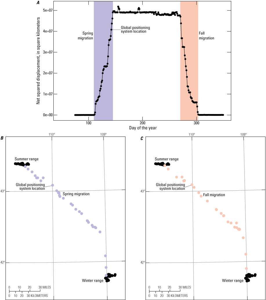
Example of Net Squared Displacement (NSD) analysis to identify migration sequences (from Kauffman and others, 2020). A, breakpoints in the NSD curve provide the start and end dates for the spring migration, when an animal migrates from the winter range to the summer range, and the fall migration, when an animal leaves its summer range to return to the winter range; B, the corresponding global positioning system (GPS) locations are highlighted on the map insets for the spring migration; C, the GPS locations are highlighted on the map insets for the fall migration. For ease of readability, only one GPS location per day is shown. [e+, e-notation]
Calculating Probability of Use with Brownian Bridge Movement Models
Once migration sequences were extracted for each individual in a given year, we used a Brownian bridge movement model (BBMM; Horne and others, 2007) to estimate a utilization distribution (UD) representing the probability of use during migration. The UD produced from the BBMM provides a probability surface, or heat map, of the area used in each migration sequence. Additionally, the outer bounds of the UD provide estimated widths of the movement path around the straight line between an animal’s two successive locations. Together, the heat map and boundary of the UD can be used to identify migration corridors (Sawyer and others, 2009) and the stopover sites where animals spend extended time foraging along their migration route (Sawyer and Kauffman, 2011).
To generate the heat map for each migration sequence, we used the BBMM to estimate a UD with a grid resolution of 164 feet (50 meters). When GPS collars failed to record a location at a given time and breaks in the sequential data exceeded an 8–14-hour time lag, we did not build a bridge between the two locations encompassing the break. A key parameter of the BBMM is the Brownian motion variance (BMV), which provides an index of the mobility of the animal under observation (Horne and others, 2007). An empirical estimate of the BMV was obtained for each migration sequence using the methods of Horne and others (2007). We did not include migration sequences with a BMV greater than or equal to 1.98 acres (8,013 square meters [m2]) because large BMV values poorly represented the observed migration trajectory.
Variations of the Brownian Bridge Movement Model Method—Sparse Data and Fixed Motion Variance
When location data are sparse (in other words, when there is a long time interval between GPS locations), the BBMM performs poorly because of the increased uncertainty in the movement path between two successive GPS locations. Such uncertainty tends to overestimate the corridor width and area (Horne and others, 2007; Benhamou, 2011). To facilitate corridor analyses of migration sequences collected with low relocation rates (in other words, fix rates), we used the alternative Fixed Motion Variance method, in which we set the BMV at specific levels when estimating the UDs for each migration sequence (Kauffman and others, 2020; McKee and others, 2024). For herds with sparse sampling data, we set the BMV between 0.15 and 0.40 acres (607 and 1,619 m2, respectively) for Cervus canadensis (elk) and Antilocapra americana (pronghorn) and between 0.10 and 0.30 acres (405 and 1,214 m2, respectively) for Odocoileus hemionus (mule deer; McKee and others, 2024).
For most analyses, traditional BBMM methods were used to estimate corridors and stopovers. However, when there were large amounts of missing data in the migration sequences, corridors were calculated using Fixed Motion Variance if they improved delineation as observed through a visual comparison of maps from the two methods. When fix rates were highly variable among individuals in a herd, BBMM and Fixed Motion Variance methods were used to construct individual UDs. In general, by bridging gaps in the probability surface created by missing GPS locations, Fixed Motion Variance provided a modeled corridor that more closely matched data with frequent relocations (for example, a 2-hour fix rate; McKee and others, 2024). In most of these analyses, a 14-hour time lag was allowed; a 27-hour or 48-hour time lag was allowed only when it provided more complete migration corridors compared to using a 14-hour time lag.
Calculating Population-Level Corridors and Stopovers
We applied a three-step process to calculate population-level corridors and to identify stopovers; the process generally followed the methods developed by Sawyer and others (2009). First, we averaged the UDs for a given individual’s spring and fall migration sequences across all years to produce a single, individual-level migration UD. We rescaled this mean UD to sum to one. Second, we defined a migration footprint for each individual as the 99-percent isopleth of its UD. We then stacked all the individual footprints for a given population, which provided a raster representing the number of animals that used each grid cell during migration. Next, we defined different levels of corridor use on the basis of the proportion of the collared migrants in the population for a given grid cell. For most herds, we then defined low use corridors as areas traversed by at least one collared individual during migration, medium use corridors as areas used by 10–20 percent of the collared individuals, and high use corridors as areas used by more than 20 percent of the collared individuals in the population. These corridors were converted from a grid-based format to a polygon format, and then isolated-use polygons of less than 4.94 acres (19,991 m2) were removed. Finally, to calculate stopover use, we averaged all the individual-level UDs to produce a single population-level UD, rescaled to sum to one. Stopovers were defined as the areas representing the highest 10 percent of use from the mean population-level UD. We then converted stopovers from a grid-based format to a polygon format, like the corridors, and removed isolated-use polygons of less than 4.94 acres (19,991 m2). The resulting population-level corridors are referred to as “corridors,” “routes,” or “footprints,” depending on the preference of individual States and Tribes.
Variations of the Method to Calculate Population-Level Corridors
The simplest method for delineating migratory corridors was the line buffer approach (Merkle and others, 2023). For this method, we simply buffered the migration lines (lines connecting sequential GPS locations) by a specified distance (for example, 820 feet [250 meters]) and then used the general methods in the “Calculating Population-Level Corridors and Stopovers” section to determine low, medium, and high use areas. The line buffer method serves as a useful alternative to the BBMM methods because it (1) ensures individual routes are the same width and do not vary extensively, (2) ensures population-level routes have full connectivity between seasonal ranges (in other words, no broken segments or overly large areas are produced), (3) easily accommodates variable GPS fix rates, and (4) requires little computing power.
Most maps in this report display low, medium, and high use corridors or routes. However, some individual State and Tribal contributors adapted methods to best suit their management purposes or accommodate the limitations posed by varying sample sizes among herds. The “Data Analysis” section of the page-pair text accompanying each herd provides additional herd-specific details when analysts deviated from the general methods presented herein, for example, when different definitions were used to define the migration corridor or route use levels.
Estimating a Population’s Winter Range
To estimate a population’s winter range, we generally followed the same methods used to calculate migration stopover sites but had some exceptions. First, instead of migration sequences, we isolated winter sequences of GPS locations. For each year, we calculated a standard date for the start and end of winter, and based on the preference of individual States and Tribes, we applied one of three options to calculate winter range dates: (1) for each year, we calculated the start of winter as the 95th percent quantile of the end dates of all fall migrations and the end of winter as the 5th percent quantile of the start dates of all spring migrations, (2) we defined winter as the dates between the end of fall migration and the start of spring migration for each individual, or (3) we defined a fixed date range using local expert knowledge for a given herd (for example, December 15–March 15). We discarded winter sequences that spanned fewer than 30 days. Using the same methods for calculating migration stopovers, we calculated a population-level UD of winter use and identified the core winter range using the 50-percent isopleth. The “Data Analysis” section for the corresponding herd summaries in this report provided additional herd-specific details regarding winter ranges.
Estimating a Population’s Annual Range
To estimate a population’s annual range, we generally followed the same methods used to calculate migration stopover sites or winter range but had some exceptions. First, we isolated annual movement sequences for each individual. These movement sequences were defined as movements longer than 275 days (200 days for California) in a calendar year and began at the time of GPS collar deployment. Start dates were similar because GPS collars were deployed in batches around the same dates. End dates varied depending on individual mortalities. Using the methods for migration corridors, we calculated a population-level UD of annual use and identified the core annual range using isopleth values (for example, 50 and 90 percent contours) selected on the basis of local expert knowledge for a given herd. The “Data Analysis” section for the corresponding herd summaries in this report provided additional herd-specific details regarding annual ranges.
Herd Summary Statistics
In addition to the map for each herd, several summary statistics described the project and associated data. In the “Animal Capture and Data Collection” section for the corresponding herd summaries in this report, sample size was defined as the number of collared individuals (inclusive of residents and migrants), relocation frequency was determined by local researchers and varied within and among herds, and the project duration was defined using the year of the first and last GPS location included in the analyses. In the “Data Analysis” section for the corresponding herd summaries in this report, we provided the number of migration sequences and individuals used in the respective analysis. These numbers accounted for sequences that failed to fit a BBMM and were not included in the delineation of the migration corridor or seasonal range. In the “Corridor and Stopover Summary” section for the corresponding herd summaries in this report, we included the median start and end dates for the spring and fall migrations and the average duration of each migration period in days. Additionally, we defined the migration length as the maximum distance between any two points in a spring or fall migration sequence. These methods helped to avoid overestimating migration distances, which can be inflated when calculated as the sum of all step lengths in a sequence because distances traveled when foraging at a stopover are included. The “Corridor and Stopover Summary” section for the corresponding herd summaries in this report also includes the areas of migration corridors and stopovers.
References Cited
Bastille-Rousseau, G., Potts, J.R., Yackulic, C.B., Frair, J.L., Ellington, E.H., and Blake, S., 2016, Flexible characterization of animal movement pattern using net squared displacement and a latent state model: Movement Ecology, v. 4, no. 1, art. 15, 12 p. [Also available at https://doi.org/10.1186/s40462-016-0080-y.]
Benhamou, S., 2011, Dynamic approach to space and habitat use based on biased random bridges: PLoS One, v. 6, no. 1, art. e14592, 8 p. [Also available at https://doi.org/10.1371/journal.pone.0014592.]
Bunnefeld, N., Börger, L., van Moorter, B., Rolandsen, C.M., Dettki, H., Solberg, E.J., and Ericsson, G., 2011, A model‐driven approach to quantify migration patterns—Individual, regional and yearly differences: Journal of Animal Ecology, v. 80, no. 2, p. 466–476. [Also available at https://doi.org/10.1111/j.1365-2656.2010.01776.x.]
Horne, J.S., Garton, E.O., Krone, S.M., and Lewis, J.S., 2007, Analyzing animal movements using Brownian bridges: Ecology, v. 88, no. 9, p. 2354–2363. [Also available at https://doi.org/10.1890/06-0957.1.]
Kauffman, M.J., Copeland, H.E., Berg, J., Bergen, S., Cole, E., Cuzzocreo, M., Dewey, S., Fattebert, J., Gagnon, J., Gelzer, E., Geremia, C., Graves, T., Hersey, K., Hurley, M., Kaiser, R., Meacham, J., Merkle, J., Middleton, A., Nuñez, T., Oates, B., Olson, D., Olson, L., Sawyer, H., Schroeder, C., Sprague, S., Steingisser, A., and Thonhoff, M., 2020, Ungulate migrations of the Western United States, volume 1 (ver. 1.1, December 2023): U.S. Geological Survey Scientific Investigations Report 2020–5101, 119 p. [Also available at https://doi.org/10.3133/sir20205101.]
McKee, J.L., Fattebert, J., Aikens, E.O., Berg, J., Bergen, S., Cole, E.K., Copeland, H.E., Courtemanch, A.B., Dewey, S., Hurley, M., Lowrey, B., Merkle, J.A., Middleton, A.D., Nuñez, T.A., Sawyer, H., and Kauffman, M.J., 2024, Estimating ungulate migration corridors from sparse movement data: Ecosphere, v. 15, no. 9, art. e4983, 16 p. [Also available at https://doi.org/10.1002/ecs2.4983.]
Merkle, J.A., Gage, J., Sawyer, H., Lowrey, B., and Kauffman, M.J., 2022, Migration mapper—Identifying movement corridors and seasonal ranges for large mammal conservation: Methods in Ecology and Evolution, v. 13, no. 11, p. 2397–2403. [Also available at https://doi.org/10.1111/2041-210X.13976.]
Merkle, J., Lowrey, B., Wallace, C.F., Hall, L.E., Wilde, L., Kauffman, M.J., and Sawyer, H., 2023, Conserving habitat for migratory ungulates—How wide is a migration corridor?: Journal of Applied Ecology, v. 60, no. 9, p. 1763–1770. [Also available at https://doi.org/10.1111/1365-2664.14473.]
Sawyer, H., Kauffman, M.J., Nielson, R.M., and Horne, J.S., 2009, Identifying and prioritizing ungulate migration routes for landscape-level conservation: Ecological Applications, v. 19, no. 8, p. 2016–2025. [Also available at https://doi.org/10.1890/08-2034.1.]
Sawyer, H., and Kauffman, M.J., 2011, Stopover ecology of a migratory ungulate: Journal of Animal Ecology, v. 80, no. 5, p. 1078–1087. [Also available at https://doi.org/10.1111/j.1365-2656.2011.01845.x.]
Conversion Factors
U.S. customary units to International System of Units
Datum
Vertical coordinate information is referenced to the North American Vertical Datum of 1988 (NAVD 88).
Horizontal coordinate information is referenced to the North American Datum of 1983 (NAD 83).
Abbreviations
>
greater than
BBMM
Brownian bridge movement model
BLM
Bureau of Land Management
BMV
Brownian motion variance
CDOT
Colorado Department of Transportation
CMT
Corridor Mapping Team
CPW
Colorado Parks and Wildlife
CWD
chronic wasting disease
DAU
Data Analysis Unit
FS
U.S. Department of Agriculture Forest Service
GPS
global positioning system
NDOW
Nevada Department of Wildlife
NSD
Net Squared Displacement
ssp.
subspecies
UD
utilization distribution
UDWR
Utah Division of Wildlife Resources
USGS
U.S. Geological Survey
WGFD
Wyoming Game and Fish Department
WMU
Wildlife Management Unit
WVC
wildlife-vehicle collision
Publishing support provided by the USGS Science Publishing Network, Denver and Rolla Publishing Service Centers
For more information concerning the research in this report, contact the Associate Director Ecosystems Mission Area
U.S. Geological Survey
Mail Stop 300
12201 Sunrise Valley Drive
Reston, VA 20192
Disclaimers
Any use of trade, firm, or product names is for descriptive purposes only and does not imply endorsement by the U.S. Government.
Although this information product, for the most part, is in the public domain, it also may contain copyrighted materials as noted in the text. Permission to reproduce copyrighted items must be secured from the copyright owner.
Suggested Citation
Kauffman, M., Lowrey, B., McKee, J.L., Beaupre, C., Beck, J., Beckmann, J., Bergen, S., Berger, J., Berkley, R., Borg, N., Carl, P., Cowardin, M., Dewey, S., Dugger, K.M., Ehrhart, A., Fort, J., Freeman, E., Freeman, I., Gelzer, E.R., German, D., Gray, J., Greenspan, E., Gregory, Z., Hagler, E., Hanson, M., Hinojoza-Rood, V.D., Hnilicka, P., Jaffe, N., Jakes, A.F., Johnson, A., Kolek, J.T., Lawson, A., Lockyer, Z., Lutz, D., McKee, C., McKeever, J., Merkle, J., Mumma, M.A., Newman, D., Peckham, E., Randall, J.E., Regan, T., Reinking, A.K., Ritson, R., Rudd, W.J., Russo, B.M., Sawyer, H., Schroeder, C., Scurlock, B., Short, J., Stansberry, B., Steiner, E., Steingisser, A., Stephenson, T., VanNatta, E., Wallace, C.F., Weinmeister, B., Whittaker, D., Woody, T., and Yancey, S., 2026, Ungulate migrations of the Western United States, volume 6: U.S. Geological Survey Scientific Investigations Report 2026–5123, 68 p., https://doi.org/10.3133/sir20265123.
ISSN: 2328-0328 (online)
ISSN: 2328-031X (print)
Study Area
| Publication type | Report |
|---|---|
| Publication Subtype | USGS Numbered Series |
| Title | Ungulate migrations of the Western United States, volume 6 |
| Series title | Scientific Investigations Report |
| Series number | 2026-5123 |
| DOI | 10.3133/sir20265123 |
| Publication Date | March 25, 2026 |
| Year Published | 2026 |
| Language | English |
| Publisher | U.S. Geological Survey |
| Publisher location | Reston VA |
| Contributing office(s) | Coop Res Unit Seattle |
| Description | Report: x, 68 p.; Data Release |
| Country | United States |
| State | Arizona, California, Colorado, Idaho, Montana, Nevada, New Mexico, Oregon, Utah, Wyoming |
| Online Only (Y/N) | N |