|
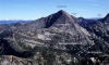
Kpv-1. View southeast down Methow River valley [RMsw]. In the middle distance volcanic rock and redbeds (Kpv) overlie fluvial sandstone (Kps), both of the Pasayten Group, in the west limb of the Goat Peak Syncline. Redbeds, the Ventura Member of Midnight Peak Formation of Barksdale (1975), also crop out on left (closer). Qt, talus; Qa, alluvium of valley bottoms. Contacts (thin lines) and faults (thick lines) dashed where approximately located. Goat Wall is about 1,100 m high. View image without annotation
|