
|
|
Scientific Investigations Map 2940 |
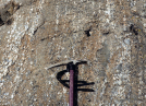
| Kps-5. Mold of stump in base of chert-gravel conglomerate bed, sedimentary rocks of the Pasayten Group of Kiessling and Mahoney (1997) (Kps). Center of stump is at knee height below outstretched hand, note radiating roots. Such stump molds are among the evidence that the Virginian Ridge Formation of Barksdale (1975) is fluvial. Hillside west of Huckleberry Creek, 2.5 km north of Gardner Mountain [RMse]. |

|
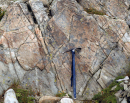
Other photos that show unit Kps:
     |
  |