|
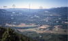
QTl-1. View southeast from ridge northeast of Swakane Creek towards Badger Mountain [Cse], dominated by landslides (QTl) from Yakima Basalt flows (Tyg). Where underlain by weak sedimentary interbeds of the Ellensburg Formation (Te, not visible here), the massive basalt flows commonly collapse into large landslides. Here, landslides partially bury Wenatchee Formation (Ohanepecosh episode, Tcao) that overlies Swakane Biotite Gneiss (Kswg). Turtle Rock is a single large block of gneiss, an erosional remnant of a landslide. Terraces of Pleistocene Missoula flood deposits (Qgf) line the Columbia River. A small alluvial fan mapped as Qu is also shown. Contacts dashed where approximately located and dotted where concealed. View image with annotation
|