
|
|
Scientific Investigations Map 2940 |
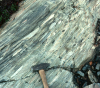
| TKcs-2. Cascade River Schist (TKcs) exposed below the glacier in the Middle Fork Cascade River [SRne], northeast flank of Mount Formidable. Mafic schist contains large flattened clasts derived from volcanic breccia and tuff. Note ice ax, lower right corner, for scale. |

|
Other photos that show unit TKcs:
      |