Scientific Investigations Report 2005-5286
U.S. GEOLOGICAL SURVEY
Scientific Investigations Report 2005-5286
In order to identify losing or gaining reaches within the lower Virgin River, synoptic-measurement sites were selected based upon the location of (1) tributary inflow; (2) streamflow diversions; (3) potential ground-water inflow, including irrigation returns; and (4) accessible measuring sections. These measurements were made during a period of minimal ET and steady baseflow.
February was selected for the measurement period because ET rates are very low during this time of the year. The measured evaporative rate, determined for a dense area of saltcedar within the lower Virgin River, for February 12, 2003, was 0.2 millimeter per day (Guy DeMeo, U.S. Geological Survey, oral commun., July 12, 2005). Although this rate only represents a selected reach, it is considered the maximum rate within the lower Virgin River because all other areas contain less dense saltcedar growth. Based on this daily ET rate, instream losses resulting from ET are less than the error in discharge measurements.
During the course of the synoptic measurements, discharge measurements were made at four agricultural diversions within the lower Virgin River (Littlefield, Mesquite, Bunkerville, and Riverside). Another diversion, called the Petrified Spring diversion, diverts flow from a spring on the south bank between the I-15 bridge and the Littlefield gage (fig. 1). This diversion was inaccessible on February 12, 2003; however, the amount of water diverted was reported previously at 2–3 ft3/s (Dixon and Katzer, 2002). Flow in the Littlefield diversion originates from Beaver Dam Wash (fig. 1) and is conveyed by a ditch along the north bank of the Virgin River to the town of Littlefield. Flow in the ditch on February 12, 2003, measured 0.45 ft3/s, which amounts to less than 1 percent of the measured flow at the Littlefield gage. Measured discharge in the Mesquite, Bunkerville, and Riverside diversions during the synoptic-measurement period was 27.3, 103, and 32.1 ft3/s, respectively. Although the Bunkerville diversion diverted nearly 80 percent of the diverted flow from the Virgin River, most of that water was observed returning back to the river through several concrete channels upstream of site 09415105 (Virgin River at Bunkerville; fig. 2).
Although the weather on February 12, 2003, was cool with light rain during the measurement period, near baseflow conditions were believed to be present throughout the entire lower Virgin River. Unit-value discharge hydrographs of three USGS continuous-recording gaging stations shown in figure 4 indicate that a small peak flow, either from precipitation or water released within the upper watershed, had entered the lower Virgin River during the early morning of February 11, 2003. The crest of the peak flow passed through the Narrows gage about 2:00 a.m. and subsequently passed through the Littlefield gage about 5:30 a.m. Although significantly attenuated, the crest passed through the Overton gage about 2:15 a.m. on February 12. Between the Littlefield and Overton gages, the travel velocity of this peak flow was estimated at 1.8 mi/h. Using this velocity, the peak flow would have taken about 3 hours to travel the 5.1 mi from the Overton gage to the last measurement site 09415250 (Virgin River above Lake Mead near Overton). Although the peak flow probably crested between 5:00 and 5:30 a.m. on February 12, discharge measurements taken at the lower site probably were made during the decline, but at higher stages of the peak flow. To confirm this assumption, another synoptic set of discharge measurements was made at the two lower sites during known baseflow conditions on March 27, 2003. Mean discharges computed for the gage near Overton and site 09415250 (Virgin River above Lake Mead near Overton) were 101 and 104 ft3/s, respectively. The discharge rates at these two sites are considered similar because the difference between the two measurements falls well within the measurement error of 5 percent. The synoptic measurements made at site 09415250 (Virgin River above Lake Mead near Overton) on February 12, 2003, may have been influenced by the peak flow; therefore, they were not used for this evaluation.
In general, results of the synoptic-discharge and water-property measurements indicate three discernible trends. The first trend is a net increase in discharge, specific conductance, and water temperature between sites 09413700 (Narrows gage) and 09415000 (Littlefield gage). The second trend is a net decrease in discharge and water temperature between sites 09415000 (Littlefield gage) and 09415240 (Virgin River near Overton). The third trend is a net increase in specific conductance between sites 09415000 (Littlefield gage) and 09415240 (Virgin River near Overton).
The increase in discharge, water temperature, and specific conductance between sites 09413700 (Virgin River above the Narrows) and 09415000 (Virgin River at Littlefield) is well documented and primarily is the result of inflow from the Littlefield Springs (Dixon and Katzer, 2002). On February 12, 2003, the gains in discharge, water temperature, and specific conductance were 67.5 ft³/s, 5.5°C, and 130 µS/cm, respectively.
The net decreases in discharge and water temperature between sites 09415000 (Virgin River at Littlefield) and 09415240 (Virgin River near Overton) were 42 ft3/s and 4.0ºC, respectively. The net increase in specific conductance between the same sites was 450 µS/cm; however, the greatest change occurred between sites 09415089 (Virgin River above Bunkerville Diversion) and 09415198 (Virgin River below Meadowlands Farm; fig. 2) and seems to change downstream from the flow diversions. Though some minor perturbations exist within these trends, the general trends in discharge, water temperature, and specific conductance seem consistent with a river basin where surface water is diverted for agricultural and municipal purposes, and some diverted water is recycled back into the river through the shallow ground-water system downstream of the diversions.
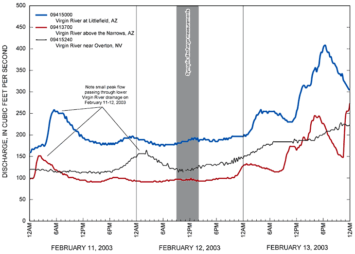
Figure 4. Unit discharges for U.S. Geological Survey surface-water gaging stations 09413700 Virgin River above the Narrows, Arizona; 09415000 Virgin River at Littlefield, Arizona; and 09415240 Virgin River near Overton, Nevada, February 11-13, 2003.

![]() U.S. Department of the Interior |
U.S. Geological Survey
U.S. Department of the Interior |
U.S. Geological Survey
Persistent URL: https://pubs.water.usgs.gov/sir20055286
Page Contact Information: Publications Team
Page Last Modified: Thursday, 01-Dec-2016 18:51:32 EST
