|
U.S. Geological Survey Multibeam Data and Socio-Economic Issues in West-Central San Francisco BaySediment Transport
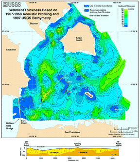
The distribution of sediment types that cover the bayfloor and the patterns and rates of transport of these materials are important factors in all of the issues discussed. The sediment thickness map, calculated from a depth to bedrock map (Carlson and McCulloch, 1970) derived from acoustic profiles acquired in the 1960s and from the new multibeam bathymetry, shows that more than 90 meters (295 feet) of sediment covers parts of the west-central San Francisco Bay area.
|
||||||||
|
||||||||

![]() U.S. Department of the Interior | U.S. Geological Survey
U.S. Department of the Interior | U.S. Geological Survey
URL: https://pubs.usgs.gov/of/1998/of98-139/sedtrans.html
Contact: John Chin
Page Maintained By: Michael Diggles
Page Created By: Laura Zink Torresan
Page Last Modified: 10 October 2008