|
| Sediment CoresTen short sediment cores (Appendix B) were obtained from the Port Neches (6) and Caplen (4) field sites (Figs. 2 and 4). The cores, which range in length from 0.5 to 1.15 m, were transported to the USGS Center for Coastal and Regional Marine Studies at St. Petersburg, Florida. There each core was split, photographed, described, and archived. Cores from the Port Neches Field were collected in open water near the marsh edge to evaluate the magnitudes of subsidence or erosion. An exception is core BH-00-01, which was taken at the marsh edge to establish the natural thickness of marsh sediments. At the Caplen Field, two pairs of cores were taken from the marsh and adjacent open water perpendicular to surface fault traces. The sites were selected to sample the upthrown and downthrown sides of the east-west and north-south trending faults (Fig. 4). All of the cores coincide with one of the topographic profiles (Appendix A). Core Descriptions and Sediment Types
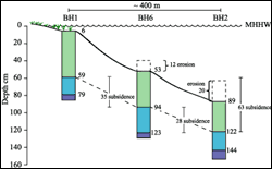
The four cores from the Caplen Field recovered some or all of the same three sedimentary facies observed in the Port Neches cores, two of the cores recovered an additional facies, which is sandy mud. The general facies colors and compositions in stratigraphic order from top to bottom are: (1) black organic mud with abundant roots, and dark gray and light gray mud with some roots, (2) light gray or light brown sandy mud, and (3) mud and sand in horizontal juxtaposition. The light-colored mud and sand-mud facies are mottled to faintly laminated. Cores COF-00-03 and 04 recovered all three facies, whereas cores COF-00-01 and 02 recovered primarily the upper two facies. The complete upward-fining stratigraphic section records upward shoaling and establishment of a marsh with increased organic-sediment production and decreased clastic sedimentation. Comparing the shallow wetland stratigraphy at Port Neches and Caplen reveals that the organic-rich sediments are substantially thicker at Port Neches (> 30 cm) than at Caplen (< 20 cm) probably because of the aggradational floodplain setting at Port Neches. The clastic sediments contain more sand at Caplen because of a barrier-island setting. Stratigraphic Correlations and Subsidence-Erosion CalculationsThe following methods were used to estimate the magnitude of subsidence or erosion by comparing the stratigraphy of adjacent cores. Core pairs were placed on a laboratory bench and juxtaposed so that the marker horizons or sedimentary facies correlated. The correlated horizons were marked with labels, and the depths from the top of the core to each marker horizon were recorded. Cores were then placed in their proper vertical positions relative to surface elevations and water depths in the field. The depth differences of the labeled markers were measured, and an estimate of subsidence was calculated as well as the indicated depth of erosion. Stratigraphic correlations were established among all cores except BH-00-04, which came from a different geologic setting where the transition from floodbasin muds to marsh sediments is not present. The subsidence and erosion estimates depended on the assumptions that: (1) the thickness of marsh sediments at BH-00-01 (53 cm) is a reasonable estimate of original marsh sediment thickness at each core location, and (2) there has been no subsidence or erosion at BH-00-01. If the original marsh thickness at a site was less than 53 cm, then the methods underestimate subsidence and overestimate erosion. Most of the cores at Port Neches were taken along the marsh edge bordering open water (Fig. 2) to compare the thickness of extant marsh sediments at the surface with the thickness of organic-rich mud (marsh sediments) preserved beneath the water. One core (BH-00-02) was taken approximately 400 m toward the center of the bowl-shaped area of wetland loss to sample the thickness of organic-rich mud away from the marsh edge that might be influenced by wave and current erosion. Three cores collected from the western side of Port Neches (BH-00-01, BH-00-02, and BH-00-06) were correlated to determine the amount of subsidence or erosion that has taken place from the marsh edge toward the center of the open-water area. All three cores exhibit three distinct vertical sedimentary facies changes that can be correlated (Fig. 9). Between BH-00-01 (core of marsh surface) and BH-00-06 (core near marsh edge) there were approximately 35 cm of subsidence and 12 cm of marsh erosion. Between cores BH-00-06 and BH-00-02 (farthest from marsh edge) approximately 28 cm of subsidence and 8 cm of erosion were measured (Fig. 9). Comparing cores BH-00-01 and BH-00-02, 63 cm of subsidence and 20 cm of erosion were measured. At core site BH-00-05 (Fig. 2), about 36 cm of subsidence and 21 cm of erosion are estimated from the thickness of organic mud with abundant roots at the top of the core (32 cm) and the adjusted water depth (63 cm) at the site. The thickness (0.59 m) of organic-rich sediments at the top of core BH-00-03 suggests that none of the marsh sediments has been eroded from that site and the adjusted water depth (0.87 m) is a reasonable estimate of subsidence.
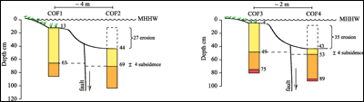
Caplen core pairs COF-00-01 and COF-00-02, and COF-00-03 and COF-00-04 were correlated to determine the amount of subsidence or erosion. Land-surface changes at the Caplen Field were determined by correlating marker horizons in two pairs of cores taken on the upthrown and downthrown sides of the reactivated faults (Fig. 10). Stratigraphic correlations between COF-00-01 (upthrown) and COF-00-02 (downthrown) indicate a downthrown offset (subsidence) of only 0.04 m across the east-west trending fault, whereas approximately 0.31 m of the top of core COF-00-2 is absent as a result of erosion. The organic-rich zone representing the marsh surface is missing from COF-00-02 (Fig. 10). Three distinct vertical facies changes can be correlated in the pair of Caplen cores (COF-00-03 and COF-00-04) taken across the north-south trending fault (Fig. 10). Correlation of the upper two stratigraphic horizons indicate 0.04 m of subsidence, whereas vertical displacement of the lower stratigraphic horizon indicates 0.19 m of subsidence. The lower section of core COF-00-03 may have experienced core shortening (Morton and White, 1997), which would explain the difference in measured subsidence at the upper and lower horizons. The stratigraphic correlations also indicate that core COF-00-04 was taken at a location where approximately 0.39 m of the organic-rich marsh and underlying sediments have been removed by erosion. Historical and Geological Subsidence RatesA subsidence rate can be approximated for the Port Neches Field by integrating the spatial data presented in Fig. 5 (line AB) and the temporal data presented in White and Morton (1997). According to that information, the wetland surface at Port Neches subsided about 64 cm between 1956 and 1978 (22 yrs). These values yield a short-term average rate of wetland subsidence of nearly 3 cm/yr. The estimated subsidence rate may be conservative because the maximum period was used to calculate the rate. Although the observed subsidence occurred after 1956 and before 1978, it is unclear when the maximum vertical displacement occurred. The similarity in areal wetland loss in 1978 compared with present (2000) conditions suggests that the subsidence was rapid initially, but then slowed or possibly stopped. It is not likely that subsidence would be sustained indefinitely. Instead, the duration of surficial adjustment to subsurface perturbations is probably related to the history of production. There was a hiatus between the onset of production and the first visible evidence of surface disturbance and wetland loss. Whatever losses are occurring today, they are occurring at a much slower rate than when the wetlands collapsed between 1956 and 1978. This temporal reduction in rates of subsidence corresponds with the rapid decline in hydrocarbon production. The estimated rate of production-induced subsidence at Port Neches (3 cm/yr) is rapid compared to natural rates of subsidence in the Gulf Coast region over geological time scales. For example, geological rates of subsidence are known to be relatively rapid in parts of the Mississippi delta. Some of the highest long-term average rates of subsidence in south Louisiana are on the order of 1 cm/yr (Roberts et al., 1994; Kulp and Howell, 1998). However, most of the peats more than 200 years old yielded subsidence rates less than 0.5 cm/yr. The highest geological rates of subsidence were located where the Holocene delta deposits are thickest. The young, water-saturated peats and muddy delta sediments have the greatest potential for rapid subsidence as the sediments naturally dewater and compact. Farther to the west, away from the incised valley where Holocene sediments are thickest, calculated rates of natural subsidence are on the order of 0.04 cm/yr (Roberts et al., 1994). The short-term historical rates of subsidence at Port Neches (3 cm/yr) are essentially three times the highest long-term average rates of subsidence in a region that is known for rapid subsidence. Considering the geological setting at Port Neches with the underlying overcompacted Pleistocene sediments, the 3 cm/yr rate is relatively high compared to expected natural rates of subsidence. The historical subsidence rates at Port Neches are 75 times the geological rates in the delta plain of southwestern Louisiana, which is the closest area with subsidence data having a similar geologic setting. |