| |  |  | | Lake Pontchartrain Atlas: | | | | | | | | | | | | | | | | | | | | | | | | | | | | Biological Resources |  | | | | | | | | | | | | | | | | |  | | | | | | | | | | |  | Biological Resources - Habitat Inventory Contributors: Handley , Hartley, Johnston, O'Neil, Braud, Snead - Lake Pontchartrain Basin - Land Use/Land Cover
Louisiana Gap Satellite Imagery The National Gap Analysis Program (GAP) has been underway since 1988 and is managed by the USGS, Biological Resources Division. The GAP is a national partnership designed to identify areas of ecological significance that could be managed to conserve biological diversity. It seeks to identify the "gaps" in our system of conservation lands. The information can be used to help guide conservation actions and changes in management that are necessary to protect or restore ecosystem function and prevent species from becoming endangered. The land cover data used for this map were generated as part of the Louisiana GAP Project by the National Wetlands Research Center (NWRC) in Lafayette, Louisiana (Figure 1). 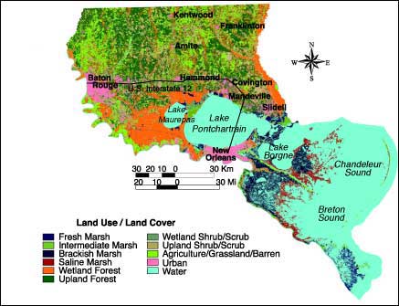 | | Figure 1: Land use/land cover map generated by the Louisiana Gap Project for the LPB. Click on the image for a larger version (64K). | | Land Use/Land Cover | Acres | Percent | | Fresh Marsh | 82,601 | 2.14 | | Intermediate Marsh | 36,457 | 0.94 | | Brackish Marsh | 204,707 | 5.30 | | Saline Marsh | 125,567 | 3.25 | | Wetland Forest | 844,212 | 21.87 | | Upland Forest | 1,076,530 | 27.89 | | Wetland Shrub/Scrub | 46,874 | 1.21 | | Upland Shrub/Scrub | 454,557 | 11.78 | | Agriculture/Grassland/Barren | 688,702 | 17.84 | | Urban | 300,116 | 7.77 | | The upper portion of the map, north of U.S. Interstate 12, was produced from three scenes of Landsat Thematic Mapper satellite imagery acquired from November 11, 1992 through March 7, 1993. The data were obtained from the Earth Observation Satellite Company (EOSAT) and were georectified by EOSAT to the Universal Transverse Mercator Projection, zone 15, and resampled to 25-meter cells. The image was constructed from a red, green, blue (RGB) composite of bands 4,5,3 for each scene and a mosaic was created from these three scenes. The land cover data resulted from a classification of the satellite data into the categories listed. The lower portion of the image, south of U.S. Interstate 12, was developed from the digital wetland and upland habitat data generated by the National Wetland Inventory (NWI) and the NWRC from photointerpreted 1988 National Aeronautics and Space Administration (NASA) 1:65,000-scale color infrared aerial photography. NASA 1995 color infrared aerial photography and ground truthing have been used to verify and assess the accuracy of the land cover categories within the map. The wetland and upland habitat data and the satellite imagery were merged and trimmed to the LPBF's program boundaries within the state of Louisiana. « Previous | Next » |
