| |  |  | | Lake Pontchartrain Atlas: | | | | | | | | | | | | | | | | Environmental Status & Trends |  | | | | | | | | | | | | | | | | | | | | | | | | | | | | |  | | | | | | | | | | |  | Environmental Status and Trends - Status and Trends of the Lake Pontchartrain Basin Contributors: Penland, Beall, Maygarden 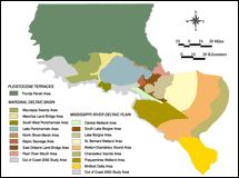 | | Figure 1: Areas within the geomorphic regions of the Pleistocene Terraces, Marginal Deltaic Basin and Mississippi River Deltaic Plain (source: www.coast2050.gov). Click on the image for a larger version. | | | | 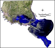 | | Figure 2: Satellite image of the LPB. Click on the image for a larger version. | | Assessing the status of the LPB is a complex task due to the great diversity of natural environments within the entire watershed. In order to present the information in a manageable way, the discussion is divided according to the Basin's three major geomorphic regions: Pleistocene Terraces, Marginal Deltaic Basin and Mississippi River Deltaic Plain (see Figure 5, Environmental Overview). A satellite image of the LPB is shown in Figure 2 to use as a reference for areas commonly referred to throughout this section. Environmental status and trends refers to the current state of fish and wildlife populations, and whether their numbers are increasing (I), declining (D), or remaining steady (S). Each of these three regions is further subdivided into areas with distinct habitat characteristics, plant communities and assemblages of fauna (Figure 1). Criteria used in the assessment of the status and trends include fish and wildlife populations, water quality and wetland loss. The information on status and trends of living resources (Tables 2, 3 and 4) was obtained from the Coast 2050 Program (Louisiana Coastal Wetlands Conservation and Restoration Task Force and the Wetlands Conservation and Restoration Authority, 1999). This program has analyzed the status and trends of a range of wildlife species and groups of species in the coastal zone of Louisiana. This was achieved through a collaborative effort among the Louisiana Department of Wildlife and Fisheries (LDWF), National Marine Fisheries Service (NMFS), United States Fish and Wildlife Service (USFWS) and the Natural Resources Conservation Service (NRCS). In the LPB, this information excludes the Pleistocene Terraces region because it is not in the coastal zone. Due to the complexity of the information and multiple factors affecting the condition of wildlife and fisheries populations, Coast 2050 recommends viewing the population projections with caution. The ecological status of the Pleistocene Terraces region is analyzed using information compiled for St. Tammany Parish by the Department of Wildlife and Fisheries Natural Heritage Program and used by the St. Tammany Parish 2025 Comprehensive Plan (see Table1). This information is not currently available for the other Florida Parishes. Water quality information was obtained from the EPA's IWI . It compiles state-generated water quality data into comparative indices of condition and vulnerability for watersheds around the country. Vulnerability refers to the potential for a watershed to be damaged by pollution. The IWI information for the sub-basins of the LPB is condensed into graphic form in Figure 10, Environmental Overview. The LDEQ water quality data are used to assess the suitability of water bodies for use by people in various activities including swimming, boating and fishing. From this information designated use standards for monitored water bodies are set. The state also issues fish consumption advisories for those bodies of water where fish tissue analysis shows contamination by toxic chemicals such as heavy metals, particularly mercury. Wetland loss data were obtained from Coast 2050, which divides the Louisiana coastal zone into regions for restoration purposes. These differ from the geomorphic regions described here. The majority of the Marginal Deltaic Basin and much of the Mississippi River Deltaic Plain fall into the Coast 2050 Region 1, while the Birdfoot Delta and Plaquemines Wetland Area fall into Coast 2050 Region 2. For Coast 2050 boundaries, see Existing and Predicted Land Loss Trend 1956 - 2050. « Previous | Next » |
