USGS Home - www.usgs.gov
Coastal and Marine Geology Program
Coastal & Marine Geology Program > Center for Coastal & Regional Marine Studies > Environmental Atlas of Lake Pontchartrain

Environmental Atlas of the Lake Pontchartrain Basin

Lake Pontchartrain Atlas Home
Lake Pontchartrain Atlas:
Preface
Table of Contents
Introduction
Environmental Overview You are at the Environmental Overview section of the Environmental Atlas of Lake Pontchartrain
Environmental Status & Trends
Restoration
Physical Environments
Basin Geology
Biological Resources
Environmental Issues
Bibliography
Resources
Contributors
Acronyms
Contact:
Jack Kindinger
Environmental Overview: Satellite Image of the Lake Pontchartrain Basin | Regional Description

Environmental Overview - Satellite Image of the Lake Pontchartrain Basin

Satellite composition image of northern Gulf of Mexico (1998). Image courtesy of M-SAT.
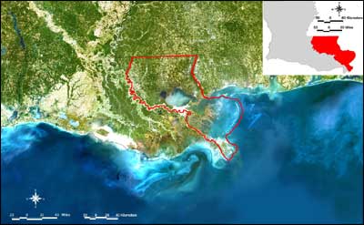
Figure 1: Satellite composition image of northern Gulf of Mexico (1998). Image courtesy of M-SAT. The red outlined area indicates the Lake Pontchartrain Basin. Click on the image for a larger version.

« Previous | Next »


Coastal & Marine Geology Program > Center for Coastal & Regional Marine Studies > Environmental Atlas of Lake Pontchartrain

FirstGov.govemail Feedback [an error occurred while processing this directive]