| |  |  | | Lake Pontchartrain Atlas: | | | | | | | | | | | | | | | | | | | | | | Physical Environments |  | | | | | | | | | | | | | | | | | | | | | | |  | | | | | | | | | | |  | Physical Environments - Relative Sea Level Contributors: Ramsey, Beall, Howard, Strimas, Peters, Penland - Mean Sea Level Rise In Lake Pontchartrain
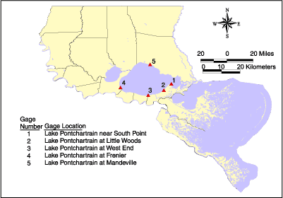 | | Figure 68: Location map for USACE tide gage stations. | The U.S. Army Corps of Engineers (USACE) has maintained tide gages in Louisiana since 1933 when it established the first station at Morgan City on the Intracoastal Waterway. The USACE tide gage stations record a water level measurement at 8:00 a.m. daily. Data from ten USACE tide gage stations in the LPB were analyzed for this study to determine relative sea level rise (Figures 68 and Table 9) (Penland and Ramsey, 1990). Daily USACE water level measurements were averaged and summarized in mean monthly and mean annual tables. The mean annual history was then plotted against time (Figures 69-73). A linear regression was performed to produce a best-fit line with a slope to equal rate of change in sea-level. This analysis was performed for the entire record. Maintenance records for each station were examined to correct errors in the data set. | Table 9: Tide gage and sea-level rise data for the Lake Pontchartrain Region | | Gage # | Gage Location | Location | Sea Level Rise | | 1 | Lake Pontchartrain near South Point | 800' NE of Hwy 11 Bridge at Irish Bayou, East Bank | 1.01 cm/yr | | 2 | Lake Pontchartrain at Little Woods | 200' E of the intersection of Paris Rd. and Haynes Blvd. | 1.09 cm/yr | | 3 | Lake Pontchartrain at West End | 30' E of Municipal Yacht Building, West End Harbor | 0.40 cm/yr | | 4 | Lake Pontchartrain at Frenier | 200' off shore from Service Road | 0.36 cm/yr | | 5 | Lake Pontchartrain at Mandeville | 0.5 miles N of Plaza Bridge at South Bound Lane of the Lake Pontchartrain Causeway Bridge | 0.45 cm/yr | | 1 inch = 2.54 cm | | 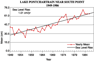 | | Figure 69: Mean annual water level measurements for Lake Pontchartrain near South Point including rate of sea-level change for the area. | 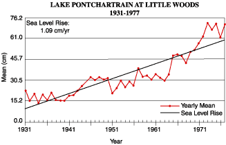 | | Figure 70: Mean annual water level measurements for Lake Pontchartrain near at Little Woods including rate of sea-level change for the area. | 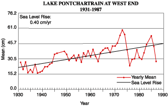 | | Figure 71: Mean annual water level measurements for Lake Pontchartrain near at West End including rate of sea-level change for the area. | 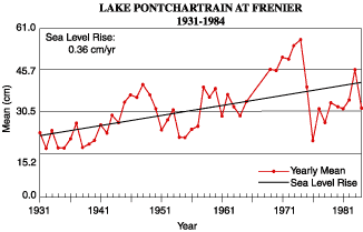 | | Figure 72: Mean annual water level measurements for Lake Pontchartrain near at Frenier including rate of sea-level change for the area. | 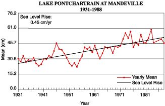 | | Figure 73: Mean annual water level measurements for Lake Pontchartrain near at Mandeville including rate of sea-level change for the area. | « Previous | Next » |
