USGS Open-File Report 03-474, G1-03-GM, Gas Hydrates Cruise Report, R/V Gyre, 1-14 May 2003, Northern Gulf of Mexico
Title Page
Abstract
Introduction
Acknowledgments
Geologic Settings
Cruise Objectives
Cruise Strategy
Instrumentation
Data Processing
Data Handling
Marine Mammal Mitigation
Operational Summary
SUCCESS IN MEETING OBJECTIVES
Summary
References
Appendices
1. Multichannel
Line Statistics
2. Summary of
Digital Data
3. Marine
Mammal
Documents
4. Science
Roster
5. Ship Roster &
Specifications
6. Photo Gallery
Success in Meeting Objectives
Cruise G1-03-GM, in collecting 1033 km of MCS data along 101 lines, has provided a large amount of new data for understanding hydrate occurrence in two regions of the north-central Gulf of Mexico. Together with the ties to previous surveys, core locations, and well data, this new data set offers new insights into the shallow geological processes within the hydrate stability zone. A quick review of the objectives of the survey shows that each of the primary objectives has been met with considerable success:
- Characterize the shallow seismic stratigraphic framework of the two site survey areas:
The data acquired in both survey regions shows abundant reflections and reflection geometries that should enable both the structural and stratigraphic framework to be interpreted. The close line spacing and numerous line crossings will allow for an internally consistent interpretation to be traced through each area. Where reflections are not always continuous (e.g., around the mound/vent sites in Atwater Valley), the data should allow patterns of reflectivity to be mapped, providing another dimension to the interpretation. This objective is considered fully met. - Acquire data to map the distribution of acoustic indicators of gas hydrate:
The multichannel seismic data contain a rich variety of acoustic information about the sea floor and sub-sea floor environment. Preliminary assessment of the data shows that the right types of acoustic indicators of hydrate are present (e.g., cross cutting relations that might indicate a BSR, blanking zones, strong amplitudes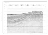
Figure 4. Click on figure for larger image with caption.
indicative of gas, Fig. 4 and Fig. 6 ). A high-amplitude, continuous BSR was not obvious in the Keathley Canyon data, although shorter segments may have been imaged. The many diffractions on most of the data will need to be migrated to more accurately depict the reflection geometries. Without fully interpreting and mapping the acoustic indicators for hydrate, it is not possible to evaluate whether the objective of mapping them is reached. Mapping will be completed as a post-cruise project. This objective is considered to be successfully met.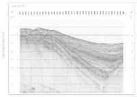
Figure 6. Click on figure for larger image with caption. - Tie to pre-existing public-domain seismic data and available well information:
Each of the survey areas included ties to nearby pre-existing seismic, well, and core data. Hence this objective is considered to be successfully met. It remains a post-cruise task to interpret the ties and to establish whether the geologic framework can be integrated into this pre-existing framework. - Identify transects to reoccupy with near-bottom instrumentation:
Identifying transects to reoccupy will come from post-cruise analysis that results in maps of features and sets the geologic framework. In achieving the three previous goals, there are excellent targets to consider, and it is expected that this objective will be fully achieved in the post cruise analysis phase of the project. - Contribute to selecting potential targets for gas hydrate drilling:
As with the previous objective, the seismic data collected on G1-03-GM need to be integrated with other data to know their ultimate value in determining and prioritizing drilling targets. However, the data are an excellent start in building a high-resolution framework for the two potential drilling areas.
From an operational view, the cruise was also a success. Two notable accomplishments are firsts for at-sea MCS operations for USGS: (i) defining all the acquisition geometry in geographic (rather than relative distance) coordinates and merging this geometry into the SEG-Y data trace headers; and (ii) processing all MCS data with a complete and final processing sequence through stack. The importance of these accomplishments is that all data were viewed in near real-time for quality control and all lines were ready for loading into an interpretation package and for distribution to project partners when the ship returned to the dock, rather than the usual 6-12 months post-cruise time frame for processing MCS data.
The only down time for the MCS system was 4 hours during which a safety valve on the compressor needed replacing. It was a disappointment that the single channel systems could not provide useful data in the water depths (1300 m) of the survey areas, but this was known as a possibility because of operating at the limits of their specifications. The weather and 2-3 m (6-10 ft) seas in the middle of the cruise seriously degraded the quality of the Knudsen bathymetric system, but did not seriously degrade the MCS data. Weather is an unavoidable risk on any cruise, and the bathymetric data are not essential to interpreting the MCS data.
Recommendations for the Future
-
Better weather!
-
Single channel chirp or other high-resolution (>1000 Hz) seismic reflection system with the capability to provide useful subbottom data in 1,300 m and greater water depths.
-
Back-up 3.5 kHz system that could be used in rough weather (rather than the hull mounted transducer on the bow of the Gyre).
-
100 SCFM air compressor that could provide air capacity to fire the GI gun in a 13/13 mode at 10-m intervals.
-
Longer multichannel receiver array with depth control system (A 600-m, 60-channel streamer could be deployed from a ship the size of the Gyre and combined with a 100-SCFM compressor, would allow 30-fold data acquisition (as compared to 6-fold for this cruise)) .
