Surficial Geology and Analysis of post-impoundment sediment of Lake Mohave
Open-File Report 2004-1256
|
Title Page / Introduction / Methods / Results / Discussion / Conclusion / Acknowledgments / References |
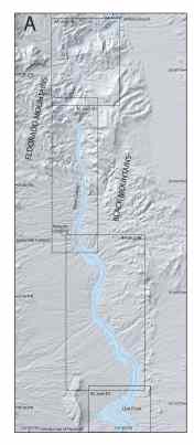
Figure 2. Lake Mohave with survey tracklines (in red), and boxes outlining the extent of Figures 3, 4, 5, and 6. Blue lines are the 550 ft (168 m) and 600 ft (183 m) contours that were digitized off topographic maps of the area.
Click for larger image (PDF version, 8.8 MB).
 |  |  |
![]() To view files in PDF format, download free copy of Adobe Reader.
To view files in PDF format, download free copy of Adobe Reader.
