Surficial Geology and Analysis of post-impoundment sediment of Lake Mohave
Open-File Report 2004-1256
|
Title Page Introduction Methods RESULTS Discussion Conclusion Acknowledgments References |
RESULTSSidescan Sonar Interpretation
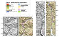
The seven sidescan sonar mosaics in figs. 3a, 3c, figs. 4a, 4c, fig. 5a, figs. 6a, 6c show the relative backscatter intensity of the lake floor. High backscatter appears as white or light gray tones, and weak backscatter is black or dark gray. The mosaic was used to interpret the surficial geology (figs. 3b, 3d, figs. 4b, 4d, fig. 5b, figs. 6b, 6d) based on backscatter intensity and patterns of backscatter. The majority of the surficial units represent pre-impoundment sediments: units that were in place prior to flooding of the reservoir. These units include rock, alluvial, reworked alluvial, flood basin overbank deposits, subaerial dunes, riverbank deposits, and sand waves (small and large). Only the surficial units interpreted to be mass-wasting deposits and areas of low-backscatter on the sidescan imagery may have a post-impoundment origin. The interpretation relied on both pre-dam morphology surveyed by the US Bureau of Reclamation in 1939 and the sidescan imagery. The original maps, scanned and georeferenced by the U.S. Bureau of Reclamation in Boulder City, NV, were made available to us through R. Simms
High-backscatter areas that coincide with steep cliffs on the pre-impoundment topography are interpreted as rock. Some of these areas may be semi-consolidated sediment that has not collapsed due to river undercutting prior to flooding of the area or to water saturation subsequent to the filling of Lake
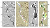
Areas interpreted as alluvial deposits were mapped based on the pre-impoundment topography and where the sidescan sonar imagery commonly shows a fine network of channels on the surface of these deposits. Some of these alluvial deposits extend into the former Colorado River channel and appear to have been reworked. Usually there is a scarp/bank that separates the alluvial deposits from the alluvium that has been reworked by the former river. The alluvial deposits and reworked alluvial deposits appear to be pre-impoundment in origin. Alluvial deposits fringe much of the central part of the lake (fig. 4d and fig. 5b). Riverbanks are steep slopes that show as either high or low-backscatter on the sidescan image depending on the angle of insonofication (fig. 7). The
Pre-impoundment overbank deposits occupy low-lying flat areas on either side of the pre-impounded Colorado River channel along the broadest sections of the original basin. These areas usually possess a low-backscatter signature on
Sand waves, which mostly have wavelengths of 10-30 m, are only found on the floor of the pre-impoundment channel of the Colorado River. They are interpreted to be fluvially generated bedforms that have been inactive since filling of the reservoir. Sand waves mostly occur in areas of moderate backscatter in scattered patches along the length of the lake (fig. 3, fig. 4, fig. 5, fig. 6). Subaerial sand dunes are another type of bedform identified on the sidescan mosaic. These bedforms look much like sand waves except that the wavelength is 30-50 m, and thus they are larger than most of the sand
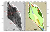
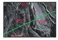
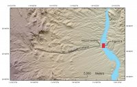
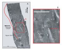
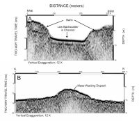
Mass-wasting deposits appear on the sidescan images as high-backscatter areas, which commonly have bright targets in them. Many of these deposits are found off the mouths of washes, and are thought to represent debris-flow deposits associated with floods. Some, however, may just be small alluvial deposits. Other mass-wasting deposits are found along the base of rock cliffs. We are currently comparing the sidescan results with pre-dam aerial photographs that were collected in 1938 to assess the age of these deposits relative to the formation of the lake. One mass-wasting deposit that post-dates the formation of Lake Mohave is located at the mouth of Eldorado Canyon at Nelson's Landing (fig. 8). It is the site of a
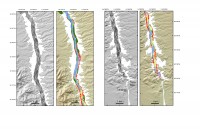
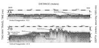
Some low-backscatter areas were identified on the sidescan images that are neither in the pre-impoundment Colorado River bed nor in areas identified as overbank. Low backscatter areas on the channel floor have sidescan intensity values of 1-50. These areas usually occur along the edges of the channel and are often downstream of promontories. These areas are interpreted to represent post-impoundment mud deposits. Moderate backscatter on the channel floor includes areas with sidescan intensity values of 51-179. The backscatter mostly is uniform, and is interpreted to represent sand. Moderate backscatter areas, which occur outside the pre-impoundment riverbed and are free of small channels, appear to be smooth sandy slopes of unknown origin. High backscatter areas on the Colorado River channel have sidescan intensity values between 180-255. In some places the backscatter is uniformly high, smooth, and probably represents gravel beds. In other regions containing high backscatter, the return is more textured and may represent areas of outcrop or widely spread cobbles or boulders. Seismic InterpretationThe high-resolution seismic profiles show that most of Lake Mohave is free of post-impoundment sediment. If sediment has accumulated on the lake floor, it is too thin to be resolved by the Knudsen seismic system. Minimum thickness that can be resolved by this system is approximately 10 cm. The seismic profiles do show that many of the different units that were identified on the sidescan sonar images have different acoustic character in the subsurface as well. The Chirp system did not penetrate in the areas of rock outcrop. Areas of exposed rock are characterized by high amplitude, irregular surface reflection with no subbottom reflections. Hyperbolae from the lake floor are common in the rocky areas, and indicate rough or steep surfaces. Areas mapped as alluvial from the sidescan sonar mosaic have an acoustically prolonged signature on the Chirp profiles (fig. 10a). This signature is due presumably to there being no consistent internal reflections within these unconsolidated deposits.
The main channel of the pre-impoundment Colorado River is well preserved in the Chirp profiles, and there is no evidence of post-impoundment sediment cover (fig. 10b). The riverbanks can have several meters of relief and are slightly elevated (levee deposit) relative to the surrounding overbank deposits. Within the main channel, there often is a strong and continuous reflector that represents the maximum fluvial down cutting or channel-lag deposit (fig. 10b). Above the channel lag, fluvial-channel fill or bar deposits appear as acoustically homogeneous units (fig. 10b). These bar deposits appear as large asymmetrical sand
Overbank deposits of the pre-impoundment Colorado River are also clearly observed in the Chirp profiles and their extent coincides with overbank deposits mapped from the sidescan sonar imagery. Frequently, a strong and moderately continuous reflector is seen on the chirp profiles in these areas (figs. 10a, 10c). Secondary fluvial channels (tens of meter across) have reworked this surface as well as the overlying overbank unit. One such channel seen at the present lake floor (figs. 7, 10a) has not been filled and was probably active as the river valley was impounded. The Chirp profiles show well-preserved sand dunes that coincide with sand dune areas on the sidescan sonar mosaic. The dunes are located adjacent to but outside the main river channel and are commonly surrounded by overbank deposits. The dunes have amplitudes up to 4.5 m and wavelengths are mostly less than 60 m. The asymmetry of the dunes suggests a northeastward (upstream) transport direction. Their location and asymmetry suggest an eolian origin.
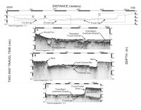
Although, areas of low backscatter on the sidescan mosaic suggest possible areas of post-impoundment deposition, the Chirp profiles do not indicate significant thickness of sediment in these areas. Typically, there is no indication of sediment overlying a highly reflective pre-impoundment surface (the sediment thickness is below the vertical resolution limit of the Chirp system) except for a few areas where the thickness is about a meter or less (fig. 12a). At the mouths of some washes, the lake floor is covered by mass-wasting deposits (fig. 3, fig. 4, fig. 5, fig. 6) derived from flash floods entering the lake. Nelson's Landing, at the mouth of Eldorado Canyon (fig. 8), is one such place where a flash flood has been documented (Glancy and Harmsen, 1975), and the sidescan imagery shows the deposit on the lake floor that resulted from this flash flood (fig. 9). A Chirp profile across the mouth of Eldorado Canyon shows that this unit is mounded and reaches about 3-m in thickness (fig. 12b). |