Surficial Geology and Analysis of post-impoundment sediment of Lake Mohave
Open-File Report 2004-1256
|
Title Page INTRODUCTION Methods Results Discussion Conclusion Acknowledgments References |
INTRODUCTIONPurpose
Lake Mohave is one of several multi-purpose reservoirs that have been constructed on the Colorado River. The lake was formed upon completion of the Davis Dam in 1953. Since then, research on this reservoir has dealt primarily with vegetation surrounding the lake (Tallent-Halsell and Walker, 2002), fish (Bozek and others, 1990), water quality (Paulson and Baker, 1983), and geological hazards to recreation areas surrounding the lake associated with flash floods (Glancy and Harmsen, 1975; Moosburner, 1979; 1981). Because no lake-floor mapping had been conducted since completion of the Davis Dam, the U.S. Geological Survey, in cooperation with researchers from the University of Nevada Las Vegas, completed a geophysical survey of this lake in April 2002. The survey included collection of sidescan sonar imagery of nearly the entire lake floor, and of high-resolution seismic-reflection profiles along widely spaced lines throughout the lake. These acoustic data were used to produce detailed maps of the lake floor, which were subsequently used to determine the amount of sediment that had accumulated in the lake since impoundment, its distribution, and the processes of deposition. Information on sedimentation in the reservoir is needed for several reasons: Setting
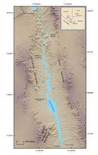
Lake Mohave is a reservoir that originated with the impoundment of the Colorado River in 1953 after construction of Davis Dam. In this region, the Colorado River Valley lies between the Black Mountains to the east, in northwestern Arizona, and the Eldorado and Newberry Mountains to the west, in southern Nevada (fig. 1). From north to south, Lake Mohave extends approximately 100 km, along this valley, from south of Hoover Dam to Davis Dam. The northern section of the reservoir is constrained by the steep rock walls of Black Canyon (fig. 2) for a length of 36 km and is narrower than 100 m in places. South of Black Canyon, Lake Mohave gradually widens to as much as 2 km. Primarily alluvial deposits bound this section of the lake. The upper strata of the alluvial deposits consist of unconsolidated gravel and the lower portions of cemented gravel. The Colorado River and tributary washes have incised and cut through the alluvium into consolidated deposits (Longwell, 1963). As a result, the shoreline of this portion of Lake Mohave is characterized by numerous coves where tributary washes enter the lake. To the south, for a length of approximately 1 km, Lake Mohave narrows to less than 500 m in Painted Canyon (fig. 2), an area of a local protrusion of volcanic rock (Longwell, 1963). The lake widens again to the south and reaches a maximum width of 5.8 km where the lake lies within a more gently sloping alluvial basin that is approximately 20 km wide. Lake Mohave is constricted south of this location with increasing slope of the alluvial basin and is bounded by the steep slopes of the Newberry Mountains to the west and alluvium to the east. Lake Mohave terminates in the south where Davis Dam was built within a narrow gorge cut into Precambrian igneous rock (Longwell, 1963). |