Introduction
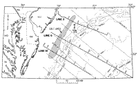
We investigate a nearly horizontal lens, deposited in the late Toarcian or early Aalenian (189-187 Ma), during the transition from synrift to postrift development of the Baltimore Canyon Trough. The lens is imaged as a continuous layer of varying thickness over an area of approximately 7500 km², lying landward of the East Coast magnetic anomaly (ECMA) and the Jurassic shelf-edge complex (Figure 1). The moderately deep reflection associated with the lens' upper surface at 5-6 s two-way traveltime, can be traced laterally for a distance of 25 km and consistently maintains an anomalously high amplitude and negative polarity (Figure 2).
A low-impedance layer at this depth could be salt, gas-bearing sediments, overpressured shale, or a weathered igneous intrusion. Grow (1980) suggested that the unit originated from salt diapirism that was triggered by the formation of the Schlee dome mafic pluton (See Figure 2A, Line 2, SP 3400 for location). Lawrence and others (1990), interpreted the sequence as an aggradational carbonate and evaporite complex. The interpretation of this layer is important because its genesis has bearing on the early evolution of the Baltimore Canyon Trough. If it resulted from an intrusive event, it is indicative of volcanic activity, possibly a continuation of the rifting events occurring later and more pervasively than previously thought. If the layer is composed of gas-charged sediments, then it would have economic importance. The salt alternative is of interest both with respect to its lithology and with respect to whether it is authigenic. If it is a horizontal salt deposit, then the question arises as to why it did not flow within this basin; salt mobilized extensively in the basins to the north and south into diapirs seaward of the present shelf, and salt formed many diapirs in the Gulf of Mexico.
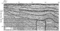 | | Figure 2A. Line 2. Interpreted, amplitude-modulated display of wavelet-processed multichannel reflection data. Click on figure for larger image. |
|
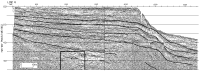 | | Figure 2B. Line 6. Interpreted, amplitude-modulated display of wavelet-processed multichannel reflection data.
Click on figure for larger image. |
|
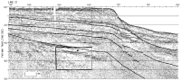 | | Figure 2C. Line 10. Interpreted, amplitude-modulated display of wavelet-processed multichannel reflection data. Click on figure for larger image. |
|
Salt deposits are commonly associated with the formation of continental margins, as they accumulated in the hypersaline environment that often existed during the rifting and early extensional phases of new ocean basin formation. Some of the best studied examples are the Jurassic Louann Salt of the Gulf of Mexico (Martin, 1980; Buffler, 1989; West, 1989; Wu and others, 1990a, b), the evaporites of the Late Triassic Osprey Formation and salt of the Early Jurassic Argo Formation offshore eastern Canada (Emery and Uchupi, 1972; Jansa and Wade, 1975; Uchupi and Austin, 1979; Jansa and others, 1980; Jansa, 1986), the extensive Red Sea deposits (Gaulier and others, 1988, Guennoc and others, 1988,1990; Miller and Barakat, 1988) and the North Atlantic deposits (Grow, 1980; Dillon and others, 1982; Holser and others, 1988).
The geometry of the lens does not rule out the alternate lithologies. Thus, we have further constrained the interpretation of the lens' composition by detailed mapping and by analysis of seismic properties. We analyze the reflector in three seismic lines using general linear inversion methods, including amplitude versus offset analysis, where amplitude measurements are used to quantitatively estimate lithologies. Also, we present one-dimensional seismic models to further constrain the geophysical characteristics and interpretations.
|