
Digital Mapping Techniques '04— Workshop Proceedings
U.S. Geological Survey Open-File Report 2004–1451
The National Geologic Map Database Project: Overview and Progress
1U.S. Geological Survey, 926-A National Center,
Reston, VA 20192; Telephone: (703) 648-6907; Fax: (703) 648-6977; e-mail: drsoller@usgs.gov;nstamm@usgs.gov
2Ohio Geological Survey, 2045 Morse Rd., Bldg. C–1, Columbus, OH 43229-6693; Telephone: (614) 265-6988; Fax: (614) 268-3669; e-mail: thomas.berg@dnr.state.oh.us
The National Geologic Map Database (NGMDB) project continues to fulfill its mandate1. Some of its accomplishments are specific and tangible, and others are more general in nature—for example, the NGMDB contributes to advancements in digital mapping techniques and database design by agencies in the United States and internationally. However, without extensive collaboration from highly skilled and enthusiastic members of the state geological surveys and the Geological Survey of Canada, these accomplishments would not have been possible. Highlights of the past year include:
INTRODUCTION
This project provides an unusual if not unique opportunity to foster better relations and technical collaboration among all geological surveys in the nation. Given the nature of the issue—the creation and management of geoscience map information in digital format during a period of rapid technological evolution—collaboration is critically important. Perhaps more significant, these are changing times for all geological surveys—funding and staff seem to become more scarce each year—and through collaboration we can share our intellectual and computing resources and not “reinvent the wheel” within each agency.
Before describing the NGMDB components and progress, we wish to highlight the various mechanisms by which we define and accomplish our goals. Because advice, guidance, and technical collaboration are an integral part of this project, we discuss the project plan at numerous venues throughout the year. These include geoscience and related professional society meetings, the Digital Mapping Techniques workshop, and site visits to state geological surveys. Advice gathered at these venues serves to refine and, in some cases, to redirect the project’s goals. Comments from users, generally via our Web feedback form, also provide us with valuable perspectives, and have prompted us to make numerous modifications, especially to our Web interface design.
Because the NGMDB’s scope is so broad, its success relies on the many people and agencies that participate in its activities. Members of the committees and small working groups that advise and contribute to the project’s goals are listed in Appendix A. These committees are an important mechanism for coordinating with each agency, and they deserve noting:
BACKGROUND
The National Geologic Mapping Act of 1992 and its reauthorizations in 1997 and 1999 (PL106–148) require a National Geologic Map Database to be built by the USGS in cooperation with the AASG. This database is intended to serve as a “national archive” of standardized geoscience information for addressing societal issues and improving our base of scientific knowledge. The Mapping Act anticipates a broad spectrum of users including private citizens, professional geologists, engineers, land-use planners, and government officials. The Act requires the NGMDB to include these geoscience themes: geology, geophysics, geochemistry, paleontology, and geochronology.
In mid-1995, the general stipulations in the Geologic Mapping Act were addressed in the proposed NGMDB design and implementation plan developed by the USGS and AASG. Summaries of this plan are listed in Appendix B. Because of the mandate’s broad scope, we proposed a phased, incremental design for the NGMDB. A phased approach has two benefits: 1) it enables us to identify the nature and quality of existing information and quickly serve it to the public; and 2) it gives us time to build consensus and expertise among the database designers in the state geological surveys and the USGS. Furthermore, it enables us to more effectively consider and respond to evolving technology and user needs. These phases, and our progress, are shown in Figure 1.
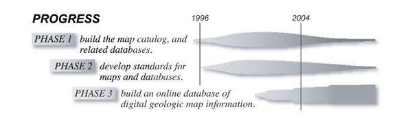 |
Figure 1. Diagram showing the three NGMDB
Phases, and progress toward our goals (for example, documenting in the
Geoscience Map Catalog all maps and related products for the United States
and its territories and possessions). |
In the first and most fundamental phase of the project, we are building a set of easy-to-use reference databases; for example, a comprehensive, searchable map catalog of all geoscience maps in the United States, whether in paper or digital format. The second phase of the project focuses on the development of standards and guidelines needed to improve the utility of digital maps. The third phase proposes to, in the long term, develop an online database of (mostly vector-based) geologic map information at various scales and resolution.
In late 1995, work began on Phase One. The formation in mid-1996 of several AASG/USGS Standards Working Groups initiated work on Phase Two. The project opened its Web site to the public in January 1997, as a prototype intended to solicit comments on the Map Catalog. At the Digital Mapping Techniques ’98 through ’04 workshops, a series of presentations and discussion sessions provided updates on the NGMDB and, specifically, on the activities of the Standards Working Groups (see Appendix B). This report summarizes accomplishments since the project’s inception, and therefore repeats material from previous reports, but it focuses on activities since mid-2003. Additional and more current information may be found at the NGMDB project-information Web site, http://ngmdb.usgs.gov/info/. The searchable databases are available at http://ngmdb.usgs.gov/. To submit general comments about project scope and direction, please address the authors directly. For technical comments on the databases or Web page design, please use our Web feedback form; this form is linked from many of our search pages (see “Your comments are welcome”, at http://ngmdb.usgs.gov/).
PHASE ONE
Through ongoing discussions with private companies, citizens, government officials, and research geologists, it is clear that first and foremost, we need to provide reference databases so that geoscience maps and descriptive information can be found and used. Many people want to better understand the geologic framework beneath their home, business, or town, and so we are building several databases that support general, “data-discovery” questions posed by citizens and researchers alike. These reference databases are: 1) the Geoscience Map Catalog and its extension, the Geologic Map Image Library; 2) GEOLEX, the U.S. geologic names lexicon; and 3) Geologic Mapping in Progress, which provides information for ongoing National Cooperative Geologic Mapping Program (NCGMP) mapping projects, prior to inclusion of their products in the Map Catalog. Plans for the National Paleontology Database also are discussed below.
Figure 2 shows the number of people (actually, the number of unique IP addresses or computers) who have used the NGMDB, per month since it opened to the public in January 1997. These numbers indicate that the site has become a useful resource. Additional increases in use are expected as the Map Catalog, GEOLEX, and Image Library become fully populated.
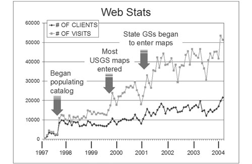 |
Figure
2. Web usage for the
Geoscience Map Catalog, GEOLEX, Image Library, and Mapping in Progress
Databases. This diagram shows that the number of people (actually, the
number of unique IP addresses or computers) using the NGMDB has gradually
increased as these resource databases become more widely known; this usage
trend is punctuated by sharp increases after essentially all USGS maps
were entered into the Catalog and after many state geological surveys began
to enter map records. The Catalog accounts for the majority of user visits
to the NGMDB site. |
The Geoscience Map Catalog and Image Library
“I want to know if a map exists for an area, and where I can get a copy
of it…”
“I want to see a picture of this geologic map, online…”
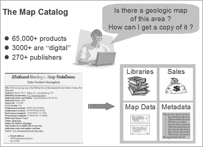
Many organizations produce paper and digital geoscience maps and related products. Discovering whether a product exists for an area, and if so, where it can be purchased or obtained online, can be a time-consuming process. In the past, people found this information by contacting various agencies and institutions, and by conducting extensive library searches. To increase accessibility and use of these paper and digital products, we built the Geoscience Map Catalog as a comprehensive, searchable database of all maps and related products for the United States and its territories and possessions.
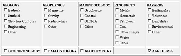
The Geoscience Map Catalog contains bibliographic records for more than 65,000 products from about 270 publishers (see our most current list of publishers at http://ngmdb.usgs.gov/ngmdb/pub_series.html). Most of these products are from the USGS and from 45 state geological surveys. Other publishers include state agencies, federal agencies, scientific societies, park associations, universities, and private companies. Products range from digital maps to books that don’t contain maps but describe the geology of an area, and can be formal series products, open-file reports, or unpublished dissertations (Figure 3). Because there are many types of geoscience maps and related products, we categorize them by theme (Figure 4).
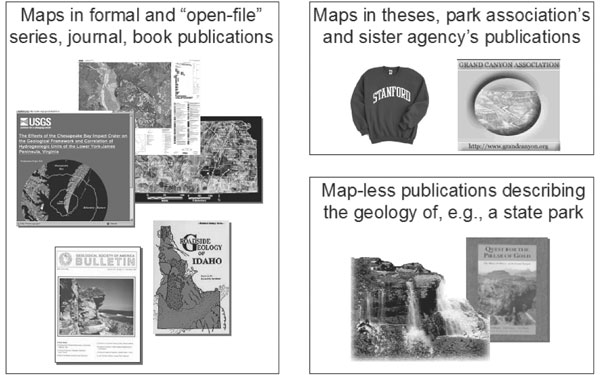 |
Figure
3. Bibliographic records
in the Geoscience Map Catalog are drawn from a diverse group of more than
320 publishers. |
 |
Figure
4. A portion of the
Geoscience Map Catalog search page, showing the types of products included. |
The Geoscience Map Catalog provides links to more than 3000 published, downloadable products of the USGS and the state geological surveys. These links are established only to stable Web pages that provide the official copy-of-record for the publication—in the USGS, links are established only to the Publications Server and the NSDI Clearinghouse node.
The Geoscience Map Catalog identifies products that meet the user’s search criteria, and provides links to the downloadable data and metadata, to a depository library, or to the appropriate organization for information about how to purchase the product (Figure 5). We address the diverse needs of our user audience through four search options. The easy-to-use Place Name Search is based on the USGS Geographic Names Information System (GNIS); it is designed mostly to address the needs of non-geologists who want to use a simple interface to find information about their home, town, or worksite. In contrast, other choices such as the Comprehensive Search offer more search criteria.
 |
Figure
5. Interested in knowing
something about the geology of an area (such as the land beneath their
house), the user queries the Geoscience Map Catalog, which returns a hit
list of possibly useful maps and related products. The user selects one
of these and, from the Product Description Page (shown on left side of
figure), obtains further information and can then choose to buy the product,
view and download it, inspect the metadata, or find it at a depository
library. |
Through discussions with users, and from comments received via our Web feedback form, it became clear that many people are interested in viewing and/or obtaining maps “online.” Interpretation of the phrase “providing maps online” varies widely—to some people, it implies access to fully attributed, vector-based map databases, whereas to other people, it implies access to map images. Regarding the vector-based map database, we address this large task in Phase Three, below. Regarding access to map images, we have begun to provide these to users via our Geologic Map Image Library (Soller and Berg, 2003a).
The Image Library contains high-resolution (300 dpi) images that are compressed into MrSID format and served to the user via a standard Web browser. These MrSID-compressed images are easily and quickly viewed in detail, and in most cases can be downloaded. Upon request, we also provide access to the source image file, in non-georeferenced TIFF format. The Image Library is a relatively new initiative, and its search interface and design are still under development. We anticipate that in the near future it will become more fully integrated with the Geoscience Map Catalog because: 1) the Image Library’s database is based on a subset of the Map Catalog’s bibliographic database, and 2) an integrated search of bibliographic information and images will benefit our users.
The U.S. Geologic Names Lexicon
(“GEOLEX”)
“I want to know more about the geologic units shown on this map…”
This is the nation’s lexicon of geologic nomenclature. GEOLEX contains information for more than 16,000 geologic units in the U.S. (Stamm and others, 2000). It is an excellent resource for finding significant publications that defined and described geologic units mapped in the U.S. These publications can be critically important in field studies, enabling students and mappers to compare these published descriptions with what they see in the field.
GEOLEX includes the content of the four geologic names databases on USGS Digital Data Series DDS-6 (Mac Lachlan and others, 1996). Before incorporating into GEOLEX, those databases were consolidated, revised, and error-corrected. Our work continues to focus on:Many state geological surveys have been registering new geologic names with the USGS for decades, and are encouraged to continue this practice. In order to promote standardized geologic nomenclature within the U.S., we are petitioning the USGS to re-establish the GNC. Formerly a committee that focused on nomenclature issues within the USGS, we propose that the new GNC should include members from each state geological survey. When a conflict arises, GNC members from the USGS and those states affected will resolve it, and any changes will be recorded in GEOLEX. Through this mechanism, we anticipate that GEOLEX will serve the entire U.S. geoscience community.
Geologic Mapping in Progress Database
“I see from the Map Catalog that a map hasn’t been published for this
area—is anyone mapping there now?”
Our Geologic Mapping in Progress Database provides users with information about current mapping activities (mostly at 1:24,000- and 1:100,000-scale, but at 1:63,360- and 1:250,000-scale in Alaska) that is funded by the National Cooperative Geologic Mapping Program. In 2005 we will be re-engineering and repopulating this database.
Paleontology Database
“I want to know if there is any fossil data from this area…”
The NGMDB project has designed, and is planning to develop, a National Paleontology Database (see Wardlaw and others, 2001). As originally envisioned, we would build prototypes of this database in areas where geologic mapping is underway, so that we could work with mapping projects to design a National database useful to science as well as to the public. Plans for a prototype have been delayed somewhat, in order to assess what can be accomplished with funding and personnel resources more modest than earlier anticipated. We now envision a system that: 1) includes new data provided by the NGMDB, and 2) archives and serves modestly-sized databases that have already been developed by USGS and other scientists.
PHASE TWO
Phase Two focuses on development of standards and guidelines needed to assist the USGS and state geological surveys in efficiently producing digital geologic maps, in a more standardized and common format. Our profession encourages innovation and individual pursuit of science, and so the question may be posed—why do we need these standards? Clearly, standards should not impede science but instead should help us efficiently communicate our science to the public. The need for communication was perhaps best articulated by former USGS Director John Wesley Powell, while planning for the new Geologic Atlas of the United States:
“… the maps are designed not so much for the specialist as for the people, who justly look to the official geologist for a classification, nomenclature, and system of convention so simple and expressive as to render his work immediately [understandable]…” (Powell, 1888).
At that time, and throughout the early 20th century, Powell and others guided the USGS and the Nation’s geoscientists toward a set of robust, practical standards for classifying geologic units and materials and representing them on maps. Those standards endured and evolved, and continue as basic guidelines for geologic mapping. Although today we commonly record in the field and laboratory far more complex information than during Powell’s era, the necessity to provide it to the public in a standardized format remains unchanged. Newly evolving data formats and display techniques made feasible by computerization challenge us to revisit Powell’s vision, and to develop standards and guidelines appropriate to today’s technology and science.
In mid-1996, the NGMDB project and the AASG convened a meeting to identify the types of standards and guidelines that would improve the quality and utility of digital maps produced by the nation’s geological surveys. From that meeting, Standards Working Groups were formed to address: 1) standard symbolization on geologic maps; 2) standard procedures for creating digital maps; 3) guidelines for publishing digital geologic maps; 4) documentation of methods and information via formal metadata; and 5) standard data structures and science terminology for geologic databases. The working group results will help provide a set of national standards to support public use of standard, seamless geologic map information for the entire country. In essence, Powell’s pragmatic vision for the Geologic Atlas of the U.S. has been applied a century later to the National Geologic Map Database.
The tasks assigned to these Standards Working Groups are interrelated, as shown in Figure 6—when in the field, a geologist makes observations and (often, provisionally) draws geologic features on a base map; at that time, the accuracy with which these features are located on the map can be estimated. Further, the information may be recorded digitally in the field; if so, it can be structured similar to, or compatible with, the map database’s structure (the “data model” in this figure). Returning to the office, the geologist commonly organizes and interprets field observations and prepares for map production—descriptions may be standardized according to an agency or project-level terminology or “science language,” the map data may be structured according to the standard data model implemented by the agency, and procedures may be documented with metadata both in the office and when gathering data in the field. The descriptive information then is combined with the feature location information in a GIS, and digital cartography is applied to create a map that is published according to agency policies. Finally, the map is released to the public and accessed through various mechanisms including the NGMDB.
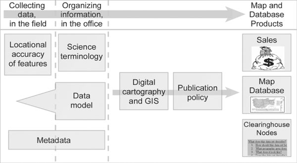 |
Figure
6. Diagram showing
how the standards and guidelines under development by the NGMDB and related
groups relate to the process of creating and publishing a map and database. |
As described below, since 1996 these Working Groups and their successor organizations have made significant progress toward developing some of the necessary standards and guidelines. General information about the Working Groups and details of their activities are available at http://ngmdb.usgs.gov/info/standards/. Working Group members are listed in Appendix A.
Internationally, the NGMDB participates in venues that help to develop and refine the U.S. standards. These venues also bring our work to the international community, thereby promoting greater standardization with other countries. Examples include:
Geologic Map Symbolization
A draft standard for geologic map line and point symbology and map patterns and colors, published in a USGS open-file report in 1995, was reviewed in 1996 by the AASG, USGS, and Federal Geographic Data Committee (FGDC). It was revised by the NGMDB project team and members of the USGS Western Region Publications Group, and in late 1997 was circulated for internal review. The revised draft then was prepared as a proposed federal standard, for consideration by the FGDC. The draft was, in late 1999 through early 2000, considered and approved for public review by the FGDC and its Geologic Data Subcommittee. The document was released for public comment within the period May 19 through September 15, 2000 (see http://ngmdb.usgs.gov/fgdc_gds/mapsymb/ for the document and for information about the review process). This draft standard is described in some detail in Soller and Lindquist (2000). Based on public review comments, in 2002 a new section was added to the draft standard to address uncertainty in locational accuracy of map features. This section was presented for comment (Soller and others, 2002) and revised accordingly. With assistance from a Standing Committee to oversee resolution of review comments and long-term maintenance of the standard, the document is being prepared for submittal to FGDC, for final discussion and adoption as a Federal standard. This process is expected to conclude in 2005. Thereafter, the NGMDB with assistance from the Standing Committee will maintain and, as needed, update the standard.
Digital Mapping
The Data Capture Working Group has coordinated eight annual “Digital Mapping Techniques” (DMT) workshops for state, federal, and Canadian geologists, cartographers, managers, and industry partners. These informal meetings serve as a forum for discussion and information-sharing, and have been quite successful. They have significantly helped the geoscience community converge on more standardized approaches for digital mapping and GIS analysis, and thus agencies have adopted new, more efficient techniques for digital map preparation, analysis, and production. In support of DMT workshops, an email listserver is maintained to facilitate the exchange of specific technical information.
The most recent DMT workshop, held in Portland, Oregon, and hosted by the Oregon Department of Geology and Mineral Industries, was attended by about 100 representatives of 40 state, federal, and Canadian agencies and private companies. Workshop Proceedings are published in paper format and online (see Appendix B and http://ngmdb.usgs.gov/info/dmt/). The website also provides: 1) a search mechanism for all Proceedings, by author, title, affiliation, and topic; and 2) downloadable presentations and posters from recent Proceedings. Copies of the printed Proceedings may be obtained from David Soller or Thomas Berg.
Map Publication Requirements
Through the USGS Geologic Division Information Council, the NGMDB led development of the USGS policy “Publication Requirements for Digital Map Products” (enacted May 24, 1999; see link under Map Publication Guidelines, at http://ngmdb.usgs.gov/info/standards/). A less USGS-specific version of this document was developed by the Data Information Exchange Working Group and presented for technical review at a special session of the Digital Mapping Techniques ’99 workshop (Soller and others, 1999). The revised document (entitled “Proposed Guidelines for Inclusion of Digital Map Products in the National Geologic Map Database”) was reviewed by the AASG Digital Geologic Mapping Committee. In 2002, it was unanimously approved via an AASG resolution, and has been incorporated as a guideline for digital map product deliverables to the STATEMAP component of the National Cooperative Geologic Mapping Program (see link under Map Publication Guidelines, at http://ngmdb.usgs.gov/info/standards/). The guideline also is recommended for participants in the Program’s EDMAP component, which provides funding to university students to conduct geologic mapping.
Among the geological surveys there are many approaches to determining authorship credit and citation format for geologic maps, digital geologic maps, and associated digital databases. It is prudent for agencies to adopt policies that preserve the relationship of the geologist-authors to their product (the map image) and to identify the appropriate authorship (if any) and/or credit for persons responsible for creating the database files. A summary of this issue and a proposed guideline was outlined and discussed at the Digital Mapping Techniques workshop in 2001 (Berquist and Soller, 2001). This guideline stresses the importance of providing the suggested citation with each publication, and has proven useful to geological surveys as they attempt to balance responsibility and credit among field geologists, GIS specialists, and cartographers involved in creating a geologic map and database.
Metadata
The Metadata Working Group developed its final report in 1998. The report provides guidance on the creation and management of well-structured formal metadata for digital maps (see http:// ngmdb.usgs.gov/info/standards/metadata/metaWG.html). The report contains links to metadata-creation tools and general discussions of metadata concepts (see, for example, the metadata-creation tools, “Metadata in Plain Language,” and other helpful information at http://geology.usgs.gov/tools/metadata/.
Geologic Map Data Model
In early 1999, with informal release of a draft version of a data model (Johnson and others, 1998), the Data Model Working Group had concluded its work. The Group then was succeeded by the North American Geologic Map Data Model Steering Committee (NADMSC, http://nadm-geo.org/, Figure 7). The NGMDB evaluated the draft data model, and developed in a prototype, object-relational database environment a data model that more effectively managed the geologic map information (Soller and others, 2002). This prototype was conducted in cooperation with the Kentucky Geological Survey, the Geological Survey of Canada, and the University of California–Santa Barbara.
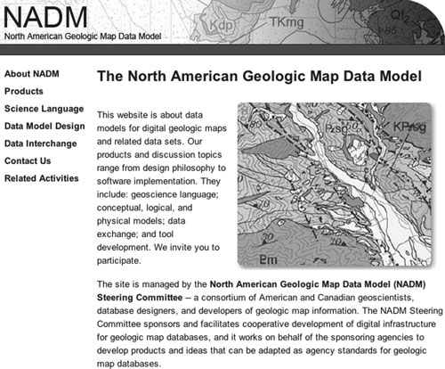 |
Figure
7. Website of the
North American Geologic Map Data Model Steering Committee. |
Several prototypes, including the NGMDB (see “variants and implementations” at http://nadm-geo.org/dmdt/), provided the basis for the NADMSC to continue to refine its ideas. In 2004, this work produced a significant accomplishment—a conceptual data model known as NADM C1 (NADM, 2004); this model was published simultaneously by the USGS and GSC, and is available at http://pubs.usgs.gov/of/2004/1334/. State and USGS collaborators on the NGMDB continue to participate in the NADMSC, helping to further develop, refine, and test the NADM C1 and the standard science language that accompanies it. Information about NADMSC activities is provided in two papers in this volume: 1) the development of a GML-based interchange format (see Boisvert and others); and 2) the development of standard science language to describe the lithology of earth materials (see NADM SLTT).
The NGMDB also is involved with the vendor community, for example through discussions with ESRI regarding their interest in defining an ArcGIS template or data model for geology, similar in concept to templates that ESRI has defined for other business sectors (see “geology” and other links at http://support.esri.com/index.cfm?fa=downloads.dataModels.gateway). We will continue to discuss this issue with ESRI, as we develop a database of map information for the NGMDB, (see discussion under “Phase Three”, below).
The NGMDB also contributes to development of international standards that will promote the management and interchange of geoscience information. This work is conducted under the aegis of the International Union of Geological Sciences’ Commission for the Management and Application of Geoscience Information (“IUGS CGI”; http://www.iugs.org/iugs/science/sci-cnfo.htm), specifically under its Data Model Collaboration Working Group (http://www.bgs.ac.uk/cgi_web/tech_collaboration/data_model/data_model.html). The NGMDB, and U.S. agencies in general, are benefiting significantly from this collaborative effort because:
PHASE THREE
Over the past few decades, significant advances in computer technology have begun to permit complex spatial information (especially vector-based) to be stored, managed, and analyzed for use by a growing number of geoscientists. At the beginning of the NGMDB project, we judged that computer-based mapping was not a sufficiently mature discipline to permit us to develop an online map database that addressed the scope mandated by the National Geologic Mapping Act. In particular, technology for display and query of complex spatial information on the Web was in its infancy, and hence was not seriously considered by the NGMDB project as a viable means to deliver information to the general public. However, there now exists: 1) sufficient digital geologic map data; 2) sufficient convergence on standard data formats, data models, GIS and digital cartographic practices and field data capture techniques; and 3) sufficient technological advances in Internet delivery of spatial information to warrant a research effort for a prototype, online map database.
Before beginning to design this database, project personnel held numerous discussions with geoscientists and the general public to gauge interest in an online database and to define its scope. Based on these discussions, it was clear that this database should be:
This map database will integrate with other databases developed under the NGMDB project. For example, a user accessing the online map database might identify a map unit of interest, and then want to purchase or download the original published map product, or inquire about fossils found within that unit, or learn about the history of the geologic unit. Also, a user might access the Map Catalog and identify a map of interest, and then be linked to the online map database in order to browse and query it.
Prototyping
The NGMDB project has begun a series of prototypes, to advance our understanding of the technical and management challenges to developing the operational system; an introduction is given in Soller and others (2000). In 1999, we outlined some basic requirements for the prototype and tested them using map data for the greater Yellowstone area of Wyoming and Montana (Wahl and others, 2000). The second prototype (Soller and others, 2001) was conducted in cooperation with the Kentucky Geological Survey. In that prototype, we demonstrated in a commercial database system (GE-Smallworld; http://www.gepower.com/prod_serv/products/gis_software/en/smallworld4.htm) how the geologic database could be analyzed over the Web in concert with local datasets. The data model for the second prototype is described in Soller and others (2002), and was a significant contributor to the design of the new NADM Conceptual Data Model noted above.
Before proceeding further with plans for the online map database, we need to define a set of standardized terminology for the properties of earth materials (the “science language”). This must be sufficiently robust to accommodate terminology generated through today’s field mapping, and terminology found in map unit descriptions on older and on smaller-scale maps, where descriptions tend to be highly generalized. In our current prototype we are creating richly-attributed map data with a standardized data model and science terminology, using existing and new mapping in disparate field areas (for example, central Arizona, northern Virginia, Kentucky, and southern California). To achieve this, we have invested significantly in development of a data-entry software tool supported by science terminology derived from the NADMSC (see report by the NADM SLTT, in these Proceedings).
The data-entry tool is being designed as a stand-alone application that will connect to a relational database that implements the NGMDB design (see Richard and others, this volume). The tool will support: 1) development and editing of science vocabularies required by the NGMDB database implementation; 2) construction of formal descriptions for geologic units, earth materials, and geologic structure; and 3) the construction and editing of metadata to document the source and processing history of data. Because the NGMDB is envisioned as a distributed information system, with a variety of state and federal entities responsible for maintaining distinct bodies of data or repositories, the data-entry tool will include provisions for establishing data ownership and for maintaining access control based on user permissions for different repositories. Our priorities are to: 1) increase the number of science vocabularies developed or endorsed by the NGMDB and available through the data-entry tool; 2) develop an import and export functionality using the NADM GML interchange format; and 3) create an effective user interface. We anticipate that this tool will be available in 2005 for our cooperators to evaluate and use.
What is a data model, and how does it apply to geologic maps?
A data model provides organization to the descriptive and spatial information that constitute a geologic map. The relations between a data model, science terminology, and the geologic map require some explanation. A data model may be highly conceptual, or it may describe the data structure for managing information within a specific hardware/software platform. In either case, it is a central construct because it addresses the database design for geologic maps in GIS format. In Figure 8, the data model is simplified to four locations, or “bins”, where information can be stored, with each bin containing many database tables and fields:
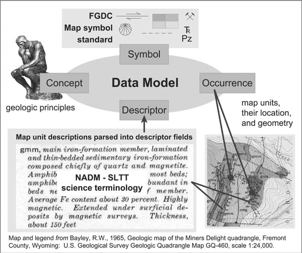 |
Figure 8. Simplified representation of the data model and its application to a typical, 2-D geologic map. The presence of a geologic unit on the map, referred to in the data model as an “occurrence” of that map unit, is described by: 1) its bounding contacts and faults, whose coordinates are stored as the unit’s “geometry”; and 2) its physical properties, which are stored as the unit’s descriptors. |
Will the U.S. have a single standard data model and science terminology?
The NGMDB online map database is envisioned as a distributed system that will provide seamless access to, and display of, map data served by many agencies. To achieve this vision, significant funding and time will be required. If all agencies used the same science terminology and exactly the same data model, and if it were implemented on the same hardware and software platform, building a functional system would be relatively straightforward. That, however, is not a realistic scenario. Each agency has a unique history, set of objectives, and budget that will dictate the nature of their map database. (It should be noted that not every geological surveys in the U.S. can even afford to build such a system.) A more realistic approach is to assume a heterogenous computing environment, and to build software that can translate data structure and science terminology from one agency’s system to another. This translation mechanism ensures “interoperability” between systems, and is the most realistic approach for the NGMDB. A prototype system developed by the U.S. GEON project (funded by the National Science Foundation) was discussed at DMT’03 (Ludascher and others, 2003).
To facilitate interoperability among systems, the NGMDB will define and maintain a set of reference standards (for data model, science terminology, geologic time scale) based in part on those produced by the NADMSC. Interoperability software that enables disparate systems to appear to the user as a single system is now being evaluated by groups including the NADMSC, NGMDB, GEON, and the IUGS’s CGI. Through this technology, agencies should be able to correlate their unique data structure and scientific terminology to the reference standard, and translators (presumably GML-based) should enable us to display the information to the user in a single view.
Extending the data model to include three-dimensional (3-D) map information
The NADM C1 data model was designed for the typical geologic map, which provides a two-dimensional representation of the geologic framework. On most geologic maps, this framework is expressed generally, in cross-sections and map unit descriptions. The NGMDB project is exploring methods for incorporating a more complete depiction of geologic information in three dimensions, especially in raster (and voxel) format (Soller and Berg, 2003). This 3-D information will be managed in the data model, which will require extensions to NADM.
National and regional map coverage
The online map database will be more useful if it includes some geologic map coverage for the entire nation. To that end, the NGMDB has supported compilation and GIS development of several regional maps. Most significant is the digital version of the “Geologic Map of North America”. This map is the final product of the Geological Society of America’s (GSA) Decade of North American Geology project. We provided funding and expertise for development of the digital files that will be used to print the map, in order to engage GSA in a plan to develop a database for the map. When compilation and review of the map has been completed, and the map printed in early 2005, we will propose a database design and begin to populate the digital files made available from cartographic production of the map. This work will be conducted in collaboration with GSA and interested national geological surveys.
OUTREACH TO LATIN AMERICAN GEOLOGICAL SURVEYS
We regularly meet with colleagues from other geological surveys, and especially with other Federal surveys in which similar work is being planned or conducted. The purpose of these meetings is to share information and to improve the design and quality of the databases and standards under development within the NGMDB and other agencies. To most geoscientists, the terminology and concepts of Information Technology and database design are relatively new and unfamiliar. Therefore, it can be especially difficult to convey the subtle meaning of these technical terms and concepts to colleagues who speak different languages. In an attempt to improve our communication with neighboring countries, the NGMDB project worked with the USGS/University of Arizona’s Earth Surface Processes Research Institute (ESPRI), the University of Arizona’s National Center for Interpretation, and the City of Tucson public schools to translate several reports from English to Spanish. The translated reports and a summary of the Spanish translation project are posted to http://ngmdb.usgs.gov/Info/reports/reports-esp.html. We hope that the translated reports will be of significant value. Before deciding whether to expand or discontinue this effort, we will evaluate the response to this website (Figure 9).
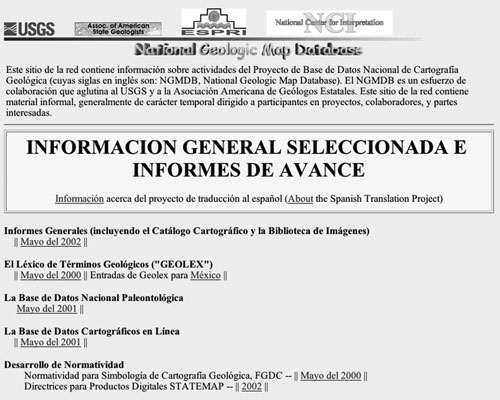 |
Figure
9. The NGMDB Spanish
language website, containing translations of selected technical reports
and geologic names of Mexico as found in GEOLEX. |
ACKNOWLEDGMENTS
The authors thank the members of the NGMDB project staff and collaborators for their enthusiastic and expert support, without whom the project would not be possible. In particular, we thank: Ed Pfeifer, Alex Acosta, Dennis McMacken, Jana Ruhlman, and Michael Gishey (USGS, Flagstaff and Tucson, AZ; Website and database management), Chuck Mayfield and Nancy Blair (USGS Library; Map Catalog content), Bruce Wardlaw (Paleontology Database), Robert Wardwell (USGS, Vancouver, WA; Image Library) and Kevin Laurent, Jeremy Skog, and Ben Carter (USGS, Reston, VA; Image Library), Steve Richard (Arizona Geological Survey, Tucson, AZ; data model and science terminology), Jonathan Matti (USGS, Tucson, AZ; data model and science terminology), and Jordan Hastings (USGS, Santa Barbara, CA; data model). We also thank the many committee members who provided technical guidance and standards (Appendix A).
REFERENCES
Asch, Kristine, 2003, CGMW Working Group on standards for digital geological data (“DIMAS”), in Soller, D.R., ed., Digital Mapping Techniques ’03—Workshop proceedings: U.S. Geological Survey Open-File Report 03-471, p. 193-194, accessed at http://pubs.usgs.gov/of/2003/of03-471/asch/.
Berquist, C.R., Jr., and Soller, D.R., 2001, Map authorship and citation guidelines: Summary of a discussion session, in Soller, D.R., ed., Digital Mapping Techniques ’01—Workshop proceedings: U.S. Geological Survey Open-File Report 01-223, p. 159-164, accessed at http://pubs.usgs.gov/of/2001/of01-223/berquist.html.
Johnson, B.R., Brodaric, B., Raines, G.L., Hastings, J., and Wahl, R., 1998, Digital geologic map data model v. 4.3: AASG/USGS Data Model Working Group Report, accessed at http://nadm-geo.org/.
Ludascher, Bertram, Lin, Kai, Brodaric, Boyan, and Baru, Chaitan, 2003, GEON: Toward a cyberinfrastructure for the geosciences—A prototype for geologic map integration via domain ontologies, in Soller, D.R., ed., Digital Mapping Techniques ’03—Workshop Proceedings: U.S. Geological Survey Open-File Report 03-471, p. 223-229, accessed at http://pubs.usgs.gov/of/2003/of03-471/ludascher/.
Mac Lachlan, M.E., and others, compilers, 1996, Stratigraphic nomenclature databases for the United States, its possessions, and territories: U.S. Geological Survey Digital Data Series DDS-6, Release 3, one CD-ROM.
North American Geologic Map Data Model (NADM) Steering Committee Data Model Design Team, 2004, NADM Conceptual Model 1.0—A Conceptual Model for Geologic Map Information: U.S. Geological Survey Open-File Report 2004-1334, 60p., accessed at http://pubs.usgs.gov/of/2004/1334/.
Powell, J.W., 1888, Methods of geologic cartography in use by the United States Geological Survey, in Congrès Géologique International, Compte Rendu de la 3me Session, Berlin, 1885: A.W. Schade’s Buchdruckerei, Berlin, p. 221–240.
Soller, D.R., and Berg, T.M., 2003a, The National Geologic Map Database Image Library—General concepts, in Soller, D.R., ed., Digital Mapping Techniques ’03—Workshop Proceedings: U.S. Geological Survey Open-File Report 03-471, p. 89-93, accessed at http://pubs.usgs.gov/of/2003/of03-471/soller2/.
Soller, D.R., and Berg, T.M., 2003b, The National Geologic Map Database project: Overview and progress, in Soller, D.R., ed., Digital Mapping Techniques ’03—Workshop Proceedings: U.S. Geological Survey Open-File Report 03-471, p. 57-77, accessed at http://pubs.usgs.gov/of/2003/of03-471/soller1/.
Soller, D.R., and Lindquist, Taryn, 2000, Development and public review of the draft “Digital cartographic standard for geologic map symbolization”, in Soller, D.R., ed., Digital Mapping Techniques ’00—Workshop Proceedings: U.S. Geological Survey Open-File Report 00-325, p. 43-47, accessed at http://pubs.usgs.gov/of/of00-325/soller3.html.
Soller, D.R., Berg, T.M., and Wahl, Ron, 2000, Developing the National Geologic Map Database, phase 3—An online, “living” database of map information, in Soller, D.R., ed., Digital Mapping Techniques ’00—Workshop Proceedings: U.S. Geological Survey Open-File Report 00-325, p. 49-52, accessed at http://pubs.usgs.gov/of/of00-325/soller4.html.
Soller, D.R., Brodaric, Boyan, Hastings, J.T., Wahl, Ron, and Weisenfluh, G.A., 2002, The central Kentucky prototype: An object-oriented geologic map data model for the National Geologic Map Database: U.S. Geological Survey Open-File Report 02-202, 38 p., accessed at http://pubs.usgs.gov/of/2002/of02-202/.
Soller, D.R., Duncan, Ian, Ellis, Gene, Giglierano, Jim, and Hess, Ron, 1999, Proposed guidelines for inclusion of digital map products in the National Geologic Map Database, in Soller, D.R., ed., Digital Mapping Techniques ’99—Workshop Proceedings: U.S. Geological Survey Open-File Report 99-386, p. 35-38, accessed at http://pubs.usgs.gov/of/of99-386/soller2.html.
Soller, D.R., Lindquist, T.A., and Matti, J.C., 2002, Field description of the scientific and locational accuracy of geologic features (a part of the draft FGDC geologic map symbolization standard), in Soller, D.R., ed., Digital Mapping Techniques ’02—Workshop Proceedings: U.S. Geological Survey Open-File Report 02-370, p. 33-40, accessed at http://pubs.usgs.gov/of/2002/of02-370/soller1.html.
Soller, D.R., Wahl, Ron, Weisenfluh, Jerry, Brodaric, Boyan, Hastings, Jordan, Laudati, Robert, and Fredericks, Roger, 2001, Progress report on the National Geologic Map Database, phase 3: An online database of map information, in Soller, D.R., ed., Digital Mapping Techniques ’01—Workshop proceedings: U.S. Geological Survey Open-File Report 01-223, p. 71-78, accessed at http://pubs.usgs.gov/of/2001/of01-223/soller2.html.
Stamm, N.R., Wardlaw, B.R., and Soller, D.R., 2000, GEOLEX—The National Geologic Map Database’s geologic names lexicon, in Soller, D.R., ed., Digital Mapping Techniques ’00—Workshop Proceedings: U.S. Geological Survey Open-File Report 00-325, p. 31-42, accessed at http://pubs.usgs.gov/of/2000/of00-325/stamm.html.
Wahl, R.R., Soller, D.R., and Yeldell, Steven, 2000, Prototype Implementation of the NADMSC Draft Standard Data Model, Greater Yellowstone Area, in Soller, D.R., ed., Digital Mapping Techniques ’00—Workshop Proceedings: U.S. Geological Survey Open-File Report 00-325, p. 57-63, accessed at http://pubs.usgs.gov/of/of00-325/wahl.html.
Wardlaw, B.R., Stamm, N.R., and Soller, D.R., 2001, The U.S. Geological Survey National Paleontological Database, in Soller, D.R., editor, Digital Mapping Techniques ’01—Workshop proceedings: U.S. Geological Survey Open-File Report 01-223, p. 59-70, accessed at http://pubs.usgs.gov/of/2001/of01-223/wardlaw.html.
Appendix A
Principal committees and people collaborating with the National Geologic Map Database project.
Digital Geologic Mapping Committee of the Association of American
State Geologists:
Tom Berg (Ohio Geological Survey and Committee Chair)
Rick Allis (Utah Geological Survey)
Larry Becker (Vermont Geological Survey)
Rick Berquist (Virginia Division of Mineral Resources)
Jim Cobb (Kentucky Geological Survey)
Ian Duncan (Texas Bureau of Economic Geology)
Rich Lively (Minnesota Geological Survey)
Jay Parrish (Pennsylvania Geological Survey)
Bill Shilts (Illinois State Geological Survey)
Nick Tew (Alabama Geological Survey)
Harvey Thorleifson (Minnesota Geological Survey)
Technical Advisory Committee:
Boyan Brodaric (Geological Survey of Canada)
David Collins (Kansas Geological Survey)
Larry Freeman (Alaska Division of Geological & Geophysical Surveys)
Jordan Hastings (University of California, Santa Barbara)
Dan Nelson (Illinois State Geological Survey)
Stephen Richard (Arizona Geological Survey)
Jerry Weisenfluh (Kentucky Geological Survey)
Map Symbol Standards Committee:
Dave Soller (U.S. Geological Survey and Committee Coordinator)
Tom Berg (State Geologist, Ohio Geological Survey)
Bob Hatcher (University of Tennessee, Knoxville)
Mark Jirsa (Minnesota Geological Survey)
Taryn Lindquist (U.S. Geological Survey)
Jon Matti (U.S. Geological Survey)
Jay Parrish (State Geologist, Pennsylvania Geological Survey)
Jack Reed (U.S. Geological Survey)
Steve Reynolds (Arizona State University)
Byron Stone (U.S. Geological Survey)
AASG/USGS Data Capture Working Group:
Dave Soller (U.S. Geological Survey and Group Chair)
Warren Anderson (Kentucky Geological Survey)
Rick Berquist (Virginia Geological Survey)
Elizabeth Campbell (Virginia Division of Mineral Resources)
Rob Krumm (Illinois State Geological Survey)
Scott McCulloch (West Virginia Geological and Economic Survey)
Gina Ross (Kansas Geological Survey)
George Saucedo (California Geological Survey)
Barb Stiff (Illinois State Geological Survey)
Tom Whitfield (Pennsylvania Geological Survey)
DMT Listserve:
Maintained by Doug Behm, University of Alabama
AASG/USGS Metadata Working Group:
Peter Schweitzer (U.S. Geological Survey and Group Chair)
Dan Nelson (Illinois State Geological Survey)
Greg Hermann (New Jersey Geological Survey)
Kate Barrett (Wisconsin Geological and Natural History Survey)
Ron Wahl (U.S. Geological Survey)
AASG/USGS Data Information Exchange Working Group:
Dave Soller (U.S. Geological Survey and Group Chair)
Ron Hess (Nevada Bureau of Mines and Geology)
Ian Duncan (Virginia Division of Mineral Resources)
Gene Ellis (U.S. Geological Survey)
Jim Giglierano (Iowa Geological Survey)
AASG/USGS Data Model Working Group:
Gary Raines (U.S. Geological Survey and Group Chair)
Boyan Brodaric (Geological Survey of Canada)
Jim Cobb (Kentucky Geological Survey)
Ralph Haugerud (U.S. Geological Survey)
Greg Hermann (New Jersey Geological Survey)
Bruce Johnson (U.S. Geological Survey)
Jon Matti (U.S. Geological Survey)
Jim McDonald (Ohio Geological Survey)
Don McKay (Illinois State Geological Survey)
Steve Schilling (U.S. Geological Survey)
Randy Schumann (U.S. Geological Survey)
Bill Shilts (Illinois State Geological Survey)
Ron Wahl (U.S. Geological Survey)
North American Data Model Steering Committee:
Dave Soller (U.S. Geological Survey and Committee Coordinator)
Tom Berg (Ohio Geological Survey)
Boyan Brodaric (Geological Survey of Canada and Chair of the Data Model Design
Technical Team)
Peter Davenport (Geological Survey of Canada)
Bruce Johnson (U.S. Geological Survey and Chair of the Data Interchange Technical
Team)
Rob Krumm (Illinois State Geological Survey)
Jonathan Matti (U.S. Geological Survey and Chair of the Science Language Technical
Team)
Scott McColloch (West Virginia Geological and Economic Survey)
Steve Richard (Arizona Geological Survey)
Peter Schweitzer (U.S. Geological Survey)
Loudon Stanford (Idaho Geological Survey)
Jerry Weisenfluh (Kentucky Geological Survey)
IUGS Commission for the Management and Application of Geoscience
Information
Dave Soller (U.S. Geological Survey, Council Member)
Conceptual model/Interchange Task Group (of the Data Model Collaboration
Working Group of the IUGS Commission for the Management and Application of
Geoscience Information)
Steve Richard (Arizona Geological Survey, Task Group
Member)
DIMAS (Digital Map Standards Working Group of the Commission
for the Geological Map of the World)
Dave Soller (U.S. Geological Survey, Working
Group Member)
NGDMB contact-persons in each State geological
survey:
These people help the NGMDB with the Geoscience Map Catalog, GEOLEX, the Geologic
Map Image Library, and the Mapping in Progress Database. Please see http://ngmdb.usgs.gov/info/statecontacts.html for this list.
Appendix B
List of progress reports on the National Geologic Map Database, and Proceedings of the Digital Mapping Techniques workshops.
Soller, D.R., editor, 2003, Digital Mapping Techniques ’03—Workshop Proceedings: U.S. Geological Survey Open-File Report 03–471, 262 p., accessed at http://pubs.usgs.gov/of/2003/of03-471/.
Soller, D.R., editor, 2002, Digital Mapping Techniques ’02—Workshop Proceedings: U.S. Geological Survey Open-File Report 02–370, 214 p., accessed at http://pubs.usgs.gov/of/2002/of02-370/.
Soller, D.R., editor, 2001, Digital Mapping Techniques ’01—Workshop Proceedings: U.S. Geological Survey Open-File Report 01–223, 248 p., accessed at http://pubs.usgs.gov/of/2001/of01-223/.
Soller, D.R., editor, 2000, Digital Mapping Techniques ’00—Workshop proceedings: U.S. Geological Survey Open-File Report 00–325, 209 p., accessed at http://pubs.usgs.gov/of/of00-325/.
Soller, D.R., editor, 1999, Digital Mapping Techniques ’99—Workshop proceedings: U.S. Geological Survey Open-File Report 99–386, 216 p., accessed at http://pubs.usgs.gov/of/of99-386/front.html.
Soller, D.R., editor, 1998, Digital Mapping Techniques ’98—Workshop Proceedings: U.S. Geological Survey Open-File Report 98–487, 134 p., accessed at http://pubs.usgs.gov/of/of98-487/.
Soller, D.R., editor, 1997, Proceedings of a workshop on digital mapping techniques: Methods for geologic map data capture, management, and publication: U.S. Geological Survey Open-File Report 97–269, 120 p., accessed at http://pubs.usgs.gov/of/of97-269/.
Soller, D.R., and Berg, T.M., 2003, The National Geologic Map Database project: Overview and progress, in Soller, D.R., ed., Digital Mapping Techniques ’03—Workshop Proceedings: U.S. Geological Survey Open-File Report 03–471, p. 57–77, accessed at http://pubs.usgs.gov/of/2003/of03-471/soller1/.
Soller, D.R., and Berg, T.M., 2002, The National Geologic Map Database: A progress report, in Soller, D.R., editor, Digital Mapping Techniques ’02—Workshop proceedings: U.S. Geological Survey Open-File Report 02–370, p. 75–83, accessed at http://pubs.usgs.gov/of/2002/of02-370/soller2.html.
Soller, D.R., and Berg, T.M., 2001, The National Geologic Map Database--A progress report, in Soller, D.R., editor, Digital Mapping Techniques ’01—Workshop proceedings: U.S. Geological Survey Open-File Report 01–223, p. 51–57, accessed at http://pubs.usgs.gov/of/2001/of01-223/soller1.html.
Soller, D.R., and Berg, T.M., 2000, The National Geologic Map Database--A progress report, in Soller, D.R., editor, Digital Mapping Techniques ’00—Workshop proceedings: U.S. Geological Survey Open-File Report 00–325, p. 27–30, accessed at http://pubs.usgs.gov/of/of00-325/soller2.html.
Soller, D.R., and Berg, T.M., 1999a, Building the National Geologic Map Database: Progress and challenges, in Derksen, C.R.M, and Manson, C.J., editors, Accreting the continent’s collections: Geoscience Information Society Proceedings, v. 29, p. 47–55, accessed at http://ngmdb.usgs.gov/info/reports/gisproc98.html.
Soller, D.R., and Berg, T.M., 1999b, The National Geologic Map Database—A progress report, in Soller, D.R., editor, Digital Mapping Techniques ’99—Workshop proceedings: U.S. Geological Survey Open-File Report 99–386, p. 31–34, accessed at http://pubs.usgs.gov/of/of99-386/soller1.html.
Soller, D.R., and Berg, T.M., 1998, Progress Toward Development of the National Geologic Map Database, in Soller, D.R., editor, Digital Mapping Techniques ’98—Workshop proceedings: U.S. Geological Survey Open-File Report 98–487, p. 37–39, accessed at http://pubs.usgs.gov/of/of98-487/soller2.html.
Soller, D.R., and Berg. T.M., 1997, The National Geologic Map Database—A progress report: Geotimes, v. 42, no. 12, p. 29–31, accessed at http://ngmdb.usgs.gov/info/reports/geotimes97.html.
Soller, D.R., and Berg, T.M., 1995, Developing the National Geologic Map Database: Geotimes, v. 40, no. 6, p. 16–18, accessed at http://ngmdb.usgs.gov/info/reports/geotimes95.html.