U.S. Geological Survey
Open-file Report 2005-1170
Nearshore Benthic Habitat GIS for the Channel Islands National Marine Sanctuary and Southern California State Fisheries Reserves Volume IIVersion 1.0 By Guy R. Cochrane1, James E. Conrad1, Jane A. Reid1, 1Coastal and Marine Geology Program, USGS |
|||||||||||
|
GIS Description Regional Data Mapped areas |
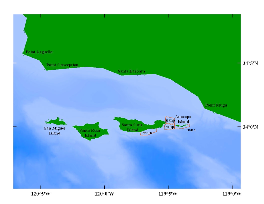
To see a large view the location map (figure 1), AbstractThe nearshore benthic habitat of the Santa Barbara coast and Channel Islands supports diverse marine life that is commercially, recreationally, and intrinsically valuable. Some of these resources are known to be endangered including a variety of rockfish species and the white abalone. Agencies of the state of California and the United States have been mandated to preserve and enhance these resources. Data from sidescan sonar, bathymetry, video and dive observations, and physical samples are consolidated in a geographic information system (GIS). The GIS provides researchers and policymakers a view of the relationship among data sets to assist scientific research and to help with economic and social policy-making decisions regarding this protected environment. Citation:
IntroductionThe U.S. Geological Survey (USGS) has conducted a benthic habitat mapping research project since 1999 to map the marine geological environment (Cochrane et al., 2002). The focus of the USGS study is on the broad, flat continental shelf, areas shallower than 100 m (328 ft), between Point Arguello to the north and Point Dume to the south and around the northern Channel Islands. The project tasks focused on mapping the seafloor with sonar, collecting video data in the survey areas, and compiling existing sediment sample data. Polygon areas classified by bottom habitat were generated from this research. Geographic mapping priorities are based on the location of state and national Marine Protected Areas (MPAs). Areas within MPAs and comparable areas outside MPAs are mapped to allow managers to inventory habitats and monitor the effectiveness of the MPA by comparing protected areas to comparable unprotected areas. The recently established State MPAs in the study area are the result of the Marine Life Protection Act (MLPA). The MLPA can be found in Chapter 10.5 of the California Fish and Game Code, Sections 2850 to 2863. The purpose of the MLPA is to improve the array of marine MPAs existing in California waters through the adoption of a Marine Life Protection Program and a comprehensive master plan. The MLPA states that "marine life reserves" (defined as no-take areas) are essential elements of an MPA system because they "protect habitat and ecosystems, conserve biological diversity, provide a sanctuary for fish and other sea life, enhance recreational and educational opportunities, provide a reference point against which scientists can measure changes elsewhere in the marine environment, and may help rebuild depleted fisheries". Volume I of the the Southern California habitat GIS (Cochrane et al., 2003) focused on state fish reserves designed before MLPA. Section 2851 of the California Department of Fish and Game (CDFG) Code refers to the lack of a clearly defined purpose and scientific guidelines when these reserves were established. Six goals for the MLPA are established: 1) To protect the natural diversity and abundance of marine life, and the structure, function, and integrity of marine ecosystems; 2) To help sustain, conserve, and protect marine life populations, including those of economic value, and rebuild those that are depleted; 3) To improve recreational, educational, and study opportunities provided by marine ecosystems that are subject to minimal human disturbance, and to manage these uses in a manner consistent with protecting biodiversity; 4) To protect the natural marine heritage, including protection of representative and unique marine life habitats in California waters for their intrinsic value; 5) To ensure that California's MPAs have clearly defined objectives, effective management measures, and adequate enforcement, that are based on sound scientific guidelines; 6) To ensure that the state's MPAs are designed and managed, to the extent possible, as a network. More information is available from California Department of Fish and Game Marine Region website. MPAs mapped in this GIS volume were established through a cooperative effort by the Channel Islands National Marine Sanctuary (CINMS) and CDFG. A Sanctuary Advisory Council (SAC) was formed in December 1998 to provide a stakeholder-balanced, regionally-based forum for advice to the Sanctuary manager. The resulting MPAs will be included in a larger federal system of MPAs established to further the goals of National Marine Sanctuaries Act (16 U.S.C. 1431 et seq.), National Wildlife Refuge System Administration Act of 1966 (16 U.S.C. 668dd-ee), National Park Service Organic Act (16 U.S.C. 1 et seq.), National Historic Preservation Act (16 U.S.C. 470 et seq.), Wilderness Act (16 U.S.C. 1131 et seq.), Magnuson-Stevens Fishery Conservation and Management Act (16 U.S.C. 1801 et seq.), Coastal Zone Management Act (16 U.S.C. 1451 et seq.), Endangered Species Act of 1973 (16 U.S.C. 1531 et seq.), Marine Mammal Protection Act (16 U.S.C. 1362 et seq.), Clean Water Act of 1977 (33 U.S.C. 1251 et seq.), National Environmental Policy Act, as amended (42 U.S.C. 4321 et seq.), Outer Continental Shelf Lands Act (42 U.S.C. 1331 et seq). More information about the National MPA system is available at the Marine Protected Areas of the United States website. The California Fish and Game Commission (CFGC) has approved the proposed network of marine reserves in state waters. Those proposed for federal waters are currently being evaluated by relevant agencies. The CFGC released a Notice of Preparation of regulations, and on January 26, 2002 released an Initial Statement of Reasons for Regulatory Action to designate MPAs at the CINMS and Draft Regulations for all of the alternatives. The Sanctuary released the Final Environmental Impact Statement (EIS) by publishing a notice of availability in the Federal Register in 2004. More information on the status of MPAs is available from the PacificMPA.org website. Revisions and UpdatesThis GIS compilation will be revised and updated as new data become available. The most flexible way to do this will be to post changes on the internet (online). Versions will be published online and links to each will be available at http://walrus.wr.usgs.gov/nearshorehab. To check on the volume and version of our GIS look at Revision History. The hosting site could change. If there is no forwarding link, go the the USGS home page and search for keywords Southern California habitat. File and Data FormatsText files (.txt) on the web site may be viewed without special software. Hypertext mark-up language files (.html) require a browser such as Netscape Navigator or Internet Explorer. GIF (.gif), JPEG (.jpg) or TIFF (.tif) images may be viewed by many common image software packages. The data files require ESRI ArcExplorer, ArcView, or ArcInfo. ArcExplorer is an application that ESRI licenses without charge for Windows operating systems. ArcView and ArcInfo are licensed applications that must be purchased. The data were compiled in ArcInfo (versions 8.0.2 and 9.0) ESRI, 1982-2004), a commercial GIS, in the UTM Zone 10 coordinate system with datum NAD83. Raster data layers are in ArcInfo GRID format or are registered TIFF images. Point, line and polygon features are in ESRI shapefile format. Shapefiles were generated in geographic coordinates with datum NAD83. Each data layer is accompanied by Federal Geographic Data Committee (FGDC) compliant metadata and an overview map. AcknowledgmentsThe authors would like to thank the staff of the CINMS for their support of this project. Mike Boyle, Fred Payne and others at the USGS Western Region Marine Facility expertly assisted with the acquistion and logistics. We would also like to thank the crews of the NOAA R/V MacArthur, and the NOAA R/V Shearwater. Submersible time for bottom video was contributed by Sylvia Earle and the NOAA Sustainable Seas Expedition. This publication benefited from technical review by Roberto Anima and Jodi Harney. ReferencesAnderson, T.J., G.R. Cochrane, D.A. Roberts, H. Chezar, and G. Hatcher, in press. A systematic real-time method to characterize seafloor habitats and benthic macro-organisms: Habitat mapping with a side-scan sonar and towed camera-sled. Proceedings of Geohab. Blondel, P., 1996. Segmentation of the Mid-Atlantic Ridge south of the Azores, based on acoustic classification of TOBI data, in MacLeod, C.J., Tyler, P.A., and Walker, C.L. (Eds.), Tectonic, Magmatic, Hydrothermal and Biological Segmentation of Mid-Ocean Ridges: Boulder, CO, Geological Society Special Publication No. 118, p. 17-28. Blondel, P., and Murton, B.J., 1997. Handbook of Seafloor Sonar Imagery: West Sussex, England, 314 p. California Department of Fish and Game, Marine Region website [http://www.dfg.ca.gov/mrd/mlpa/] CDFG and CINMS, California Department of Fish and Game, Channel Islands National Marine Sanctuary, 2001, A recommendation for Marine Protected Areas in the Channel Islands National Marine Sanctuary. Channel Islands National Marine Sanctuary, Marine Reserves [http://channelislands.nos.noaa.gov/marineres/main.html] Chavez, P. S., Jr., 1984. U.S. Geological Survey mini image processing system (MIPS). U.S. Geological Survey Open-File Report 84-880, 12 p. Cochrane, G.R., N.M. Nasby, J.A. Reid, B. Waltenberger, K.M. Lee, 2003. Nearshore Benthic Habitat GIS for the Channel Islands National Marine Sanctuary and Southern California State Fisheries Reserves Volume 1, U.S. Geological Survey Open-file Report 03-85, [http://geopubs.wr.usgs.gov/open-file/of03-85/]. Cochrane, G.R. and Lafferty, K.D., 2002. Use of acoustic classification of sidescan sonar data for mapping benthic habitat in the Northern Channel Islands, California: Continental Shelf Research, v. 22, p. 683-690. Cochrane, G.R., Vetter, R.D., Nasby, N.M., Taylor, C.A., and Cosgrove, R., 2002. Benthic habitats in four marine-reserve locations surrounding the Santa Barbara Basin. Final Report Part II. in, Marine Ecological Reserves Research Program: Research Results 1996-2001, California Sea Grant, CDROM. [link to pdf on website] Dibblee, T.W., Jr., 2001a. Geologic map of Anacapa and Santa Barbara Islands, Channel Islands National Park, Ventura and Santa Barbara Counties, California: Dibblee Geological Foundation Map DF-73, scale 1:24,000. Dibblee, T.W., Jr., 2001b. Geologic map of eastern Santa Cruz Island, Santa Barbara County, California: Dibblee Geological Foundation Map DF-78, scale 1:24,000. Greene, G.H., Yoklavich, M.M., Starr, R.M., O‘Connell, V.M., Wakefield, W.W., Sullivan, D.E., McRea, J.E., and Cailliet, G.M., 1999. A classification scheme for deep seafloor habitats. Oceanologica Acta, v. 22, p. 663-678. Jenkins, C.J., 1997, Building offshore soils databases, Sea Technology, 38(12):25-28 Marine Protected Areas of the United States, [http://www.mpa.gov/] Presidential Documents Executive Order 13158 of May 26, Presidential Documents 34909, Marine Protected Areas, 2000, Federal Register, Vol. 65, No. 105. Shokr, M.E., 1991. Evaluation of second-order texture parameters for sea ice classification from radar images: Journal of Geophysical Research, v. 96, p. 10625-10640. USGS, 1999a, http://walrus.wr.usgs.gov/infobank/b/b199sc/html/b-1-99-sc.meta.html USGS, 1999b, http://walrus.wr.usgs.gov/infobank/b/b299sc/html/b-2-99-sc.meta.html USGS, 2000a, http://walrus.wr.usgs.gov/infobank/m/m199sc/html/m-1-99-sc.meta.html USGS, 2000b, http://walrus.wr.usgs.gov/infobank/m/m100sc/html/m-1-00-sc.meta.html USGS, 2004, http://walrus.wr.usgs.gov/infobank/s/s504sc/html/s-5-04-sc.meta.html For more information, contactGuy R. Cochrane |
||||||||||
|
|||||||||||
http://pubs.usgs.gov/of/2005/1170/
maintained by Michael Diggles
last modified May 15, 2008 (mfd)
USGS Privacy Statement
| Disclaimer
| Feedback
| Accessibility
Department of the Interior U.S. Geological Survey Geologic Division Coastal & Marine Geology Program