OF 07-1247: Afghanistan Aeromagnetic Survey
Afghanistan Composite Magnetic Anomaly Map at 5000 m Above Ground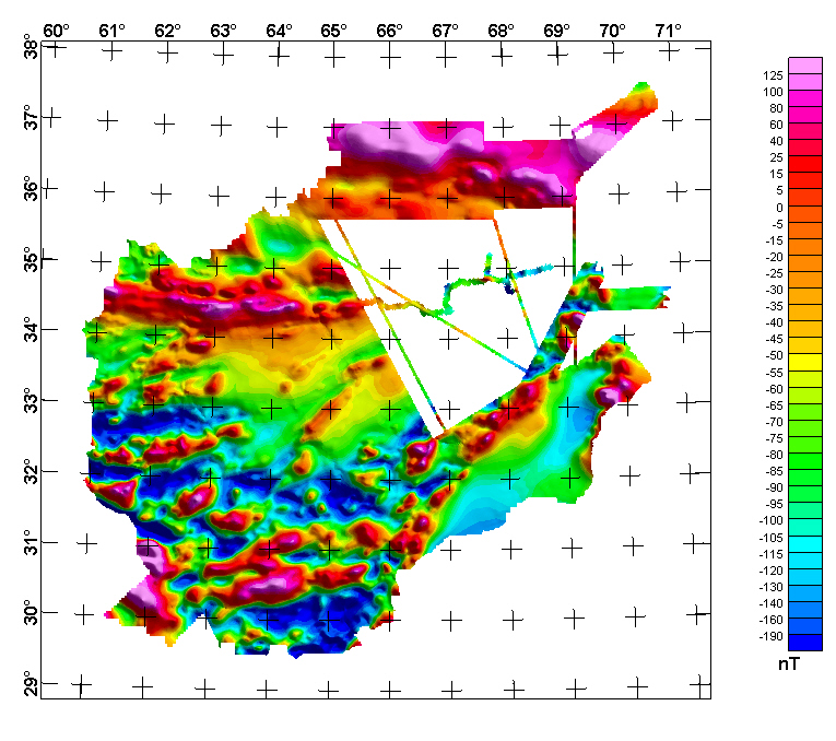
The above image was generated from a grid made by merging multiple Afghanistan magnetic anomaly grids. It is a composite of the 2006 aeromagnetic and ground magnetic survey data described in this report, merged with the residual magnetic field data found in U.S. Geological Survey Open-File Report 2006-1204 and Open-File Report 2006-1325. The data were gridded at 1000 m spacing. The simulated elevation of the displayed grid is 5000 m above terrain. The illumination in the image is from the northeast. INTRODUCTIONAfghanistan’s geologic setting indicates significant natural resource potential. While important mineral deposits and petroleum resources have been identified, much of the country’s potential remains unknown. Airborne geophysical surveys are a well accepted and cost effective method for obtaining information of the geological setting of an area without the need to be physically located on the ground. A regional airborne geophysical survey was proposed due to the security situation and the large areas of Afghanistan that have not been covered using geophysical exploration methods. Acting upon the request of the Islamic Republic of Afghanistan Ministry of Mines, the U.S. Geological Survey contracted with the U.S. Naval Research Laboratory to jointly conduct an airborne geophysical and remote sensing survey of Afghanistan. Data collected during this survey will provide basic information for mineral and petroleum exploration studies that are important for the economic development of Afghanistan. Additionally, use of this data is broadly applicable in the assessment of water resources and natural hazards, the inventory and planning of civil infrastructure and agricultural resources, and the construction of detailed maps. The U.S. Geological Survey is currently funded by the U.S. Agency of International Development to conduct resource assessments of the country of Afghanistan for mineral, energy, coal, and water resources, and geologic hazards. These geophysical and remote sensing data will be used directly in the resource and hazard assessments. OPERATIONSThe U.S. Geological Survey and U.S. Naval Research Laboratory jointly conducted an airborne geophysical and remote sensing survey in Afghanistan during the summer of 2006. The Islamic Republic of Afghanistan Ministry of Mines and Industries provided the major funding for this work with additional support from the U.S. Naval Research Laboratory (NRL), U.S. Geological Survey (USGS), and U.S. Department of Defense Reconstruction Office (ARO). Approximately 70 people in Afghanistan alone were involved with implementing the airborne survey. Thirteen USGS and NRL civilian scientists conducted the survey with the assistance of 24 scientists from the Afghanistan Geological Survey, the Afghanistan Head Office for Geodesy and Cartography, and the Ministry of Mines and Industries. Twenty-eight military personnel from the NRL Scientific Development Squadron ONE (VXS-1) and two geomagnetic technicians from the Canadian Forces Mapping and Charting Establishment were deployed and provided critical operational support. A research-modified Lockheed NP-3D “Orion” aircraft served as the survey instrument platform (fig. 1). The NRL VXS-1 heavyweight P3-B was uniquely configured with a suite of geophysical and remote sensing instruments and specially modified for operation in a combat theater. The geophysical instrumentation employed in this survey included:
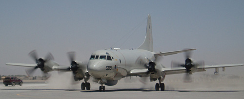 Figure 1. The Naval Research Laboratory NP-3D "Orion" taxiing at Kandahar International Airport, June, 2006 During the survey the NP-3D “Orion” was stationed at Kandahar International Airport (fig. 2), about 16 kilometers southeast of Kandahar, Afghanistan. The airport was constructed during the 1960s with financial and technical assistance from the U.S. Agency for International Development (USAID). The airport was severely damaged by Soviet military operations during 1979-89 and again during the early phases of Operation Enduring Freedom in October 2001. The airport has since been renovated.  Figure 2. Kandahar International Airport served as the base of operations for the USGS airborne geophysical and remote sensing survey of Afghanistan. The terminal has seen significant renovations recently and will eventually be ready for civilian use. Base stations were established throughout Afghanistan in order to provide correctional data in support of the airborne survey. The National Geospatial-Intelligence Agency (NGA) established a gravity reference base station at Kandahar International Airport for use as a gravity datum during the survey. Temporary Global Positioning System (GPS) and magnetic reference stations were positioned in the cities of Kandahar, Kabul, Herat, Sheberghan, and Faizabad. Afghan scientists from the Afghanistan Geological Survey, Afghanistan Head Office for Geodesy and Cartography, and Ministry of Mines and Industries operated many of these stations. The airborne geophysical and remote sensing survey of Afghanistan was completed in August 2006. The P-3 “Orion” conducted 37 individual survey flights, logging over 220 hours of flight time during the survey. Approximately two-thirds of the land area of Afghanistan was surveyed. The survey area was limited by flight restrictions imposed by U.S. Central Command (CENTCOM). During the survey 113,000 line kilometers of magnetic data, 72,000 line kilometers of gravity data, and 110,000 line kilometers of SAR data were collected. Additionally, 150,000 square kilometers of hyperspectral imagery and 300,000 square kilometers of stereo true-color photography were collected. Click Here for Data Processing Details |
Version 1.0 Posted April 2008
Refer to the README_Afghan_datafiles PDF describing data in above directory
For more information about this
|

![]() U.S. Department of the Interior | U.S. Geological Survey
U.S. Department of the Interior | U.S. Geological Survey
URL: http://pubsdata.usgs.gov/pubs/of/2007/1247/html/afghan_mag.html
Questions or Assistance: Contact USGS
Last modified: Wednesday, 07-Dec-2016 20:20:03 EST
