U.S. Geological Survey Open-File Report 2008-1196
Enhanced Sidescan-Sonar Imagery Offshore of Southeastern Massachusetts
![]() Title | Introduction | Methods | Sidescan-Sonar Imagery | Data Catalog | Acknowledgments | References | Figures | Contacts
Title | Introduction | Methods | Sidescan-Sonar Imagery | Data Catalog | Acknowledgments | References | Figures | Contacts
 |
||
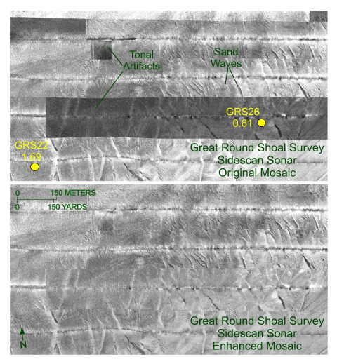
Figure 15. Detailed view of the original (top) and enhanced (bottom) sidescan-sonar mosaics from the western part of the Great Round Shoal Channel survey by the National Oceanic and Atmospheric Administration. Note the tonal artifacts in the original mosaic and how removal of the artifacts clarifies the character of the sand-wave field in the enhanced mosaic. Circles mark sampling and bottom-photography station locations, each labeled with station number and mean grain-size value (phi). Locations of views are shown in figure 14. | ||

![]() U.S. Department of the Interior |
U.S. Geological Survey
U.S. Department of the Interior |
U.S. Geological Survey
URL: http://pubsdata.usgs.gov/pubs/of/2008/1196/html/fig15.html
Page Contact Information: GS Pubs Web Contact
Page Last Modified: Wednesday, 07-Dec-2016 21:37:02 EST


