|
- Data Access
- Data Organization and Description
- Data Preview
1. Data Access
Data in this report are provided in a variety of formats. This section describes how to access the various data formats including Portable Document Format (PDF; *.pdf), Joint Photographic Experts Group format (JPEG; *.jpg), Microsoft® Excel file format (XLS; *.xls), Comma Separated Values (CSV; *.csv), ESRI® shapefile format (shapefile; *.shp, *.shx), and Binary ESRI® grid format (ESRI® grid; 'folder'). These data types are further stored and compressed within Zip files in order to facilitate Web downloads. WinZip® files of data layers are linked within the Data Preview section with specific download instructions.
If WinZip® is not currently installed on the local system, go to WinZip® <http://www.winzip.com> to download the latest version of the WinZip® utility.
- PDF Data
- Field logs and notes converted to electronic format (PDF) can be accessed using Adobe® Acrobat® or Adobe® Reader® (free version: http://get.adobe.com/reader/)
- JPEG Data
- Microsoft® Excel Spreadsheets and CSV files
- Tabular data in both Excel and CSV format can be viewed using Microsoft® Excel. CSV data can also be viewed using any text editor such as Vim (free version: http://www.vim.org/)
- Geospatial Data
- The geospatial data in this report are delivered as ESRI® grids (raster) and shapefiles (vector). Rasters are stored as Binary ESRI® grid format in the data_catalog (including the data_catalog.zip file). Vector data are stored as shapefiles within the Zip file. To view the geospatial data, the user may access the data using: ArcGIS® 9.0 or higher, ArcView® 3.x, or ArcGIS Explorer 9.x (free version for vector data: http://www.esri.com/software/arcgis/explorer/).
- These data can also be viewed within an ArcView® 3.2 project (2009-1031.apr ) or an ArcMap™ 9.2 map document (2009-1031.mxd). To view the map documents: Copy the data_catalog folder or the data_catalog Zip file (120 MB; for www downloads) to a local computer and open the ArcView® project 2009-1031.apr or the ArcMap™ 9.2 map document 2009-1031.mxd. These map documents are saved with relative links. As long as the file structure remains the same under the parent directory (data_catalog) there is no need to change drive letters or pathways. Approximately 500 MB of free space is needed to save the data and extract it to a local drive.
2. Data Organization and Description
The data in this report are separated into nine subdirectories within the data_catalog. This section describes the location of the data within the folder storage structure of the DVD or Web page.
 data_catalog data_catalog
This folder contains:
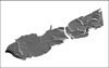
1. Basemaps: Regional bathymetry and land polygon for Apalachicola Bay area.
- apbaybathy25m – Grid: Bathymetry at 25-m resolution
- apbay25hs – Grid: Bathymetric hillshade at 25-m resolution
- ApalachicolaBaseMap - Shapefile: land polygon
* Basemap data are provided for reference purposes in their original format and coordinate system as published by the U.S. Geological Survey (Twichell and others, 2007).
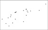
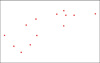
2. Core_Locations: Vibracore locations
- APP-07_CoreLocations – Shapefile, XLS, and CSV: Vibracore latitude, longitude, depth, and other properties
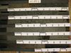
3. Core_Field_Descriptions: Field core logs and descriptive notes
- 07008-01 – PDF: Core log sheet for vibracore App-01
- 07008-05 – PDF: Core log sheet for vibracore App-05
- 07008-06 – PDF: Core log sheet for vibracore App-06
- 07008-07 – PDF: Core log sheet for vibracore App-07
- 07008-08 – PDF: Core log sheet for vibracore App-08
- 07008-09 – PDF: Core log sheet for vibracore App-09
- 07008-10 – PDF: Core log sheet for vibracore App-10
- 07008-13 – PDF: Core log sheet for vibracore App-13
- 07008-14 – PDF: Core log sheet for vibracore App-14
- 07008-15 – PDF: Core log sheet for vibracore App-15
- 07008-16 – PDF: Core log sheet for vibracore App-16
- 07008-17 – PDF: Core log sheet for vibracore App-17
- 07008-18A – PDF: Core log sheet for vibracore App-18A
- 07008-18B – PDF: Core log sheet for vibracore App-18B
- 07008-19 – PDF: Core log sheet for vibracore App-19
- 07008-20 – PDF: Core log sheet for vibracore App-20
- 07008-21 – PDF: Core log sheet for vibracore App-21
- 07008-22 – PDF: Core log sheet for vibracore App-22
- 07008-23 – PDF: Core log sheet for vibracore App-23
- 07008-24 – PDF: Core log sheet for vibracore App-24
- 07008-25 – PDF: Core log sheet for vibracore App-25
- 07008-26 – PDF: Core log sheet for vibracore App-26
- 07008-27 – PDF: Core log sheet for vibracore App-27
- 07008-28 – PDF: Core log sheet for vibracore App-28
4. Core_Photos: Core Photographs
- 07_APP_01 – JPEG: Core photograph for vibracore App-01
- 07_APP_05 – JPEG: Core photograph for vibracore App-05
- 07_APP_06 – JPEG: Core photograph for vibracore App-06
- 07_APP_07 – JPEG: Core photograph for vibracore App-07
- 07_APP_08 – JPEG: Core photograph for vibracore App-08
- 07_APP_09 – JPEG: Core photograph for vibracore App-09
- 07_APP_10 – JPEG: Core photograph for vibracore App-10
- 07_APP_13 – JPEG: Core photograph for vibracore App-13
- 07_APP_14 – JPEG: Core photograph for vibracore App-14
- 07_APP_15 – JPEG: Core photograph for vibracore App-15
- 07_APP_16 – JPEG: Core photograph for vibracore App-16
- 07_APP_17 – JPEG: Core photograph for vibracore App-17
- 07_APP_18A – JPEG: Core photograph for vibracore App-18A
- 07_APP_18B – JPEG: Core photograph for vibracore App-18B
- 07_APP_19 – JPEG: Core photograph for vibracore App-19
- 07_APP_20 – JPEG: Core photograph for vibracore App-20
- 07_APP_21 – JPEG: Core photograph for vibracore App-21
- 07_APP_22 – JPEG: Core photograph for vibracore App-22
- 07_APP_23 – JPEG: Core photograph for vibracore App-23
- 07_APP_24 – JPEG: Core photograph for vibracore App-24
- 07_APP_25 – JPEG: Core photograph for vibracore App-25
- 07_APP_26 – JPEG: Core photograph for vibracore App-26
- 07_APP_27 – JPEG: Core photograph for vibracore App-27
- 07_APP_28 – JPEG: Core photograph for vibracore App-28
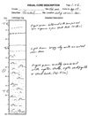
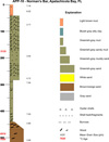
5. Core_Summary_Descriptions: Finalized core descriptions
- APP01 – JPEG: Final core description for vibracore App-01
- APP05_gs_age – JPEG: Final core description for vibracore App-05 with Grain-
- APP06 – JPEG: Final core description for vibracore App-07-06
- APP07_gs – JPEG: Final core description for vibracore App-07
- APP08 – JPEG: Final core description for vibracore App-08
- APP09 – JPEG: Final core description for vibracore App-09
- APP10_gs_age – JPEG: Final core description for vibracore App-10
- APP13_gs – JPEG: Final core description for vibracore App-13
- APP14 – JPEG: Final core description for vibracore App-14
- APP15 – JPEG: Final core description for vibracore App-15
- APP16_age – JPEG: Final core description for vibracore App-16
- APP17_gs_age – JPEG: Final core description for vibracore App-17
- APP18B_gs_age – JPEG: Final core description for vibracore App-18B
- APP19_gs_age – JPEG: Final core description for vibracore App-19
- APP20_age – JPEG: Final core description for vibracore App-20
- APP21 – JPEG: Final core description for vibracore App-21
- APP22_gs_age – JPEG: Final core description for vibracore App-22
- APP23_gs_age – JPEG: Final core description for vibracore App-23
- APP24_gs_age – JPEG: Final core description for vibracore App-24
- APP25_gs – JPEG: Final core description for vibracore App-25
- APP26 – JPEG: Final core description for vibracore App-26
- APP27_gs – JPEG: Final core description for vibracore App-27
- APP28_gs – JPEG: Final core description for vibracore App-27
**These images are "hotlinked" to the core locations (App-07_CoreLocations.shp) within the ArcMap™ 9.2 map document 2009-1031.mxd. In order to utilize hyperlinking the core locations must be selected within the Table of Contents. The hyperlink feature (lightning bolt  ) within the tools menu can then be used to display the summary sheets associated with an individual core. ) within the tools menu can then be used to display the summary sheets associated with an individual core.
- Open 2009-1031.mxd
- Select the core locations in the Table of Contents
- Select the lightning bolt tool and click on an individual core to view an image of the summary sheet.
6. Grain_Size: Grain-Size analysis data
- APP-07_GrainSize – Shapefile, XLS, and CSV: Grain-Size Analysis data for selected cores
7. Age_Dates: Radiocarbon Age data
- APP-07_AgeDates– Shapefile, XLS, and CSV: Radiocarbon Age dates for selected cores
8. Microfossils: Foraminiferal Data
- APP-07_Microfossils– Shapefile, XLS, and CSV: Microfossil counts and percentages for selected cores
*** Microfossil species names are abbreviated within the ArcGIS® attribute table to meet the maximum of 10 character restriction. Table 1 outlines the species identified by microfossil analysis and gives a key to matching the abbreviated name to the actual Genus species name.
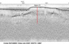
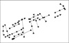
9. Seismic_Tracks_Profiles: Chirp Seismic Tracklines and Profiles with core locations
- Seismic_Cores_INT- Shapefile: Seismic tracklines that intersect cores from cruise App-07.
- AP_Bay_15_19_NS_tie_line- JPEG: Chirp Seismic Profile with vibracore App-19
- AP_Bay_Core_01- JPEG: Chirp Seismic Profile with vibracore App-01
- AP_Bay_Cores_05_08- JPEG: Chirp Seismic Profile with vibracores App-05, App-06, App-07, App-08
- AP_Bay_Cores_09_10A- JPEG: Chirp Seismic Profile with vibracores App-09, App-10
- AP_Bay_Cores_09_10B- JPEG: Chirp Seismic Profile with vibracore App-10
- AP_Bay_Core_13- JPEG: Chirp Seismic Profile with vibracore App-13
- AP_Bay_Cores_14_17- JPEG: Chirp Seismic Profile with vibracore App-14, App-15, App-16, App-17
- AP_Bay_Core_18- JPEG: Chirp Seismic Profile with vibracore App-18
- AP_Bay_Core_19- JPEG: Chirp Seismic Profile with vibracore App-19
- AP_Bay_Cores_20_21- JPEG: Chirp Seismic Profile with vibracore App-20, App-21
- AP_Bay_Core_22- JPEG: Chirp Seismic Profile with vibracore App-22
- AP_Bay_Core_23- JPEG: Chirp Seismic Profile with vibracore App-23
- AP_Bay_Core_24A- JPEG: Chirp Seismic Profile with vibracore App-24
- AP_Bay_Core_24B- JPEG: Chirp Seismic Profile with vibracore App-24
- AP_Bay_Core_25A- JPEG: Chirp Seismic Profile with vibracore App-25
- AP_Bay_Core_25B- JPEG: Chirp Seismic Profile with vibracore App-25
- AP_Bay_Core_26- JPEG: Chirp Seismic Profile with vibracore App-26
- AP_Bay_Core_27- JPEG: Chirp Seismic Profile with vibracore App-27
- AP_Bay_Core_28- JPEG: Chirp Seismic Profile with vibracore App-28
****These images are "hotlinked" to the seismic tracklines (Seismic_Cores_INT.shp) within the ArcMap™ 9.2 map document 2009-1031.mxd. In order to utilize hyperlinking the seismic tracklines must be selected within the Table of Contents. The hyperlink feature (lightning bolt ) within the tools menu can then be used to display the seismic profile associated with an individual seismic trackline.
- Open 2009-1031.mxd
- Select the seismic trackline in the Table of Contents
- Select the lightning bolt tool and click on a trackline to view an image of the seismic profile.
10. Map documents:
2009-1031.apr – ArcView® 3.2 document containing selected data layers described above.
2009-1031.mxd – ArcMap™ 9.2 map document containing selected data layers described above.
3. Data Preview
This section describes how to download data from this report via the DVD or web page.
To download data, right click on the link in the 'Download zip file' column in the table below. Select 'Save Target As...' to save a compressed WinZip® file to the local hard drive. If WinZip® is not currently installed on the local system, go to WinZip® to download the latest version of the utility. Each data set is listed in the table below with a thumbnail image, format identifier, and a relative path to the file directory.
|