
|
The nearshore North Pacific SST data are available for
download as MS Access databases (in 2003 .mdb format). Unlike the GIS
data, these data are not ordered by year. Rather, they are arranged
by geographical province (fig. 3). Each province database includes
all of the individual monthly tables over all available years (September
1981 — December 2009) for points located within the specified province.
To download the databases, click on the appropriate province name in
the
table below.
| Province |
Description |
File Type |
File Size |
Metadata |
| Cold Temperate
Northeast Pacific |
Access 2003 database containing Nearshore SSTs of the Cold Temperate
Northeast Pacific Ocean Province over the period 9/1981 - 12/2009. |
.mdb |
590 MB |
|
| Cold Temperate
Northwest Pacific |
Access 2003 database containing Nearshore SSTs of the Cold Temperate
Northwest Pacific Ocean Province over the period 9/1981 - 12/2009. |
.mdb |
1.8 GB |
| Warm Temperate
Northeast Pacific |
Access 2003 database containing Nearshore SSTs of the Warm Temperate
Northeast Pacific Ocean Province over the period 9/1981 - 12/2009. |
.mdb |
1.1 GB |
| Warm Temperate
Northwest Pacific |
Access 2003 database containing Nearshore SSTs of the Warm Temperate
Northwest Pacific Ocean Province over the period 9/1981 - 12/2009. |
.mdb |
454 MB |
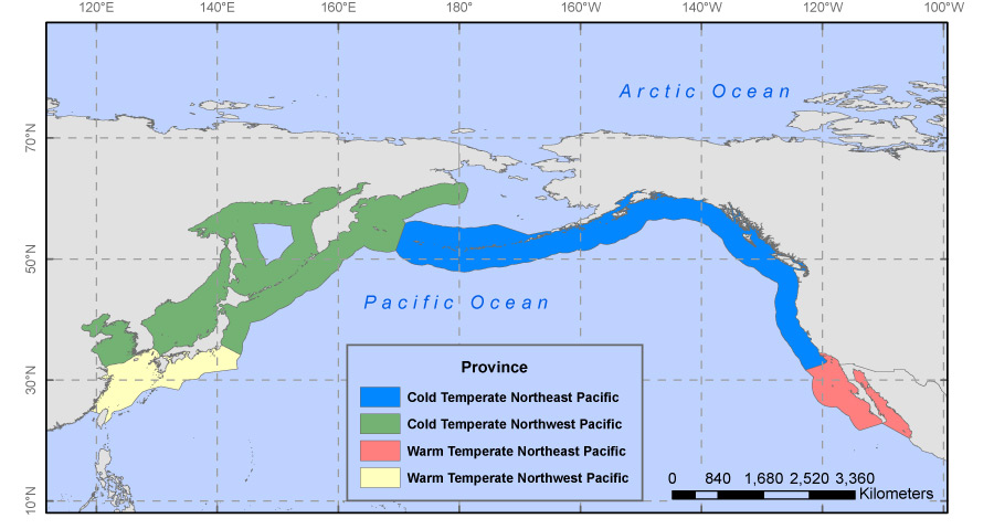
Figure 3. Map of the four Marine Ecosystem of the World
(MEOW) Provinces that comprise the Temperate Northern Pacific and Arctic
Realms (Spalding and others, 2007). The Cold Temperate Northeast Pacific
includes the Aleutian Islands and the Pacific coast of North America,
from Alaska to Southern California. The Warm Temperate Northeast Pacific
contains the Baja Region. The Cold Temperate Northwest Pacific includes
the Kamchatka coast of the Bering Sea and the Kuril Islands as well as
the inland seas of Okhotsk, Japan, and the Yellow Sea, and much of the
Japanese coast. Lastly, the Warm Temperate Northwest Pacific encompasses
the East China Sea, the south coast of Korea and the Pacific coasts of
Kyushu, Shikoku, and part of the Honshu Islands of Japan.
|

