
|
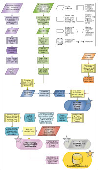 |
Figure 1. Flowchart detailing
the data processing steps taken to convert AVHRR Pathfinder 4 km HDF
data into North Pacific nearshore SST data in the form of ESRI GRIDs,
ESRI shapefiles, text .csv files, and Access 2003 Databases. The flowchart color scheme emphasizes the relation of a particular input to its processes and outputs by using the same shades. New inputs or inputs derived through the combination of previous outputs have unique colors. Yellow rectangular boxes denote pre-existing (canned) MGET or ArcGIS tools used in processing. The final products marked with star symbols represent the datasets available through this report. |
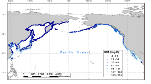 |
Figure 2. Example of
a monthly mean SST map (April 2009) of the North Pacific Ocean nearshore
region. Resolution is 4 km. The color gradient along the nearshore
corresponds to the SSTs at those locations. |
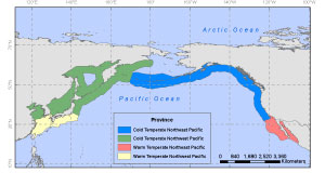 |
Figure 3. Map of the
four Marine Ecosystem of the World (MEOW) Provinces that comprise
the Temperate Northern Pacific and Arctic Realms (Spalding and others,
2007). The Cold Temperate Northeast Pacific includes the Aleutian
Islands and the Pacific coast of North America, from Alaska to Southern
California. The Warm Temperate Northeast Pacific contains the Baja
Region. The Cold Temperate Northwest Pacific includes the Kamchatka
coast of the Bering Sea and the Kuril Islands as well as the inland
seas of Okhotsk, Japan, and the Yellow Sea, and much of the Japanese
coast. Lastly, the Warm Temperate Northwest Pacific encompasses the
East China Sea, the south coast of Korea and the Pacific coasts of
Kyushu, Shikoku, and part of the Honshu Islands of Japan. |
|

