 |
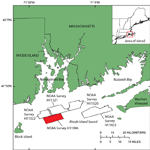
Figure 1. Index map showing location of the National Oceanic and Atmospheric Administration (NOAA) survey H11996 study area in Rhode Island Sound. Other NOAA surveys in Rhode Island Sound interpreted as part of our research cooperative include: H11320 (McMullen and others, 2007), H11321 (McMullen and others, 2008), H11322 (McMullen and others, 2009), and H11922 (Poppe and others, 2011). |
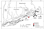 |
Figure 2. Map of end moraines (black polygons) and submerged ridges (dashed lines) in southern New York and New England (modified from Gustavson and Boothroyd, 1987) with location of study area (red polygon). The Ronkonkoma-Block Island-Nantucket end moraine represents the maximum advance of the Laurentide Ice Sheet about 20,000 to 24,000 years ago, and the Harbor Hill-Roanoke Point-Charleston-Buzzards Bay end moraine represents a retreated ice-sheet position from about 18,000 years ago (Uchupi and others, 2001). The submerged moraine crosses through the western part of the study area. |
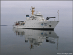 |
Figure 3. The National Oceanic and Atmospheric Administration (NOAA) Ship Thomas Jefferson. Photograph taken by Dan Wright, NOAA. |
 |
Figure 4. RESON SeaBat 7125 multibeam echosounder, hull-mounted to the National Oceanic and Atmospheric Administration Ship Thomas Jefferson, used to collect bathymetric data during survey H11996. |
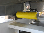 |
Figure 5. RESON SeaBat 8125 multibeam echosounder, used to collect bathymetric data on National Oceanic and Atmospheric Administration launch 3101 during survey H11996. |
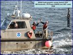 |
Figure 6. Launch 3101, used to collect bathymetric data for National Oceanic and Atmospheric Administration survey H11996 with able seaman Haulander, physical scientist Poppe, and senior survey technician Lewit aboard. |
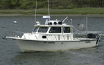 |
Figure 7. The U.S. Geological Survey research vessel Rafael, used to collect bottom photography and sediment samples on cruise 2010-033-FA. |
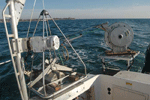 |
Figure 8. The small SEABed Observation and Sampling System (SEABOSS), a modified Van Veen grab sampler equipped with still and video photographic systems, mounted on the aft starboard side of the research vessel Rafael. The system uses a winch, mounted on a davit (left), and a take-up reel for the video-signal and power cable (right). |
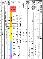 |
Figure 9. Chart showing the relations among phi sizes, millimeter diameters, size classifications (Wentworth, 1922), and American Society for Testing and Materials and Tyler sieve sizes. Chart also shows the corresponding intermediate diameters, grains per milligram, settling velocities, and threshold velocities for traction. |
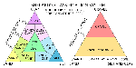 |
Figure 10. Sediment-classification scheme from Shepard (1954), as modified by Schlee (1973) and Poppe and others (2004). |
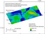 |
Figure 11. Hill-shaded multibeam bathymetry from National Oceanic and Atmospheric Administration survey H11996. Warmer colors (yellows) are shallower areas; cooler colors (purples) are deeper areas. Red boxes show locations of figures 13, 14, 15, and 16. |
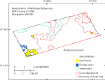 |
Figure 12. Interpretation of sea-floor features in the multibeam bathymetry from National Oceanic and Atmospheric Administration survey H11996. |
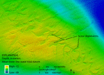 |
Figure 13. Detailed multibeam bathymetry showing scour depressions on a bathymetric high in the eastern part of the study area. Location of image shown in figure 11. |
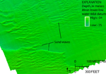 |
Figure 14. Detailed multibeam bathymetry showing sand waves with east-west oriented crests. Location of image shown in figure 11. |
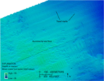 |
Figure 15. Detailed multibeam bathymetry of trawl marks on the flanks of a hummocky bathymetric high. Hummocks are generally tens of meters in length. Also visible in the image are numerous shallow scour depressions. Location of image shown in figure 11. |
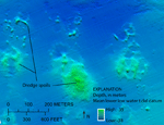 |
Figure 16. Detailed multibeam bathymetry of dredge spoils located in disposal site 69b. Location of image shown in figure 11. |
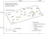 |
Figure 17. Location of sediment samples taken during U.S. Geological Survey cruise 2010-033-FA. Warmer colors (reds) indicate coarser grain sizes and cooler colors (greens) indicate finer grain sizes. |
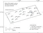 |
Figure 18. Location of bottom photographs taken during U.S. Geological Survey cruise 2010-033-FA. |
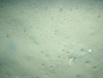 |
Figure 19. Photograph of a typical sandy sea floor at station 996-7, located in the north-central part of the study area, showing burrows, scattered shells, and animal tracks. Location of photograph shown in figure 18. |
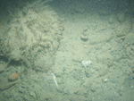 |
Figure 20. Photograph of gravel at station 996-11, located in the central part of the study area. Gravel is overgrown with seaweed and hydrozoans, and a thin veneer of fine-grained debris covers much of the surface. Location of photograph shown in figure 18. |


