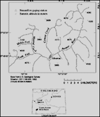
Upper Animas River, Colorado
| Goal: Reduce both environmental contamination and the cost of cleaning up existing contamination. |
| The USGS role is to identify and define the occurrence and effects of contamination, broaden our basic understanding of contaminant hazards, and provide pertinent information to those concerned with mitigation and prevention. |
The Toxic Substances Hydrology Program has developed field methods for assessing releases from leaking underground storage tanks of MTBE in ground water and for assessing the efficiency of natural attenuation processes (biodegradation, sorption, dilution). This methodology is being adopted by the South Carolina Department of Health and Environmental Control to integrate consideration of fuel oxgenates (such as MTBE) into the State Underground Petroleum Emergnecy Response Bank program. By adopting USGS methods, South Carolina is saving the costs (estimated at $400,000) and the time (estimated at 2 years) associated with developing their own protocol.
|
Upper Animas River, Colorado |
In FY 1997, the USGS successfully implemented the Abandoned Mine Lands (AML) Initiative. The goal of this 5-year initiative is to develop a watershed approach to gathering the scientific information needed by Federal land management agencies to effectively and cost-efficiently remediate contamination associated with abandoned mine lands. A significant early accomplishment of the AML Initiative is the completion of four tracer injection studies in mountain streams affected by acid mine drainage. A tracer injection study identifies and prioritizes the many individual sources of metals and acid in a mountain watershed, thus enabling targeting of resources on contaminant sources that will have the greatest improvement in watershed quality. The tests were conducted in the Initiative's pilot watersheds, the Upper Animas River, Colorado, and the Boulder River, Montana. As a result of their success, two additional tests were requested by USGS to support their decisions related to remediation at Fisher Creek, Montana (New World Mine), and Wightman Fork, Colorado (Summitville Mine). |
Additional information about the AML Initiative can be found at:
Additional information on tracer-injection studies can be found at:
|
The Southwest Water Quality Conservation District, the Bureau of Reclamation, the Southern Ute Indian Tribe, and the City of Durango requested a USGS baseline study of metals in the Animas River in Colorado to understand the source, transport, and fate of metals and impact on water quality. More than 90 percent of the metals present in stream sediments were derived from the intensely mined watershed above Silverton, Colorado. USGS measured current levels of metals contents of the Animas and these data provided a baseline to evaluate the effect of planned remediation work above Silverton. The goals are to improve the quality of drinking water for the City of Durango and the quality of irrigation water within the watershed. The Bureau of Reclamation is using these data to evaluate metal loads, especially selenium, resulting from pumping Animas River water into the proposed Animas-La Plata Reservoir.
This study directly benefits public and environmental health and allows policymakers and land planners to better manage their water resources. |
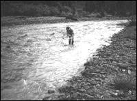
John Besser (USGS-BRD) collecting invertebrate sample, Mineral Creek, Animas River Watershed above Silverton, Colo. |
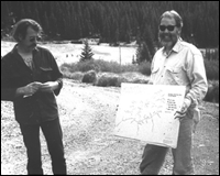
Paul Von Guerard (USGS-WRD) and Bill Simon (Animas River Stakeholders Group) making a presentation on remediation plans in Animas Basin, Colo. |
Water Availability and Quality || Natural Hazards || Geographic and Cartographic Information || Contaminated Environments || Land and Water Use || Nonrenewable Resources || Environmental Effects on Human Health || Biological Resources Return to Business Activities