Geographic and Cartographic Information
|
Goal: Provide maps and map data for the Nation.
|
|
The USGS role is to acquire, produce, manage, and disseminate geospatial data; cultivate partnerships with other governmental organizations, academia, and the private sector for geospatial-data activities; provide leadership in establishing National geospatial data policies and standards; and conduct a geographic research and development program focused on interpretation and application of geospatial data.
|
FY 1997 Accomplishments
Digital Ortho-Imagery
A total of 60,850 digital ortho-imagery quadrangles (DOQ's) were completed during FY 1997 and are now available in the archive. This represents 28% of national coverage, 3 percent greater than the goal attainment level for FY 1997. Additional progress made in the DOQ program during FY 1997 included the following activities:
- The new DOQ Architecture & Engineering contract was awarded to nine contractors; five were continued from the first DOQ contract, and there are four new contractors.
- A second Innovative Partnership agreement with Texas was signed, for statewide DOQ coverage.
- Planning was initiated for second time DOQ coverage ("revised" DOQ's or DOQ maintenance).
- Joint funding agreements were signed for full State DOQ coverage or to complete DOQ's in the State with North Carolina, Pennsylvania, Kentucky, Missouri, Oklahoma, and Ohio.
- High-visibility project work in FY 1997 include the U.S./Mexico border project, DOI high-priority projects, the Chesapeake Bay Ecosystem project, and the Yellowstone National Park and Environs project.
- Research has begun on the viability of using satellite data for mapping purposes. Work will intensify once the new higher resolution satellites are up and data become available.
Geospatial and Remotely Sensed Data
In FY 1997 the cumulative amount of geospatial and remotely sensed data archived and managed by the USGS was over 144,000 gigabytes, 22,000 gigabytes more than previously projected goal attainment level. The data archive contains 120,000 gigabytes of Landsat satellite data, 12,000 gigabytes of Advanced Very High Resolution Radiometer (AVHRR) satellite data, and 12,000 gigabytes of geospatial data (digital orthophoto quads, digital elevation models, and digital features data). Archiving and managing ensure the long-term preservation of these data, in conjunction with a mandated responsibility to distribute the data on demand to a global community of scientific users. The USGS will synthesize thematic spatial data from various scientific and cultural fields to promote creative solutions to resource and development issues.
Geospatial data integration techniques and applications in multidisciplinary science activities.
Eight innovative geospatial data integration applications were developed in FY 1997 to synthesize thematic spatial data from various scientific and cultural fields to promote creative solutions to resource and development issues. Detailed below are the eight applications.
- Mississippi River Basin data set. This data set models the role of land use, erosion, sedimentation, and soil development on carbon storage and nutrient cycles. The aim of the application is to better understand and balance the carbon cycles. (See fig. 1.)
|
Figure 1
|
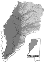
Figure 2
|
- Yazoo River Basin data set. The Yazoo River Basin is located in the northwestern portion of the State of Mississippi. Data on soil, land cover, and climate are used as input to models of soil erosion, sedimentation, and carbon stoage and flux. The project includes application methods for compiling, integrating, and analyzing spatial data. (See fig. 2.)
|
- Rio Puerco River Basin project. This project is located west of Albuquerque, New Mexico. It is a global change research study to develop information and gain knowledge about the inter- action of climate and land use change on the environmental, economic, and social systems of the region. (See fig. 3.)
|
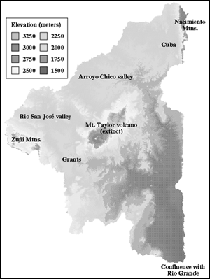
Figure 3. Topography of the Rio Puerco basin of New Mexico
|
- Completion of the Global 30 Arc-Second Elevation Data Set. The USGS created this global digital elevation model with horizontal grid spacing of 1 km -- also called "GTOPO30." In developing this application, the USGS worked with the National Oceanic and Atmospheric Administration (NOAA), the National Aeronautics and Space Administration (NASA), and many international partners to compile extended coverage of global 10-day, 1-km AVHRR composite land data sets to cover the period from April 1992 to July 1995. This is the first ever global geospatial data set with a spatial resolution of about 1 kilometer. It is accessible on the Internet and allows modelers to more accurately portray the Earth's global- and regional-scale terrain than ever before. (See fig. 4.)
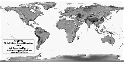
Figure 4
|
- Completion of the Global Land Cover Characterization Database. This database, also accessible over the Internet, provides modelers with a flexible data source for use in describing the land surface in whatever way they require.
- Merged thematic layers of quadrangles in the National Hydrographic Dataset for a composite readout.
- Submerged aquatic vegetation application for monitoring riparian habitat.
- Global Positioning System data applied in a new way for digital elevation models in south Florida.
Maps Aid Restoration of Great Lakes Fishery
USGS scientists mapped spawning habitat for lake trout in Lake Huron and yellow perch in Lake Michigan by using sidescan sonar, a remotely operated, underwater vehicle equipped with a closed-circuit television system, geographic positioning systems, and a computer-based geographic information system. The maps are needed to implement fishery management actions for these species as part of the Great Lakes fishery restoration effort.
Distribution of Submerged Aquatic Vegetation
USGS scientists have completed high resolution (1:24,000 scale) maps of submerged aquatic vegetation (SAV) from Chandeleur Islands, Louisiana, to Anclote Key, Florida. This information will be used by the Minerals Management Service and the U.S. Fish and Wildlife Service for coastal zone planning and management. These agencies identified the mapping of SAV as their number one habitat-information need in this geographic area.
|
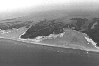
Storm overwash fan deposited on a seagrass bed in the Chandeleur Islands, Louisiana.
|
National Parks Vegetation Maps
The USGS continues to implement a multiyear program to map vegetation in 234 high-priority National Parks. This program's purpose is to provide vegetation maps and associated field data to be used in association with other geographic information system (GIS)-based maps for resource management, research, planning and compliance, interpretation and operations. In FY 1997 the first prototype park project was completed, which tested program standards and protocols for implementation at other parks in desert ecosystems. Work also began in 5 new National Parks and brought the total number of parks with work underway to 33. In FY 1997 the USGS conducted a peer review of this program in FY 1997; the review involved 21 invited scientists from 6 Federal agencies and included a training session on the "Application of the Federal Geographic Data Committee National Classification Standard" for 25 scientists from 5 Federal agencies.
Gap Analysis Program
The Gap Analysis Program (GAP) identified and classifies the elements of biological diversity at State and regional levels, providing a standardized means to inventory and map the distribution of vegetation communities, terrestrial vertebrate species, and land management status. USGS scientists use satellite images, aerial video, existing maps, and field reconnaissance to develop land cover, species distribution, and habitat maps. These data are used to identify species and habitats that are underrepresented in the network of conservation lands and related activities and which are at risk of becoming conservation crises. The information is used by local, State, Federal, and private land managers. GAP uses a cooperative State-based business model. In FY 1997 the program was active in 44 States, in collaboration with 470 cooperating universities, businesses, State, local and other Federal agencies. GAP substantially improved the ability of these entities to access and use ecological information.
|
|
A gap analysis example
The analysis of potential gaps in biological conservation can take many forms. For example the Grace's Warbler (Dendroica graciae) analysis in New Mexico would predict the warbler's distribution and status of highest management for biodiversity and other management status. The analysis
would show the percent of the warbler's habitat occuring in areas that are managed for biodiversity.
This type of analysis helps to identify any potential "gap" in the warbler's management status and it may be vulnerable to future endangerment.
|
|
USGS Water Resources Data on the Internet
Historical streamflow data is available on the Internet for all 50 States. Having this information available is a valuable tool for Federal and State agencies when they are designing water resource projects or making water resource decisions.
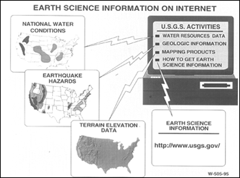 Real-time streamflow information is available for all States except Hawaii. The real-time streamflow sites are the most popular and useful sites on the USGS water resources Internet pages, with an estimated 1.2 million real-time hydrographs being downloaded from January to September 1997. Not only is this information critical to resource managers and emergency management coordinators during times of flooding, but citizens also use the information for making decisions about when and where to repair the dikes and levees on their farms, when to move their property to higher ground, and when to evacuate.
USGS water resources Websites are building a loyal clientele. For example, 18,000 users of USGS water resources Websites, 16 percent of the total, come back more than once per month.
Almost 96 percent of users are from outside the USGS, the majority, 78 percent, are from commercial sites, about 12 percent are from educational domains, 6 percent are foreign, and 4 percent are from government sites other than the USGS.
"Webmaster Magazine" named the USGS one of its "50/50" awardees as one of the 50 Internet sites contributing most to its organization's business purpose. The USGS was chosen by a panel of judges from over 700 entrants, who included many major corporations and government sites.
Public Education on Pesticides
A NAWQA fact sheet titled "Pesticides in selected small streams in the Puget Sound Basin, 1987-1995" is being used by King County, Washington, as part of an educational effort to encourage homeowners to use less pesticides on lawns and gardens.
New Report on Method for Rapid Estimation of Bridge Scour
Scour at highway bridges involves sediment transport and erosion processes that cause streambed material to be removed from the bridge vicinity. This process weakens bridge foundations and, if not corrected, can eventually result in bridge collapse.
Because almost 485,000 bridges in the U.S. are over waterways and may be susceptible to scour to some degree, a detailed scour analysis at all sites may not be feasible. As part of a National program to determine which bridges in the U.S. are susceptible to scour, tens of thousands of bridges nationwide are being inventoried. By using the methods described in a new USGS report, estimates of scour depths at highway bridges can be obtained for a site in a matter of hours, based on limited site data, whereas traditional methods required days to calculate scour estimates.
|
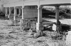
Example of bridge scour. (USGS)
|
Water Availability and Quality ||
Natural Hazards ||
Geographic and Cartographic Information ||
Contaminated Environments ||
Land and Water Use ||
Nonrenewable Resources ||
Environmental Effects on Human Health ||
Biological Resources
Return to Business Activities
This page is https://pubs.usgs.gov/97financial/geographic.html
Maintained by John Watson
Last updated June 19, 1998