Natural Hazards
|
Goal: Reduce the loss of life and property from natural hazards.
|
|
The USGS roles are to advance our understanding of the fundamental processes that control or trigger hazardous events or situations; lead in developing real-time monitoring and warning systems; and enhance the use of hazards assessments by decisionmakers, in order to improve disaster response and mitigation planning.
|
FY 1997 Accomplishments
Flooding in Louisiana
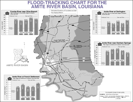
Flooding in Louisiana is a serious and recurring problem. Seven major floods have occurred in the basin since 1977, primarily the result of backwater flooding along the Amite and Comite Rivers and their tributaries. In cooperation with the Amite River Basin Drainage and Water Conservation District, the USGS Louisiana District has established a flood monitoring network in the Amite River Basin to provide real-time stage and discharge data to emergency response agencies and the general public.
During a flood event, real-time data are available through the USGS Louisiana District home page on the Internet and also by a telephone information line provided by a local newspaper and updated frequently by USGS staff. In addition to these resources, the USGS published a "Flood Tracking Chart" for the Amite River Basin, Louisiana (USGS Open-File Report 96-649). Modeled after a hurricane tracking chart common along the Gulf and Atlantic Coast States, the chart includes a map showing the location of gages from which real-time data are available during floods and bar charts showing the relative peaks of historical floods at each station. By providing this geographical and historical context, the chart aids users in understanding and responding to a flood.
A local Congressman from Baton Rouge combined the tracking chart with public safety information from a local USGS cooperator and published it in a mail-out to 290,000 Baton Rouge area residents, with appropriate credit to the USGS. He further pointed out that communities in his district could claim public education credit from Federal Emergency Management Agency for his mail out and help lower their flood insurance rates.
Improved Aviation Safety
With funding from the Federal Aviation Administration (FAA), the USGS expanded its monitoring activities at the Alaska Volcanic Observatory (AVO) in 1996 and 1997. Volcanic ash erupted high into the atmosphere is very hazardous to modern high-performance aircraft because it erodes compressor blades, melts onto critical engine parts, and causes loss of engine power. Hazardous concentrations of volcanic ash can drift at air-traffic altitudes for hundreds to thousands of miles downwind following a volcanic eruption. Worldwide, about 80 jet aircraft in the past 5 years have accidentally entered volcanic-ash clouds and put thousands of passengers at risk. Within U.S.-controlled airspace, the ash-aviation issue is especially important in the North Pacific region where many active and potentially active volcanoes are overflown daily by commercial and military aircraft in heavily traveled international and domestic air routes. By using data from its monitoring networks, the USGS provides eruption reports and prognoses of future activity to the National Weather Service (NWS), the FAA, and the aviation industry. The NWS uses USGS information to help track eruption clouds, and the FAA uses the USGS and NWS information to route air traffic away from dangerous ash clouds. In 1996, USGS monitored seismic unrest at three Alaskan volcanoes and tracked eruptions at an additional three, as well as one in the Kamchatka Peninsula of Russia.

Volcanic-ash hazard warnings for air traffic in Alaska
|
National Seismic Hazard Maps
The USGS recently completed and released new national maps showing the potential hazard from earthquakes and earth tremors. These maps show variations in the hazard related to different rates of earthquake occurrence across the country. The California portion was produced jointly by the USGS and the California Division of Mines and Geology, setting a precedent for Federal-State cooperation in seismic hazard mapping. The maps were reviewed in detail by two panels of experts and are available in print and via the Internet. The maps present data in the formats most requested by engineers and land-use planners and are being used for the National Earthquake Hazards Reduction Program Recommended Provisions for Seismic Regulations for New Buildings, as well as for designing bridges, planning retrofitting strategies, setting insurance premiums, and estimating earthquake losses.
Global Seismograph Network
|
Water Availability and Quality ||
Natural Hazards ||
Geographic and Cartographic Information ||
Contaminated Environments ||
Land and Water Use ||
Nonrenewable Resources ||
Environmental Effects on Human Health ||
Biological Resources
Return to Business Activities
This page is https://pubs.usgs.gov/97financial/hazards.html
Maintained by John Watson
Last updated June 19, 1998