          3-D Reservoir Characterization of the House Creek
           Oil Field, Powder River Basin, Wyoming, V1.00
Table of contents | Readme first | Movie readme | Data set readme | Glossary | Geology | Depositional model | Heterogeneity | Diagenetic history | Petroleum geology | 1) East-West porosity slices | 2) North-South porosity slices | 3) Onion views of 3-D images | 4) Horizontal slices of porosity | 5) Horizontal and East-West permeability and porosity slices
TECHNICAL INFORMATION
INCLUDED IN THIS SECTION ARE THE FOLLOWING;
Sources of information include published reports, core and outcrop studies, geochemical analyses of crude oil and core samples, core analyses, petroleum reserve and production data, and well data. The Sussex Sandstone core used in this study is located at the U.S. Geological Survey (USGS) core library in Denver (Higley, 1988) and at the Colorado School of Mines in Golden, Colorado. Sources of field and well production data include Petroleum Information Corporation's (PI) production data on CD-ROM and Well History Control System databases; unless otherwise stated, data are current approximately through July 1993. Meridian Oil Company and Woods Petroleum Corporation provided core analysis and reservoir production and statistical data. Our geologic and geochemical analyses was augmented by other sources of information; these include Kerr-McGee Corp., Woods Petroleum Corp., Meridian Oil, Petroleum Information Corp., and State of Wyoming Oil and Gas Conservation Commission.
Microsoft Excel, DeltaGraph, and Canvas statistical and graphics programs on Macintosh computers were used to generate most of the charts and graphs used in figures. Statistical and graphical distributions of results from thin-section petrographic analyses and well-log and core-porosity and core-permeability data were calculated using Statistical Applications Software (SAS) on a VAX computer, and Microsoft Excel and DeltaGraph programs on Macintosh computers.
Generated maps primarily cover the southern two-thirds of the House Creek field, although geology, geochemistry, and petroleum potential of the entire field was researched. EarthVision (EV) version 2.02 program on an IRIS workstation was used to generate contour maps and the 3-D maps illustrating porosity and permeability distribution across the field. The mapping package is owned by Dynamic Graphics Corporation, Berkeley, Calif. The IRIS workstation had 32 MB of memory and operating system 5.3.
The 3-D maps of core and well-log porosity represent an area of 105.28 to 105.42 degrees longitude (X-axis grid dimensions of 25,000 to 43,000 m) and 43.4 to 43.5 degrees latitude (Y-axis grid dimensions of -16,000 to -35,000 m). Permeability data were derived from core analyses; data distribution are within about 105.5 to 105.6 degrees longitude (X-axis grid dimensions of 26,500 to 33,000 m) and 43.7 to 43.8 degrees latitude (Y-axis grid dimensions of -28,000 to -16,000 m). All data set references include only approximate X-Y coordinates; actual well locations are slightly different.
The porosity/permeability and other geologic data sets created for this study were gridded by the EarthVision mapping programs using a biharmonic cubic spline algorithm that distributes tension among the grid nodes. Contour curvature is distributed rather than concentrated at nodes. Generated isopach, structure, and other contour maps display this curvature, as opposed to jagged contour lines. Most maps use a closely spaced grid with one to a maximum of eight data points (wells) evaluated from each grid node; these parameters display anomalies and wide variations on the maps, as opposed to smoothing data. 3-D maps utilize single-data-point gridding to minimize extrapolation. Using these contour parameters, map features are sometimes exaggerated; this can result in mammiform (essentially bull's-eye) contours when adjacent or proximal wells have widely different data values.
Vertical slices through the field show dispersal of permeability and porosity; slices were chosen based on 3-D distribution of core data and well control. Most figures exhibit, and include, considerable Z-axis exaggeration; the purpose is to better show porosity and permeability distribution within the Sussex. Vertical exaggeration is listed on figures. The exaggeration results in a greatly increased upward and shoreward (westward) step in sand-ridge unit (sandstone bed) boundaries. Actual boundaries are at a much lower angle.
3-D models of porosity respective grid spacings were 100 by 100 cells (200 by 200 m), and 250 by 250 cells (85 by 85 m) in the X-Y (east-west, and north-south) directions, and 50 cells (1.5 ft) in the Z (depth) dimension; movie images were gridded using the closer (250 by 250) cell spacing so animations would flow better. Permeability was gridded using a 30 by 30 grid cells in the X-Y direction and 50 grid cells in the Z direction; the smaller X-Y grid spacing results from the smaller areal extent of this 3-D data. The Z spacing grid nodes represent increments of about 1.5 ft (0.5 m) for the interval from 10 ft (3.5 m) below the Sussex "B" base to 65 ft (20 m) above it. A closer grid was not practical because of the EV program parameters. The X-Y-Z grid parameters were chosen in order to treat porosity/depth values for each well separately. The purpose of this is to better see variation in porosity in 3-D space, and to evaluate the effects of lateral permeability boundaries on the distribution of porosity. These permeability boundaries are located between individual reservoir sand ridges. They also bound the Sussex "B" sandstone interval.
The *.RGB image files generated using EarthVision were converted on the IRIS workstation into *.GIF (Graphic Interchange Format) and *.TGA (TARGA) files. These graphics files were then downloaded onto Macintosh and PC computers. GraphicConverter version 2.1.3 shareware on a Macintosh was used to generate the movies. Each GIF file folder was opened using the "convert all," command located under the file menu banner. Next, "select folder" and "convert" were selected. Movies were saved using 640 X and 430 Y pixels (movie width and height) and 256 colors (8 bit). Selected compression settings were highest quality, and 1 frame per second display time (for most of the movies). Movies were opened using Apple Computer, Inc., MoviePlayer version 2.0b2 software and saved as single-forked stand-alones.
Outcrops of Sussex and Shannon Sandstones in the Salt Creek anticline area and Shannon Sandstone outcrops west of the anticline were examined and described. Due to the poor quality of Sussex outcrops, Shannon Sandstone outcrops were used as analogs to the Sussex and to depositional processes in the Cretaceous epicontinental seaway. Outcrops west of the Salt Creek anticline, just east of Shepperson Ranch, were also studied. The outcrops locations, shown with a blue rectangle on the following (indexfs3.gif) index map, are near Edgerton and Midwest, Wyoming, northeastern Natrona county in townships 39 and 40 north and ranges 78 through 80 west.
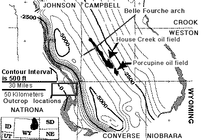
Figure 1. Structure contour map on the top of the Upper Cretaceous Sussex Sandstone Member of the Cody Shale, and approximate age equivalents, Powder River Basin, Wyoming and Montana. Location of the House Creek field is shown. Areal extent of the Sussex "B" sandstones is delineated by black-colored fields. Shaded fill outlining the basin are outcrops of Lance Formation and Fox Hills Sandstone. The rectangle located next to the 30-mile scale bar defines the area of studied outcrops of the Sussex and Shannon Members, much of the Salt Creek anticline, Shepparson Ranch, and the towns of Midwest and Edgerton. Contour interval is 500 ft. Datum is mean sea level.
The Sussex Sandstone outcrops northwest of Edgerton, Wyoming, and along the northeastern flank of the Salt Creek anticline. Largely because of Pleistocene and present-day erosion, the uppermost sandstones of the Sussex are commonly missing (Brenner, 1979). These missing intervals probably include the trough-cross-bedded sandstones that are the primary reservoir facies in the House Creek field. Exposed in outcrop are coarsening-upward sections of laminated mudstones to fine- to medium-grained sandstones. These thin-bedded sandstone facies have lower reservoir favorability.
Facies assignments were determined from outcrop and core studies and by correlation of lithologic data to geophysical well logs. Sussex "B" core from 20 wells were examined. Descriptions in Higley (1992, 1994) include sedimentary structures, changes in depositional energy, grain-size distributions, degree and types of biologic activity, trace-fossil assemblages, generalized amounts of calcite and quartz cements, and presence of clasts of chert, glauconite, and siderite.
Depths to the top and base of the Sussex "B" sandstone and of the sand ridges (sandstone bed) that comprise it were determined from outcrop, core, petrologic, geochemical, well-log, and published sources. Depths to the Ardmore bentonite, and to the top and base of the Sussex Sandstone Member and included Sussex "B" sandstone were picked from well-logs of more than 620 wells within, west of, and slightly east of the House Creek field. These depths were added to a digital data file that also included American Petroleum Institute (API) number, well name, operator name, well location, and well symbol (oil producing, dry hole, etc.), total drill depth, producing formation, and completion year. Also added to the well file were depths to boundaries of major Sussex "B" sandstone flow units, as determined for about 120 wells in the field (Higley, 1994). Flow units are strata that exhibit similar fluid-flow characteristics. Examples are thick, trough-cross-bedded, medium-grained sandstones, and low-porosity, non-oil-productive shales. Porosity, permeability, formation and sand ridge tops, and other data are explained in the dreadme.htm file for the three data sets located in the data_set folder. Included files are named ssxporos.dat, corepor.dat, and ssxtops.dat.
Cores from 10 wells located in and near the House Creek and Porcupine oil fields were sampled for petrographic analysis. Thin sections of 54 samples, X-ray diffraction (XRD) analyses, cathodoluminescence, and scanning electron microscope (SEM) studies were used to determine reservoir paragenesis, sandstone porosity, and mineralogical constituents of the Sussex "B" sandstone in the study area. Results of the petrographic analyses are presented in Higley (1992, 1994) and listed in table 2 (below).
Cathodoluminesence analysis was used to evaluate early diagenetic events not visible with standard petrographic procedures. Calcite-cemented sandstones and chert-pebble sandstones were sampled. Locations of calcite-cemented facies were chosen based on core and thin-section examination. Specially prepared 30-micrometer-thick thin sections for the cathodoluminesence studies were polished at low temperature and contain no epoxy or stains. We used a Technosyn Mark II cathodoluminescence stage with 10-15 Kv beam potential and 400-500 microampere beam current. The thin-section vacuum stage operated at range of 50-100 millitorr. Samples were viewed through a Nikon Optiphot microscope fitted with 8X oculars and a 4X (0.12 numbered aperture) objective.
Scanning electron microscope (SEM) examination of core samples determined mineralogical constituents, diagenetic history, shapes of pores, and petrologic characteristics of Sussex "B" sandstone, mudstone, and siderite core samples. SEM and other petrologic data are included in Higley (1992, 1994).
The Ardmore bentonite through Sussex "B" sandstone interval was correlated by linking well log traces for 120 wells. Traces include gamma, spontaneous potential (SP), resistivity, and bulk density. Steve Fillingham of Woods Petroleum Corp. (1985, personal communication), identified a 10 MV SP deflection to define the gross sandstone interval; this was also noted in this study as a boundary between reservoir-grade sandstone beds, and non-reservoir mudstones and cemented sandstones. This boundary is also characterized by a rapid decrease in core and well-log porosity. The boundary occurs at approximately 8.5 percent porosity, although this varies somewhat based on interbedding characteristics of mudstone/sandstone beds.
Sussex Sandstone core porosity and permeability data for as many as 30 wells in the area are included in the data_set porosity database and the 2-D and 3-D map images. Thirteen of these wells are within the field boundaries; well locations are shown below. Porosity values were calculated from bulk density well-log traces for approximately 100 wells. Sonic log traces were used for porosity calculations for a few wells.
Permeability baffles and barriers between stacked sandstones are characterized on well logs by sonic and bulk-density "spikes" of low porosity, variable gamma signatures that indicate shale breaks, and irregular spontaneous potential and resistivity traces that show stacked thin sandstones with intervening breaks. Limitations to the model include incomplete knowledge of reservoir heterogeneity, including information on fault and fracture systems, on continuity of small-scale permeability baffles such as shales and cemented sandstones, and permeability of porous facies and zones for which there are few core analogs.
Porosity was calibrated to a specific grain density of 2.68 g/cm3; this approximates average grain densities determined from the core analyses and estimated from thin-section examinations. Field outlines and sedimentologic boundaries were based on published information, well-log correlations, porosity and permeability profiles, oil-productive characteristics, location of sandstone and shale beds within the ridge system, and on core and outcrop studies.
Table 1 shows names and locations of cored wells that were used in thin-section petrographic and other studies; depth to the top of the Sussex "B" sandstone is also listed. Table 2 has volume percent of detrital grains, cements, and porosity for 55 thin sections of Sussex "B" sandstone core samples from 10 boreholes. Table 2 is also saved as the tab-delimited ssxtabl2.txt file because each web-browsing program displays (or dissects) tables differently. Porosity and mineralogical determinations were derived using approximately 300 point counts of each thin section. Thin sections were stained for calcite, potassium feldspar, plagioclase, and iron. Blue epoxy fills pore spaces. Minus-cement porosity (MCP) column includes volume percentages of chlorite, kaolinite, and pyrite, added to amounts of chert, quartz, calcite, dolomite, and feldspar cements. MCP is an estimate of porosity at the time of lithification. Photomicrographs for many thin sections are included in the geology text section of this publication.
TABLE 1
Names and locations of wells in Campbell County, Wyoming, in which core was sampled for petrographic analysis of the Sussex "B" sandstone, Sussex Sandstone Member of the Upper Cretaceous Cody Shale. Locations are section, township, and range (glossary). An asterisk (*) marks the estimated core depth to the top of the Sussex "B" sandstone; other depths are actual core depths.
| Well Name | Location, | Top Depth (ft.) |
|---|---|---|
| 14-9 Federal | 9, T. 42 N., R. 71 W. | 7,781 |
| 1 Campbell | 21, T. 42 N., R. 71 W. | 7,700 |
| 1 Govt. Miles "A" | 9, T. 44 N., R. 73 W. | 8,189 |
| 1 Mandel Federal | 22, T. 44 N., R. 73 W. | 8,166 |
| 1-23 House Creek Fed. | 23, T. 44 N., R. 73 W. | 8,238 |
| 1 Empire-Federal "C" | 29, T. 45 N., R. 73 W. | 8,006 |
| 32-1 Marquiss "B" | 32, T. 45 N., R. 73 W. | 7,980 |
| 1 House Creek Fed. | 13, T. 45 N., R. 74 W. | 8,175 |
| 1-11 Red Unit | 26, T. 48 N., R. 79 W. | 9,028* |
| Ucross State | 11, T. 52 N., R. 81 W. | 8,233* |
TABLE 2
Thin-section point-count data for Sussex "B" sandstone facies. Facies definitions use those of Tillman and Martinsen (1985). Data are average volume percentages for number (N) of thin-sections listed; Q, quartz grains; PQ, polycrystalline quartz; FSP, feldspar grains; RF, rock fragments; GL, glauconite; MM mudstone matrix; MC, clay matrix; MS, mudstone drapes; SID, siderite drapes; PY, pyrite; CHL, chlorite; QC, quartz cement; CT, chert cement; FSP, feldspar cement; CA, calcite cement; KA, kaolinite booklets; PO, porosity; MCP, minus-cement porosity. Sedimentary facies are listed under column name FACIE for the entire data set (ALL), upper chert-pebble lag sandstone (CTSS), central ridge sandstone (CRSS), high- and low-energy ridge-margin sandstones (HRMS, LRMS), wavy-bedded sandstone (WBSS), and inter-ridge sandstone (IRSS) and siltstone (IRST) (Higley, 1992, 1994).
FACIE  N     Q   PQ    FSP   RF   GL    MM    MC    MS   SID   PY    CHL    QC   CT    FSP   CA    KA    PO   MCP
--------------------------------------------------------------------------------------------------------------------
ALL.   54   31   2.9   6.3   13   5.1   3.0   5.9   1.8   0.9   0.6   0.9   7.7   2.1   1.5   11.   0.8   5.4   30
--------------------------------------------------------------------------------------------------------------------

CTSS   03   27   0.8   3.5   36   3.0   0.0   2.1   0.0   0.0   0.2   0.0   1.9   0.0   0.2   21.   0.0   1.6   25

CRSS  17   32   2.9   5.7   14   4.7   0.7   3.9   2.1   2.9   0.3   0.8   8.5   2.1   1.3   9.5   0.4   7.7   31

HRMS  08   30   2.7   7.1   11   5.5   2.8   3.8   1.2   0.1   1.3   1.3   8.5   2.2   1.6   14.   0.5   6.1   36

LRMS  03   27   3.1   8.5   12   6.7   1.4   7.6   1.2   0.8   1.0   1.1   11.   1.9   3.8   9.7   0.9   2.4   32

WBSS  06   32   2.1   6.9   10   6.9   3.2   5.1   0.0   0.0   0.4   1.8   7.9   2.2   2.2   12.   1.6   5.9   34

IRSS   10   31   2.8   7.4   11   5.5   3.3   7.2   3.2   0.2   0.7   0.7   8.3   2.2   1.5   8.5   1.3   5.4   29

IRST   07   33   2.3   5.3   10   3.4   10.   13.   3.3   0.2   0.6   0.6   4.5   2.6   0.7   6.8   0.6   2.1   19