![]()
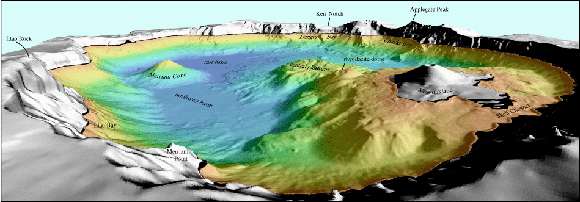 Shaded relief perspective image of Crater Lake looking southwest past Wizard Island. The colors represent depths of the crater bottom with reds being the shallowest and blues being the deepest; gray colored areas are above lake level.
In the summer of 2000, the bottom of Crater Lake, Oregon was mapped. The effort was a cooperative effort between the U.S. Geological Survey's Pacific Seafloor Mapping Project, the National Park Service, and the Center for Coastal and Ocean Mapping at the University of New Hampshire. The team used a state-of-the-art multibeam sonar system to collect high-resolution bathymetry and calibrated, co-registered acoustic backscatter to support both biological and geological research in the area (aquatic biology, geochemistry, volcanic processes, etc). This survey collected over 16 million soundings and the resulting data portrays the bottom of Crater Lake at a spatial resolution of 2 meters.
This CD-ROM is published for the scientific community, the general public, and as a teaching tool. The CD-ROM contains the raw multibeam bathymetry and backscatter data as well as an ArcExplorer 2.0 project for the scientific community to use in research. Computer-generated images and a fly-by movie allow any user to visualize the lake floor. Photographs and a QuickTime® movie of the helicopter operations shows how the multibeam survey took place and a list of Crater Lake publications and related websites can be used for further Crater Lake research and general interest.
Introduction -- A brief history of Crater Lake and Mount Mazama, shows a location map, and briefly explains why and how the Crater Lake mapping survey took place (12 kb).
ArcExplorer Project -- ArcExplorer 2.0 project showing both the multibeam bathymetry and backscatter data from Crater Lake. ArcExplorer is a freeware, lightweight GIS software package published by ESRI (12.9 MB).
Perspective Views -- Selected Perspective Views and Maps of Crater Lake, Oregon presented as an index map and 6 additional 300 dpi TIFF files (748 kb).
Fly-By Movie -- A Quicktime® "Fly-By" movie of Crater Lake (22.3 MB)
Helicopter Movie -- QuickTime® movie of the U.S. Army Reserve Chinook helicopter transport of the survey vessel into Crater Lake. (50.3 MB)
Data -- Bathymetry and Acoustic Backscatter Data of Crater Lake, Oregon collected during the multibeam survey July 28 to August 3, 2000 (23 MB).
Photographs -- A selection of 12 thumbnail photographs taken by the survey crew during the helicopter transport of the survey vessel into and out of Crater Lake (316 kb)
Publications -- This is a list of selected publications by USGS authors modified (March, 2001) from the Crater Lake Data Clearinghouse Bibliography (20 kb).
Links -- Selected links to related Crater Lake websites (8 kb)
Table of files contents -- CD-ROM table of contents for his publication (12 kb)
For questions about the content of this report, contact Peter Dartnell.
This report is also available on a CD-ROM from:
USGS Information Services, Box 25286,
Federal Center, Denver, CO 80225
telephone: 888 ASK-USGS; e-mail: infoservices@usgs.gov
Download a free copy of Adobe Reader
| Help
| PDF help |
| Publications main page
| Digital Data Series
| Department of the Interior
| U.S. Geological Survey |
| Geologic Division
| Coastal and Marine Geology |
| Privacy Statement
| Disclaimer
| Accessibility |
The URL of this page is:
https://pubs.usgs.gov/dds/dds-72/
Please send comments and suggestions, or report problems, to:
Michael Diggles
Created: June 11, 2002 (cad)
Updated: March 28, 2007 (bwr), March 10, 2009 (mfd)