Digital Data Series DDS-81
Version 1.0, 2003
 |
|
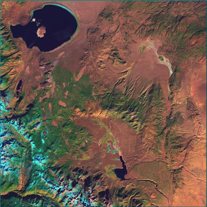
| Landsat image of the Long Valley-Mono Basin Region |
This database provides an overview of the studies being conducted by the Long Valley Observatory in eastern California from 1975 to 2001. The database includes geologic, monitoring, and topographic datasets related to Long Valley caldera. The CD-ROM contains a scan of the original geologic map of the Long Valley region by R. Bailey. Real-time data of the current activity of the caldera (including earthquakes, ground deformation and the release of volcanic gas), information about volcanic hazards and the USGS response plan are available online at the Long Valley observatory web page (http://lvo.wr.usgs.gov). If you have any comments or questions about this database, please contact the Scientist in Charge of the Long Valley observatory.
Systems requirements: IBM®-compatible computers running Windows®95 or higher or NT® 4.0 or higher with Intel® Pentium® or equivalent processor.
MacIntosh® with PowerPC processor.
Software: Web browser; ArcInfo® or ArcView® with Spatial Analyst®, or any GIS that is capable of importing ArcView Shapefiles.
We would like to thank D. Dzurisin and E. Endo (Cascades Volcano Observatory) for providing leveling and GPS data, R. Bailey for the geologic map and C. Roberts and B. Jachens for the gravity data, and D. Ramsey and J. Robinson for GIS support.
Geodetic data
DEM
DRG
Landsat
7
Rivers
Roads
Water Bodies
Web users: Download this entire publication (dds-81_CD.zip; 178 MB).
ArcView Project
ArcExplorer Project
README file for the CD-ROM version of this database (52 KB)
Living With a Restless Caldera | HTML | PDF |
Future Eruptions in California's Long Valley Area—What's Likely? | HTML | PDF |
Invisible CO2 Gas Killing Trees in the Mammoth Mountain Area | HTML | PDF |
Bibliography of Literature Pertaining to Long Valley Caldera and Associated Volcanic Fields | HTML | PDF |
![]()
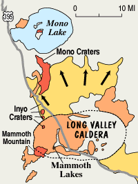
| The Caldera. Long Valley Caldera is a 15- by 30-km oval-shaped depression located 20 km south of Mono Lake along the east side of the Sierra Nevada in east-central California. This area of eastern California has produced numerous volcanic eruptions over the past 3 million years, including the massive caldera-forming eruption 760,000 years ago. The most recent eruption occurred just 250 years ago in Mono Lake at the north end of the Mono-Inyo Craters volcanic chain. |
| Volcanic Unrest. In May of 1980, a strong earthquake swarm that included four earthquakes of magnitude 6 or above struck the southern margin of Long Valley Caldera associated with a 25-cm, dome-shaped uplift of the caldera floor. These events marked the onset of the latest period of caldera unrest that continues to this day. This ongoing unrest includes recurring earthquake swarms and continued dome-shaped uplift of the central section of the caldera (the resurgent dome) accompanied by changes in thermal springs and gas emissions. |
| USGS Monitoring. In 1982, the U.S. Geological Survey under the Volcano Hazards Program began an intensive effort to monitor and study geologic unrest in Long Valley Caldera. The goal of this effort is to provide residents and civil authorities in the area reliable information on the nature of the potential hazards posed by this unrest and timely warning of an impending volcanic eruption, should one develop. Most, perhaps all, volcanic eruptions are preceded and accompanied by geophysical and geochemical changes in the volcanic system. Common precursory indicators of volcanic activity include increased seismicity, ground deformation, and variations in the nature and rate of gas emissions. |
Long-term Outlook. The area of eastern California that includes Long Valley Caldera and the Mono-Inyo Craters volcanic chain has a long history of geologic activity that includes both earthquakes and volcanic eruptions. This activity is likely to continue long into the future. |
1 Dept. of Geophysics, Stanford University, Stanford, CA 94305-2215
a Now at UC Berkeley Seismological Laboratory, 215
McCone Hall, Berkeley, CA 94720-4760
E-mail: battag@seismo.berkeley.edu
2 Branner Earth Sciences Library, Stanford University, Stanford, CA 94305
3 U.S. Geological Survey, 345 Middlefield Rd., MS977, Menlo Park, CA 94025
4 U.S. Geological Survey, P.O. Box 1360, Carnelian Bay, CA 96140
5 U.S. Geological Survey, Placer Hall, California CSUS, Sacramento, CA 95819-6129