Data Series 931
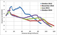
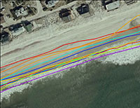
| Data DownloadsThe shoreline data download contains 13 MHW shorelines for Fire Island, N.Y., from October 28, 2012, to September 8, 2014. The shorelines are presented in Esri shapefile format. The shoreline shapefiles can be opened directly in Esri ArcGIS 10.0 or higher. The data layers provided can also be viewed using the free GIS viewer ArcGIS Explorer (http://www.esri.com/software/arcgis/explorer). The shoreline data file uses the projected coordinate system North American Datum of 1983 (NAD 83), Universal Transverse Mercator (UTM) Zone 18 North (18N). The cross-shore profile dataset contains 10 sets of profiles, covering 16 dates from October 28, 2012, to October 7, 2014. The profile data are provided in Excel and .csv file format. All elevations are referenced to NAVD 88.
|

![]() U.S. Department of the Interior |
U.S. Geological Survey
U.S. Department of the Interior |
U.S. Geological Survey
URL: http://pubsdata.usgs.gov/pubs/ds/0931/ds931_data-downloads.html
Page Contact Information: GS Pubs Web Contact
Page Last Modified: Monday, 28-Nov-2016 20:35:34 EST